NW9 5NG - 2 bedroom flat for sale in The Hyde, London, NW9
View on Property Piper
2 bedroom flat for sale in The Hyde, London, NW9
Property Details
- Price: £375000
- Bedrooms: 2
- Bathrooms: 1
- Property Type: undefined
- Property SubType: undefined
Brochure Descriptions
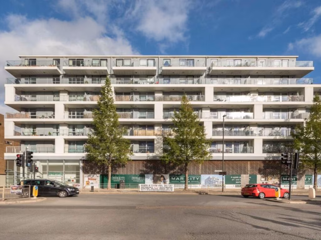
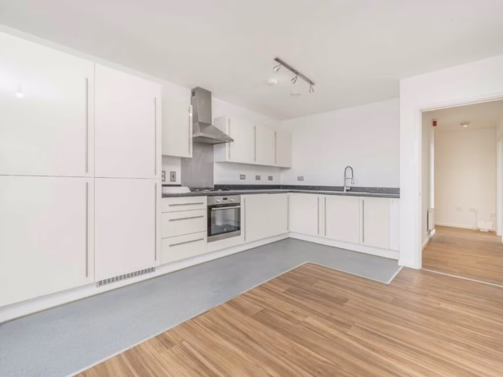
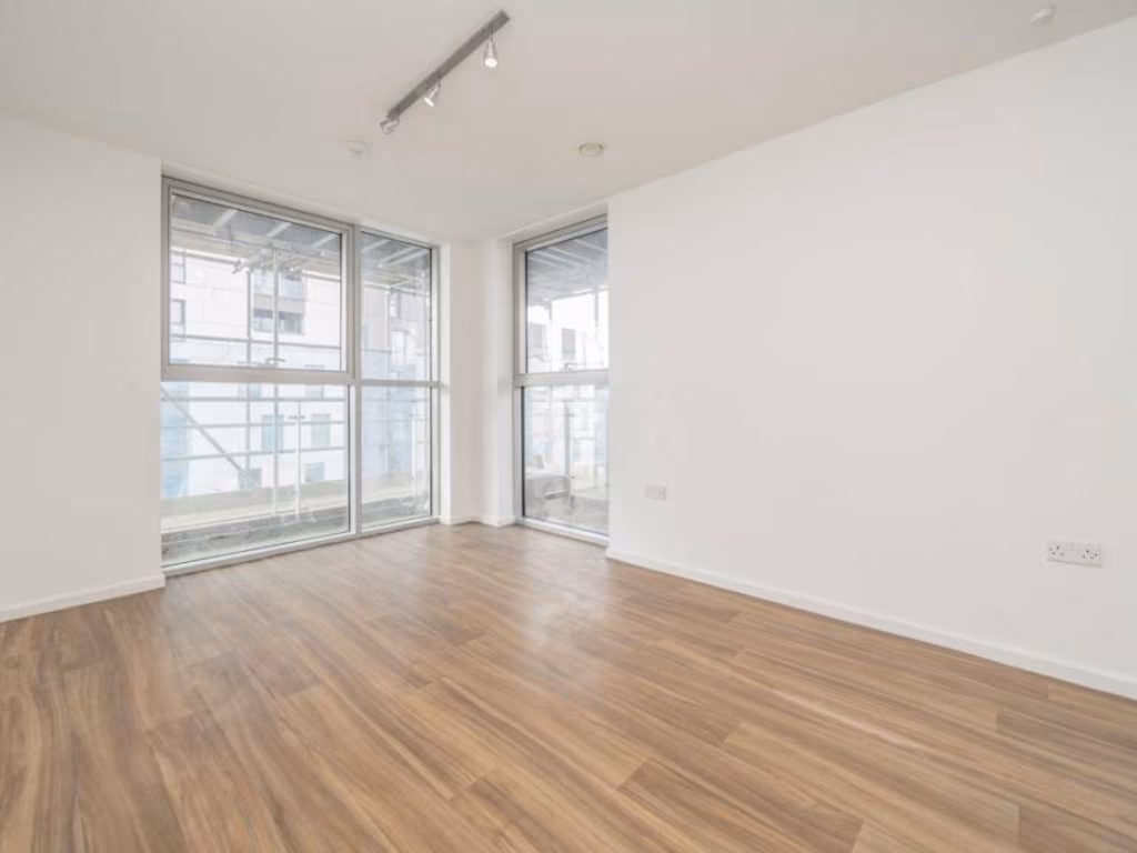
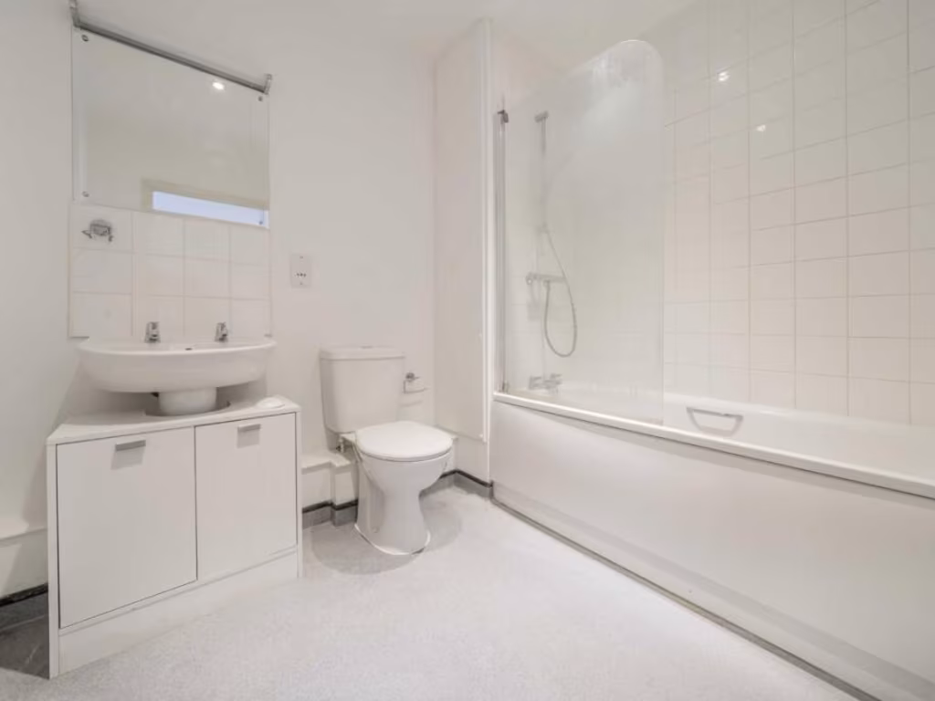
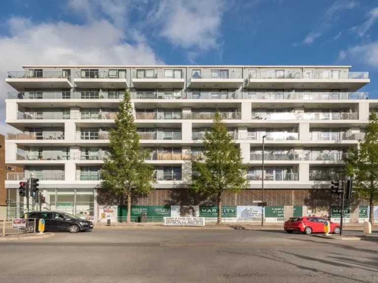
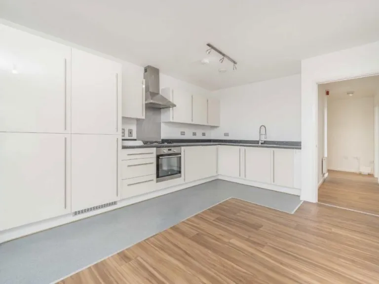
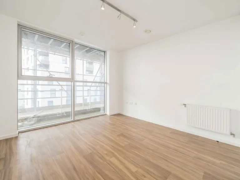
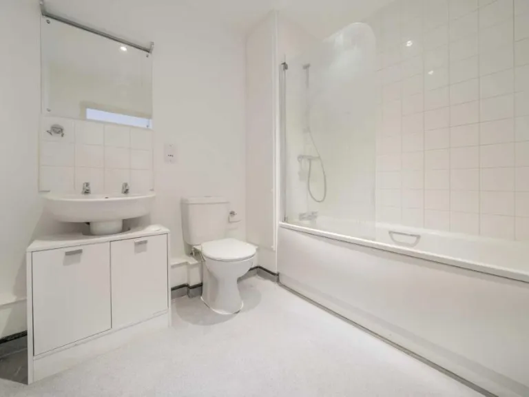
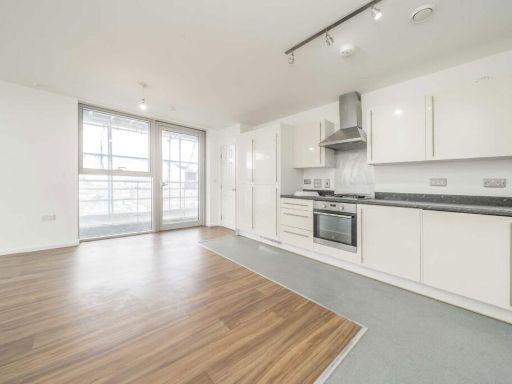
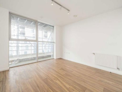
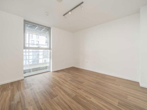
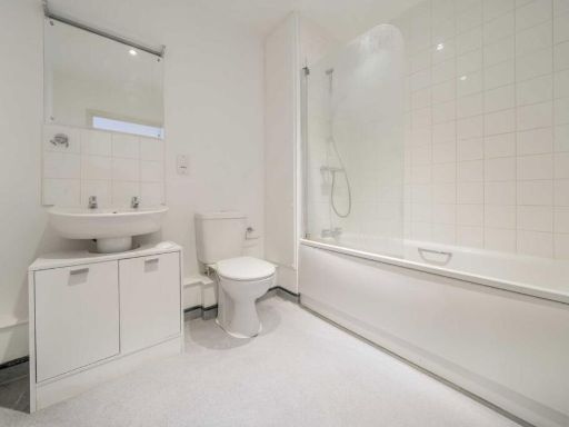
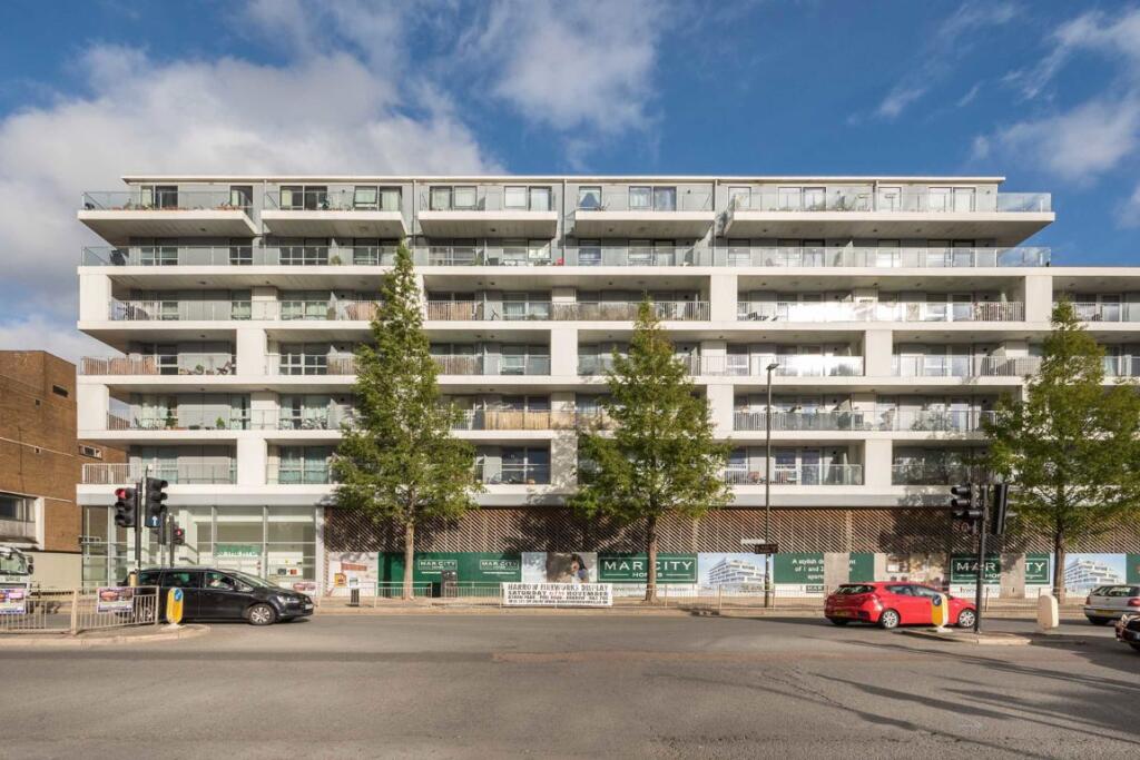
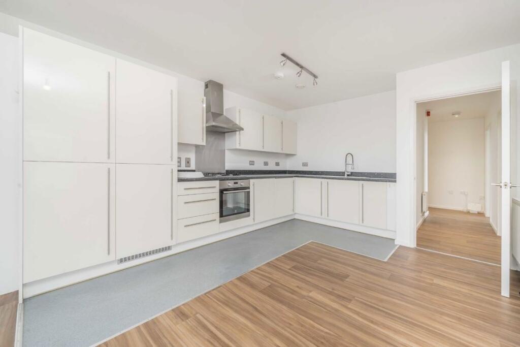
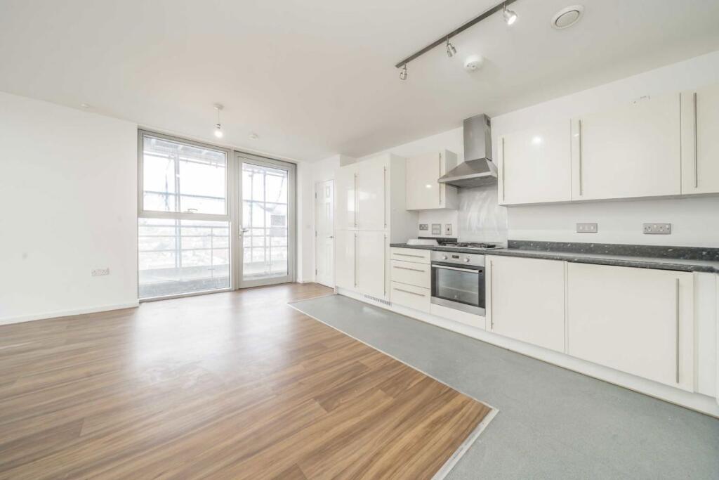
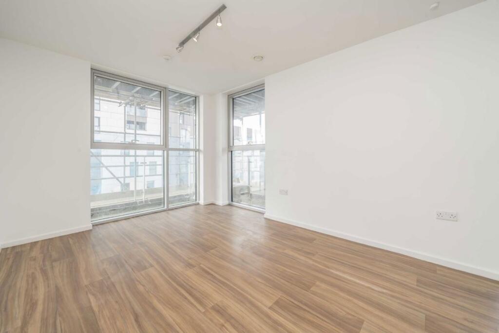
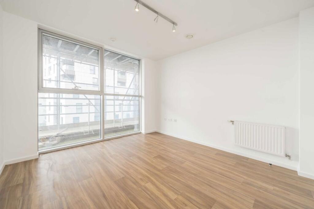
- Purpose-built two-bedroom apartment located on The Hyde (NW9). The property presents as an average-sized flat with an open-plan kitchen / reception room leading to a large, wrap‑around private balcony / terrace overlooking the street. Accommodation includes two double bedrooms and a single bathroom. Additional features listed include allocated parking, concierge services and communal entrance; the building is mid-rise with multiple balconies visible. The apartment appears modern with wood-effect flooring in the reception and a contemporary fitted kitchen. The outlook is urban (street) rather than exceptional (no sea/river/woodland view evident). Overall condition and specification appear good, suitable for an owner-occupier or buy-to-let investor seeking a well-located NW9 flat with outdoor space and parking.
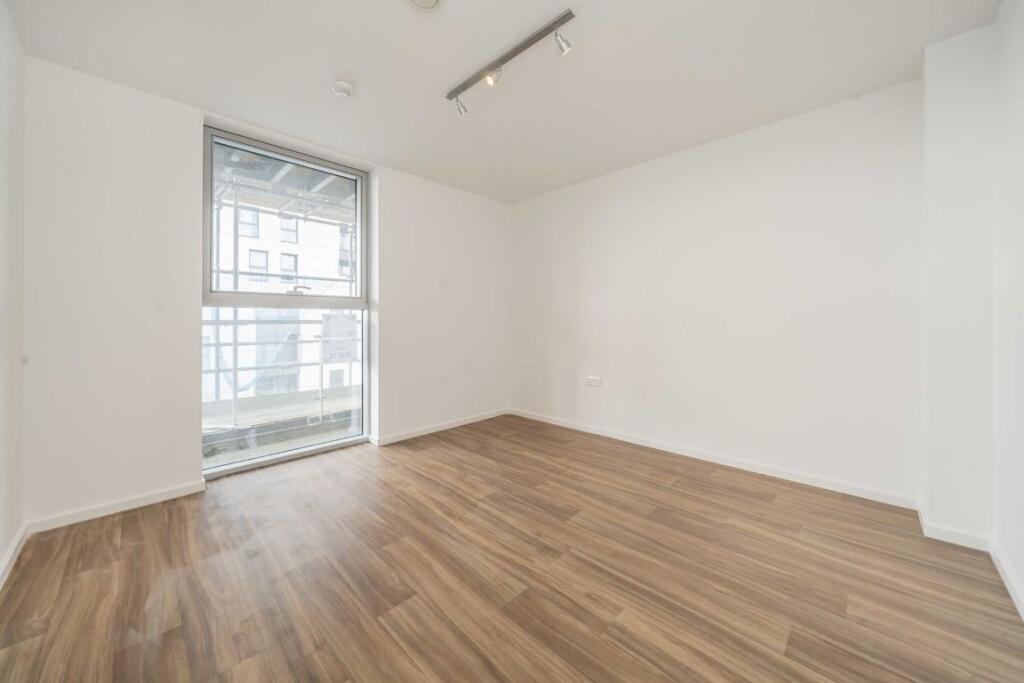
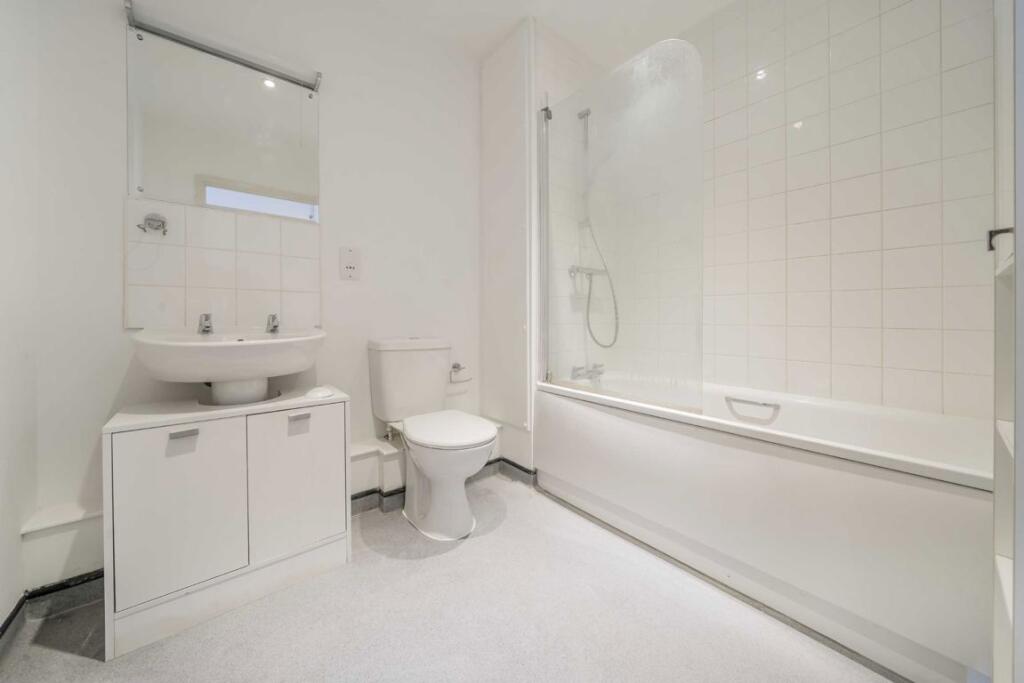
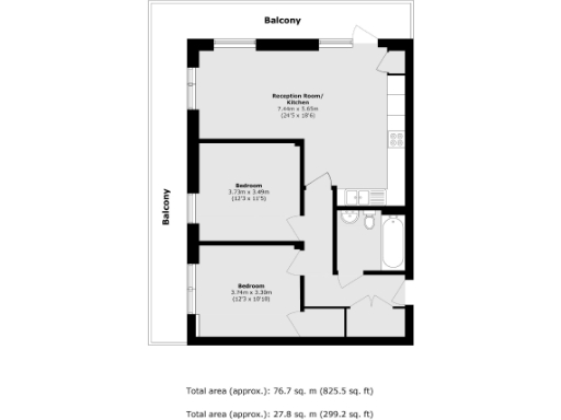
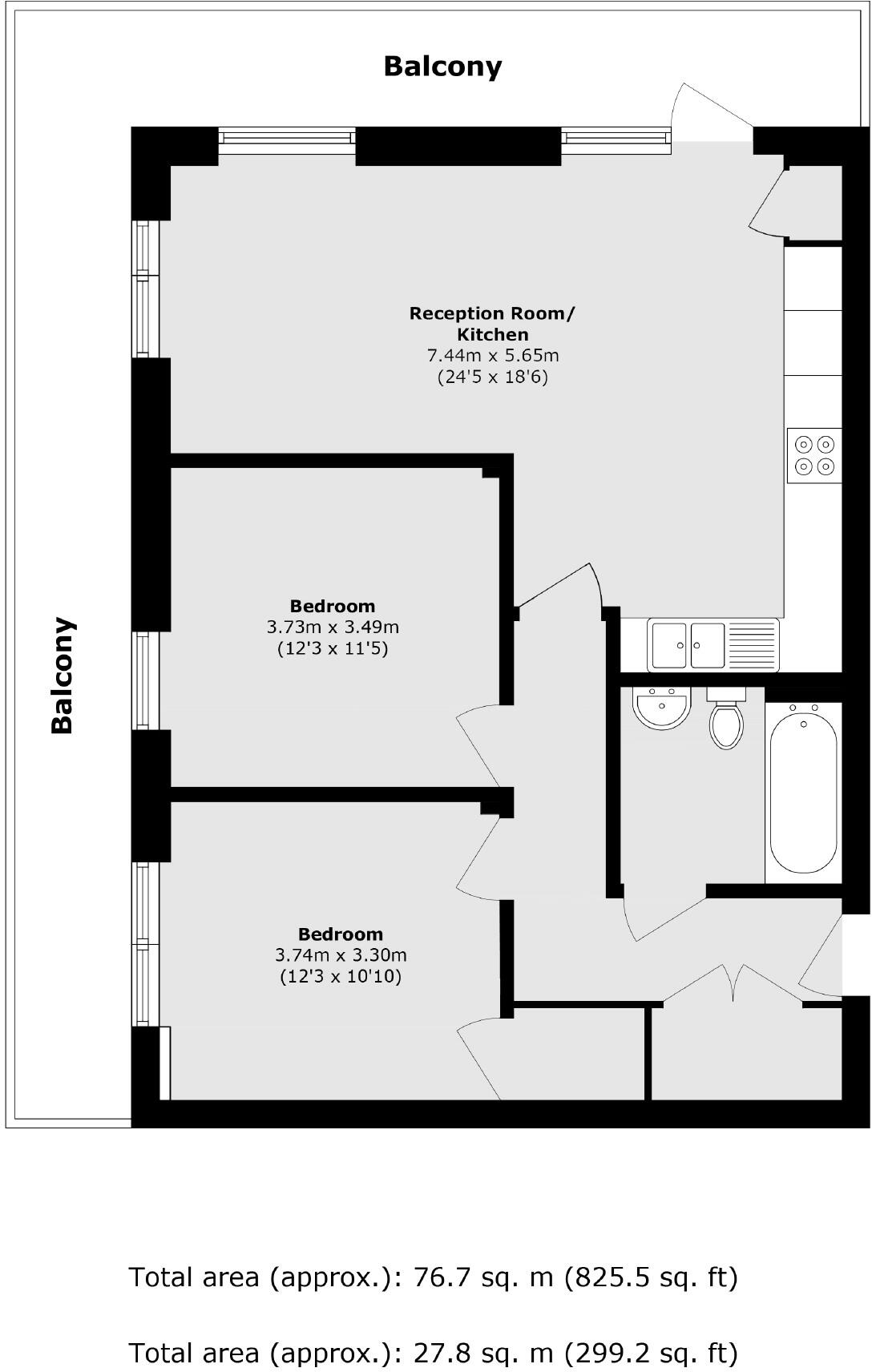
- Second-floor (floor level inferred from plan) two-bedroom apartment with large open-plan reception/kitchen and wrap-around balcony. The reception/kitchen measures approximately 7.44 m x 5.65 m (24'5" x 18'6") and benefits from direct access to a generous balcony that runs along two sides of the apartment. Two double bedrooms (approx. 3.73 m x 3.49 m and 3.74 m x 3.30 m) are served by a separate bathroom and a secondary WC/utility area adjacent to the entrance. The layout is practical with a central hallway providing good separation between living and sleeping spaces. The property is suited to buyers seeking a well-proportioned urban flat with substantial outdoor terrace space. Overall size is approximately 76.7 sq. m (825.5 sq. ft).
Image Descriptions
- apartment complex modern
- kitchen modern
Rooms
- Reception Room/ Kitchen:
- Bedroom:
- Bedroom:
Textual Property Features
Detected Visual Features
- modern apartment
- balcony
- urban location
- multi-story
- flats
- residential building
- modern kitchen
- integrated appliances
- laminate flooring
- neutral color scheme
- contemporary design
- light and airy
EPC Details
- Fully double glazed
- Cavity wall, as built, insulated (assumed)
- Boiler and radiators, mains gas
- Low energy lighting in all fixed outlets
- (another dwelling below)
Nearby Schools
- The Annunciation Catholic Infant School
- The Annunciation RC Junior School
- Greenacres Primary School and Language Impairment Unit
- Colindale Primary School
- The Orion Primary School
- Beis Yaakov Primary School
- Shalom Noam Primary School
- Goldbeaters Primary School
- Menorah Foundation School
- Woodcroft Primary School
- Deansbrook Junior School
- Saracens High School
- Fryent Primary School
- St Robert Southwell Catholic Primary School
- Bnos Beis Yaakov Primary School
- Kingsbury High School
- Barnfield Primary School
- Deansbrook Infant School
- The Hyde School
- Oliver Goldsmith Primary School
- Kingsbury Green Primary School
- Roe Green Infant School
- Roe Green Junior School
- Watling Park School
- Menorah Grammar School
Nearest Bars And Restaurants
- Id: 966872002
- Tags:
- Amenity: cafe
- Building: yes
- Building:levels: 1
- TagsNormalized:
- Lat: 51.5977168
- Lon: -0.2572163
- FullGeoHash: gcpvd1hdqrt9
- PartitionGeoHash: gcpv
- Images:
- FoodStandards: null
- Distance: 371
,- Id: 5022674221
- Tags:
- Amenity: restaurant
- Cuisine: turkish
- Name: Alkis
- Name:en: Alkis
- TagsNormalized:
- Lat: 51.5970842
- Lon: -0.2636536
- FullGeoHash: gcpvd0bnb3ts
- PartitionGeoHash: gcpv
- Images:
- FoodStandards: null
- Distance: 334.5
,- Id: 199925839
- Tags:
- Alt_name: Kentucky Fried Chicken
- Amenity: fast_food
- Brand: KFC
- Brand:wikidata: Q524757
- Brand:wikipedia: en:KFC
- Building: yes
- Contact:
- Website: https://www.kfc.co.uk/kfc-near-me/colindale-hyde
- Cuisine: chicken
- Drive_through: yes
- Name: KFC
- Outdoor_seating: yes
- Takeaway: yes
- TagsNormalized:
- fast food
- food
- kfc
- chicken
- drive through
- takeaway
- Lat: 51.5934374
- Lon: -0.2582829
- FullGeoHash: gcpvd07ct9f6
- PartitionGeoHash: gcpv
- Images:
- FoodStandards: null
- Distance: 215.9
,- Id: 675377879
- Tags:
- Amenity: food_court
- Building: yes
- Name: Bang Bang Oriental Food Hall
- TagsNormalized:
- Lat: 51.5931256
- Lon: -0.2599536
- FullGeoHash: gcpvd04xwxsw
- PartitionGeoHash: gcpv
- Images:
- FoodStandards: null
- Distance: 204.4
,- Id: 4313588507
- Tags:
- Amenity: cafe
- Operator: Morrisons
- TagsNormalized:
- Lat: 51.5935276
- Lon: -0.2598224
- FullGeoHash: gcpvd06f1dwk
- PartitionGeoHash: gcpv
- Images:
- FoodStandards: null
- Distance: 161.2
}
Nearest General Shops
- Id: 10281454555
- Tags:
- Brand: Wilko
- Brand:wikidata: Q8002536
- Name: Wilko
- Shop: variety_store
- TagsNormalized:
- Lat: 51.5945223
- Lon: -0.2622696
- FullGeoHash: gcpvd03pbsj9
- PartitionGeoHash: gcpv
- Images:
- FoodStandards: null
- Distance: 148.8
,- Id: 5022667831
- Tags:
- Name: Mercedes-Benz Colindale
- Name:en: Mercedes-Benz Colindale
- Shop: car
- TagsNormalized:
- Lat: 51.5955706
- Lon: -0.2620371
- FullGeoHash: gcpvd09jyp6z
- PartitionGeoHash: gcpv
- Images:
- FoodStandards: null
- Distance: 142.3
,- Id: 7495204935
- Tags:
- Brand: Asda
- Brand:wikidata: Q297410
- Brand:wikipedia: en:Asda
- Contact:
- Phone: +44 20 8358 2513
- Website: https://storelocator.asda.com/london/london/capitol-way-off-edgware-road-colindale/opticians
- Fixme: Location not accurate
- Operator: Asda Stores Ltd
- Shop: optician
- TagsNormalized:
- Lat: 51.5940153
- Lon: -0.2605015
- FullGeoHash: gcpvd06kcvs1
- PartitionGeoHash: gcpv
- Images:
- FoodStandards: null
- Distance: 106.2
}
Nearest Grocery shops
- Id: 451465911
- Tags:
- Building: retail
- Building:colour: white
- Building:levels: 2
- Name: Fine Foods
- Shop: convenience
- TagsNormalized:
- Lat: 51.5934136
- Lon: -0.2541172
- FullGeoHash: gcpvd0qcqtkk
- PartitionGeoHash: gcpv
- Images:
- FoodStandards: null
- Distance: 455.8
,- Id: 451465913
- Tags:
- Addr:
- City: London
- Housenumber: 27-29
- Postcode: NW9 5DS
- Street: Colindale Avenue
- Fhrs:
- Name: Home Store Food & Wine
- Shop: convenience
- Source:
- Addr:
- Housenumber: photo
- Postcode: FSA Food Hygiene Rating Scheme open data
- TagsNormalized:
- Lat: 51.593149
- Lon: -0.2555539
- FullGeoHash: gcpvd0jzvhj1
- PartitionGeoHash: gcpv
- Images:
- FoodStandards:
- Id: 757805
- FHRSID: 757805
- LocalAuthorityBusinessID: CP/41359
- BusinessName: Homestore Food & Wine
- BusinessType: Retailers - other
- BusinessTypeID: 4613
- AddressLine1: 27 Colindale Avenue, London
- AddressLine2: null
- AddressLine3: null
- AddressLine4: null
- PostCode: NW9 5DS
- RatingValue: 3
- RatingKey: fhrs_3_en-GB
- RatingDate: 2021-02-19
- LocalAuthorityCode: 502
- LocalAuthorityName: Barnet
- LocalAuthorityWebSite: http://www.barnet.gov.uk/
- LocalAuthorityEmailAddress: FoodSafety@barnet.gov.uk
- Scores:
- Hygiene: 10
- Structural: 5
- ConfidenceInManagement: 10
- NewRatingPending: false
- Geocode:
- Longitude: -0.25588100000000
- Latitude: 51.59312000000000
- Distance: 380.4
,- Id: 5022667928
- Tags:
- Name: Corner 4 News & Booze
- Name:en: Corner 4 News & Booze
- Shop: convenience
- TagsNormalized:
- Lat: 51.5970245
- Lon: -0.2635756
- FullGeoHash: gcpvd0bn6nrz
- PartitionGeoHash: gcpv
- Images:
- FoodStandards: null
- Distance: 326
}
Nearest Supermarkets
- Id: 10281454556
- Tags:
- Brand: ALDI
- Brand:wikidata: Q41171672
- Name: ALDI
- Shop: supermarket
- TagsNormalized:
- Lat: 51.5946819
- Lon: -0.262391
- FullGeoHash: gcpvd08bvcg1
- PartitionGeoHash: gcpv
- Images:
- FoodStandards: null
- Distance: 152.3
,- Id: 10281454554
- Tags:
- Brand: M&S Foodhall
- Brand:wikidata: Q714491
- Name: M&S Foodhall
- Shop: supermarket
- TagsNormalized:
- m&s foodhall
- supermarket
- shop
- Lat: 51.5943526
- Lon: -0.2621248
- FullGeoHash: gcpvd03nuh3t
- PartitionGeoHash: gcpv
- Images:
- FoodStandards: null
- Distance: 147
,- Id: 228952703
- Tags:
- Addr:
- City: Colindale
- Country: GB
- Housename: Capitol Industrial Park
- Postcode: NW9 0AS
- Street: Capitol Way
- Unit: 53
- Alt_name: ASDA Colindale Superstore
- Brand: Asda
- Brand:wikidata: Q297410
- Brand:wikipedia: en:Asda
- Building: retail
- Contact:
- Facebook: https://www.facebook.com/asda/
- Phone: +44 20 8200 4833
- Twitter: @asda
- Website: https://storelocator.asda.com/london/london/capitol-way-off-edgware-road-colindale
- Fhrs:
- Name: Asda
- Opening_hours: Mo 07:00-24:00; Tu-Fr 00:00-24:00; Sa 00:00-22:00; Su 11:00-17:00
- Opening_hours:url: http://storelocator.asda.com/store/colindale
- Operator: Asda Stores Ltd
- Shop: supermarket
- TagsNormalized:
- asda
- retail
- supermarket
- shop
- Lat: 51.5941032
- Lon: -0.2611865
- FullGeoHash: gcpvd03v3vvj
- PartitionGeoHash: gcpv
- Images:
- FoodStandards:
- Id: 533605
- FHRSID: 533605
- LocalAuthorityBusinessID: 7246
- BusinessName: Asda
- BusinessType: Retailers - supermarkets/hypermarkets
- BusinessTypeID: 7840
- AddressLine1: 53 Capitol Industrial Park
- AddressLine2: Capitol Way
- AddressLine3: London
- AddressLine4: null
- PostCode: NW9 0AS
- RatingValue: 5
- RatingKey: fhrs_5_en-GB
- RatingDate: 2022-10-07
- LocalAuthorityCode: 504
- LocalAuthorityName: Brent
- LocalAuthorityWebSite: http://www.brent.gov.uk/
- LocalAuthorityEmailAddress: ens.foodsafety@brent.gov.uk
- Scores:
- Hygiene: 5
- Structural: 5
- ConfidenceInManagement: 5
- NewRatingPending: false
- Geocode:
- Longitude: -0.26113200000000
- Latitude: 51.59399800000000
- Distance: 115.5
}
Nearest Religious buildings
- Id: 87212256
- Tags:
- Amenity: place_of_worship
- Denomination: roman_catholic
- Name: Our Lady of the Annunciation
- Religion: christian
- Source: OS_OpenData_StreetView;website
- Url: http://www.rcdow.org.uk/burntoak/
- TagsNormalized:
- place of worship
- catholic
- roman catholic
- christian
- church
- Lat: 51.6025181
- Lon: -0.2607097
- FullGeoHash: gcpvd1fnmn8f
- PartitionGeoHash: gcpv
- Images:
- FoodStandards: null
- Distance: 841.6
,- Id: 92873957
- Tags:
- Amenity: place_of_worship
- Building: church
- Denomination: catholic
- Name: Catholic Church of Ss. Sebastian & Pancras
- Phone: +44 20 8204 2834
- Religion: christian
- Service_times: Su 08:00,10:00,12:15,18:30;Mo,Tu,Fr 00:15;We,Th 09:15,19:30;Sa 09:15,18:30
- Source: OS_OpenData_StreetView;survey
- Survey:
- TagsNormalized:
- place of worship
- church
- catholic
- christian
- Lat: 51.5879209
- Lon: -0.2631779
- FullGeoHash: gcpv6p237t2q
- PartitionGeoHash: gcpv
- Images:
- FoodStandards: null
- Distance: 808.2
,- Id: 83341923
- Tags:
- Amenity: place_of_worship
- Denomination: anglican
- Name: St Alphage, Hendon
- Religion: christian
- Source: OS;web
- Wikidata: Q105099972
- TagsNormalized:
- place of worship
- anglican
- christian
- church
- Lat: 51.598555
- Lon: -0.2629065
- FullGeoHash: gcpvd10x3gf9
- PartitionGeoHash: gcpv
- Images:
- FoodStandards: null
- Distance: 440.9
}
Nearest Medical buildings
- Id: 200222435
- Tags:
- Amenity: clinic
- Building: yes
- Healthcare: clinic
- Name: Watling Medical Centre
- TagsNormalized:
- Lat: 51.6032982
- Lon: -0.2620218
- FullGeoHash: gcpvd415n2n2
- PartitionGeoHash: gcpv
- Images:
- FoodStandards: null
- Distance: 935.9
,- Id: 5777433435
- Tags:
- Amenity: dentist
- Healthcare: dentist
- Name: Care Dental
- TagsNormalized:
- dentist
- health
- healthcare
- dental
- Lat: 51.600183
- Lon: -0.2678422
- FullGeoHash: gcpv9csbyg63
- PartitionGeoHash: gcpv
- Images:
- FoodStandards: null
- Distance: 783.8
,- Id: 5971390531
- Tags:
- Amenity: doctors
- Healthcare: doctor
- Name: Willow Tree Family Doctors
- TagsNormalized:
- doctor
- doctors
- health
- healthcare
- Lat: 51.5896925
- Lon: -0.265583
- FullGeoHash: gcpv3zweerwy
- PartitionGeoHash: gcpv
- Images:
- FoodStandards: null
- Distance: 692.2
,- Id: 7495204936
- Tags:
- Amenity: pharmacy
- Brand: Asda
- Brand:wikidata: Q297410
- Brand:wikipedia: en:Asda
- Contact:
- Phone: +44 20 8200 4833
- Website: https://storelocator.asda.com/london/london/capitol-way-off-edgware-road-colindale/pharmacy
- Fixme: Location not accurate
- Operator: Asda Stores Ltd
- TagsNormalized:
- Lat: 51.594072
- Lon: -0.2603781
- FullGeoHash: gcpvd06mkb05
- PartitionGeoHash: gcpv
- Images:
- FoodStandards: null
- Distance: 98.7
}
Nearest Airports
- Id: 121158889
- Tags:
- Aerodrome: continental
- Aeroway: aerodrome
- Fhrs:
- Authority: City of London Corporation
- Iata: LCY
- Icao: EGLC
- Name: London City Airport
- Operator: London City Airport Limited
- Ref: LCY
- Website: https://www.londoncityairport.com/
- Wikidata: Q8982
- Wikipedia: en:London City Airport
- TagsNormalized:
- airport
- continental airport
- Lat: 51.5042658
- Lon: 0.0539987
- FullGeoHash: u10j10p64702
- PartitionGeoHash: u10j
- Images:
- FoodStandards: null
- Distance: 23953.5
,- Id: 14001268
- Tags:
- Access: yes
- Aerodrome: international
- Aerodrome:type: public
- Aeroway: aerodrome
- Alt_name: London Heathrow
- Alt_name_2: London Heathrow Airport
- Ele: 25
- Iata: LHR
- Icao: EGLL
- Int_name: Heathrow Airport
- Name: London Heathrow Airport
- Note: area still approx
- Old_name: London Airport
- Operator: Heathrow Airport Limited
- Rank_aci:
- Ref: LHR
- Short_name: Heathrow
- Type: multipolygon
- Website: https://www.heathrow.com/
- Wikidata: Q8691
- Wikipedia: en:Heathrow Airport
- TagsNormalized:
- airport
- international airport
- Lat: 51.4677522
- Lon: -0.4547736
- FullGeoHash: gcpsv9kv7h2h
- PartitionGeoHash: gcps
- Images:
- FoodStandards: null
- Distance: 19523.2
}
Nearest Leisure Facilities
- Id: 9925042518
- Tags:
- Fitness_station: horizontal_bar
- Leisure: fitness_station
- Sport: fitness
- Wheelchair: yes
- TagsNormalized:
- fitness
- fitness station
- station
- leisure
- sports
- Lat: 51.5923293
- Lon: -0.2621883
- FullGeoHash: gcpvd0154e60
- PartitionGeoHash: gcpv
- Images:
- FoodStandards: null
- Distance: 321.8
,- Id: 199098310
- Tags:
- TagsNormalized:
- Lat: 51.5928851
- Lon: -0.2574213
- FullGeoHash: gcpvd0hw3dug
- PartitionGeoHash: gcpv
- Images:
- FoodStandards: null
- Distance: 301.1
,- Id: 199925802
- Tags:
- TagsNormalized:
- Lat: 51.5954125
- Lon: -0.2566748
- FullGeoHash: gcpvd0tj5412
- PartitionGeoHash: gcpv
- Images:
- FoodStandards: null
- Distance: 250.9
,- Id: 374627772
- Tags:
- Leisure: pitch
- Sport: tennis
- TagsNormalized:
- Lat: 51.5959688
- Lon: -0.2576074
- FullGeoHash: gcpvd0u2m3dn
- PartitionGeoHash: gcpv
- Images:
- FoodStandards: null
- Distance: 213.4
,- Id: 374627771
- Tags:
- Leisure: pitch
- Sport: tennis
- TagsNormalized:
- Lat: 51.5958679
- Lon: -0.2577898
- FullGeoHash: gcpvd0sr9ncu
- PartitionGeoHash: gcpv
- Images:
- FoodStandards: null
- Distance: 196.8
}
Nearest Tourist attractions
- Id: 118906069
- Tags:
- Fee: no
- Museum: aerospace
- Name: RAF Museum
- Toilets:
- Tourism: museum
- Website: https://www.rafmuseum.org.uk/london
- Wheelchair: yes
- Wheelchair:description: Accessible toilets in each display area. Some exhibits have steps to cockpit viewing platform. Cafe has high counter. No Loop provision. No Loop/subtitles on Audiovisual displays/film clips.
- Wikidata: Q1890450
- Wikimedia_commons: File:Junkers_Ju_88_RAF_Hendon.jpg
- Wikipedia: en:Royal Air Force Museum London
- TagsNormalized:
- Lat: 51.5979854
- Lon: -0.2390705
- FullGeoHash: gcpvd91uj385
- PartitionGeoHash: gcpv
- Images:
- FoodStandards: null
- Distance: 1500
,- Id: 4480990844
- Tags:
- Alt_name: MODA
- Name: Museum of Domestic Design & Architecture
- Opening_hours: "by appointment"
- Operator: Middlesex University
- Tourism: museum
- Wikidata: Q119160
- TagsNormalized:
- Lat: 51.5960603
- Lon: -0.2414621
- FullGeoHash: gcpvd8b0vdbb
- PartitionGeoHash: gcpv
- Images:
- FoodStandards: null
- Distance: 1302.3
,- Id: 966871710
- Tags:
- TagsNormalized:
- Lat: 51.5999847
- Lon: -0.2613652
- FullGeoHash: gcpvd13xtwrf
- PartitionGeoHash: gcpv
- Images:
- FoodStandards: null
- Distance: 564.7
}
Nearest Hotels
- Id: 456080288
- Tags:
- Building: yes
- Tourism: hotel
- TagsNormalized:
- Lat: 51.584754
- Lon: -0.2825073
- FullGeoHash: gcpv3wdqcp57
- PartitionGeoHash: gcpv
- Images:
- FoodStandards: null
- Distance: 1911.8
,- Id: 478919288
- Tags:
- Addr:
- Housenumber: 435
- Postcode: HA8 5AQ
- Street: Burnt Oak Broadway
- Brand: Premier Inn
- Brand:wikidata: Q2108626
- Brand:wikipedia: en:Premier Inn
- Building: yes
- Contact:
- Website: https://www.premierinn.com/gb/en/hotels/england/greater-london/london/london-edgware.html
- Internet_access: wlan
- Internet_access:fee: customers
- Internet_access:operator: Virgin Media
- Internet_access:ssid: Premier Inn Free Wi-Fi
- Name: Premier Inn London Edgware
- Tourism: hotel
- TagsNormalized:
- Lat: 51.6080992
- Lon: -0.2767709
- FullGeoHash: gcpv9dyqyybx
- PartitionGeoHash: gcpv
- Images:
- FoodStandards: null
- Distance: 1855
,- Id: 5527974518
- Tags:
- Addr:
- City: London
- Housename: Hyde House
- Postcode: NW9 6LH
- Street: The Hyde
- Brand: Premier Inn
- Brand:wikidata: Q2108626
- Brand:wikipedia: en:Premier Inn
- Fhrs:
- Authority: Barnet
- Id: 758451
- Local_authority_id: CP/60794
- Internet_access: wlan
- Internet_access:fee: customers
- Internet_access:operator: Virgin Media
- Internet_access:ssid: Premier Inn Free Wi-Fi
- Name: Premier Inn
- Tourism: hotel
- TagsNormalized:
- Lat: 51.5850388
- Lon: -0.2482135
- FullGeoHash: gcpv6qg28hnw
- PartitionGeoHash: gcpv
- Images:
- FoodStandards: null
- Distance: 1380.3
}
Tags
- modern apartment
- balcony
- urban location
- multi-story
- flats
- residential building
- modern kitchen
- integrated appliances
- laminate flooring
- neutral color scheme
- contemporary design
- light and airy
Local Market Stats
- Average Price/sqft: £551
- Avg Income: £54100
- Rental Yield: 5.2%
- Social Housing: 17%
- Planning Success Rate: 74%
AirBnB Data
- 1km average: £100/night
- Listings in 1km: 14
Similar Properties
 1 bedroom flat for sale in The Hyde, London, NW9 — £290,000 • 1 bed • 1 bath • 615 ft²
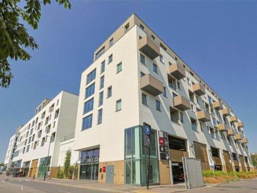 2 bedroom apartment for sale in Capitol Way, London, NW9 — £370,000 • 2 bed • 2 bath • 700 ft²
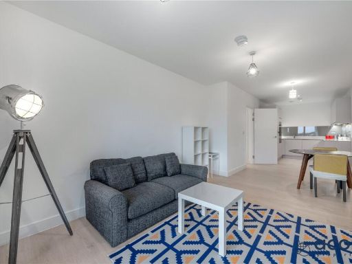 2 bedroom apartment for sale in Eastern Point, Edgware Road, NW9 — £415,000 • 2 bed • 2 bath • 828 ft²
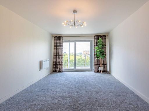 2 bedroom flat for sale in Heritage Avenue, Colindale, London, NW9 — £475,000 • 2 bed • 2 bath • 792 ft²
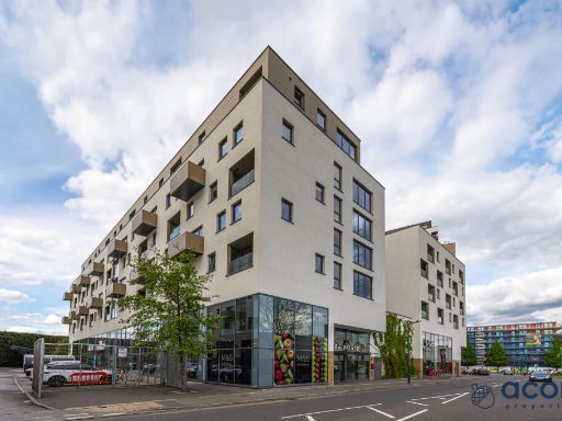 2 bedroom apartment for sale in Cara House, Capitol Way, London, NW9 — £375,000 • 2 bed • 2 bath • 646 ft²
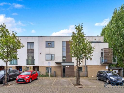 1 bedroom apartment for sale in Airco Close, London, NW9 — £285,000 • 1 bed • 1 bath • 519 ft²
Meta
- {
"@context": "https://schema.org",
"@type": "Residence",
"name": "2 bedroom flat for sale in The Hyde, London, NW9",
"description": "",
"url": "https://propertypiper.co.uk/property/6975424f-2703-4f53-b56b-65f14ff2a0e7",
"image": "https://image-a.propertypiper.co.uk/6f4a55ce-1130-4898-9129-bb8bed6437e6-1024.jpeg",
"address": {
"@type": "PostalAddress",
"streetAddress": "Flat 32, Mar House, 50 The Hyde",
"postalCode": "NW9 5NG",
"addressLocality": "Brent",
"addressRegion": "Hendon",
"addressCountry": "England"
},
"geo": {
"@type": "GeoCoordinates",
"latitude": 51.59495528342635,
"longitude": -0.2602312314085606
},
"numberOfRooms": 2,
"numberOfBathroomsTotal": 1,
"floorSize": {
"@type": "QuantitativeValue",
"value": 825,
"unitCode": "FTK"
},
"offers": {
"@type": "Offer",
"price": 375000,
"priceCurrency": "GBP",
"availability": "https://schema.org/InStock"
},
"additionalProperty": [
{
"@type": "PropertyValue",
"name": "Feature",
"value": "modern apartment"
},
{
"@type": "PropertyValue",
"name": "Feature",
"value": "balcony"
},
{
"@type": "PropertyValue",
"name": "Feature",
"value": "urban location"
},
{
"@type": "PropertyValue",
"name": "Feature",
"value": "multi-story"
},
{
"@type": "PropertyValue",
"name": "Feature",
"value": "flats"
},
{
"@type": "PropertyValue",
"name": "Feature",
"value": "residential building"
},
{
"@type": "PropertyValue",
"name": "Feature",
"value": "modern kitchen"
},
{
"@type": "PropertyValue",
"name": "Feature",
"value": "integrated appliances"
},
{
"@type": "PropertyValue",
"name": "Feature",
"value": "laminate flooring"
},
{
"@type": "PropertyValue",
"name": "Feature",
"value": "neutral color scheme"
},
{
"@type": "PropertyValue",
"name": "Feature",
"value": "contemporary design"
},
{
"@type": "PropertyValue",
"name": "Feature",
"value": "light and airy"
}
]
}
High Res Floorplan Images
Compatible Floorplan Images
FloorplanImages Thumbnail