LE16 9HW - Property for sale in Compass Point, Market Harborough, Leic…
View on Property Piper
Property for sale in Compass Point, Market Harborough, Leicestershire, LE16
Property Details
- Price: £1
- Bedrooms: 1
- Bathrooms: 1
- Property Type: undefined
- Property SubType: undefined
Brochure Descriptions
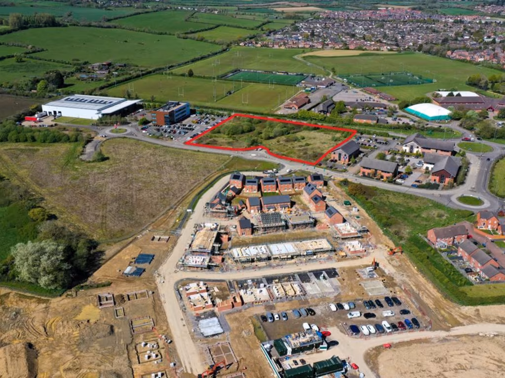
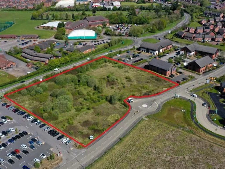
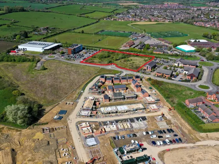
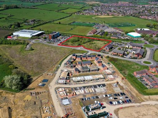
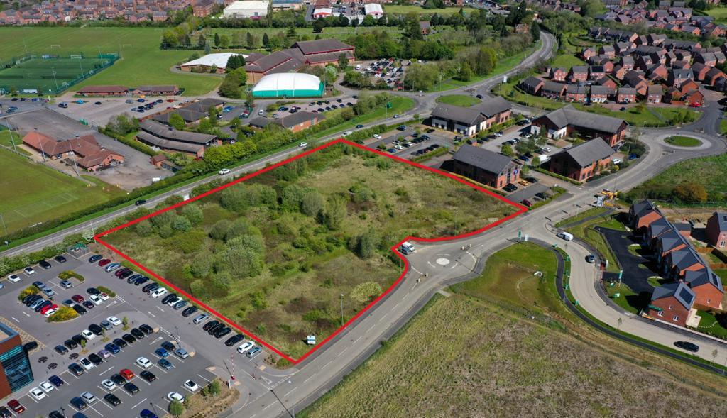
- The property is a substantial plot of land situated at Compass Point in Market Harborough, offering a development opportunity. The area appears to be urban with residential neighborhoods nearby, and includes views of community sports fields. The land itself is undeveloped, presenting a flat, grassy terrain bordered by roads on multiple sides. The plot size is large, suitable for significant residential or commercial development.
Image Descriptions
- vacant land undeveloped
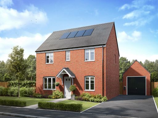
- aerial view of a housing development contemporary
Textual Property Features
Detected Visual Features
- vacant land
- undeveloped
- investment opportunity
- large plot
- development potential
- new development
- modern housing
- construction site
- residential area
- development plot
- future homes
Nearby Schools
- Montsaye Academy
- Welland Park Academy
- Lubenham All Saints Church of England Primary School
- Meadowdale Primary School
- Brooke House College
- The Robert Smyth Academy
- Ridgeway Primary Academy
- Loatlands Primary School
- Little Bowden School
- St Joseph's Catholic Voluntary Academy
- Kibworth Mead Academy
- Great Bowden Academy, A Church of England Primary School
- Naseby Church of England Primary Academy
- Clipston Endowed Voluntary Controlled Primary School
- Havelock Junior School
- Havelock Infant School
- Farndon Fields Primary School
- Market Harborough Church of England Academy
- Wilbarston Church of England Primary School
- Church Langton Church of England Primary School
Nearest General Shops
- Id: 7639794610
- Tags:
- Name: Studio 51
- Shop: hairdresser
- TagsNormalized:
- Lat: 52.4702155
- Lon: -0.926844
- FullGeoHash: gcr66zvj4vp5
- PartitionGeoHash: gcr6
- Images:
- FoodStandards: null
- Distance: 1027
,- Id: 7639794612
- Tags:
- TagsNormalized:
- Lat: 52.4702138
- Lon: -0.9265061
- FullGeoHash: gcr66zvm4ufc
- PartitionGeoHash: gcr6
- Images:
- FoodStandards: null
- Distance: 1008.3
,- Id: 7639794617
- Tags:
- Addr:
- City: Market Harborough
- Country: GB
- Housenumber: 90
- Postcode: LE16 9HF
- Street: Northampton Road
- Fhrs:
- Authority: Harborough
- Id: 355426
- Local_authority_id: 11610/0090/2/000
- Name: J R Stores
- Shop: newsagent
- TagsNormalized:
- Lat: 52.4730878
- Lon: -0.9172243
- FullGeoHash: gcr6e0kjghec
- PartitionGeoHash: gcr6
- Images:
- FoodStandards:
- Id: 355426
- FHRSID: 355426
- LocalAuthorityBusinessID: 11610/0090/2/000
- BusinessName: J R Stores
- BusinessType: Retailers - other
- BusinessTypeID: 4613
- AddressLine1: Post Office
- AddressLine2: 90 Northampton Road
- AddressLine3: Market Harborough
- AddressLine4: Leics
- PostCode: LE16 9HF
- RatingValue: 4
- RatingKey: fhrs_4_en-GB
- RatingDate: 2017-01-30
- LocalAuthorityCode: 211
- LocalAuthorityName: Harborough
- LocalAuthorityWebSite: http://www.harborough.gov.uk
- LocalAuthorityEmailAddress: foodandsafety@harborough.gov.uk
- Scores:
- Hygiene: 5
- Structural: 10
- ConfidenceInManagement: 5
- NewRatingPending: false
- Geocode:
- Longitude: -0.91348600000000
- Latitude: 52.46826900000000
- Distance: 929.1
}
Nearest Religious buildings
- Id: 817357227
- Tags:
- Addr:
- City: Market Harborough
- Country: GB
- Postcode: LE16 8AS
- Street: Rectory Lane
- Amenity: community_centre
- Name: St Nicholas Church Hall
- TagsNormalized:
- community centre
- church
- church hall
- Lat: 52.474305
- Lon: -0.9113382
- FullGeoHash: gcr6e28kur2y
- PartitionGeoHash: gcr6
- Images:
- FoodStandards: null
- Distance: 1066
,- Id: 779967081
- Tags:
- Amenity: place_of_worship
- Building: church
- Denomination: anglican
- Name: St Hugh
- Religion: christian
- Wikidata: Q105079702
- TagsNormalized:
- place of worship
- church
- anglican
- christian
- Lat: 52.4722198
- Lon: -0.9167327
- FullGeoHash: gcr6e0k2yddx
- PartitionGeoHash: gcr6
- Images:
- FoodStandards: null
- Distance: 828
,- Id: 7639794615
- Tags:
- Addr:
- City: Market Harborough
- Country: GB
- Housenumber: 121
- Postcode: LE16 9JL
- Street: Bath Street
- Amenity: place_of_worship
- Fhrs:
- Authority: Harborough
- Id: 354860
- Local_authority_id: 00990/0121/2/000
- Name: Harborough Community Church
- Religion: christian
- TagsNormalized:
- place of worship
- church
- christian
- Lat: 52.4705145
- Lon: -0.9223688
- FullGeoHash: gcr67pbqghzf
- PartitionGeoHash: gcr6
- Images:
- FoodStandards:
- Id: 354860
- FHRSID: 354860
- LocalAuthorityBusinessID: 00990/0121/2/000
- BusinessName: Coffee \& Cake Dept
- BusinessType: Other catering premises
- BusinessTypeID: 7841
- AddressLine1: Harborough Community Church
- AddressLine2: 121 Bath Street
- AddressLine3: Market Harborough
- AddressLine4: Leicestershire
- PostCode: LE16 9JL
- RatingValue: 5
- RatingKey: fhrs_5_en-GB
- RatingDate: 2021-12-06
- LocalAuthorityCode: 211
- LocalAuthorityName: Harborough
- LocalAuthorityWebSite: http://www.harborough.gov.uk
- LocalAuthorityEmailAddress: foodandsafety@harborough.gov.uk
- Scores:
- Hygiene: 0
- Structural: 0
- ConfidenceInManagement: 5
- NewRatingPending: false
- Geocode:
- Longitude: -0.92234020000000
- Latitude: 52.47051530000000
- Distance: 823.1
}
Nearest Tourist attractions
- Id: 7627120535
- Tags:
- Addr:
- City: Market Harborough
- Country: GB
- Housename: Three Manors Retail Park
- Postcode: LE16 7BA
- Street: Rockingham Road
- Unit: Unit 6
- Fhrs:
- Authority: Harborough
- Id: 579641
- Local_authority_id: 13/00065/FOODHS
- Name: Mini Mischiefs
- Tourism: theme_park
- TagsNormalized:
- Lat: 52.4800751
- Lon: -0.9034807
- FullGeoHash: gcr6e3wne75f
- PartitionGeoHash: gcr6
- Images:
- FoodStandards:
- Id: 579641
- FHRSID: 579641
- LocalAuthorityBusinessID: 13/00065/FOODHS
- BusinessName: Mini Mischiefs
- BusinessType: Restaurant/Cafe/Canteen
- BusinessTypeID: 1
- AddressLine1: Unit 6
- AddressLine2: Three Manors Retail Park
- AddressLine3: Rockingham Road
- AddressLine4: Market Harborough
- PostCode: LE16 7BA
- RatingValue: 5
- RatingKey: fhrs_5_en-GB
- RatingDate: 2018-07-09
- LocalAuthorityCode: 211
- LocalAuthorityName: Harborough
- LocalAuthorityWebSite: http://www.harborough.gov.uk
- LocalAuthorityEmailAddress: foodandsafety@harborough.gov.uk
- Scores:
- Hygiene: 5
- Structural: 5
- ConfidenceInManagement: 5
- NewRatingPending: false
- Geocode:
- Longitude: -0.92648800000000
- Latitude: 52.48325800000000
- Distance: 1842.8
,- Id: 2929160455
- Tags:
- Addr:
- City: Market Harborough
- Housename: The Symington Building
- Postcode: LE16 7LT
- Street: Adam and Eve Street
- Museum: history
- Name: Harborough Museum
- Phone: +44 116 305 3627
- Tourism: museum
- Wikidata: Q5654740
- Wikipedia: en:Harborough Museum
- TagsNormalized:
- Lat: 52.4787159
- Lon: -0.9204808
- FullGeoHash: gcr6e13wxjxy
- PartitionGeoHash: gcr6
- Images:
- FoodStandards: null
- Distance: 1589.2
,- Id: 391874135
- Tags:
- Name: Gracelands Park
- Tourism: caravan_site
- TagsNormalized:
- Lat: 52.4716664
- Lon: -0.933883
- FullGeoHash: gcr6d8pvwgw6
- PartitionGeoHash: gcr6
- Images:
- FoodStandards: null
- Distance: 1516.6
}
Nearest Train stations
- Id: 456315214
- Tags:
- Name: Pitsford and Brampton
- Public_transport: station
- Railway: station
- Tourism: preserved_railway
- Usage: tourism
- Wikidata: Q7199048
- TagsNormalized:
- Lat: 52.2937192
- Lon: -0.9238379
- FullGeoHash: gcr36zz2cpb9
- PartitionGeoHash: gcr3
- Images:
- FoodStandards: null
- Distance: 19045.8
,- Id: 1372782830
- Tags:
- Name: Wicksteed Park
- Network: Wicksteed Park Railway
- Public_transport: station
- Railway: station
- Tourism: narrow_gauge_railway
- Train: yes
- Usage: tourism
- Wheelchair: yes
- TagsNormalized:
- station
- railway
- tourism
- train
- Lat: 52.3846758
- Lon: -0.7076312
- FullGeoHash: gcr6pbkdygrg
- PartitionGeoHash: gcr6
- Images:
- FoodStandards: null
- Distance: 16620.2
,- Id: 7156655363
- Tags:
- Name: Corby
- Naptan:
- Network: National Rail
- Operator: East Midlands Railway
- Public_transport: station
- Railway: station
- Ref:
- Train: yes
- Wikidata: Q5169828
- Wikimedia_commons: Category:Corby railway station
- Wikipedia: en:Corby railway station
- TagsNormalized:
- Lat: 52.4888488
- Lon: -0.6883829
- FullGeoHash: gcrd8769xw8e
- PartitionGeoHash: gcrd
- Images:
- FoodStandards: null
- Distance: 15539.7
,- Id: 3469981
- Tags:
- Name: Kettering
- Naptan:
- Network: National Rail
- Public_transport: station
- Railway: station
- Ref:
- Train: yes
- Wheelchair: yes
- Wikidata: Q2284587
- Wikimedia_commons: Category:Kettering railway station
- Wikipedia: en:Kettering railway station
- TagsNormalized:
- Lat: 52.3934872
- Lon: -0.7320452
- FullGeoHash: gcr6p3fynjgt
- PartitionGeoHash: gcr6
- Images:
- FoodStandards: null
- Distance: 14696.6
,- Id: 7153736020
- Tags:
- Name: Market Harborough
- Naptan:
- Network: National Rail
- Public_transport: station
- Railway: station
- Ref:
- Wikidata: Q2682713
- Wikimedia_commons: Category:Market Harborough railway station
- Wikipedia: en:Market Harborough railway station
- TagsNormalized:
- Lat: 52.4802412
- Lon: -0.9091337
- FullGeoHash: gcr6e39zxdhb
- PartitionGeoHash: gcr6
- Images:
- FoodStandards: null
- Distance: 1742.6
}
Nearest Hotels
- Id: 7626997832
- Tags:
- Addr:
- City: Market Harborough
- Country: GB
- Housenumber: 37
- Postcode: LE16 7AF
- Street: High Street
- Fhrs:
- Authority: Harborough
- Id: 355109
- Local_authority_id: 07060/0037/2/000
- Name: The Angel Hotel
- Tourism: hotel
- TagsNormalized:
- Lat: 52.4801854
- Lon: -0.9236763
- FullGeoHash: gcr6dcxrhz95
- PartitionGeoHash: gcr6
- Images:
- FoodStandards: null
- Distance: 1810.6
,- Id: 7636464862
- Tags:
- Addr:
- City: Market Harborough
- Country: GB
- Housenumber: 6
- Postcode: LE16 9AA
- Street: Abbey Street
- Brand: Travelodge
- Brand:wikidata: Q9361374
- Brand:wikipedia: en:Travelodge UK
- Fhrs:
- Authority: Harborough
- Id: 355388
- Local_authority_id: 11/00033/FOODHS
- Internet_access: wlan
- Internet_access:fee: customers
- Internet_access:ssid: Travelodge WiFi
- Name: Travelodge
- Tourism: hotel
- TagsNormalized:
- Lat: 52.4794601
- Lon: -0.9237032
- FullGeoHash: gcr6dcx7h0kv
- PartitionGeoHash: gcr6
- Images:
- FoodStandards: null
- Distance: 1735.8
,- Id: 49789743
- Tags:
- Addr:
- City: Market Harborough
- Country: GB
- Housenumber: 21
- Postcode: LE16 7NJ
- Street: High Street
- Amenity: pub
- Building: yes
- Fhrs:
- Authority: Harborough
- Id: 355107
- Local_authority_id: 07060/0021/2/000
- Name: Three Swans Hotel
- Source:
- Toilets:
- Wheelchair: yes
- Wikidata: Q17539521
- TagsNormalized:
- Lat: 52.4791084
- Lon: -0.9231092
- FullGeoHash: gcr6dcxbcyzg
- PartitionGeoHash: gcr6
- Images:
- FoodStandards: null
- Distance: 1684.9
}
Tags
- vacant land
- undeveloped
- investment opportunity
- large plot
- development potential
- new development
- modern housing
- construction site
- residential area
- development plot
- future homes
- investment opportunity
Local Market Stats
- Average Price/sqft: £312
- Avg Income: £45500
- Rental Yield: 3.5%
- Social Housing: 7%
- Planning Success Rate: 91%
Similar Properties
 4 bedroom detached house for sale in Compass Point, Northampton Road, Market Harborough, Leicestershire,
LE16 9HW, LE16 — £437,950 • 4 bed • 1 bath • 431 ft²
4 bedroom detached house for sale in Compass Point, Northampton Road, Market Harborough, Leicestershire,
LE16 9HW, LE16 — £437,950 • 4 bed • 1 bath • 431 ft²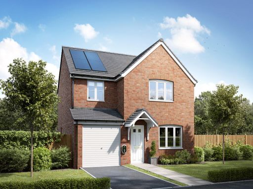 4 bedroom detached house for sale in Compass Point, Northampton Road, Market Harborough, Leicestershire,
LE16 9HW, LE16 — £404,950 • 4 bed • 1 bath • 815 ft²
4 bedroom detached house for sale in Compass Point, Northampton Road, Market Harborough, Leicestershire,
LE16 9HW, LE16 — £404,950 • 4 bed • 1 bath • 815 ft²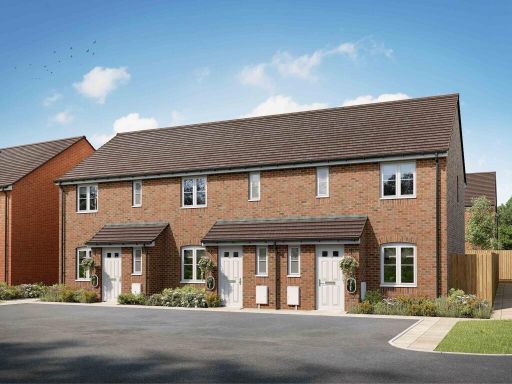 3 bedroom terraced house for sale in Compass Point, Northampton Road, Market Harborough, Leicestershire,
LE16 9HW, LE16 — £279,950 • 3 bed • 1 bath • 309 ft²
3 bedroom terraced house for sale in Compass Point, Northampton Road, Market Harborough, Leicestershire,
LE16 9HW, LE16 — £279,950 • 3 bed • 1 bath • 309 ft²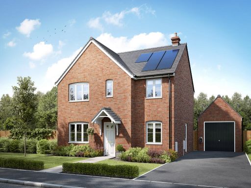 5 bedroom detached house for sale in Compass Point, Northampton Road, Market Harborough, Leicestershire,
LE16 9HW, LE16 — £474,950 • 5 bed • 1 bath • 566 ft²
5 bedroom detached house for sale in Compass Point, Northampton Road, Market Harborough, Leicestershire,
LE16 9HW, LE16 — £474,950 • 5 bed • 1 bath • 566 ft²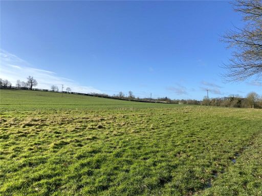 Land for sale in Lot 2, Gumley, Leicestershire, LE16 — £735,000 • 1 bed • 1 bath
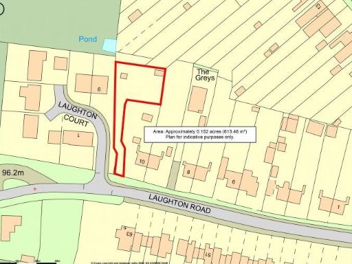 Plot for sale in Development Opportunity to the rear of Laughton Road, Lubenham, Market Harborough, LE16 — £275,000 • 1 bed • 1 bath • 6598 ft²
Meta
- {
"@context": "https://schema.org",
"@type": "Residence",
"name": "Property for sale in Compass Point, Market Harborough, Leic…",
"description": "",
"url": "https://propertypiper.co.uk/property/61f47d89-eff5-42ca-bb1e-7357e92c7cfa",
"image": "https://image-a.propertypiper.co.uk/7bcdd681-a564-47af-9fc4-3100af8b2f50-1024.jpeg",
"address": {
"@type": "PostalAddress",
"streetAddress": "ENTERPRISE CENTRE, COMPASS POINT",
"postalCode": "LE16 9HW",
"addressLocality": "Harborough",
"addressRegion": "Harborough",
"addressCountry": "England"
},
"geo": {
"@type": "GeoCoordinates",
"latitude": 52.46490597856865,
"longitude": -0.9144380938288919
},
"numberOfRooms": 1,
"numberOfBathroomsTotal": 1,
"offers": {
"@type": "Offer",
"price": 1,
"priceCurrency": "GBP",
"availability": "https://schema.org/InStock"
},
"additionalProperty": [
{
"@type": "PropertyValue",
"name": "Feature",
"value": "vacant land"
},
{
"@type": "PropertyValue",
"name": "Feature",
"value": "undeveloped"
},
{
"@type": "PropertyValue",
"name": "Feature",
"value": "investment opportunity"
},
{
"@type": "PropertyValue",
"name": "Feature",
"value": "large plot"
},
{
"@type": "PropertyValue",
"name": "Feature",
"value": "development potential"
},
{
"@type": "PropertyValue",
"name": "Feature",
"value": "new development"
},
{
"@type": "PropertyValue",
"name": "Feature",
"value": "modern housing"
},
{
"@type": "PropertyValue",
"name": "Feature",
"value": "construction site"
},
{
"@type": "PropertyValue",
"name": "Feature",
"value": "residential area"
},
{
"@type": "PropertyValue",
"name": "Feature",
"value": "development plot"
},
{
"@type": "PropertyValue",
"name": "Feature",
"value": "future homes"
},
{
"@type": "PropertyValue",
"name": "Feature",
"value": "investment opportunity"
}
]
}