CM7 5BJ - 4 bedroom detached house for sale in Panfield Road, Bocking…
View on Property Piper
4 bedroom detached house for sale in Panfield Road,
Bocking,
Braintree,
CM7 5BJ, CM7
Property Details
- Price: £585000
- Bedrooms: 4
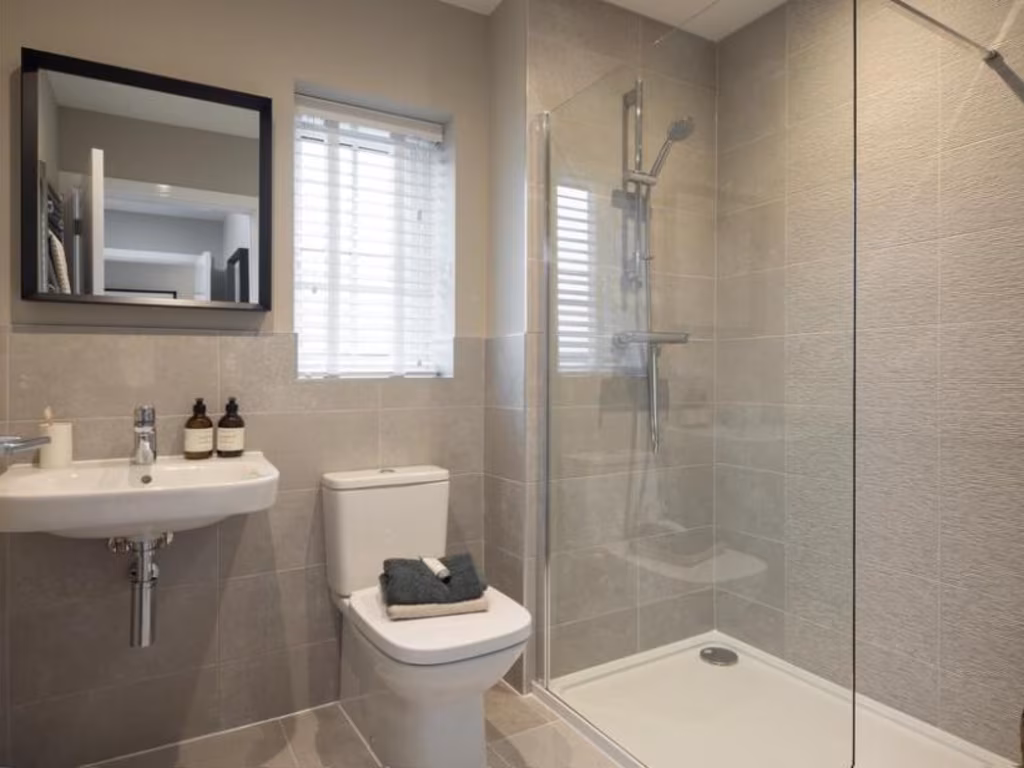
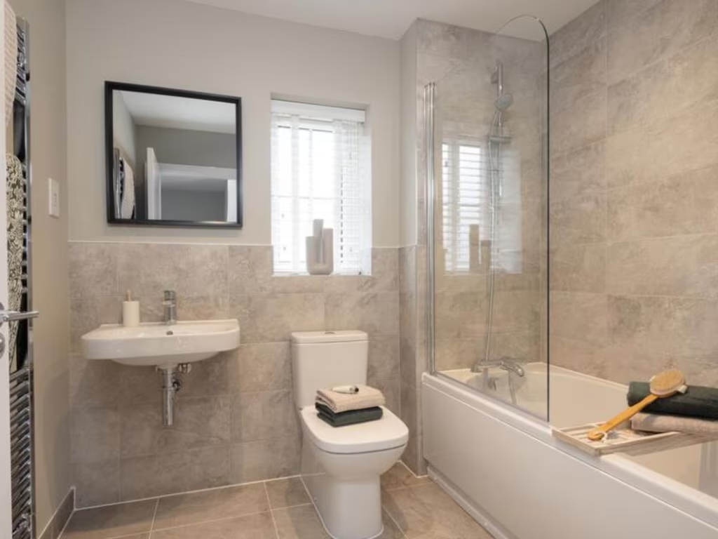
- Bathrooms: 1
- Property Type: undefined
- Property SubType: undefined
Image Descriptions
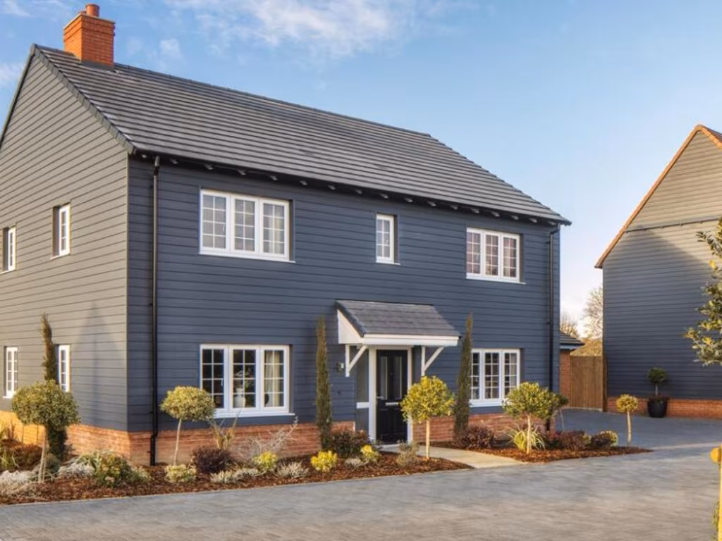
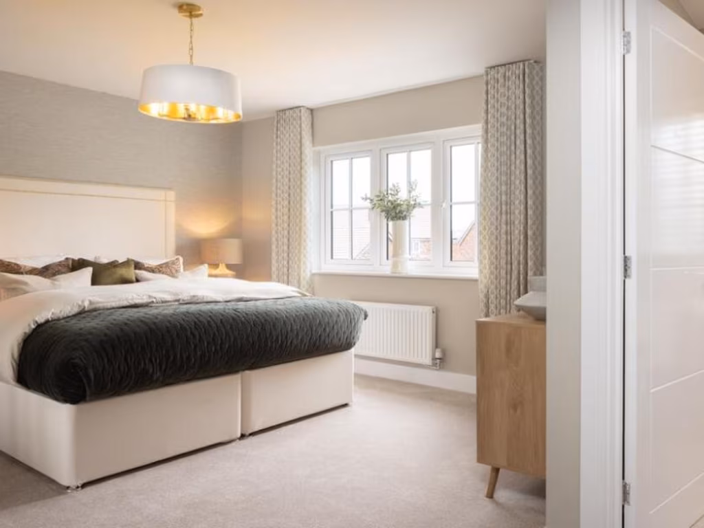
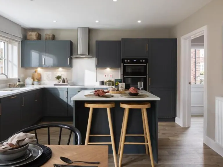
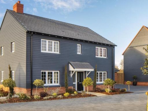
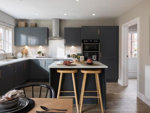
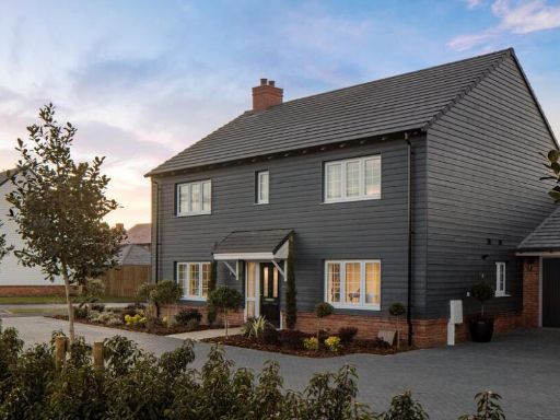
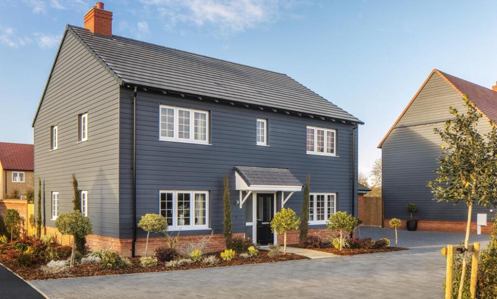
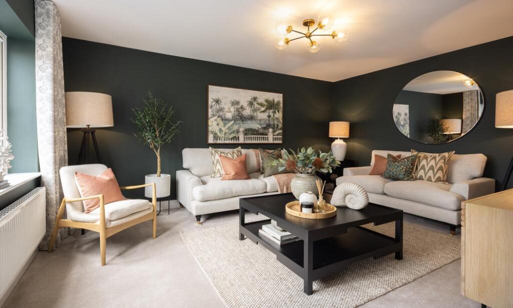
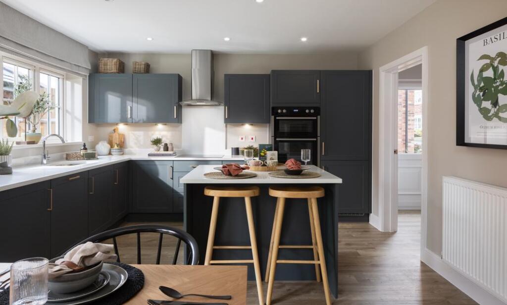
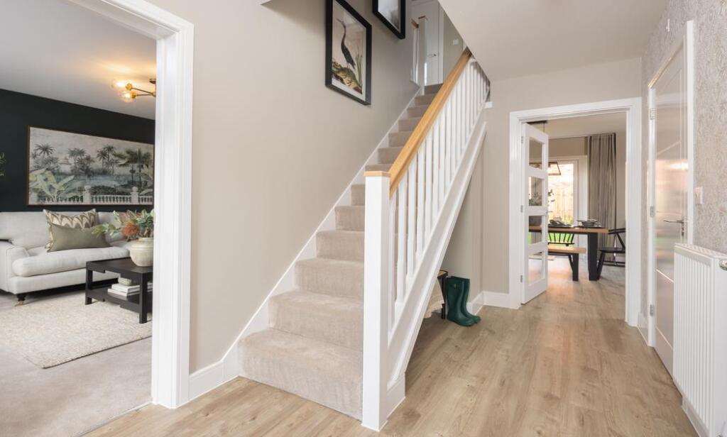
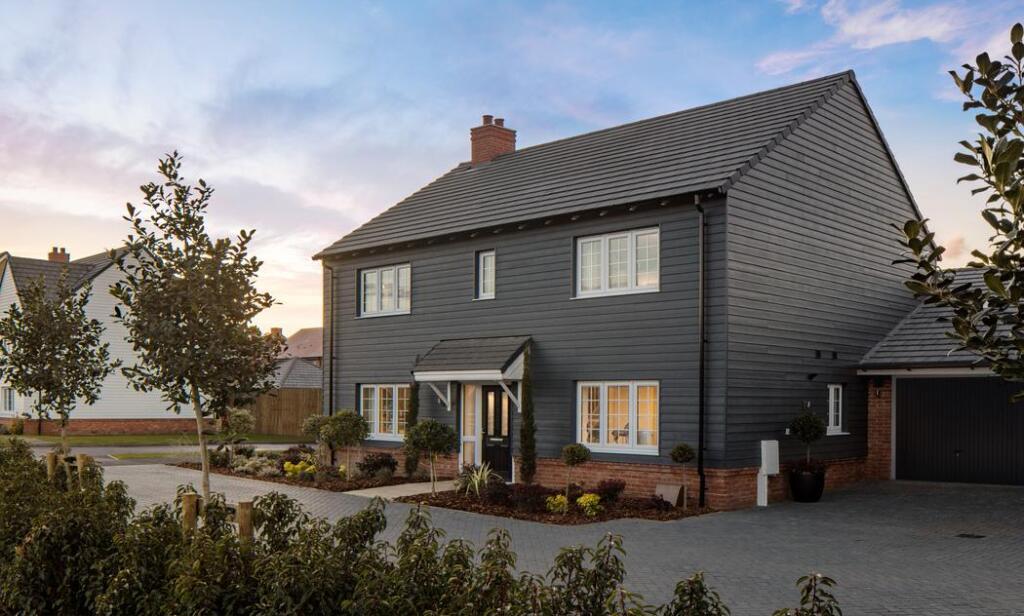
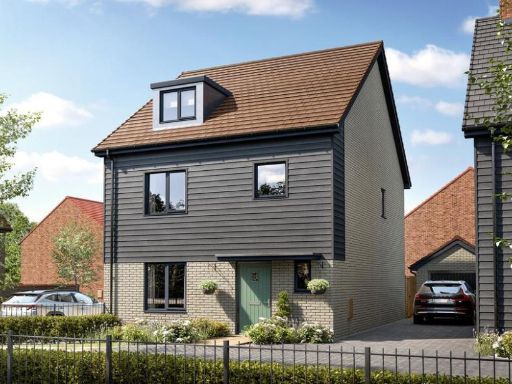
- modern detached house contemporary
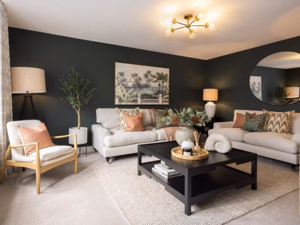
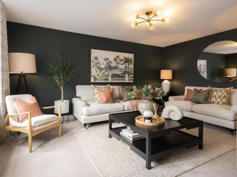
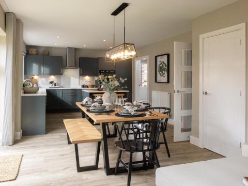
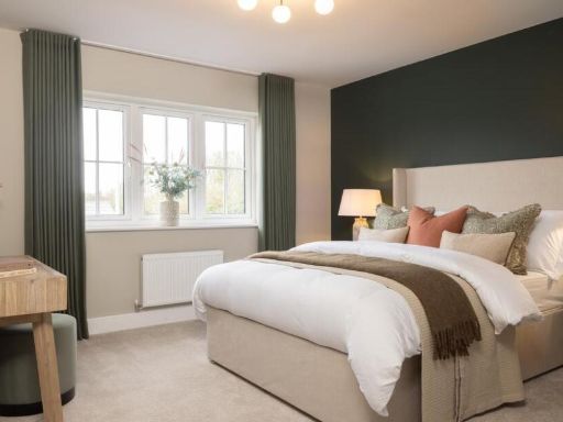
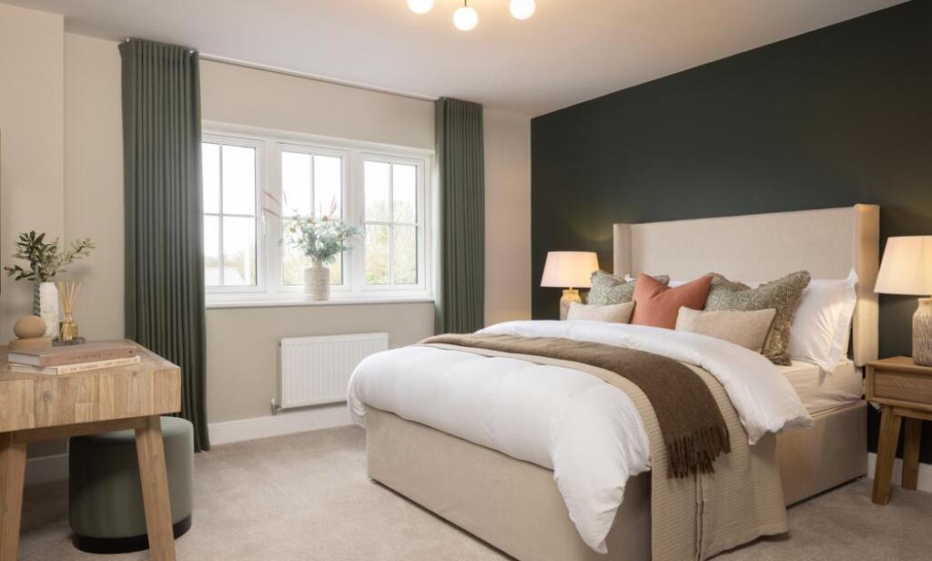
- living room contemporary
Floorplan Description
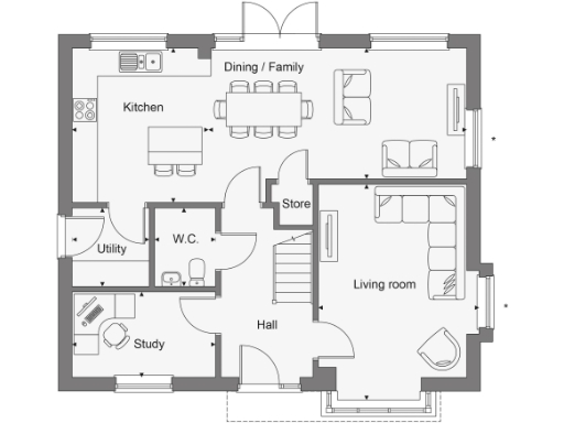
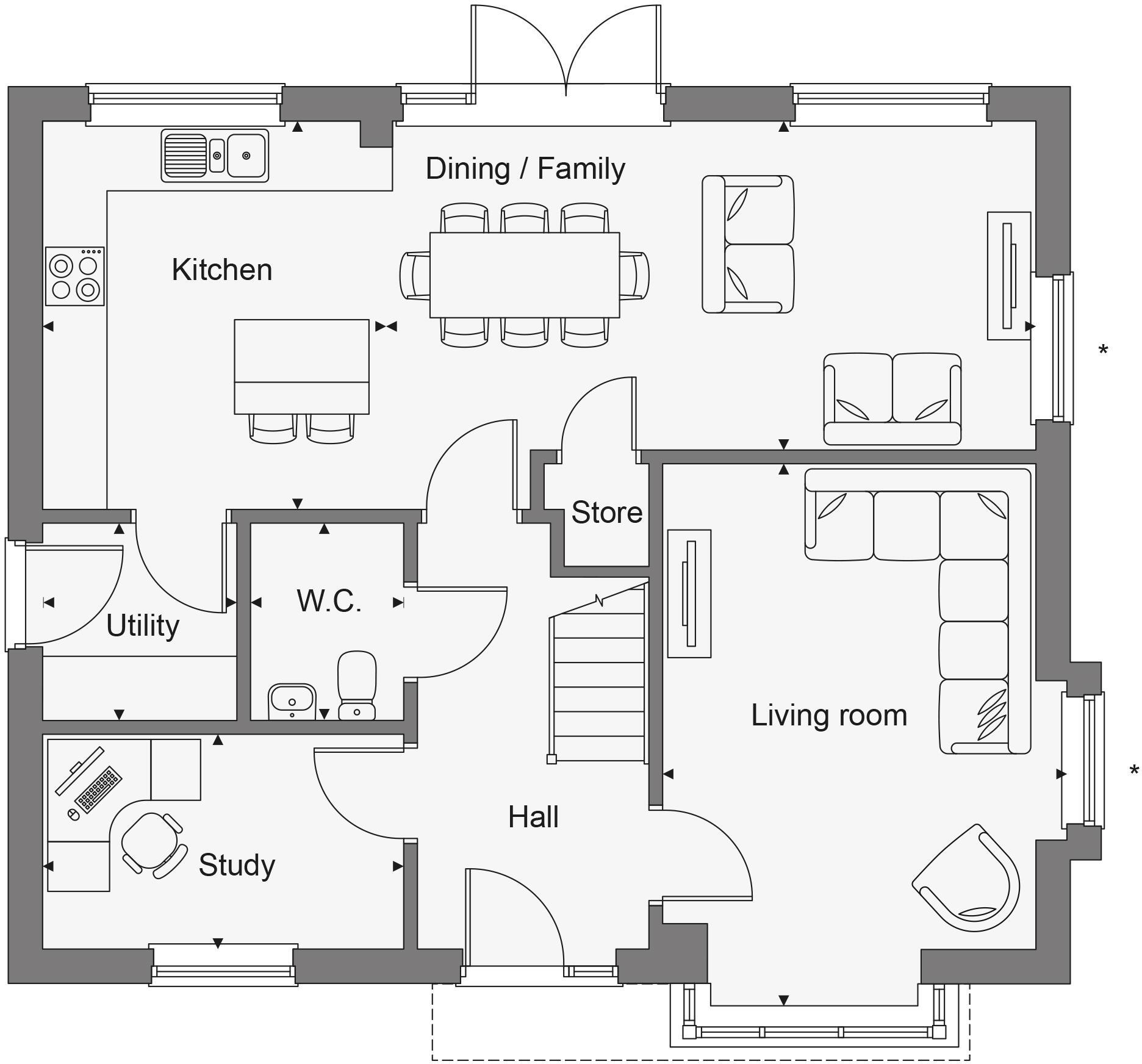
- A floorplan with common family living spaces including dining, kitchen, and living room.
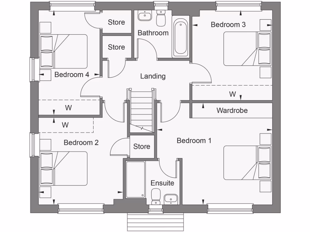
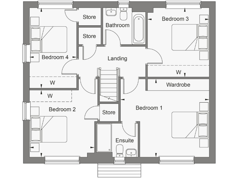
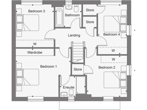
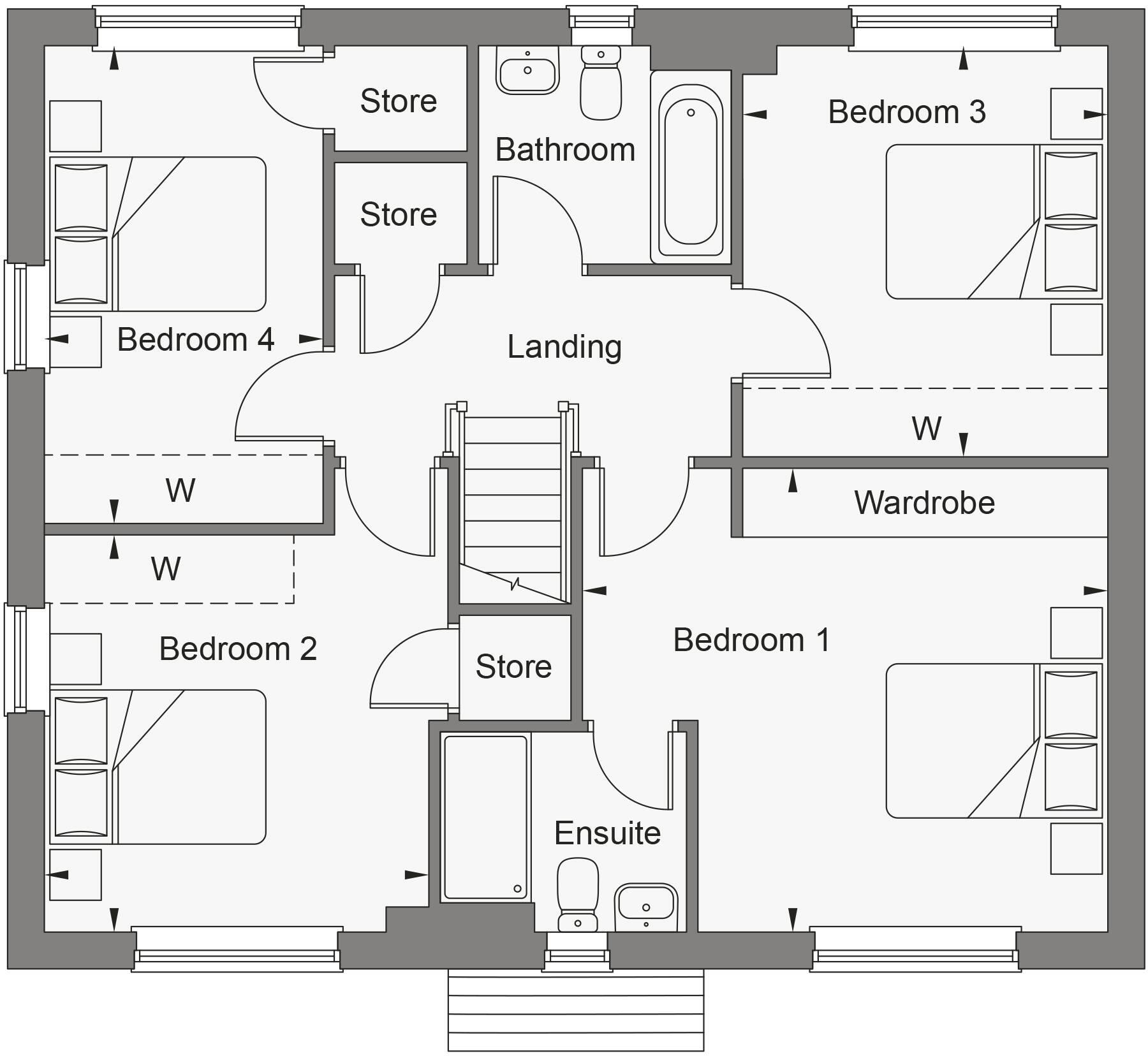
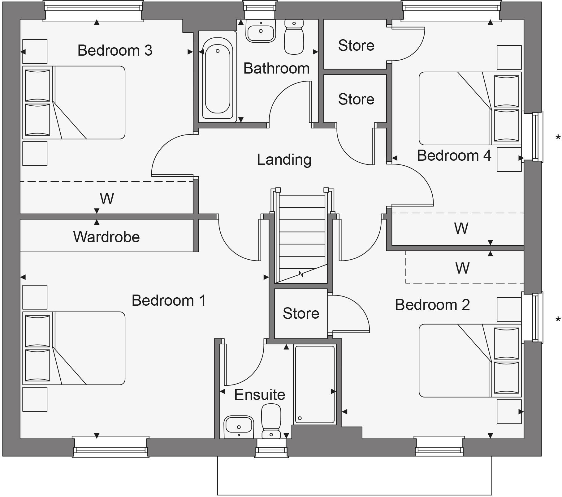
- A multi-bedroom upper floor layout with several storage areas and bathrooms.
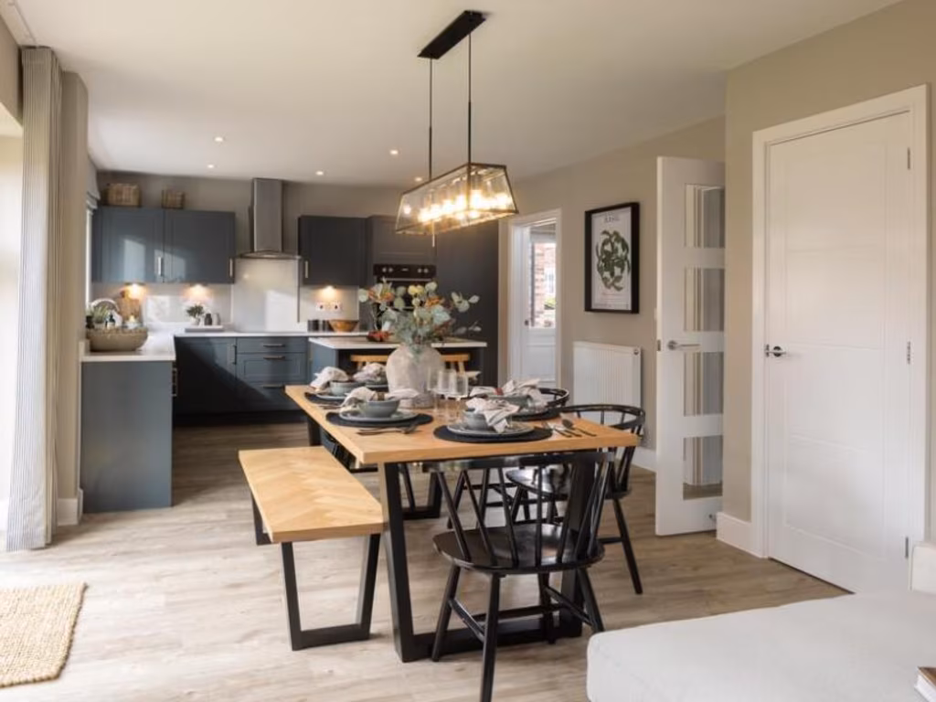
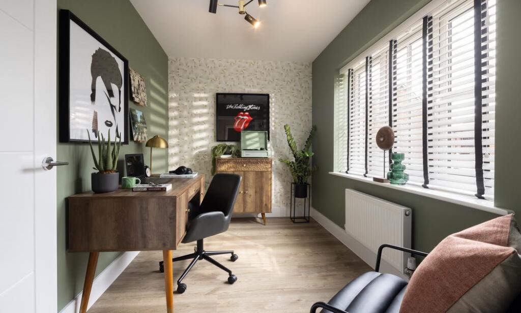
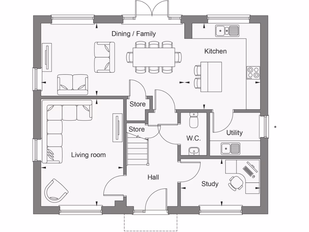
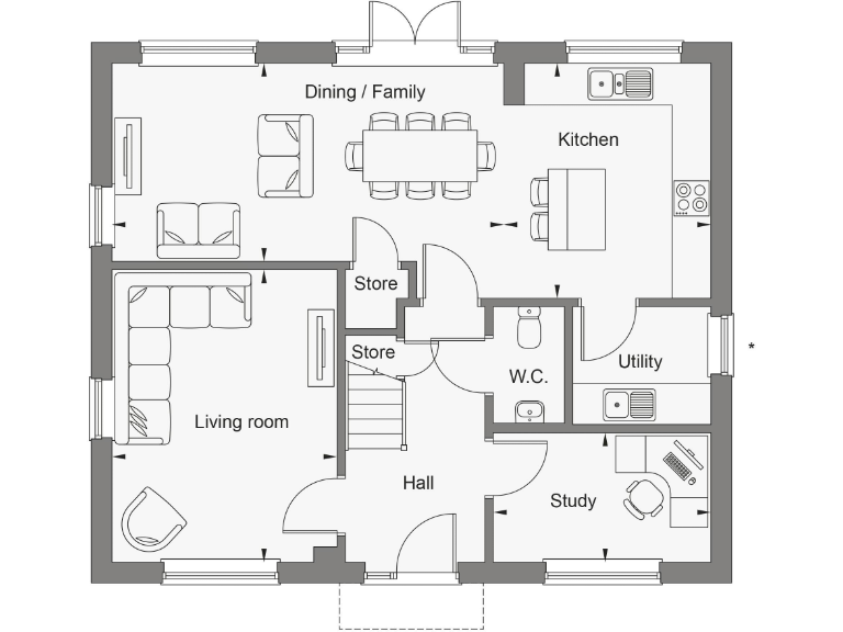
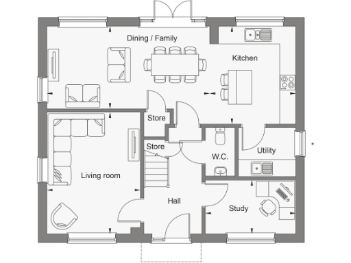
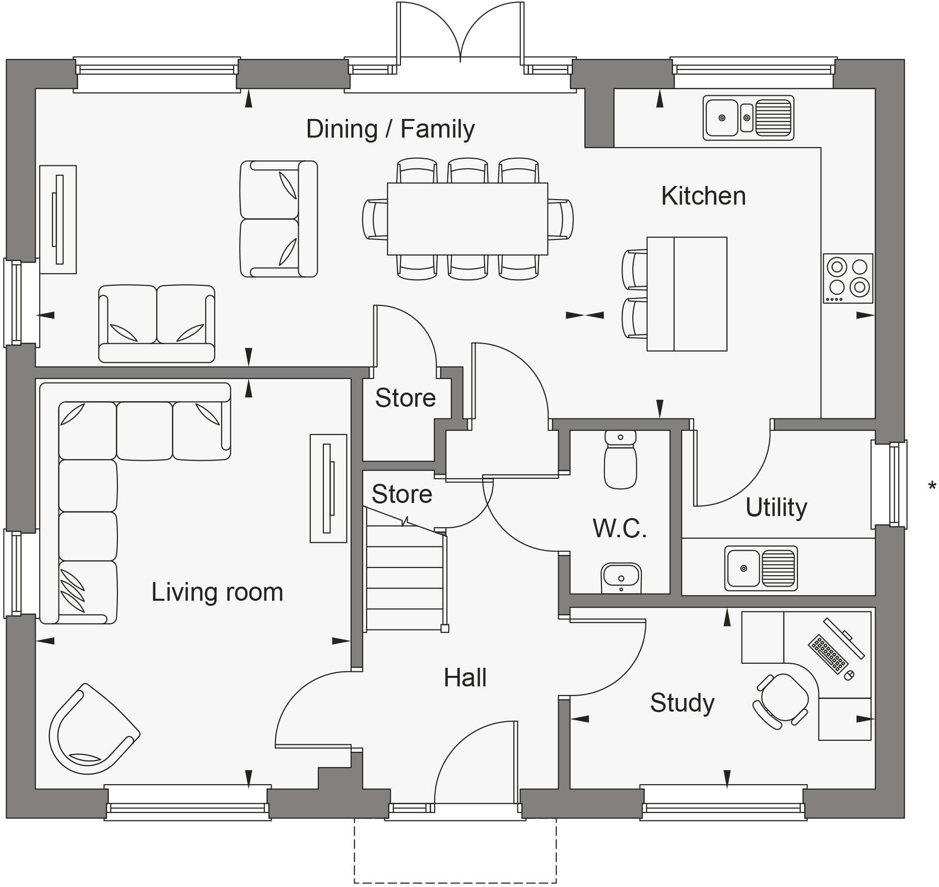
- Ground floor plan showing Dining / Family, Kitchen, Utility, W.C., Store, Living room, Study and Hall.
Rooms
- Dining / Family:
- Kitchen:
- Living room:
- W.C.:
- Utility:
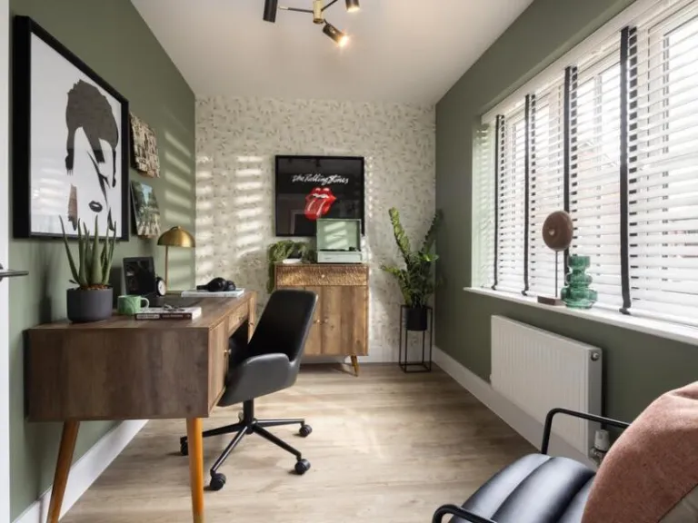
- Study:
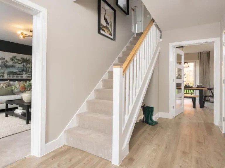
- Hall:
- Store:
- Bedroom 4:
- Bedroom 2:
- Bedroom 3:
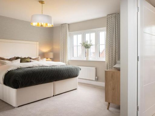
- Bedroom 1:
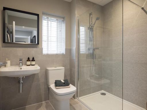
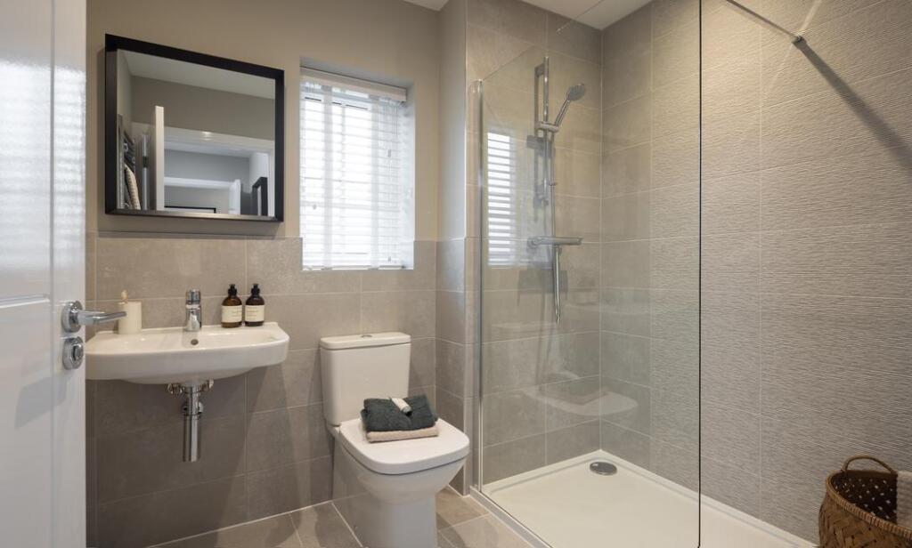
- Bathroom:
- Landing:
- Ensuite:
- Dining / Family:
- Kitchen:
- Utility:
- W.C.:
- Store:
- Living room:
- Study:
- Hall:
- Bedroom 3:
- Bathroom:
- Store:
- Store:
- Bedroom 4:
- Wardrobe:
- Bedroom 1:
- Landing:
- Store:
- Ensuite:
- Bedroom 2:
Textual Property Features
- Is New Build
- Has Garden
- Success
Detected Visual Features
- modern
- detached
- house
- contemporary
- new build
- double-story
- family home
- residential
- suburban
- siding
- garage
- living room
- dark walls
- modern lighting
- plush couches
- decorative plants
Nearby Schools
- Beckers Green Primary School
- Gosfield Community Primary School
- St Margaret's Preparatory School
- Richard de Clare Community Academy
- White Notley Church of England Voluntary Controlled Primary School
- St Michael's Church of England Voluntary Aided Primary School
- Rayne Primary and Nursery School
- Great Bradfords Junior School
- Great Bradfords Infant and Nursery School
- Tabor Academy
- Stisted Church of England Primary Academy
- Felsted Primary School
- Cressing Primary School
- Notley Green Primary School
- John Ray Junior School
- Lyons Hall School
- Bocking Primary School
- Wethersfield CofE VC Primary School
- Great Leighs Primary School
- Silver End Academy
- White Court School
- Notley High School and Braintree Sixth Form
- Alec Hunter Academy
- St Francis Catholic Primary School, Braintree
- John Bunyan Primary School and Nursery
- Shalford Primary School
- Holy Trinity Church of England Voluntary Controlled Primary School, Halstead
- Gosfield School
Nearest Bars And Restaurants
- Id: 4070141470
- Tags:
- Amenity: pub
- Name: The Bell
- Wikidata: Q26416470
- TagsNormalized:
- Lat: 51.8982245
- Lon: 0.5206308
- FullGeoHash: u10r5zg15d4r
- PartitionGeoHash: u10r
- Images:
- FoodStandards: null
- Distance: 1623.1
,- Id: 6214772836
- Tags:
- Amenity: pub
- Floor:
- Name: The Angel
- Real_ale: Courage and Butcombe (may vary)
- Wikidata: Q26415663
- TagsNormalized:
- Lat: 51.8859075
- Lon: 0.5568545
- FullGeoHash: u10rhtt3rdhy
- PartitionGeoHash: u10r
- Images:
- FoodStandards: null
- Distance: 1612.4
,- Id: 852836968
- Tags:
- Amenity: pub
- Name: Bocking Village Club
- TagsNormalized:
- Lat: 51.9042779
- Lon: 0.5569497
- FullGeoHash: u10rk8vs3fev
- PartitionGeoHash: u10r
- Images:
- FoodStandards: null
- Distance: 1103.5
,- Id: 210631528
- Tags:
- Amenity: pub
- Building: yes
- Name: The Rose and Crown
- Wikidata: Q26415642
- TagsNormalized:
- Lat: 51.9025824
- Lon: 0.5550731
- FullGeoHash: u10rk8s4qnse
- PartitionGeoHash: u10r
- Images:
- FoodStandards: null
- Distance: 888.6
,- Id: 2207147619
- Tags:
- Amenity: pub
- Name: The Retreat
- TagsNormalized:
- Lat: 51.9014897
- Lon: 0.5537743
- FullGeoHash: u10rk87hpfuj
- PartitionGeoHash: u10r
- Images:
- FoodStandards: null
- Distance: 748.9
}
Nearest General Shops
- Id: 6224020581
- Tags:
- Name: Blue Screen Solutions
- Shop: computer
- TagsNormalized:
- Lat: 51.8797985
- Lon: 0.5521032
- FullGeoHash: u10rhs6j8zmu
- PartitionGeoHash: u10r
- Images:
- FoodStandards: null
- Distance: 2110.9
,- Id: 5237864143
- Tags:
- Addr:
- Housenumber: 36
- Postcode: CM7 2YW
- Street: Warner Drive
- Name: Searing Motorcycles
- Shop: motorcycle
- Website: http://searings.com/
- TagsNormalized:
- Lat: 51.8836882
- Lon: 0.5346038
- FullGeoHash: u10rhjjk3hmr
- PartitionGeoHash: u10r
- Images:
- FoodStandards: null
- Distance: 1740.9
,- Id: 5705576666
- Tags:
- Addr:
- City: Braintree
- Country: GB
- Postcode: CM7 2YN
- Street: Springwood Drive
- Unit: 29
- Description: Fancy Dress Hire
- Name: Chameleon Costumes Fancy Dress
- Shop: clothes
- Website: http://chameleoncostumes.co.uk/contact-us.html
- TagsNormalized:
- Lat: 51.8877399
- Lon: 0.5386243
- FullGeoHash: u10rhmb5yzg2
- PartitionGeoHash: u10r
- Images:
- FoodStandards: null
- Distance: 1222
}
Nearest Grocery shops
- Id: 353334275
- Tags:
- Brand: Co-op Food
- Brand:wikidata: Q3277439
- Brand:wikipedia: en:Co-op Food
- Name: Co-op Food
- Operator: The Co-operative Group
- Operator:wikidata: Q117202
- Shop: convenience
- TagsNormalized:
- co-op
- co-op food
- food
- convenience
- shop
- Lat: 51.8829724
- Lon: 0.5449632
- FullGeoHash: u10rhmhb4x41
- PartitionGeoHash: u10r
- Images:
- FoodStandards: null
- Distance: 1689.3
,- Id: 346286449
- Tags:
- Brand: One Stop
- Brand:wikidata: Q65954217
- Name: One Stop
- Shop: convenience
- TagsNormalized:
- Lat: 51.8888642
- Lon: 0.5509805
- FullGeoHash: u10rhw14wc2g
- PartitionGeoHash: u10r
- Images:
- FoodStandards: null
- Distance: 1131.1
,- Id: 457095502
- Tags:
- Addr:
- City: Bocking Churchstreet
- Housenumber: 62
- Postcode: CM7 5JY
- Street: Church Street
- Building: yes
- Name: The Co-operative Food
- Opening_hours: Mo-Su 07:00-22:00
- Shop: supermarket
- TagsNormalized:
- the co-operative food
- food
- shop
- Lat: 51.901955
- Lon: 0.5544454
- FullGeoHash: u10rk87wz98m
- PartitionGeoHash: u10r
- Images:
- FoodStandards: null
- Distance: 814.8
}
Nearest Religious buildings
- Id: 147586656
- Tags:
- Amenity: place_of_worship
- Denomination: anglican
- Name: St Mary and St Christopher, Panfield
- Religion: christian
- Wikidata: Q17557312
- TagsNormalized:
- place of worship
- anglican
- christian
- church
- Lat: 51.8995494
- Lon: 0.5256715
- FullGeoHash: u10r7bnbc11p
- PartitionGeoHash: u10r
- Images:
- FoodStandards: null
- Distance: 1286.5
,- Id: 210584412
- Tags:
- Amenity: school
- Building: yes
- Name: Bocking Church Street Community Primary School
- TagsNormalized:
- Lat: 51.9037427
- Lon: 0.5558468
- FullGeoHash: u10rk8uc0nvm
- PartitionGeoHash: u10r
- Images:
- FoodStandards: null
- Distance: 1007.2
,- Id: 145349386
- Tags:
- Amenity: place_of_worship
- Denomination: anglican
- Name: Saint Mary the Virgin, Bocking
- Religion: christian
- Wikidata: Q17535793
- TagsNormalized:
- place of worship
- anglican
- christian
- church
- Lat: 51.901986
- Lon: 0.5522951
- FullGeoHash: u10rk86nvrmn
- PartitionGeoHash: u10r
- Images:
- FoodStandards: null
- Distance: 695
}
Nearest Medical buildings
- Id: 1693859187
- Tags:
- Amenity: pharmacy
- Brand: Boots
- Brand:wikidata: Q6123139
- Dispensing: yes
- Drive_through: no
- Healthcare: pharmacy
- Name: Boots
- TagsNormalized:
- pharmacy
- boots
- health
- healthcare
- Lat: 51.8465365
- Lon: 0.6224046
- FullGeoHash: u10qynm5znft
- PartitionGeoHash: u10q
- Images:
- FoodStandards: null
- Distance: 7855.7
,- Id: 130073956
- Tags:
- Addr:
- City: Braintree
- Country: GB
- Housename: St Michael's House
- Postcode: CM7 1EY
- Street: St Michael's Lane
- Amenity: dentist
- Building: yes
- Healthcare: dentist
- Name: Dr R Patel
- TagsNormalized:
- Lat: 51.8777261
- Lon: 0.5504731
- FullGeoHash: u10rhs0cdvn6
- PartitionGeoHash: u10r
- Images:
- FoodStandards: null
- Distance: 2311.4
,- Id: 546893183
- Tags:
- Addr:
- City: Braintree
- Postcode: CM7 2AE
- Street: Mace Avenue
- Amenity: doctors
- Building: yes
- Healthcare: doctor
- Name: Blandford Medical Centre
- Opening_hours: Mo-Fr 08:00-18:30; Sa-Su off
- Operator: NHS England
- Phone: +44 1376 347100
- Website: http://www.blandfordmedicalcentre.co.uk/
- TagsNormalized:
- doctor
- doctors
- health
- healthcare
- Lat: 51.8789889
- Lon: 0.5408255
- FullGeoHash: u10rhk3c40kx
- PartitionGeoHash: u10r
- Images:
- FoodStandards: null
- Distance: 2144.8
,- Id: 715548760
- Tags:
- Addr:
- City: Braintree
- Street: Chadwick Drive
- Amenity: hospital
- Emergency: no
- Healthcare: hospital
- Healthcare:speciality: maternity
- Name: Braintree Community Hospital
- Operator: NHS
- Operator:type: government
- Operator:wikidata: Q918396
- TagsNormalized:
- hospital
- health
- healthcare
- maternity
- Lat: 51.8795775
- Lon: 0.5408639
- FullGeoHash: u10rhk3u7n1q
- PartitionGeoHash: u10r
- Images:
- FoodStandards: null
- Distance: 2079.5
}
Nearest Airports
- Id: 495488524
- Tags:
- Aerodrome: international
- Aerodrome:type: public
- Aeroway: aerodrome
- Alt_name: Stansted
- Iata: STN
- Icao: EGSS
- Is_in: Essex,England,UK
- Name: London Stansted Airport
- Ref: STN
- Source: Gagravarr_Airports
- Website: https://www.stanstedairport.com/
- Wikidata: Q8709
- Wikipedia: en:London Stansted Airport
- TagsNormalized:
- airport
- international airport
- Lat: 51.8869677
- Lon: 0.2429264
- FullGeoHash: u10pjt8zkxg4
- PartitionGeoHash: u10p
- Images:
- FoodStandards: null
- Distance: 20717.5
}
Nearest Leisure Facilities
- Id: 362534414
- Tags:
- Description: Disused golf course
- Disused:
- Leisure: golf_course
- Name: Towerland Golf Course (closed)
- Note: Closed, see e.g. http://www.essexchronicle.co.uk/Towerlands-Golf-Club-s-closure-bitter-blow/story-15431331-detail/story.html and https://en.leadingcourses.com/europe+united-kingdom+england+essex/towerlands-golf-club/
- TagsNormalized:
- Lat: 51.8963935
- Lon: 0.540225
- FullGeoHash: u10rhr3qkhuv
- PartitionGeoHash: u10r
- Images:
- FoodStandards: null
- Distance: 340.9
,- Id: 31723470
- Tags:
- TagsNormalized:
- Lat: 51.8961044
- Lon: 0.5465277
- FullGeoHash: u10rhrmuxp09
- PartitionGeoHash: u10r
- Images:
- FoodStandards: null
- Distance: 275.4
,- Id: 31723561
- Tags:
- Landuse: quarry
- Leisure: sports_centre
- Name: Braintree BMX Track
- TagsNormalized:
- sports
- sports centre
- leisure
- bmx
- track
- Lat: 51.8965812
- Lon: 0.545854
- FullGeoHash: u10rhrmrrrfj
- PartitionGeoHash: u10r
- Images:
- FoodStandards: null
- Distance: 205.8
,- Id: 512532543
- Tags:
- TagsNormalized:
- Lat: 51.8989033
- Lon: 0.5416242
- FullGeoHash: u10rhrfmhbb3
- PartitionGeoHash: u10r
- Images:
- FoodStandards: null
- Distance: 200.5
,- Id: 405297676
- Tags:
- Building: yes
- Leisure: sports_centre
- Name: Towerlands Leisure Centre
- TagsNormalized:
- sports
- sports centre
- leisure
- Lat: 51.8979587
- Lon: 0.543199
- FullGeoHash: u10rhrex92ww
- PartitionGeoHash: u10r
- Images:
- FoodStandards: null
- Distance: 77.9
}
Nearest Tourist attractions
- Id: 4195908298
- Tags:
- Name: John Ray Garden
- Tourism: attraction
- TagsNormalized:
- Lat: 51.8837687
- Lon: 0.5539758
- FullGeoHash: u10rht5kue6r
- PartitionGeoHash: u10r
- Images:
- FoodStandards: null
- Distance: 1732.8
,- Id: 4195908299
- Tags:
- Name: Wildlife Area
- Tourism: attraction
- TagsNormalized:
- Lat: 51.884406
- Lon: 0.5538161
- FullGeoHash: u10rht728f71
- PartitionGeoHash: u10r
- Images:
- FoodStandards: null
- Distance: 1663.3
,- Id: 145348981
- Tags:
- Man_made: windmill
- Name: Bocking Windmill
- Tourism: attraction
- Wikidata: Q4936285
- TagsNormalized:
- Lat: 51.9043432
- Lon: 0.5614006
- FullGeoHash: u10rkbbu9wfe
- PartitionGeoHash: u10r
- Images:
- FoodStandards: null
- Distance: 1360.7
}
Nearest Train stations
- Id: 55420748
- Tags:
- Name: Cressing
- Naptan:
- Network: National Rail
- Public_transport: station
- Railway: station
- Ref:
- Train: yes
- Wikidata: Q1886114
- Wikipedia: en:Cressing railway station
- TagsNormalized:
- Lat: 51.852306
- Lon: 0.5779203
- FullGeoHash: u10qvpkvdd2t
- PartitionGeoHash: u10q
- Images:
- FoodStandards: null
- Distance: 5597.1
,- Id: 187038971
- Tags:
- Amenity: shelter
- Building: train_station
- TagsNormalized:
- shelter
- station
- train
- train station
- Lat: 51.8692466
- Lon: 0.5682988
- FullGeoHash: u10rhftb626k
- PartitionGeoHash: u10r
- Images:
- FoodStandards: null
- Distance: 3612.8
,- Id: 55420882
- Tags:
- Addr:
- Postcode: CM77 8YH
- Street: Chapel Hill Retail Park
- Name: Braintree Freeport
- Naptan:
- Network: National Rail
- Note: FIXME location approximate, judged from landsat
- Public_transport: station
- Railway: station
- Ref:
- Train: yes
- Wikidata: Q2540597
- Wikipedia: en:Braintree Freeport railway station
- TagsNormalized:
- Lat: 51.8692939
- Lon: 0.5681965
- FullGeoHash: u10rhft8xcnn
- PartitionGeoHash: u10r
- Images:
- FoodStandards: null
- Distance: 3604.9
,- Id: 1997260503
- Tags:
- Name: Braintree
- Name:lt: Breintris
- Naptan:
- Network: National Rail
- Old_name: Braintree and Bocking
- Public_transport: station
- Railway: station
- Ref:
- Train: yes
- Wikidata: Q2716690
- Wikipedia: en:Braintree railway station (England)
- TagsNormalized:
- Lat: 51.8753105
- Lon: 0.5567303
- FullGeoHash: u10rhet7sfb0
- PartitionGeoHash: u10r
- Images:
- FoodStandards: null
- Distance: 2680.4
,- Id: 187033767
- Tags:
- Amenity: cafe
- Building: train_station
- Name: Cafe Alexander
- TagsNormalized:
- cafe
- station
- train
- train station
- Lat: 51.8753588
- Lon: 0.5565999
- FullGeoHash: u10rhet7ceyb
- PartitionGeoHash: u10r
- Images:
- FoodStandards: null
- Distance: 2672.4
}
Nearest Hotels
- Id: 104310066
- Tags:
- Brand: Premier Inn
- Brand:wikidata: Q2108626
- Brand:wikipedia: en:Premier Inn
- Building: yes
- Internet_access: wlan
- Internet_access:fee: customers
- Internet_access:operator: Virgin Media
- Internet_access:ssid: Premier Inn Free Wi-Fi
- Name: Premier Inn
- Tourism: hotel
- Wheelchair: yes
- TagsNormalized:
- Lat: 51.8691903
- Lon: 0.5819277
- FullGeoHash: u10rj4rxzvus
- PartitionGeoHash: u10r
- Images:
- FoodStandards: null
- Distance: 4129.3
,- Id: 146338280
- Tags:
- Addr:
- Brand: Holiday Inn Express
- Brand:wikidata: Q5880423
- Brand:wikipedia: en:Holiday Inn Express
- Building: hotel
- Key: FLP BP Alt Tues
- Name: Holiday Inn Express
- Source:
- Tourism: hotel
- TagsNormalized:
- Lat: 51.8684265
- Lon: 0.5365901
- FullGeoHash: u10rh4qerrqx
- PartitionGeoHash: u10r
- Images:
- FoodStandards: null
- Distance: 3348.1
,- Id: 10661255737
- Tags:
- Brand: Travelodge
- Brand:wikidata: Q9361374
- Internet_access: wlan
- Internet_access:fee: customers
- Internet_access:ssid: Travelodge WiFi
- Name: Travelodge
- Tourism: hotel
- TagsNormalized:
- Lat: 51.8774746
- Lon: 0.5545117
- FullGeoHash: u10rhs5b1n1y
- PartitionGeoHash: u10r
- Images:
- FoodStandards: null
- Distance: 2404.7
}
Tags
- modern
- detached
- house
- contemporary
- new build
- double-story
- family home
- residential
- suburban
- siding
- garage
- contemporary
- living room
- dark walls
- modern lighting
- plush couches
- decorative plants
Local Market Stats
- Average Price/sqft: £343
- Avg Income: £45800
- Rental Yield: 4.2%
- Social Housing: 9%
- Planning Success Rate: 73%
Similar Properties
 4 bedroom detached house for sale in Panfield Road,
Bocking,
Braintree,
CM7 5BJ, CM7 — £525,000 • 4 bed • 1 bath
4 bedroom detached house for sale in Panfield Road,
Bocking,
Braintree,
CM7 5BJ, CM7 — £525,000 • 4 bed • 1 bath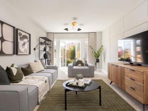 4 bedroom detached house for sale in Panfield Road,
Bocking,
Braintree,
CM7 5BJ, CM7 — £490,000 • 4 bed • 1 bath
4 bedroom detached house for sale in Panfield Road,
Bocking,
Braintree,
CM7 5BJ, CM7 — £490,000 • 4 bed • 1 bath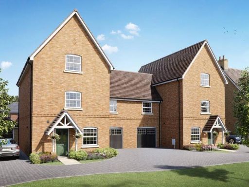 4 bedroom link detached house for sale in Panfield Road,
Bocking,
Braintree,
CM7 5BJ, CM7 — £575,000 • 4 bed • 1 bath • 2000 ft²
4 bedroom link detached house for sale in Panfield Road,
Bocking,
Braintree,
CM7 5BJ, CM7 — £575,000 • 4 bed • 1 bath • 2000 ft² 4 bedroom detached house for sale in The Chartwell, Oaklands, Copford, Colchester, Essex, CO6 — £645,000 • 4 bed • 2 bath
 4 bedroom detached house for sale in Parsonage Road,
Takeley,
CM22 6PU, CM22 — £650,000 • 4 bed • 1 bath
4 bedroom detached house for sale in Parsonage Road,
Takeley,
CM22 6PU, CM22 — £650,000 • 4 bed • 1 bath 4 bedroom detached house for sale in Panfield Road,
Bocking,
Braintree,
CM7 5BJ, CM7 — £575,000 • 4 bed • 1 bath
4 bedroom detached house for sale in Panfield Road,
Bocking,
Braintree,
CM7 5BJ, CM7 — £575,000 • 4 bed • 1 bath
Meta
- {
"@context": "https://schema.org",
"@type": "Residence",
"name": "4 bedroom detached house for sale in Panfield Road, Bocking…",
"description": "",
"url": "https://propertypiper.co.uk/property/5dc4f9f9-e125-4bae-a5ef-a5bb86fc131f",
"image": "https://image-a.propertypiper.co.uk/db0780e0-e9fc-48db-b859-fa5b368d7087-1024.jpeg",
"address": {
"@type": "PostalAddress",
"streetAddress": "Panfield Road,\r\nBocking,\r\nBraintree,\r\nCM7 5BJ",
"postalCode": "CM7 5BJ",
"addressLocality": "Braintree",
"addressRegion": "Braintree",
"addressCountry": "England"
},
"geo": {
"@type": "GeoCoordinates",
"latitude": 51.898159333452064,
"longitude": 0.5442864561787902
},
"numberOfRooms": 4,
"numberOfBathroomsTotal": 1,
"offers": {
"@type": "Offer",
"price": 585000,
"priceCurrency": "GBP",
"availability": "https://schema.org/InStock"
},
"additionalProperty": [
{
"@type": "PropertyValue",
"name": "Feature",
"value": "modern"
},
{
"@type": "PropertyValue",
"name": "Feature",
"value": "detached"
},
{
"@type": "PropertyValue",
"name": "Feature",
"value": "house"
},
{
"@type": "PropertyValue",
"name": "Feature",
"value": "contemporary"
},
{
"@type": "PropertyValue",
"name": "Feature",
"value": "new build"
},
{
"@type": "PropertyValue",
"name": "Feature",
"value": "double-story"
},
{
"@type": "PropertyValue",
"name": "Feature",
"value": "family home"
},
{
"@type": "PropertyValue",
"name": "Feature",
"value": "residential"
},
{
"@type": "PropertyValue",
"name": "Feature",
"value": "suburban"
},
{
"@type": "PropertyValue",
"name": "Feature",
"value": "siding"
},
{
"@type": "PropertyValue",
"name": "Feature",
"value": "garage"
},
{
"@type": "PropertyValue",
"name": "Feature",
"value": "contemporary"
},
{
"@type": "PropertyValue",
"name": "Feature",
"value": "living room"
},
{
"@type": "PropertyValue",
"name": "Feature",
"value": "dark walls"
},
{
"@type": "PropertyValue",
"name": "Feature",
"value": "modern lighting"
},
{
"@type": "PropertyValue",
"name": "Feature",
"value": "plush couches"
},
{
"@type": "PropertyValue",
"name": "Feature",
"value": "decorative plants"
}
]
}
High Res Floorplan Images
Compatible Floorplan Images
FloorplanImages Thumbnail