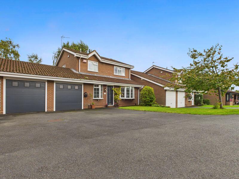
TF10 7LR - 4 bedroom detached house for sale in 36 Fair Oak, Newport,…
View on Property Piper
4 bedroom detached house for sale in 36 Fair Oak, Newport, TF10
Property Details
- Price: £439950
- Bedrooms: 4
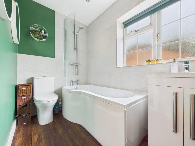
- Bathrooms: 2
- Property Type: undefined
- Property SubType: undefined
Image Descriptions
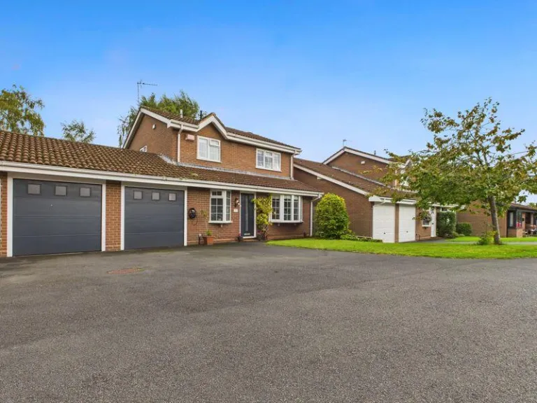
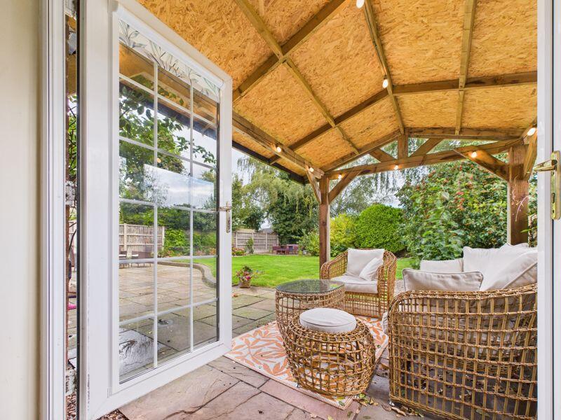
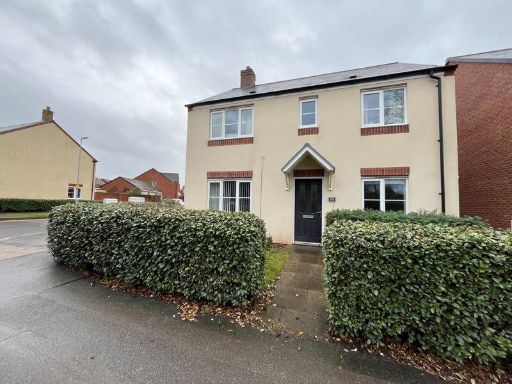
- detached house 1980s suburban
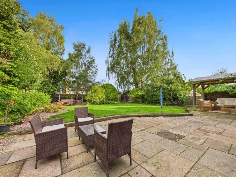
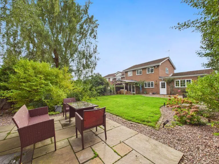
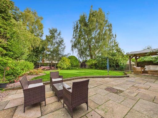
- backyard/garden contemporary
Floorplan Description
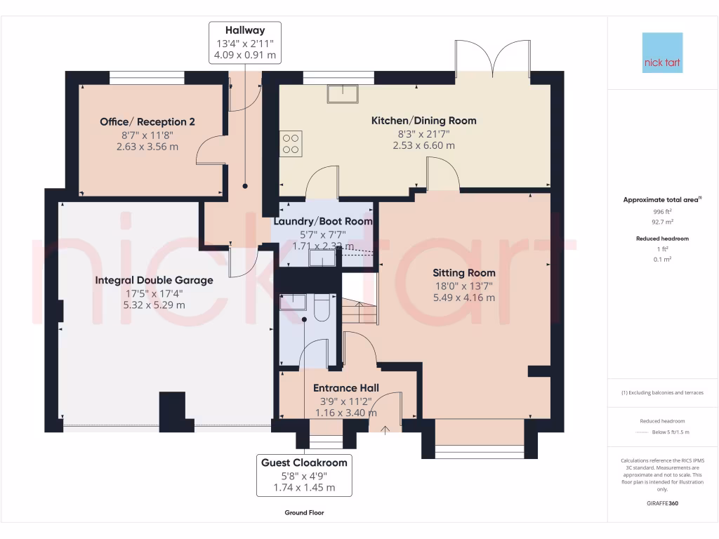
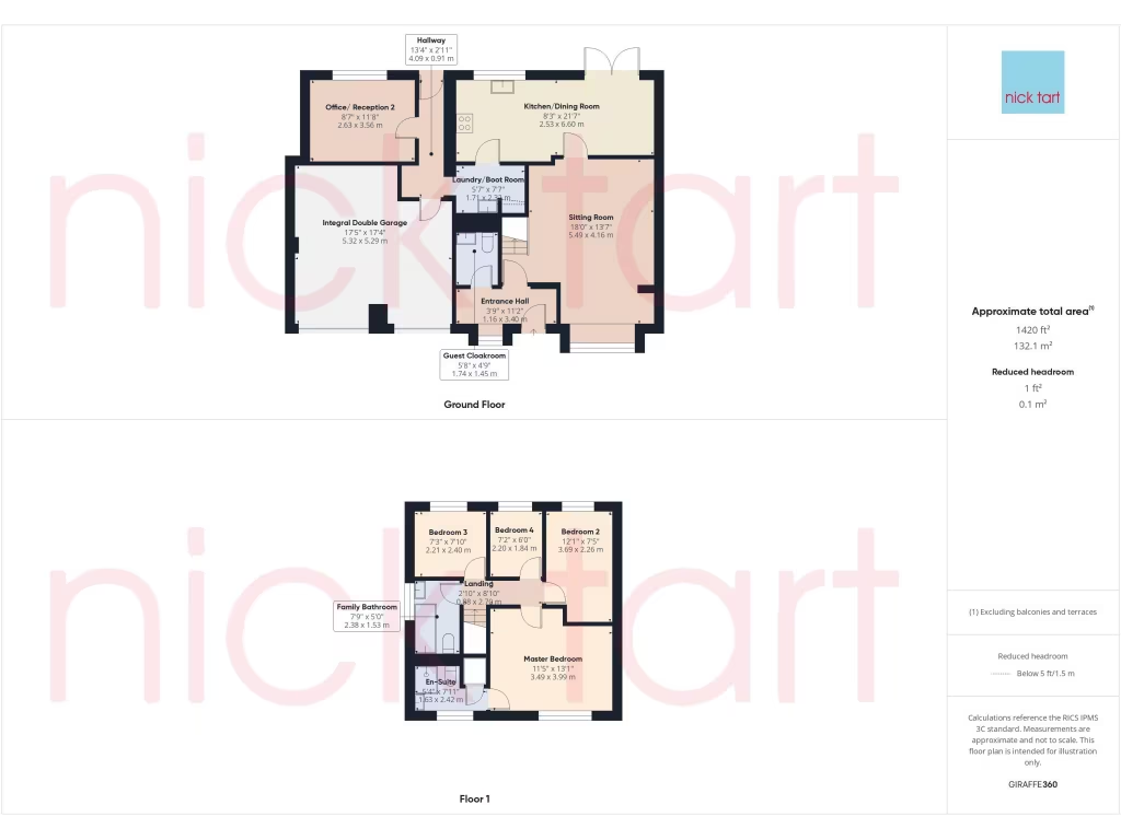
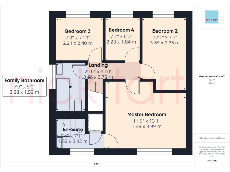
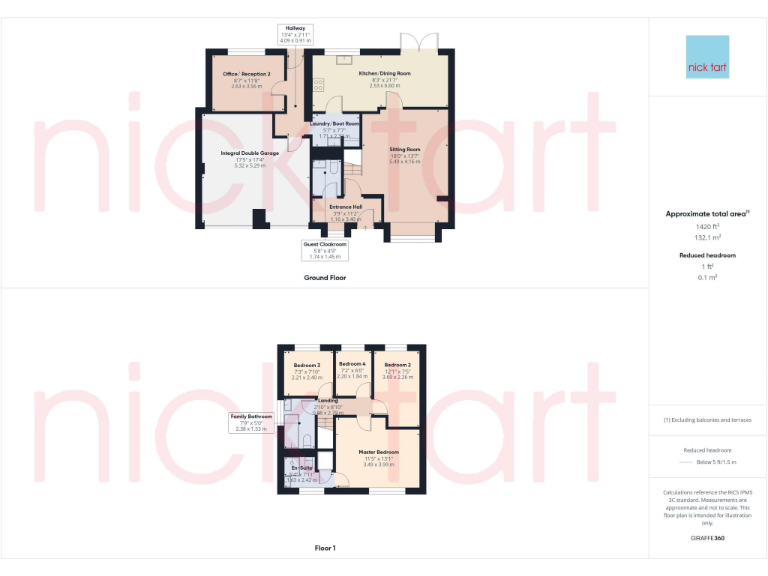
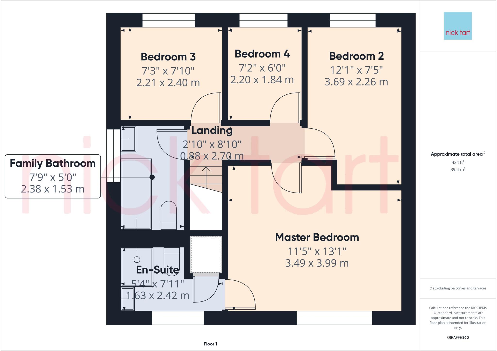
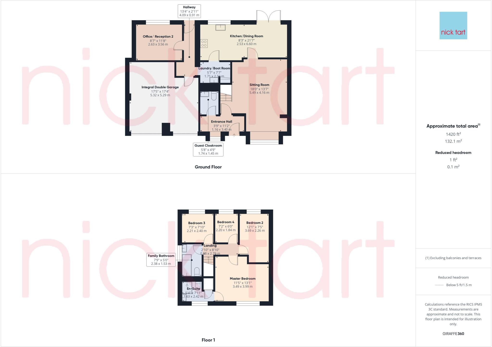
- First floor with four bedrooms, family bathroom and en-suite.
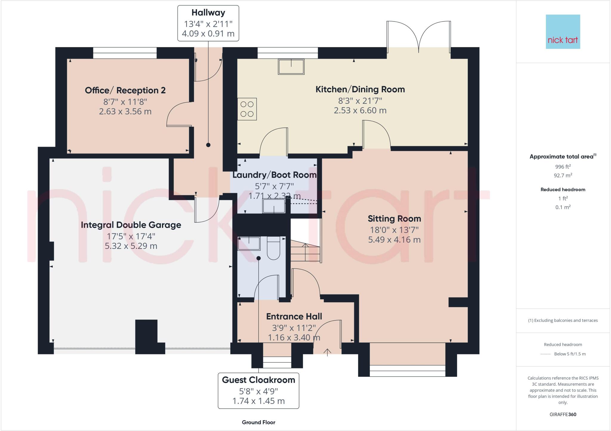
- Two-storey house floorplan with integrated garage (garage excluded from totals).
Rooms
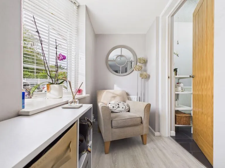
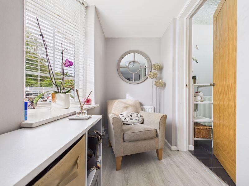
- Hallway:
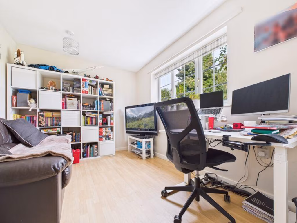
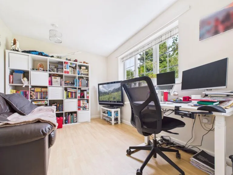
- Office/ Reception 2:
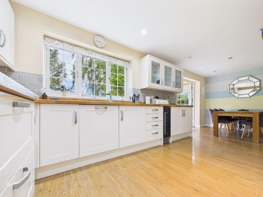
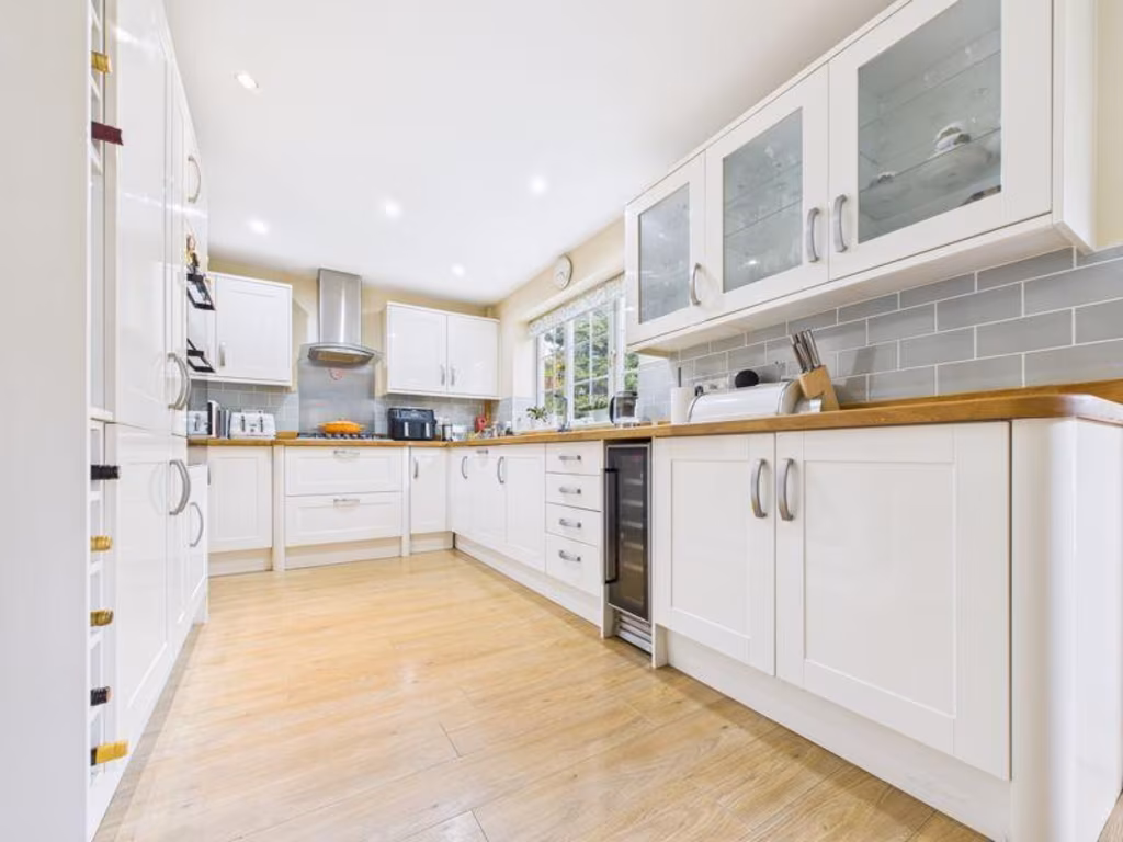
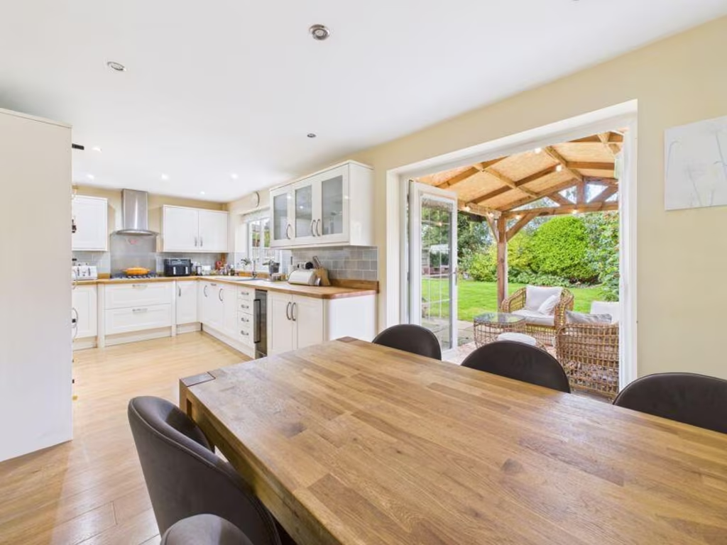
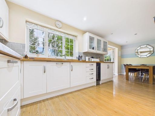
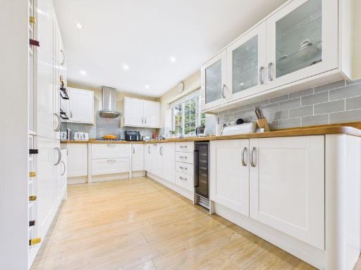
- Kitchen/Dining Room:
- Laundry/Boot Room:
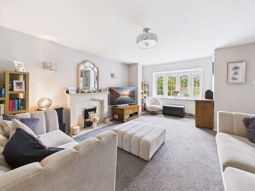
- Sitting Room:
- Integral Double Garage:
- Entrance Hall:
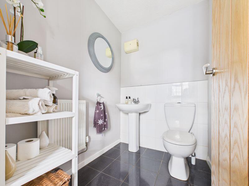
- Guest Cloakroom:
- Hallway:
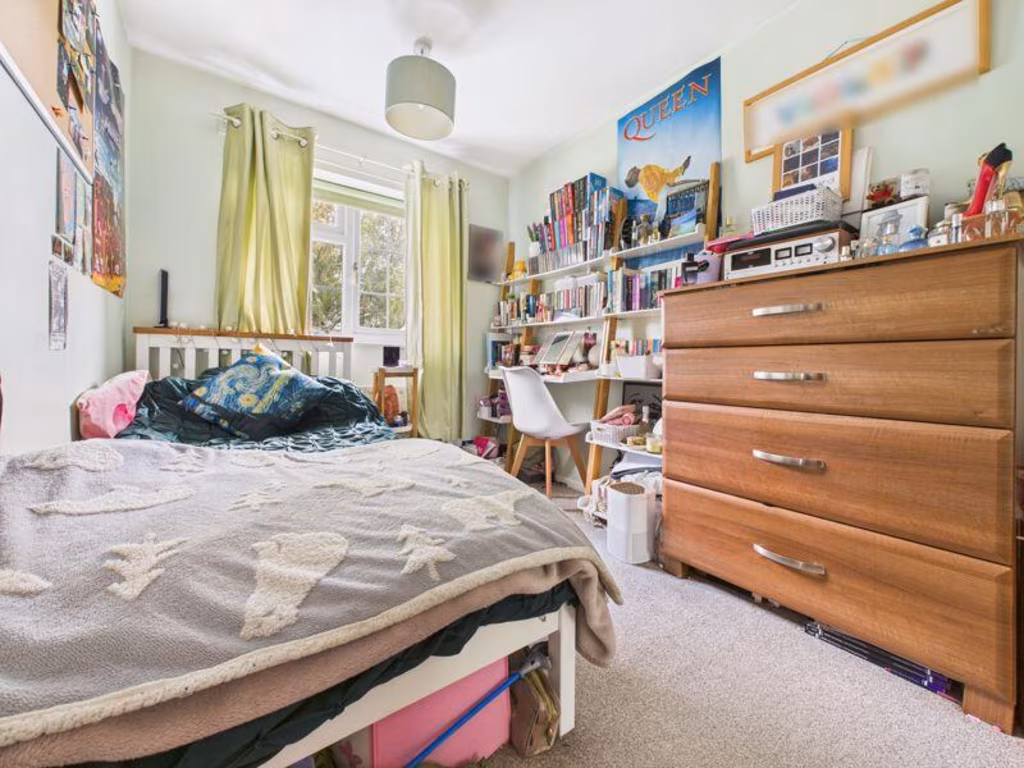
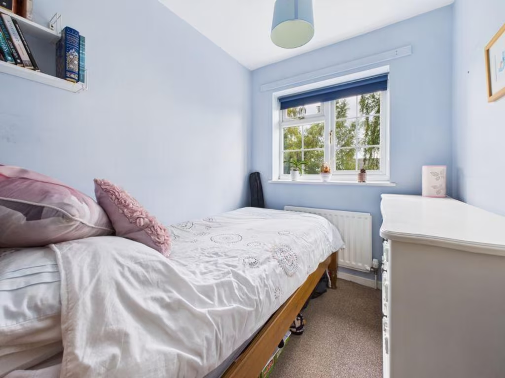
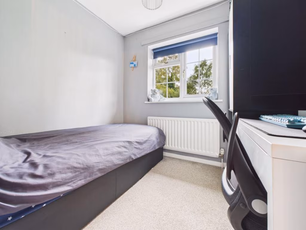
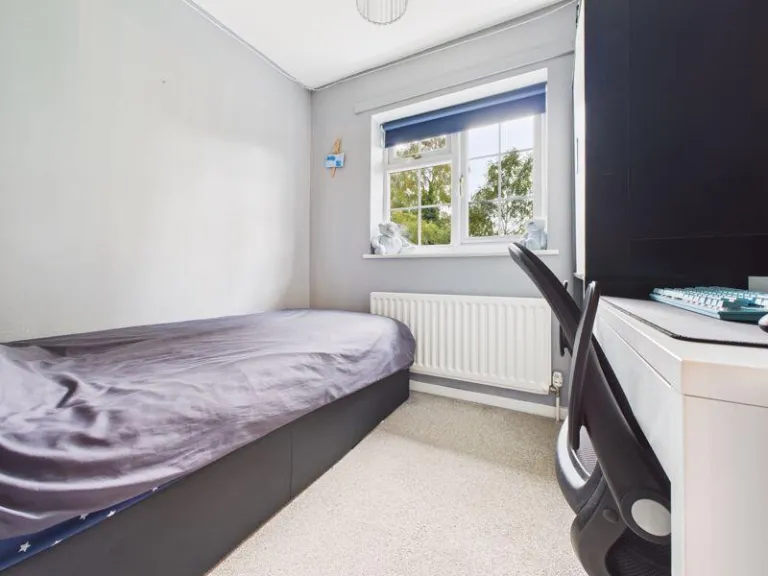
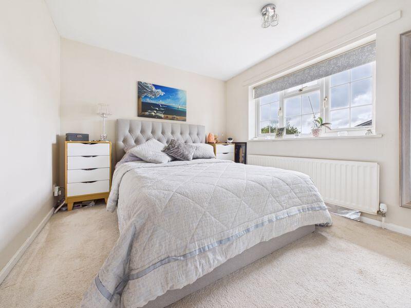
- Bedroom 3:
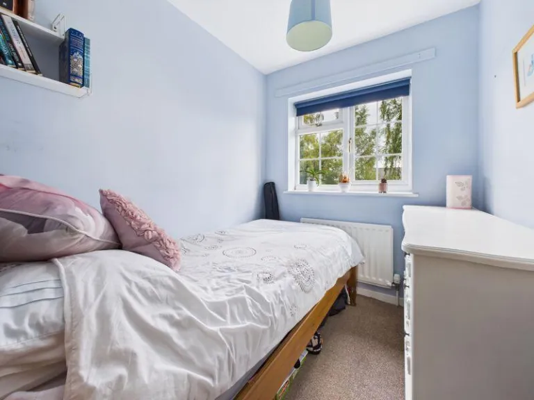
- Bedroom 4:
- Bedroom 2:
- Landing:
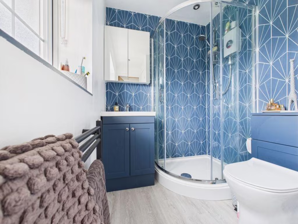
- Family Bathroom:
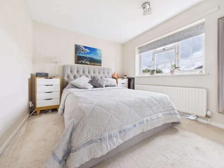
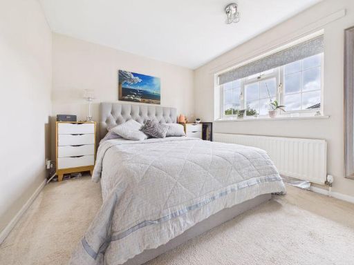
- Master Bedroom:
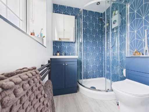
- En-Suite:
- Office/ Reception 2:
- Kitchen/ Dining Room:
- Hallway:
- Sitting Room:
- Laundry/ Boot Room:
- Integral Double Garage:
- Entrance Hall:
- Guest Cloakroom:
- Bedroom 3:
- Bedroom 4:
- Bedroom 2:
- Master Bedroom:
- En-Suite:
- Family Bathroom:
- Landing:
Textual Property Features
Detected Visual Features
- detached
- suburban
- 1980s
- brick
- garage
- garden
- driveway
- family home
- residential area
- large garden
- outdoor space
- patio
- landscaped
- deck area
- lawn
Nearby Schools
- Wrockwardine Wood Infant School and Nursery
- Wrockwardine Wood Church of England Junior School
- Donnington Wood CofE Voluntary Controlled Junior School
- St Lawrence Church of England Voluntary Controlled Primary School
- Sheriffhales Primary School
- Donnington Wood Infant School and Nursery Centre
- Lilleshall Primary School
- Church Aston Infant School
- Moorfield Primary School
- Newport Girls' High School Academy
- Haberdashers' Adams
- St Peter's Church of England Controlled Primary School and Nursery
- Teagues Bridge Primary School
- Newport Church of England Voluntary Controlled Junior School
- St Matthew's Church of England Aided Primary School and Nursery Centre
- Muxton Primary School
- Newport Infant School and Nursery
- Castle House School
- Tibberton Church of England Primary School
- The Retreat
- Woodseaves CE Primary Academy
Nearest General Shops
- Id: 7511062058
- Tags:
- Addr:
- Name: A-head
- Shop: hairdresser
- TagsNormalized:
- Lat: 52.7670219
- Lon: -2.3839108
- FullGeoHash: gcqk1vbn4vg6
- PartitionGeoHash: gcqk
- Images:
- FoodStandards: null
- Distance: 1295.3
,- Id: 2889466222
- Tags:
- Addr:
- Postcode: TF10 9BY
- Street: Stafford Road
- Fhrs:
- Name: Mere Park Garden Centre
- Shop: garden_centre
- Source:
- TagsNormalized:
- Lat: 52.770051
- Lon: -2.3608162
- FullGeoHash: gcqk4q2zufrz
- PartitionGeoHash: gcqk
- Images:
- FoodStandards: null
- Distance: 1249
,- Id: 330488383
- Tags:
- Addr:
- Postcode: TF10 7JJ
- Street: Chetwynd Road
- Building: yes
- Name: TFM Farm and Country Superstore
- Opening_hours: Mo-Sa 08:00-17:30, Su 10:00-16:00
- Shop: Farm_Equipment_Spplier
- Source: bing
- TagsNormalized:
- Lat: 52.773558
- Lon: -2.3814643
- FullGeoHash: gcqk1z1u7b5x
- PartitionGeoHash: gcqk
- Images:
- FoodStandards: null
- Distance: 606.7
}
Nearest Medical buildings
- Id: 1989025468
- Tags:
- Amenity: doctors
- Name: Linden Hall Surgery
- Opening_hours: Mo-Fr 08:00-17:00
- TagsNormalized:
- Lat: 52.7250698
- Lon: -2.4216389
- FullGeoHash: gcq7byk9g9rh
- PartitionGeoHash: gcq7
- Images:
- FoodStandards: null
- Distance: 6606.6
,- Id: 5422232026
- Tags:
- Amenity: doctors
- Healthcare: doctor
- Name: Linden Hall Surgery
- TagsNormalized:
- doctor
- doctors
- health
- healthcare
- surgery
- Lat: 52.7636565
- Lon: -2.3756483
- FullGeoHash: gcqk1vq4e6kn
- PartitionGeoHash: gcqk
- Images:
- FoodStandards: null
- Distance: 1521.5
,- Id: 558859923
- Tags:
- Amenity: doctors
- Building: yes
- Healthcare: doctor
- Name: Wellington Road Surgery
- TagsNormalized:
- doctor
- doctors
- health
- healthcare
- surgery
- Lat: 52.7642729
- Lon: -2.3788636
- FullGeoHash: gcqk1v7y0mqe
- PartitionGeoHash: gcqk
- Images:
- FoodStandards: null
- Distance: 1475.9
,- Id: 528511573
- Tags:
- Amenity: dentist
- Healthcare: dentist
- Name: Newport Dental Practice
- Source: survey
- TagsNormalized:
- dentist
- health
- healthcare
- dental
- Lat: 52.7688149
- Lon: -2.3778539
- FullGeoHash: gcqk1yk2xupd
- PartitionGeoHash: gcqk
- Images:
- FoodStandards: null
- Distance: 967.1
}
Nearest Leisure Facilities
- Id: 5044717598
- Tags:
- Leisure: picnic_table
- Source: Bing
- TagsNormalized:
- picnic
- picnic table
- leisure
- Lat: 52.7746712
- Lon: -2.3693651
- FullGeoHash: gcqk4p6dtzc2
- PartitionGeoHash: gcqk
- Images:
- FoodStandards: null
- Distance: 478.4
,- Id: 516827533
- Tags:
- Leisure: pitch
- Source: Bing
- Sport: skateboard
- Surface: paved
- TagsNormalized:
- pitch
- leisure
- skateboard
- sports
- Lat: 52.7754884
- Lon: -2.3686531
- FullGeoHash: gcqk4p7pw2h4
- PartitionGeoHash: gcqk
- Images:
- FoodStandards: null
- Distance: 470.8
,- Id: 1121227693
- Tags:
- TagsNormalized:
- Lat: 52.7804577
- Lon: -2.3792864
- FullGeoHash: gcqk3b7kqw7q
- PartitionGeoHash: gcqk
- Images:
- FoodStandards: null
- Distance: 453.5
,- Id: 518744801
- Tags:
- Leisure: pitch
- Source: Bing
- Sport: multi
- TagsNormalized:
- Lat: 52.7752779
- Lon: -2.3691737
- FullGeoHash: gcqk4p6y62b5
- PartitionGeoHash: gcqk
- Images:
- FoodStandards: null
- Distance: 450.9
,- Id: 1121227711
- Tags:
- Leisure: pitch
- Sport: rugby
- Surface: grass
- TagsNormalized:
- Lat: 52.781264
- Lon: -2.3753985
- FullGeoHash: gcqk3bw31hwx
- PartitionGeoHash: gcqk
- Images:
- FoodStandards: null
- Distance: 438.1
}
Nearest Tourist attractions
- Id: 10595819493
- Tags:
- TagsNormalized:
- Lat: 52.7166751
- Lon: -2.412474
- FullGeoHash: gcq7chg2ck3p
- PartitionGeoHash: gcq7
- Images:
- FoodStandards: null
- Distance: 7202.3
,- Id: 4022785433
- Tags:
- Name: Offley Grove Farm
- Source: survey;Bing
- Tourism: guest_house
- TagsNormalized:
- Lat: 52.8407333
- Lon: -2.3571082
- FullGeoHash: gcqkd77ee6se
- PartitionGeoHash: gcqk
- Images:
- FoodStandards: null
- Distance: 7151
,- Id: 530213898
- Tags:
- Source: Bing
- Tourism: caravan_site
- TagsNormalized:
- Lat: 52.827424
- Lon: -2.3351024
- FullGeoHash: gcqkdbgwh1t6
- PartitionGeoHash: gcqk
- Images:
- FoodStandards: null
- Distance: 6180.5
}
Nearest Train stations
- Id: 9170022077
- Tags:
- Public_transport: station
- Railway: station
- Usage: tourism
- TagsNormalized:
- Lat: 52.860256
- Lon: -2.2360818
- FullGeoHash: gcqktngtr9bt
- PartitionGeoHash: gcqk
- Images:
- FoodStandards: null
- Distance: 13118.9
,- Id: 3711424258
- Tags:
- Name: Wellington
- Naptan:
- Network: National Rail
- Public_transport: station
- Railway: station
- Ref:
- Wheelchair: yes
- Wikidata: Q1851350
- Wikipedia: en:Wellington railway station (Shropshire)
- TagsNormalized:
- Lat: 52.7014362
- Lon: -2.5167193
- FullGeoHash: gcq5ydp2h5y0
- PartitionGeoHash: gcq5
- Images:
- FoodStandards: null
- Distance: 12740.2
,- Id: 3711941421
- Tags:
- Name: Shifnal
- Naptan:
- Network: National Rail
- Public_transport: station
- Railway: station
- Ref:
- Wikidata: Q1891199
- Wikipedia: en:Shifnal railway station
- TagsNormalized:
- Lat: 52.6660075
- Lon: -2.3716887
- FullGeoHash: gcq7d58cxxke
- PartitionGeoHash: gcq7
- Images:
- FoodStandards: null
- Distance: 12380.8
,- Id: 3711941422
- Tags:
- Name: Telford Central
- Naptan:
- Network: National Rail
- Public_transport: station
- Railway: station
- Ref:
- Wikipedia: en:Telford Central railway station
- TagsNormalized:
- Lat: 52.6811135
- Lon: -2.441178
- FullGeoHash: gcq78qq3srmf
- PartitionGeoHash: gcq7
- Images:
- FoodStandards: null
- Distance: 11591.4
,- Id: 3711941420
- Tags:
- Name: Oakengates
- Naptan:
- Network: National Rail
- Public_transport: station
- Railway: station
- Ref:
- Wikidata: Q2384836
- Wikipedia: en:Oakengates railway station
- TagsNormalized:
- Lat: 52.6930906
- Lon: -2.450188
- FullGeoHash: gcq7b0rzd2p2
- PartitionGeoHash: gcq7
- Images:
- FoodStandards: null
- Distance: 10649.3
}
Nearest Bus stations and stops
- Id: 519438187
- Tags:
- Bus: yes
- Highway: bus_stop
- Public_transport: platform
- TagsNormalized:
- Lat: 52.771815
- Lon: -2.3730115
- FullGeoHash: gcqk4nb40g66
- PartitionGeoHash: gcqk
- Images:
- FoodStandards: null
- Distance: 627.4
,- Id: 519438185
- Tags:
- Bus: yes
- Highway: bus_stop
- Public_transport: platform
- TagsNormalized:
- Lat: 52.772733
- Lon: -2.3746378
- FullGeoHash: gcqk1yyz6ymw
- PartitionGeoHash: gcqk
- Images:
- FoodStandards: null
- Distance: 512
,- Id: 519437978
- Tags:
- Bus: yes
- Highway: bus_stop
- Public_transport: platform
- TagsNormalized:
- Lat: 52.7755995
- Lon: -2.3791697
- FullGeoHash: gcqk1ze81kf3
- PartitionGeoHash: gcqk
- Images:
- FoodStandards: null
- Distance: 343
,- Id: 519437982
- Tags:
- Bus: yes
- Highway: bus_stop
- Public_transport: platform
- TagsNormalized:
- Lat: 52.7767183
- Lon: -2.3792925
- FullGeoHash: gcqk1zeqwmqg
- PartitionGeoHash: gcqk
- Images:
- FoodStandards: null
- Distance: 299.9
,- Id: 519437980
- Tags:
- Bus: yes
- Highway: bus_stop
- Public_transport: platform
- TagsNormalized:
- Lat: 52.776723
- Lon: -2.377796
- FullGeoHash: gcqk1zsw9q4z
- PartitionGeoHash: gcqk
- Images:
- FoodStandards: null
- Distance: 203
}
Nearest Hotels
- Id: 358442031
- Tags:
- Brand: Premier Inn
- Brand:wikidata: Q2108626
- Building: yes
- Name: Premier Inn
- Source: Local Knowledge/Bing Aerial
- Tourism: hotel
- TagsNormalized:
- Lat: 52.7245027
- Lon: -2.4346859
- FullGeoHash: gcq7bw5n7xwt
- PartitionGeoHash: gcq7
- Images:
- FoodStandards: null
- Distance: 7118.5
,- Id: 358441929
- Tags:
- Addr:
- Postcode: TF2 8NG
- Street: Wellington Road
- Building: yes
- Fhrs:
- Name: The White House Hotel
- Source: local_knowledge
- Source:addr: FHRS Open Data
- Tourism: hotel
- TagsNormalized:
- Lat: 52.7257074
- Lon: -2.4288483
- FullGeoHash: gcq7bwrme8pr
- PartitionGeoHash: gcq7
- Images:
- FoodStandards: null
- Distance: 6790.6
,- Id: 2889466223
- Tags:
- Brand: Premier Inn
- Brand:wikidata: Q2108626
- Brand:wikipedia: en:Premier Inn
- Internet_access: wlan
- Internet_access:fee: customers
- Internet_access:operator: Virgin Media
- Internet_access:ssid: Premier Inn Free Wi-Fi
- Name: Premier Inn
- Operator: Premier Inn
- Tourism: hotel
- TagsNormalized:
- Lat: 52.7692332
- Lon: -2.3607733
- FullGeoHash: gcqk4q2gjfpc
- PartitionGeoHash: gcqk
- Images:
- FoodStandards: null
- Distance: 1311.9
}
Tags
- detached
- suburban
- 1980s
- brick
- garage
- garden
- driveway
- family home
- residential area
- large garden
- outdoor space
- patio
- landscaped
- deck area
- lawn
Local Market Stats
- Average Price/sqft: £263
- Avg Income: £45800
- Rental Yield: 2.5%
- Social Housing: 6%
- Planning Success Rate: 90%
AirBnB Data
- 1km average: £66/night
- Listings in 1km: 2
Similar Properties
 4 bedroom detached house for sale in 88 Wellington Road, Newport, TF10 — £345,000 • 4 bed • 2 bath • 1285 ft²
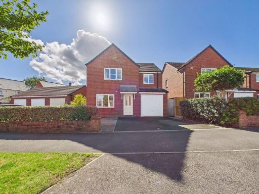 4 bedroom detached house for sale in 1 Greenfields Drive, Newport, TF10 — £355,000 • 4 bed • 2 bath • 1153 ft²
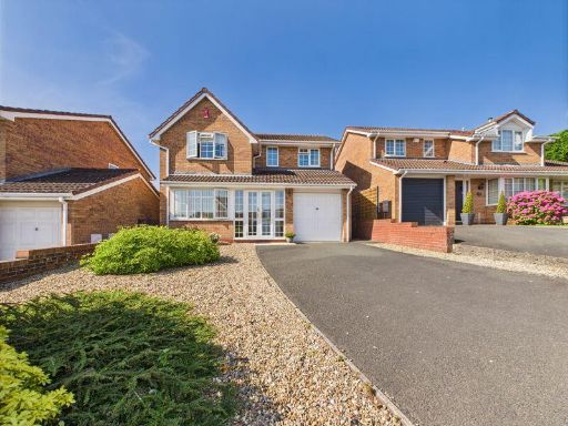 4 bedroom detached house for sale in 5 Swanmere, Newport, TF10 — £379,950 • 4 bed • 2 bath • 1178 ft²
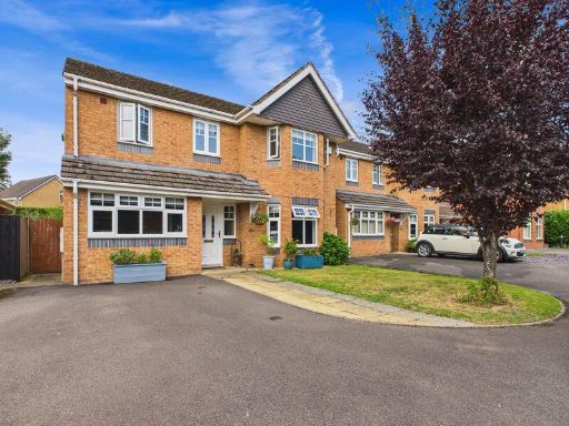 4 bedroom detached house for sale in Swanmere, Newport, TF10 — £469,995 • 4 bed • 3 bath • 1582 ft²
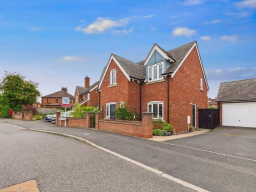 4 bedroom detached house for sale in Derwent House, Audley Road, Newport, TF10 — £430,000 • 4 bed • 2 bath • 640 ft²
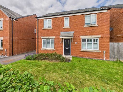 4 bedroom detached house for sale in 5 Centenary Way, Newport, TF10 — £359,950 • 4 bed • 2 bath • 536 ft²
Meta
- {
"@context": "https://schema.org",
"@type": "Residence",
"name": "4 bedroom detached house for sale in 36 Fair Oak, Newport,…",
"description": "",
"url": "https://propertypiper.co.uk/property/45caba33-c10f-413d-be25-98af01a73d55",
"image": "https://image-a.propertypiper.co.uk/ce9062f3-64f9-4938-ad33-927d42ab5603-1024.jpeg",
"address": {
"@type": "PostalAddress",
"streetAddress": "36 FAIR OAK NEWPORT",
"postalCode": "TF10 7LR",
"addressLocality": "Telford and Wrekin",
"addressRegion": "The Wrekin",
"addressCountry": "England"
},
"geo": {
"@type": "GeoCoordinates",
"latitude": 52.777333589342604,
"longitude": -2.3749522385272535
},
"numberOfRooms": 4,
"numberOfBathroomsTotal": 2,
"floorSize": {
"@type": "QuantitativeValue",
"value": 1145,
"unitCode": "FTK"
},
"offers": {
"@type": "Offer",
"price": 439950,
"priceCurrency": "GBP",
"availability": "https://schema.org/InStock"
},
"additionalProperty": [
{
"@type": "PropertyValue",
"name": "Feature",
"value": "detached"
},
{
"@type": "PropertyValue",
"name": "Feature",
"value": "suburban"
},
{
"@type": "PropertyValue",
"name": "Feature",
"value": "1980s"
},
{
"@type": "PropertyValue",
"name": "Feature",
"value": "brick"
},
{
"@type": "PropertyValue",
"name": "Feature",
"value": "garage"
},
{
"@type": "PropertyValue",
"name": "Feature",
"value": "garden"
},
{
"@type": "PropertyValue",
"name": "Feature",
"value": "driveway"
},
{
"@type": "PropertyValue",
"name": "Feature",
"value": "family home"
},
{
"@type": "PropertyValue",
"name": "Feature",
"value": "residential area"
},
{
"@type": "PropertyValue",
"name": "Feature",
"value": "large garden"
},
{
"@type": "PropertyValue",
"name": "Feature",
"value": "outdoor space"
},
{
"@type": "PropertyValue",
"name": "Feature",
"value": "patio"
},
{
"@type": "PropertyValue",
"name": "Feature",
"value": "landscaped"
},
{
"@type": "PropertyValue",
"name": "Feature",
"value": "deck area"
},
{
"@type": "PropertyValue",
"name": "Feature",
"value": "lawn"
}
]
}
High Res Floorplan Images
Compatible Floorplan Images
FloorplanImages Thumbnail