CV34 4UU - 2 bedroom retirement property for sale in Pickard Street, W…
View on Property Piper
2 bedroom retirement property for sale in Pickard Street, Warwick, CV34
Property Details
- Price: £100000
- Bedrooms: 2
- Bathrooms: 1
- Property Type: undefined
- Property SubType: undefined
Brochure Descriptions
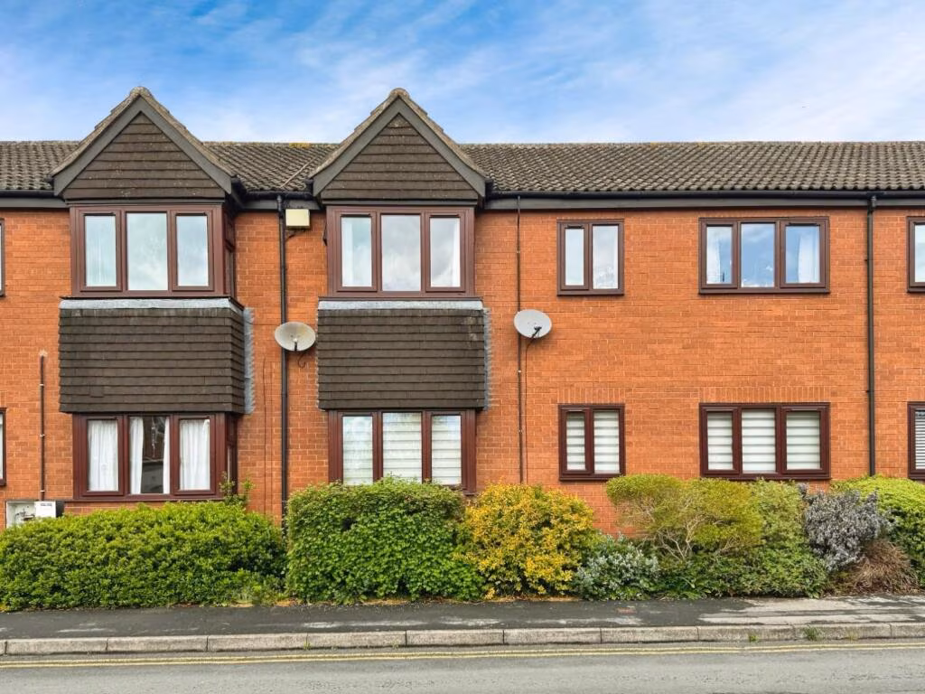
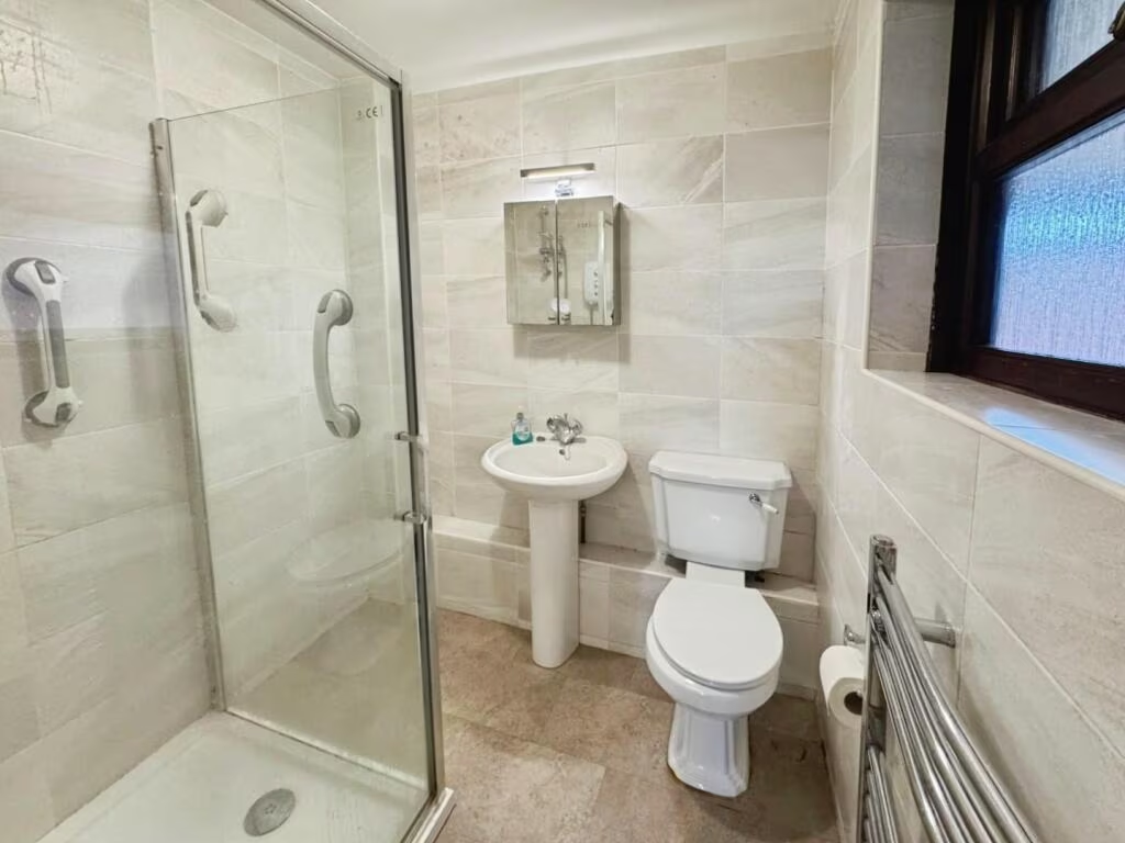
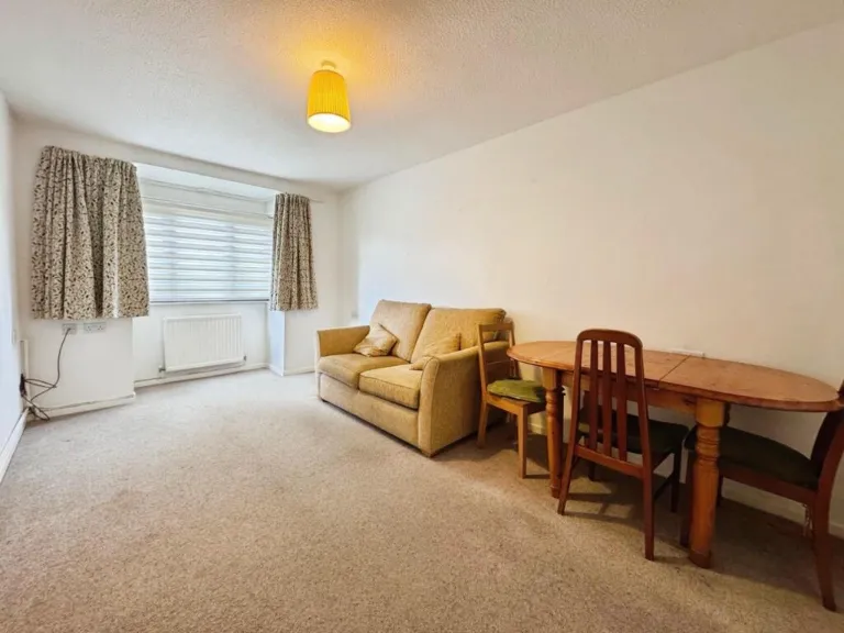
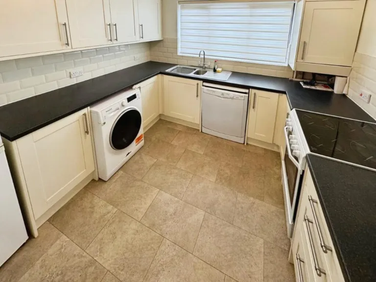
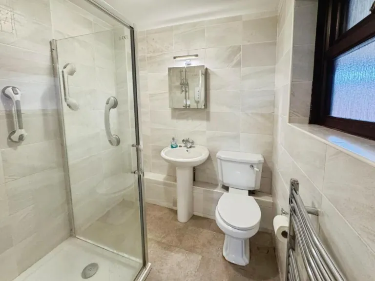
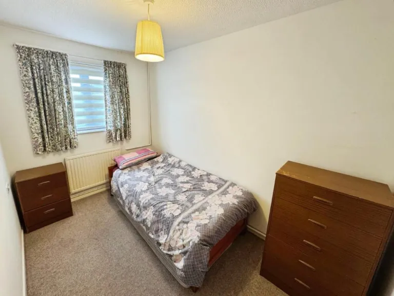
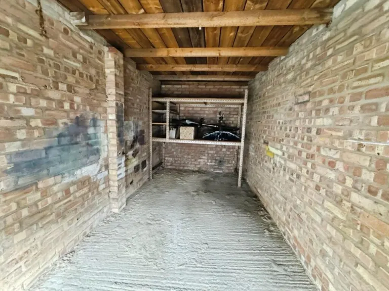
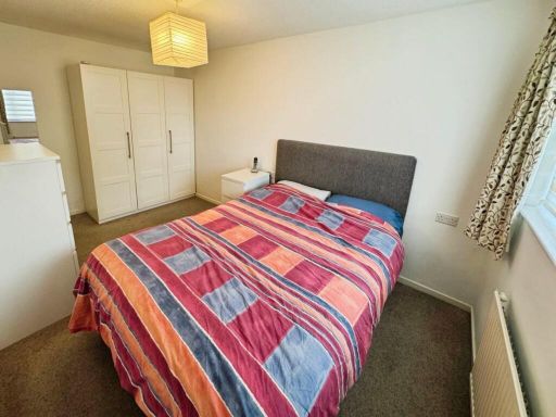
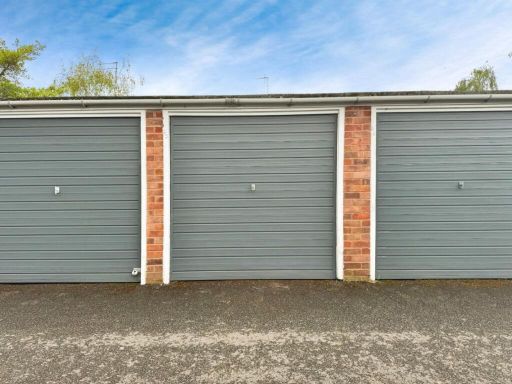
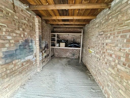
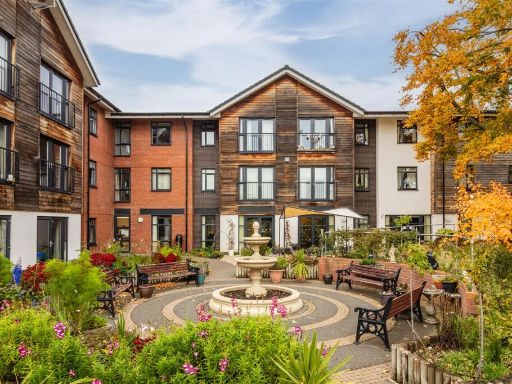
- This residential property is a ground floor, two-bedroom apartment designed for individuals over 55 years old. It features easy accessibility to local amenities, being conveniently situated close to St Nicholas Park and Warwick train station. The property is thought to be part of a communal building, evident from the multiple uniform windows and doors, possibly indicating multiple units. The exterior is characterized by red brick construction and gabled roof designs, suggesting a typical suburban setting. The front garden is modestly sized, with hedges providing some privacy from the street. Internally, the apartment includes a fitted kitchen and shower room, with a living room that benefits from multiple windows conducive to ample natural light. Overall, the property can be classified as average-sized for an apartment, catering specifically to older demographics who prefer convenience in proximity to essential services.
Image Descriptions
- terraced house modern
- living room 1980s build
Textual Property Features
- Is Shared Ownership
- Chain Free
- Is Retirement
- Success
Detected Visual Features
- modern terraced house
- brick facade
- dual satellite dishes
- double glazed windows
- pitched roof
- residential area
- 1980s
- medium room
- standard ceiling
- dated interior
- bay window
- natural light
- carpeted floor
Nearby Schools
- Whitnash Primary School
- Shrubland Street Community Primary School
- Woodloes Primary School
- Brookhurst Primary School
- Arnold Lodge School
- Oakley School
- King's High School
- Kingsway Community Primary School
- The Emscote School
- The Kingsley School
- All Saints Church of England Academy
- Heathcote Primary School
- Newburgh Primary School
- St Patrick's Catholic Primary School
- Warwick Preparatory School
- Coten End Primary School
- St Mary Immaculate Catholic Primary School
- Emscote Infant School
- All Saints' CofE Junior School
- Trinity Catholic School
- Bishops Tachbrook CofE Primary School
- Aylesford School Warwick
- Warwick School
- Myton School
- Westgate Primary School
- St Peter's Catholic Primary School
- Milverton Primary School
Nearest General Shops
- Id: 256348704
- Tags:
- Addr:
- City: Warwick
- Postcode: CV34 4PH
- Street: Emscote Road
- Brand: Halfords Autocentre
- Brand:wikidata: Q5641894
- Brand:wikipedia: en:Halfords Autocentre
- Building: industrial
- Name: Halfords Autocentre
- Opening_hours: Mo-Fr 08:00-18:00; Sa 08:00-17:00
- Shop: car_repair
- Wheelchair: yes
- TagsNormalized:
- autocentre
- halfords
- halfords autocentre
- industrial
- car repair
- repair
- shop
- Lat: 52.2860601
- Lon: -1.5721102
- FullGeoHash: gcqcknrhrhj9
- PartitionGeoHash: gcqc
- Images:
- FoodStandards: null
- Distance: 101.9
,- Id: 4549542044
- Tags:
- Addr:
- City: Warwick
- Housenumber: 30
- Postcode: CV34 4PP
- Street: Emscote Road
- Name: Baileys of Warwick
- Opening_hours: Mo-Sa 08:00-16:00
- Shop: fishing
- Website: https://www.baileysofwarwick.com/
- Wheelchair: no
- TagsNormalized:
- Lat: 52.2856686
- Lon: -1.5728216
- FullGeoHash: gcqcknqdne54
- PartitionGeoHash: gcqc
- Images:
- FoodStandards: null
- Distance: 71
,- Id: 2626265984
- Tags:
- Addr:
- City: Warwick
- Housenumber: 44
- Postcode: CV34 4QP
- Street: Emscote Road
- Name: Headfirst
- Opening_hours: Mo-Fr 09:00-17:30; Sa 08:00-16:00
- Shop: hairdresser
- Wheelchair: no
- TagsNormalized:
- Lat: 52.2857623
- Lon: -1.5722375
- FullGeoHash: gcqcknr4shw9
- PartitionGeoHash: gcqc
- Images:
- FoodStandards: null
- Distance: 68.5
}
Nearest Religious buildings
- Id: 55280746
- Tags:
- Addr:
- City: Warwick
- Postcode: CV34 4JD
- Street: St Nicholas Church Street
- Amenity: place_of_worship
- Building: church
- Denomination: anglican
- Fhrs:
- Heritage: 2
- Heritage:operator: Historic England
- Listed_status: Grade I
- Name: St Nicholas
- Religion: christian
- Source: OS_OpenData_StreetView
- Website: http://www.stnicholaswarwick.org.uk/
- Wheelchair: yes
- Wikidata: Q17528541
- TagsNormalized:
- place of worship
- church
- anglican
- christian
- Lat: 52.2817969
- Lon: -1.5818067
- FullGeoHash: gcqckj85t1r6
- PartitionGeoHash: gcqc
- Images:
- FoodStandards:
- Id: 241657
- FHRSID: 241657
- LocalAuthorityBusinessID: 1579
- BusinessName: St Nicholas Church
- BusinessType: Other catering premises
- BusinessTypeID: 7841
- AddressLine1: St Nicholas Church
- AddressLine2: St Nicholas Church Street
- AddressLine3: null
- AddressLine4: Warwick
- PostCode: CV34 4JD
- RatingValue: 5
- RatingKey: fhrs_5_en-GB
- RatingDate: 2023-01-26
- LocalAuthorityCode: 321
- LocalAuthorityName: Warwick
- LocalAuthorityWebSite: http://www.warwickdc.gov.uk
- LocalAuthorityEmailAddress: foodsafety@warwickdc.gov.uk
- Scores:
- Hygiene: 5
- Structural: 0
- ConfidenceInManagement: 5
- NewRatingPending: false
- Geocode:
- Longitude: -1.58234560489655
- Latitude: 52.28251266479492
- Distance: 750.9
,- Id: 244136188
- Tags:
- Amenity: place_of_worship
- Building: church
- Religion: christian
- Source: bing
- TagsNormalized:
- place of worship
- church
- christian
- Lat: 52.2794854
- Lon: -1.5732537
- FullGeoHash: gcqckjnqhd3j
- PartitionGeoHash: gcqc
- Images:
- FoodStandards: null
- Distance: 633.3
,- Id: 332914158
- Tags:
- Addr:
- City: Warwick
- Postcode: CV34 5NL
- Street: Vicarage Field
- Amenity: place_of_worship
- Building: church
- Denomination: anglican
- Name: All Saints
- Religion: christian
- Source: survey
- Website: https://www.allsaintsemscote.com/
- Wikidata: Q105094342
- TagsNormalized:
- place of worship
- church
- anglican
- christian
- Lat: 52.2890419
- Lon: -1.5673317
- FullGeoHash: gcqckqftwxbu
- PartitionGeoHash: gcqc
- Images:
- FoodStandards: null
- Distance: 546.2
}
Nearest Medical buildings
- Id: 256521775
- Tags:
- Amenity: doctors
- Building: yes
- Healthcare: doctor
- Name: Avonside Health Centre
- TagsNormalized:
- doctor
- doctors
- health
- healthcare
- health centre
- Lat: 52.289267
- Lon: -1.5607028
- FullGeoHash: gcqckqzx0cze
- PartitionGeoHash: gcqc
- Images:
- FoodStandards: null
- Distance: 907.7
,- Id: 2619137082
- Tags:
- Amenity: clinic
- Check_date: 2022-06-23
- Health_specialty:
- Healthcare: clinic
- Healthcare:speciality: chiropractic
- Name: Leamington Spa & Redditch Chiropractic Clinic
- Opening_hours: Tu,Th 09:00-12:30, Tu 14:00-19:00, Fr 08:00-12:30, Sa 08:00-12:00, Th,Fr 14:00-18:00
- Phone: +44 1926 427354
- Website: https://www.leamingtonchiropractic.co.uk/
- Wheelchair: yes
- TagsNormalized:
- clinic
- chiropractic
- health
- healthcare
- spa
- Lat: 52.2931031
- Lon: -1.5700388
- FullGeoHash: gcqckr8trkyn
- PartitionGeoHash: gcqc
- Images:
- FoodStandards: null
- Distance: 897.2
,- Id: 244966191
- Tags:
- Amenity: hospital
- Healthcare: hospital
- Source: bing
- TagsNormalized:
- Lat: 52.2899093
- Lon: -1.5814069
- FullGeoHash: gcqckp06y99d
- PartitionGeoHash: gcqc
- Images:
- FoodStandards: null
- Distance: 819.1
,- Id: 5169934116
- Tags:
- Addr:
- Postcode: CV34 5QJ
- Street: Emscote Road
- Amenity: pharmacy
- Healthcare: pharmacy
- Operator: Tesco
- Ref: 1079754
- TagsNormalized:
- Lat: 52.2861032
- Lon: -1.5629733
- FullGeoHash: gcqckqmush4d
- PartitionGeoHash: gcqc
- Images:
- FoodStandards: null
- Distance: 638
}
Nearest Airports
- Id: 2437117
- Tags:
- Aerodrome: international
- Aerodrome:type: public
- Aeroway: aerodrome
- Ele: 104
- Iata: BHX
- Icao: EGBB
- Internet_access: wlan
- Is_in: Birmingham,England,UK
- Name: Birmingham Airport
- Ref: BHX
- Type: multipolygon
- Website: https://www.birminghamairport.co.uk/
- Wikidata: Q8719
- Wikipedia: en:Birmingham Airport
- TagsNormalized:
- airport
- international airport
- Lat: 52.4543817
- Lon: -1.7468974
- FullGeoHash: gcqf2jpbym6y
- PartitionGeoHash: gcqf
- Images:
- FoodStandards: null
- Distance: 22243.2
}
Nearest Leisure Facilities
- Id: 943243010
- Tags:
- Access: customers
- Beer_garden: yes
- Garden:
- Leisure: garden
- Operator: Black Pug
- Operator:type: private_for_profit
- TagsNormalized:
- Lat: 52.2855664
- Lon: -1.5774389
- FullGeoHash: gcqckn73e002
- PartitionGeoHash: gcqc
- Images:
- FoodStandards: null
- Distance: 358
,- Id: 26820961
- Tags:
- Leisure: fishing
- Name: Kingfisher Pool
- Natural: water
- Water: pond
- TagsNormalized:
- Lat: 52.2822248
- Lon: -1.5707581
- FullGeoHash: gcqckm8nn9jf
- PartitionGeoHash: gcqc
- Images:
- FoodStandards: null
- Distance: 339.7
,- Id: 588430042
- Tags:
- Leisure: park
- Name: Saint Nicholas Park
- Wikidata: Q7590810
- Wikipedia: en:St Nicholas' Park, Warwick
- TagsNormalized:
- Lat: 52.282494
- Lon: -1.5725531
- FullGeoHash: gcqckjwzsg72
- PartitionGeoHash: gcqc
- Images:
- FoodStandards: null
- Distance: 295.8
,- Id: 256472659
- Tags:
- TagsNormalized:
- Lat: 52.2875879
- Lon: -1.5715427
- FullGeoHash: gcqcknxtk2ug
- PartitionGeoHash: gcqc
- Images:
- FoodStandards: null
- Distance: 275.4
,- Id: 625662818
- Tags:
- Access: yes
- Highway: service
- Leisure: slipway
- Service: slipway
- TagsNormalized:
- Lat: 52.2830257
- Lon: -1.5717804
- FullGeoHash: gcqckjz6wy7s
- PartitionGeoHash: gcqc
- Images:
- FoodStandards: null
- Distance: 237.7
}
Nearest Tourist attractions
- Id: 423271976
- Tags:
- Addr:
- City: Warwick
- Housenumber: 74
- Postcode: CV34 5QG
- Street: Emscote Road
- Building: residential
- Fhrs:
- Name: Ashburton Guest House
- Source: Warwicks CC Aerial Imagery 2013
- Tourism: guest_house
- TagsNormalized:
- residential
- guest house
- tourism
- Lat: 52.2863819
- Lon: -1.5688221
- FullGeoHash: gcqckq3w7b13
- PartitionGeoHash: gcqc
- Images:
- FoodStandards: null
- Distance: 269
,- Id: 256084315
- Tags:
- Addr:
- City: Warwick
- Housenumber: 7
- Postcode: CV34 4PH
- Street: Emscote Road
- Building: yes
- Internet_access: wlan
- Name: Avon Guest House
- Tourism: guest_house
- Website: http://www.avonguesthouse.gbr.cc/
- Wheelchair: no
- TagsNormalized:
- Lat: 52.2855029
- Lon: -1.5750564
- FullGeoHash: gcqcknm14s0v
- PartitionGeoHash: gcqc
- Images:
- FoodStandards: null
- Distance: 196.9
,- Id: 257010584
- Tags:
- Addr:
- City: Warwick
- Housenumber: 17
- Postcode: CV34 4PH
- Street: Emscote Road
- Building: yes
- Fhrs:
- Internet_access: wlan
- Name: Park House Guest House
- Tourism: guest_house
- Website: http://www.warwickparkhouse.co.uk/
- Wheelchair: no
- TagsNormalized:
- Lat: 52.2856863
- Lon: -1.5744792
- FullGeoHash: gcqcknm6pyr5
- PartitionGeoHash: gcqc
- Images:
- FoodStandards: null
- Distance: 164.9
}
Nearest Hotels
- Id: 256288433
- Tags:
- Addr:
- City: Warwick
- Housenumber: 17;19;21
- Postcode: CV34 4AT
- Street: High Street
- Building: yes
- Check_date: 2022-05-23
- Email: reception@warwickarmshotel.com
- Fhrs:
- Heritage: 2
- Heritage:operator: Historic England
- Listed_status: Grade II
- Name: Warwick Arms Hotel
- Phone: +44 1926 492759
- Source: Bing
- Tourism: hotel
- Url: http://www.warwickarmshotel.com/
- Website: https://www.warwicksarmshotel.com/
- Wikidata: Q26287043
- TagsNormalized:
- Lat: 52.2806584
- Lon: -1.5883664
- FullGeoHash: gcqc7v7kumh5
- PartitionGeoHash: gcqc
- Images:
- FoodStandards: null
- Distance: 1206.3
,- Id: 256057049
- Tags:
- Addr:
- City: Warwick
- Housenumber: 2-4
- Postcode: CV34 4LJ
- Street: Coventry Road
- Building: yes
- Fhrs:
- Name: Castle Limes Hotel
- Source: bing
- Tourism: hotel
- Website: http://www.castlelimeshotel.co.uk/
- TagsNormalized:
- Lat: 52.2840267
- Lon: -1.5803343
- FullGeoHash: gcqckn10x8cr
- PartitionGeoHash: gcqc
- Images:
- FoodStandards: null
- Distance: 565.7
,- Id: 423198950
- Tags:
- Addr:
- City: Warwick
- Housenumber: 20a-20b
- Postcode: CV34 4PP
- Street: Emscote Road
- Building: residential
- Fhrs:
- Name: Cambridge Villa Hotel
- Source: Warwicks CC Aerial Imagery 2013
- Tourism: hotel
- Website: http://www.cambridge-villa-warwick.co.uk/
- Wheelchair: no
- TagsNormalized:
- Lat: 52.2854557
- Lon: -1.5731114
- FullGeoHash: gcqcknq2zg7h
- PartitionGeoHash: gcqc
- Images:
- FoodStandards: null
- Distance: 69.6
}
Tags
- modern terraced house
- brick facade
- dual satellite dishes
- double glazed windows
- pitched roof
- residential area
- 1980s
- medium room
- standard ceiling
- dated interior
- bay window
- natural light
- carpeted floor
Local Market Stats
- Average Price/sqft: £351
- Avg Income: £51300
- Rental Yield: 4.3%
- Social Housing: 16%
- Planning Success Rate: 89%
AirBnB Data
- 1km average: £83/night
- Listings in 1km: 5
Similar Properties
 2 bedroom apartment for sale in All Saints Road, Warwick, CV34 — £61,500 • 2 bed • 1 bath • 679 ft²
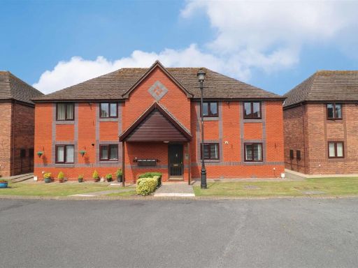 2 bedroom retirement property for sale in Holioake Drive, Warwick, CV34 — £185,000 • 2 bed • 1 bath • 588 ft²
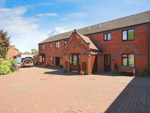 1 bedroom flat for sale in Priory Walk, Cross Street, Warwick, Warwickshire, CV34 — £110,000 • 1 bed • 1 bath • 437 ft²
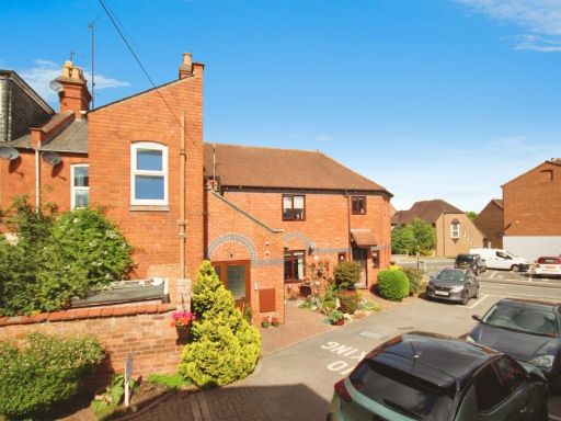 1 bedroom flat for sale in Priory Walk, Cross Street, Warwick, Warwickshire, CV34 — £120,000 • 1 bed • 1 bath • 489 ft²
 2 bedroom retirement property for sale in Garden Court, Priory Road, Warwick, CV34 — £149,950 • 2 bed • 1 bath • 593 ft²
 2 bedroom flat for sale in Turberville Place, Warwick, CV34 — £93,500 • 2 bed • 1 bath • 700 ft²
Meta
- {
"@context": "https://schema.org",
"@type": "Residence",
"name": "2 bedroom retirement property for sale in Pickard Street, W…",
"description": "",
"url": "https://propertypiper.co.uk/property/38a92b1e-6b2a-41eb-8f24-a751eab70640",
"image": "https://image-a.propertypiper.co.uk/26541828-de20-4507-9165-03e17cd0f265-1024.jpeg",
"address": {
"@type": "PostalAddress",
"streetAddress": "Pickard Street, Warwick",
"postalCode": "CV34 4UU",
"addressLocality": "Warwick",
"addressRegion": "Warwick and Leamington",
"addressCountry": "England"
},
"geo": {
"@type": "GeoCoordinates",
"latitude": 52.28514600929731,
"longitude": -1.5722216313956667
},
"numberOfRooms": 2,
"numberOfBathroomsTotal": 1,
"floorSize": {
"@type": "QuantitativeValue",
"value": 426,
"unitCode": "FTK"
},
"offers": {
"@type": "Offer",
"price": 100000,
"priceCurrency": "GBP",
"availability": "https://schema.org/InStock"
},
"additionalProperty": [
{
"@type": "PropertyValue",
"name": "Feature",
"value": "modern terraced house"
},
{
"@type": "PropertyValue",
"name": "Feature",
"value": "brick facade"
},
{
"@type": "PropertyValue",
"name": "Feature",
"value": "dual satellite dishes"
},
{
"@type": "PropertyValue",
"name": "Feature",
"value": "double glazed windows"
},
{
"@type": "PropertyValue",
"name": "Feature",
"value": "pitched roof"
},
{
"@type": "PropertyValue",
"name": "Feature",
"value": "residential area"
},
{
"@type": "PropertyValue",
"name": "Feature",
"value": "1980s"
},
{
"@type": "PropertyValue",
"name": "Feature",
"value": "medium room"
},
{
"@type": "PropertyValue",
"name": "Feature",
"value": "standard ceiling"
},
{
"@type": "PropertyValue",
"name": "Feature",
"value": "dated interior"
},
{
"@type": "PropertyValue",
"name": "Feature",
"value": "bay window"
},
{
"@type": "PropertyValue",
"name": "Feature",
"value": "natural light"
},
{
"@type": "PropertyValue",
"name": "Feature",
"value": "carpeted floor"
}
]
}