NE65 8RF - 7 bedroom country house for sale in Ghyllheugh Estate, Long…
View on Property Piper
7 bedroom country house for sale in Ghyllheugh Estate, Longhorsley, Morpeth, Northumberland, NE65
Property Details
- Price: £7500000
- Bedrooms: 7
- Bathrooms: 6
- Property Type: undefined
- Property SubType: undefined
Brochure Descriptions
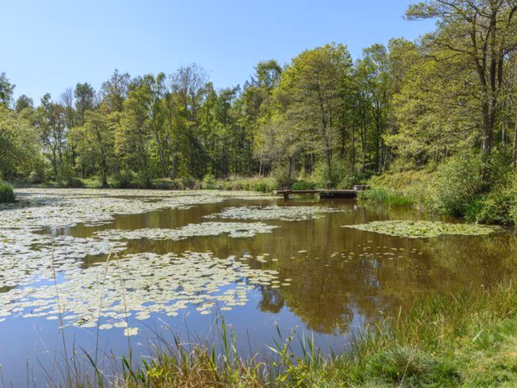
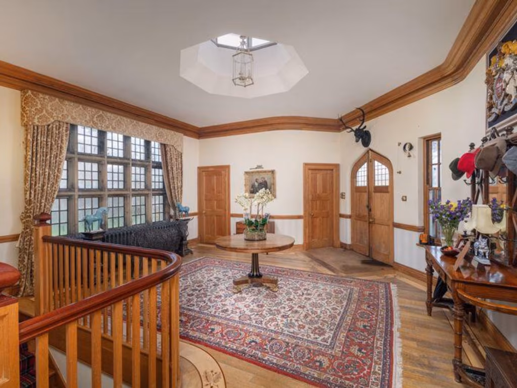
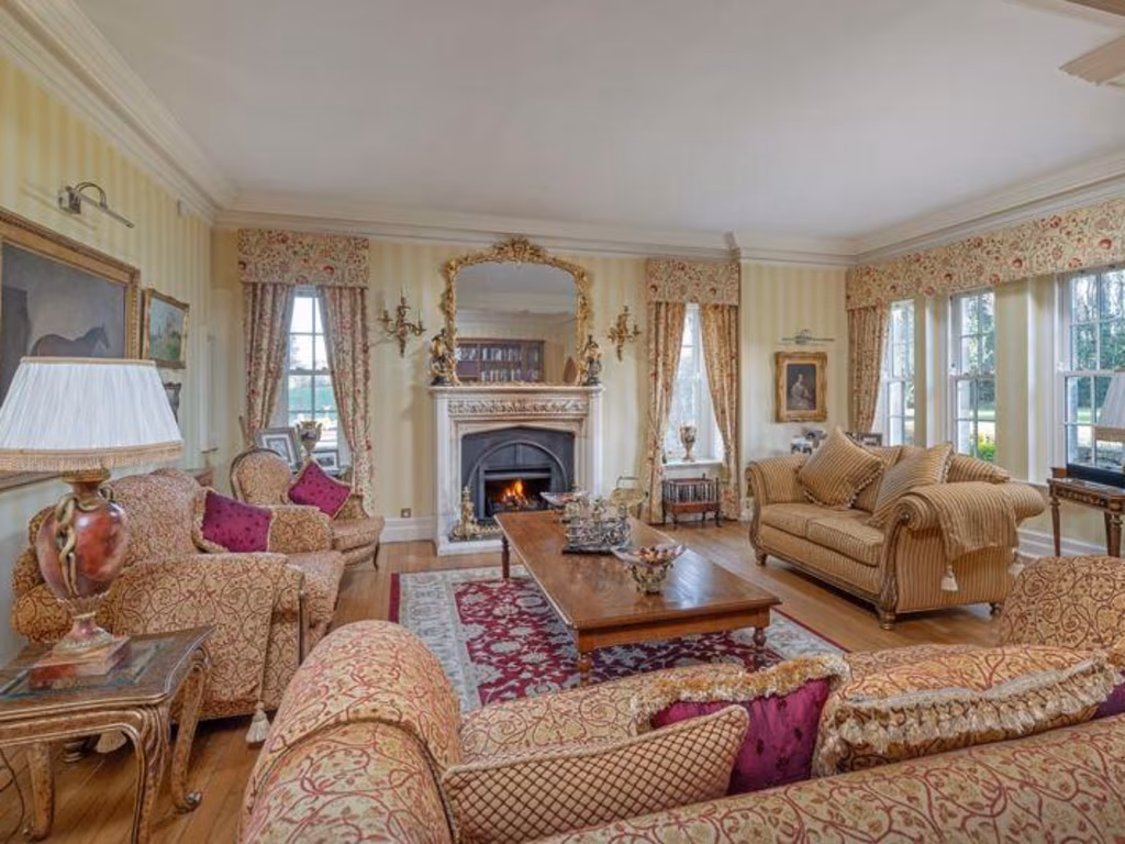
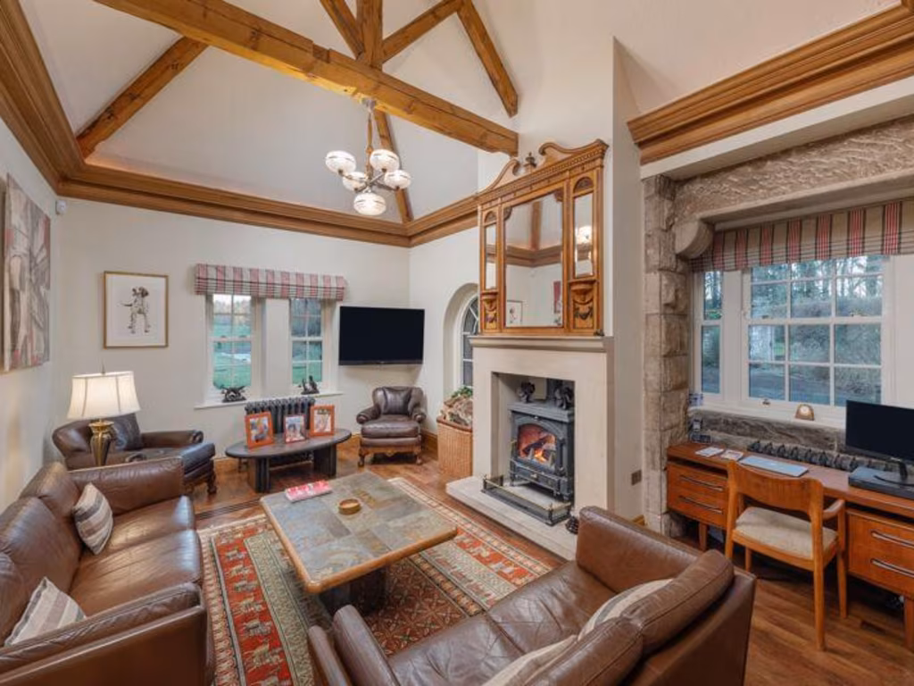
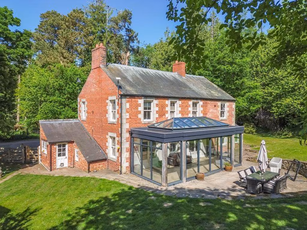
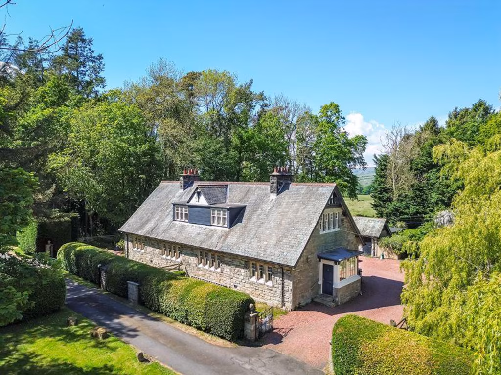
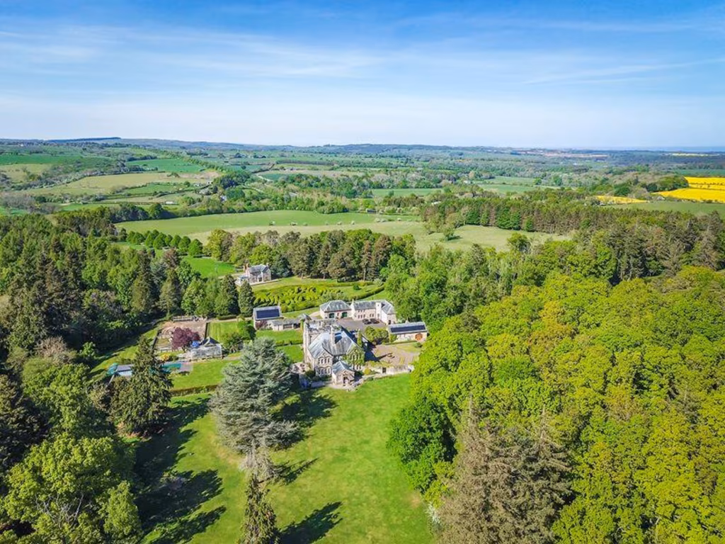
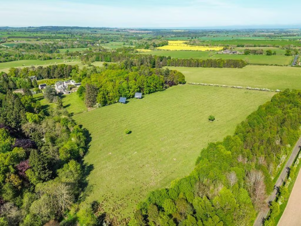
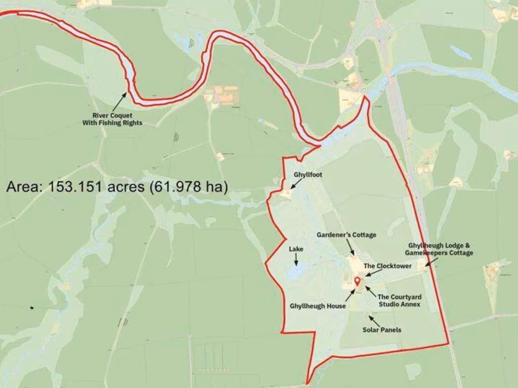
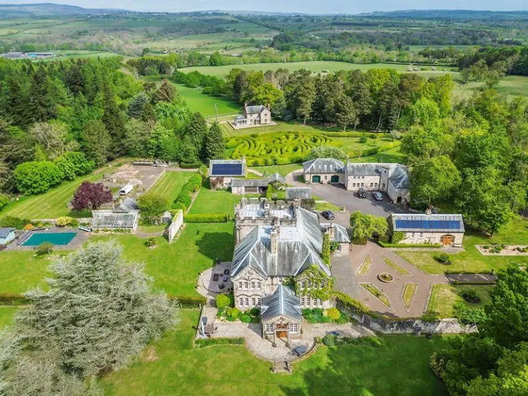
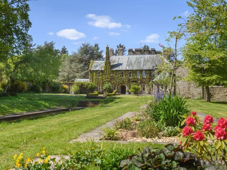
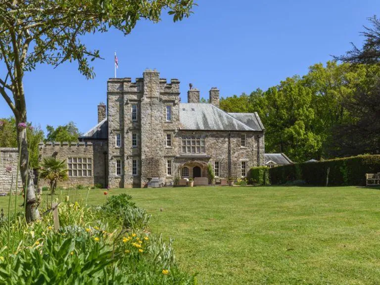
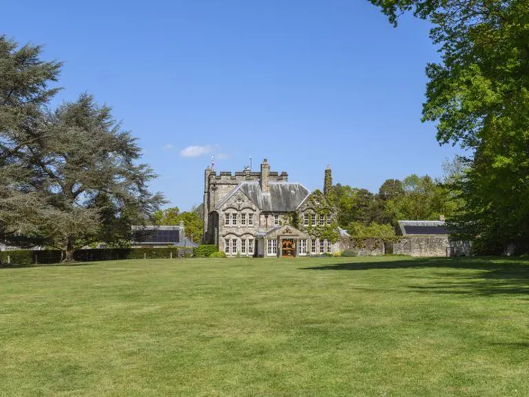
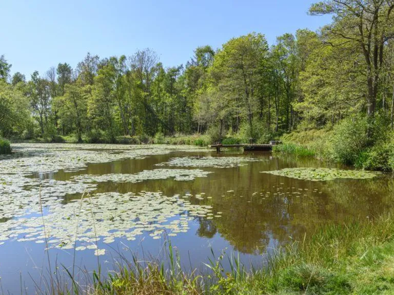
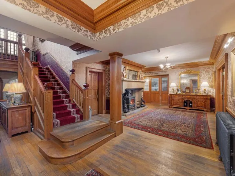
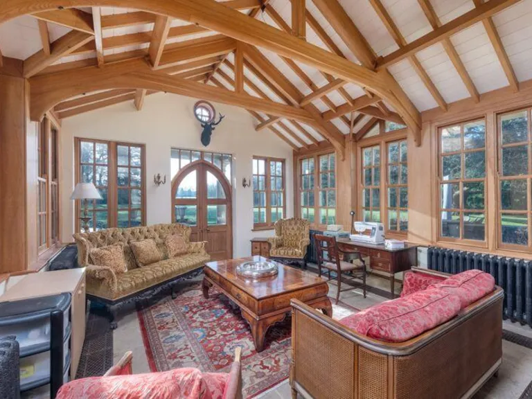
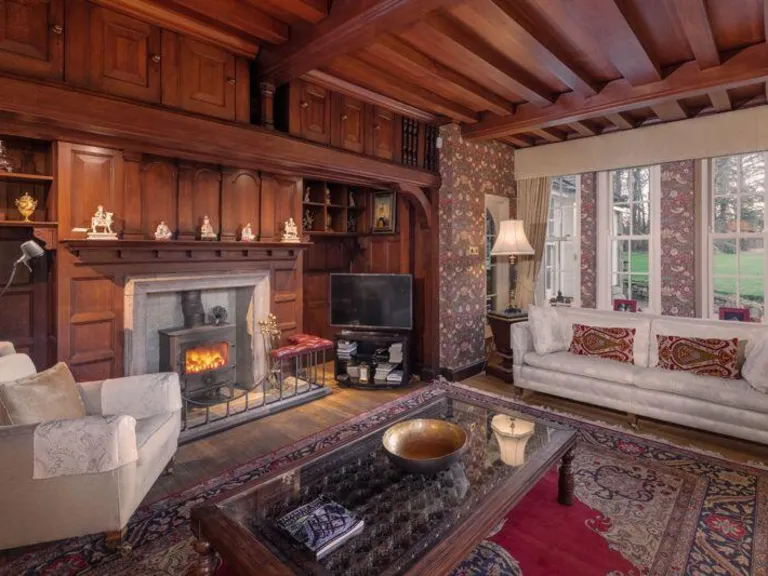
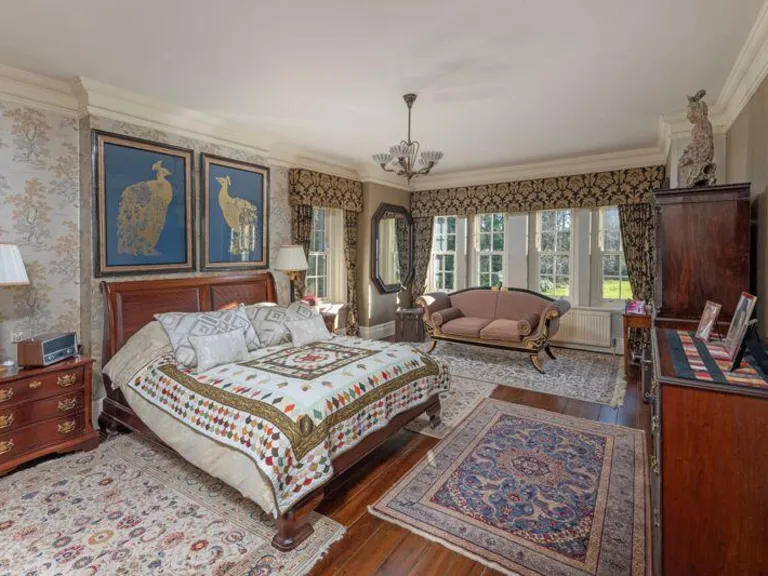
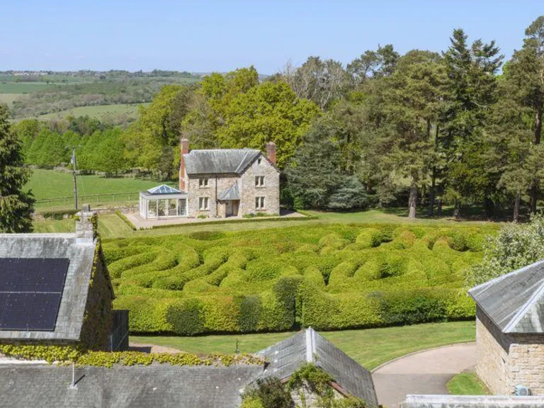
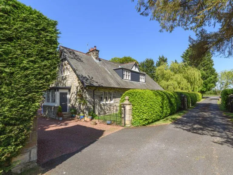
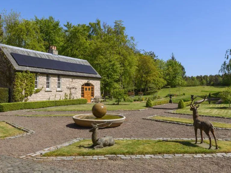
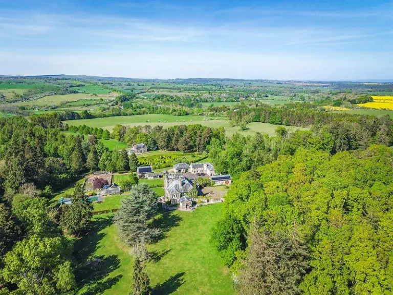
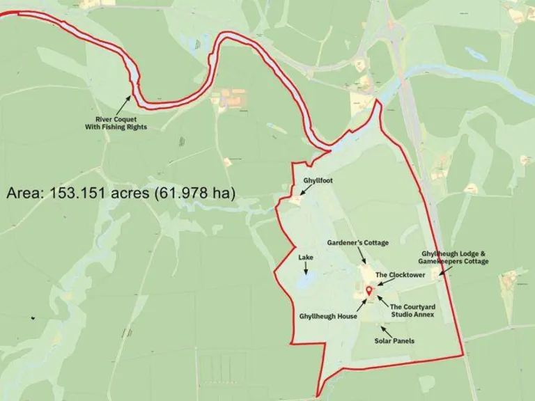
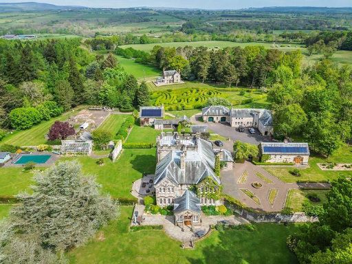
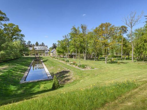
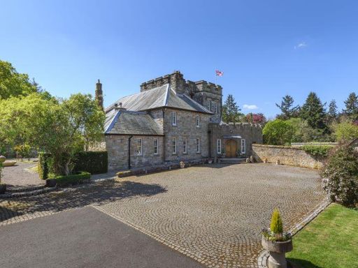
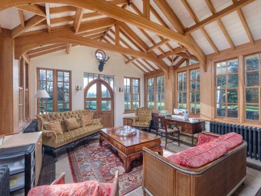
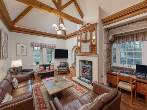
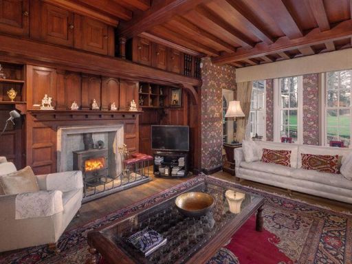
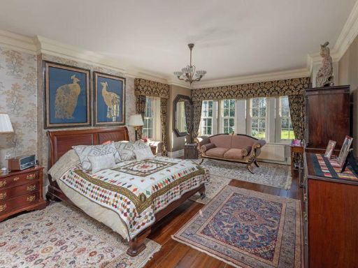
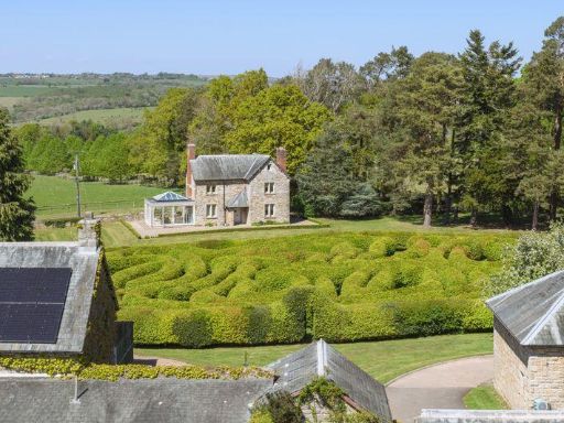
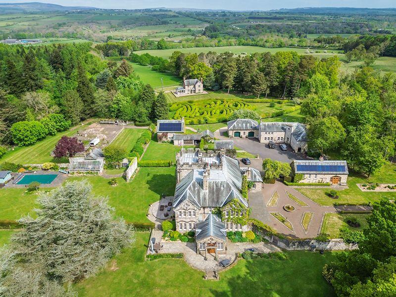
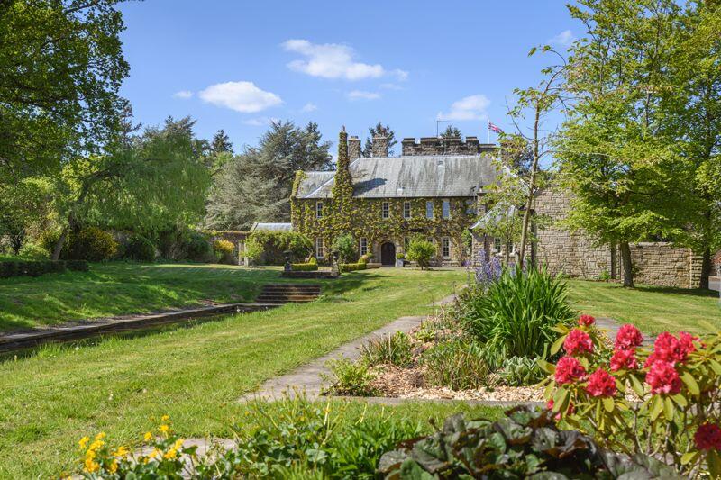
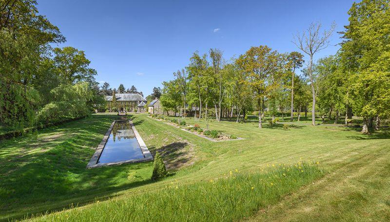
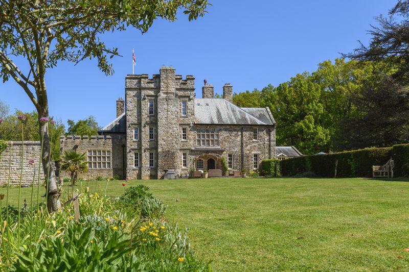
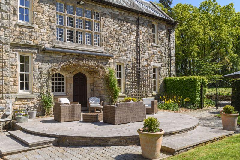
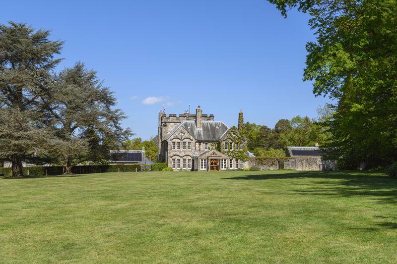
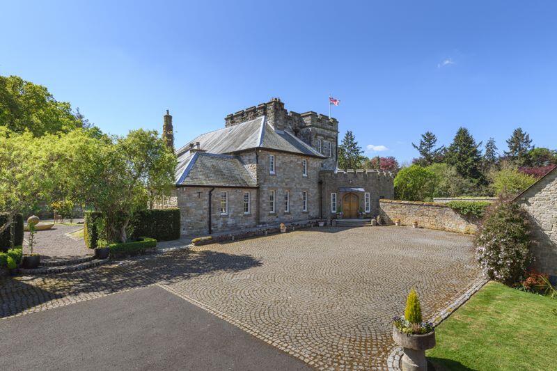
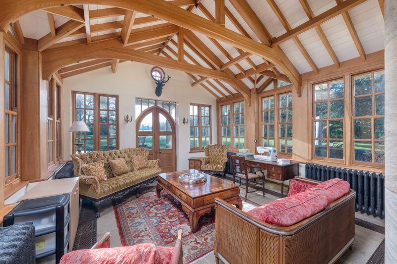
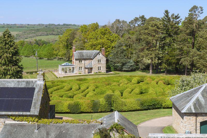
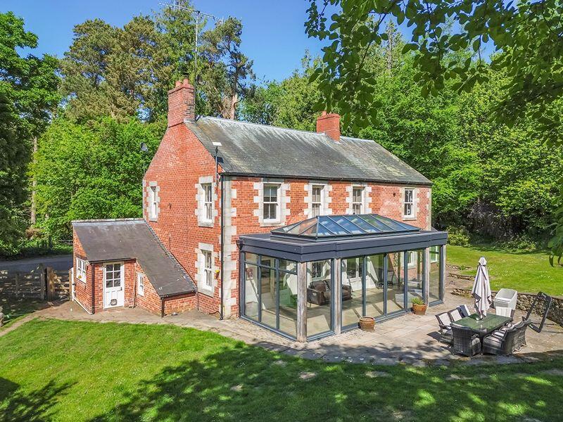
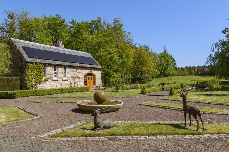
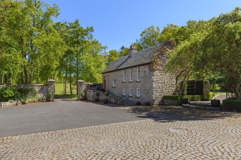
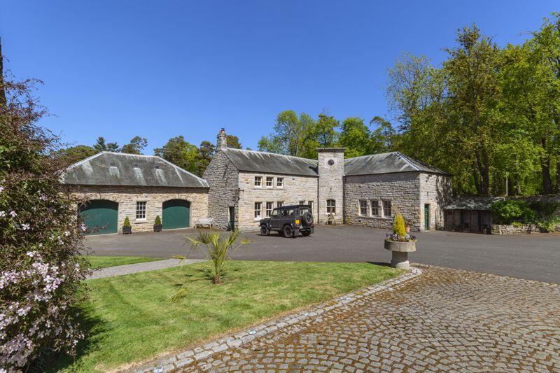
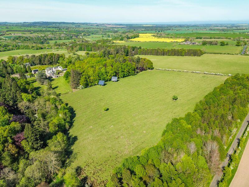
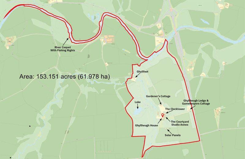
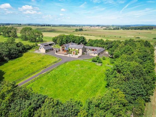
- The property is part of the Ghyllheugh Estate, characterized by a historic architectural style resembling a small castle or stately home. The building features traditional stonework, classic turrets, and detailed masonry, indicative of an estate with significant heritage and possibly sprawling grounds. While the exact size cannot be determined from the image alone, such properties typically boast large internal spaces, with extensive gardens or natural surrounding, offering exceptional views of the Northumberland countryside.
Image Descriptions
- estate Georgian
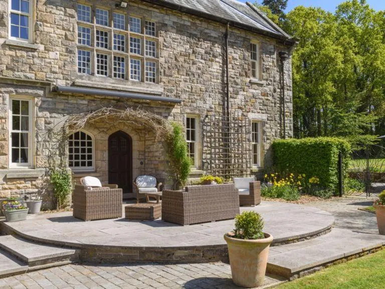
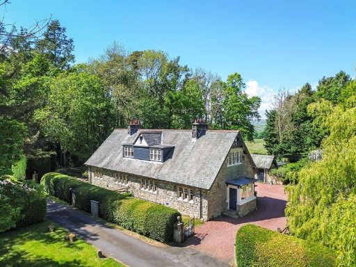
- property exterior Victorian
Floorplan Description
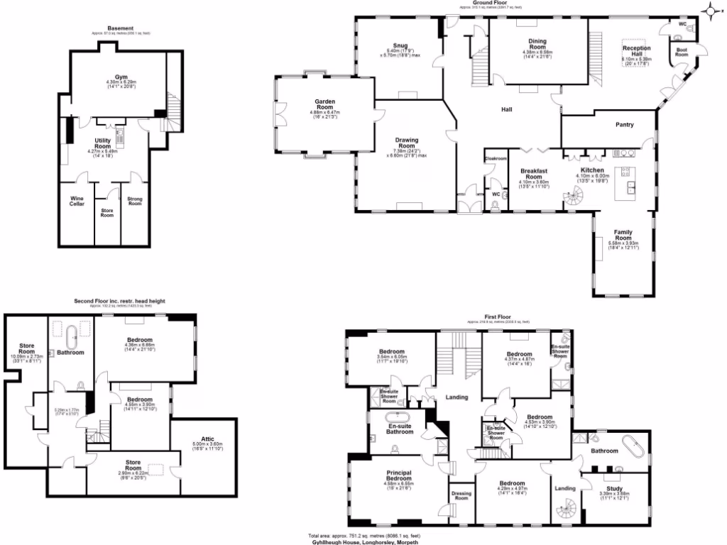
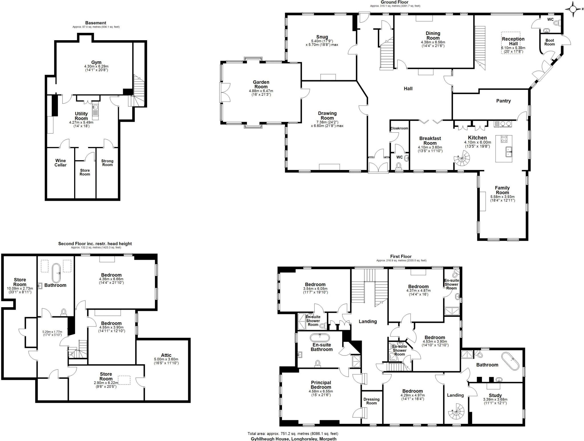
- A large multi-story house with a basement, multiple bedrooms, living areas, and utility rooms.
Rooms
- Gym: Average
- Utility Room: Small
- Wine Cellar: Small
- Store Room: Small
- Storng Room: Small
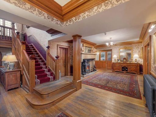
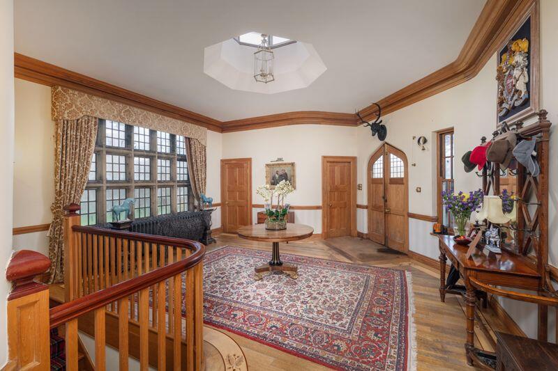
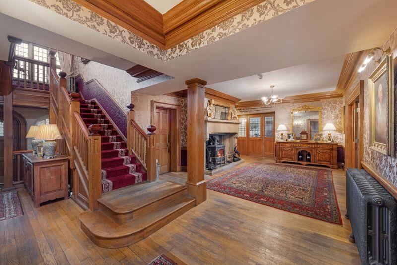
- Reception Hall: Large
- Boot Room: Small
- Ground Room: Average
- Dining Room: Average
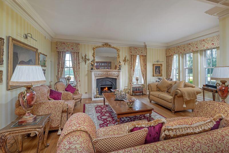
- Drawing Room: Large
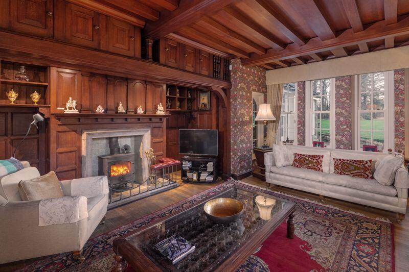
- Snug: Small
- WC: Small
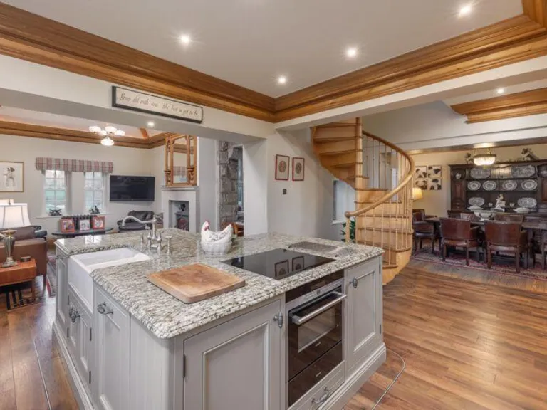
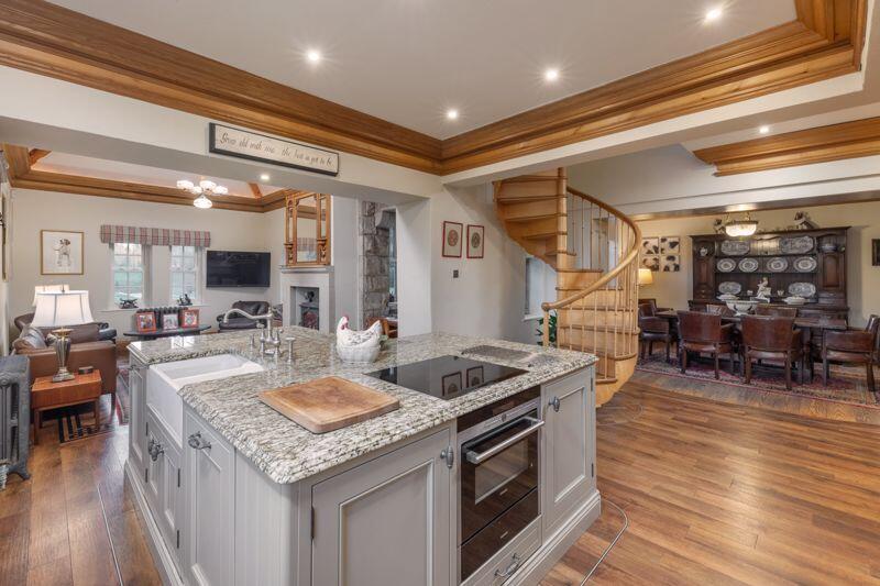
- Kitchen: Large
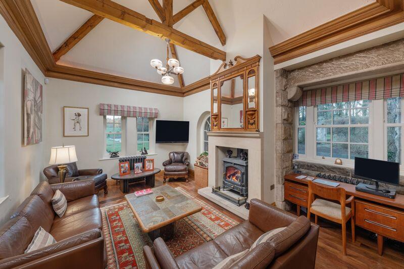
- Family Room: Average
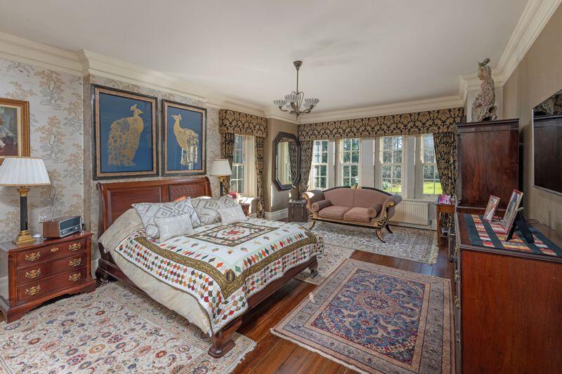
- Bedroom: Average
- Bedroom: Average
- Principal Bedroom: Average
- Bedroom: Small
- Bedroom: Small
- Dressing Room: Small
- Study: Small
- Store Room: Average
- Storng Room: Small
- Attic: Small
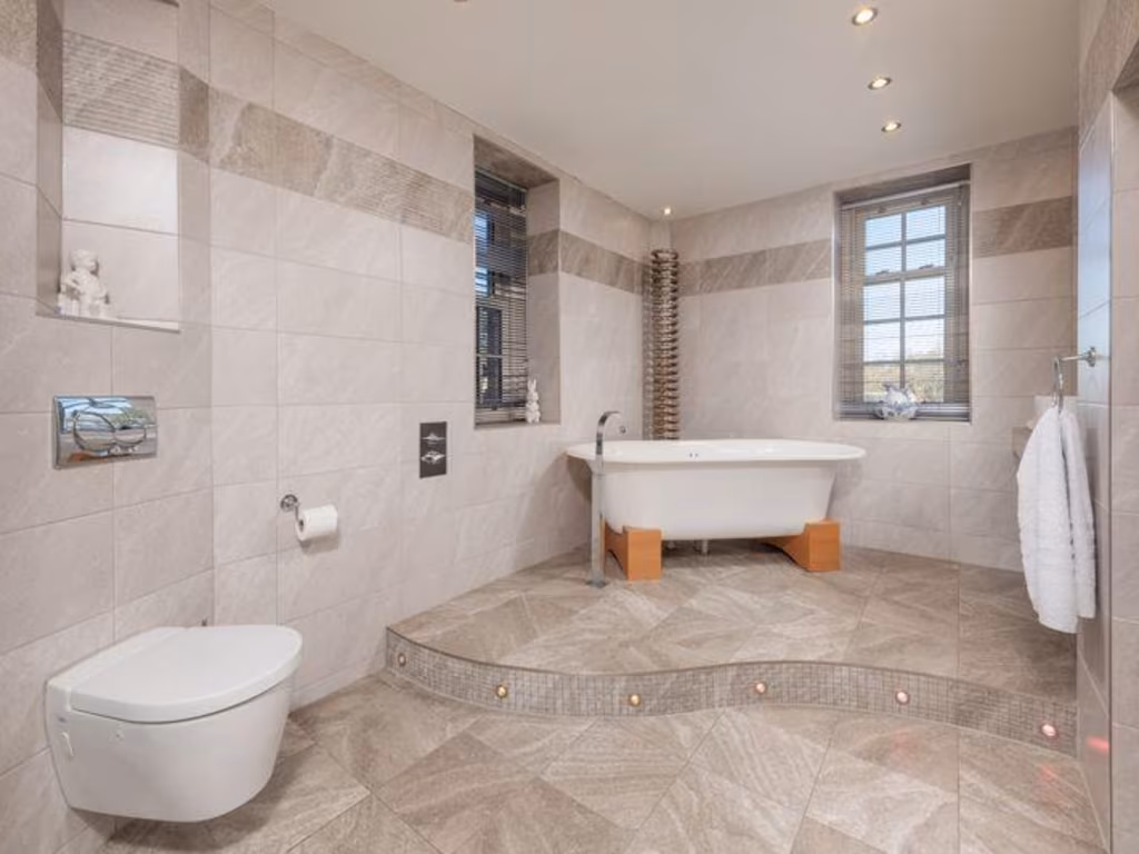
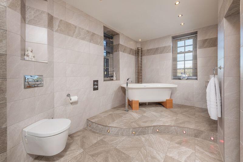
- Bathroom: Large
Textual Property Features
Detected Visual Features
- Georgian
- estate
- luxury
- historic
- mansion
- gardens
- country
- rural
- solar panels
- Victorian
- manor
- ivy-covered
- stone
- spacious garden
- landscaped grounds
- period features
- rural setting
Nearby Schools
- Tritlington Church of England First School
- Rothbury First School
- Dr Thomlinson Church of England Middle School
- Swarland Primary School
- Longhorsley St Helen's Church of England Aided First School
- Felton Church of England Primary School
Nearest General Shops
- Id: 4332332613
- Tags:
- Addr:
- City: Longframlington
- County: Northumberland
- Postcode: NE65 8DP
- Street: Front Street
- Fhrs:
- Name: R Green & Son
- Shop: butcher
- TagsNormalized:
- Lat: 55.3037955
- Lon: -1.7946504
- FullGeoHash: gcydx5tpvwew
- PartitionGeoHash: gcyd
- Images:
- FoodStandards:
- Id: 288379
- FHRSID: 288379
- LocalAuthorityBusinessID: 7427
- BusinessName: R Green & Son
- BusinessType: Retailers - other
- BusinessTypeID: 4613
- AddressLine1: Front Street
- AddressLine2: Longframlington
- AddressLine3: Northumberland
- AddressLine4: null
- PostCode: NE65 8DP
- RatingValue: 5
- RatingKey: fhrs_5_en-GB
- RatingDate: 2022-11-15
- LocalAuthorityCode: 707
- LocalAuthorityName: Northumberland
- LocalAuthorityWebSite: http://www.northumberland.gov.uk
- LocalAuthorityEmailAddress: public.protection@northumberland.gov.uk
- Scores:
- Hygiene: 5
- Structural: 5
- ConfidenceInManagement: 5
- NewRatingPending: false
- Geocode:
- Longitude: -1.79526700000000
- Latitude: 55.30397900000000
- Distance: 3326.9
,- Id: 4332332590
- Tags:
- Addr:
- City: Longframlington
- Housename: West Road Garage
- Postcode: NE65 8HX
- Name: Dennis Commom 4x4 Centre
- Phone: +44 1665 570542
- Shop: car
- Website: http://www.denniscommon.co.uk/
- TagsNormalized:
- Lat: 55.3020729
- Lon: -1.7986249
- FullGeoHash: gcydx56mcj84
- PartitionGeoHash: gcyd
- Images:
- FoodStandards: null
- Distance: 3195.6
,- Id: 6832152048
- Tags:
- Addr:
- City: Longframlington
- Place: High Weldon Farm
- Postcode: NE65 8AY
- Contact:
- Website: https://www.weldongunroom.co.uk/
- Name: Weldon Gun Room
- Shop: weapons
- TagsNormalized:
- Lat: 55.2862026
- Lon: -1.7752737
- FullGeoHash: gcydx8e33p5u
- PartitionGeoHash: gcyd
- Images:
- FoodStandards: null
- Distance: 1462.4
}
Nearest Religious buildings
- Id: 4284042366
- Tags:
- Amenity: place_of_worship
- Religion: christian
- TagsNormalized:
- place of worship
- christian
- church
- Lat: 55.2459401
- Lon: -1.7709989
- FullGeoHash: gcydr9nqutxt
- PartitionGeoHash: gcyd
- Images:
- FoodStandards: null
- Distance: 3286.8
,- Id: 363398924
- Tags:
- Amenity: place_of_worship
- Building: church
- Denomination: anglican
- Name: St. Mary the Virgin
- Religion: christian
- Source: OS_OpenData_StreetView
- Source:name: http://communities.northumberland.gov.uk/Longframlington.htm
- Wikidata: Q17527724
- TagsNormalized:
- place of worship
- church
- anglican
- christian
- Lat: 55.3029782
- Lon: -1.7953163
- FullGeoHash: gcydx5senn74
- PartitionGeoHash: gcyd
- Images:
- FoodStandards: null
- Distance: 3245.5
,- Id: 182187467
- Tags:
- Amenity: place_of_worship
- Building: church
- Denomination: anglican
- Name: Brinkburn Priory Church
- Religion: christian
- Wikidata: Q17527757
- TagsNormalized:
- place of worship
- church
- anglican
- christian
- Lat: 55.27891
- Lon: -1.819015
- FullGeoHash: gcydqx5qvzsn
- PartitionGeoHash: gcyd
- Images:
- FoodStandards: null
- Distance: 2195
}
Nearest Medical buildings
- Id: 179172091
- Tags:
- Amenity: hospital
- Building: hospital
- Designation: Community Hospital
- Emergency: no
- Name: Coquetdale Community Hospital
- Source: User
- TagsNormalized:
- Lat: 55.3068134
- Lon: -1.9138233
- FullGeoHash: gcydskq3s9mb
- PartitionGeoHash: gcyd
- Images:
- FoodStandards: null
- Distance: 8902.3
,- Id: 9167319184
- Tags:
- Amenity: dentist
- Healthcare: dentist
- Name: Rothbury Dental Practice
- TagsNormalized:
- dentist
- health
- healthcare
- dental
- Lat: 55.3068811
- Lon: -1.9137495
- FullGeoHash: gcydskq3ymuu
- PartitionGeoHash: gcyd
- Images:
- FoodStandards: null
- Distance: 8901.1
,- Id: 7937727643
- Tags:
- Amenity: doctors
- Healthcare: doctor
- Name: The Rothbury Practice
- TagsNormalized:
- doctor
- doctors
- health
- healthcare
- Lat: 55.3069426
- Lon: -1.913602
- FullGeoHash: gcydskqd3c6g
- PartitionGeoHash: gcyd
- Images:
- FoodStandards: null
- Distance: 8895.3
,- Id: 4333728055
- Tags:
- Addr:
- City: Felton
- Postcode: NE65 9PR
- Street: Main Street
- Amenity: doctors
- Name: Felton Surgery
- Phone: +44 1670 787353
- Website: https://www.feltonsurgery.nhs.uk/
- TagsNormalized:
- Lat: 55.2986628
- Lon: -1.7113269
- FullGeoHash: gcyf94cf51yh
- PartitionGeoHash: gcyf
- Images:
- FoodStandards: null
- Distance: 5407.9
}
Nearest Airports
- Id: 51496177
- Tags:
- Addr:
- City: Newcastle upon Tyne
- Housename: Newcastle International Airport
- Postcode: NE13 8BZ
- Street: Woolsington
- Aerodrome: international
- Aerodrome:type: public
- Aeroway: aerodrome
- Contact:
- Website: http://www.newcastleairport.com
- Ele: 81
- Iata: NCL
- Icao: EGNT
- Ifr: yes
- Name: Newcastle International Airport
- Old_name: Woolsington Aerodrome
- Operator: Newcastle International Airport Ltd
- Operator:type: private
- Phone: +44 871 882 1121
- Ref: NCL
- Size: 4500000
- Source: Bing
- Vfr: yes
- Website: https://www.newcastleairport.com/
- Wheelchair: yes
- Wikidata: Q8975
- Wikipedia: en:Newcastle International Airport
- TagsNormalized:
- airport
- international airport
- Lat: 55.0385826
- Lon: -1.6925163
- FullGeoHash: gcyc17rwcx2m
- PartitionGeoHash: gcyc
- Images:
- FoodStandards: null
- Distance: 26871.1
,- Id: 224091164
- Tags:
- Addr:
- City: Newcastle upon Tyne
- Postcode: NE13 8BZ
- Street: Woolsington
- Building: hotel
- Contact:
- Facebook: https://www.facebook.com/doubletree.newcastle
- Google_plus: https://plus.google.com/115643701064921491168/about
- Twitter: https://twitter.com/dtnewcastle_int
- Email: info@doubletree-newcastle.co.uk
- Fhrs:
- Name: DoubleTree by Hilton Hotel Newcastle International Airport
- Operator: Hilton Worldwide
- Phone: +44 1661 824266
- Rooms: 179
- Smoking: no
- Stars: 4
- Tourism: hotel
- Website: https://doubletree3.hilton.com/en/hotels/united-kingdom/doubletree-by-hilton-hotel-newcastle-international-airport-NCLNADI/index.html?WT.mc_id=zELWAKN0EMEA1DT2DMH3LocalSearch4DGGenericx6NCLNADI
- Wheelchair: yes
- TagsNormalized:
- hotel
- airport
- international airport
- tourism
- major airport
- Lat: 55.0364476
- Lon: -1.7124358
- FullGeoHash: gcyc1514937m
- PartitionGeoHash: gcyc
- Images:
- FoodStandards:
- Id: 236731
- FHRSID: 236731
- LocalAuthorityBusinessID: 11/00246/MIXED
- BusinessName: Doubletree By Hilton Hotel
- BusinessType: Hotel/bed & breakfast/guest house
- BusinessTypeID: 7842
- AddressLine1: Doubletree By Hilton Newcastle Airport
- AddressLine2: Woolsington
- AddressLine3: Newcastle Upon Tyne
- AddressLine4: null
- PostCode: NE13 8BZ
- RatingValue: 5
- RatingKey: fhrs_5_en-GB
- RatingDate: 2019-08-13
- LocalAuthorityCode: 416
- LocalAuthorityName: Newcastle Upon Tyne
- LocalAuthorityWebSite: http://www.newcastle.gov.uk/
- LocalAuthorityEmailAddress: psr@newcastle.gov.uk
- Scores:
- Hygiene: 0
- Structural: 5
- ConfidenceInManagement: 0
- NewRatingPending: false
- Geocode:
- Longitude: -1.71254240000000
- Latitude: 55.03664040000000
- Distance: 26855.9
}
Nearest Leisure Facilities
- Id: 651481773
- Tags:
- Leisure: pitch
- Sport: equestrian
- TagsNormalized:
- pitch
- leisure
- equestrian
- sports
- Lat: 55.2482931
- Lon: -1.7891049
- FullGeoHash: gcydr39hwu69
- PartitionGeoHash: gcyd
- Images:
- FoodStandards: null
- Distance: 2907.9
,- Id: 3618647
- Tags:
- Description: 18 hole Par 72
- Leisure: golf_course
- Name: Macdonald Linden Hall Golf & Country Club
- Phone: +44 844 879 9084
- Source: Bing
- Type: multipolygon
- Website: https://www.macdonaldhotels.co.uk/our-hotels/macdonald-linden-hall-golf-country-club/
- TagsNormalized:
- golf
- golf course
- leisure
- club
- Lat: 55.2619548
- Lon: -1.7605132
- FullGeoHash: gcydrunh1p40
- PartitionGeoHash: gcyd
- Images:
- FoodStandards: null
- Distance: 2089.5
,- Id: 673910173
- Tags:
- Leisure: pitch
- Sport: equestrian
- TagsNormalized:
- pitch
- leisure
- equestrian
- sports
- Lat: 55.2625326
- Lon: -1.7974436
- FullGeoHash: gcydrh5psd8z
- PartitionGeoHash: gcyd
- Images:
- FoodStandards: null
- Distance: 1523.2
,- Id: 651482010
- Tags:
- Leisure: pitch
- Source: Bing
- Sport: equestrian
- TagsNormalized:
- pitch
- leisure
- equestrian
- sports
- Lat: 55.2838446
- Lon: -1.7736898
- FullGeoHash: gcydx8h7wp94
- PartitionGeoHash: gcyd
- Images:
- FoodStandards: null
- Distance: 1286
,- Id: 435290872
- Tags:
- Leisure: pitch
- Sport: tennis
- TagsNormalized:
- Lat: 55.2806202
- Lon: -1.7859399
- FullGeoHash: gcydrre8bwd8
- PartitionGeoHash: gcyd
- Images:
- FoodStandards: null
- Distance: 697.9
}
Nearest Tourist attractions
- Id: 388119798
- Tags:
- Addr:
- Email: info@tindleshillcaravanpark.co.uk
- Name: Tindles Hill Caravan Park
- Name:en: Tindles Hill Caravan Park
- Opening_hours: 24/7
- Phone: +44 1670 788 217
- Source: Bing
- Tourism: caravan_site
- Website: http://tindleshillcaravanpark.co.uk
- TagsNormalized:
- Lat: 55.2679201
- Lon: -1.8291073
- FullGeoHash: gcydqmhnfxn9
- PartitionGeoHash: gcyd
- Images:
- FoodStandards: null
- Distance: 2866.1
,- Id: 873439387
- Tags:
- Source: Bing
- Tourism: caravan_site
- TagsNormalized:
- Lat: 55.2710804
- Lon: -1.8203227
- FullGeoHash: gcydqtf3rkjj
- PartitionGeoHash: gcyd
- Images:
- FoodStandards: null
- Distance: 2248.4
,- Id: 496704118
- Tags:
- Historic: heritage
- Name: Brinkburn Priory
- Operator: English Heritage
- Tourism: attraction
- Website: https://www.english-heritage.org.uk/visit/places/brinkburn-priory/
- Wikidata: Q4968406
- TagsNormalized:
- Lat: 55.2787902
- Lon: -1.8188805
- FullGeoHash: gcydqx5w3127
- PartitionGeoHash: gcyd
- Images:
- FoodStandards: null
- Distance: 2183.6
}
Nearest Train stations
- Id: 7556945771
- Tags:
- Name: Lionheart
- Public_transport: station
- Railway: station
- Usage: tourism
- Website: https://www.alnvalleyrailway.co.uk/
- Wikidata: Q60466730
- Wikipedia: en:Alnwick Lionheart railway station
- TagsNormalized:
- Lat: 55.4025681
- Lon: -1.6866887
- FullGeoHash: gcyg1tez371x
- PartitionGeoHash: gcyg
- Images:
- FoodStandards: null
- Distance: 15560.9
,- Id: 7209360087
- Tags:
- Name: Morpeth
- Naptan:
- Network: National Rail
- Public_transport: station
- Railway: station
- Ref:
- Wikidata: Q2534198
- Wikipedia: en:Morpeth railway station
- TagsNormalized:
- Lat: 55.1623623
- Lon: -1.6831484
- FullGeoHash: gcyccdn25c9s
- PartitionGeoHash: gcyc
- Images:
- FoodStandards: null
- Distance: 14037.7
,- Id: 6738885509
- Tags:
- Name: Pegswood
- Naptan:
- Network: National Rail
- Public_transport: station
- Railway: station
- Ref:
- Source: NPE
- Train: yes
- Wikidata: Q2495528
- Wikipedia: en:Pegswood railway station
- TagsNormalized:
- Lat: 55.1783232
- Lon: -1.6437205
- FullGeoHash: gcycfsgj48cn
- PartitionGeoHash: gcyc
- Images:
- FoodStandards: null
- Distance: 13951.2
,- Id: 46985645
- Tags:
- Name: Widdrington
- Naptan:
- Network: National Rail
- Public_transport: station
- Railway: station
- Ref:
- Source: NPE
- Wheelchair: yes
- Wikidata: Q2572775
- Wikipedia: en:Widdrington railway station
- TagsNormalized:
- Lat: 55.2411444
- Lon: -1.6162192
- FullGeoHash: gcyf70r4gret
- PartitionGeoHash: gcyf
- Images:
- FoodStandards: null
- Distance: 11332.6
,- Id: 5520053927
- Tags:
- Name: Acklington
- Naptan:
- Network: National Rail
- Operator: Northern
- Public_transport: station
- Railway: station
- Ref:
- Source: NPE
- Wikidata: Q3517520
- Wikipedia: en:Acklington railway station
- TagsNormalized:
- Lat: 55.3072171
- Lon: -1.6517687
- FullGeoHash: gcyfdkm5yuxb
- PartitionGeoHash: gcyf
- Images:
- FoodStandards: null
- Distance: 9210.3
}
Nearest Bus stations and stops
- Id: 8071359252
- Tags:
- Bench: yes
- Bus: yes
- Highway: bus_stop
- Public_transport: platform
- Shelter: yes
- TagsNormalized:
- Lat: 55.3140776
- Lon: -1.7207496
- FullGeoHash: gcyf8vdgzekj
- PartitionGeoHash: gcyf
- Images:
- FoodStandards: null
- Distance: 6017.4
,- Id: 4151175487
- Tags:
- Bench: yes
- Bus: yes
- Departures_board: timetable
- Highway: bus_stop
- Name: Felton, Davison Avenue
- Public_transport: platform
- Shelter: yes
- TagsNormalized:
- Lat: 55.3020902
- Lon: -1.7123355
- FullGeoHash: gcyf953n58y1
- PartitionGeoHash: gcyf
- Images:
- FoodStandards: null
- Distance: 5554.7
,- Id: 8071359255
- Tags:
- Bench: yes
- Bin: yes
- Bus: yes
- Departures_board: timetable
- Highway: bus_stop
- Name: Felton, Davison Avenue
- Public_transport: platform
- Shelter: yes
- TagsNormalized:
- Lat: 55.3011227
- Lon: -1.7118058
- FullGeoHash: gcyf95382h3n
- PartitionGeoHash: gcyf
- Images:
- FoodStandards: null
- Distance: 5524
,- Id: 1596266479
- Tags:
- Bus: yes
- Highway: bus_stop
- Public_transport: platform
- Shelter: yes
- TagsNormalized:
- Lat: 55.2609756
- Lon: -1.7081401
- FullGeoHash: gcyf35unt2qr
- PartitionGeoHash: gcyf
- Images:
- FoodStandards: null
- Distance: 5109.4
,- Id: 7835867541
- Tags:
- Bus: yes
- Highway: bus_stop
- Public_transport: platform
- Shelter: yes
- TagsNormalized:
- Lat: 55.2929065
- Lon: -1.7135312
- FullGeoHash: gcyf91b0xbfd
- PartitionGeoHash: gcyf
- Images:
- FoodStandards: null
- Distance: 4990.9
}
Nearest Hotels
- Id: 429078597
- Tags:
- Addr:
- City: Rothbury
- County: Northumberland
- Postcode: NE65 7QH
- Street: Station Road
- Building: yes
- Fhrs:
- Name: The Coquetvale Hotel
- Phone: +44 1669 622900
- Tourism: hotel
- Website: https://www.coquetvale.co.uk/
- TagsNormalized:
- Lat: 55.3082459
- Lon: -1.9051174
- FullGeoHash: gcydsss9zs39
- PartitionGeoHash: gcyd
- Images:
- FoodStandards: null
- Distance: 8470.9
,- Id: 207219267
- Tags:
- Addr:
- City: Eshott
- County: Northumberland
- Postcode: NE65 9EN
- Street: Stable Drive
- Building: yes
- Fhrs:
- Name: Eshott Hall
- Phone: +44 1670 787454
- Source: Bing
- Tourism: hotel
- Website: https://www.eshotthall.co.uk/
- TagsNormalized:
- Lat: 55.2737839
- Lon: -1.6828158
- FullGeoHash: gcyf3wq95s1s
- PartitionGeoHash: gcyf
- Images:
- FoodStandards: null
- Distance: 6491.6
,- Id: 239911242
- Tags:
- Addr:
- City: Longframlington
- Postcode: NE65 8DT
- Landuse: commercial
- Name: Embleton Hall Hotel
- Phone: +44 1665 570249
- Tourism: hotel
- Wikidata: Q5370093
- Wikipedia: en:Embleton Hall
- TagsNormalized:
- Lat: 55.3061238
- Lon: -1.7961665
- FullGeoHash: gcydxhhjd29p
- PartitionGeoHash: gcyd
- Images:
- FoodStandards: null
- Distance: 3599
}
Tags
- Georgian
- estate
- luxury
- historic
- mansion
- gardens
- country
- rural
- solar panels
- Victorian
- manor
- ivy-covered
- stone
- historic
- spacious garden
- landscaped grounds
- period features
- rural setting
Local Market Stats
- Average Price/sqft: £219
- Avg Income: £40500
- Social Housing: 5%
- Planning Success Rate: 84%
Similar Properties
 5 bedroom detached house for sale in Toft Hall, Kirkheaton, Northumberland, NE19 — £1,600,000 • 5 bed • 6 bath • 5255 ft²
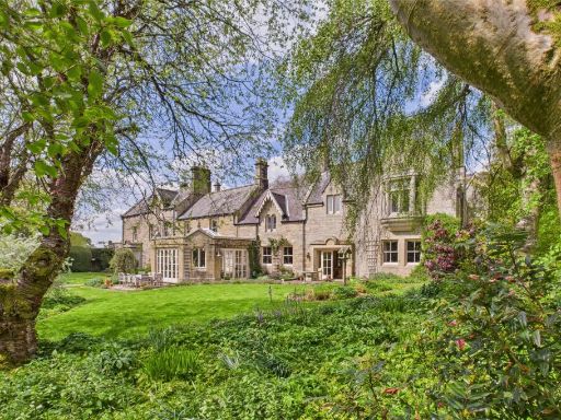 7 bedroom manor house for sale in Wreighburn House, Thropton, Morpeth, Northumberland, NE65 — £2,600,000 • 7 bed • 7 bath • 7200 ft²
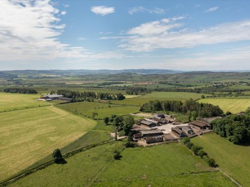 4 bedroom farm house for sale in Eglingham, Alnwick, Northumberland, NE66 — £9,500,000 • 4 bed • 1 bath • 2820 ft²
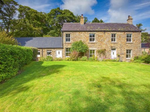 4 bedroom detached house for sale in Minsteracres, Consett, DH8 — £995,000 • 4 bed • 3 bath • 3021 ft²
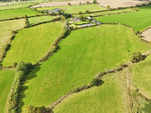 Equestrian facility for sale in Longframlington, Morpeth, NE65 — £1,950,000 • 4 bed • 1 bath • 2852 ft²
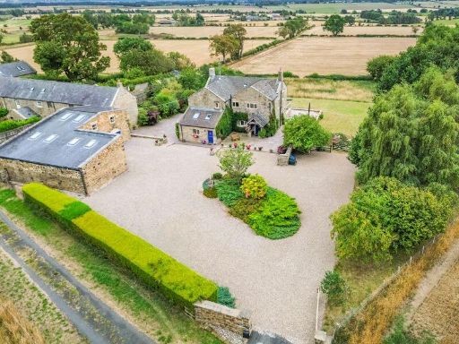 4 bedroom detached house for sale in North Low House, Whalton, Morpeth, Northumberland, NE61 — £1,150,000 • 4 bed • 4 bath • 2761 ft²
Meta
- {
"@context": "https://schema.org",
"@type": "Residence",
"name": "7 bedroom country house for sale in Ghyllheugh Estate, Long…",
"description": "",
"url": "https://propertypiper.co.uk/property/23734d77-825f-4945-bb77-e3e1da8cd975",
"image": "https://image-a.propertypiper.co.uk/9fd7470b-71e6-4ca6-8878-4131e7313348-1024.jpeg",
"address": {
"@type": "PostalAddress",
"streetAddress": "GHYLLHEUGH LODGE LONGHORSLEY MORPETH",
"postalCode": "NE65 8RF",
"addressLocality": "Northumberland",
"addressRegion": "Berwick-upon-Tweed",
"addressCountry": "England"
},
"geo": {
"@type": "GeoCoordinates",
"latitude": 55.27435433783528,
"longitude": -1.7852959598423053
},
"numberOfRooms": 7,
"numberOfBathroomsTotal": 6,
"floorSize": {
"@type": "QuantitativeValue",
"value": 8088,
"unitCode": "FTK"
},
"offers": {
"@type": "Offer",
"price": 7500000,
"priceCurrency": "GBP",
"availability": "https://schema.org/InStock"
},
"additionalProperty": [
{
"@type": "PropertyValue",
"name": "Feature",
"value": "Georgian"
},
{
"@type": "PropertyValue",
"name": "Feature",
"value": "estate"
},
{
"@type": "PropertyValue",
"name": "Feature",
"value": "luxury"
},
{
"@type": "PropertyValue",
"name": "Feature",
"value": "historic"
},
{
"@type": "PropertyValue",
"name": "Feature",
"value": "mansion"
},
{
"@type": "PropertyValue",
"name": "Feature",
"value": "gardens"
},
{
"@type": "PropertyValue",
"name": "Feature",
"value": "country"
},
{
"@type": "PropertyValue",
"name": "Feature",
"value": "rural"
},
{
"@type": "PropertyValue",
"name": "Feature",
"value": "solar panels"
},
{
"@type": "PropertyValue",
"name": "Feature",
"value": "Victorian"
},
{
"@type": "PropertyValue",
"name": "Feature",
"value": "manor"
},
{
"@type": "PropertyValue",
"name": "Feature",
"value": "ivy-covered"
},
{
"@type": "PropertyValue",
"name": "Feature",
"value": "stone"
},
{
"@type": "PropertyValue",
"name": "Feature",
"value": "historic"
},
{
"@type": "PropertyValue",
"name": "Feature",
"value": "spacious garden"
},
{
"@type": "PropertyValue",
"name": "Feature",
"value": "landscaped grounds"
},
{
"@type": "PropertyValue",
"name": "Feature",
"value": "period features"
},
{
"@type": "PropertyValue",
"name": "Feature",
"value": "rural setting"
}
]
}
High Res Floorplan Images
Compatible Floorplan Images
FloorplanImages Thumbnail