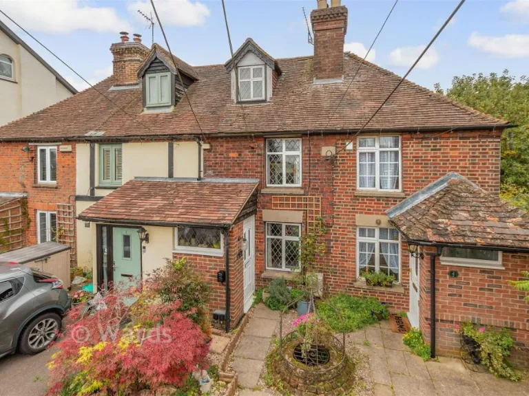
TN15 6JN - 2 bedroom terraced house for sale in School Lane, West King…
View on Property Piper
2 bedroom terraced house for sale in School Lane, West Kingsdown, Kent, TN15
Property Details
- Price: £271000
- Bedrooms: 2
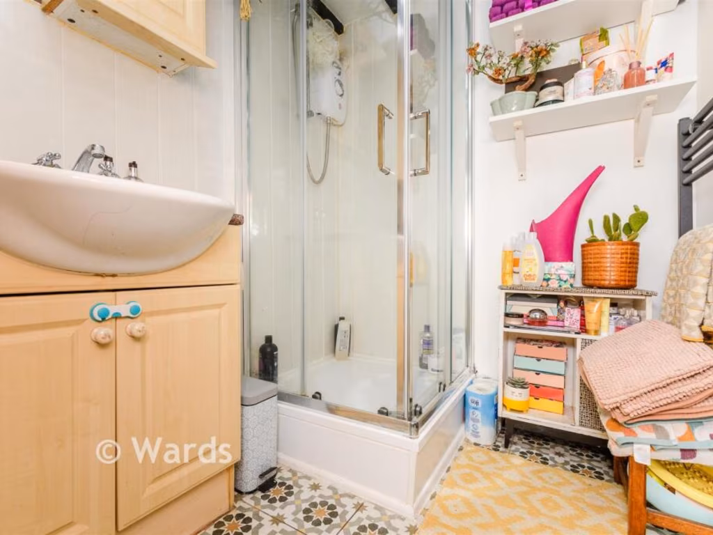
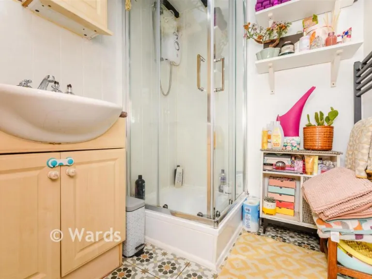
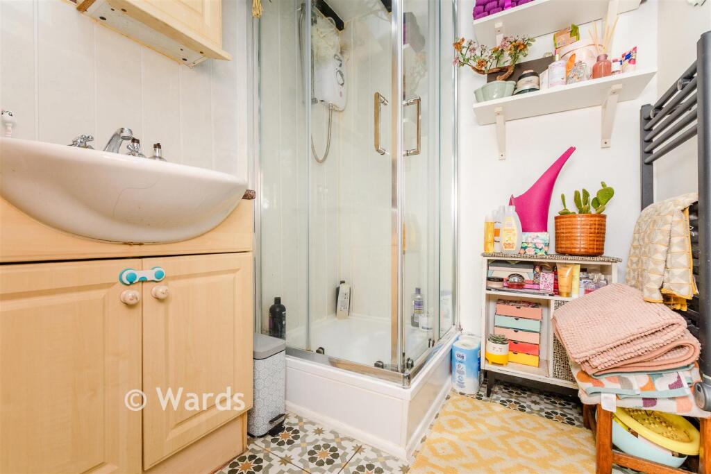
- Bathrooms: 1
- Property Type: undefined
- Property SubType: undefined
Image Descriptions
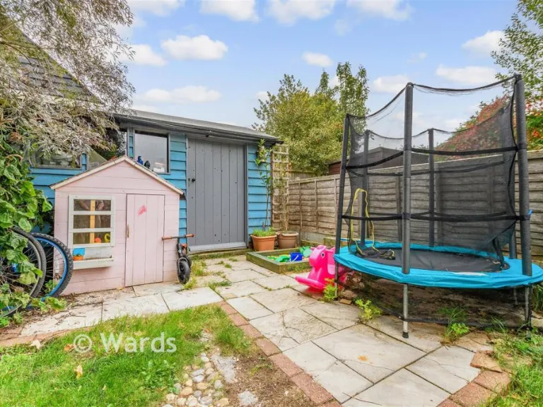
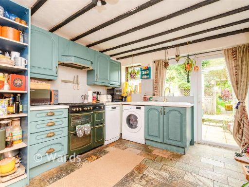
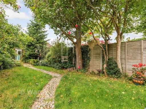
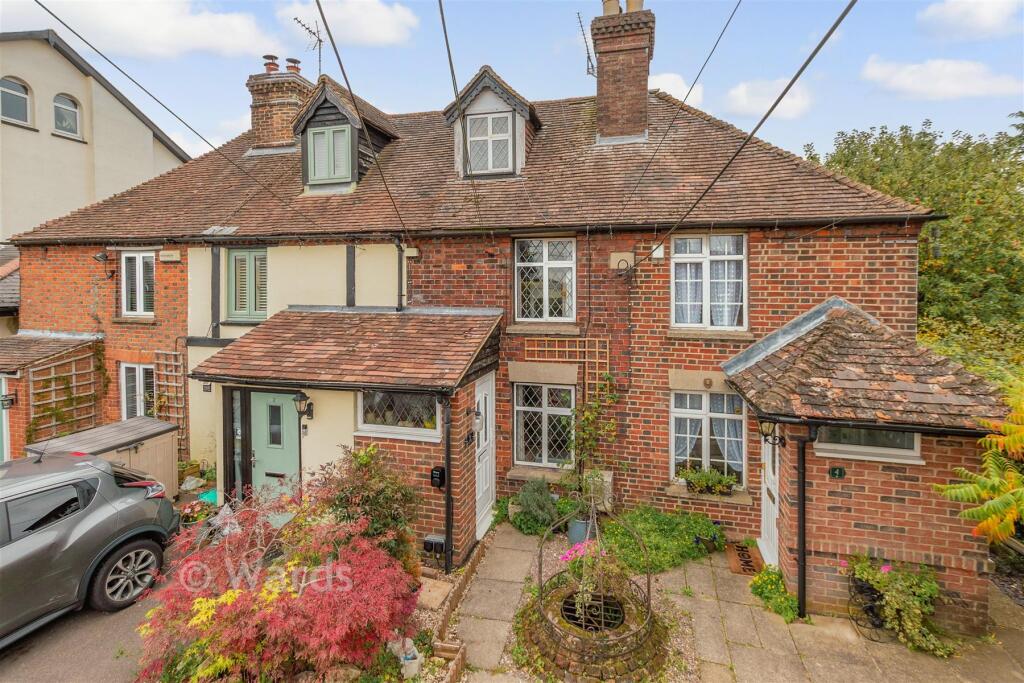
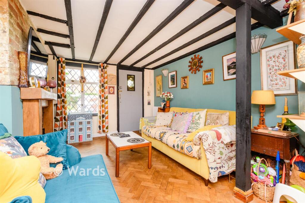
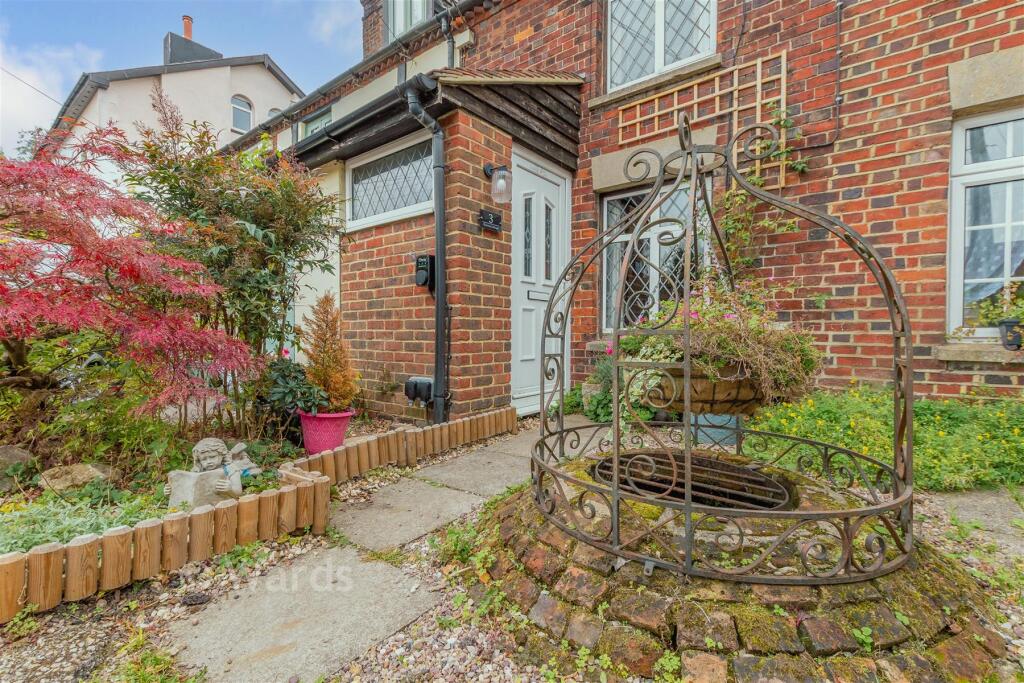
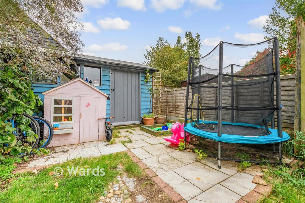
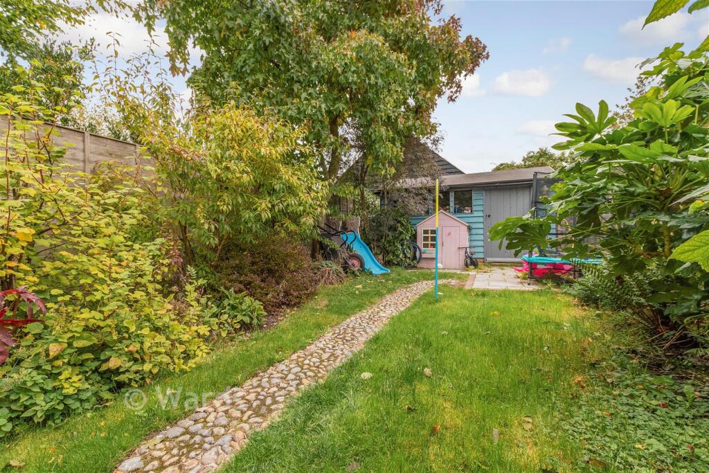
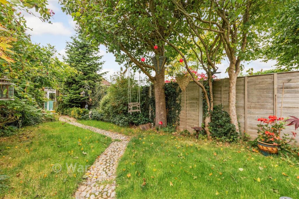
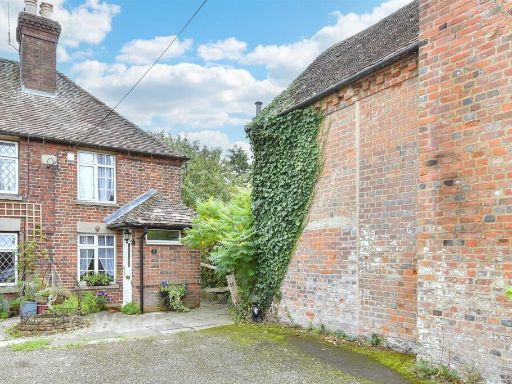
- a terraced house Victorian
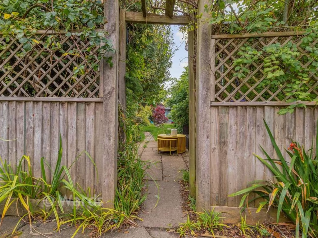
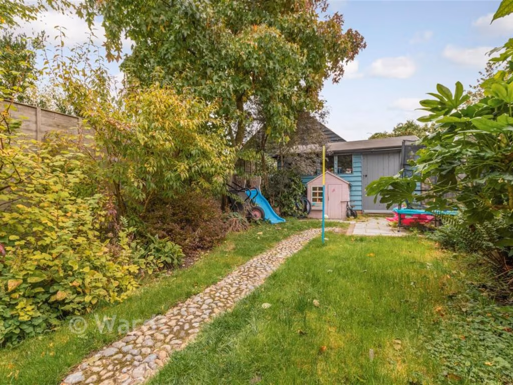
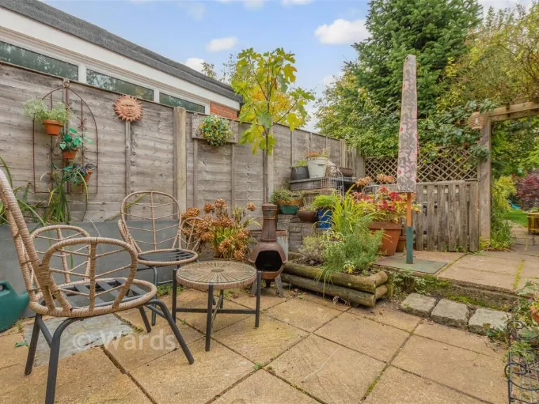
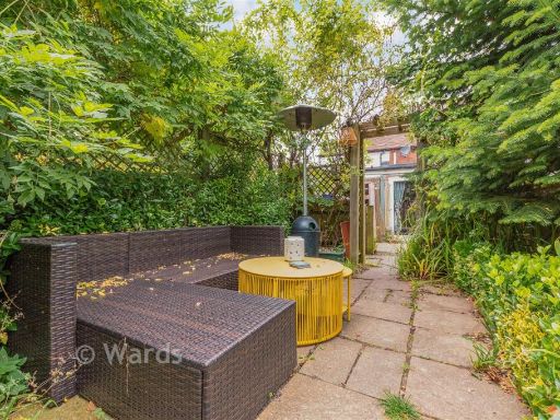
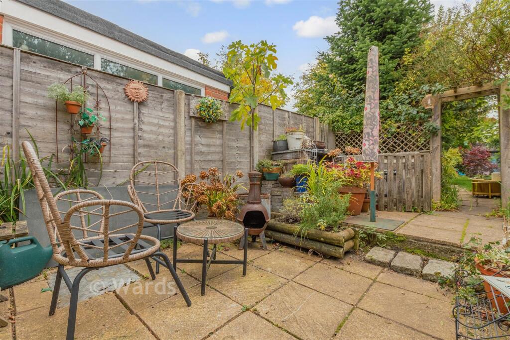
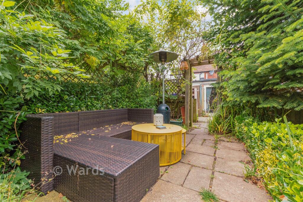
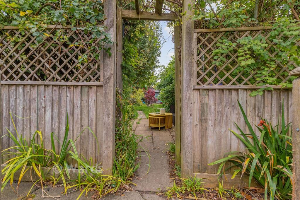
- garden contemporary
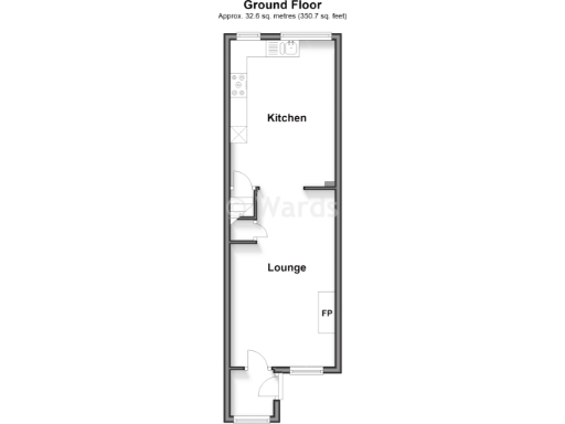
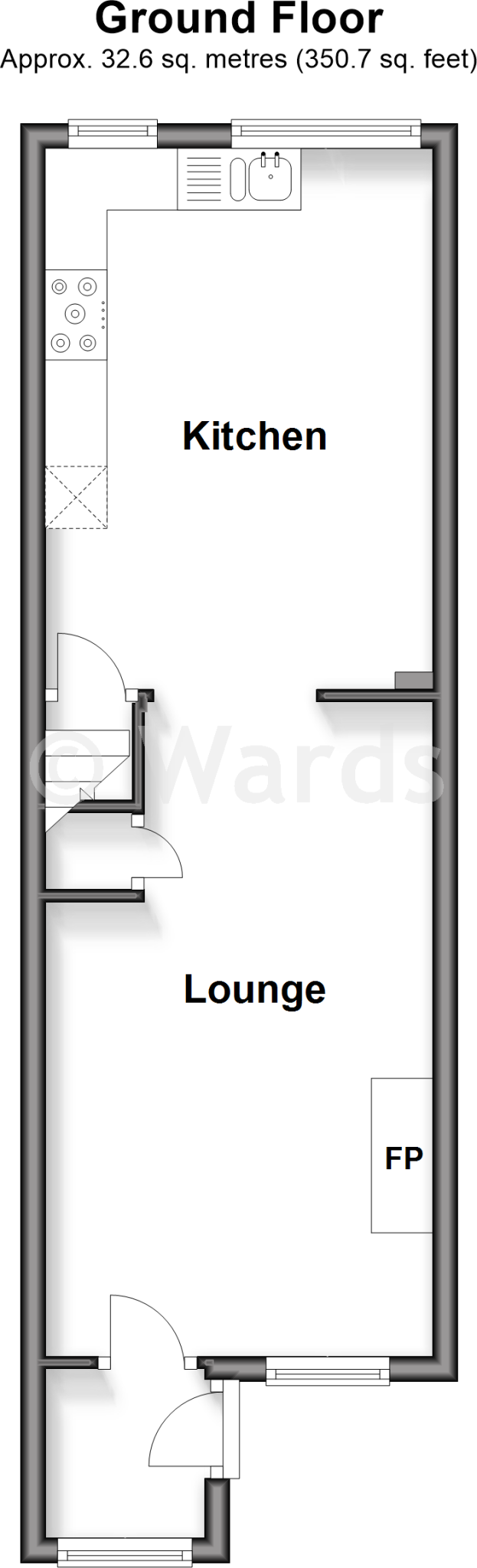
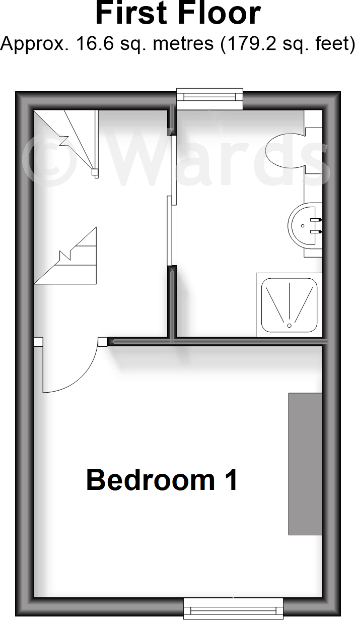
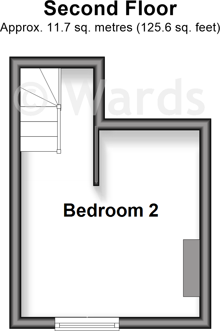
Floorplan Description
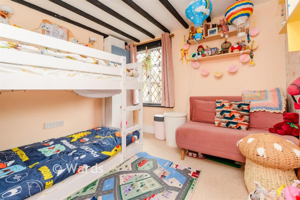
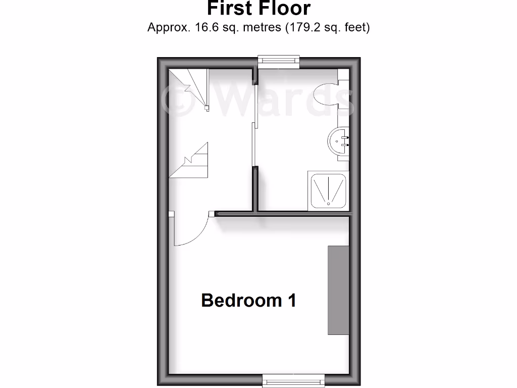
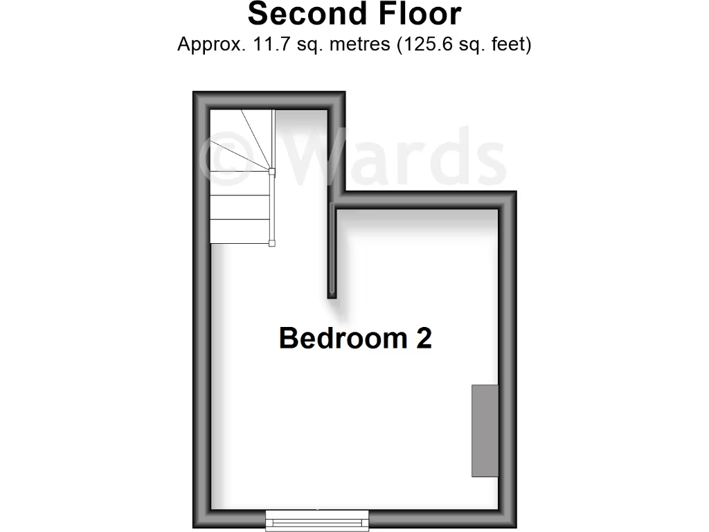
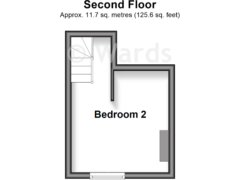
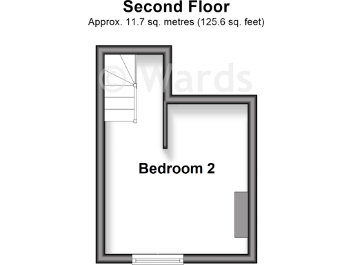
- Room labelled 'Bedroom 2' shown on plan
Rooms
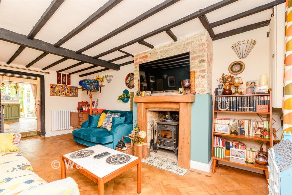
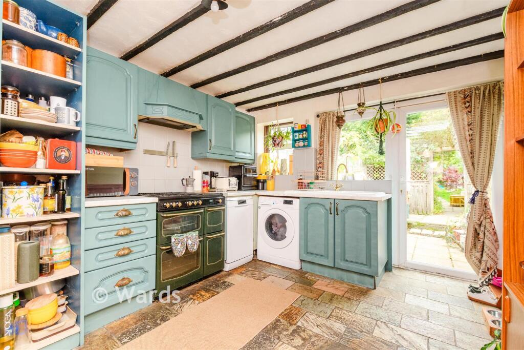
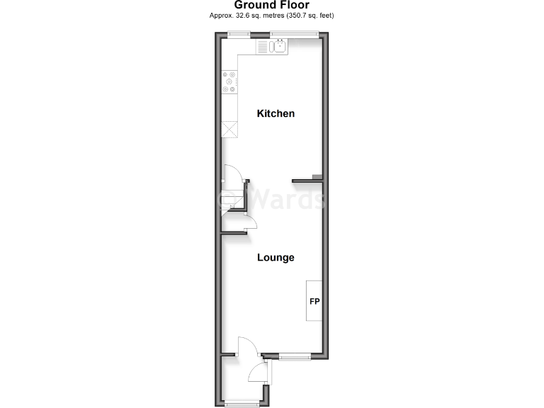
- Kitchen:
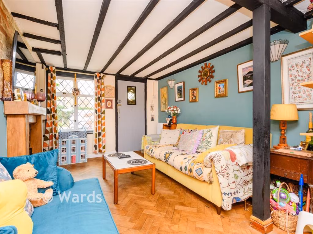
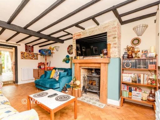
- Lounge:
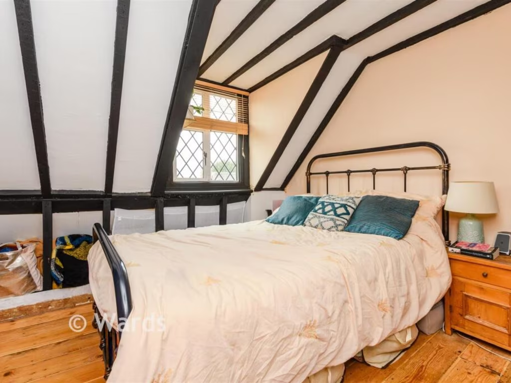
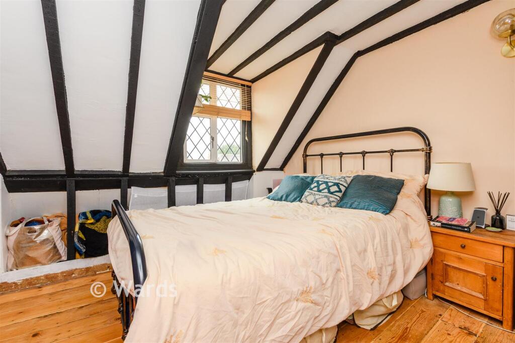
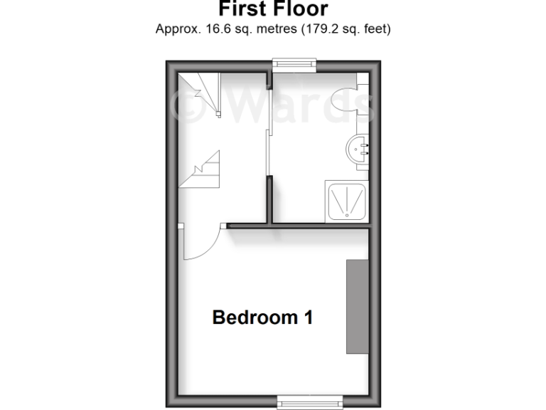
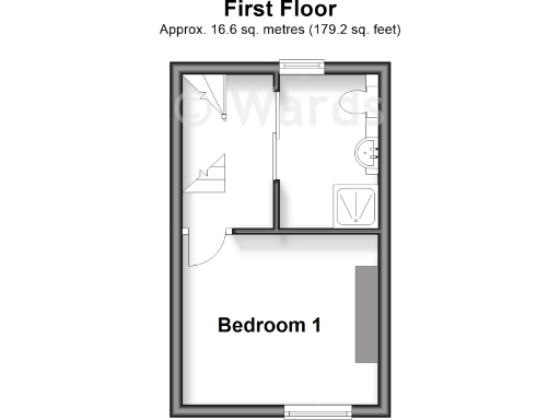
- Bedroom 1:
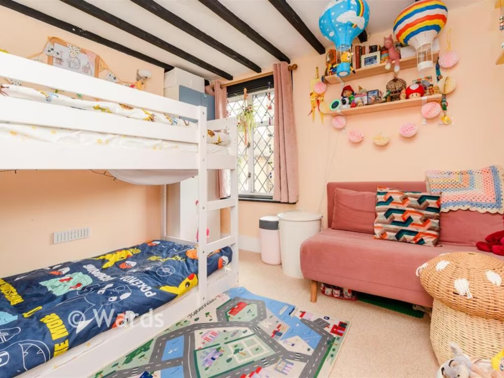
- Bedroom 2:
Textual Property Features
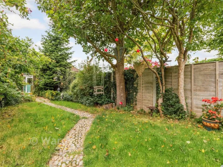
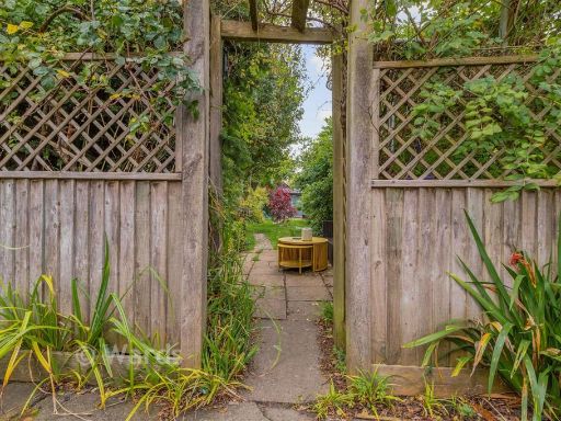
- Has Garden
- Is Retirement
- Success
Detected Visual Features
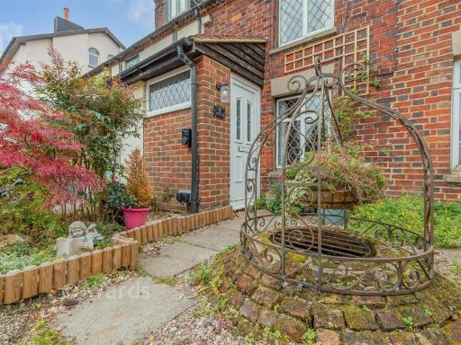
- Victorian
- terraced house
- brick exterior
- chimney
- small garden
- period property
- roof tiles
- two-story
- front porch
- traditional windows
- garden
- patio
- contemporary
- outdoor space
- fencing
- privacy
- low maintenance
- landscaping
- paved
- urban
- seating area
EPC Details
- Fully double glazed
- Solid brick, as built, no insulation (assumed)
- Room heaters, electric
- Low energy lighting in 50% of fixed outlets
- Solid, no insulation (assumed)
Nearby Schools
- Wrotham School
- Kemsing Primary School
- Otford Primary School
- St Michael's Prep School
- Shoreham Village School
- Culverstone Green Primary School
- Fawkham Church of England Voluntary Controlled Primary School
- Longfield Academy
- St John's Church of England Primary School, Sevenoaks
- Russell House School
- Hartley Primary Academy
- Our Lady of Hartley Catholic Primary School, Hartley, Longfield
- Steephill School
- Sevenoaks Preparatory School
- St Lawrence Church of England Primary School
- Ightham Primary School
- Trinity School
- Platt Church of England Voluntary Aided Primary School
- St George's Church of England Voluntary Controlled Primary School
- New Ash Green Primary School
- The Anthony Roper Primary School
- Horton Kirby Church of England Primary School
- Seal Church of England Voluntary Controlled Primary School
- Borough Green Primary School
- St. Edmund's Church of England Primary School
- Langafel Church of England Voluntary Controlled Primary School
Nearest General Shops
- Id: 8951108540
- Tags:
- Addr:
- City: West Kingsdown
- Housename: Portobello Parade
- Housenumber: 5
- Postcode: TN15 6JP
- Street: Fawkham Road
- Name: The Pet Groomers
- Opening_hours: Tu-Th 08:30-17:30; Fr-Sa 08:30-17:00
- Phone: +44 1474 854 464
- Shop: pet_grooming
- Website: http://www.thepetgroomers.uk/
- TagsNormalized:
- Lat: 51.341668
- Lon: 0.2675002
- FullGeoHash: u10hn46ychwe
- PartitionGeoHash: u10h
- Images:
- FoodStandards: null
- Distance: 558.8
,- Id: 8951108541
- Tags:
- Addr:
- City: West Kingsdown
- Housename: Portobello Parade
- Housenumber: 4
- Postcode: TN15 6JP
- Street: Fawkham Road
- Email: oceania@btconnect.com
- Name: Oceania Health & Beauty
- Opening_hours: Tu 10:00-18:00; We 10:00-17:00; Th 10:00-20:00; Fr 10:00-17:00; Sa 10:00-14:00
- Phone: +44 1474 850627
- Shop: beauty
- Website: https://www.oceaniahealthandbeauty.co.uk/
- TagsNormalized:
- Lat: 51.3416128
- Lon: 0.267516
- FullGeoHash: u10hn46y9d63
- PartitionGeoHash: u10h
- Images:
- FoodStandards: null
- Distance: 552.9
,- Id: 8951108543
- Tags:
- Addr:
- City: West Kingsdown
- Housename: Portobello Parade
- Housenumber: 2
- Postcode: TN15 6JP
- Street: Fawkham Road
- Name: Betsy's Hair Salon
- Opening_hours: Mo-Tu 10:00-18:00; We 10:00-20:00; Th-Fr 10:00-18:00; Sa 09:00-19:00
- Phone: +44 1474 853436
- Shop: hairdresser
- TagsNormalized:
- Lat: 51.3415272
- Lon: 0.26747
- FullGeoHash: u10hn46y0d25
- PartitionGeoHash: u10h
- Images:
- FoodStandards: null
- Distance: 543
}
Nearest Grocery shops
- Id: 8865868883
- Tags:
- Addr:
- City: West Kingsdown
- Postcode: TN15 6HD
- Street: Hever Road
- Brand: McColl's
- Brand:wikidata: Q16997477
- Brand:wikipedia: en:McColl's
- Contact:
- Website: https://www.mccolls.co.uk/storelocator/west-kingsdown-28-hever-road/
- Name: McColl's
- Shop: convenience
- TagsNormalized:
- Lat: 51.3506096
- Lon: 0.2564165
- FullGeoHash: u10hju4dyzqj
- PartitionGeoHash: u10h
- Images:
- FoodStandards: null
- Distance: 1679.1
,- Id: 8865868884
- Tags:
- Addr:
- City: West Kingsdown
- Postcode: TN15 6HD
- Street: Hever Road
- Brand: Co-op Food
- Brand:wikidata: Q3277439
- Brand:wikipedia: en:Co-op Food
- Name: Co-op Food
- Opening_hours: Mo-Su 07:00-22:00
- Operator: The Co-operative Group
- Operator:wikidata: Q117202
- Shop: convenience
- TagsNormalized:
- co-op
- co-op food
- food
- convenience
- shop
- Lat: 51.3506166
- Lon: 0.2566198
- FullGeoHash: u10hju4g58tx
- PartitionGeoHash: u10h
- Images:
- FoodStandards: null
- Distance: 1674.3
,- Id: 8951108544
- Tags:
- Addr:
- City: West Kingsdown
- Housename: Portobello Parade
- Housenumber: 1
- Postcode: TN15 6JP
- Street: Fawkham Road
- Name: West Kingsdown Mini Market
- Phone: +44 1474 850887
- Shop: convenience
- TagsNormalized:
- Lat: 51.3414781
- Lon: 0.2674436
- FullGeoHash: u10hn46tzchq
- PartitionGeoHash: u10h
- Images:
- FoodStandards: null
- Distance: 537.3
}
Nearest Supermarkets
- Id: 1810142316
- Tags:
- Addr:
- Brand:
- Check_date:
- Opening_hours: 2022-01-31
- Contact:
- Website: https://stores.sainsburys.co.uk/0063/sevenoaks
- Name: Sainsbury's
- Opening_hours: Mo-Fr 06:30-22:30; Sa 06:30-22:00; Su 10:00-16:00
- Shop: supermarket
- TagsNormalized:
- sainsburys
- supermarket
- shop
- Lat: 51.2963334
- Lon: 0.1930336
- FullGeoHash: u105u6hwf187
- PartitionGeoHash: u105
- Images:
- FoodStandards: null
- Distance: 6772.8
,- Id: 579991347
- Tags:
- Addr:
- Brand: Co-op Food
- Brand:wikidata: Q3277439
- Brand:wikipedia: en:Co-op Food
- Name: Co-op Food
- Shop: supermarket
- TagsNormalized:
- co-op
- co-op food
- food
- supermarket
- shop
- Lat: 51.2933613
- Lon: 0.3067601
- FullGeoHash: u105ycxmkp8f
- PartitionGeoHash: u105
- Images:
- FoodStandards: null
- Distance: 5594.8
,- Id: 727348503
- Tags:
- Addr:
- Housenumber: 30
- Postcode: DA3 8JB
- Street: The Row
- Brand: Co-op Food
- Brand:wikidata: Q3277439
- Brand:wikipedia: en:Co-op Food
- Fhrs:
- Name: Co-op Food
- Shop: supermarket
- TagsNormalized:
- co-op
- co-op food
- food
- supermarket
- shop
- Lat: 51.3659358
- Lon: 0.3050945
- FullGeoHash: u10hnyyhm0qy
- PartitionGeoHash: u10h
- Images:
- FoodStandards:
- Id: 266811
- FHRSID: 266811
- LocalAuthorityBusinessID: 08/00008/MIXED
- BusinessName: The Co-operative
- BusinessType: Retailers - supermarkets/hypermarkets
- BusinessTypeID: 7840
- AddressLine1: 22 The Row
- AddressLine2: New Ash Green
- AddressLine3: KENT
- AddressLine4: null
- PostCode: DA3 8JB
- RatingValue: 5
- RatingKey: fhrs_5_en-GB
- RatingDate: 2022-03-08
- LocalAuthorityCode: 187
- LocalAuthorityName: Sevenoaks
- LocalAuthorityWebSite: http://www.sevenoaks.gov.uk/
- LocalAuthorityEmailAddress: environmental.health@sevenoaks.gov.uk
- Scores:
- Hygiene: 5
- Structural: 5
- ConfidenceInManagement: 5
- NewRatingPending: false
- Geocode:
- Longitude: 0.30493440000000
- Latitude: 51.36581910000000
- Distance: 4234.2
}
Nearest Religious buildings
- Id: 282162211
- Tags:
- Addr:
- Amenity: place_of_worship
- Building: church
- Denomination: anglican
- Name: St Edmund King and Martyr
- Religion: christian
- Source: OS_OpenData_StreetView
- Wikidata: Q17529896
- TagsNormalized:
- place of worship
- church
- anglican
- christian
- Lat: 51.3473293
- Lon: 0.2672466
- FullGeoHash: u10hn56xg7cw
- PartitionGeoHash: u10h
- Images:
- FoodStandards: null
- Distance: 1181.3
,- Id: 967534383
- Tags:
- Amenity: place_of_worship
- Building: yes
- Denomination: roman_catholic
- Name: Catholic Church of St Bernadette
- Religion: christian
- Source: OS_OpenData_StreetView
- TagsNormalized:
- place of worship
- catholic
- roman catholic
- church
- christian
- Lat: 51.3424869
- Lon: 0.2682741
- FullGeoHash: u10hn4e7ejr8
- PartitionGeoHash: u10h
- Images:
- FoodStandards: null
- Distance: 659.4
,- Id: 967534382
- Tags:
- Amenity: place_of_worship
- Building: yes
- Denomination: baptist
- Name: West Kingsdown Baptist Church
- Religion: christian
- TagsNormalized:
- place of worship
- baptist
- church
- christian
- Lat: 51.3412457
- Lon: 0.2675458
- FullGeoHash: u10hn46u6mbs
- PartitionGeoHash: u10h
- Images:
- FoodStandards: null
- Distance: 513.4
}
Nearest Airports
- Id: 121158889
- Tags:
- Aerodrome: continental
- Aeroway: aerodrome
- Fhrs:
- Authority: City of London Corporation
- Iata: LCY
- Icao: EGLC
- Name: London City Airport
- Operator: London City Airport Limited
- Ref: LCY
- Website: https://www.londoncityairport.com/
- Wikidata: Q8982
- Wikipedia: en:London City Airport
- TagsNormalized:
- airport
- continental airport
- Lat: 51.5042658
- Lon: 0.0539987
- FullGeoHash: u10j10p64702
- PartitionGeoHash: u10j
- Images:
- FoodStandards: null
- Distance: 23728.5
,- Id: 103894219
- Tags:
- Aerodrome: international
- Aeroway: aerodrome
- Iata: SEN
- Icao: EGMC
- Name: London Southend Airport
- Old_name: Southend Municipal Airport
- Ref: SEN
- Wikidata: Q1415441
- TagsNormalized:
- airport
- international airport
- Lat: 51.5701749
- Lon: 0.6924624
- FullGeoHash: u10mru04p937
- PartitionGeoHash: u10m
- Images:
- FoodStandards: null
- Distance: 39333.7
,- Id: 260720166
- Tags:
- Aerodrome: international
- Aeroway: aerodrome
- Alt_name: Gatwick Airport
- Ele: 62
- Iata: LGW
- Icao: EGKK
- Internet_access: wlan
- Internet_access:fee: no
- Internet_access:ssid: Gatwick FREE Wi-Fi
- Name: London Gatwick Airport
- Operator: Gatwick Airport Limited
- Ref: LGW
- Website: https://www.gatwickairport.com/
- Wikidata: Q8703
- Wikipedia: en:Gatwick Airport
- TagsNormalized:
- airport
- international airport
- Lat: 51.1540917
- Lon: -0.1883773
- FullGeoHash: gcpg58qf4mzd
- PartitionGeoHash: gcpg
- Images:
- FoodStandards: null
- Distance: 37584.3
}
Nearest Leisure Facilities
- Id: 965744514
- Tags:
- TagsNormalized:
- Lat: 51.3365682
- Lon: 0.264368
- FullGeoHash: u10hn1890jzj
- PartitionGeoHash: u10h
- Images:
- FoodStandards: null
- Distance: 112.2
,- Id: 965744516
- Tags:
- TagsNormalized:
- Lat: 51.3362498
- Lon: 0.2645887
- FullGeoHash: u10hn12xm6ed
- PartitionGeoHash: u10h
- Images:
- FoodStandards: null
- Distance: 109.6
,- Id: 965744515
- Tags:
- TagsNormalized:
- Lat: 51.3365313
- Lon: 0.2644896
- FullGeoHash: u10hn188gp19
- PartitionGeoHash: u10h
- Images:
- FoodStandards: null
- Distance: 104.7
,- Id: 965744517
- Tags:
- TagsNormalized:
- Lat: 51.3362731
- Lon: 0.2649787
- FullGeoHash: u10hn12zqqym
- PartitionGeoHash: u10h
- Images:
- FoodStandards: null
- Distance: 85.4
,- Id: 965744527
- Tags:
- TagsNormalized:
- Lat: 51.3361578
- Lon: 0.2652817
- FullGeoHash: u10hn13nv92m
- PartitionGeoHash: u10h
- Images:
- FoodStandards: null
- Distance: 79.7
}
Nearest Tourist attractions
- Id: 970603200
- Tags:
- Email: salesclearways@aol.com
- Name: Clearways Park
- Phone: +44 1474852520
- Tourism: caravan_site
- Website: www.clearwayspark.co.uk
- TagsNormalized:
- Lat: 51.347112
- Lon: 0.2527587
- FullGeoHash: u10hjg2n9eqt
- PartitionGeoHash: u10h
- Images:
- FoodStandards: null
- Distance: 1473.8
,- Id: 3067333452
- Tags:
- Addr:
- Postcode: TN15 7EG
- Street: Ash Lane
- Name: Kent Firefighting Museum
- Tourism: museum
- Website: http://www.kentfirefightingmuseum.org.uk
- TagsNormalized:
- Lat: 51.331424
- Lon: 0.2849721
- FullGeoHash: u10hn2xe0qfx
- PartitionGeoHash: u10h
- Images:
- FoodStandards: null
- Distance: 1446.8
,- Id: 968859088
- Tags:
- Name: Kaysland Park
- Tourism: caravan_site
- TagsNormalized:
- Lat: 51.3447376
- Lon: 0.2550373
- FullGeoHash: u10hjg18ybcd
- PartitionGeoHash: u10h
- Images:
- FoodStandards: null
- Distance: 1169.3
}
Nearest Train stations
- Id: 6692612524
- Tags:
- Name: Borough Green & Wrotham
- Naptan:
- Network: National Rail
- Public_transport: station
- Railway: station
- Ref:
- Wikidata: Q4946312
- Wikipedia: en:Borough Green & Wrotham railway station
- TagsNormalized:
- Lat: 51.2931422
- Lon: 0.3061936
- FullGeoHash: u105ycwunydr
- PartitionGeoHash: u105
- Images:
- FoodStandards: null
- Distance: 5596.1
,- Id: 3727341276
- Tags:
- Name: Otford
- Naptan:
- Network: National Rail
- Public_transport: station
- Railway: station
- Ref:
- Wikidata: Q2023511
- Wikipedia: en:Otford railway station
- TagsNormalized:
- Lat: 51.3129318
- Lon: 0.1971759
- FullGeoHash: u105umpx6xc1
- PartitionGeoHash: u105
- Images:
- FoodStandards: null
- Distance: 5463.6
,- Id: 6692612522
- Tags:
- Name: Shoreham
- Naptan:
- Network: National Rail
- Public_transport: station
- Railway: station
- Ref:
- Wikipedia: en:Shoreham railway station
- TagsNormalized:
- Lat: 51.3321241
- Lon: 0.1887766
- FullGeoHash: u10hh29rqc6p
- PartitionGeoHash: u10h
- Images:
- FoodStandards: null
- Distance: 5386.6
,- Id: 4337914383
- Tags:
- Name: Eynsford
- Naptan:
- Network: National Rail
- Public_transport: station
- Railway: station
- Ref:
- Source: NPE
- Wikidata: Q2324147
- Wikipedia: en:Eynsford railway station
- TagsNormalized:
- Lat: 51.3623288
- Lon: 0.2042149
- FullGeoHash: u10hhwhxq819
- PartitionGeoHash: u10h
- Images:
- FoodStandards: null
- Distance: 5146.5
,- Id: 6692612523
- Tags:
- Name: Kemsing
- Naptan:
- Network: National Rail
- Public_transport: station
- Railway: station
- Ref:
- Source: NPE
- Wikidata: Q2870503
- Wikipedia: en:Kemsing railway station
- TagsNormalized:
- Lat: 51.2972539
- Lon: 0.2474224
- FullGeoHash: u105vdkhjm5w
- PartitionGeoHash: u105
- Images:
- FoodStandards: null
- Distance: 4575.3
}
Nearest Hotels
- Id: 603284314
- Tags:
- Addr:
- City: Dartford
- Country: GB
- Housename: Mercure Brands Hatch Hotel
- Place: Brands Hatch
- Postcode: DA3 8PE
- Brand: Accor
- Contact:
- Email: ha0i7@accor.com
- Phone: +44 1474 954900
- Internet_access: wlan
- Internet_access:fee: no
- Landuse: commercial
- Name: Mercure Brands Hatch Hotel
- Operator: Curzon Hotels
- Smoking: outside
- Tourism: hotel
- TagsNormalized:
- Lat: 51.3592834
- Lon: 0.2534245
- FullGeoHash: u10hjv8t90r5
- PartitionGeoHash: u10h
- Images:
- FoodStandards: null
- Distance: 2654
,- Id: 3312759802
- Tags:
- Addr:
- Postcode: TN15 7NY
- Street: Labour-in-Vain Road
- Amenity: restaurant
- Contact:
- Name: Hilltop Hotel
- Tourism: hotel
- Website: http://www.the-hilltop.co.uk/
- TagsNormalized:
- Lat: 51.3225905
- Lon: 0.2920025
- FullGeoHash: u105ywuxu0kc
- PartitionGeoHash: u105
- Images:
- FoodStandards: null
- Distance: 2397.5
,- Id: 974376478
- Tags:
- Building: no
- Name: Silverleigh Naturist Spa, Hotel and Leisure Centre
- Nudism: yes
- Tourism: hotel
- TagsNormalized:
- Lat: 51.3518885
- Lon: 0.2531833
- FullGeoHash: u10hju267tg4
- PartitionGeoHash: u10h
- Images:
- FoodStandards: null
- Distance: 1904.3
}
Tags
- Victorian
- terraced house
- brick exterior
- chimney
- small garden
- period property
- roof tiles
- two-story
- front porch
- traditional windows
- garden
- patio
- contemporary
- outdoor space
- fencing
- privacy
- low maintenance
- landscaping
- paved
- urban
- seating area
Local Market Stats
- Average Price/sqft: £454
- Avg Income: £56200
- Rental Yield: 3.9%
- Social Housing: 4%
- Planning Success Rate: 82%
AirBnB Data
- 1km average: £85/night
- Listings in 1km: 2
Similar Properties
 1 bedroom end of terrace house for sale in School Lane, West Kingsdown, Kent, TN15 — £221,500 • 1 bed • 1 bath • 464 ft²
 2 bedroom terraced house for sale in Varnes Street, Eccles, Aylesford, Kent, ME20 — £175,500 • 2 bed • 1 bath • 619 ft²
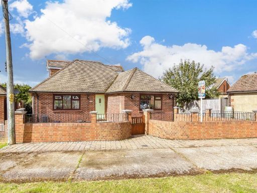 3 bedroom chalet for sale in Rushetts Road, West Kingsdown, Sevenoaks, Kent, TN15 — £326,500 • 3 bed • 1 bath • 1066 ft²
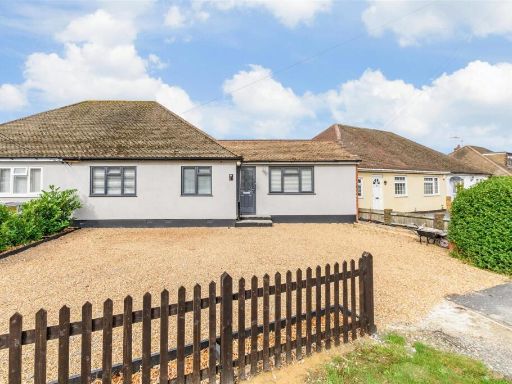 3 bedroom semi-detached bungalow for sale in Hever Avenue, West Kingsdown, Sevenoaks, Kent, TN15 — £330,500 • 3 bed • 2 bath • 582 ft²
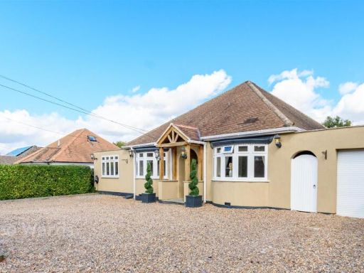 5 bedroom detached bungalow for sale in The Grove, West Kingsdown, Sevenoaks, Kent, TN15 — £726,500 • 5 bed • 2 bath • 1314 ft²
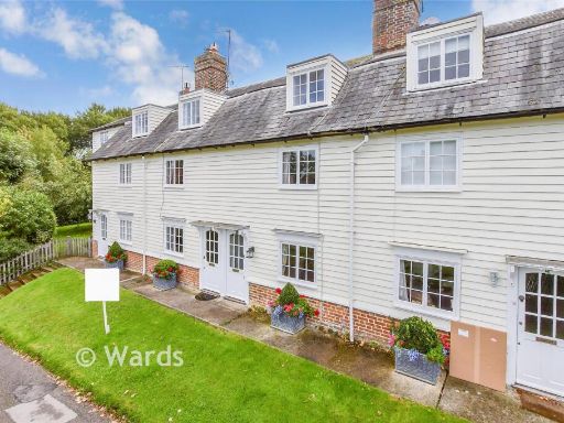 2 bedroom terraced house for sale in Tutsham Farm, West Farleigh, Maidstone, Kent, ME15 — £330,500 • 2 bed • 2 bath • 868 ft²
Meta
- {
"@context": "https://schema.org",
"@type": "Residence",
"name": "2 bedroom terraced house for sale in School Lane, West King…",
"description": "",
"url": "https://propertypiper.co.uk/property/2128b26b-bfdc-4c94-bb2b-dd7b09a470b8",
"image": "https://image-a.propertypiper.co.uk/6c0ce362-5059-4dcc-bd07-32656ff358e3-1024.jpeg",
"address": {
"@type": "PostalAddress",
"streetAddress": "VICTORIA COTTAGES 3 SCHOOL LANE WEST KINGSDOWN SEVENOAKS",
"postalCode": "TN15 6JN",
"addressLocality": "Sevenoaks",
"addressRegion": "Sevenoaks",
"addressCountry": "England"
},
"geo": {
"@type": "GeoCoordinates",
"latitude": 51.3367359,
"longitude": 0.2659606
},
"numberOfRooms": 2,
"numberOfBathroomsTotal": 1,
"floorSize": {
"@type": "QuantitativeValue",
"value": 625,
"unitCode": "FTK"
},
"offers": {
"@type": "Offer",
"price": 271000,
"priceCurrency": "GBP",
"availability": "https://schema.org/InStock"
},
"additionalProperty": [
{
"@type": "PropertyValue",
"name": "Feature",
"value": "Victorian"
},
{
"@type": "PropertyValue",
"name": "Feature",
"value": "terraced house"
},
{
"@type": "PropertyValue",
"name": "Feature",
"value": "brick exterior"
},
{
"@type": "PropertyValue",
"name": "Feature",
"value": "chimney"
},
{
"@type": "PropertyValue",
"name": "Feature",
"value": "small garden"
},
{
"@type": "PropertyValue",
"name": "Feature",
"value": "period property"
},
{
"@type": "PropertyValue",
"name": "Feature",
"value": "roof tiles"
},
{
"@type": "PropertyValue",
"name": "Feature",
"value": "two-story"
},
{
"@type": "PropertyValue",
"name": "Feature",
"value": "front porch"
},
{
"@type": "PropertyValue",
"name": "Feature",
"value": "traditional windows"
},
{
"@type": "PropertyValue",
"name": "Feature",
"value": "garden"
},
{
"@type": "PropertyValue",
"name": "Feature",
"value": "patio"
},
{
"@type": "PropertyValue",
"name": "Feature",
"value": "contemporary"
},
{
"@type": "PropertyValue",
"name": "Feature",
"value": "outdoor space"
},
{
"@type": "PropertyValue",
"name": "Feature",
"value": "fencing"
},
{
"@type": "PropertyValue",
"name": "Feature",
"value": "privacy"
},
{
"@type": "PropertyValue",
"name": "Feature",
"value": "low maintenance"
},
{
"@type": "PropertyValue",
"name": "Feature",
"value": "landscaping"
},
{
"@type": "PropertyValue",
"name": "Feature",
"value": "paved"
},
{
"@type": "PropertyValue",
"name": "Feature",
"value": "urban"
},
{
"@type": "PropertyValue",
"name": "Feature",
"value": "seating area"
}
]
}
High Res Floorplan Images
Compatible Floorplan Images
FloorplanImages Thumbnail