BB10 1YB - 2 bedroom bungalow for sale in Highfield Avenue, Burnley, B…
View on Property Piper
2 bedroom bungalow for sale in Highfield Avenue, Burnley, BB10
Property Details
- Price: £200000
- Bedrooms: 2
- Bathrooms: 1
- Property Type: undefined
- Property SubType: undefined
Brochure Descriptions
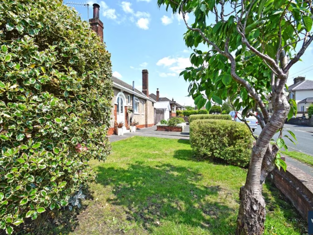
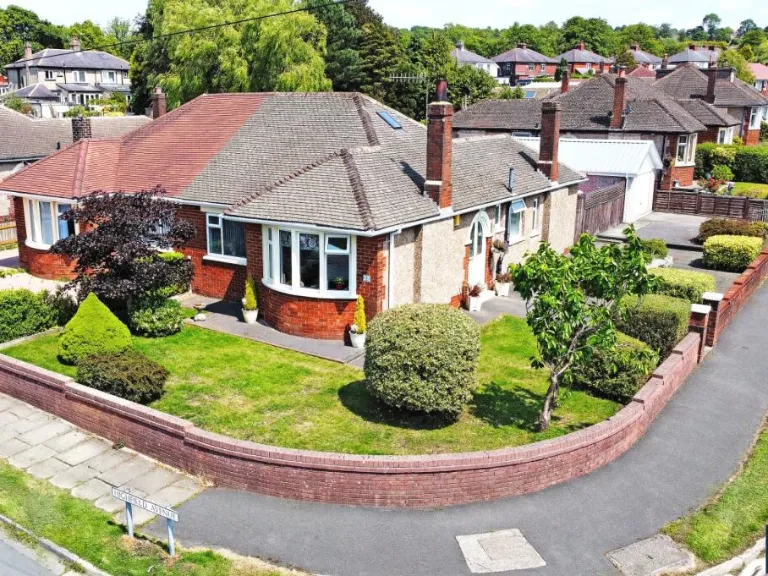
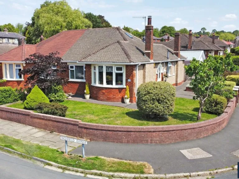
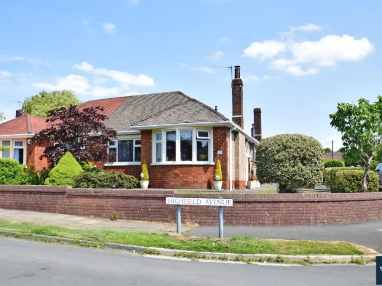
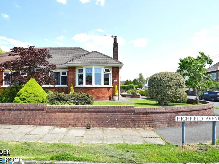
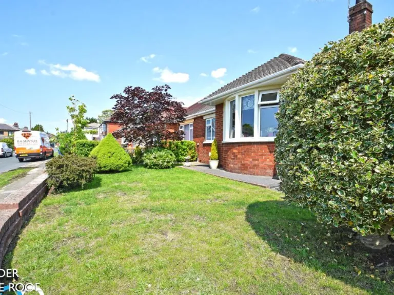
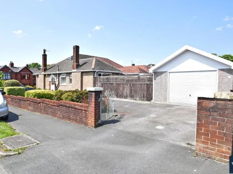
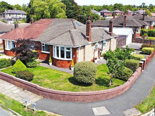
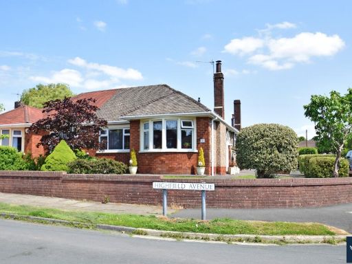
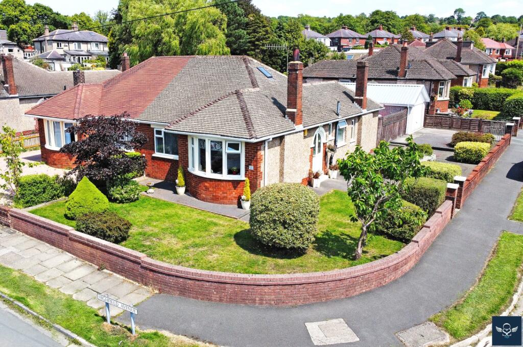
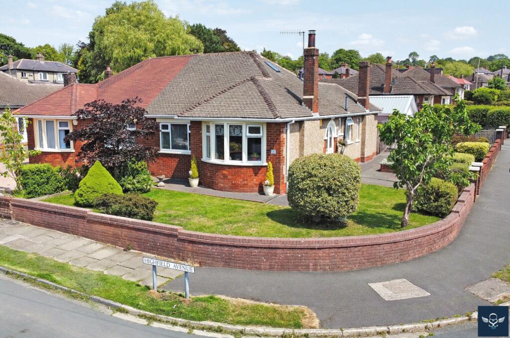
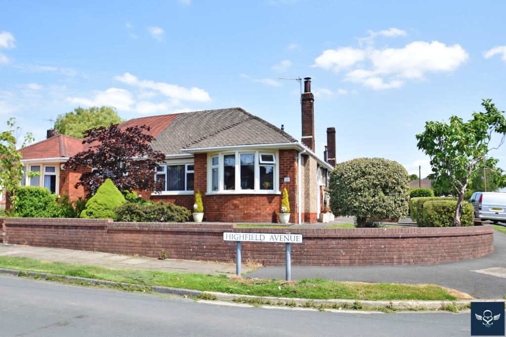
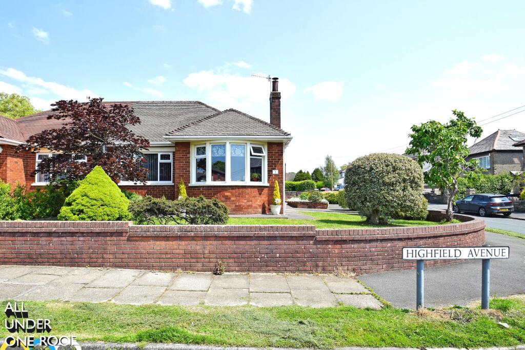
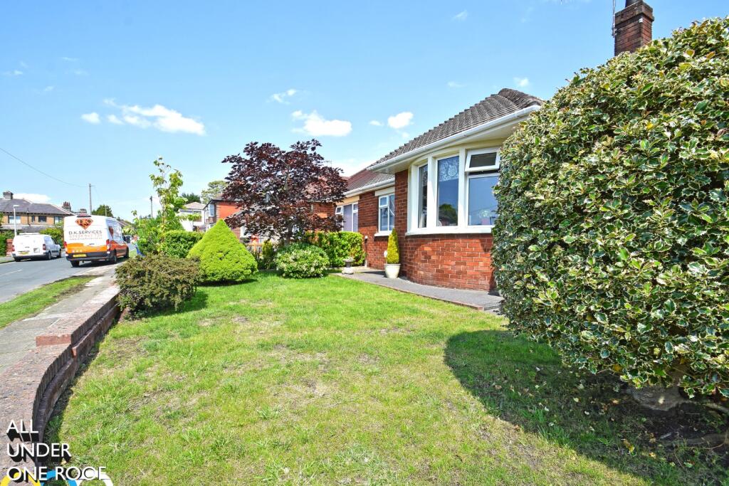
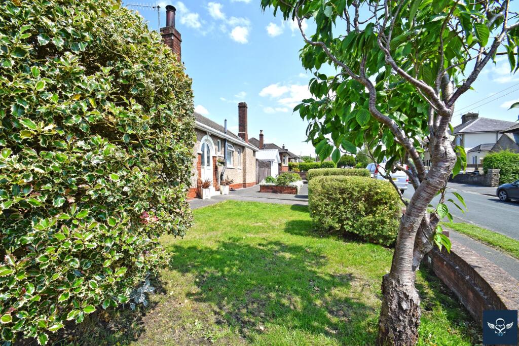
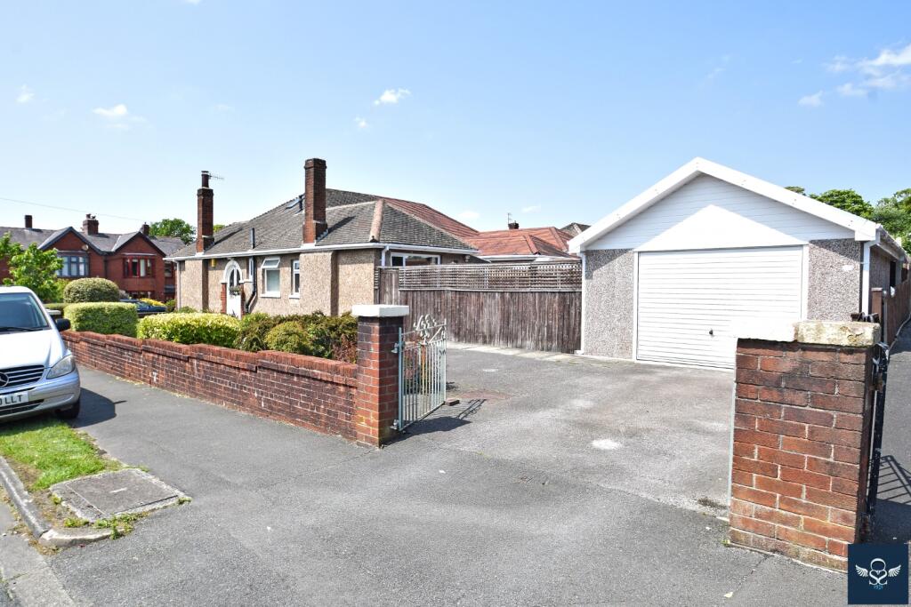
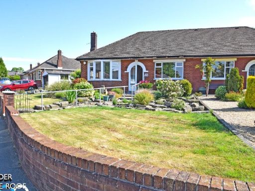
- The property is an attractively refurbished brick-built bungalow positioned on an elevated corner plot in a desirable residential area close to the General Hospital. The bungalow boasts a well-maintained exterior with a landscaped garden that is of an average size, providing both functionality and aesthetic appeal. Its elevated position likely offers modest views over the surrounding residential neighborhood. This property is ideal for couples or those looking to downsize, given its manageable size and practical layout.
Image Descriptions
- single-story brick house bungalow
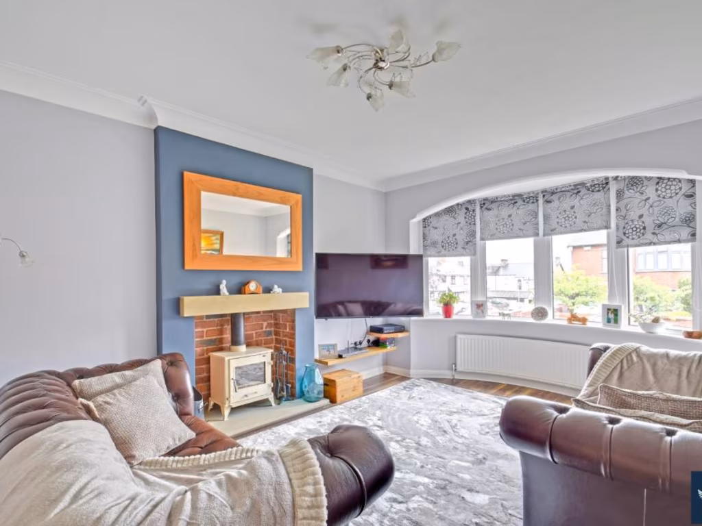
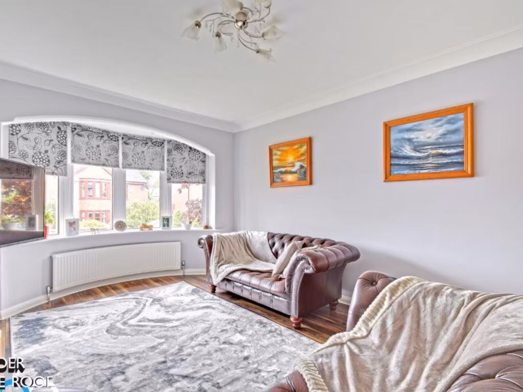
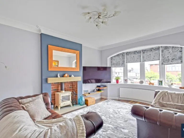
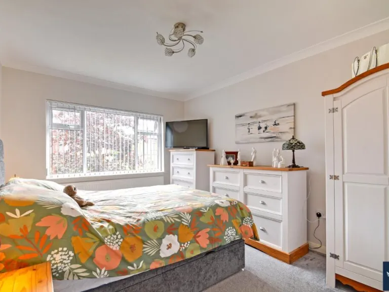
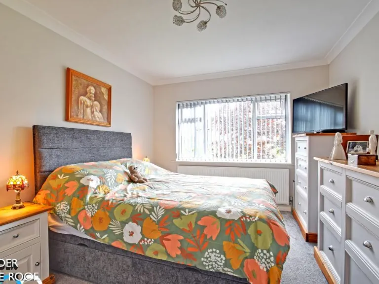
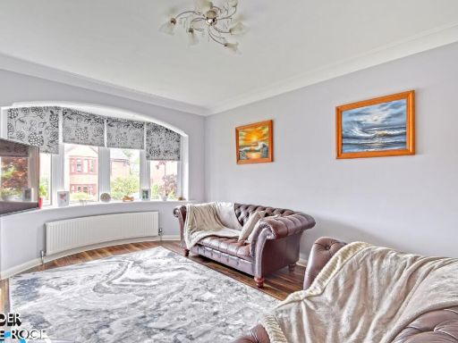
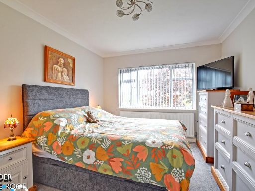
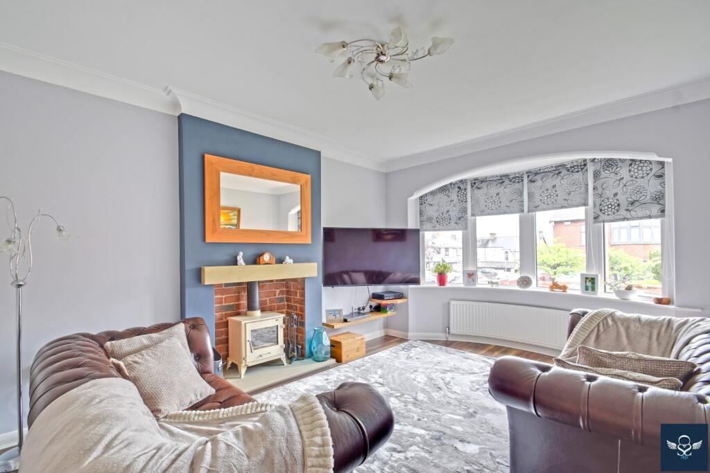
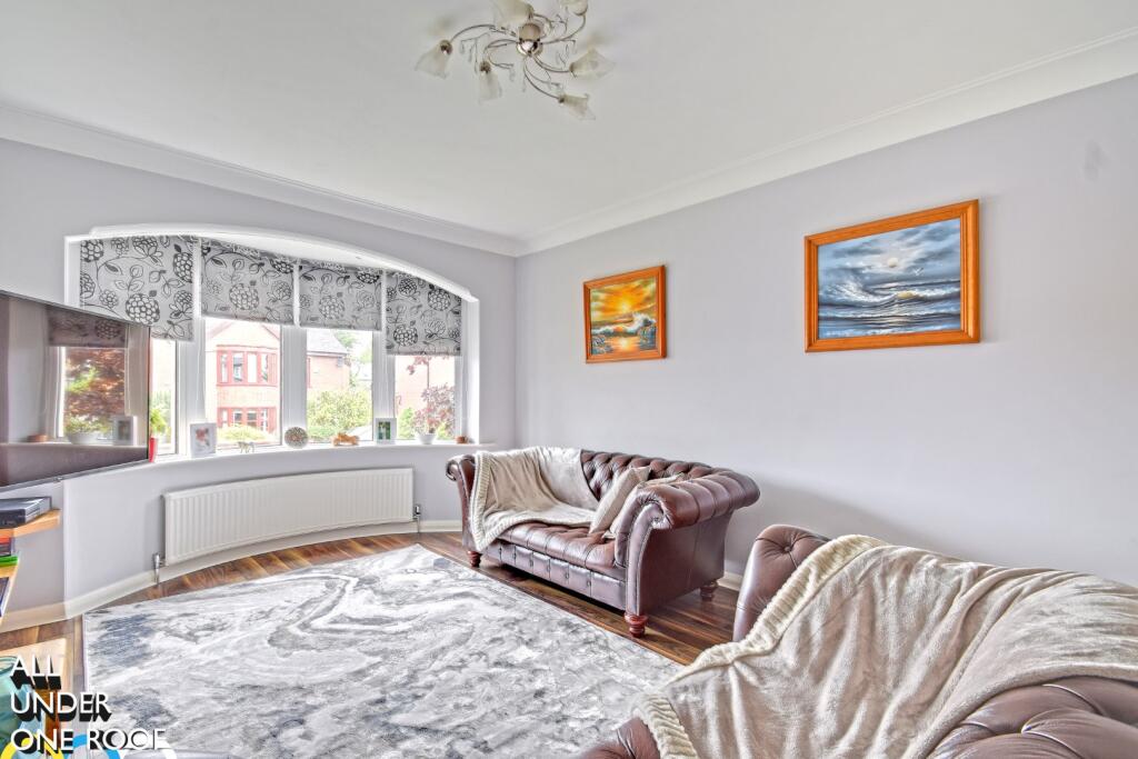
- interior living room Modern
Floorplan Description
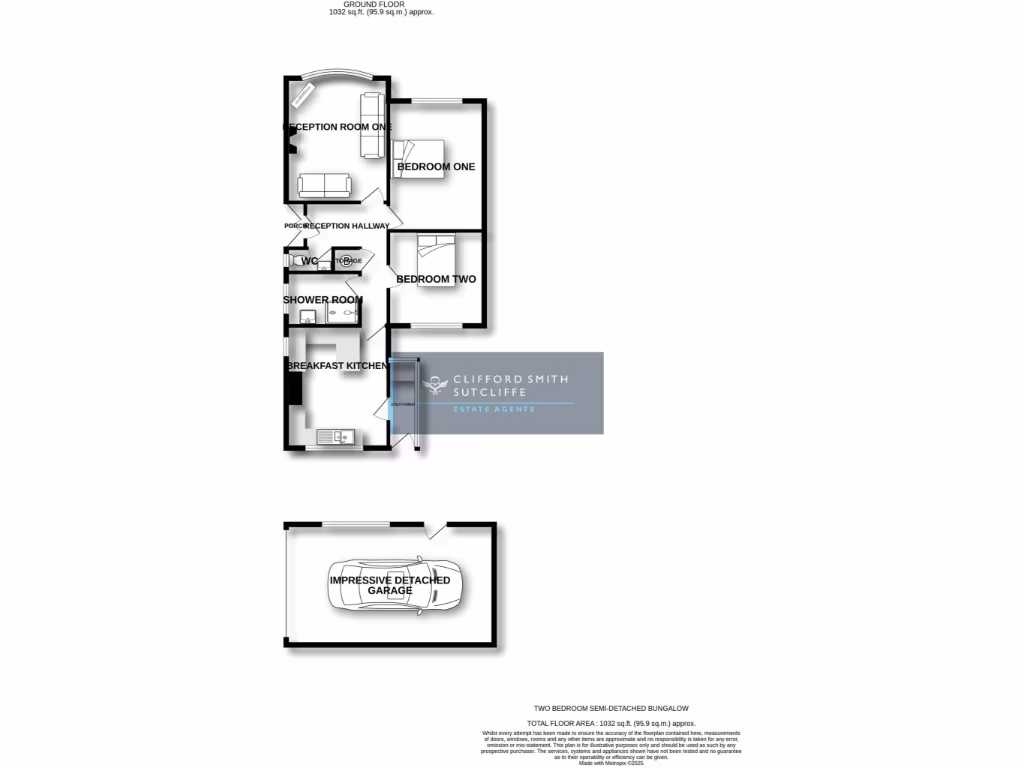
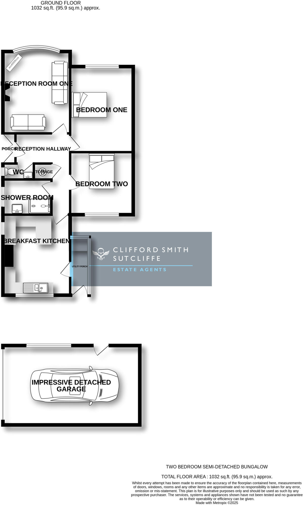
- Two bedroom semi-detached bungalow.
Rooms
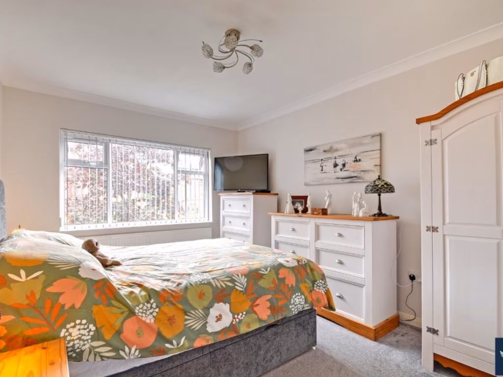
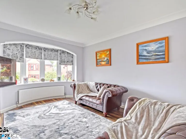
- Reception Room One:
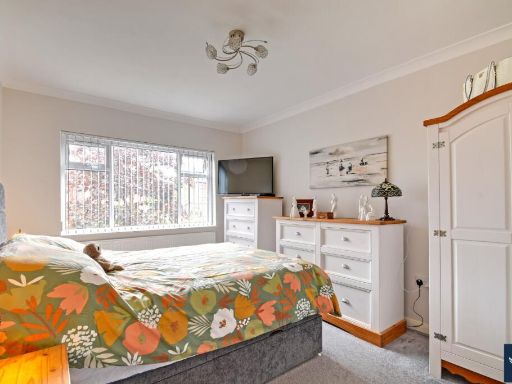
- Bedroom One:
- Bedroom Two:
- Reception Hallway:
- WC:
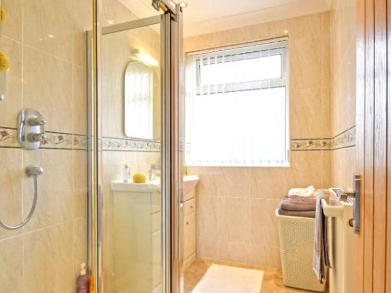
- Shower Room:
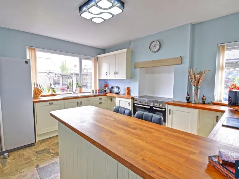
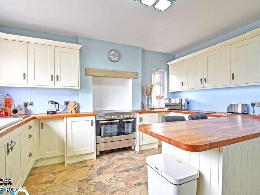
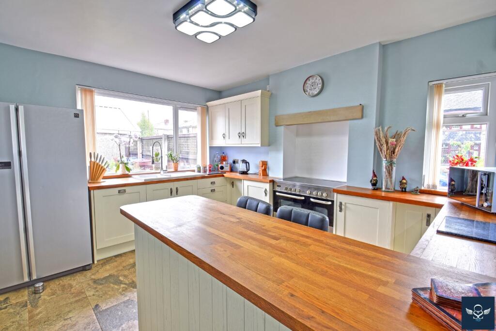
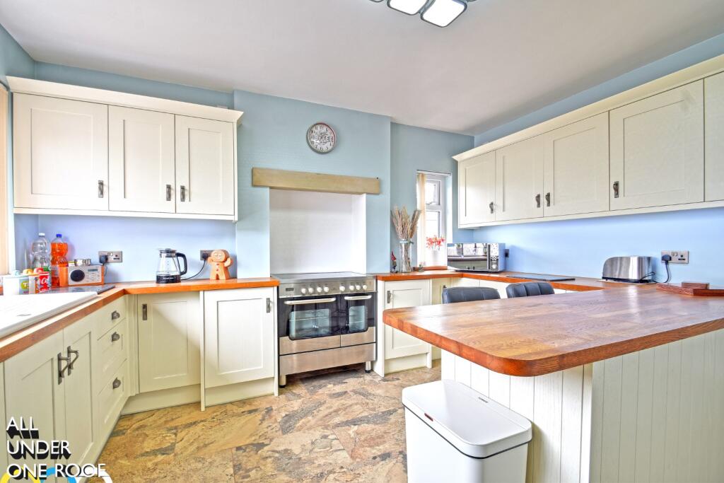
- Breakfast Kitchen:
- Utility Porch:
- Porch:
Textual Property Features
Detected Visual Features
- bungalow
- brick
- single-story
- bay windows
- chimneys
- garden
- detached
- modern
- living room
- fireplace
- bay window
- radiator
- standard ceiling
- medium room
EPC Details
- Fully double glazed
- Cavity wall, filled cavity
- Boiler and radiators, mains gas
- Low energy lighting in all fixed outlets
- Suspended, no insulation (assumed)
Nearby Schools
- Burnley Stoneyholme Community Primary School
- Rawdhatul Uloom
- Heasandford Primary School
- Casterton Primary Academy
- Nelson St Paul's Church of England Primary School
- Burnley St Peter's Church of England Primary School
- The Heights Burnley
- St James' Lanehead Church of England Primary School
- Reedley Primary School
- Holy Trinity Roman Catholic Primary School, a Voluntary Academy
- Whitefield Infant School and Nursery
- Al-Ikhlaas Primary School
- Lomeshaye Junior School
- Burnley Springfield Community Primary School
- Olive High
- Blessed Trinity Roman Catholic College, A Voluntary Academy
- Burnley St Stephen's Church of England Voluntary Aided Primary School
- St Mary's RC Primary School, a Voluntary Academy
- Lincoln House School
- Olive High Boys
- Sir John Thursby Community College
- Barden Primary School
- St John the Baptist RC Primary School, a Voluntary Academy
- Pendle Primary Academy
- Marsden Heights Community College
- Marsden Community Primary School
- St John Southworth RC Primary School, A Voluntary Academy
Nearest Bars And Restaurants
- Id: 36931377
- Tags:
- Addr:
- City: Burnley
- Postcode: BB10 3EF
- Street: Queen Victoria Road
- Amenity: pub
- Building: yes
- Name: The Queen Victoria
- Source: yahoo_imagery
- Website: https://www.brewersfayre.co.uk/
- TagsNormalized:
- Lat: 53.7964765
- Lon: -2.233522
- FullGeoHash: gcw6j1me5nj6
- PartitionGeoHash: gcw6
- Images:
- FoodStandards: null
- Distance: 1655.3
,- Id: 479720331
- Tags:
- Addr:
- City: Burnley
- Housename: Eastern Avenue Service Station
- Postcode: BB10 2AR
- Street: Eastern Avenue
- Amenity: fast_food
- Brand: Subway
- Brand:wikidata: Q244457
- Brand:wikipedia: en:Subway (restaurant)
- Building: yes
- Contact:
- Website: https://restaurants.subway.com/united-kingdom/en/burnley/eastern-avenue-service-stationeastern-ave
- Cuisine: sandwich
- Name: Subway
- Takeaway: yes
- TagsNormalized:
- fast food
- food
- sandwich
- takeaway
- Lat: 53.8022428
- Lon: -2.2234723
- FullGeoHash: gcw6j6kuv2fz
- PartitionGeoHash: gcw6
- Images:
- FoodStandards: null
- Distance: 1187
,- Id: 154914789
- Tags:
- Amenity: pub
- Created_by: JOSM
- Name: Duke of York
- TagsNormalized:
- Lat: 53.801519
- Lon: -2.2359315
- FullGeoHash: gcw6j47be409
- PartitionGeoHash: gcw6
- Images:
- FoodStandards: null
- Distance: 1112.2
,- Id: 746407371
- Tags:
- Amenity: cafe
- Building: yes
- Name: Simply Classic Bistro & Bar
- TagsNormalized:
- Lat: 53.8122321
- Lon: -2.2369408
- FullGeoHash: gcw6jh5ngx0h
- PartitionGeoHash: gcw6
- Images:
- FoodStandards: null
- Distance: 283.8
,- Id: 477350652
- Tags:
- Addr:
- City: Burnley
- Postcode: BB10 1HW
- Street: Keswick Road
- Amenity: pub
- Building: yes
- Name: The Prairie
- Website: sizzlingpubs.co.uk
- TagsNormalized:
- Lat: 53.8097114
- Lon: -2.2350787
- FullGeoHash: gcw6j5u2qchx
- PartitionGeoHash: gcw6
- Images:
- FoodStandards: null
- Distance: 233.1
}
Nearest General Shops
- Id: 945498689
- Tags:
- Building: yes
- Second_hand: only
- Shop: car
- TagsNormalized:
- Lat: 53.8011355
- Lon: -2.2270109
- FullGeoHash: gcw6j64q6fs6
- PartitionGeoHash: gcw6
- Images:
- FoodStandards: null
- Distance: 1200.2
,- Id: 479720332
- Tags:
- Addr:
- City: Burnley
- Housename: Eastern Avenue Service Station
- Postcode: BB10 2AR
- Street: Eastern Avenue
- Brand: Spar
- Brand:wikidata: Q610492
- Brand:wikipedia: en:Spar (retailer)
- Building: yes
- Name: Spar
- Shop: supermarket
- TagsNormalized:
- Lat: 53.8022275
- Lon: -2.2232684
- FullGeoHash: gcw6j6mhdn4u
- PartitionGeoHash: gcw6
- Images:
- FoodStandards: null
- Distance: 1195.4
,- Id: 477350648
- Tags:
- Addr:
- City: Burnley
- Housenumber: 153
- Postcode: BB10 1EH
- Street: Colne Road
- Brand: Home Bargains
- Brand:wikidata: Q5888229
- Brand:wikipedia: en:Home Bargains
- Building: yes
- Contact:
- Website: https://storelocator.homebargains.co.uk/store/A316/Colne+Road,+Burnley
- Name: Home Bargains
- Shop: variety_store
- TagsNormalized:
- home bargains
- variety store
- shop
- Lat: 53.8035562
- Lon: -2.2331094
- FullGeoHash: gcw6j4tukvbf
- PartitionGeoHash: gcw6
- Images:
- FoodStandards: null
- Distance: 867.6
}
Nearest Grocery shops
- Id: 571040547
- Tags:
- Brand: Premier
- Brand:wikidata: Q7240340
- Brand:wikipedia: en:Premier Stores
- Building: yes
- Name: Premier
- Shop: convenience
- TagsNormalized:
- Lat: 53.8136609
- Lon: -2.219844
- FullGeoHash: gcw6jkrx3ckr
- PartitionGeoHash: gcw6
- Images:
- FoodStandards: null
- Distance: 893.4
,- Id: 1392105967
- Tags:
- TagsNormalized:
- Lat: 53.8054194
- Lon: -2.2305883
- FullGeoHash: gcw6j4zxr90u
- PartitionGeoHash: gcw6
- Images:
- FoodStandards: null
- Distance: 677.3
,- Id: 473868295
- Tags:
- Addr:
- City: Burnley
- Postcode: BB10 2PA
- Street: Casterton Avenue
- Brand: Tesco Express
- Brand:wikidata: Q98456772
- Building: yes
- Contact:
- Website: https://www.tesco.com/store-locator/burnley/casterton-ave
- Name: Tesco Express
- Shop: convenience
- TagsNormalized:
- tesco
- tesco express
- convenience
- shop
- Lat: 53.8098829
- Lon: -2.2261736
- FullGeoHash: gcw6j7fcq3hw
- PartitionGeoHash: gcw6
- Images:
- FoodStandards: null
- Distance: 469.9
}
Nearest Religious buildings
- Id: 446880948
- Tags:
- Addr:
- City: Burnley
- Country: GB
- Postcode: BB10 2NH
- Street: Briercliffe Road
- Alt_name: St James' Lanehead Church Of England Primary School
- Amenity: school
- Name: Burnley St James' Lanehead Church of England Primary School
- Phone: +44 1282 426833
- Ref:
- Source:
- Addr: edubase
- Geometry: OS_Open_Map_Local_FunctionalSite
- Name: edubase
- Website: https://www.st-jameslanehead.lancs.sch.uk/
- Wikidata: Q66137703
- TagsNormalized:
- Lat: 53.8095424
- Lon: -2.2170516
- FullGeoHash: gcw6je9x6cwx
- PartitionGeoHash: gcw6
- Images:
- FoodStandards: null
- Distance: 1058.7
,- Id: 844007286
- Tags:
- Amenity: place_of_worship
- Building: church
- Denomination: anglican
- Name: St Andrew with St Margaret and St James
- Religion: christian
- Wikidata: Q7592332
- Wikipedia: en:St Andrew's Church, Burnley
- TagsNormalized:
- place of worship
- church
- anglican
- christian
- Lat: 53.8021086
- Lon: -2.2351585
- FullGeoHash: gcw6j4k7vpcp
- PartitionGeoHash: gcw6
- Images:
- FoodStandards: null
- Distance: 1039.3
,- Id: 844007606
- Tags:
- Amenity: place_of_worship
- Building: church
- Denomination: anglican
- Name: St Cuthbert
- Religion: christian
- Wikidata: Q102318316
- TagsNormalized:
- place of worship
- church
- anglican
- christian
- Lat: 53.8067359
- Lon: -2.2302761
- FullGeoHash: gcw6j5pyyy99
- PartitionGeoHash: gcw6
- Images:
- FoodStandards: null
- Distance: 541.6
}
Nearest Medical buildings
- Id: 170175356
- Tags:
- Amenity: hospital
- Emergency: no
- Healthcare: hospital
- Name: St Peters Centre
- TagsNormalized:
- Lat: 53.7905832
- Lon: -2.2399106
- FullGeoHash: gcw6j02by73x
- PartitionGeoHash: gcw6
- Images:
- FoodStandards: null
- Distance: 2355.7
,- Id: 7497223032
- Tags:
- Addr:
- City: Burnley
- Country: GB
- Postcode: BB12 0EQ
- Street: Princess Way
- Amenity: pharmacy
- Brand: Asda
- Brand:wikidata: Q297410
- Brand:wikipedia: en:Asda
- Contact:
- Phone: +44 1282 838177
- Website: https://storelocator.asda.com/north-west/burnley/princess-way/pharmacy
- Fhrs:
- Fixme: Location not accurate
- Healthcare: pharmacy
- Name: Asda
- Operator: Asda Stores Ltd
- TagsNormalized:
- pharmacy
- asda
- health
- healthcare
- Lat: 53.7952015
- Lon: -2.2443386
- FullGeoHash: gcw6hcjez07u
- PartitionGeoHash: gcw6
- Images:
- FoodStandards: null
- Distance: 1947.7
,- Id: 945058150
- Tags:
- Amenity: doctors
- Building: yes
- Healthcare: doctor
- TagsNormalized:
- doctor
- doctors
- health
- healthcare
- Lat: 53.7948954
- Lon: -2.2413577
- FullGeoHash: gcw6hcpcux6d
- PartitionGeoHash: gcw6
- Images:
- FoodStandards: null
- Distance: 1913.3
,- Id: 479911178
- Tags:
- Addr:
- City: Burnley
- Postcode: BB10 2PQ
- Street: Casterton Avenue
- Amenity: hospital
- Emergency: yes
- Healthcare: hospital
- Name: Burnley General Hospital
- Operator: National Health Service
- Website: nhs.uk
- Wikidata: Q27943307
- TagsNormalized:
- hospital
- health
- healthcare
- general
- Lat: 53.8089043
- Lon: -2.2284133
- FullGeoHash: gcw6j797d4y8
- PartitionGeoHash: gcw6
- Images:
- FoodStandards: null
- Distance: 400.6
}
Nearest Leisure Facilities
- Id: 170297350
- Tags:
- Leisure: park
- Name: Stock Park
- TagsNormalized:
- Lat: 53.8070026
- Lon: -2.2373759
- FullGeoHash: gcw6j56b9278
- PartitionGeoHash: gcw6
- Images:
- FoodStandards: null
- Distance: 567.1
,- Id: 1150783007
- Tags:
- Leisure: pitch
- Sport: rugby_union
- TagsNormalized:
- pitch
- leisure
- rugby
- rugby union
- sports
- Lat: 53.8126139
- Lon: -2.2401368
- FullGeoHash: gcw6jh2c1n2c
- PartitionGeoHash: gcw6
- Images:
- FoodStandards: null
- Distance: 496.5
,- Id: 912976878
- Tags:
- Leisure: pitch
- Sport: bowls
- TagsNormalized:
- Lat: 53.8074781
- Lon: -2.2355032
- FullGeoHash: gcw6j5k5kbzv
- PartitionGeoHash: gcw6
- Images:
- FoodStandards: null
- Distance: 464.5
,- Id: 1150783006
- Tags:
- Leisure: pitch
- Sport: soccer
- TagsNormalized:
- Lat: 53.8132959
- Lon: -2.2382324
- FullGeoHash: gcw6jh6jjmkv
- PartitionGeoHash: gcw6
- Images:
- FoodStandards: null
- Distance: 412.2
,- Id: 746407370
- Tags:
- Leisure: pitch
- Name: Prairie Sports Village
- Sport: soccer
- TagsNormalized:
- Lat: 53.8126275
- Lon: -2.2359777
- FullGeoHash: gcw6jh7c3by4
- PartitionGeoHash: gcw6
- Images:
- FoodStandards: null
- Distance: 247.6
}
Nearest Tourist attractions
- Id: 1730727200
- Tags:
- Addr:
- City: Nelson
- Housename: Hendon Mill
- Postcode: BB9 8AD
- Street: Hallam Road
- Name: British in India
- Opening_hours: Mo-Fr 09:00-16:00
- Tourism: museum
- Website: https://www.visitpendle.com/things-to-do/british-in-india-museum-p7152
- Wikidata: Q113280064
- TagsNormalized:
- Lat: 53.8394735
- Lon: -2.2011897
- FullGeoHash: gcw6mcjjst3c
- PartitionGeoHash: gcw6
- Images:
- FoodStandards: null
- Distance: 3755
,- Id: 788205301
- Tags:
- Addr:
- City: Harle Syke, Burnley
- Postcode: BB10 2HX
- Street: Queen Street
- Museum: industrial
- Name: Queen Street Mill Textile Museum
- Operator: Lancashire County Council
- Operator:type: public
- Tourism: museum
- Website: https://www.lancashire.gov.uk/leisure-and-culture/museums/queen-street-mill-textile-museum/
- Wikidata: Q113370012
- TagsNormalized:
- Lat: 53.8102317
- Lon: -2.2018909
- FullGeoHash: gcw6jguek4pp
- PartitionGeoHash: gcw6
- Images:
- FoodStandards: null
- Distance: 2038.5
,- Id: 1371242127
- Tags:
- Name: Ormerod
- Tourism: guest_house
- TagsNormalized:
- Lat: 53.794089
- Lon: -2.2332877
- FullGeoHash: gcw6j0vv295b
- PartitionGeoHash: gcw6
- Images:
- FoodStandards: null
- Distance: 1920.4
}
Nearest Bus stations and stops
- Id: 4900018103
- Tags:
- Highway: bus_stop
- Name: The Prairie
- Public_transport: platform
- TagsNormalized:
- Lat: 53.8099259
- Lon: -2.2345238
- FullGeoHash: gcw6j5ucec4r
- PartitionGeoHash: gcw6
- Images:
- FoodStandards: null
- Distance: 192.3
,- Id: 4764551941
- Tags:
- Highway: bus_stop
- Name: Windermere Avenue
- Public_transport: platform
- TagsNormalized:
- Lat: 53.8124192
- Lon: -2.2351451
- FullGeoHash: gcw6jhk2j650
- PartitionGeoHash: gcw6
- Images:
- FoodStandards: null
- Distance: 189.8
,- Id: 4764551914
- Tags:
- Highway: bus_stop
- Name: Casterton Avenue
- Public_transport: platform
- TagsNormalized:
- Lat: 53.8116531
- Lon: -2.2347523
- FullGeoHash: gcw6jhhew7py
- PartitionGeoHash: gcw6
- Images:
- FoodStandards: null
- Distance: 127.2
,- Id: 4998648331
- Tags:
- Highway: bus_stop
- Name: Highfield Avenue
- Public_transport: platform
- TagsNormalized:
- Lat: 53.8121319
- Lon: -2.2340556
- FullGeoHash: gcw6jhjnqsrq
- PartitionGeoHash: gcw6
- Images:
- FoodStandards: null
- Distance: 115.6
,- Id: 4998648332
- Tags:
- Highway: bus_stop
- Name: Highfield Avenue
- Public_transport: platform
- TagsNormalized:
- Lat: 53.8121428
- Lon: -2.2331868
- FullGeoHash: gcw6jhjy6yrp
- PartitionGeoHash: gcw6
- Images:
- FoodStandards: null
- Distance: 89.6
}
Nearest Hotels
- Id: 444331855
- Tags:
- Addr:
- City: Burnley
- Street: Barracks Road
- Brand: Travelodge
- Brand:wikidata: Q9361374
- Building: yes
- Internet_access: yes
- Internet_access:fee: customers
- Internet_access:ssid: Travelodge WiFi
- Name: Travelodge
- Smoking: outside
- Stars: 3
- Tourism: hotel
- Website: https://www.travelodge.co.uk
- TagsNormalized:
- Lat: 53.7895033
- Lon: -2.260505
- FullGeoHash: gcw6h81fw6jm
- PartitionGeoHash: gcw6
- Images:
- FoodStandards: null
- Distance: 3032.6
,- Id: 773641254
- Tags:
- Name: Holiday Inn Express Burnley
- Phone: +44 1282 855 955
- Source: OS OpenData StreetView
- Tourism: hotel
- Website: https://www.hiexburnley.com/
- TagsNormalized:
- Lat: 53.7938815
- Lon: -2.2563814
- FullGeoHash: gcw6h8uund24
- PartitionGeoHash: gcw6
- Images:
- FoodStandards: null
- Distance: 2481.5
,- Id: 36931375
- Tags:
- Addr:
- City: Burnley
- Postcode: BB10 3EF
- Street: Queen Victoria Road
- Brand: Premier Inn
- Brand:wikidata: Q2108626
- Building: yes
- Contact:
- Website: https://www.premierinn.com/gb/en/hotels/england/lancashire/burnley/burnley.html
- Name: Premier Inn
- Source: yahoo_imagery
- Tourism: hotel
- TagsNormalized:
- Lat: 53.7965741
- Lon: -2.2329245
- FullGeoHash: gcw6j1q5c06b
- PartitionGeoHash: gcw6
- Images:
- FoodStandards: null
- Distance: 1643.9
}
Tags
- bungalow
- brick
- single-story
- bay windows
- chimneys
- garden
- detached
- modern
- living room
- fireplace
- brick
- bay window
- radiator
- standard ceiling
- medium room
Local Market Stats
- Average Price/sqft: £128
- Avg Income: £36100
- Rental Yield: 4.4%
- Social Housing: 9%
- Planning Success Rate: 81%
Similar Properties
 3 bedroom bungalow for sale in Laurier Road, Burnley, BB10 — £185,000 • 3 bed • 1 bath • 884 ft²
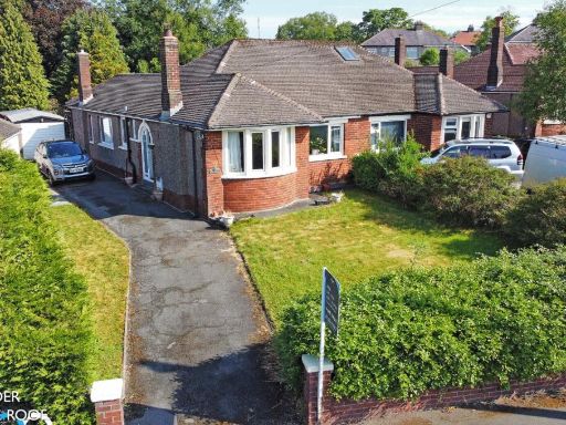 3 bedroom bungalow for sale in Fifth Avenue, Burnley, BB10 — £200,000 • 3 bed • 1 bath • 806 ft²
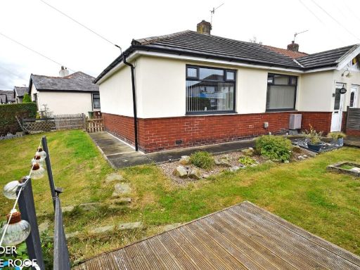 2 bedroom bungalow for sale in Brownside Road, Burnley, BB10 — £200,000 • 2 bed • 1 bath • 647 ft²
 2 bedroom semi-detached bungalow for sale in Dyneley Avenue, Cliviger BB10 — £230,000 • 2 bed • 1 bath • 1184 ft²
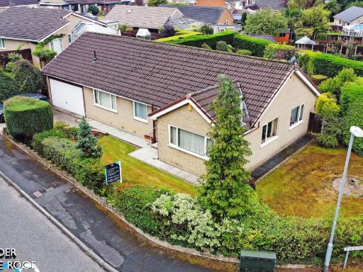 3 bedroom bungalow for sale in Borrowdale Drive, Burnley, BB10 — £325,000 • 3 bed • 2 bath
 2 bedroom bungalow for sale in Garswood Close, Burnley, Lancashire, BB12 — £190,000 • 2 bed • 2 bath • 1049 ft²
Meta
- {
"@context": "https://schema.org",
"@type": "Residence",
"name": "2 bedroom bungalow for sale in Highfield Avenue, Burnley, B…",
"description": "",
"url": "https://propertypiper.co.uk/property/080f504d-e527-437d-bf9b-04f897610560",
"image": "https://image-a.propertypiper.co.uk/136103fa-9817-4a56-b159-cd49008850de-1024.jpeg",
"address": {
"@type": "PostalAddress",
"streetAddress": "1 HIGHFIELD AVENUE BURNLEY",
"postalCode": "BB10 1YB",
"addressLocality": "Burnley",
"addressRegion": "Burnley",
"addressCountry": "England"
},
"geo": {
"@type": "GeoCoordinates",
"latitude": 53.8113578060029,
"longitude": -2.2328802968171924
},
"numberOfRooms": 2,
"numberOfBathroomsTotal": 1,
"floorSize": {
"@type": "QuantitativeValue",
"value": 1032,
"unitCode": "FTK"
},
"offers": {
"@type": "Offer",
"price": 200000,
"priceCurrency": "GBP",
"availability": "https://schema.org/InStock"
},
"additionalProperty": [
{
"@type": "PropertyValue",
"name": "Feature",
"value": "bungalow"
},
{
"@type": "PropertyValue",
"name": "Feature",
"value": "brick"
},
{
"@type": "PropertyValue",
"name": "Feature",
"value": "single-story"
},
{
"@type": "PropertyValue",
"name": "Feature",
"value": "bay windows"
},
{
"@type": "PropertyValue",
"name": "Feature",
"value": "chimneys"
},
{
"@type": "PropertyValue",
"name": "Feature",
"value": "garden"
},
{
"@type": "PropertyValue",
"name": "Feature",
"value": "detached"
},
{
"@type": "PropertyValue",
"name": "Feature",
"value": "modern"
},
{
"@type": "PropertyValue",
"name": "Feature",
"value": "living room"
},
{
"@type": "PropertyValue",
"name": "Feature",
"value": "fireplace"
},
{
"@type": "PropertyValue",
"name": "Feature",
"value": "brick"
},
{
"@type": "PropertyValue",
"name": "Feature",
"value": "bay window"
},
{
"@type": "PropertyValue",
"name": "Feature",
"value": "radiator"
},
{
"@type": "PropertyValue",
"name": "Feature",
"value": "standard ceiling"
},
{
"@type": "PropertyValue",
"name": "Feature",
"value": "medium room"
}
]
}
High Res Floorplan Images
Compatible Floorplan Images
FloorplanImages Thumbnail