PA44 7PZ - Plot for sale in Mulindry Plot 3A , PA44 7PZ, PA44
View on Property Piper
Plot for sale in Mulindry Plot 3A , PA44 7PZ, PA44
Property Details
- Price: £80000
- Bedrooms: 1
- Bathrooms: 1
- Property Type: undefined
- Property SubType: undefined
Brochure Descriptions
- Site plan for a proposed residential development comprising two detached houses (Plot A and Plot B) on a single elongated parcel accessed by a private access track/driveway from the public road. The houses are positioned in the northern part of the site with a long, narrow access drive leading south from the highway. The plan shows dedicated vehicle turning/parking areas adjacent to each proposed house, refuse collection points near the road, and a small treatment plant with a discharge to a burn located along the drive. The site is rural and appears to be a standalone plot with surrounding undeveloped land; no significant built neighbours are shown. Plot sizes appear modest-to-average for rural plots (houses set within their own curtilages) while the overall property footprint is elongated and medium-to-large in total land area due to the long access strip. No internal room layouts or furniture are shown.
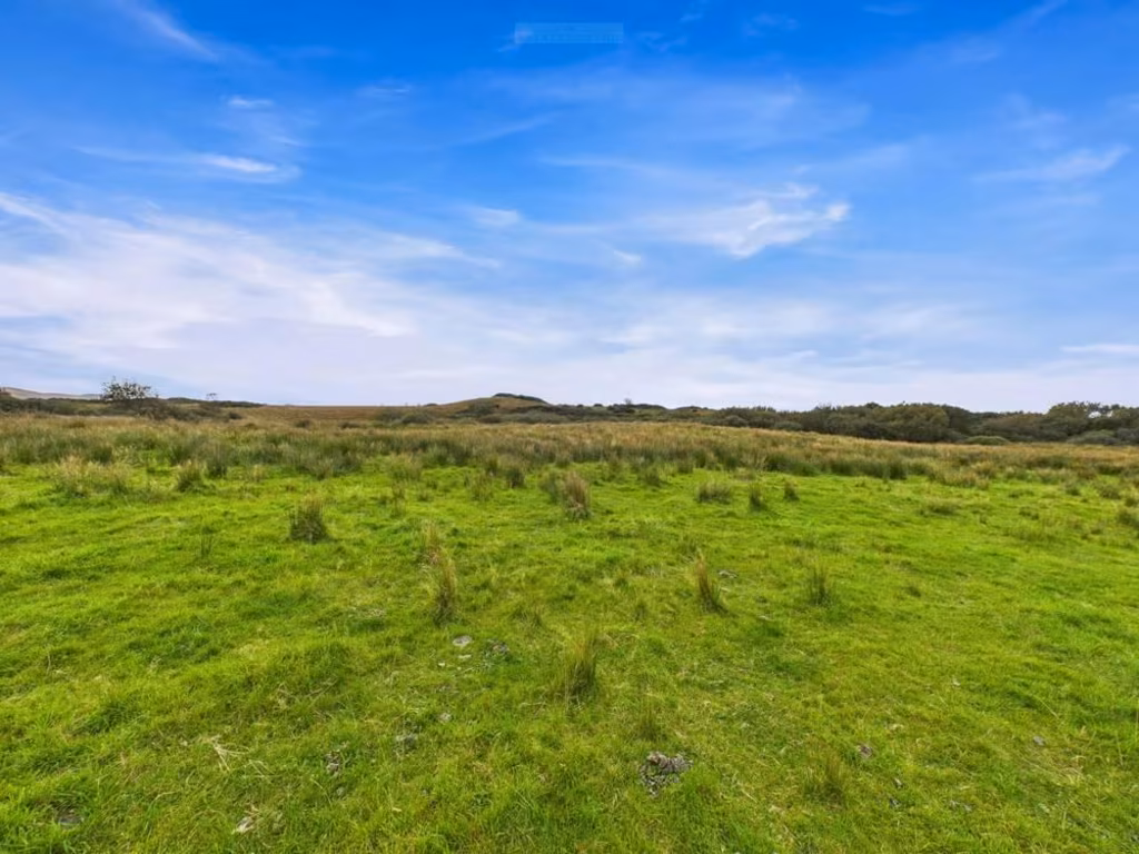
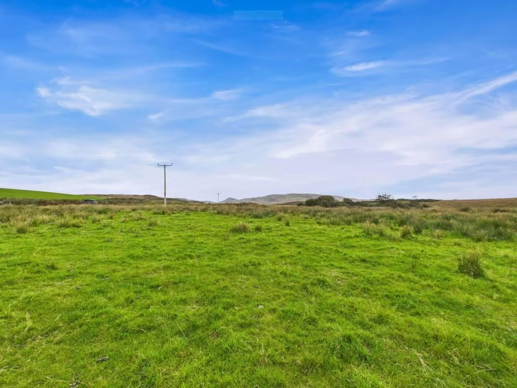
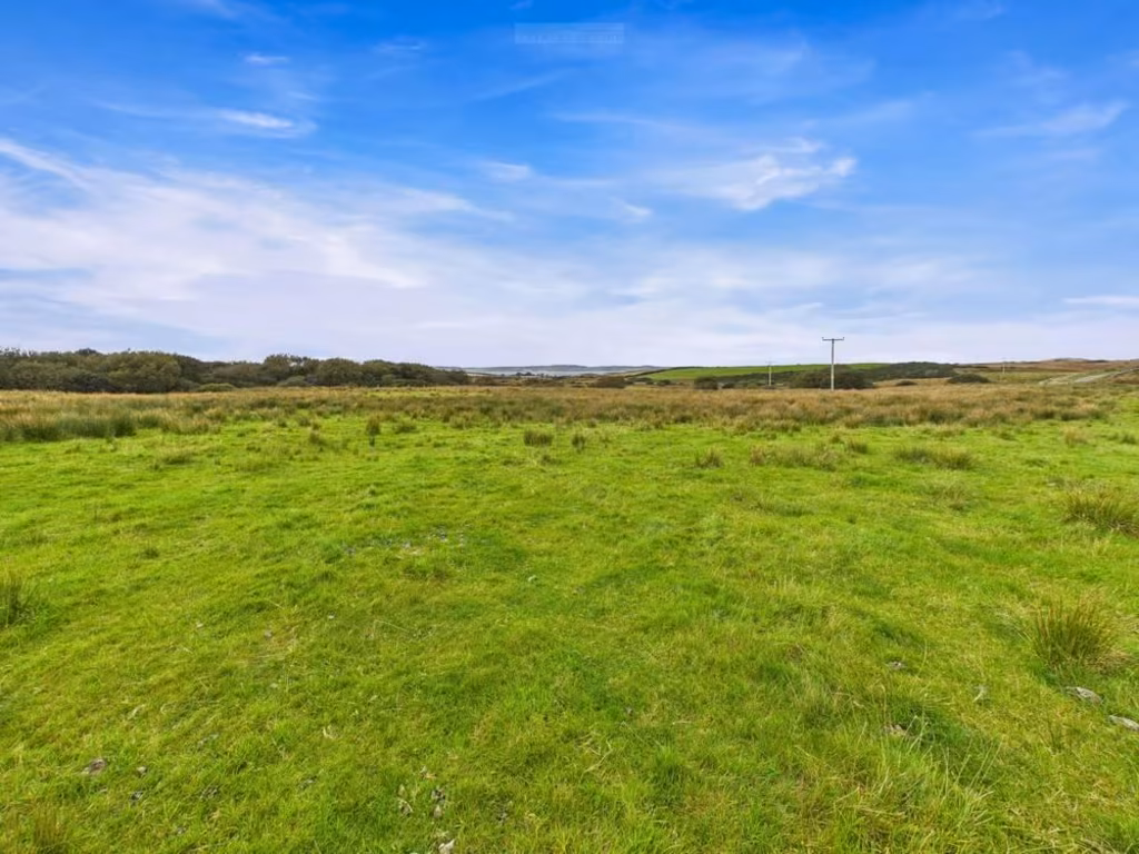
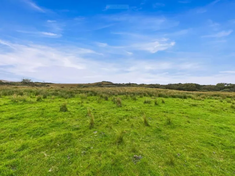
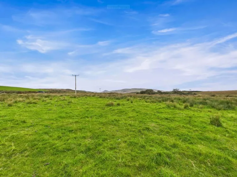
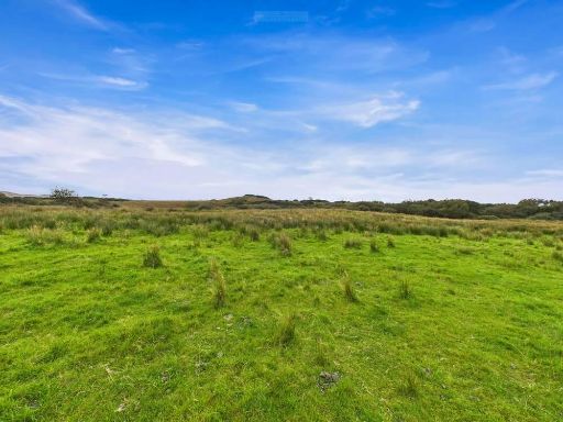
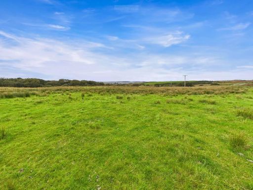
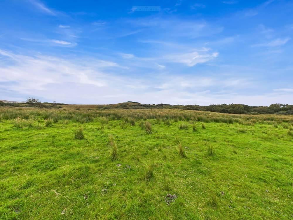
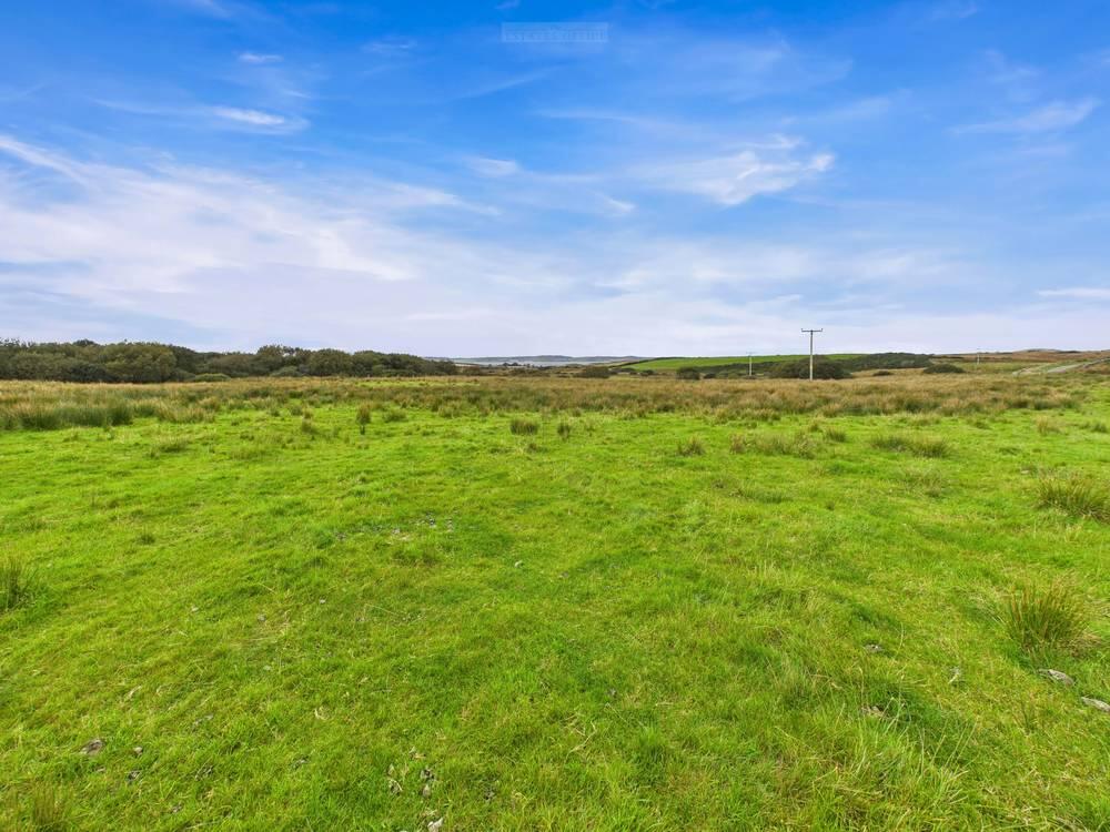
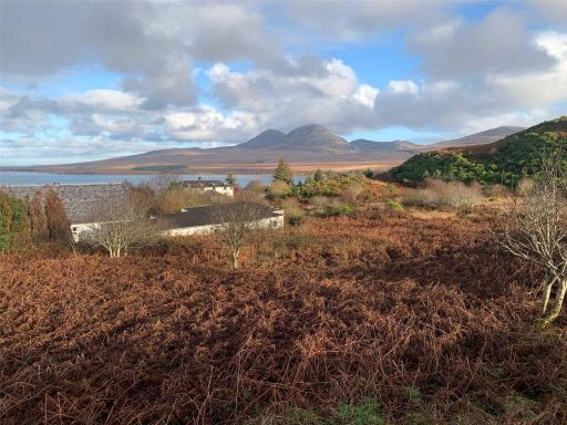
- Rural development site shown as an application site for two residential plots on land at Neriby, Isle of Islay. The site is in a remote, predominantly agricultural / open moorland setting east of Bowmore, set on gently to moderately sloping ground. From the mapped location the land is elevated relative to nearby lowlands and is likely to afford distant views toward the western coastline and surrounding rolling hills. Access is along minor local roads; the immediate area is sparsely developed with scattered farms/holdings. Plot size appears small-to-average for rural house plots (sufficient for dwelling and garden), overall property scale is small (two plots within a larger agricultural parcel).
Textual Property Features
Detected Visual Features
- land
- plot
- rural
- undeveloped
- open space
- countryside
- potential
- green land
- investment
- development opportunity
- greenfield
Nearest Bars And Restaurants
- Id: 9764743518
- Tags:
- Amenity: cafe
- Name: The Cottage Cafe
- Payment:
- Takeaway: yes
- TagsNormalized:
- Lat: 55.7566568
- Lon: -6.2875338
- FullGeoHash: gcgt0yjw1f4v
- PartitionGeoHash: gcgt
- Images:
- FoodStandards: null
- Distance: 5103.3
,- Id: 6488101706
- Tags:
- Amenity: cafe
- Name: The Munchie Box
- Takeaway: only
- TagsNormalized:
- Lat: 55.7555163
- Lon: -6.2870281
- FullGeoHash: gcgt0vvzmts1
- PartitionGeoHash: gcgt
- Images:
- FoodStandards: null
- Distance: 5095.4
,- Id: 3085004290
- Tags:
- Amenity: restaurant
- Cuisine: indian
- Name: Taj Mahal
- TagsNormalized:
- Lat: 55.7571746
- Lon: -6.2865751
- FullGeoHash: gcgt0yq304tv
- PartitionGeoHash: gcgt
- Images:
- FoodStandards: null
- Distance: 5034.5
,- Id: 5073790225
- Tags:
- Addr:
- City: Bowmore
- Housenumber: 22
- Postcode: PA43 7LB
- Street: Shore Street
- Amenity: restaurant
- Cuisine: pizza
- Name: Peatzeria
- Opening_hours: Mo-Su 12:00-22:00
- Payment:
- Phone: +44 1496 810810
- Takeaway: yes
- Website: https://peatzeria.com/
- TagsNormalized:
- Lat: 55.7574235
- Lon: -6.2861396
- FullGeoHash: gcgt0yqdd34d
- PartitionGeoHash: gcgt
- Images:
- FoodStandards: null
- Distance: 5003.2
,- Id: 4521311868
- Tags:
- Amenity: cafe
- Internet_access: wlan
- Name: Cafe Blasta
- Name:gd: Cafaidh Blasta
- Opening_hours: Mo-Fr 10:00-15:30
- Toilets: yes
- Toilets:wheelchair: yes
- Wheelchair: yes
- TagsNormalized:
- Lat: 55.7624158
- Lon: -6.2688995
- FullGeoHash: gcgt1r5ps59w
- PartitionGeoHash: gcgt
- Images:
- FoodStandards: null
- Distance: 3869.4
}
Nearest General Shops
- Id: 4153525689
- Tags:
- Name: White Room
- Shop: gift
- TagsNormalized:
- Lat: 55.7846508
- Lon: -6.2509781
- FullGeoHash: gcgt3g21jssg
- PartitionGeoHash: gcgt
- Images:
- FoodStandards: null
- Distance: 3542.3
,- Id: 1773053675
- Tags:
- Name: Carole Hairstylist
- Shop: hairdresser
- TagsNormalized:
- Lat: 55.7812999
- Lon: -6.2498868
- FullGeoHash: gcgt3f8vx5fw
- PartitionGeoHash: gcgt
- Images:
- FoodStandards: null
- Distance: 3262.7
,- Id: 4151573897
- Tags:
- Name: Islay Woollen mill
- Shop: gift
- TagsNormalized:
- Lat: 55.789298
- Lon: -6.2248059
- FullGeoHash: gcgt6k5hpwbm
- PartitionGeoHash: gcgt
- Images:
- FoodStandards: null
- Distance: 2973.3
}
Nearest Grocery shops
- Id: 362612319
- Tags:
- Brand: Co-op Food
- Brand:wikidata: Q3277439
- Brand:wikipedia: en:Co-op Food
- Building: yes
- Name: Co-op Food
- Opening_hours: Mo-Sa 07:00-22:00; Su 10:00-19:30
- Operator: The Co-operative Group
- Operator:wikidata: Q117202
- Shop: convenience
- Wheelchair: yes
- TagsNormalized:
- co-op
- co-op food
- food
- convenience
- shop
- Lat: 55.7568226
- Lon: -6.2874247
- FullGeoHash: gcgt0yjxh3h6
- PartitionGeoHash: gcgt
- Images:
- FoodStandards: null
- Distance: 5093.4
,- Id: 4153525389
- Tags:
- Name: Islay House Gardens
- Shop: greengrocer
- TagsNormalized:
- Lat: 55.7842852
- Lon: -6.2518118
- FullGeoHash: gcgt3epx40rp
- PartitionGeoHash: gcgt
- Images:
- FoodStandards: null
- Distance: 3557.5
,- Id: 533991862
- Tags:
- Amenity: post_office
- Name: Bridgend Shop
- Opening_hours: Mo-Sa 08:00-19:00; Su 10:00-19:00
- Shop: convenience
- TagsNormalized:
- office
- post office
- shop
- convenience
- Lat: 55.7813807
- Lon: -6.2495561
- FullGeoHash: gcgt3f9nng10
- PartitionGeoHash: gcgt
- Images:
- FoodStandards: null
- Distance: 3251
}
Nearest Religious buildings
- Id: 5829136
- Tags:
- Name: Church Plantation
- Natural: wood
- Source: local_knowledge
- Source:geometry: Bing
- Source:name: OS StreetView Open Data
- Type: multipolygon
- TagsNormalized:
- Lat: 55.813982
- Lon: -6.1690175
- FullGeoHash: gcgte8eu52r5
- PartitionGeoHash: gcgt
- Images:
- FoodStandards: null
- Distance: 5999.7
,- Id: 91015010
- Tags:
- Alt_name: The Round Kirk
- Amenity: place_of_worship
- Building: yes
- Denomination: church_of_scotland
- Name: Kilarrow Parish Church
- Religion: christian
- Service_times: Su 10:00
- Wikidata: Q1366926
- Wikipedia: en:Kilarrow Parish Church
- TagsNormalized:
- place of worship
- church
- church of scotland
- parish
- christian
- Lat: 55.7550394
- Lon: -6.286428
- FullGeoHash: gcgt0vykeset
- PartitionGeoHash: gcgt
- Images:
- FoodStandards: null
- Distance: 5069.3
,- Id: 91015037
- Tags:
- Amenity: place_of_worship
- Building: yes
- Name: Islay Baptist Church
- Religion: christian
- Website: https://www.islaybaptistchurch.org.uk/
- TagsNormalized:
- place of worship
- baptist
- church
- christian
- Lat: 55.7563333
- Lon: -6.2864724
- FullGeoHash: gcgt0ynk4tf7
- PartitionGeoHash: gcgt
- Images:
- FoodStandards: null
- Distance: 5044.2
}
Nearest Leisure Facilities
- Id: 398912021
- Tags:
- TagsNormalized:
- Lat: 55.7543622
- Lon: -6.2900368
- FullGeoHash: gcgt0vg8xw2t
- PartitionGeoHash: gcgt
- Images:
- FoodStandards: null
- Distance: 5305.9
,- Id: 303513063
- Tags:
- Building: yes
- Leisure: water_park
- Name: MacTaggart Leisure Centre
- TagsNormalized:
- Lat: 55.7571442
- Lon: -6.2893777
- FullGeoHash: gcgt0yk0yvh0
- PartitionGeoHash: gcgt
- Images:
- FoodStandards: null
- Distance: 5208.2
,- Id: 933636916
- Tags:
- TagsNormalized:
- Lat: 55.7547624
- Lon: -6.2870878
- FullGeoHash: gcgt0vvgh1p8
- PartitionGeoHash: gcgt
- Images:
- FoodStandards: null
- Distance: 5116.2
,- Id: 1104477686
- Tags:
- TagsNormalized:
- Lat: 55.7581133
- Lon: -6.2830417
- FullGeoHash: gcgt1n2yd98t
- PartitionGeoHash: gcgt
- Images:
- FoodStandards: null
- Distance: 4800
,- Id: 557471136
- Tags:
- Leisure: pitch
- Source: Bing
- Sport: bowls
- TagsNormalized:
- Lat: 55.7808311
- Lon: -6.250196
- FullGeoHash: gcgt3f8dzus4
- PartitionGeoHash: gcgt
- Images:
- FoodStandards: null
- Distance: 3249.1
}
Nearest Tourist attractions
- Id: 9090597057
- Tags:
- Addr:
- Country: GB
- Housename: Meadowside
- Postcode: PA43 7JA
- Street: Birch Drive
- Fhrs:
- Guest_house: bed_and_breakfast
- Name: Meadowside B & B
- Survey:
- Tourism: guest_house
- TagsNormalized:
- Lat: 55.756641
- Lon: -6.2809959
- FullGeoHash: gcgt1n4mfpnn
- PartitionGeoHash: gcgt
- Images:
- FoodStandards:
- Id: 6507
- FHRSID: 6507
- LocalAuthorityBusinessID: 02250/2003/2/000
- BusinessName: Meadowside B & B
- BusinessType: Hotel/bed & breakfast/guest house
- BusinessTypeID: 7842
- AddressLine1: Meadowside Birch Drive Bowmore Isle Of Islay Argyll And Bute PA43 7JA
- AddressLine2: null
- AddressLine3: null
- AddressLine4: null
- PostCode: null
- RatingValue: Improvement Required
- RatingKey: fhis_improvement_required_en-GB
- RatingDate: 2009-07-17
- LocalAuthorityCode: 763
- LocalAuthorityName: Argyll and Bute
- LocalAuthorityWebSite: http://www.argyll-bute.gov.uk
- LocalAuthorityEmailAddress: envhealth@argyll-bute.gov.uk
- Scores:
- Hygiene: null
- Structural: null
- ConfidenceInManagement: null
- NewRatingPending: false
- Geocode:
- Longitude: -6.28100450000000
- Latitude: 55.75663350000000
- Distance: 4701
,- Id: 260662513
- Tags:
- Addr:
- Building: house
- Name: Taobh-na-Mara
- Tourism: chalet
- Website: http://www.indaal.co.uk/islay/tnm.html
- TagsNormalized:
- Lat: 55.7596401
- Lon: -6.2813542
- FullGeoHash: gcgt1ndp3y6c
- PartitionGeoHash: gcgt
- Images:
- FoodStandards: null
- Distance: 4672.9
,- Id: 303509821
- Tags:
- Addr:
- City: Bridgend, Isle of Islay
- Postcode: PA44 7PF
- Name: Skerrols House
- Phone: +44 1496 810 520
- Tourism: guest_house
- TagsNormalized:
- Lat: 55.7954148
- Lon: -6.2275646
- FullGeoHash: gcgt6m1pz5pm
- PartitionGeoHash: gcgt
- Images:
- FoodStandards: null
- Distance: 3670.1
}
Nearest Bus stations and stops
- Id: 1773053686
- Tags:
- Bench: no
- Bin: no
- Bus: yes
- Highway: bus_stop
- Lit: yes
- Name: Port Charlotte
- Public_transport: platform
- Shelter: yes
- Tactile_paving: no
- TagsNormalized:
- Lat: 55.7386537
- Lon: -6.3786456
- FullGeoHash: gcgmnfgjny1h
- PartitionGeoHash: gcgm
- Images:
- FoodStandards: null
- Distance: 11108.9
,- Id: 1773053688
- Tags:
- Bench: yes
- Bin: yes
- Bus: yes
- Highway: bus_stop
- Lit: yes
- Name: Port Charlotte
- Public_transport: platform
- Shelter: yes
- Tactile_paving: no
- TagsNormalized:
- Lat: 55.7422419
- Lon: -6.3781052
- FullGeoHash: gcgmnged57h0
- PartitionGeoHash: gcgm
- Images:
- FoodStandards: null
- Distance: 10979.1
,- Id: 1773053666
- Tags:
- Amenity: toilets
- Highway: bus_stop
- Name: Bruichladdich
- Shelter: yes
- TagsNormalized:
- Lat: 55.7638598
- Lon: -6.3626574
- FullGeoHash: gcgmppwb52fu
- PartitionGeoHash: gcgm
- Images:
- FoodStandards: null
- Distance: 9728.2
,- Id: 1773119268
- Tags:
- Bench: yes
- Bin: no
- Bus: yes
- Highway: bus_stop
- Lit: yes
- Name: Bowmore
- Public_transport: platform
- Shelter: yes
- Tactile_paving: no
- TagsNormalized:
- Lat: 55.7568889
- Lon: -6.2880348
- FullGeoHash: gcgt0yjpqjmm
- PartitionGeoHash: gcgt
- Images:
- FoodStandards: null
- Distance: 5129.8
,- Id: 1773119267
- Tags:
- Bench: yes
- Bin: no
- Bus: yes
- Highway: bus_stop
- Lit: no
- Name: Bowmore
- Public_transport: platform
- Shelter: yes
- Tactile_paving: no
- TagsNormalized:
- Lat: 55.7566859
- Lon: -6.2876616
- FullGeoHash: gcgt0yjqnzed
- PartitionGeoHash: gcgt
- Images:
- FoodStandards: null
- Distance: 5110.6
}
Nearest Hotels
- Id: 365286930
- Tags:
- Alt_name:
- Building: yes
- Heritage: yes
- Internet_access: wlan
- Internet_access:fee: no
- Name: Islay House
- Name:gd: An Taigh Bàn
- Stars: 4
- Tourism: hotel
- Wikidata: Q65366526
- TagsNormalized:
- Lat: 55.7850081
- Lon: -6.2539254
- FullGeoHash: gcgt3eq50zpp
- PartitionGeoHash: gcgt
- Images:
- FoodStandards: null
- Distance: 3711
,- Id: 845817255
- Tags:
- Name: Sornbank B&B
- Tourism: hotel
- TagsNormalized:
- Lat: 55.7817529
- Lon: -6.249758
- FullGeoHash: gcgt3fc0606t
- PartitionGeoHash: gcgt
- Images:
- FoodStandards: null
- Distance: 3285.3
,- Id: 365286907
- Tags:
- Building: yes
- Heritage: yes
- Name: Bridgend Hotel
- Tourism: hotel
- Wikidata: Q913724
- TagsNormalized:
- Lat: 55.7809303
- Lon: -6.248988
- FullGeoHash: gcgt3f9ekp0f
- PartitionGeoHash: gcgt
- Images:
- FoodStandards: null
- Distance: 3193.1
}
Tags
- land
- plot
- rural
- undeveloped
- open space
- countryside
- potential
- green land
- investment
- plot
- land
- development opportunity
- rural
- greenfield
- investment
- countryside
- open space
Local Market Stats
- Planning Success Rate: 100%
Similar Properties
 Land for sale in Plot At Caol Ila, Port Askaig, Isle of Islay, Argyll and Bute, PA46 — £95,000 • 1 bed • 1 bath • 24394 ft²
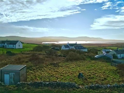 Land for sale in Isle of Islay, PA44 — £135,000 • 1 bed • 1 bath
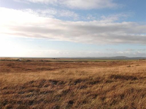 Land for sale in Gariehill Smallholding, Glenmachrie, Port Ellen, Isle Of Islay, PA42 — £245,000 • 1 bed • 1 bath
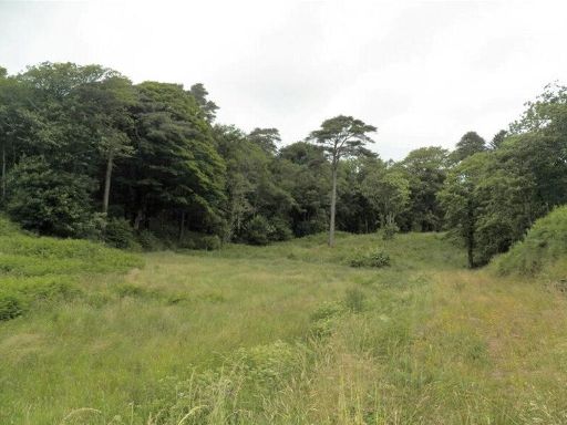 Land for sale in Ballygrant, Isle of Islay, PA45 — £70,000 • 1 bed • 1 bath
 Land for sale in Port Charlotte, PA48 — £100,000 • 1 bed • 1 bath • 11690 ft²
 3 bedroom detached house for sale in Machrie Mill Croft, Kilchoman, Isle Of Islay, Argyll and Bute, PA49 — £325,000 • 3 bed • 1 bath • 887 ft²
Meta
- {
"@context": "https://schema.org",
"@type": "Residence",
"name": "Plot for sale in Mulindry Plot 3A , PA44 7PZ, PA44",
"description": "",
"url": "https://propertypiper.co.uk/property/0298bda1-3ceb-4ec3-8dae-1c23c8e03376",
"image": "https://image-a.propertypiper.co.uk/0e270724-f87c-4ba1-9784-d5f3952dbb21-1024.jpeg",
"address": {
"@type": "PostalAddress",
"streetAddress": "NERIBY FARM, GLEN ROAD",
"postalCode": "PA44 7PZ",
"addressLocality": "Argyll and Bute",
"addressRegion": "Argyll and Bute",
"addressCountry": "Scotland"
},
"geo": {
"@type": "GeoCoordinates",
"latitude": 55.76446902439694,
"longitude": -6.207155543216637
},
"numberOfRooms": 1,
"numberOfBathroomsTotal": 1,
"offers": {
"@type": "Offer",
"price": 80000,
"priceCurrency": "GBP",
"availability": "https://schema.org/InStock"
},
"additionalProperty": [
{
"@type": "PropertyValue",
"name": "Feature",
"value": "land"
},
{
"@type": "PropertyValue",
"name": "Feature",
"value": "plot"
},
{
"@type": "PropertyValue",
"name": "Feature",
"value": "rural"
},
{
"@type": "PropertyValue",
"name": "Feature",
"value": "undeveloped"
},
{
"@type": "PropertyValue",
"name": "Feature",
"value": "open space"
},
{
"@type": "PropertyValue",
"name": "Feature",
"value": "countryside"
},
{
"@type": "PropertyValue",
"name": "Feature",
"value": "potential"
},
{
"@type": "PropertyValue",
"name": "Feature",
"value": "green land"
},
{
"@type": "PropertyValue",
"name": "Feature",
"value": "investment"
},
{
"@type": "PropertyValue",
"name": "Feature",
"value": "plot"
},
{
"@type": "PropertyValue",
"name": "Feature",
"value": "land"
},
{
"@type": "PropertyValue",
"name": "Feature",
"value": "development opportunity"
},
{
"@type": "PropertyValue",
"name": "Feature",
"value": "rural"
},
{
"@type": "PropertyValue",
"name": "Feature",
"value": "greenfield"
},
{
"@type": "PropertyValue",
"name": "Feature",
"value": "investment"
},
{
"@type": "PropertyValue",
"name": "Feature",
"value": "countryside"
},
{
"@type": "PropertyValue",
"name": "Feature",
"value": "open space"
}
]
}