LS11 5ED - 2 bedroom property for sale in Foundry Side, David Street,…
View on Property Piper
2 bedroom property for sale in Foundry Side, David Street, Leeds, LS11
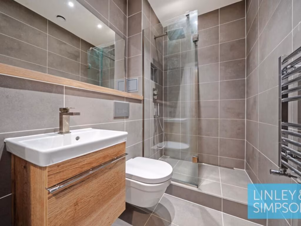
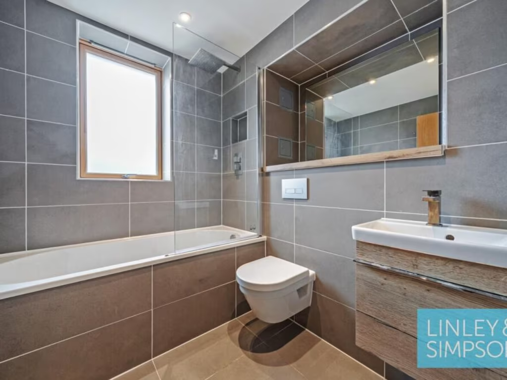
Property Details
- Price: £425000
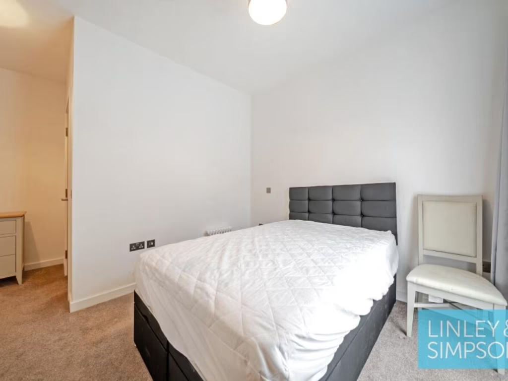
- Bedrooms: 2
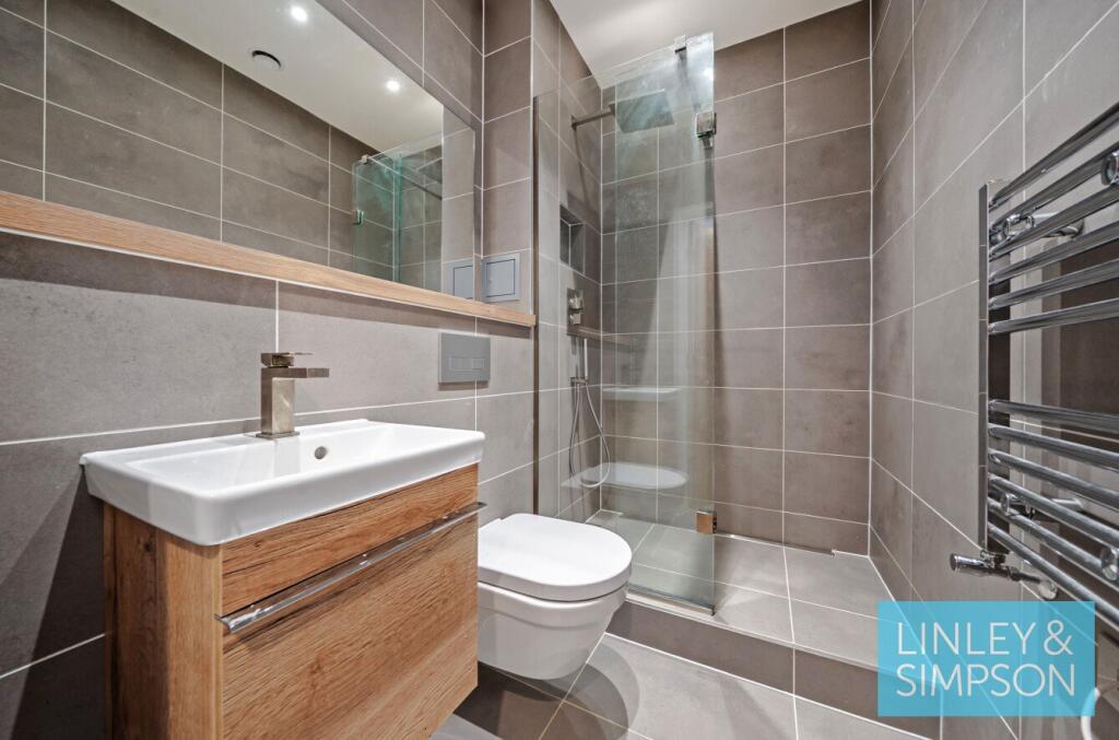
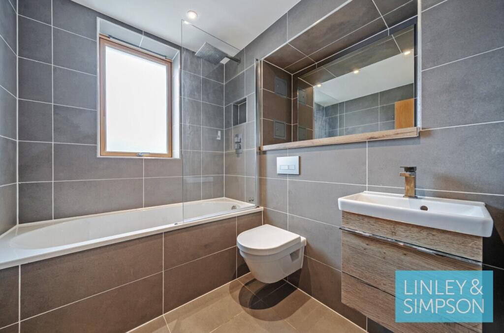
- Bathrooms: 2
- Property Type: undefined
- Property SubType: undefined
Brochure Descriptions
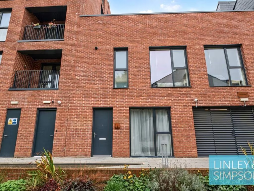
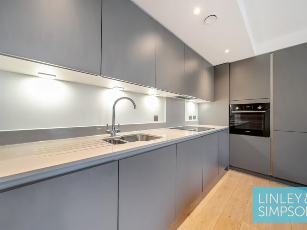
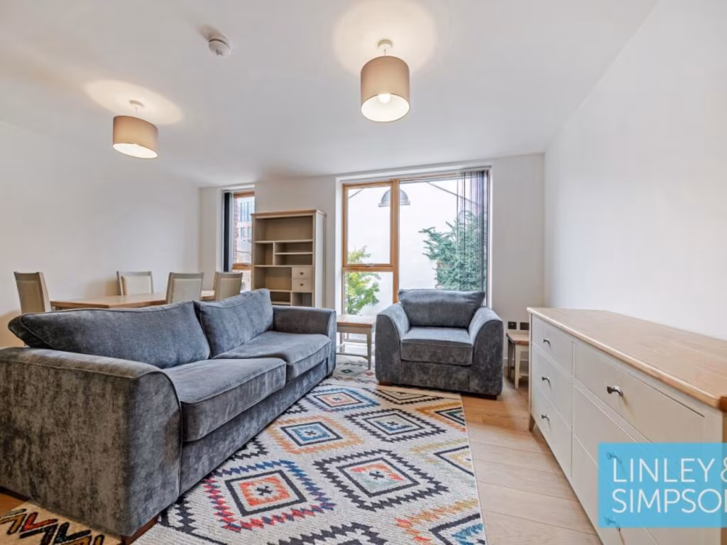
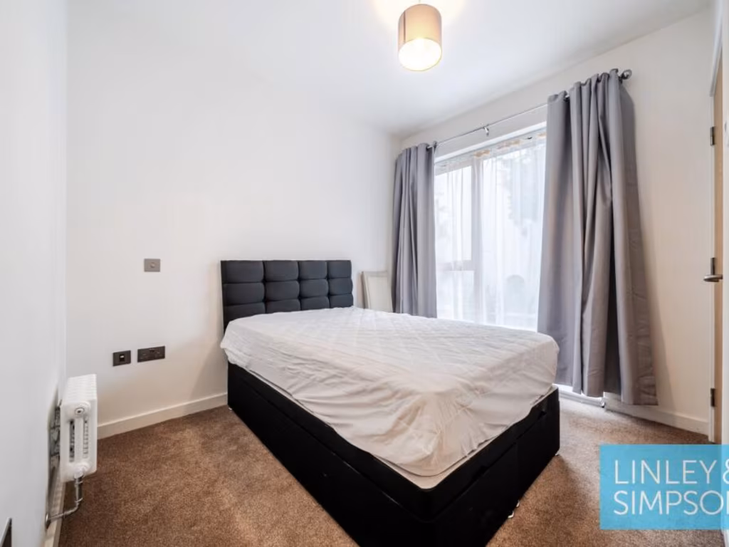
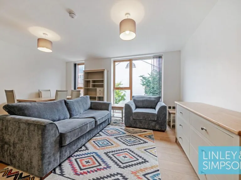
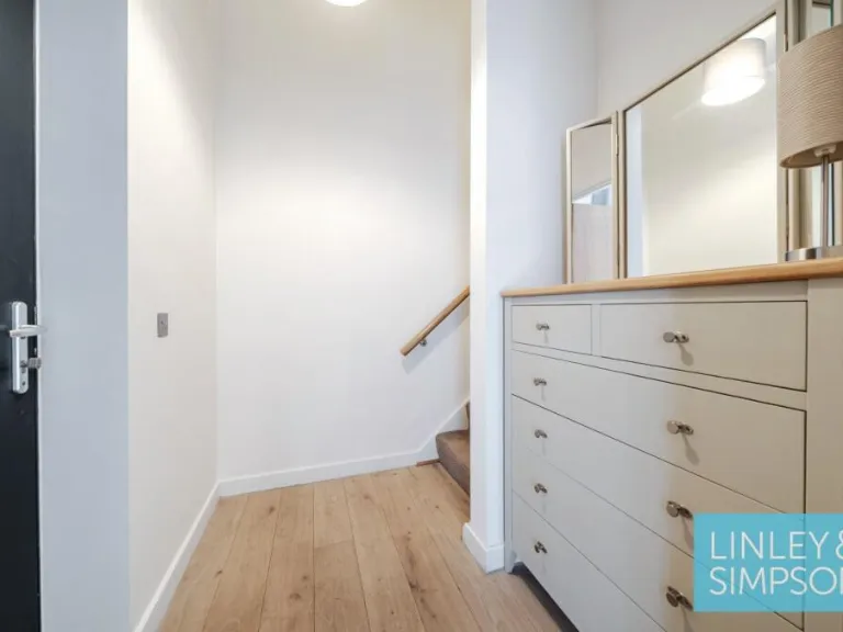
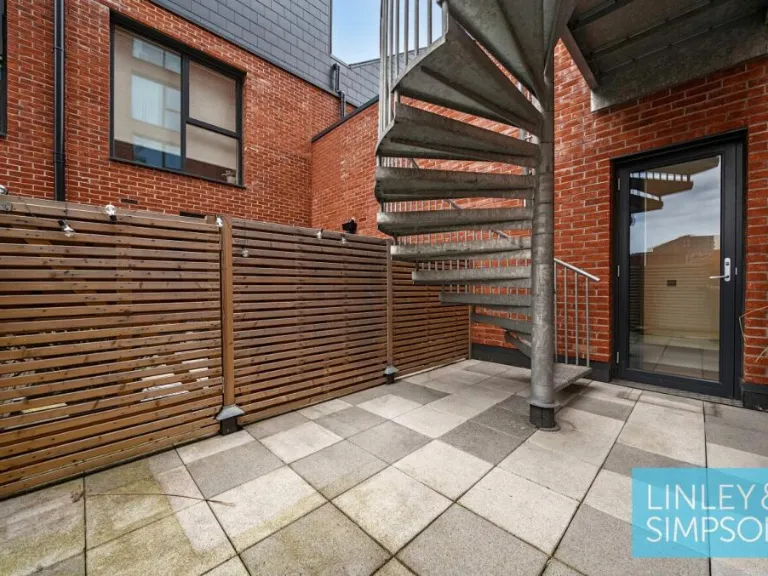
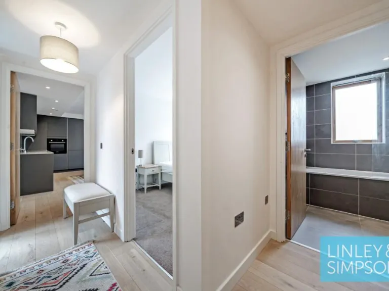
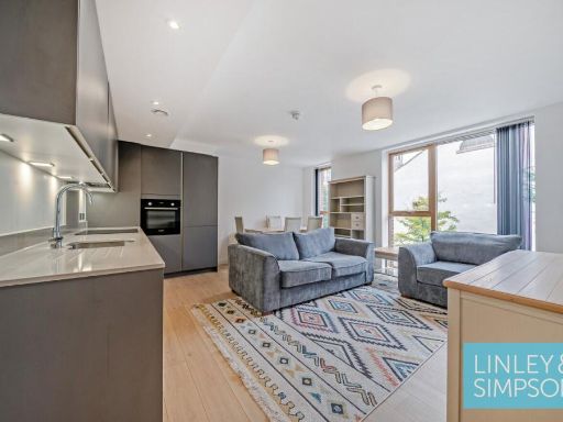
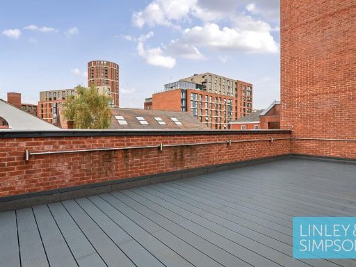
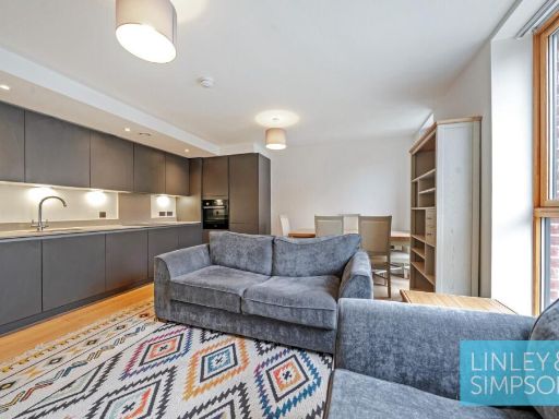
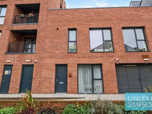
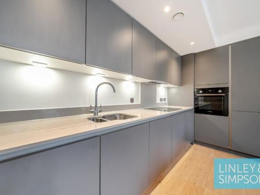
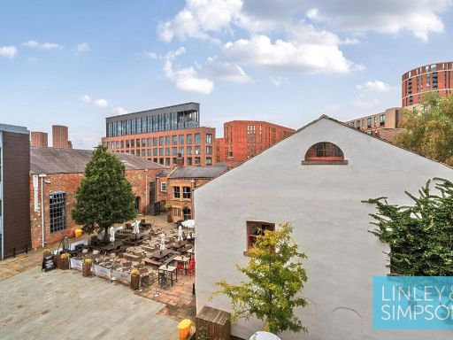
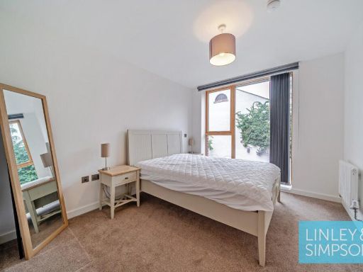
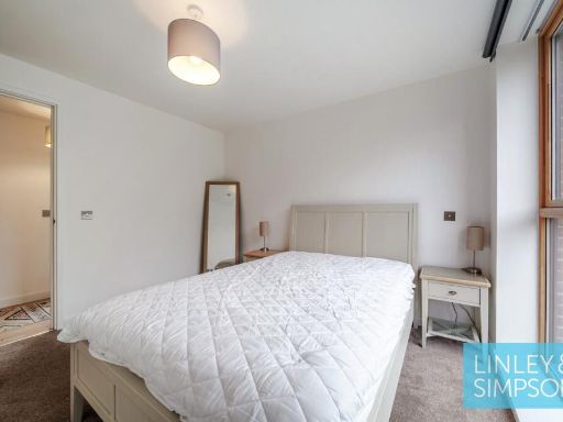
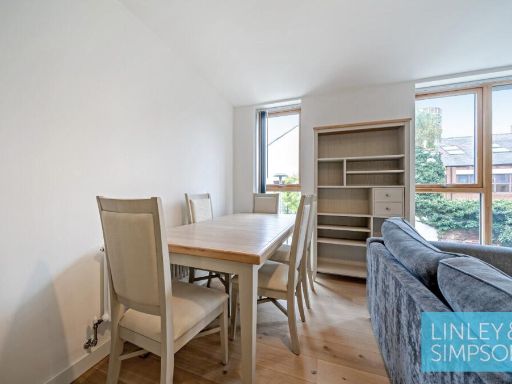
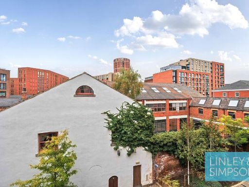
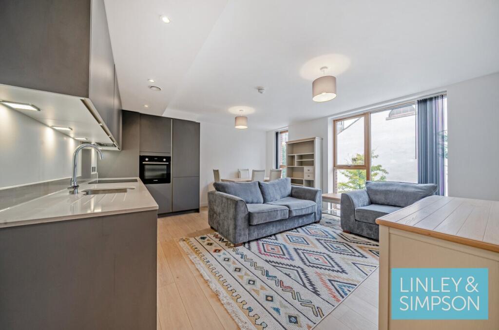
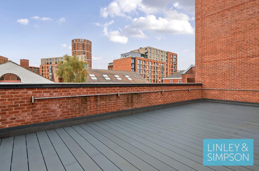
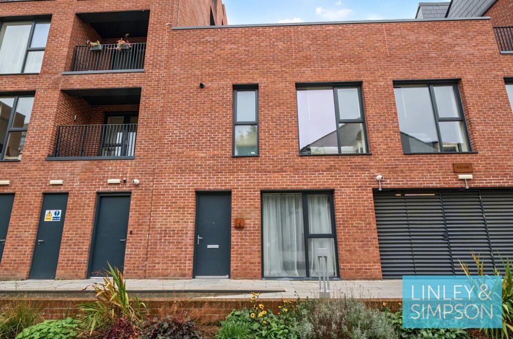
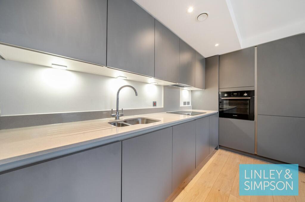
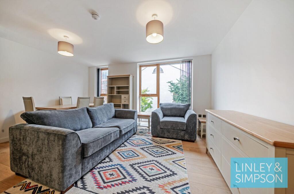
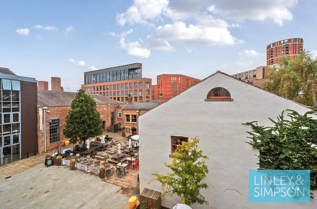
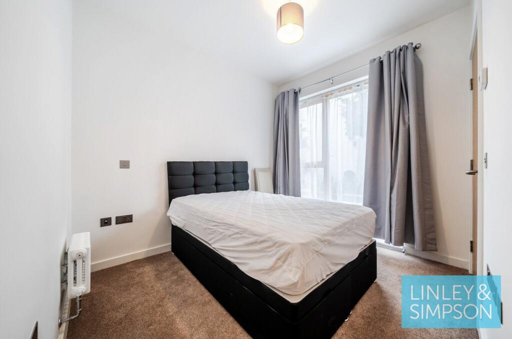
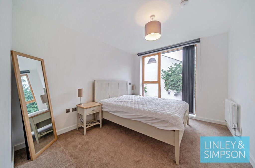
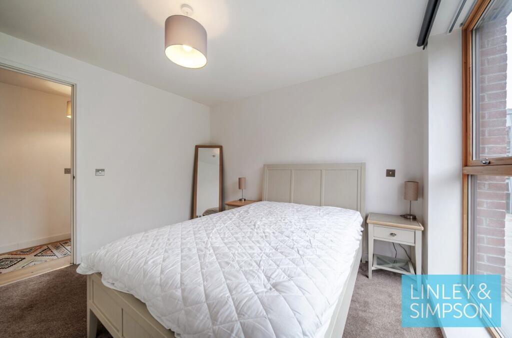
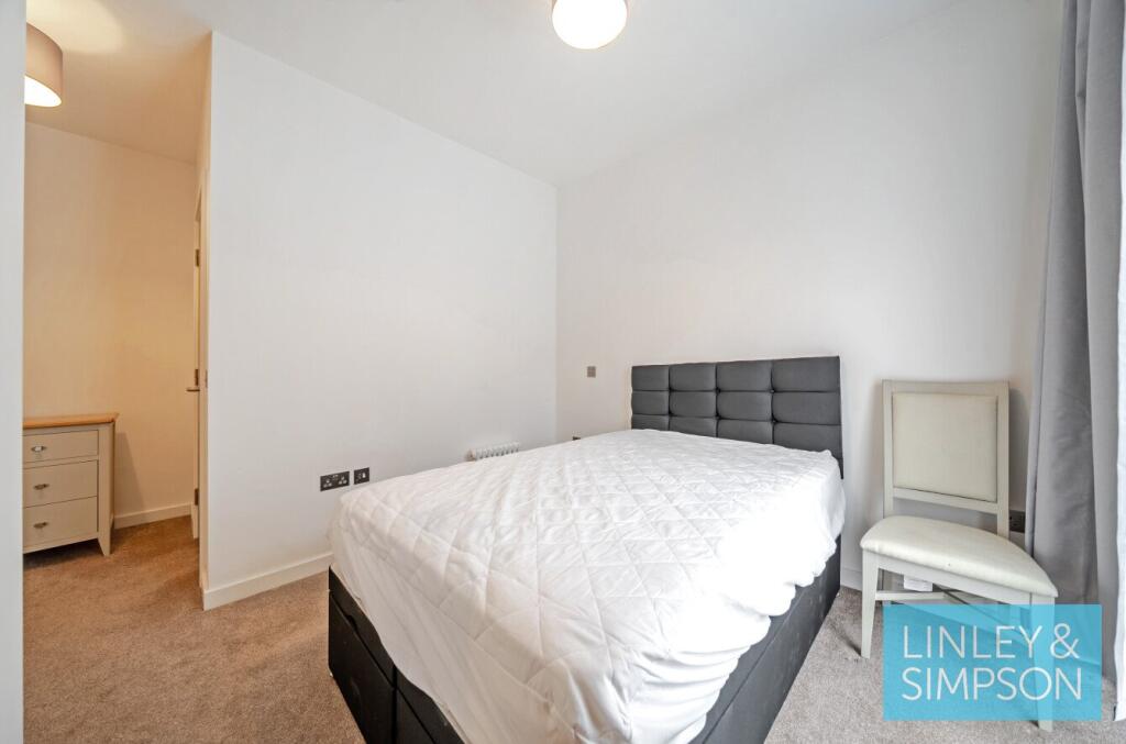
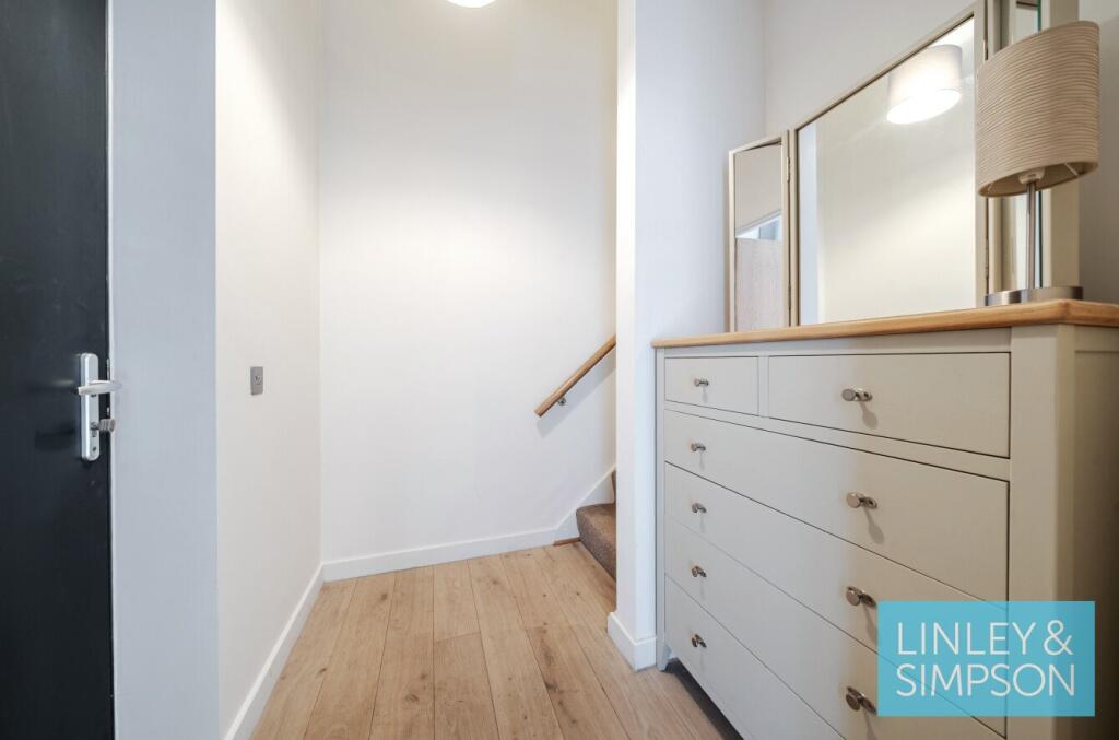
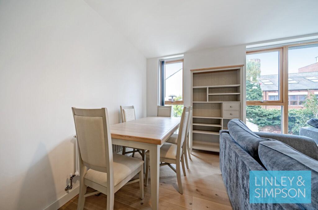
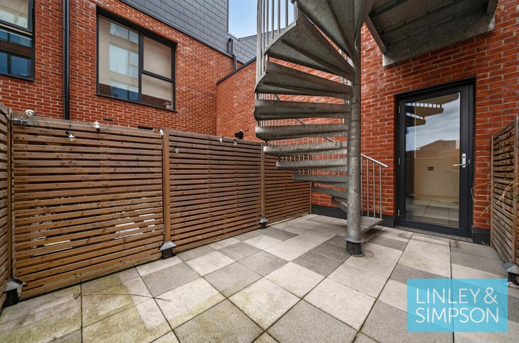
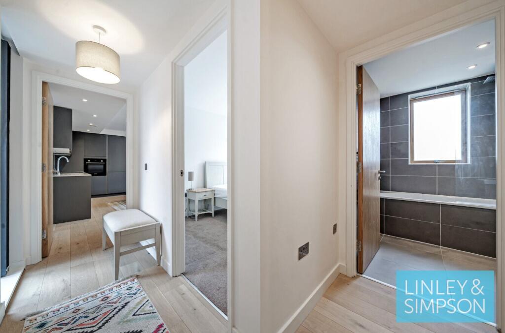
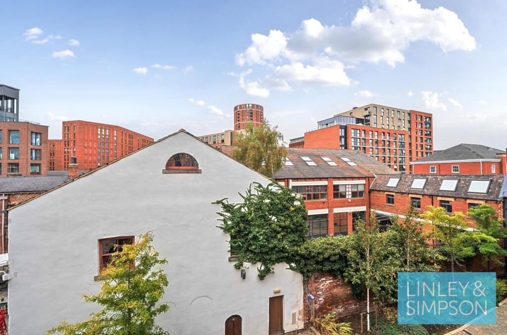
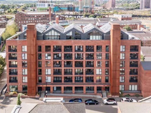
- Contemporary 2-bedroom townhouse presented in a modern open-plan layout. The living/kitchen area is bright with large windows, neutral finishes and integrated kitchen units. Property includes a private terrace with city views (decked area suitable for seating) and allocated parking. Overall accommodation appears compact to average in size for an inner-city townhouse, well-suited to professionals or as an investment; good natural light, modern fixtures, and a practical low-maintenance exterior terrace. EPC rating shown as B.
Image Descriptions
- contemporary open-plan living room and kitchen contemporary
- rooftop terrace modern
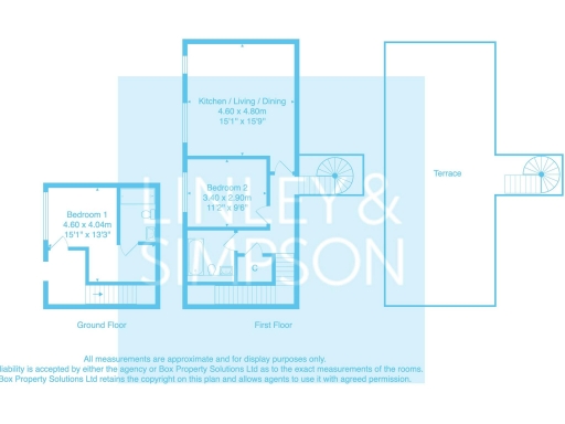
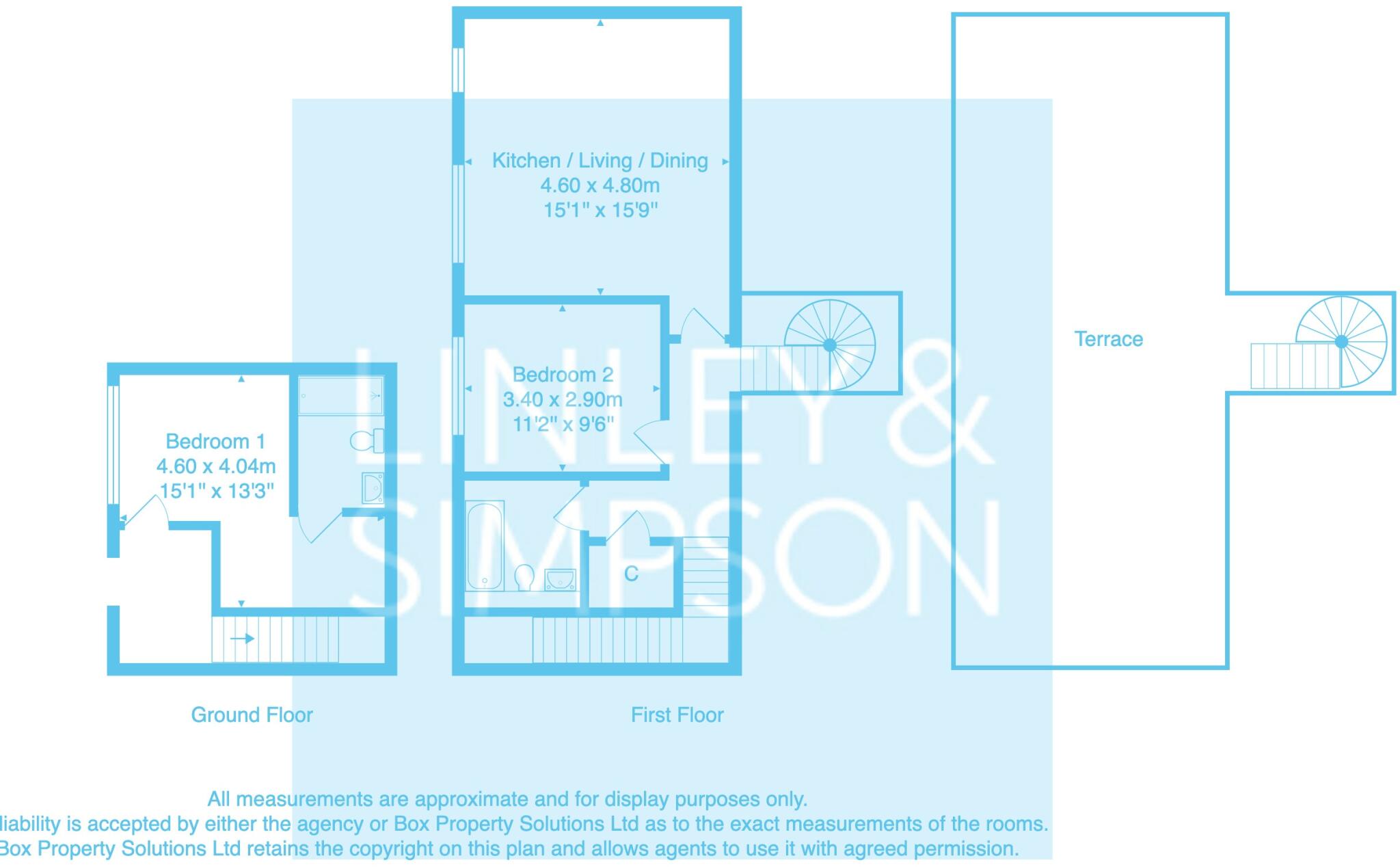
Rooms
- Bedroom 1:
- Kitchen / Living / Dining:
- Bedroom 2:
Textual Property Features
Detected Visual Features
- contemporary design
- open-plan
- living room
- modern kitchen
- large windows
- natural light
- hardwood floors
- modern building
- rooftop terrace
- urban view
- penthouse
- apartment
- city living
EPC Details
- High performance glazing
- Average thermal transmittance 0.14 W/m-¦K
- Boiler and radiators, mains gas
- Low energy lighting in all fixed outlets
- Average thermal transmittance 0.11 W/m-¦K
Nearby Schools
- St Anthony's Catholic Primary School, Beeston
- Beeston Primary School
- St Francis of Assisi Catholic Primary School, a Voluntary Academy
- Beeston Hill St Luke's Church of England Primary School
- Ingram Road Primary School
- University Technical College Leeds
- Dixons Trinity Chapeltown
- Park View Primary Academy
- Castleton Primary School
- Blenheim Primary School
- Quarry Mount Primary School
- Greenmount Primary School
- St Marys Church of England Primary Academy
- New Bewerley Community School
- St Joseph's Catholic Primary School, Hunslet
- LS-TEN
- The Ruth Gorse Academy
- Mount St Mary's Catholic High School
- Rosebank Primary School
- Leeds City Academy
- Hugh Gaitskell Primary School
- Hunslet Moor Primary School
- Lane End Primary School
- Holy Rosary and St Anne's Catholic Primary School, a Voluntary Academy
Nearest General Shops
- Id: 1539223158
- Tags:
- Addr:
- Housename: Aquatite House
- Housenumber: Unit E
- Postcode: LS11 9UD
- Street: Water Lane
- Description: MOT station
- Name: Ian Bentley Fleet Services
- Shop: car_repair
- Website: http://www.ibfs.co.uk/
- TagsNormalized:
- service
- car repair
- repair
- shop
- Lat: 53.7896404
- Lon: -1.5573724
- FullGeoHash: gcwfh81gqedz
- PartitionGeoHash: gcwf
- Images:
- FoodStandards: null
- Distance: 402.9
,- Id: 3994428608
- Tags:
- Name: Pastille
- Shop: beauty
- TagsNormalized:
- Lat: 53.7935194
- Lon: -1.5486025
- FullGeoHash: gcwfhbb3fyy6
- PartitionGeoHash: gcwf
- Images:
- FoodStandards: null
- Distance: 348.6
,- Id: 8657813369
- Tags:
- Name: Jet 2
- Shop: travel_agency
- TagsNormalized:
- Lat: 53.7888621
- Lon: -1.5500561
- FullGeoHash: gcwcuxzqc4dk
- PartitionGeoHash: gcwc
- Images:
- FoodStandards: null
- Distance: 255.5
}
Nearest Religious buildings
- Id: 154960871
- Tags:
- Amenity: place_of_worship
- Building: yes
- Denomination: anglican
- Name: Holy Trinity Church
- Religion: christian
- Wikidata: Q15224720
- TagsNormalized:
- place of worship
- anglican
- church
- christian
- Lat: 53.796172
- Lon: -1.5435883
- FullGeoHash: gcwfhc7crv31
- PartitionGeoHash: gcwf
- Images:
- FoodStandards: null
- Distance: 785.7
,- Id: 2104911034
- Tags:
- Addr:
- Housenumber: 31
- Postcode: LS1 2JG
- Street: St Paul's Street
- Amenity: place_of_worship
- Denomination: tibetan
- Level: 1
- Name: Jamyang
- Religion: buddhist
- Website: http://www.jamyangleeds.co.uk/
- TagsNormalized:
- place of worship
- buddhist
- buddhist temple
- temple
- Lat: 53.7979479
- Lon: -1.551275
- FullGeoHash: gcwfh9w7u8me
- PartitionGeoHash: gcwf
- Images:
- FoodStandards: null
- Distance: 777.9
,- Id: 78423923
- Tags:
- Amenity: place_of_worship
- Building: church
- Denomination: unitarian
- Name: Mill Hill Unitarian Chapel
- Religion: christian
- Source: OS OpenData StreetView / local knowledge
- Wikidata: Q15253403
- Wikipedia: en:Mill Hill Chapel
- TagsNormalized:
- place of worship
- church
- unitarian
- chapel
- christian
- Lat: 53.7967006
- Lon: -1.5465875
- FullGeoHash: gcwfhc3u3zug
- PartitionGeoHash: gcwf
- Images:
- FoodStandards: null
- Distance: 720.4
}
Nearest Medical buildings
- Id: 2138746310
- Tags:
- Amenity: doctors
- Healthcare: doctor
- Name: West Point Practice
- TagsNormalized:
- doctor
- doctors
- health
- healthcare
- Lat: 53.7959639
- Lon: -1.5533297
- FullGeoHash: gcwfh9kbhy92
- PartitionGeoHash: gcwf
- Images:
- FoodStandards: null
- Distance: 567.6
,- Id: 10106730989
- Tags:
- Amenity: clinic
- Healthcare: clinic
- Name: The Whitehall Clinic
- TagsNormalized:
- Lat: 53.7953146
- Lon: -1.5545382
- FullGeoHash: gcwfh9hh2tkr
- PartitionGeoHash: gcwf
- Images:
- FoodStandards: null
- Distance: 520.3
,- Id: 203446514
- Tags:
- Amenity: doctors
- Building: yes
- Healthcare: doctor
- Height: 6
- Name: This is my healthcare
- TagsNormalized:
- doctor
- doctors
- health
- healthcare
- Lat: 53.7917058
- Lon: -1.550669
- FullGeoHash: gcwfh8qz6u9r
- PartitionGeoHash: gcwf
- Images:
- FoodStandards: null
- Distance: 105.7
,- Id: 6060467944
- Tags:
- Addr:
- City: Leeds
- Housename: Leodis Court
- Postcode: LS11 5JJ
- Street: David Street
- Unit: 3
- Amenity: pharmacy
- Healthcare: pharmacy
- Name: Living Care Deliveries Leeds
- TagsNormalized:
- Lat: 53.7905478
- Lon: -1.5518859
- FullGeoHash: gcwfh8mbwkyh
- PartitionGeoHash: gcwf
- Images:
- FoodStandards: null
- Distance: 47.8
}
Nearest Airports
- Id: 11519546
- Tags:
- Addr:
- City: Leeds
- Postcode: LS19 7TU
- Aerodrome: international
- Aerodrome:type: public
- Aeroway: aerodrome
- Iata: LBA
- Icao: EGNM
- Name: Leeds Bradford Airport
- Operator: Leeds Bradford Airport Limited
- Operator:type: private
- Ref: LBA
- Type: multipolygon
- Website: https://www.leedsbradfordairport.co.uk/
- Wikidata: Q8699
- Wikipedia: en:Leeds Bradford Airport
- TagsNormalized:
- airport
- international airport
- Lat: 53.8667047
- Lon: -1.660138
- FullGeoHash: gcwf6nph7cx3
- PartitionGeoHash: gcwf
- Images:
- Q8699-1
- Q8699-2
- Q8699-3
- Q8699-4
- FoodStandards: null
- Distance: 11028.5
}
Nearest Leisure Facilities
- Id: 878874971
- Tags:
- TagsNormalized:
- Lat: 53.7949389
- Lon: -1.5543894
- FullGeoHash: gcwfh9h4hp7q
- PartitionGeoHash: gcwf
- Images:
- FoodStandards: null
- Distance: 477.9
,- Id: 6683253577
- Tags:
- TagsNormalized:
- Lat: 53.7932049
- Lon: -1.5501586
- FullGeoHash: gcwfh8z0nsjy
- PartitionGeoHash: gcwf
- Images:
- FoodStandards: null
- Distance: 268.8
,- Id: 8731481807
- Tags:
- Addr:
- City: Leeds
- Housename: Bridgewater Place
- Postcode: LS11 5BZ
- Street: Water Lane
- Brand: Anytime Fitness
- Brand:wikidata: Q4778364
- Brand:wikipedia: en:Anytime Fitness
- Leisure: fitness_centre
- Name: Anytime Fitness
- TagsNormalized:
- anytime fitness
- fitness
- fitness centre
- leisure
- Lat: 53.7920026
- Lon: -1.5480406
- FullGeoHash: gcwfhb8c0h16
- PartitionGeoHash: gcwf
- Images:
- FoodStandards: null
- Distance: 264.6
,- Id: 203587708
- Tags:
- TagsNormalized:
- Lat: 53.7916127
- Lon: -1.5536264
- FullGeoHash: gcwfh8kwvgkh
- PartitionGeoHash: gcwf
- Images:
- FoodStandards: null
- Distance: 148.5
,- Id: 203587430
- Tags:
- TagsNormalized:
- Lat: 53.7913305
- Lon: -1.5517303
- FullGeoHash: gcwfh8qj4nf1
- PartitionGeoHash: gcwf
- Images:
- FoodStandards: null
- Distance: 41.9
}
Nearest Tourist attractions
- Id: 977037263
- Tags:
- Addr:
- City: Leeds
- Street: Kidacre Park
- Building: yes
- Tourism: apartment
- TagsNormalized:
- Lat: 53.7871775
- Lon: -1.5423512
- FullGeoHash: gcwcuzsvh8ee
- PartitionGeoHash: gcwc
- Images:
- FoodStandards: null
- Distance: 741.8
,- Id: 977037264
- Tags:
- Addr:
- City: Leeds
- Street: Kidacre Park
- Building: yes
- Tourism: apartment
- TagsNormalized:
- Lat: 53.7871611
- Lon: -1.5425349
- FullGeoHash: gcwcuzsubmd9
- PartitionGeoHash: gcwc
- Images:
- FoodStandards: null
- Distance: 732.9
,- Id: 977037265
- Tags:
- Addr:
- City: Leeds
- Street: Kidacre Park
- Building: yes
- Tourism: apartment
- TagsNormalized:
- Lat: 53.7871401
- Lon: -1.5427745
- FullGeoHash: gcwcuzssf9xu
- PartitionGeoHash: gcwc
- Images:
- FoodStandards: null
- Distance: 721.5
}
Nearest Train stations
- Id: 207388316
- Tags:
- Name: Cottingley
- Naptan:
- Network: National Rail
- Public_transport: station
- Railway: station
- Ref:
- Source: gpx
- Wikidata: Q3033284
- Wikipedia: en:Cottingley railway station
- TagsNormalized:
- Lat: 53.7680337
- Lon: -1.5877727
- FullGeoHash: gcwcgu5v6pyy
- PartitionGeoHash: gcwc
- Images:
- FoodStandards: null
- Distance: 3482.4
,- Id: 388094272
- Tags:
- Name: Park Halt
- Network: Middleton Railway
- Operator: The Middleton Railway Trust
- Public_transport: station
- Railway: station
- Source:
- Train: yes
- Usage: tourism
- Wikidata: Q7137761
- Wikipedia: en:Park Halt railway station
- TagsNormalized:
- Lat: 53.7614562
- Lon: -1.5363956
- FullGeoHash: gcwcv4cppmu6
- PartitionGeoHash: gcwc
- Images:
- FoodStandards: null
- Distance: 3430.1
,- Id: 21468573
- Tags:
- Name: Burley Park
- Naptan:
- Network: National Rail
- Platforms: 2
- Public_transport: station
- Railway: station
- Ref:
- Wikidata: Q3298380
- Wikipedia: en:Burley Park railway station
- TagsNormalized:
- Lat: 53.8121567
- Lon: -1.5779212
- FullGeoHash: gcwfhh4yxc0d
- PartitionGeoHash: gcwf
- Images:
- FoodStandards: null
- Distance: 2921
,- Id: 3089365411
- Tags:
- Name: Moor Road
- Network: Middleton Railway
- Operator: The Middleton Railway Trust
- Public_transport: station
- Railway: station
- Train: yes
- Usage: tourism
- Wikidata: Q6908054
- Wikipedia: en:Moor Road railway station
- TagsNormalized:
- Lat: 53.7738227
- Lon: -1.5389272
- FullGeoHash: gcwcuvprhrhe
- PartitionGeoHash: gcwc
- Images:
- FoodStandards: null
- Distance: 2080.6
,- Id: 7156706693
- Tags:
- Alt_name: Leeds City
- Name: Leeds
- Naptan:
- Network: National Rail
- Operator: Network Rail
- Platforms: 17
- Public_transport: station
- Railway: station
- Ref:
- Train: yes
- Wheelchair: yes
- Wikidata: Q1466941
- Wikipedia: en:Leeds railway station
- TagsNormalized:
- Lat: 53.794414
- Lon: -1.548621
- FullGeoHash: gcwfhbbr4t86
- PartitionGeoHash: gcwf
- Images:
- FoodStandards: null
- Distance: 433.2
}
Nearest Hotels
- Id: 203560468
- Tags:
- Addr:
- City: Leeds
- Housenumber: 7
- Postcode: LS11 9AT
- Street: City Walk
- Brand: Bewleys Hotels
- Building: yes
- Fhrs:
- Name: Clayton Hotel
- Tourism: hotel
- Website: https://www.claytonhotelleeds.com/
- Wheelchair: yes
- Wikidata: Q56085020
- TagsNormalized:
- Lat: 53.7884454
- Lon: -1.5466798
- FullGeoHash: gcwcuzcsrszy
- PartitionGeoHash: gcwc
- Images:
- FoodStandards: null
- Distance: 430
,- Id: 127874630
- Tags:
- Addr:
- City: Leeds
- Country: GB
- Postcode: LS1 4BX
- Street: Neville Street
- Brand: Hilton
- Brand:wikidata: Q598884
- Brand:wikipedia: en:Hilton Hotels & Resorts
- Building: yes
- Contact:
- Facebook: https://www.facebook.com/HiltonLeedsCity
- Instagram: https://www.instagram.com/hiltonleedscity
- Linkedin: https://www.linkedin.com/company/hilton-leeds-city
- Twitter: https://twitter.com/HiltonLeedsCity
- Email: reservations.Leedscity@Hilton.com
- Fax: +44 113 2207702
- Fhrs:
- Internet_access: wlan
- Internet_access:fee: yes
- Name: Hilton Leeds City
- Operator: Hilton
- Phone: +44 113 2442000
- Rooms: 208
- Smoking: isolated
- Stars: 4
- Tourism: hotel
- Website: https://www.hilton.com/en/hotels/leehnhn-hilton-leeds-city/
- Wheelchair: yes
- TagsNormalized:
- Lat: 53.7936754
- Lon: -1.5473428
- FullGeoHash: gcwfhbc6b7ct
- PartitionGeoHash: gcwf
- Images:
- FoodStandards: null
- Distance: 414.5
,- Id: 28941248
- Tags:
- Addr:
- City: Leeds
- Housenumber: 2
- Postcode: LS1 4GS
- Street: Wharf Approach
- Brand: DoubleTree
- Brand:wikidata: Q2504643
- Brand:wikipedia: en:DoubleTree
- Building: yes
- Contact:
- Facebook: https://www.facebook.com/DoubletreeLeeds?fref=ts
- Instagram: http://instagram.com/doubletreeleeds
- Linkedin: https://www.linkedin.com/company/doubletree-by-hilton-leeds/
- Twitter: https://twitter.com/doubletreeleeds
- Email: leedsgranarywharf.info@hilton.com
- Fax: +44 113 322 0441
- Fhrs:
- Name: DoubleTree by Hilton Leeds City Centre
- Official_name: DoubleTree by Hilton
- Operator: Hilton
- Phone: +44 113 241 1000
- Rooms: 333
- Smoking: no
- Stars: 4
- Tourism: hotel
- Website: https://www.hilton.com/en/hotels/lbaccdi-doubletree-leeds-city-centre/
- Wheelchair: yes
- Wikidata: Q37858682
- TagsNormalized:
- Lat: 53.7933504
- Lon: -1.5496214
- FullGeoHash: gcwfh8z8gpqd
- PartitionGeoHash: gcwf
- Images:
- FoodStandards: null
- Distance: 298
}
Tags
- contemporary design
- open-plan
- living room
- modern kitchen
- large windows
- natural light
- hardwood floors
- modern building
- rooftop terrace
- urban view
- penthouse
- apartment
- city living
Local Market Stats
- Average Price/sqft: £157
- Avg Income: £32900
- Rental Yield: 6.8%
- Social Housing: 27%
- Planning Success Rate: 85%
AirBnB Data
- 1km average: £121/night
- Listings in 1km: 36
Similar Properties
 2 bedroom apartment for sale in Iron Works, David Street, Leeds, LS11 — £350,000 • 2 bed • 2 bath • 689 ft²
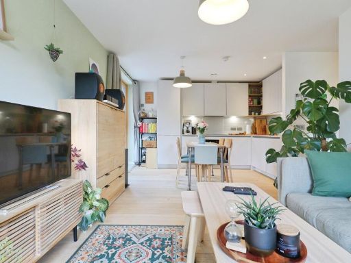 2 bedroom flat for sale in David Street, LEEDS, West Yorkshire, LS11 — £350,000 • 2 bed • 2 bath • 629 ft²
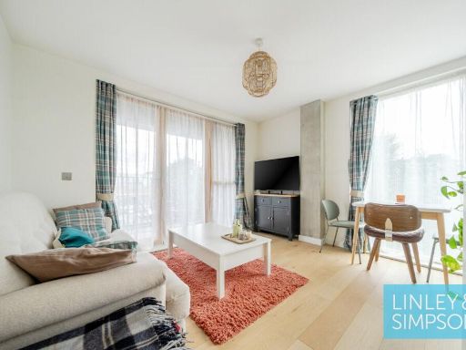 1 bedroom flat for sale in Ironworks, David Street, Leeds, LS11 — £200,000 • 1 bed • 1 bath • 473 ft²
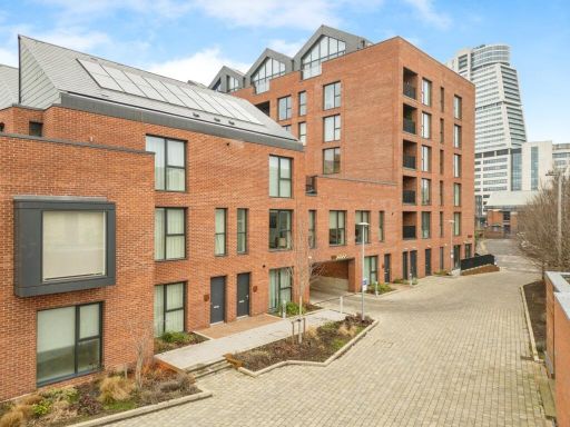 2 bedroom flat for sale in David Street, Leeds, LS11 — £335,000 • 2 bed • 2 bath • 699 ft²
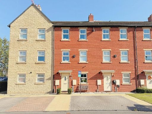 3 bedroom terraced house for sale in Holts Crest Way, Leeds, LS12 — £375,000 • 3 bed • 2 bath • 1152 ft²
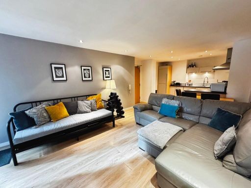 2 bedroom apartment for sale in Faroe, City Island, LS12 — £195,000 • 2 bed • 1 bath • 710 ft²
Meta
- {
"@context": "https://schema.org",
"@type": "Residence",
"name": "2 bedroom property for sale in Foundry Side, David Street,…",
"description": "",
"url": "https://propertypiper.co.uk/property/f6350884-08fb-4c36-bbb6-ce361e318058",
"image": "https://image-a.propertypiper.co.uk/e4b98c8e-274a-41a6-bd20-8f7cc75baeba-1024.jpeg",
"address": {
"@type": "PostalAddress",
"streetAddress": "Foundry Side, David Street, Leeds, LS11",
"postalCode": "LS11 5ED",
"addressLocality": "Leeds",
"addressRegion": "Leeds Central",
"addressCountry": "England"
},
"geo": {
"@type": "GeoCoordinates",
"latitude": 53.790955824486254,
"longitude": -1.5516580268306317
},
"numberOfRooms": 2,
"numberOfBathroomsTotal": 2,
"floorSize": {
"@type": "QuantitativeValue",
"value": 786,
"unitCode": "FTK"
},
"offers": {
"@type": "Offer",
"price": 425000,
"priceCurrency": "GBP",
"availability": "https://schema.org/InStock"
},
"additionalProperty": [
{
"@type": "PropertyValue",
"name": "Feature",
"value": "contemporary design"
},
{
"@type": "PropertyValue",
"name": "Feature",
"value": "open-plan"
},
{
"@type": "PropertyValue",
"name": "Feature",
"value": "living room"
},
{
"@type": "PropertyValue",
"name": "Feature",
"value": "modern kitchen"
},
{
"@type": "PropertyValue",
"name": "Feature",
"value": "large windows"
},
{
"@type": "PropertyValue",
"name": "Feature",
"value": "natural light"
},
{
"@type": "PropertyValue",
"name": "Feature",
"value": "hardwood floors"
},
{
"@type": "PropertyValue",
"name": "Feature",
"value": "modern building"
},
{
"@type": "PropertyValue",
"name": "Feature",
"value": "rooftop terrace"
},
{
"@type": "PropertyValue",
"name": "Feature",
"value": "urban view"
},
{
"@type": "PropertyValue",
"name": "Feature",
"value": "penthouse"
},
{
"@type": "PropertyValue",
"name": "Feature",
"value": "apartment"
},
{
"@type": "PropertyValue",
"name": "Feature",
"value": "city living"
}
]
}
High Res Floorplan Images
Compatible Floorplan Images
FloorplanImages Thumbnail