BS22 6SN - 2 bedroom semidetached bungalow for sale in Elderberry Walk…
View on Property Piper
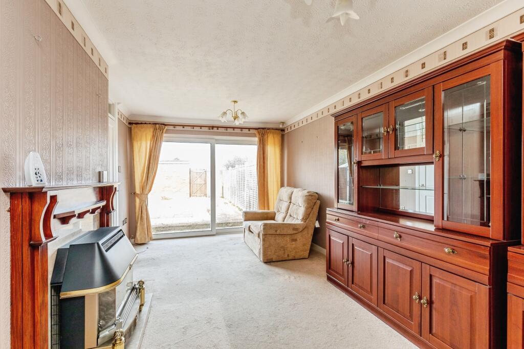
2 bedroom semi-detached bungalow for sale in Elderberry Walk, Weston-super-mare, BS22
Property Details
- Price: £240000
- Bedrooms: 2
- Bathrooms: 1
- Property Type: undefined
- Property SubType: undefined
Image Descriptions
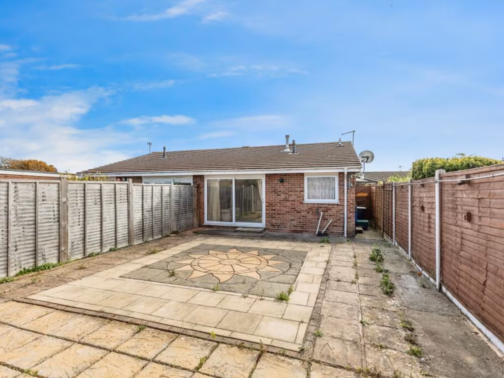
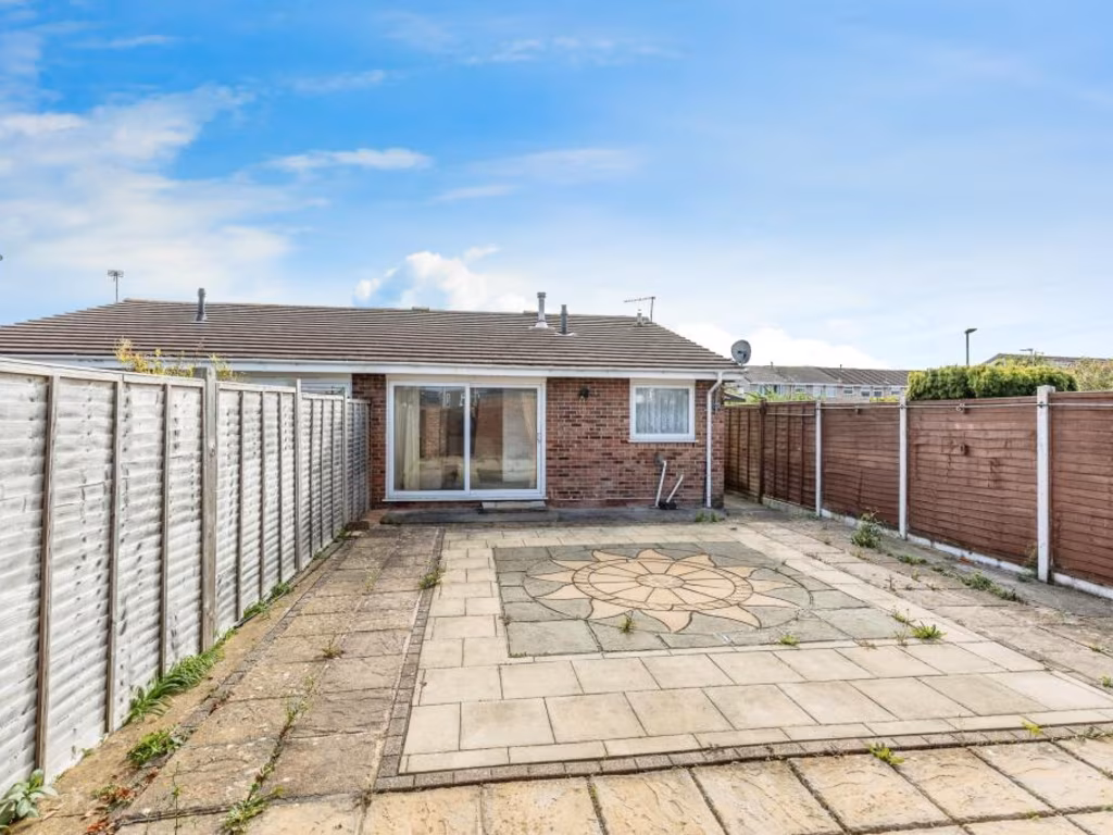
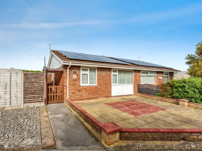
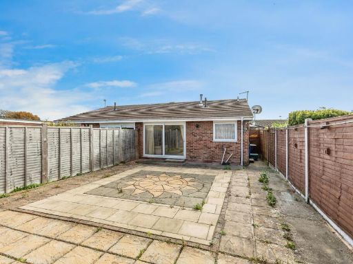
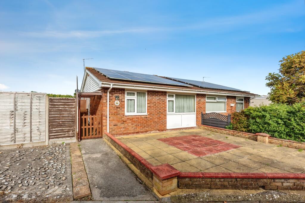
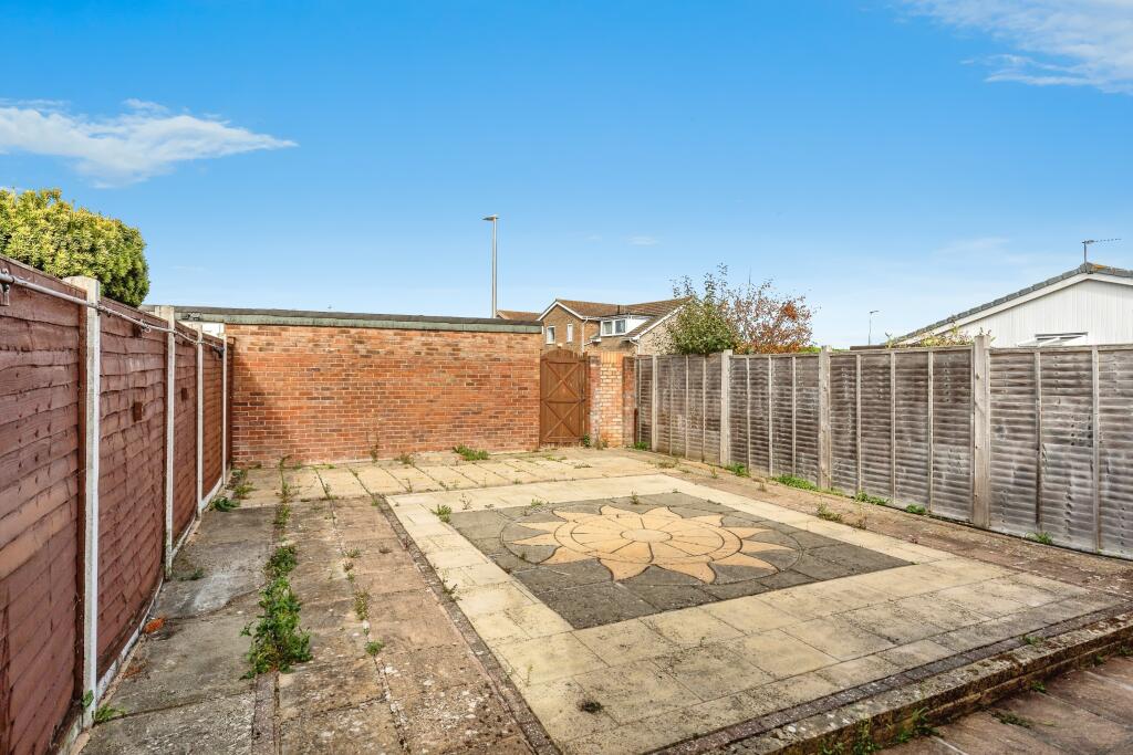
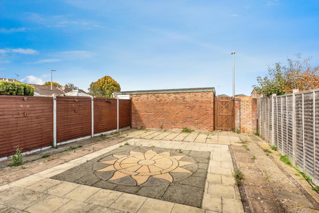
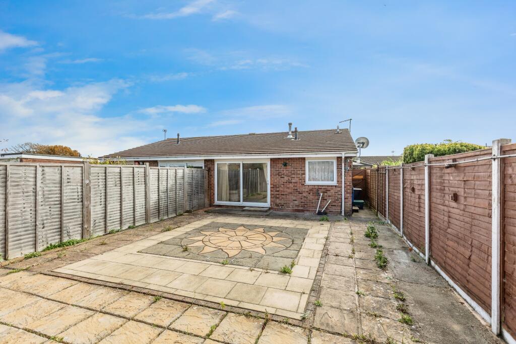
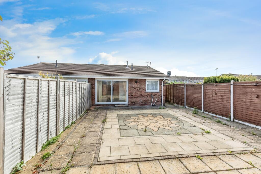
- single-story residential property mid-20th century suburban
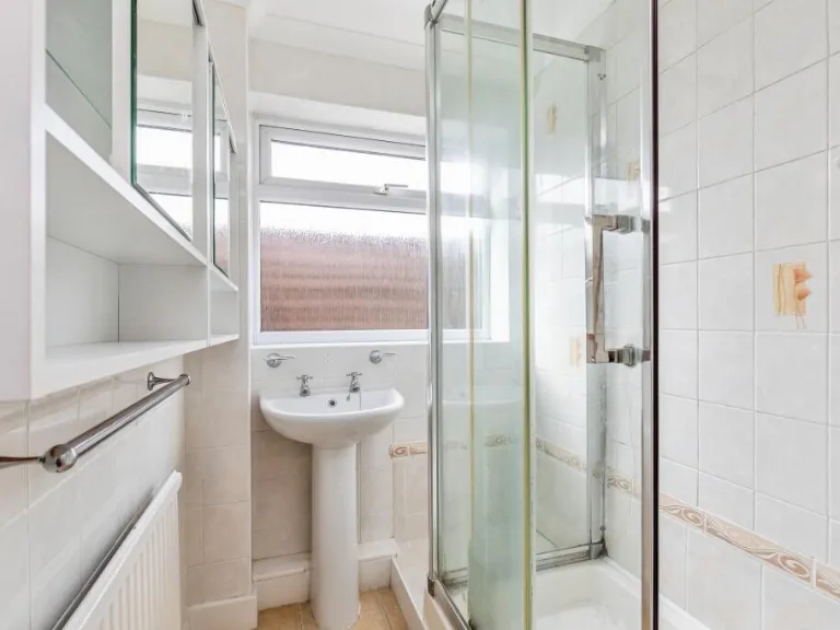
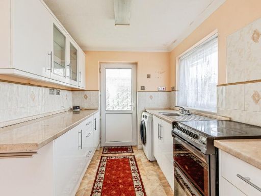
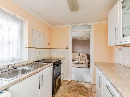
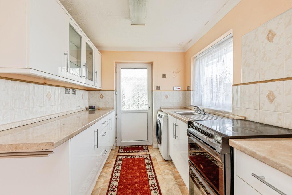
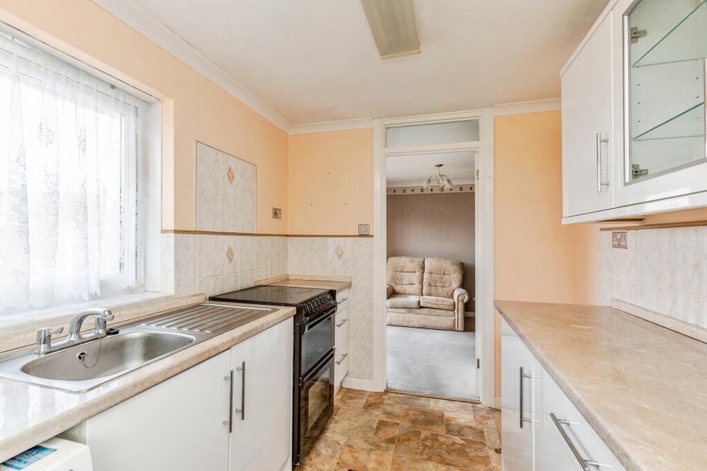
- kitchen mid-20th century
Floorplan Description
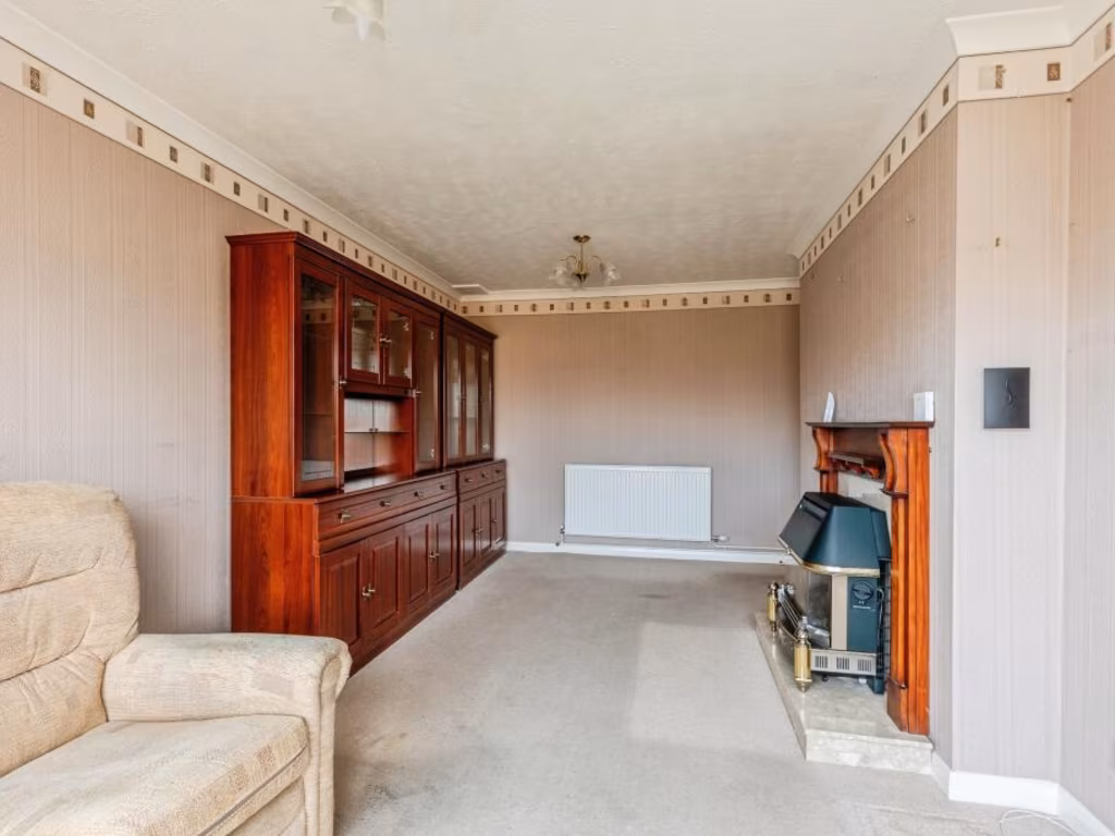
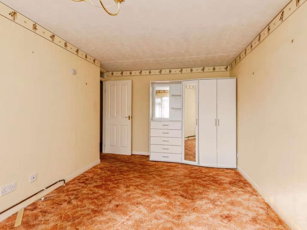
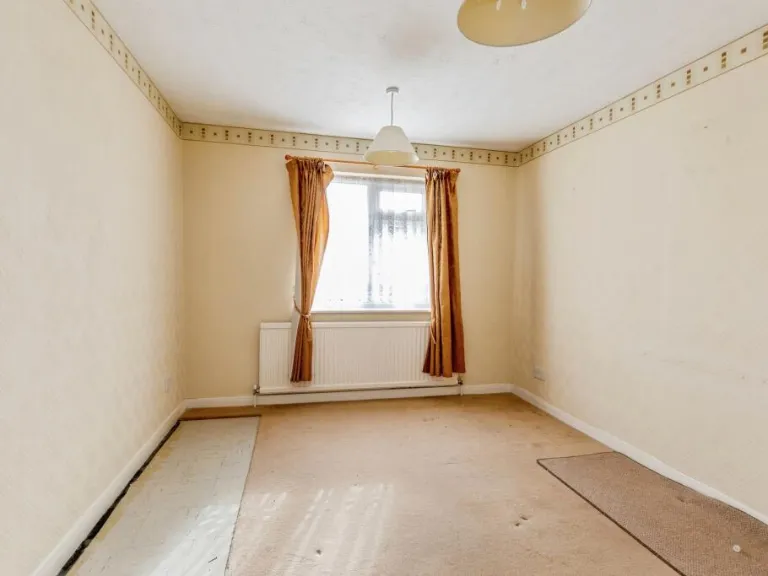
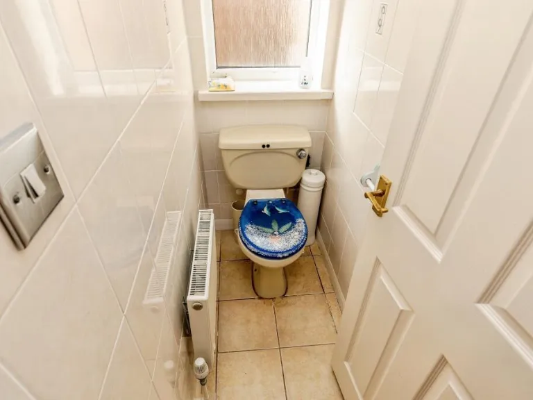
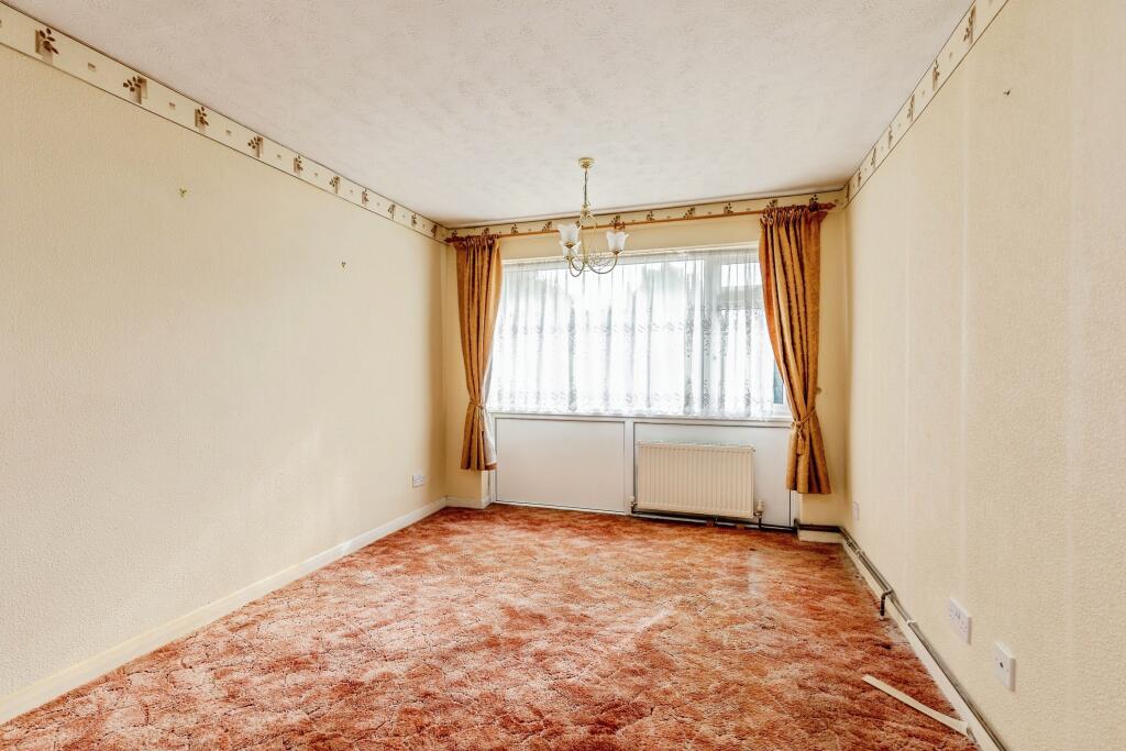
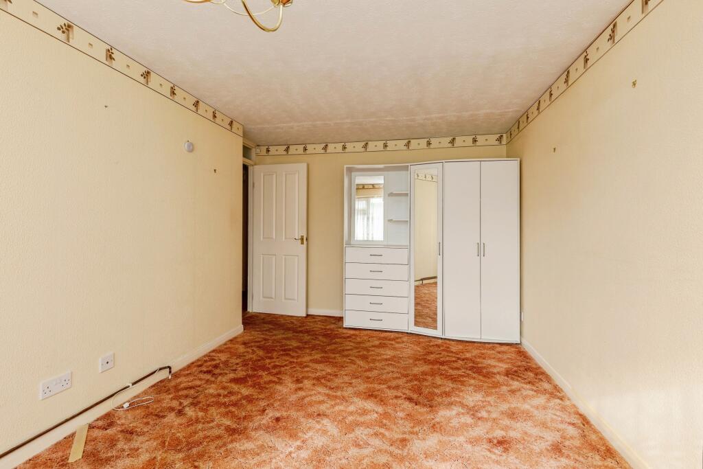
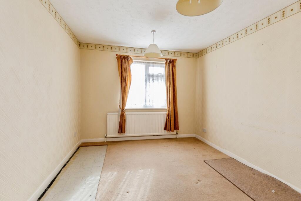
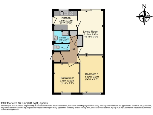
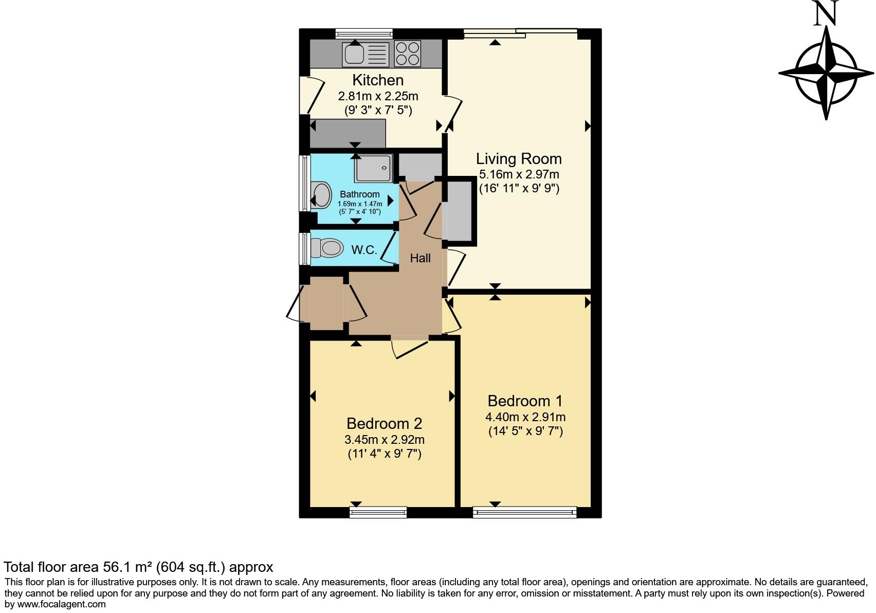
- Single-floor residential flat with kitchen, living room, two bedrooms, bathroom and separate W.C.
Rooms
- Kitchen:
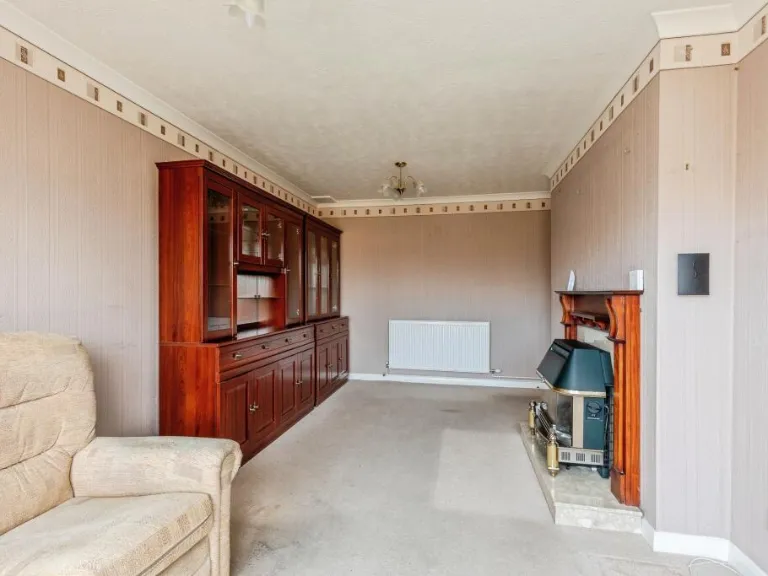
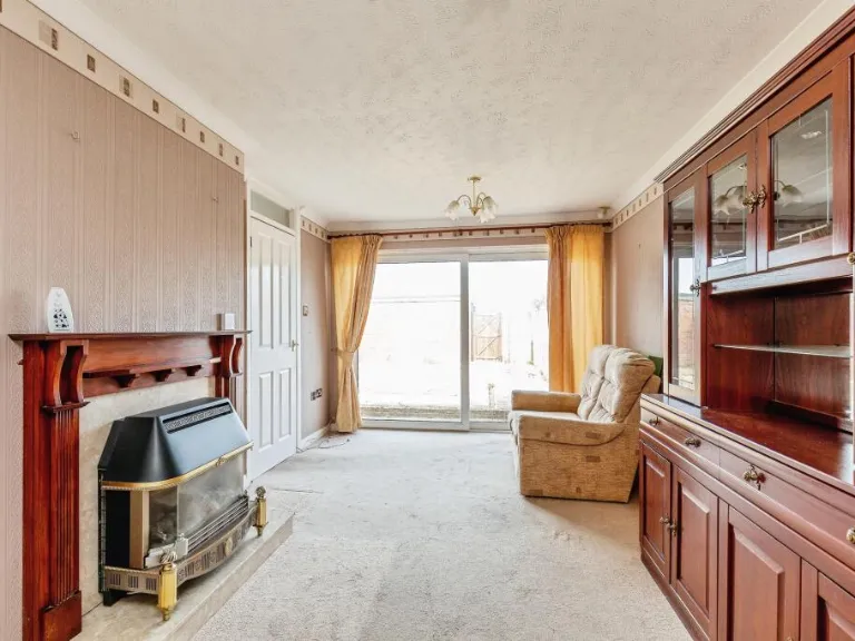
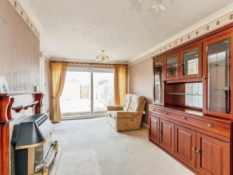
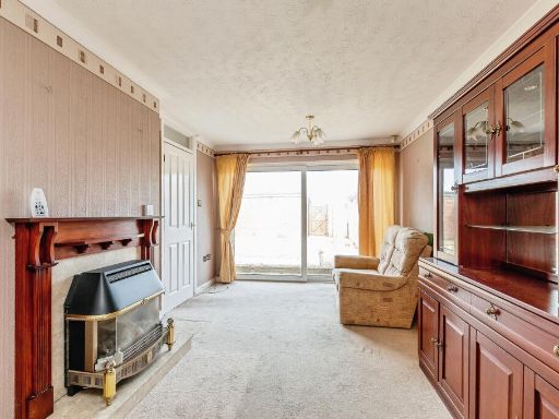
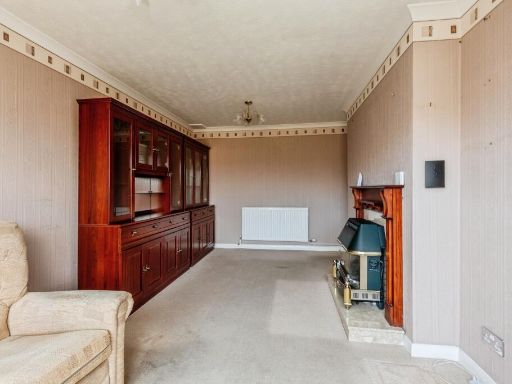
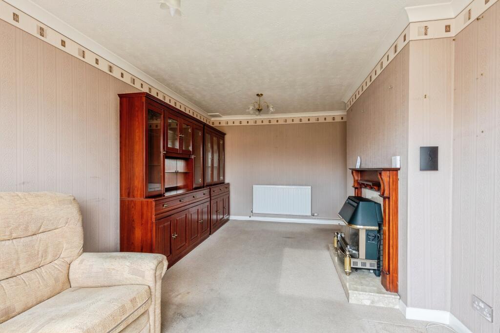
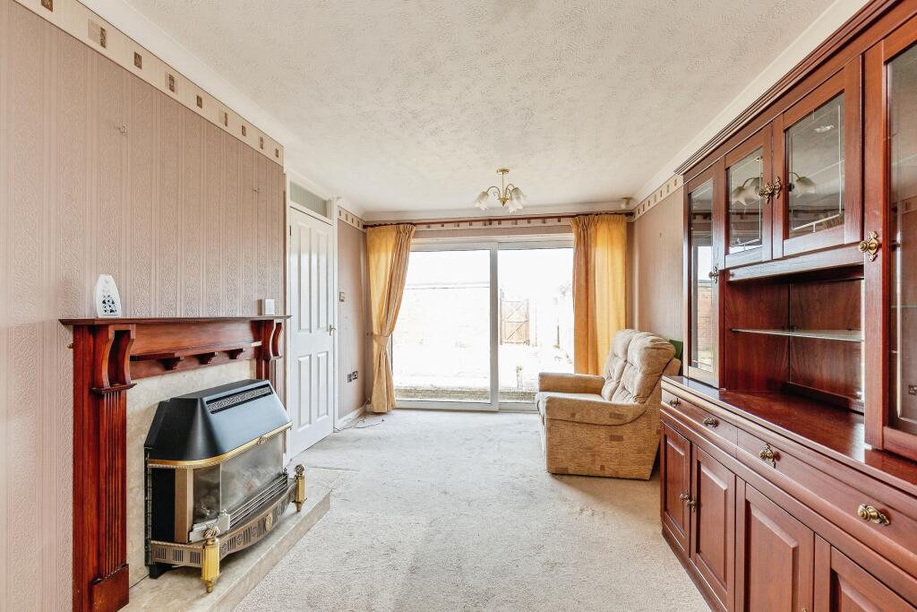
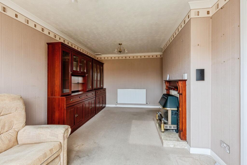
- Living Room:
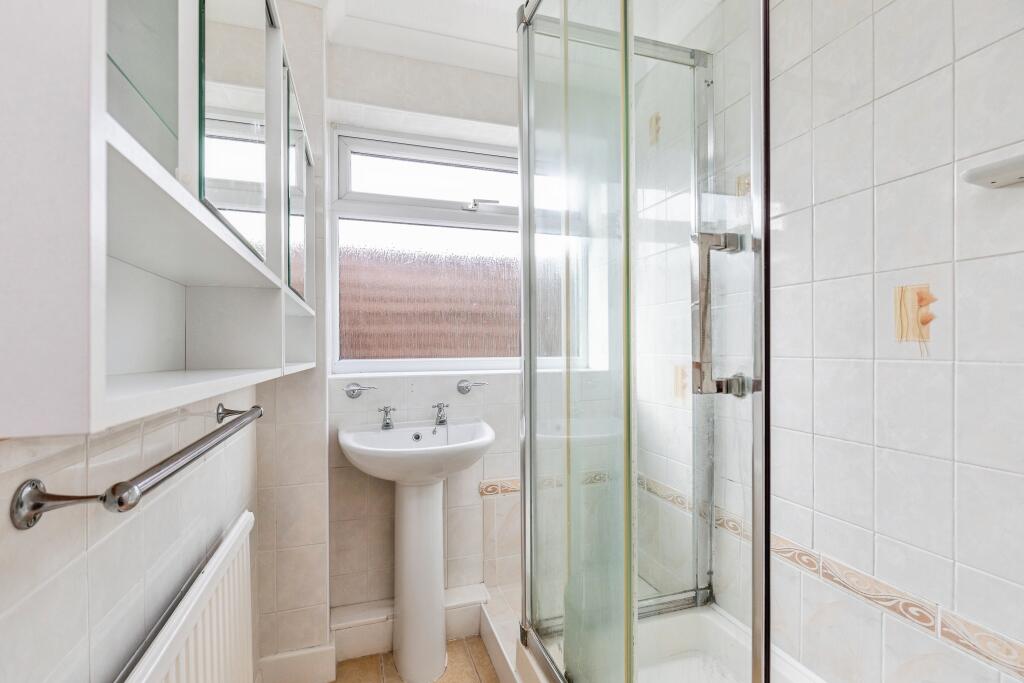
- Bathroom:
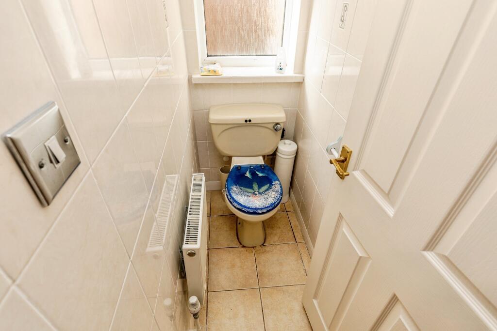
- W.C.:
- Hall:
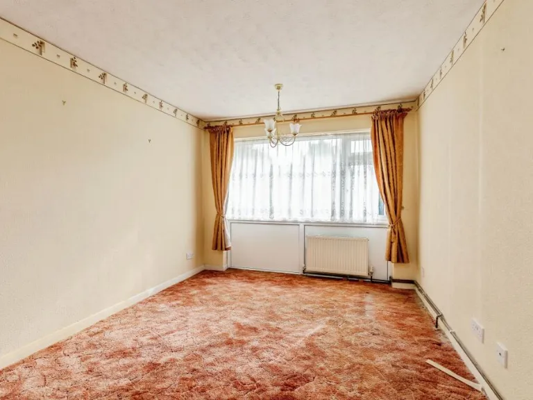
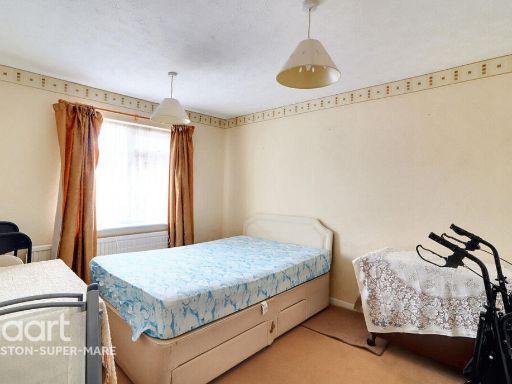
- Bedroom 2:
- Bedroom 1:
Textual Property Features
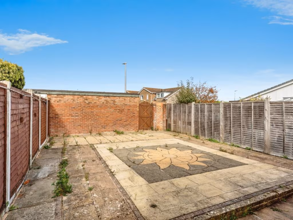
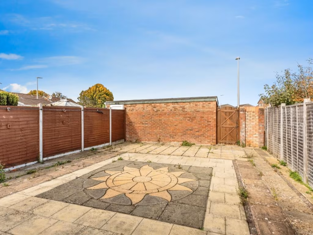
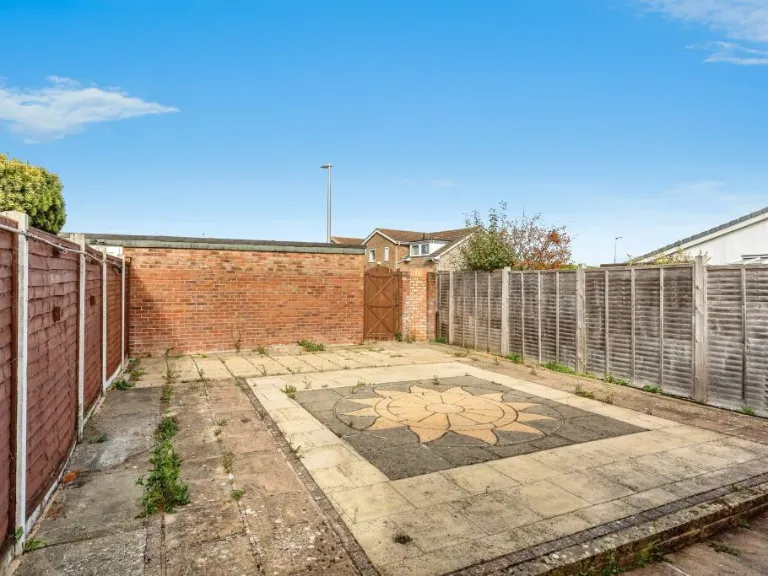
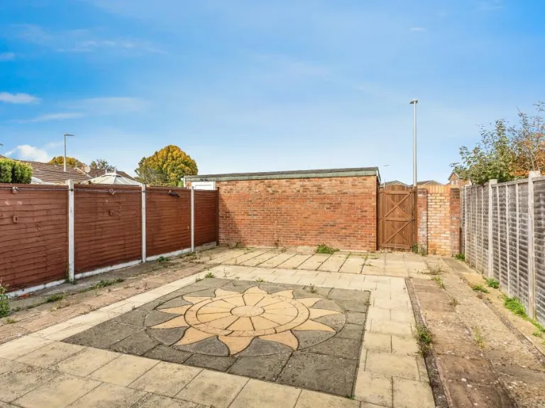
- Has Garden
- Chain Free
- Success
Detected Visual Features
- bungalow
- single-story
- solar panels
- brick
- patio
- suburban
- semi-detached
- mid-20th century
- dated exterior
- kitchen
- dated
- tile backsplash
- old appliances
- standard ceiling
- needs modernization
- single door
- window coverings
EPC Details
- Fully double glazed
- Cavity wall, as built, no insulation (assumed)
- Boiler and radiators, mains gas
- Low energy lighting in 50% of fixed outlets
- Solid, no insulation (assumed)
Nearby Schools
- Hutton Church of England Primary School
- Walliscote Primary School
- Worle Community School
- Mendip Green Primary School
- St Martin's Church of England Primary School
- Becket Primary School
- Priory Community School
- Oldmixon Primary School
- Windwhistle Primary School
- Bournville Primary School
- Winterstoke Hundred Academy
- Ashcombe Primary School
- Christ Church Church of England Primary School
- Mead Vale Community Primary School
- Milton Park Primary School
- Worle Village Primary School
- St Georges Church School
- Kewstoke Primary School
- Castle Batch Primary School Academy
- Locking Primary School
- Parklands Educate Together Primary
- Haywood Village Academy
- Hans Price Academy
- St Anne's Church Academy
- Herons' Moor Academy
- Worlebury St Pauls Church School
- St Mark's Ecumenical Anglican/Methodist Primary School
Nearest General Shops
- Id: 465916587
- Tags:
- Addr:
- City: Bristol
- Postcode: BS24 7AY
- Brand: Matalan
- Brand:wikidata: Q12061509
- Brand:wikipedia: en:Matalan
- Building: supermarket
- Name: Matalan
- Shop: clothes
- TagsNormalized:
- Lat: 51.3528638
- Lon: -2.9135519
- FullGeoHash: gcjujsw2j7dh
- PartitionGeoHash: gcju
- Images:
- FoodStandards: null
- Distance: 556.8
,- Id: 298452488
- Tags:
- Brand: Sue Ryder
- Brand:wikidata: Q7634271
- Brand:wikipedia: en:Sue Ryder (charity)
- Building: yes
- Building:levels: 3
- Name: Sue Ryder
- Shop: charity
- TagsNormalized:
- Lat: 51.3539093
- Lon: -2.9128671
- FullGeoHash: gcjujswyjq8c
- PartitionGeoHash: gcju
- Images:
- FoodStandards: null
- Distance: 536.8
,- Id: 465921031
- Tags:
- Brand: Ladbrokes
- Brand:wikidata: Q1799875
- Brand:wikipedia: en:Ladbrokes Coral
- Building: yes
- Building:levels: 3
- Name: Ladbrokes
- Shop: bookmaker
- TagsNormalized:
- Lat: 51.3537104
- Lon: -2.9134942
- FullGeoHash: gcjujswmn9mq
- PartitionGeoHash: gcju
- Images:
- FoodStandards: null
- Distance: 508
}
Nearest Grocery shops
- Id: 10196550800
- Tags:
- Addr:
- Housenumber: 32
- Postcode: BS22 6EQ
- Street: High Street
- Name: Maxxi Save
- Phone: +44 1934 511100
- Shop: convenience
- TagsNormalized:
- Lat: 51.3578297
- Lon: -2.932981
- FullGeoHash: gcjujm2m096g
- PartitionGeoHash: gcju
- Images:
- FoodStandards: null
- Distance: 933.6
,- Id: 317285097
- Tags:
- Addr:
- City: Weston-super-Mare
- Country: GB
- Housenumber: 148
- Postcode: BS22 6HG
- Street: High Street
- Village: Worle
- Building: yes
- Fhrs:
- Name: The co-operative food
- Opening_hours: Mo-Sa 06:00-22:00; Su 10:00-16:00
- Shop: supermarket
- Source: OS_OpenData_StreetView
- TagsNormalized:
- the co-operative food
- food
- shop
- Lat: 51.3598116
- Lon: -2.9281743
- FullGeoHash: gcjujmgb8dfc
- PartitionGeoHash: gcju
- Images:
- FoodStandards:
- Id: 1125950
- FHRSID: 1125950
- LocalAuthorityBusinessID: A06KWM148H/1
- BusinessName: Co-operative
- BusinessType: Retailers - supermarkets/hypermarkets
- BusinessTypeID: 7840
- AddressLine1: null
- AddressLine2: 148 High Street
- AddressLine3: Worle
- AddressLine4: Weston-Super-Mare, North Somer
- PostCode: BS22 6HG
- RatingValue: 5
- RatingKey: fhrs_5_en-GB
- RatingDate: 2022-11-24
- LocalAuthorityCode: 858
- LocalAuthorityName: North Somerset
- LocalAuthorityWebSite: http://www.n-somerset.gov.uk
- LocalAuthorityEmailAddress: foodandsafety@n-somerset.gov.uk
- Scores:
- Hygiene: 0
- Structural: 0
- ConfidenceInManagement: 0
- NewRatingPending: false
- Geocode:
- Longitude: -2.92843610000000
- Latitude: 51.35991620000000
- Distance: 719.1
,- Id: 95749713
- Tags:
- Brand: Morrisons
- Brand:wikidata: Q922344
- Brand:wikipedia: en:Morrisons
- Building: yes
- Name: Morrisons
- Note: Petrol station shop attached to larger store.
- Shop: convenience
- Website: https://my.morrisons.com/storefinder/341
- TagsNormalized:
- Lat: 51.3532798
- Lon: -2.9116796
- FullGeoHash: gcjujsxf8cnq
- PartitionGeoHash: gcju
- Images:
- FoodStandards: null
- Distance: 641.7
}
Nearest Supermarkets
- Id: 55862788
- Tags:
- Addr:
- City: Weston-Super-Mare
- Country: GB
- County: Somerset
- Postcode: BS22 6BL
- Street: Queensway
- Village: Worle
- Brand: Sainsbury's
- Brand:wikidata: Q152096
- Brand:wikipedia: en:Sainsbury's
- Building: yes
- Fhrs:
- Name: Sainsbury's
- Opening_hours: Mo-Fr 07:00-22:00; Sa 07:00-21:00; Su 10:0-16:00
- Operator: J Sainsbury Plc
- Shop: supermarket
- Source: OS_OpenData_StreetView
- Source:addr: FHRS Open Data
- TagsNormalized:
- sainsburys
- supermarket
- shop
- Lat: 51.3617491
- Lon: -2.9111564
- FullGeoHash: gcjujy05v5ur
- PartitionGeoHash: gcju
- Images:
- FoodStandards:
- Id: 151282
- FHRSID: 151282
- LocalAuthorityBusinessID: A06FWMQUEE/1
- BusinessName: Sainsbury's
- BusinessType: Retailers - supermarkets/hypermarkets
- BusinessTypeID: 7840
- AddressLine1: J Sainsbury Plc
- AddressLine2: Queensway
- AddressLine3: Worle
- AddressLine4: Weston-Super-Mare
- PostCode: BS22 6BL
- RatingValue: 5
- RatingKey: fhrs_5_en-GB
- RatingDate: 2021-07-08
- LocalAuthorityCode: 858
- LocalAuthorityName: North Somerset
- LocalAuthorityWebSite: http://www.n-somerset.gov.uk
- LocalAuthorityEmailAddress: foodandsafety@n-somerset.gov.uk
- Scores:
- Hygiene: 0
- Structural: 0
- ConfidenceInManagement: 0
- NewRatingPending: false
- Geocode:
- Longitude: -2.90916200000000
- Latitude: 51.36177800000000
- Distance: 885.8
,- Id: 95347918
- Tags:
- Addr:
- City: Worle
- Postcode: BS22 6WE
- Street: Summer Lane
- Brand: Lidl
- Brand:wikidata: Q151954
- Brand:wikipedia: en:Lidl
- Building: yes
- Name: Lidl
- Operator: Lidl
- Shop: supermarket
- Source: OS_OpenData_StreetView
- TagsNormalized:
- Lat: 51.3586765
- Lon: -2.9111797
- FullGeoHash: gcjujv81ux5n
- PartitionGeoHash: gcju
- Images:
- FoodStandards: null
- Distance: 676.7
,- Id: 95749653
- Tags:
- Brand: Morrisons
- Brand:wikidata: Q922344
- Brand:wikipedia: en:Morrisons
- Building: supermarket
- Name: Morrisons
- Opening_hours: Mo-We 08:30-20:00; Th,Fr 08:30-21:00; Sa 08:00-20:00; Su,PH 10:00-16:00
- Shop: supermarket
- Website: https://my.morrisons.com/storefinder/341
- TagsNormalized:
- Lat: 51.3523021
- Lon: -2.9129587
- FullGeoHash: gcjujsqug4uw
- PartitionGeoHash: gcju
- Images:
- FoodStandards: null
- Distance: 628.1
}
Nearest Religious buildings
- Id: 187543869
- Tags:
- Amenity: parking
- Capacity: 2
- Name: St. Martin's Church car park
- Parking: surface
- Source: bing
- TagsNormalized:
- Lat: 51.3616857
- Lon: -2.9301084
- FullGeoHash: gcjujq47e80v
- PartitionGeoHash: gcju
- Images:
- FoodStandards: null
- Distance: 955.4
,- Id: 95844537
- Tags:
- Addr:
- City: Bristol
- Postcode: BS22 7PW
- Amenity: place_of_worship
- Building: church
- Denomination: anglican
- Name: St Mark's Church
- Religion: christian
- Wikidata: Q105091129
- TagsNormalized:
- place of worship
- church
- anglican
- christian
- Lat: 51.3640795
- Lon: -2.9193583
- FullGeoHash: gcjujwd1qn2s
- PartitionGeoHash: gcju
- Images:
- FoodStandards: null
- Distance: 906.1
,- Id: 661228068
- Tags:
- Addr:
- City: Weston-Super-Mare
- Postcode: BS24 7JW
- Street: Jasmine Way
- Amenity: place_of_worship
- Building: church
- Denomination: anglican
- Fhrs:
- Name: Locking Castle Church
- Religion: christian
- Source:
- Wikidata: Q105091133
- TagsNormalized:
- place of worship
- church
- anglican
- christian
- Lat: 51.3546711
- Lon: -2.9128731
- FullGeoHash: gcjujsyfths3
- PartitionGeoHash: gcju
- Images:
- FoodStandards:
- Id: 1052471
- FHRSID: 1052471
- LocalAuthorityBusinessID: U07JWMJASM/1
- BusinessName: Locking Castle Church Community Hall
- BusinessType: School/college/university
- BusinessTypeID: 7845
- AddressLine1: null
- AddressLine2: Jasmine Way
- AddressLine3: Weston-Super-Mare
- AddressLine4: null
- PostCode: BS24 7JW
- RatingValue: 5
- RatingKey: fhrs_5_en-GB
- RatingDate: 2021-11-24
- LocalAuthorityCode: 858
- LocalAuthorityName: North Somerset
- LocalAuthorityWebSite: http://www.n-somerset.gov.uk
- LocalAuthorityEmailAddress: foodandsafety@n-somerset.gov.uk
- Scores:
- Hygiene: 0
- Structural: 0
- ConfidenceInManagement: 0
- NewRatingPending: false
- Geocode:
- Longitude: -2.91487097740173
- Latitude: 51.35417175292970
- Distance: 506.7
}
Nearest Medical buildings
- Id: 95749652
- Tags:
- Amenity: pharmacy
- Brand: Boots
- Brand:wikidata: Q6123139
- Brand:wikipedia: en:Boots (company)
- Building: supermarket
- Dispensing: yes
- Healthcare: pharmacy
- Name: Boots
- TagsNormalized:
- pharmacy
- boots
- health
- healthcare
- Lat: 51.3531135
- Lon: -2.9139063
- FullGeoHash: gcjujsw1t41y
- PartitionGeoHash: gcju
- Images:
- FoodStandards: null
- Distance: 520.4
,- Id: 298452493
- Tags:
- Amenity: clinic
- Building: yes
- Healthcare: clinic
- Name: Locking Castle Medical Centre
- TagsNormalized:
- Lat: 51.3532958
- Lon: -2.9142729
- FullGeoHash: gcjujstfss0t
- PartitionGeoHash: gcju
- Images:
- FoodStandards: null
- Distance: 487.9
,- Id: 637815453
- Tags:
- Addr:
- City: Bristol
- Housenumber: 87
- Postcode: BS22 6AJ
- Street: New Bristol Road
- Amenity: doctors
- Building: yes
- Healthcare: doctor
- Name: Cedar Surgery
- TagsNormalized:
- doctor
- doctors
- health
- healthcare
- surgery
- Lat: 51.358061
- Lon: -2.9235638
- FullGeoHash: gcjujmrnkh2z
- PartitionGeoHash: gcju
- Images:
- FoodStandards: null
- Distance: 348
,- Id: 454519748
- Tags:
- Amenity: doctors
- Healthcare: doctor
- TagsNormalized:
- doctor
- doctors
- health
- healthcare
- Lat: 51.3580632
- Lon: -2.9235553
- FullGeoHash: gcjujmrnkhzh
- PartitionGeoHash: gcju
- Images:
- FoodStandards: null
- Distance: 347.7
}
Nearest Airports
- Id: 47483196
- Tags:
- Aerodrome: international
- Aeroway: aerodrome
- Iata: BRS
- Icao: EGGD
- Internet_access: wlan
- Internet_access:fee: no
- Name: Bristol Airport
- Type: public
- Website: https://www.bristolairport.co.uk/
- Wikidata: Q8725
- Wikipedia: en:Bristol Airport
- TagsNormalized:
- airport
- international airport
- Lat: 51.3830799
- Lon: -2.7186615
- FullGeoHash: gcnh64h24s74
- PartitionGeoHash: gcnh
- Images:
- FoodStandards: null
- Distance: 14290.8
,- Id: 319112968
- Tags:
- Aerodrome: international
- Aerodrome:type: public
- Aeroway: aerodrome
- Iata: CWL
- Icao: EGFF
- Internet_access: yes
- Internet_access:fee: no
- Is_in: Cardiff,Wales,UK
- Name: Cardiff Airport
- Operator: Cardiff International Airport Limited
- Source: Gagravarr_Airports
- Type: civil
- Wikidata: Q8994
- Wikipedia: en:Cardiff Airport
- TagsNormalized:
- airport
- international airport
- Lat: 51.3978554
- Lon: -3.3438203
- FullGeoHash: gcjs7utn5qdy
- PartitionGeoHash: gcjs
- Images:
- FoodStandards: null
- Distance: 29791.2
}
Nearest Leisure Facilities
- Id: 1082676883
- Tags:
- Leisure: pitch
- Sport: soccer
- TagsNormalized:
- Lat: 51.3587959
- Lon: -2.9222154
- FullGeoHash: gcjujt84emqr
- PartitionGeoHash: gcju
- Images:
- FoodStandards: null
- Distance: 356.8
,- Id: 35452044
- Tags:
- TagsNormalized:
- Lat: 51.3573128
- Lon: -2.9157575
- FullGeoHash: gcjujtkf1cj8
- PartitionGeoHash: gcju
- Images:
- FoodStandards: null
- Distance: 324.7
,- Id: 1082676882
- Tags:
- TagsNormalized:
- Lat: 51.3581688
- Lon: -2.9228596
- FullGeoHash: gcjujmrxh2tf
- PartitionGeoHash: gcju
- Images:
- FoodStandards: null
- Distance: 323
,- Id: 551829649
- Tags:
- TagsNormalized:
- Lat: 51.3544925
- Lon: -2.9162107
- FullGeoHash: gcjujsu3x778
- PartitionGeoHash: gcju
- Images:
- FoodStandards: null
- Distance: 301.4
,- Id: 240731783
- Tags:
- Leisure: pitch
- Source: survey
- TagsNormalized:
- Lat: 51.3558897
- Lon: -2.9175837
- FullGeoHash: gcjujt53xrey
- PartitionGeoHash: gcju
- Images:
- FoodStandards: null
- Distance: 159.7
}
Nearest Tourist attractions
- Id: 55489967
- Tags:
- Addr:
- Name: West End Farm Caravan Park
- Source: OS_OpenSource_StreetView
- Tourism: caravan_site
- TagsNormalized:
- Lat: 51.3336956
- Lon: -2.9288902
- FullGeoHash: gcjuj350rymj
- PartitionGeoHash: gcju
- Images:
- FoodStandards: null
- Distance: 2551.1
,- Id: 107947405
- Tags:
- Addr:
- City: Bristol
- Postcode: BS24 8PP
- Building: yes
- Name: Helicopter Museum
- Note: History of Weston Airport
- Tourism: museum
- Wikidata: Q7739330
- Wikipedia: en:The Helicopter Museum (Weston)
- TagsNormalized:
- Lat: 51.3392316
- Lon: -2.9312087
- FullGeoHash: gcjuj6189ykm
- PartitionGeoHash: gcju
- Images:
- FoodStandards: null
- Distance: 2017.3
,- Id: 7566377885
- Tags:
- Name: view over to sand point
- Tourism: attraction
- TagsNormalized:
- Lat: 51.3659787
- Lon: -2.9342154
- FullGeoHash: gcjujnzkeb6q
- PartitionGeoHash: gcju
- Images:
- FoodStandards: null
- Distance: 1495.7
}
Nearest Train stations
- Id: 492098581
- Tags:
- Internet_access: no
- Name: Nailsea and Backwell
- Naptan:
- Network: National Rail
- Operator: GWR
- Public_transport: station
- Railway: station
- Ref:
- Source: GPX + NPE
- Wikidata: Q6959642
- Wikipedia: en:Nailsea and Backwell railway station
- TagsNormalized:
- Lat: 51.4196718
- Lon: -2.7496898
- FullGeoHash: gcnh92ttr9d9
- PartitionGeoHash: gcnh
- Images:
- FoodStandards: null
- Distance: 13773
,- Id: 21277558
- Tags:
- Name: Yatton
- Naptan:
- Network: National Rail
- Operator: GWR
- Platforms: 2
- Public_transport: station
- Railway: station
- Ref:
- Source: NPE + GPX
- Wikidata: Q1957149
- Wikipedia: en:Yatton railway station
- TagsNormalized:
- Lat: 51.3908826
- Lon: -2.8277046
- FullGeoHash: gcjurekvtdye
- PartitionGeoHash: gcju
- Images:
- FoodStandards: null
- Distance: 7485.8
,- Id: 21277582
- Tags:
- Name: Weston-super-Mare
- Naptan:
- Network: National Rail
- Public_transport: station
- Railway: station
- Ref:
- Source: NPE
- Wikidata: Q2335883
- Wikipedia: en:Weston-super-Mare railway station
- TagsNormalized:
- Lat: 51.344496
- Lon: -2.9718305
- FullGeoHash: gcjuh6gzr7f8
- PartitionGeoHash: gcju
- Images:
- FoodStandards: null
- Distance: 3825.5
,- Id: 21277557
- Tags:
- Name: Weston Milton
- Naptan:
- Network: National Rail
- Operator: GWR
- Public_transport: station
- Railway: station
- Ref:
- Source: NPE + GPX
- Wikidata: Q2432877
- Wikipedia: en:Weston Milton railway station
- TagsNormalized:
- Lat: 51.3485177
- Lon: -2.9422803
- FullGeoHash: gcjuj59qzckz
- PartitionGeoHash: gcju
- Images:
- FoodStandards: null
- Distance: 1760.7
,- Id: 253893851
- Tags:
- Name: Worle
- Naptan:
- Network: National Rail
- Public_transport: station
- Railway: station
- Ref:
- Wikidata: Q2416797
- Wikipedia: en:Worle railway station
- TagsNormalized:
- Lat: 51.3578502
- Lon: -2.9093225
- FullGeoHash: gcjujv3mpv5v
- PartitionGeoHash: gcju
- Images:
- FoodStandards: null
- Distance: 763.5
}
Nearest Hotels
- Id: 8817914283
- Tags:
- Addr:
- Housename: The Owls Crest House
- Postcode: BS22 9YE
- Street: Kewstoke Road
- Name: Owls Crest House
- Tourism: hotel
- TagsNormalized:
- Lat: 51.365785
- Lon: -2.9552764
- FullGeoHash: gcjuhyb53h64
- PartitionGeoHash: gcju
- Images:
- FoodStandards: null
- Distance: 2690.4
,- Id: 13040476
- Tags:
- Brand: Premier Inn
- Brand:wikidata: Q2108626
- Brand:wikipedia: en:Premier Inn
- Building: yes
- Internet_access: wlan
- Internet_access:fee: customers
- Internet_access:operator: Virgin Media
- Internet_access:ssid: Premier Inn Free Wi-Fi
- Name: Premier Inn
- Source: OS_OpenData_StreetView
- Tourism: hotel
- Type: multipolygon
- TagsNormalized:
- Lat: 51.3440481
- Lon: -2.9488394
- FullGeoHash: gcjuhfusz03b
- PartitionGeoHash: gcju
- Images:
- FoodStandards: null
- Distance: 2406.7
,- Id: 490201899
- Tags:
- Brand: Travelodge
- Brand:wikidata: Q9361374
- Brand:wikipedia: en:Travelodge UK
- Building: yes
- Internet_access: wlan
- Internet_access:fee: customers
- Internet_access:ssid: Travelodge WiFi
- Name: Travelodge
- Source: Bing
- Tourism: hotel
- TagsNormalized:
- Lat: 51.3428752
- Lon: -2.9336117
- FullGeoHash: gcjuj4xvcvss
- PartitionGeoHash: gcju
- Images:
- FoodStandards: null
- Distance: 1737.5
}
Tags
- bungalow
- single-story
- solar panels
- brick
- patio
- suburban
- semi-detached
- mid-20th century
- dated exterior
- kitchen
- dated
- tile backsplash
- old appliances
- standard ceiling
- needs modernization
- single door
- window coverings
Local Market Stats
- Average Price/sqft: £305
- Avg Income: £45100
- Rental Yield: 4.8%
- Social Housing: 10%
- Planning Success Rate: 92%
Similar Properties
 2 bedroom bungalow for sale in Elderberry Walk, Weston-Super-Mare, BS22 — £240,000 • 2 bed • 1 bath • 584 ft²
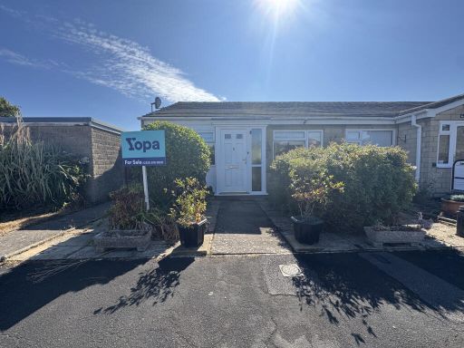 2 bedroom semi-detached bungalow for sale in Turnbury Close, Weston-super-mare, BS22 — £240,000 • 2 bed • 1 bath • 755 ft²
 2 bedroom semi-detached bungalow for sale in Coalbridge Close, BS22 — £250,000 • 2 bed • 1 bath • 532 ft²
 2 bedroom semi-detached bungalow for sale in Orchard Close, Worle, Weston-Super-Mare, BS22 — £265,000 • 2 bed • 1 bath • 894 ft²
 House for sale in Tor Close, Weston-Super-Mare, BS22 — £240,000 • 1 bed • 1 bath • 8905 ft²
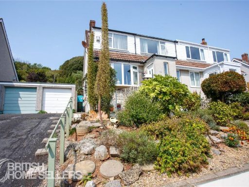 3 bedroom semi-detached house for sale in Pleshey Close, Weston-super-Mare, Somerset, BS22 — £325,000 • 3 bed • 2 bath • 1228 ft²
Meta
- {
"@context": "https://schema.org",
"@type": "Residence",
"name": "2 bedroom semidetached bungalow for sale in Elderberry Walk…",
"description": "",
"url": "https://propertypiper.co.uk/property/f53bf0d8-8c49-472a-b807-81af10331036",
"image": "https://image-a.propertypiper.co.uk/40e57d88-e026-4e05-be98-ce629b4b87f3-1024.jpeg",
"address": {
"@type": "PostalAddress",
"streetAddress": "10 ELDERBERRY WALK WESTON-SUPER-MARE",
"postalCode": "BS22 6SN",
"addressLocality": "North Somerset",
"addressRegion": "Weston-Super-Mare",
"addressCountry": "England"
},
"geo": {
"@type": "GeoCoordinates",
"latitude": 51.3559375,
"longitude": -2.9198821
},
"numberOfRooms": 2,
"numberOfBathroomsTotal": 1,
"floorSize": {
"@type": "QuantitativeValue",
"value": 603,
"unitCode": "FTK"
},
"offers": {
"@type": "Offer",
"price": 240000,
"priceCurrency": "GBP",
"availability": "https://schema.org/InStock"
},
"additionalProperty": [
{
"@type": "PropertyValue",
"name": "Feature",
"value": "bungalow"
},
{
"@type": "PropertyValue",
"name": "Feature",
"value": "single-story"
},
{
"@type": "PropertyValue",
"name": "Feature",
"value": "solar panels"
},
{
"@type": "PropertyValue",
"name": "Feature",
"value": "brick"
},
{
"@type": "PropertyValue",
"name": "Feature",
"value": "patio"
},
{
"@type": "PropertyValue",
"name": "Feature",
"value": "suburban"
},
{
"@type": "PropertyValue",
"name": "Feature",
"value": "semi-detached"
},
{
"@type": "PropertyValue",
"name": "Feature",
"value": "mid-20th century"
},
{
"@type": "PropertyValue",
"name": "Feature",
"value": "dated exterior"
},
{
"@type": "PropertyValue",
"name": "Feature",
"value": "kitchen"
},
{
"@type": "PropertyValue",
"name": "Feature",
"value": "dated"
},
{
"@type": "PropertyValue",
"name": "Feature",
"value": "tile backsplash"
},
{
"@type": "PropertyValue",
"name": "Feature",
"value": "old appliances"
},
{
"@type": "PropertyValue",
"name": "Feature",
"value": "standard ceiling"
},
{
"@type": "PropertyValue",
"name": "Feature",
"value": "needs modernization"
},
{
"@type": "PropertyValue",
"name": "Feature",
"value": "single door"
},
{
"@type": "PropertyValue",
"name": "Feature",
"value": "window coverings"
}
]
}
High Res Floorplan Images
Compatible Floorplan Images
FloorplanImages Thumbnail