NE4 7DX - 2 bedroom apartment for sale in Park Road, The Cedars Park…
View on Property Piper
2 bedroom apartment for sale in Park Road, The Cedars Park Road, NE4
Property Details
- Price: £55000
- Bedrooms: 2
- Bathrooms: 1
- Property Type: undefined
- Property SubType: undefined
Image Descriptions
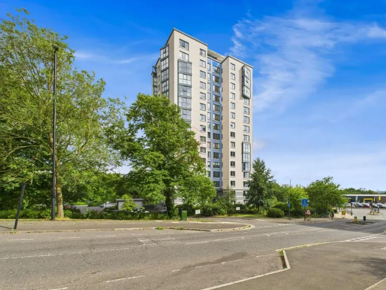
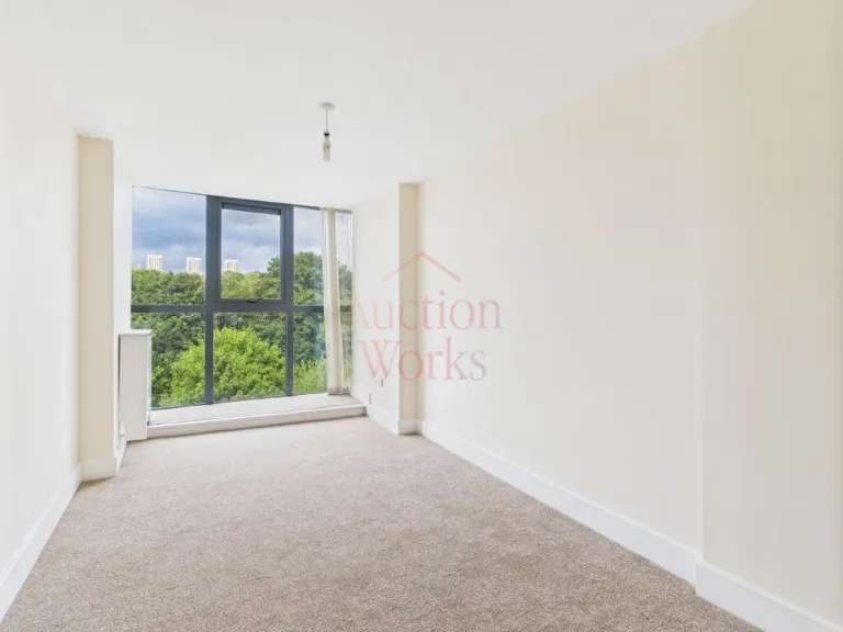
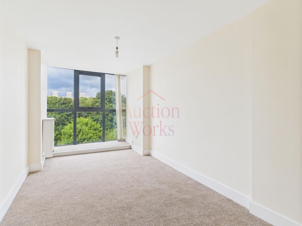
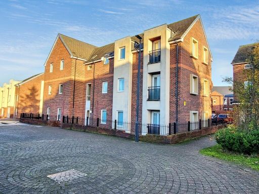
- apartment building Modern High-Rise
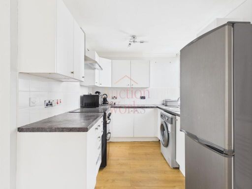
- kitchen modern
Rooms
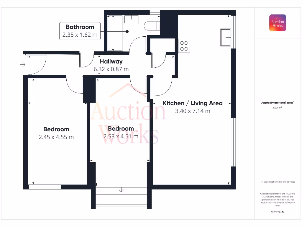
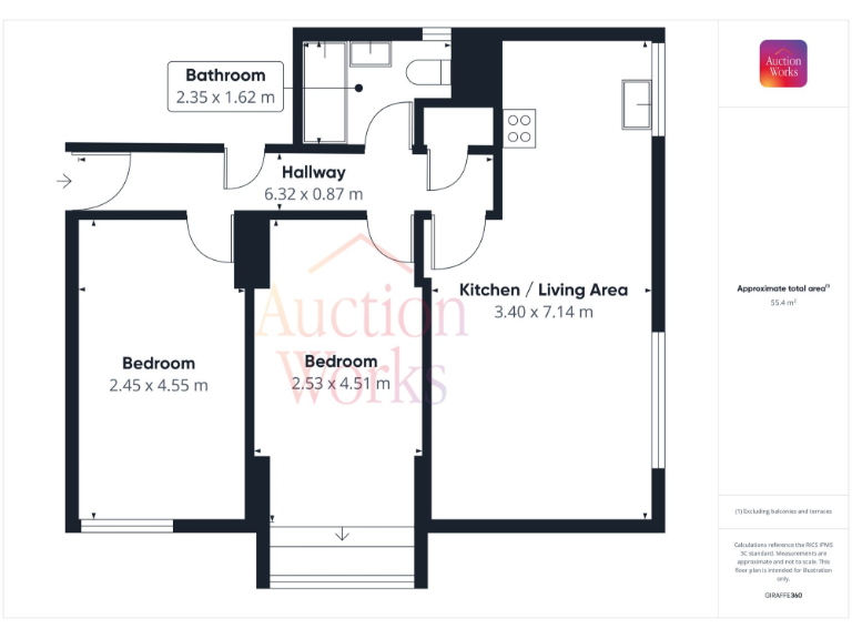
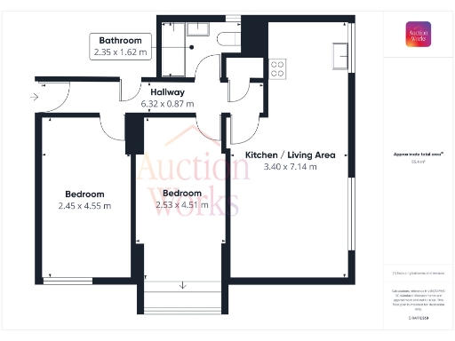
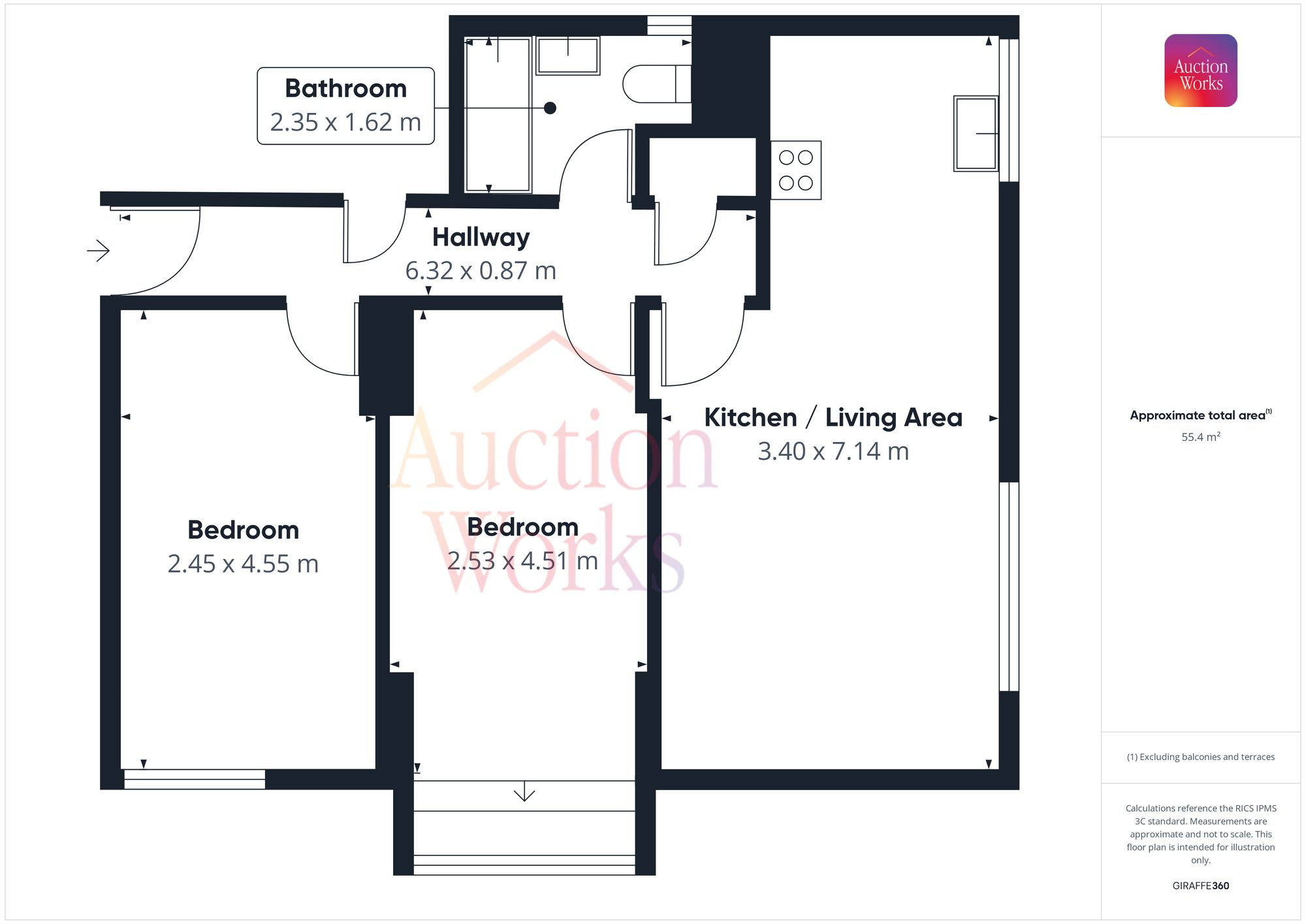
- Bathroom:
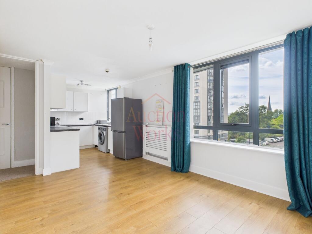
- Hallway:
- Kitchen / Living Area:
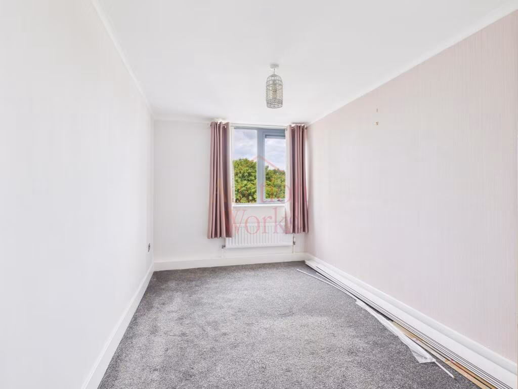
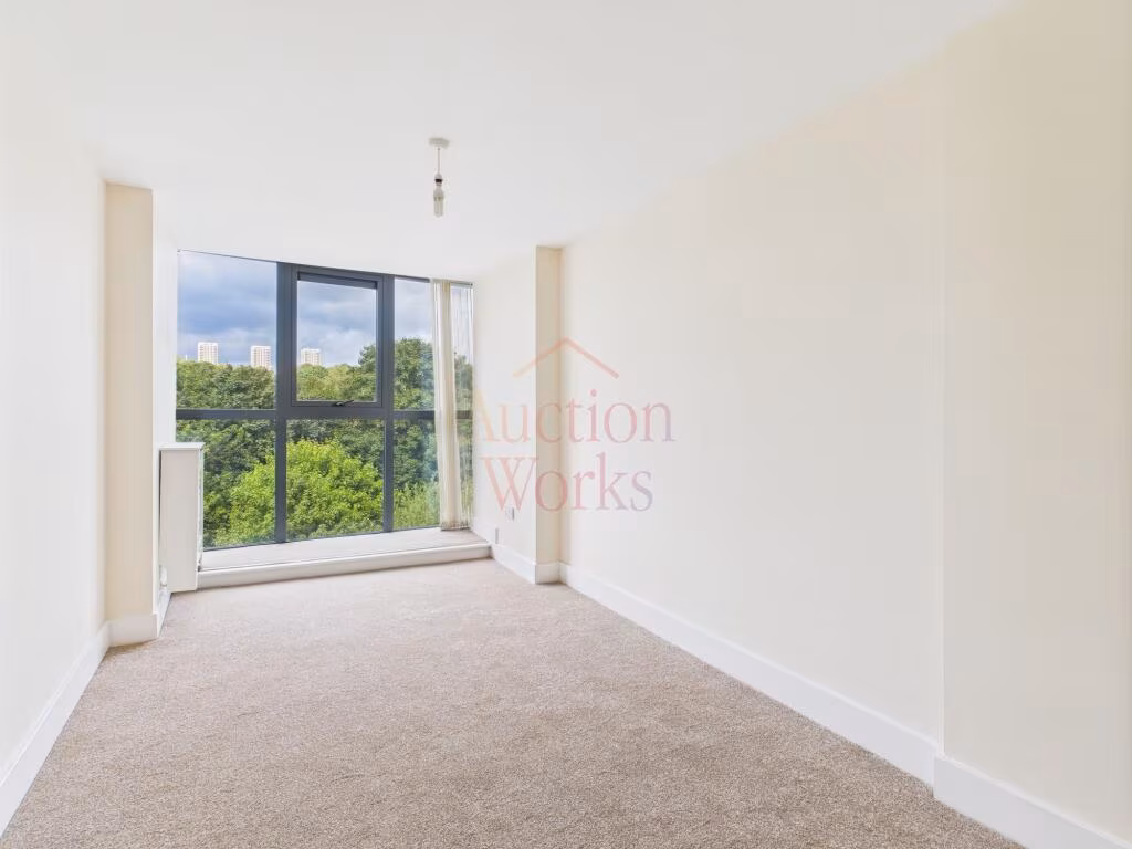
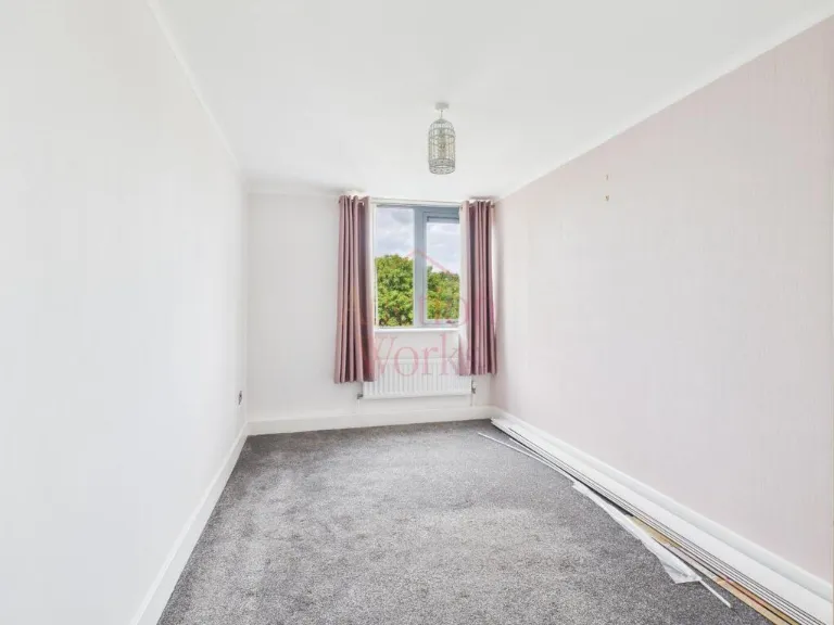
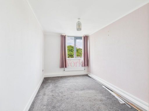
- Bedroom:
- Bedroom:
Textual Property Features
Detected Visual Features
- apartment
- high-rise
- modern
- urban
- city living
- views
- centrally located
- modern kitchen
- white cabinets
- wood flooring
- small kitchen
- integrated appliances
EPC Details
- Fully double glazed
- System built, with external insulation
- Community scheme
- Low energy lighting in 63% of fixed outlets
- (another dwelling below)
Nearby Schools
- Emmanuel College
- St Philip Neri Catholic Primary School, Dunston
- Bahr Academy
- Canning Street Primary School
- Dame Allan's Senior School
- Kelvin Grove Community Primary School
- Dunston Hill Community Primary School
- Kingsmeadow Community Comprehensive School
- Brighton Avenue Primary School
- Gateshead Jewish Boarding School
- St Michael's Catholic Primary School
- St Paul's CofE Primary School
- Moorside Primary School
- Corpus Christi Catholic Primary School, Gateshead
- North East Futures UTC
- St Johns Primary School
- Hawthorn Primary School
- Our Lady and St Anne's Catholic Primary School
- Wingrove Primary School
- Lobley Hill Primary School
- Riverside Primary Academy
- Callerton Academy
- West Newcastle Academy
- Westgate Hill Primary Academy
Nearest General Shops
- Id: 6855654353
- Tags:
- Brand: Toolstation
- Brand:wikidata: Q7824103
- Brand:wikipedia: en:Toolstation
- Name: Toolstation
- Shop: doityourself
- TagsNormalized:
- station
- toolstation
- doityourself
- shop
- Lat: 54.9636043
- Lon: -1.6313866
- FullGeoHash: gcybdvu41ymy
- PartitionGeoHash: gcyb
- Images:
- FoodStandards: null
- Distance: 172.1
,- Id: 4555490836
- Tags:
- Addr:
- City: Newcastle Upon Tyne
- Street: Penn Street
- Name: Kestrel Truck Services
- Shop: car_repair
- TagsNormalized:
- service
- car repair
- repair
- shop
- Lat: 54.9629667
- Lon: -1.6322539
- FullGeoHash: gcybdveqmxx7
- PartitionGeoHash: gcyb
- Images:
- FoodStandards: null
- Distance: 151.4
,- Id: 460553624
- Tags:
- Addr:
- City: Newcastle upon Tyne
- Postcode: NE4 7BP
- Street: Scotswood Road
- Building: yes
- Fixme: check building size
- Name: Arnold Clark - Ford
- Phone: +44 191 644 0708
- Shop: car
- Website: https://www.arnoldclark.com/find-a-dealer/newcastle-ford/ref/arnam
- TagsNormalized:
- Lat: 54.9629308
- Lon: -1.6343713
- FullGeoHash: gcybdv9yk2um
- PartitionGeoHash: gcyb
- Images:
- FoodStandards: null
- Distance: 105.1
}
Nearest Grocery shops
- Id: 274521421
- Tags:
- Building: yes
- Cuisine: asian
- Name: The College Halal Deli
- Shop: convenience
- Toilets:
- Wheelchair: no
- TagsNormalized:
- asian
- college
- halal
- deli
- convenience
- shop
- Lat: 54.967156
- Lon: -1.6258411
- FullGeoHash: gcyben2nght1
- PartitionGeoHash: gcyb
- Images:
- FoodStandards: null
- Distance: 639.4
,- Id: 4563413436
- Tags:
- Addr:
- City: Newcastle upon Tyne
- Housename: Cruddas Park Shopping Centre
- Postcode: NE4 7RW
- Street: Westmorland Road
- Unit: 1
- Brand: McColl's
- Brand:wikidata: Q16997477
- Brand:wikipedia: en:McColl's
- Contact:
- Website: https://www.mccolls.co.uk/storelocator/newcastle-cruddas-park/
- Fhrs:
- Name: McColl's
- Shop: convenience
- Source:
- TagsNormalized:
- Lat: 54.9659823
- Lon: -1.6376346
- FullGeoHash: gcybdwr803g0
- PartitionGeoHash: gcyb
- Images:
- FoodStandards: null
- Distance: 329
,- Id: 4563413417
- Tags:
- Addr:
- City: Newcastle upon Tyne
- Housenumber: 68
- Postcode: NE4 7EH
- Street: Cambridge Street
- Fhrs:
- Name: Iriana
- Shop: convenience
- Source:
- TagsNormalized:
- Lat: 54.9651696
- Lon: -1.6349776
- FullGeoHash: gcybdy17q622
- PartitionGeoHash: gcyb
- Images:
- FoodStandards:
- Id: 958183
- FHRSID: 958183
- LocalAuthorityBusinessID: 17/00114/MIXED
- BusinessName: Iriana Convenience Store
- BusinessType: Retailers - other
- BusinessTypeID: 4613
- AddressLine1: Iriana Convenience Store, 68 Cambridge Street
- AddressLine2: null
- AddressLine3: Newcastle Upon Tyne
- AddressLine4: null
- PostCode: NE4 7EH
- RatingValue: 5
- RatingKey: fhrs_5_en-GB
- RatingDate: 2017-03-27
- LocalAuthorityCode: 416
- LocalAuthorityName: Newcastle Upon Tyne
- LocalAuthorityWebSite: http://www.newcastle.gov.uk/
- LocalAuthorityEmailAddress: psr@newcastle.gov.uk
- Scores:
- Hygiene: 0
- Structural: 0
- ConfidenceInManagement: 0
- NewRatingPending: false
- Geocode:
- Longitude: null
- Latitude: null
- Distance: 157.5
}
Nearest Religious buildings
- Id: 460739389
- Tags:
- Amenity: place_of_worship
- Building: yes
- Name: Central Hall Gospel Mission
- Religion: christian
- TagsNormalized:
- place of worship
- christian
- church
- Lat: 54.9671496
- Lon: -1.630819
- FullGeoHash: gcybdykqz5m5
- PartitionGeoHash: gcyb
- Images:
- FoodStandards: null
- Distance: 420.1
,- Id: 460736457
- Tags:
- Amenity: place_of_worship
- Building: yes
- Denomination: anglican
- Name: Elswick Parish Church St Stephens & St Pauls
- Religion: christian
- Wikidata: Q7595479
- Wikipedia: en:St Stephen's Church, Low Elswick
- TagsNormalized:
- place of worship
- anglican
- church
- parish
- christian
- Lat: 54.9632409
- Lon: -1.6395232
- FullGeoHash: gcybdty0h6dy
- PartitionGeoHash: gcyb
- Images:
- FoodStandards: null
- Distance: 356.3
,- Id: 400035762
- Tags:
- Amenity: place_of_worship
- Building: church
- Denomination: seventh_day_adventist
- Name: Newcastle upon Tyne Seventh-day Adventist Church
- Religion: christian
- TagsNormalized:
- place of worship
- church
- adventist
- seventh day adventist
- christian
- Lat: 54.9647148
- Lon: -1.6389659
- FullGeoHash: gcybdwn89m6r
- PartitionGeoHash: gcyb
- Images:
- FoodStandards: null
- Distance: 328.2
}
Nearest Medical buildings
- Id: 4513694860
- Tags:
- Addr:
- City: Newcastle Upon Tyne
- Street: Blandford Square
- Amenity: dentist
- Healthcare: dentist
- Name: PDS Dental Laboratory
- TagsNormalized:
- dentist
- health
- healthcare
- dental
- Lat: 54.9688088
- Lon: -1.6238149
- FullGeoHash: gcybenc8d2eu
- PartitionGeoHash: gcyb
- Images:
- FoodStandards: null
- Distance: 854.2
,- Id: 4587344310
- Tags:
- Addr:
- City: Newcastle upon Tyne
- Postcode: NE4 6SH
- Street: Meldon Street
- Amenity: doctors
- Name: Elswick Health Centre
- Phone: +44 333 321 8279
- Website: www.graingermedicalgroup.nhs.uk
- TagsNormalized:
- doctor
- doctors
- health
- health centre
- Lat: 54.9693217
- Lon: -1.6404815
- FullGeoHash: gcybdwv7w022
- PartitionGeoHash: gcyb
- Images:
- FoodStandards: null
- Distance: 733.4
,- Id: 826166628
- Tags:
- Addr:
- City: Newcastle upon Tyne
- Housenumber: 132
- Postcode: NE4 6SL
- Street: Elswick Road
- Amenity: pharmacy
- Name: Whitworth Chemists Ltd
- Phone: +44 191 273 8070
- Website: https://whitworthchemists.co.uk/
- TagsNormalized:
- Lat: 54.9688767
- Lon: -1.6405997
- FullGeoHash: gcybdwv2gm21
- PartitionGeoHash: gcyb
- Images:
- FoodStandards: null
- Distance: 697.5
,- Id: 4563568469
- Tags:
- Addr:
- City: Newcastle Upon Tyne
- Amenity: pharmacy
- Brand:
- Name: Boots
- TagsNormalized:
- Lat: 54.9661797
- Lon: -1.6362649
- FullGeoHash: gcybdy290q83
- PartitionGeoHash: gcyb
- Images:
- FoodStandards: null
- Distance: 294.5
}
Nearest Airports
- Id: 51496177
- Tags:
- Addr:
- City: Newcastle upon Tyne
- Housename: Newcastle International Airport
- Postcode: NE13 8BZ
- Street: Woolsington
- Aerodrome: international
- Aerodrome:type: public
- Aeroway: aerodrome
- Contact:
- Website: http://www.newcastleairport.com
- Ele: 81
- Iata: NCL
- Icao: EGNT
- Ifr: yes
- Name: Newcastle International Airport
- Old_name: Woolsington Aerodrome
- Operator: Newcastle International Airport Ltd
- Operator:type: private
- Phone: +44 871 882 1121
- Ref: NCL
- Size: 4500000
- Source: Bing
- Vfr: yes
- Website: https://www.newcastleairport.com/
- Wheelchair: yes
- Wikidata: Q8975
- Wikipedia: en:Newcastle International Airport
- TagsNormalized:
- airport
- international airport
- Lat: 55.0385826
- Lon: -1.6925163
- FullGeoHash: gcyc17rwcx2m
- PartitionGeoHash: gcyc
- Images:
- FoodStandards: null
- Distance: 9107.4
,- Id: 224091164
- Tags:
- Addr:
- City: Newcastle upon Tyne
- Postcode: NE13 8BZ
- Street: Woolsington
- Building: hotel
- Contact:
- Facebook: https://www.facebook.com/doubletree.newcastle
- Google_plus: https://plus.google.com/115643701064921491168/about
- Twitter: https://twitter.com/dtnewcastle_int
- Email: info@doubletree-newcastle.co.uk
- Fhrs:
- Name: DoubleTree by Hilton Hotel Newcastle International Airport
- Operator: Hilton Worldwide
- Phone: +44 1661 824266
- Rooms: 179
- Smoking: no
- Stars: 4
- Tourism: hotel
- Website: https://doubletree3.hilton.com/en/hotels/united-kingdom/doubletree-by-hilton-hotel-newcastle-international-airport-NCLNADI/index.html?WT.mc_id=zELWAKN0EMEA1DT2DMH3LocalSearch4DGGenericx6NCLNADI
- Wheelchair: yes
- TagsNormalized:
- hotel
- airport
- international airport
- tourism
- major airport
- Lat: 55.0364476
- Lon: -1.7124358
- FullGeoHash: gcyc1514937m
- PartitionGeoHash: gcyc
- Images:
- FoodStandards:
- Id: 236731
- FHRSID: 236731
- LocalAuthorityBusinessID: 11/00246/MIXED
- BusinessName: Doubletree By Hilton Hotel
- BusinessType: Hotel/bed & breakfast/guest house
- BusinessTypeID: 7842
- AddressLine1: Doubletree By Hilton Newcastle Airport
- AddressLine2: Woolsington
- AddressLine3: Newcastle Upon Tyne
- AddressLine4: null
- PostCode: NE13 8BZ
- RatingValue: 5
- RatingKey: fhrs_5_en-GB
- RatingDate: 2019-08-13
- LocalAuthorityCode: 416
- LocalAuthorityName: Newcastle Upon Tyne
- LocalAuthorityWebSite: http://www.newcastle.gov.uk/
- LocalAuthorityEmailAddress: psr@newcastle.gov.uk
- Scores:
- Hygiene: 0
- Structural: 5
- ConfidenceInManagement: 0
- NewRatingPending: false
- Geocode:
- Longitude: -1.71254240000000
- Latitude: 55.03664040000000
- Distance: 9494.6
}
Nearest Leisure Facilities
- Id: 1076097203
- Tags:
- TagsNormalized:
- Lat: 54.9676865
- Lon: -1.6380421
- FullGeoHash: gcybdwx1yz7q
- PartitionGeoHash: gcyb
- Images:
- FoodStandards: null
- Distance: 496.3
,- Id: 460767191
- Tags:
- TagsNormalized:
- Lat: 54.9672223
- Lon: -1.6342125
- FullGeoHash: gcybdy6p20fu
- PartitionGeoHash: gcyb
- Images:
- FoodStandards: null
- Distance: 374.3
,- Id: 4561866816
- Tags:
- Addr:
- City: Newcastle upon Tyne
- Housenumber: 26
- Postcode: NE4 7HX
- Street: Invincible Drive
- Leisure: fitness_centre
- Name: Northern Kings
- Phone: +44 191 580 5850
- Website: https://northernkings.co.uk/
- TagsNormalized:
- fitness
- fitness centre
- leisure
- Lat: 54.9619876
- Lon: -1.6359783
- FullGeoHash: gcybdv88ycn4
- PartitionGeoHash: gcyb
- Images:
- FoodStandards: null
- Distance: 241.7
,- Id: 4561866817
- Tags:
- Addr:
- City: Newcastle Upon Tyne
- Street: Invincible Drive
- Leisure: fitness_centre
- Name: Gym Elite
- TagsNormalized:
- fitness
- fitness centre
- leisure
- gym
- Lat: 54.962001
- Lon: -1.6357588
- FullGeoHash: gcybdv8bu59f
- PartitionGeoHash: gcyb
- Images:
- FoodStandards: null
- Distance: 233.6
,- Id: 709179895
- Tags:
- Addr:
- City: Newcastle Upon Tyne
- Postcode: NE4 7AF
- Street: Scotswood Road
- Building: yes
- Leisure: sports_centre
- Name: Vertu Motors Arena
- Sport: basketball;boxing
- TagsNormalized:
- sports
- sports centre
- leisure
- basketball
- boxing
- Lat: 54.9636178
- Lon: -1.6369617
- FullGeoHash: gcybdvb420bz
- PartitionGeoHash: gcyb
- Images:
- FoodStandards: null
- Distance: 188
}
Nearest Tourist attractions
- Id: 10695413646
- Tags:
- Addr:
- Postcode: NE1 4JA
- Street: Blandford Square
- Name: Discovery Museum
- Opening_hours: Mo-Fr 10:00-16:00; Sa, Su 11:00-16:00
- Operator: TW Museums
- Phone: +44 191 2326789
- Source: Bing
- Tourism: museum
- Website: https://discoverymuseum.org.uk/
- Wheelchair: yes
- Wikidata: Q4045311
- Wikipedia: en:Discovery Museum
- TagsNormalized:
- Lat: 54.9692513
- Lon: -1.6248071
- FullGeoHash: gcybenbg570h
- PartitionGeoHash: gcyb
- Images:
- FoodStandards: null
- Distance: 841.2
,- Id: 10695413645
- Tags:
- Name: Charge!
- Operator: Light Dragoons Association
- Tourism: museum
- Website: http://www.lightdragoons.org.uk/museum.html
- Wikidata: Q113369890
- TagsNormalized:
- Lat: 54.969125
- Lon: -1.6250646
- FullGeoHash: gcybenbdm785
- PartitionGeoHash: gcyb
- Images:
- FoodStandards: null
- Distance: 819.6
,- Id: 145317118
- Tags:
- Addr:
- City: Newcastle upon Tyne
- Housename: Utilita Arena
- Postcode: NE4 7NA
- Street: Arena Way
- Building: yes
- Name: Utilita Arena
- Operator: SMG Europe
- Phone: +44 844 493 4567
- Source: Bing
- Tourism: attraction
- Website: https://www.utilitaarena.co.uk/
- Wheelchair: yes
- Wikidata: Q1647917
- Wikipedia: en:Utilita Arena
- TagsNormalized:
- Lat: 54.9638047
- Lon: -1.6232775
- FullGeoHash: gcybejcgqgud
- PartitionGeoHash: gcyb
- Images:
- FoodStandards: null
- Distance: 687.5
}
Nearest Hotels
- Id: 180313990
- Tags:
- Addr:
- City: Newcastle upon Tyne
- Postcode: NE1 4AD
- Street: Saint James Gate
- Building: yes
- Designation: NWI
- Fhrs:
- Name: Leonardo Hotel Newcastle
- Phone: +44 191 201 4400
- Tourism: hotel
- Website: https://www.leonardohotels.co.uk/hotels/newcastle/newcastle
- TagsNormalized:
- Lat: 54.9659205
- Lon: -1.6224729
- FullGeoHash: gcyben4x9whx
- PartitionGeoHash: gcyb
- Images:
- FoodStandards: null
- Distance: 773.6
,- Id: 4587333666
- Tags:
- Addr:
- City: Newcastle Upon Tyne
- Street: Elswick Road
- Name: Tyne Hotel
- Phone: +44 191 226 1707
- Tourism: guest_house
- TagsNormalized:
- Lat: 54.9690047
- Lon: -1.6421756
- FullGeoHash: gcybdwu1wt1j
- PartitionGeoHash: gcyb
- Images:
- FoodStandards: null
- Distance: 772.5
,- Id: 380310117
- Tags:
- Addr:
- City: Newcastle upon Tyne
- Housenumber: 40
- Postcode: NE4 7LB
- Street: West Parade
- Building: yes
- Name: Rooms Inn
- Phone: +44 191 273 3034
- Tourism: hotel
- Website: https://www.roomsinn.co.uk/
- TagsNormalized:
- Lat: 54.9684102
- Lon: -1.6320393
- FullGeoHash: gcybdyew4wr7
- PartitionGeoHash: gcyb
- Images:
- FoodStandards: null
- Distance: 522.2
}
Tags
- apartment
- high-rise
- modern
- urban
- city living
- views
- centrally located
- modern kitchen
- white cabinets
- wood flooring
- small kitchen
- integrated appliances
Local Market Stats
- Average Price/sqft: £144
- Avg Income: £32700
- Rental Yield: 8.3%
- Social Housing: 43%
- Planning Success Rate: 87%
AirBnB Data
- 1km average: £99/night
- Listings in 1km: 4
Similar Properties
 2 bedroom flat for sale in Romulus Court, Fenham, Newcastle upon Tyne, Tyne and Wear, NE4 9AW, NE4 — £100,000 • 2 bed • 1 bath • 657 ft²
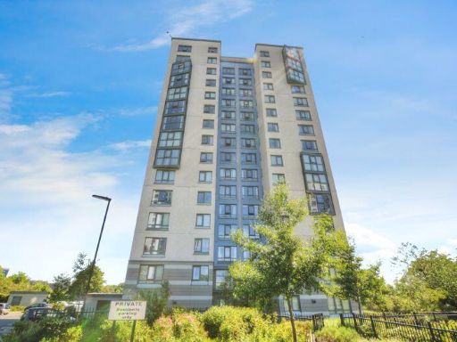 2 bedroom flat for sale in The Cedars, Park Road, Newcastle Upon Tyne, NE4 — £90,000 • 2 bed • 1 bath
 2 bedroom flat for sale in Wills Oval, Newcastle upon Tyne, Tyne and Wear, NE7 — £140,000 • 2 bed • 2 bath • 914 ft²
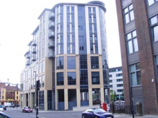 2 bedroom apartment for sale in Waterloo Square, Newcastle Upon Tyne, Tyne & Wear, NE1 — £90,000 • 2 bed • 2 bath • 625 ft²
 2 bedroom apartment for sale in Kirkwood Drive, Kenton, Newcastle Upon Tyne, NE3 — £54,000 • 2 bed • 1 bath • 438 ft²
 2 bedroom apartment for sale in Baltic Quay, Mill Road, Quayside, NE8 — £150,000 • 2 bed • 2 bath • 668 ft²
Meta
- {
"@context": "https://schema.org",
"@type": "Residence",
"name": "2 bedroom apartment for sale in Park Road, The Cedars Park…",
"description": "",
"url": "https://propertypiper.co.uk/property/f494bd5c-432c-405d-a318-b781b771ee81",
"image": "https://image-a.propertypiper.co.uk/0a8a7069-5e20-4ce7-a7c1-0a5f715c2bd6-1024.jpeg",
"address": {
"@type": "PostalAddress",
"streetAddress": "Park Road, The Cedars Park Road, NE4",
"postalCode": "NE4 7DX",
"addressLocality": "Newcastle upon Tyne",
"addressRegion": "Newcastle upon Tyne Central",
"addressCountry": "England"
},
"geo": {
"@type": "GeoCoordinates",
"latitude": 54.9638576,
"longitude": -1.6340467
},
"numberOfRooms": 2,
"numberOfBathroomsTotal": 1,
"floorSize": {
"@type": "QuantitativeValue",
"value": 596,
"unitCode": "FTK"
},
"offers": {
"@type": "Offer",
"price": 55000,
"priceCurrency": "GBP",
"availability": "https://schema.org/InStock"
},
"additionalProperty": [
{
"@type": "PropertyValue",
"name": "Feature",
"value": "apartment"
},
{
"@type": "PropertyValue",
"name": "Feature",
"value": "high-rise"
},
{
"@type": "PropertyValue",
"name": "Feature",
"value": "modern"
},
{
"@type": "PropertyValue",
"name": "Feature",
"value": "urban"
},
{
"@type": "PropertyValue",
"name": "Feature",
"value": "city living"
},
{
"@type": "PropertyValue",
"name": "Feature",
"value": "views"
},
{
"@type": "PropertyValue",
"name": "Feature",
"value": "centrally located"
},
{
"@type": "PropertyValue",
"name": "Feature",
"value": "modern kitchen"
},
{
"@type": "PropertyValue",
"name": "Feature",
"value": "white cabinets"
},
{
"@type": "PropertyValue",
"name": "Feature",
"value": "wood flooring"
},
{
"@type": "PropertyValue",
"name": "Feature",
"value": "small kitchen"
},
{
"@type": "PropertyValue",
"name": "Feature",
"value": "integrated appliances"
}
]
}
High Res Floorplan Images
Compatible Floorplan Images
FloorplanImages Thumbnail