S5 9GD - 3 bedroom detached house for sale in Tunwell Greave, Sheffi…
View on Property Piper
3 bedroom detached house for sale in Tunwell Greave, Sheffield, S5
Property Details
- Price: £260000
- Bedrooms: 3
- Bathrooms: 1
- Property Type: undefined
- Property SubType: undefined
Brochure Descriptions
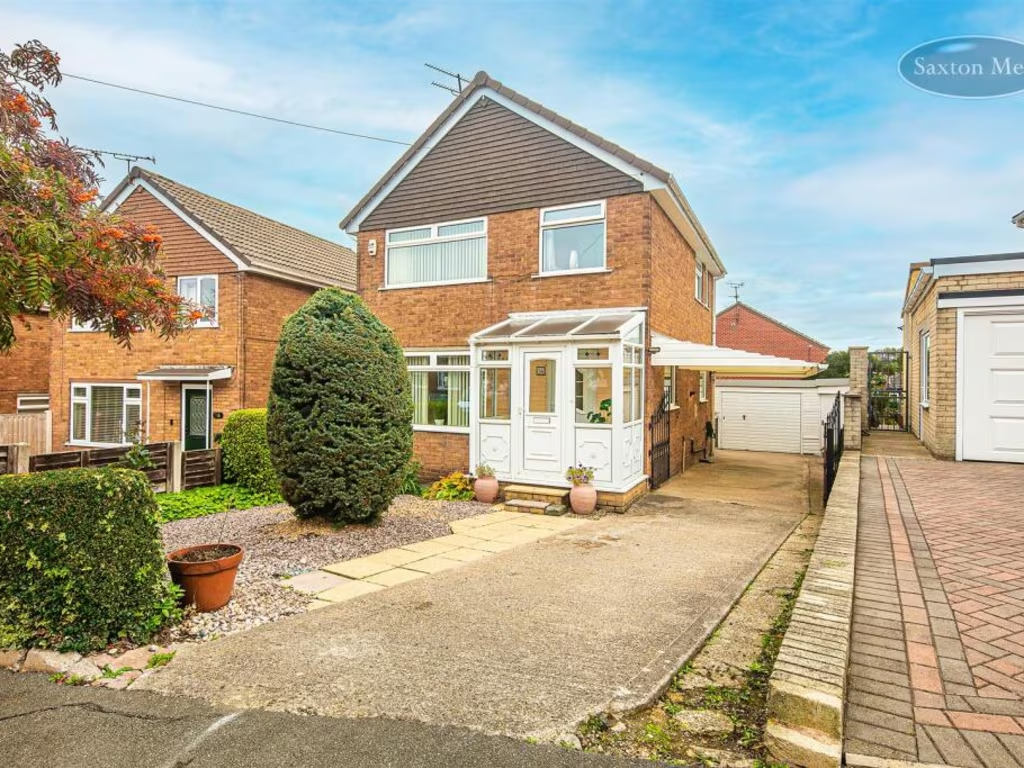
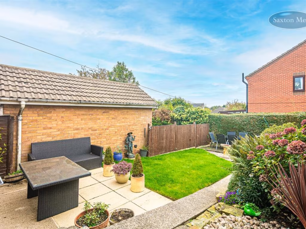
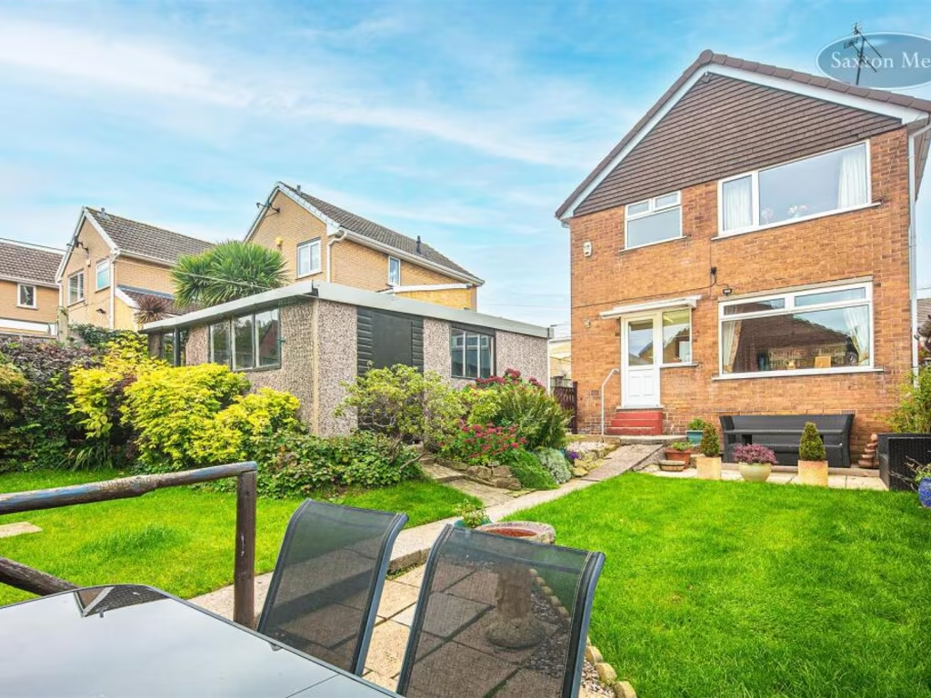
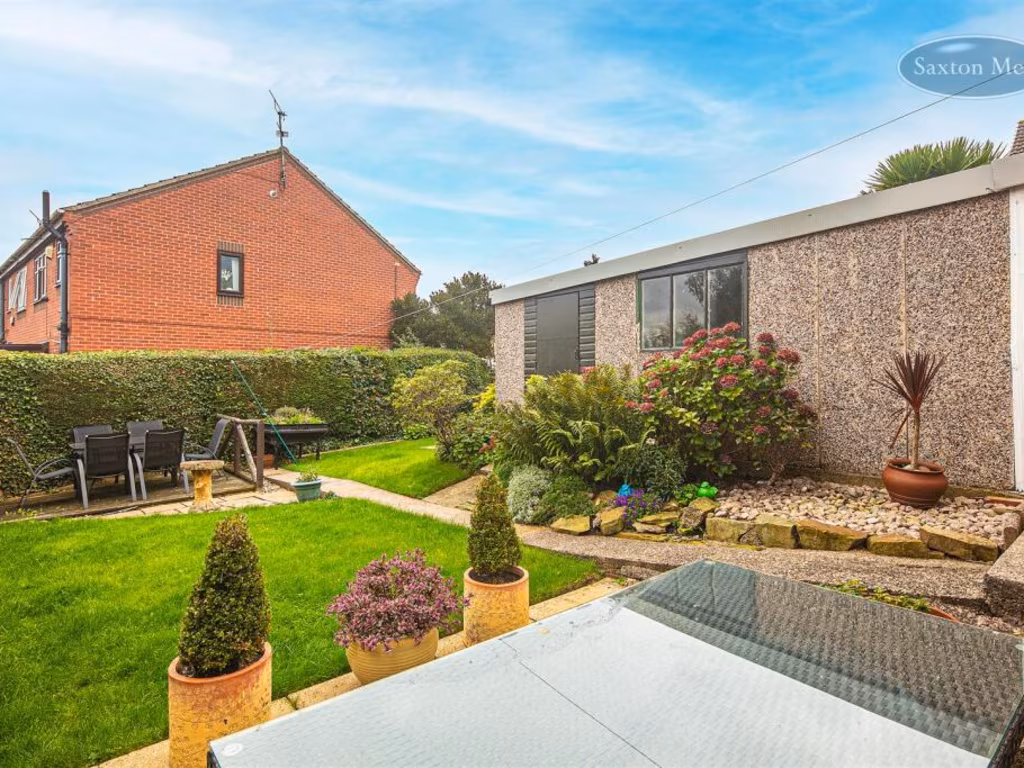
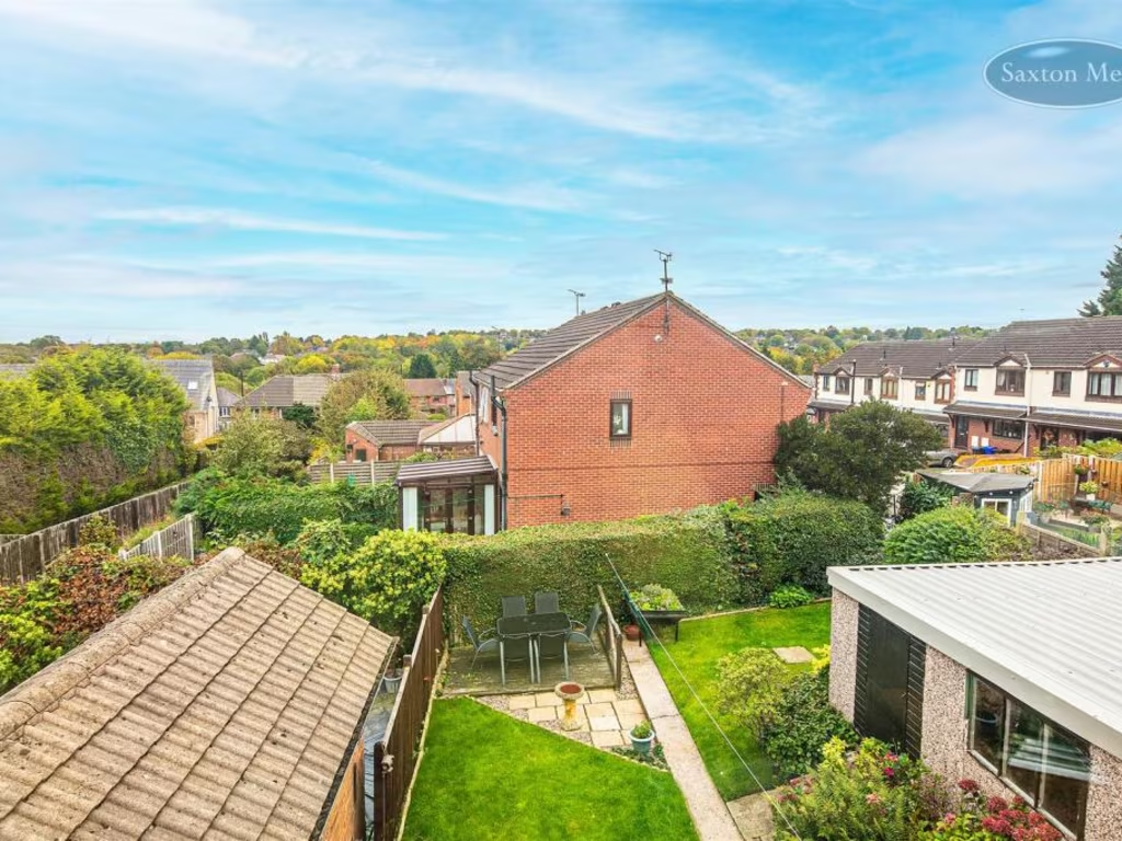
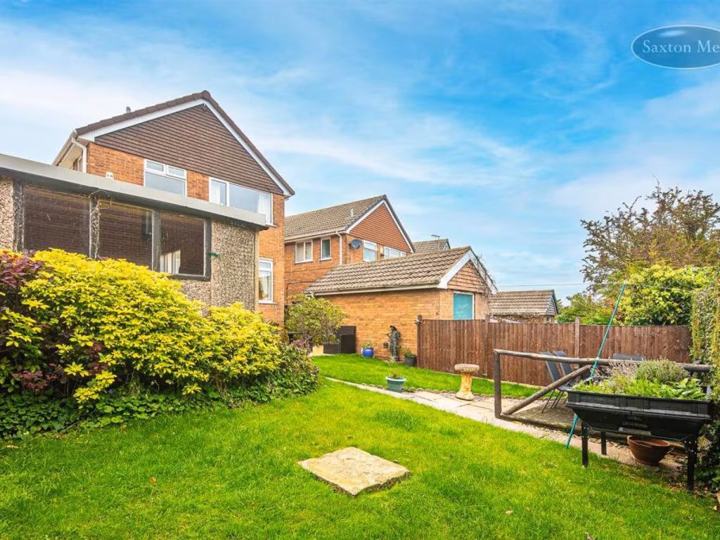
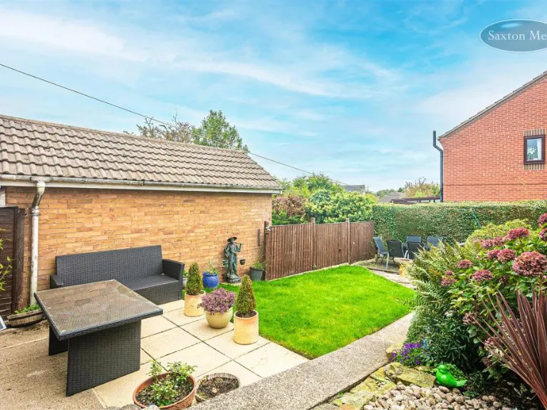
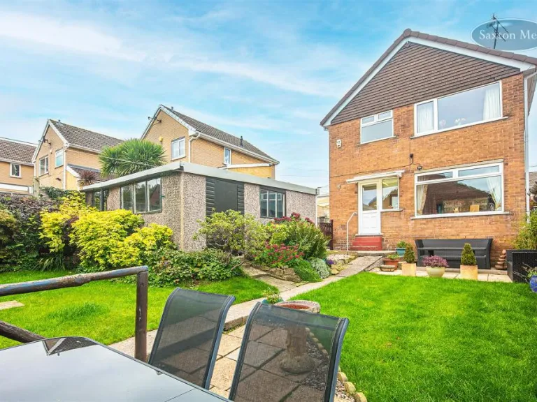
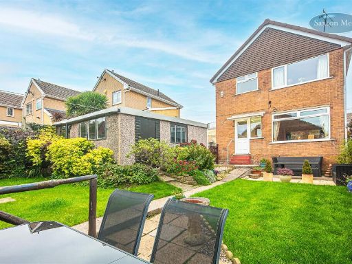
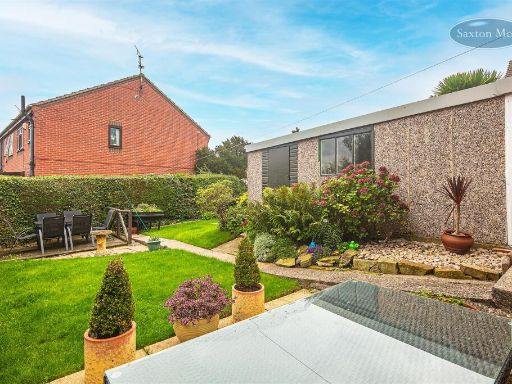
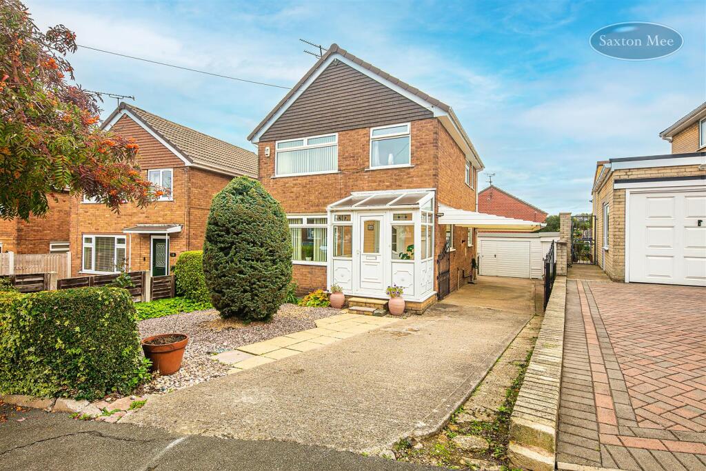
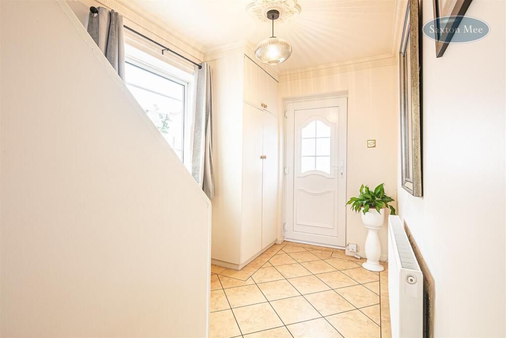
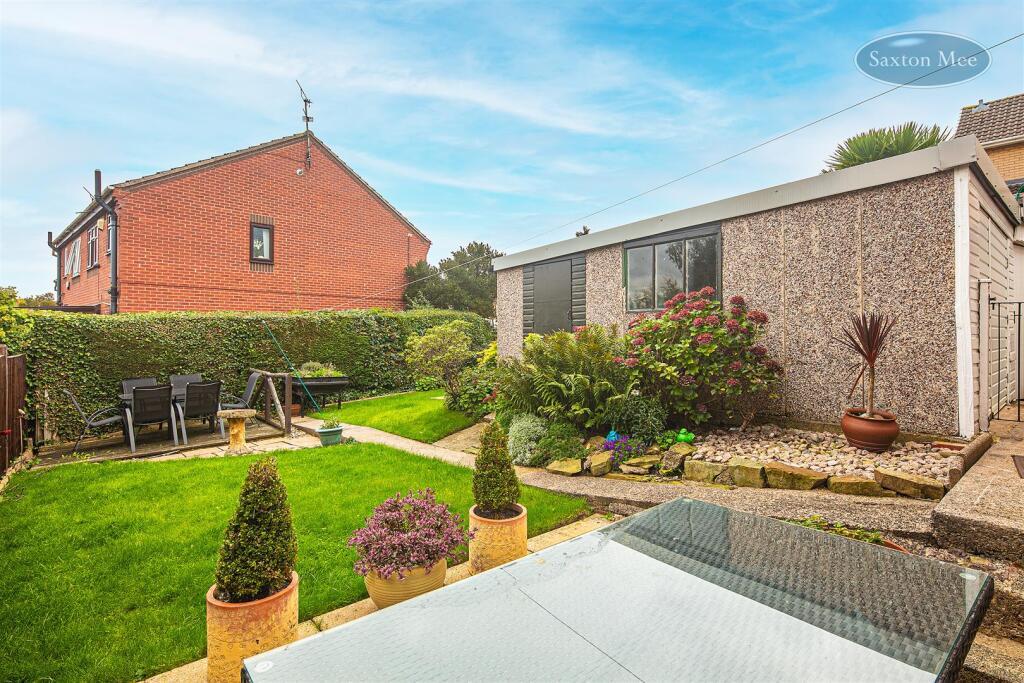
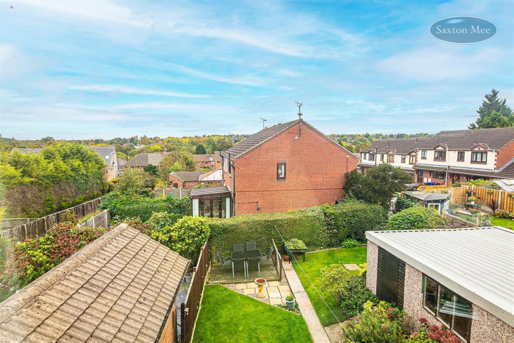
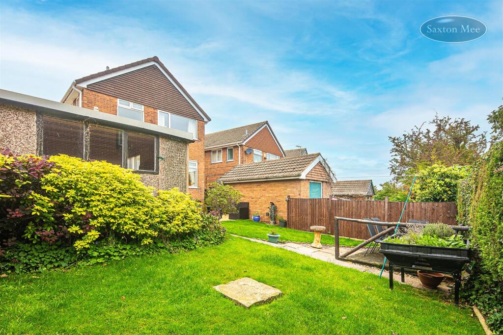
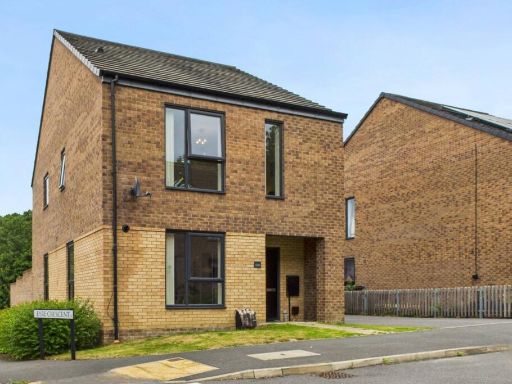
- Detached two-storey brick house in a suburban residential setting. Property features a covered entrance porch, private driveway leading to a single garage, and a paved front area with low-maintenance planting. Rear garden is medium in size with a lawn, patio/seating area and planted borders; overall the garden appears well-maintained and private. The house presents as an average-sized family property with typical 1960s/70s style elevations and uPVC windows/doors. Views are of neighbouring suburban houses and gardens. Overall property footprint and plot size are consistent with an average family dwelling on a residential street.
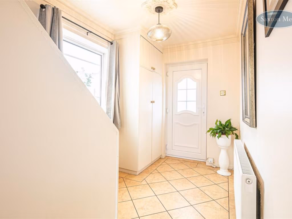
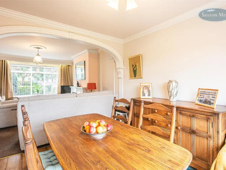
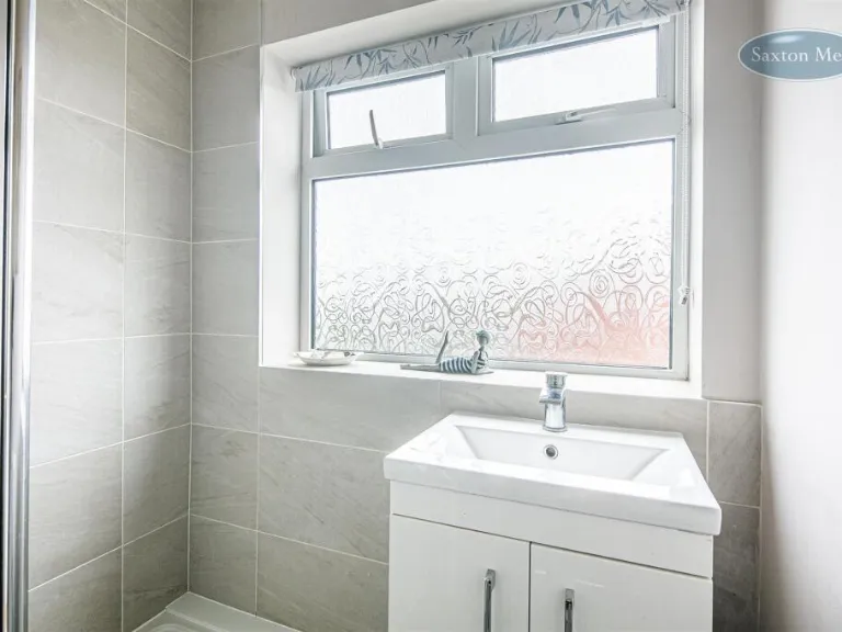
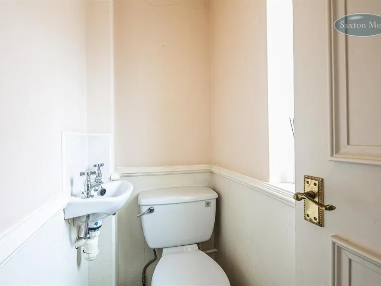
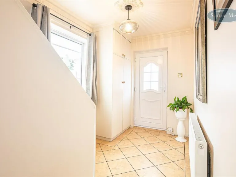
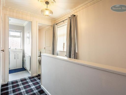
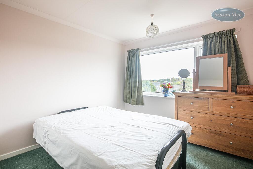
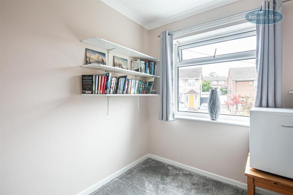
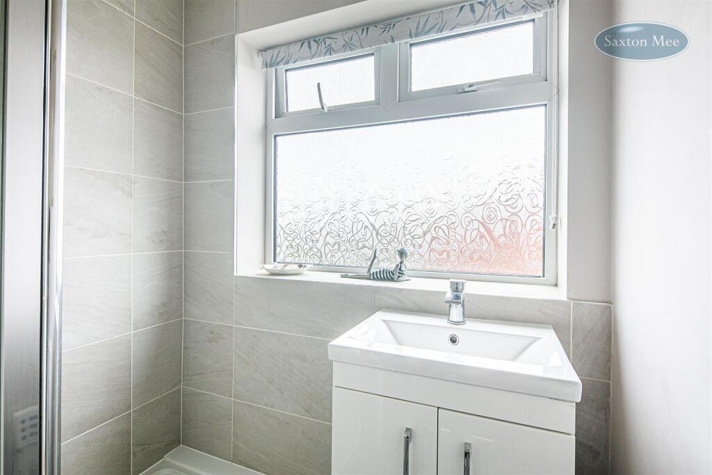
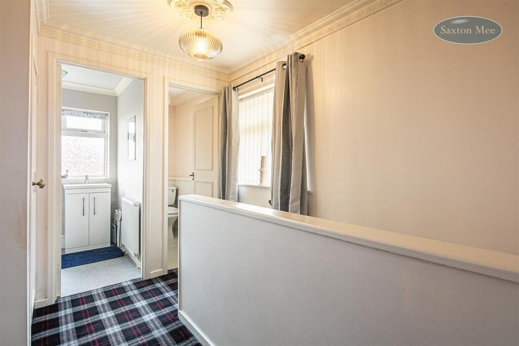
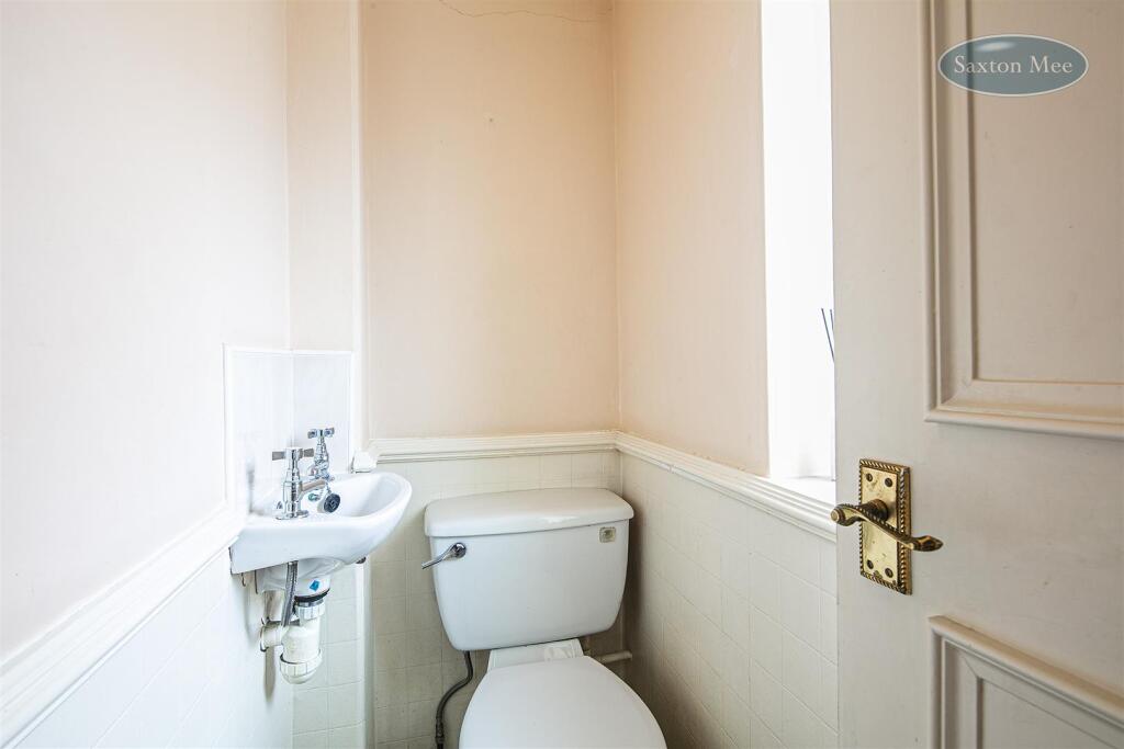
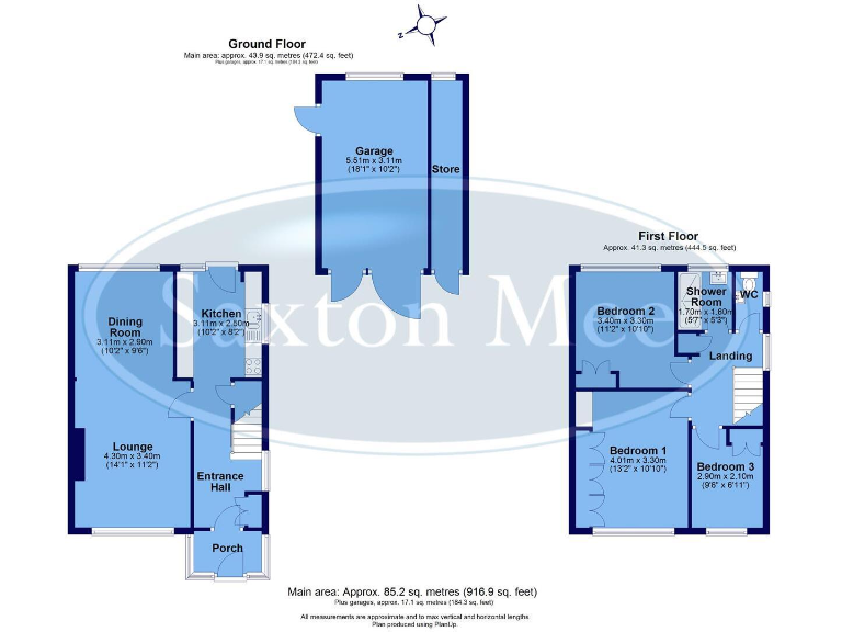
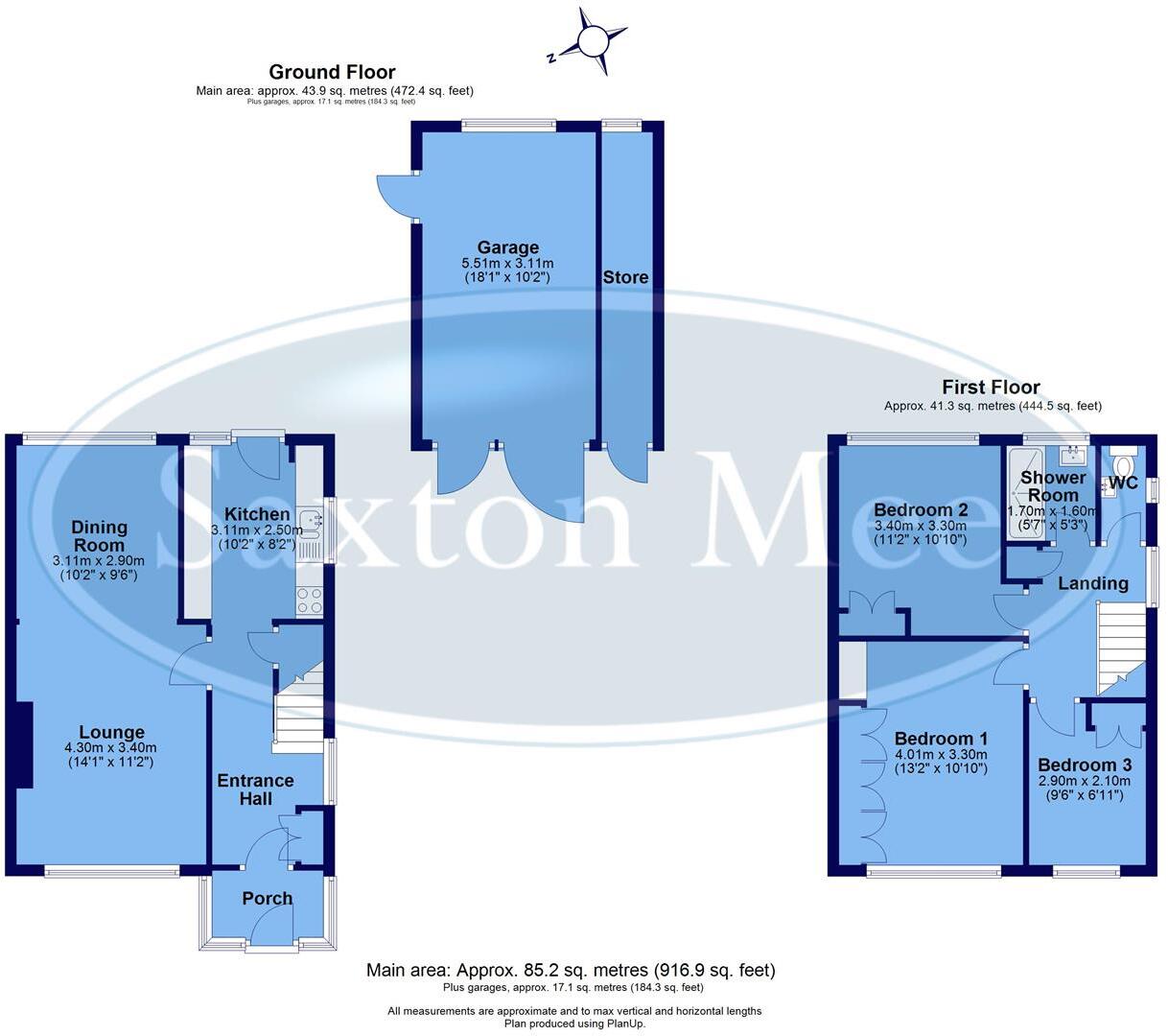
- Two-storey residential dwelling shown as a conventional three-bedroom house with attached garage and separate store. Ground floor layout comprises porch, entrance hall, lounge, dining room and kitchen. First floor comprises three bedrooms (one principal bedroom) and a shower room/WC. Separate garage (with adjacent store) is shown to the rear. The plan indicates a modest-to-medium sized property footprint and no external scenic views are depicted on the plan. Internally the accommodation is practical and compact; room sizes appear average for a three-bedroom family home. Overall the property presents as a medium-sized family house with off-street garaging and storage; suitable for family occupation or as a rental investment.
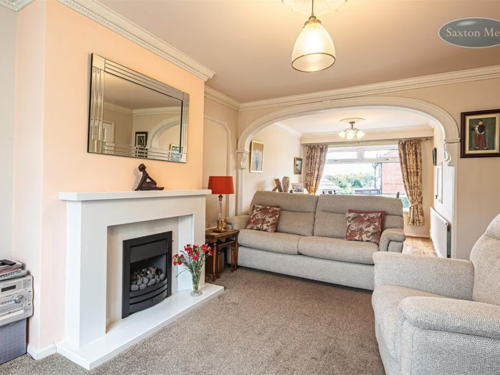
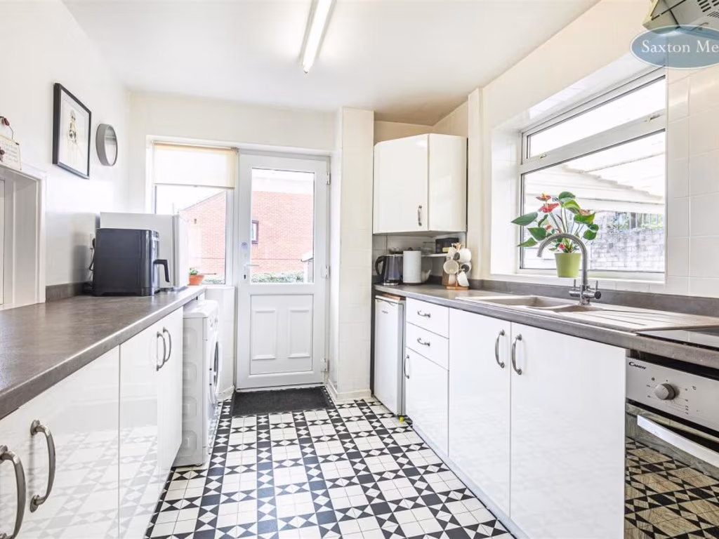
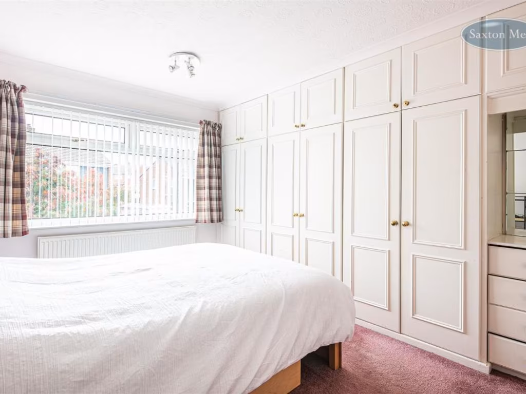
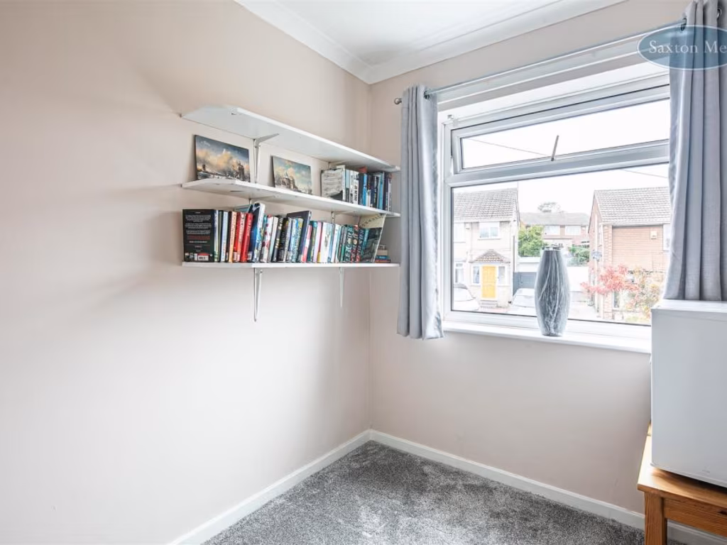
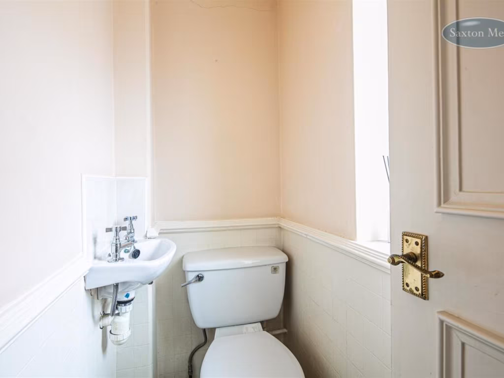
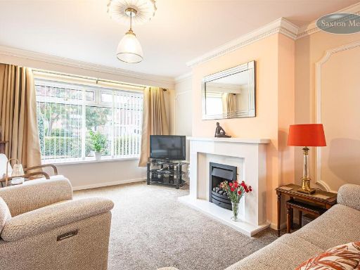
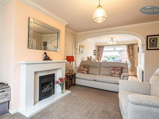
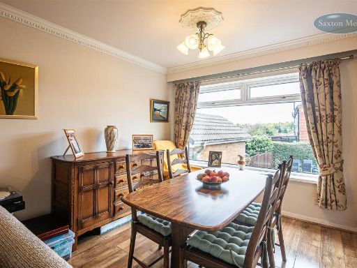
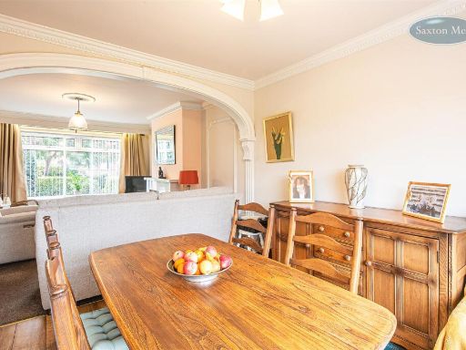
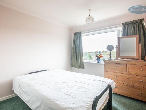
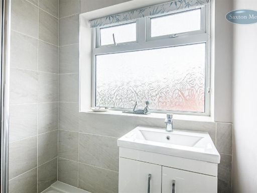
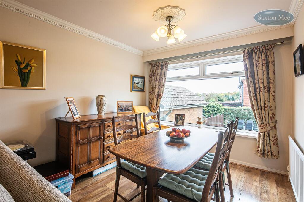
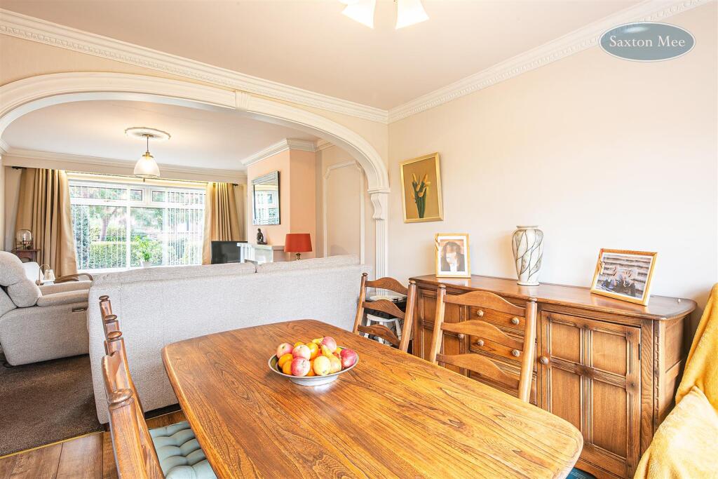
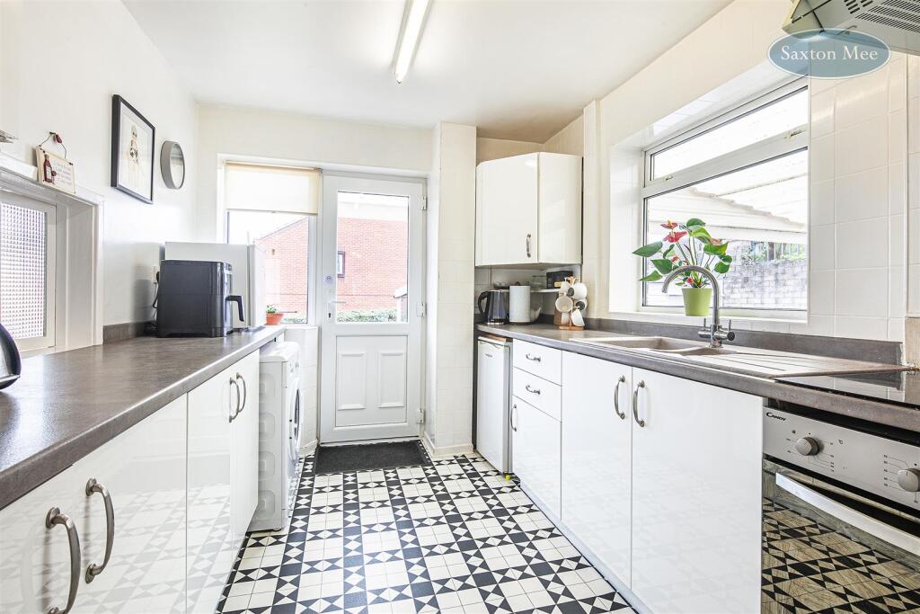
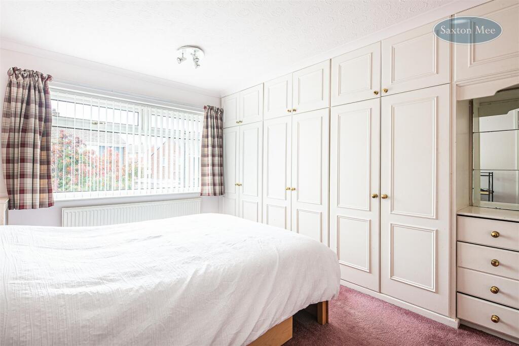
- Three-bedroom detached family house presented in neutral tones. Sitting room and separate open-plan lounge/dining area with large front windows providing good natural light. Separate kitchen; main bedroom with fitted wardrobes, further two bedrooms and ground-floor shower room plus separate WC. Externally there is a fully enclosed south-east facing rear garden, driveway providing off-road parking for two cars and a detached garage/store room. Overall accommodation appears to be of average family home proportions on a tree-lined residential road, offering practical family layout and good onward access to local amenities and motorway links. Garden size: average. Property size: typical for a three-bedroom detached home (not specified).
Image Descriptions
- detached house with driveway and garage 1970s detached
- garden Post-war
Floorplan Description
- Two-storey house floorplan with integral garage and store (garage area excluded).
Rooms
- Dining Room:
- Kitchen:
- Lounge:
- Bedroom 2:
- Bedroom 1:
- Bedroom 3:
- Shower Room:
Textual Property Features
- Has Garden
- Chain Free
- Success
Detected Visual Features
- detached house
- 1970s
- driveway
- garage
- family home
- suburban
- brick exterior
- asphalt roof
- garden
- patio
- lawn
- brick
- post-war
- privacy fence
- low hedge
- garage roof
- outdoor seating
EPC Details
- Fully double glazed
- Cavity wall, as built, no insulation (assumed)
- No system present: electric heaters assumed
- Low energy lighting in 11% of fixed outlets
- Suspended, no insulation (assumed)
Nearby Schools
- Abbeyfield Primary Academy
- Whiteways Primary School
- Owler Brook Primary School
- Southey Green Primary School and Nurseries
- Beck Primary School
- Monteney Primary School
- St Thomas More Catholic Primary, A Voluntary Academy
- Oasis Academy Fir Vale
- Parkwood E-ACT Academy
- St Patrick's Catholic Voluntary Academy
- Firth Park Academy
- Chaucer School
- Mansel Primary
- Ecclesfield Primary School
- Coit Primary School
- St Catherine's Catholic Primary School (Hallam)
- Fir Vale School
- Watercliffe Meadow Community Primary School
- E-ACT Pathways Academy
- Hatfield Academy
- Oasis Academy Watermead
- Hucklow Primary School
- Hinde House 2-16 Academy
- Meynell Community Primary School
- Hartley Brook Primary School
- Yewlands Academy
- Ecclesfield School
- Windmill Hill Primary School
Nearest General Shops
- Id: 144345795
- Tags:
- Building: yes
- Name: Job Lot Cash & Carry
- Shop: yes
- Source: Bing
- TagsNormalized:
- Lat: 53.4263835
- Lon: -1.4573557
- FullGeoHash: gcqzyvfz1psz
- PartitionGeoHash: gcqz
- Images:
- FoodStandards: null
- Distance: 711
,- Id: 278608474
- Tags:
- Name: A. J. Hurdley
- Shop: optician
- TagsNormalized:
- Lat: 53.4361993
- Lon: -1.4583573
- FullGeoHash: gcqzyzf03v9c
- PartitionGeoHash: gcqz
- Images:
- FoodStandards: null
- Distance: 414.7
,- Id: 9806987489
- Tags:
- Old_name: The High Greave
- Shop: funeral_directors
- TagsNormalized:
- funeral
- funeral directors
- shop
- Lat: 53.434075
- Lon: -1.4581776
- FullGeoHash: gcqzyz6hjcxc
- PartitionGeoHash: gcqz
- Images:
- FoodStandards: null
- Distance: 202
}
Nearest Supermarkets
- Id: 711109365
- Tags:
- Brand: Farmfoods
- Brand:wikidata: Q5435841
- Brand:wikipedia: en:Farmfoods
- Building: supermarket
- Contact:
- Website: https://www.farmfoods.co.uk/store-finder.php?branch_code=453
- Name: Farmfoods
- Opening_hours:
- Url: https://www.farmfoods.co.uk/store-finder.php?branch_code=453
- Shop: frozen_food
- TagsNormalized:
- farmfoods
- supermarket
- frozen food
- food
- shop
- Lat: 53.4277963
- Lon: -1.4851895
- FullGeoHash: gcqzynnx2x47
- PartitionGeoHash: gcqz
- Images:
- FoodStandards: null
- Distance: 1756
,- Id: 670901424
- Tags:
- Addr:
- City: Sheffield
- Housenumber: 82
- Postcode: S35 9WN
- Street: The Common
- Brand: ALDI
- Brand:wikidata: Q41171672
- Brand:wikipedia: en:Aldi
- Building: yes
- Contact:
- Website: https://stores.aldi.co.uk/ecclesfield/82-the-common
- Fhrs:
- Name: Aldi
- Shop: supermarket
- TagsNormalized:
- Lat: 53.4457803
- Lon: -1.4638579
- FullGeoHash: gcwbn9w01xs3
- PartitionGeoHash: gcwb
- Images:
- FoodStandards:
- Id: 650952
- FHRSID: 650952
- LocalAuthorityBusinessID: 40015
- BusinessName: Aldi Stores Ltd
- BusinessType: Retailers - supermarkets/hypermarkets
- BusinessTypeID: 7840
- AddressLine1: null
- AddressLine2: 82 The Common
- AddressLine3: Sheffield
- AddressLine4: null
- PostCode: S35 9WN
- RatingValue: 5
- RatingKey: fhrs_5_en-GB
- RatingDate: 2019-12-10
- LocalAuthorityCode: 425
- LocalAuthorityName: Sheffield
- LocalAuthorityWebSite: https://www.sheffield.gov.uk
- LocalAuthorityEmailAddress: healthprotection@sheffield.gov.uk
- Scores:
- Hygiene: 0
- Structural: 0
- ConfidenceInManagement: 0
- NewRatingPending: false
- Geocode:
- Longitude: -1.46153500000000
- Latitude: 53.44413800000000
- Distance: 1489.6
,- Id: 72639164
- Tags:
- Brand: Morrisons
- Brand:wikidata: Q922344
- Brand:wikipedia: en:Morrisons
- Building: yes
- Contact:
- Website: https://my.morrisons.com/storefinder/72
- Name: Morrisons
- Opening_hours: Mo-Sa 07:00-22:00; Su 10:00-16:00
- Shop: supermarket
- Source: OS OpenData StreetView
- Wheelchair: yes
- TagsNormalized:
- Lat: 53.4441329
- Lon: -1.459133
- FullGeoHash: gcwbnc1qxsrw
- PartitionGeoHash: gcwb
- Images:
- FoodStandards: null
- Distance: 1284.6
}
Nearest Religious buildings
- Id: 147586104
- Tags:
- Amenity: place_of_worship
- Building: yes
- Religion: jewish
- Source: Bing
- TagsNormalized:
- place of worship
- jewish
- synagogue
- Lat: 53.4298188
- Lon: -1.4636829
- FullGeoHash: gcqzyww5m8ng
- PartitionGeoHash: gcqz
- Images:
- FoodStandards: null
- Distance: 395.7
,- Id: 265054
- Tags:
- Name: Ecclesfield - Highgreave Church
- Naptan:
- StopAreaCode: 370G100045
- StopAreaType: GPBS
- Verified: no
- Public_transport: stop_area
- Site: stop_area
- Source: naptan_import
- Type: public_transport
- TagsNormalized:
- Lat: 53.432345
- Lon: -1.4582526
- FullGeoHash: gcqzyz41ur01
- PartitionGeoHash: gcqz
- Images:
- FoodStandards: null
- Distance: 114.7
,- Id: 278608484
- Tags:
- Amenity: place_of_worship
- Religion: christian
- TagsNormalized:
- place of worship
- christian
- church
- Lat: 53.4327845
- Lon: -1.4583032
- FullGeoHash: gcqzyz4he0fq
- PartitionGeoHash: gcqz
- Images:
- FoodStandards: null
- Distance: 110.2
}
Nearest Medical buildings
- Id: 148351646
- Tags:
- Addr:
- City: Sheffield
- Housenumber: 1
- Postcode: S5 9PA
- Street: Remington Avenue
- Amenity: doctors
- Building: yes
- Healthcare: doctor
- Name: Ecclesfield Group Practice
- Source: Bing
- TagsNormalized:
- doctor
- doctors
- health
- healthcare
- Lat: 53.4319201
- Lon: -1.4778271
- FullGeoHash: gcqzyqgzkpu4
- PartitionGeoHash: gcqz
- Images:
- FoodStandards: null
- Distance: 1187.6
,- Id: 10133721341
- Tags:
- Amenity: pharmacy
- Healthcare: pharmacy
- Name: Numark
- TagsNormalized:
- Lat: 53.4225022
- Lon: -1.4554123
- FullGeoHash: gcqzyvk0wkjy
- PartitionGeoHash: gcqz
- Images:
- FoodStandards: null
- Distance: 1161
,- Id: 305646320
- Tags:
- TagsNormalized:
- Lat: 53.4355322
- Lon: -1.4485987
- FullGeoHash: gcqzzp9ht1nt
- PartitionGeoHash: gcqz
- Images:
- FoodStandards: null
- Distance: 819.1
,- Id: 278605395
- Tags:
- Amenity: doctors
- Name: Park Dental Care
- TagsNormalized:
- Lat: 53.4317416
- Lon: -1.4584726
- FullGeoHash: gcqzyycyrns1
- PartitionGeoHash: gcqz
- Images:
- FoodStandards: null
- Distance: 135.2
}
Nearest Leisure Facilities
- Id: 149675750
- Tags:
- Leisure: common
- Source: Bing
- TagsNormalized:
- Lat: 53.4333917
- Lon: -1.4540234
- FullGeoHash: gcqzyzm0nf1t
- PartitionGeoHash: gcqz
- Images:
- FoodStandards: null
- Distance: 401.6
,- Id: 144345248
- Tags:
- Leisure: common
- Source: Bing
- TagsNormalized:
- Lat: 53.4290468
- Lon: -1.4607069
- FullGeoHash: gcqzyy2qg01y
- PartitionGeoHash: gcqz
- Images:
- FoodStandards: null
- Distance: 397.3
,- Id: 25561515
- Tags:
- TagsNormalized:
- Lat: 53.4325716
- Lon: -1.465708
- FullGeoHash: gcqzyxheq92b
- PartitionGeoHash: gcqz
- Images:
- FoodStandards: null
- Distance: 382.5
,- Id: 25561510
- Tags:
- TagsNormalized:
- Lat: 53.4329184
- Lon: -1.4630913
- FullGeoHash: gcqzyxnt79bj
- PartitionGeoHash: gcqz
- Images:
- FoodStandards: null
- Distance: 212.3
,- Id: 25561512
- Tags:
- Leisure: pitch
- Source: Bing
- Sport: soccer
- TagsNormalized:
- Lat: 53.4326207
- Lon: -1.4626574
- FullGeoHash: gcqzyxngtd7t
- PartitionGeoHash: gcqz
- Images:
- FoodStandards: null
- Distance: 180.4
}
Nearest Tourist attractions
- Id: 9057481511
- Tags:
- Addr:
- City: Sheffield
- Country: GB
- Housenumber: 949
- Postcode: S4 8ES
- Street: Grimesthorpe Road
- Fhrs:
- Name: Earl Marshall Guest House
- Tourism: guest_house
- TagsNormalized:
- Lat: 53.4059033
- Lon: -1.4388297
- FullGeoHash: gcqzz60rbvfy
- PartitionGeoHash: gcqz
- Images:
- FoodStandards:
- Id: 435704
- FHRSID: 435704
- LocalAuthorityBusinessID: 17001
- BusinessName: Earl Marshall Guest House
- BusinessType: Hotel/bed & breakfast/guest house
- BusinessTypeID: 7842
- AddressLine1: null
- AddressLine2: 949 Grimesthorpe Road
- AddressLine3: Sheffield
- AddressLine4: null
- PostCode: S4 8ES
- RatingValue: 5
- RatingKey: fhrs_5_en-GB
- RatingDate: 2016-02-13
- LocalAuthorityCode: 425
- LocalAuthorityName: Sheffield
- LocalAuthorityWebSite: https://www.sheffield.gov.uk
- LocalAuthorityEmailAddress: healthprotection@sheffield.gov.uk
- Scores:
- Hygiene: 0
- Structural: 0
- ConfidenceInManagement: 0
- NewRatingPending: false
- Geocode:
- Longitude: -1.43847400000000
- Latitude: 53.40610000000000
- Distance: 3280.5
,- Id: 8378786857
- Tags:
- TagsNormalized:
- Lat: 53.4136576
- Lon: -1.444523
- FullGeoHash: gcqzz5sjh5mw
- PartitionGeoHash: gcqz
- Images:
- FoodStandards: null
- Distance: 2339.8
,- Id: 9707412017
- Tags:
- Name: The Wharncliffe
- Tourism: apartment
- TagsNormalized:
- Lat: 53.4188794
- Lon: -1.4460462
- FullGeoHash: gcqzzhe588vg
- PartitionGeoHash: gcqz
- Images:
- FoodStandards: null
- Distance: 1780.7
}
Nearest Hotels
- Id: 289488143
- Tags:
- Name: Firth Park Hotel
- Tourism: hotel
- TagsNormalized:
- Lat: 53.4079907
- Lon: -1.4447577
- FullGeoHash: gcqzz4eunend
- PartitionGeoHash: gcqz
- Images:
- FoodStandards: null
- Distance: 2914.3
,- Id: 127721126
- Tags:
- Addr:
- City: Sheffield
- Housenumber: 72
- Postcode: S9 1LQ
- Street: Newman Road
- Amenity: pub
- Building: yes
- Fhrs:
- Name: Wincobank Hotel
- Source: Bing
- TagsNormalized:
- Lat: 53.4207542
- Lon: -1.4208565
- FullGeoHash: gcqzzsvq7wke
- PartitionGeoHash: gcqz
- Images:
- FoodStandards: null
- Distance: 2904.4
,- Id: 81135568
- Tags:
- Addr:
- City: Sheffield
- Postcode: S35 8NR
- Street: Elliot Lane
- Building: yes
- Fhrs:
- Internet_access: yes
- Internet_access:fee: no
- Name: Whitley Hall Hotel
- Rooms: 32
- Source: OS OpenData StreetView
- Tourism: hotel
- Wikidata: Q7996568
- Wikipedia: en:Whitley Hall
- TagsNormalized:
- Lat: 53.4495689
- Lon: -1.4818737
- FullGeoHash: gcwbn60ymcfc
- PartitionGeoHash: gcwb
- Images:
- FoodStandards: null
- Distance: 2382.4
}
Tags
- detached house
- 1970s
- driveway
- garage
- family home
- suburban
- brick exterior
- asphalt roof
- garden
- patio
- lawn
- brick
- post-war
- privacy fence
- low hedge
- garage roof
- outdoor seating
Local Market Stats
- Average Price/sqft: £164
- Avg Income: £30700
- Rental Yield: 6.7%
- Social Housing: 39%
- Planning Success Rate: 84%
Similar Properties
 3 bedroom detached house for sale in Park Grange Drive, Norfolk Park. S2 3BR , S2 — £340,000 • 3 bed • 2 bath • 1203 ft²
 4 bedroom detached house for sale in Milden Road, Sheffield, S6 — £450,000 • 4 bed • 1 bath • 1638 ft²
 3 bedroom detached house for sale in Darnbrook Drive, Sheffield, South Yorkshire, S5 — £255,000 • 3 bed • 2 bath • 956 ft²
 3 bedroom semi-detached house for sale in Farview Road, Sheffield Lane Top, S5 — £220,000 • 3 bed • 1 bath • 827 ft²
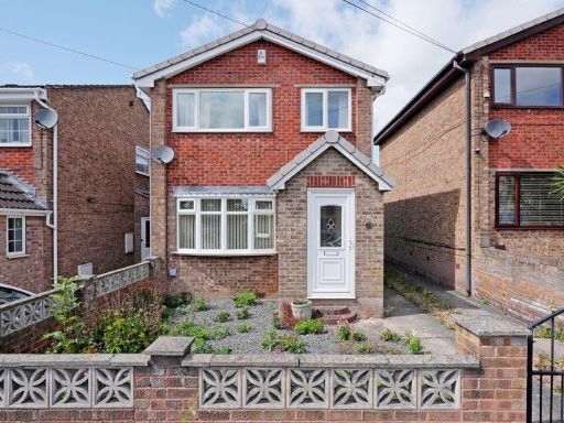 3 bedroom detached house for sale in Parsley Hay Road, Handsworth, Sheffield, S13 — £235,000 • 3 bed • 1 bath • 789 ft²
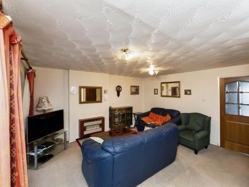 3 bedroom detached house for sale in Chapel Road, Sheffield, S35 — £235,000 • 3 bed • 1 bath • 1067 ft²
Meta
- {
"@context": "https://schema.org",
"@type": "Residence",
"name": "3 bedroom detached house for sale in Tunwell Greave, Sheffi…",
"description": "",
"url": "https://propertypiper.co.uk/property/f19c736c-a18d-4feb-84d5-ba5b1ea3ada1",
"image": "https://image-a.propertypiper.co.uk/f5877431-0177-4183-83aa-d15393169b4a-1024.jpeg",
"address": {
"@type": "PostalAddress",
"streetAddress": "64 TUNWELL GREAVE, SHEFFIELD",
"postalCode": "S5 9GD",
"addressLocality": "Sheffield",
"addressRegion": "Penistone and Stocksbridge",
"addressCountry": "England"
},
"geo": {
"@type": "GeoCoordinates",
"latitude": 53.4325898519007,
"longitude": -1.4599348502095233
},
"numberOfRooms": 3,
"numberOfBathroomsTotal": 1,
"floorSize": {
"@type": "QuantitativeValue",
"value": 916,
"unitCode": "FTK"
},
"offers": {
"@type": "Offer",
"price": 260000,
"priceCurrency": "GBP",
"availability": "https://schema.org/InStock"
},
"additionalProperty": [
{
"@type": "PropertyValue",
"name": "Feature",
"value": "detached house"
},
{
"@type": "PropertyValue",
"name": "Feature",
"value": "1970s"
},
{
"@type": "PropertyValue",
"name": "Feature",
"value": "driveway"
},
{
"@type": "PropertyValue",
"name": "Feature",
"value": "garage"
},
{
"@type": "PropertyValue",
"name": "Feature",
"value": "family home"
},
{
"@type": "PropertyValue",
"name": "Feature",
"value": "suburban"
},
{
"@type": "PropertyValue",
"name": "Feature",
"value": "brick exterior"
},
{
"@type": "PropertyValue",
"name": "Feature",
"value": "asphalt roof"
},
{
"@type": "PropertyValue",
"name": "Feature",
"value": "garden"
},
{
"@type": "PropertyValue",
"name": "Feature",
"value": "patio"
},
{
"@type": "PropertyValue",
"name": "Feature",
"value": "lawn"
},
{
"@type": "PropertyValue",
"name": "Feature",
"value": "brick"
},
{
"@type": "PropertyValue",
"name": "Feature",
"value": "post-war"
},
{
"@type": "PropertyValue",
"name": "Feature",
"value": "privacy fence"
},
{
"@type": "PropertyValue",
"name": "Feature",
"value": "low hedge"
},
{
"@type": "PropertyValue",
"name": "Feature",
"value": "garage roof"
},
{
"@type": "PropertyValue",
"name": "Feature",
"value": "outdoor seating"
}
]
}
High Res Floorplan Images
Compatible Floorplan Images
FloorplanImages Thumbnail