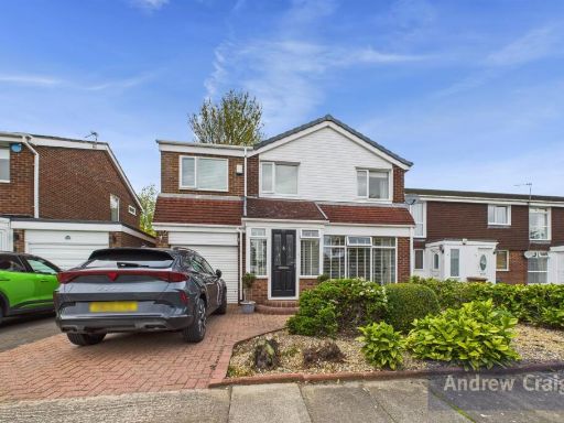
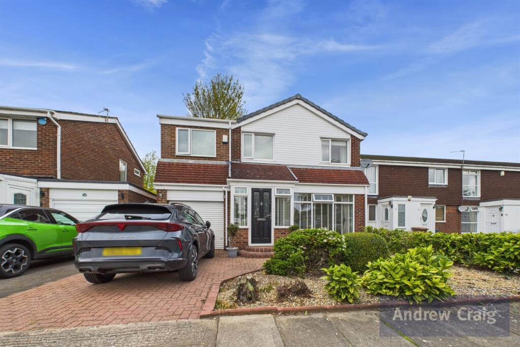
SR3 2RR - 4 bedroom detached house for sale in Manston Close, Moorsid…
View on Property Piper
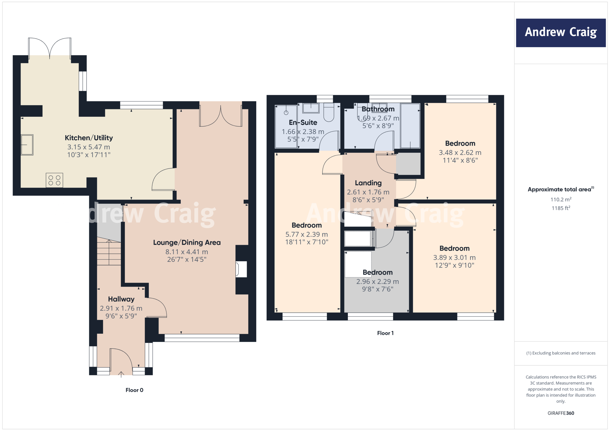
4 bedroom detached house for sale in Manston Close, Moorside, Sunderland, SR3
Property Details
- Price: £275000
- Bedrooms: 4
- Bathrooms: 2
- Property Type: undefined
- Property SubType: undefined
Image Descriptions
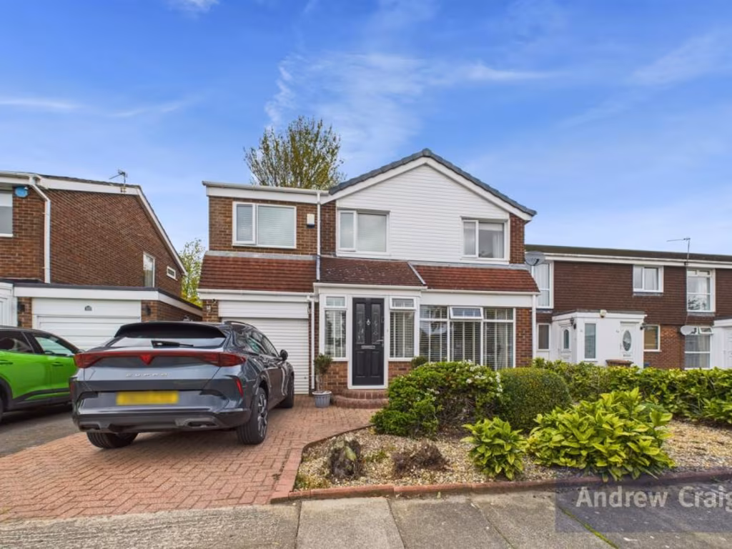
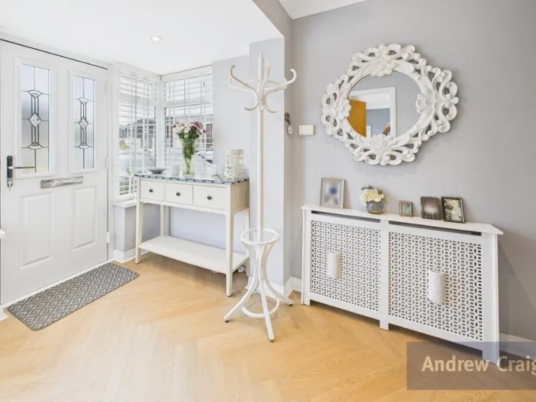
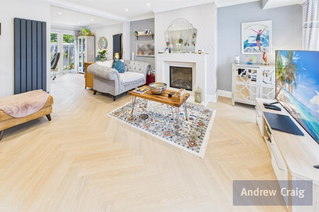
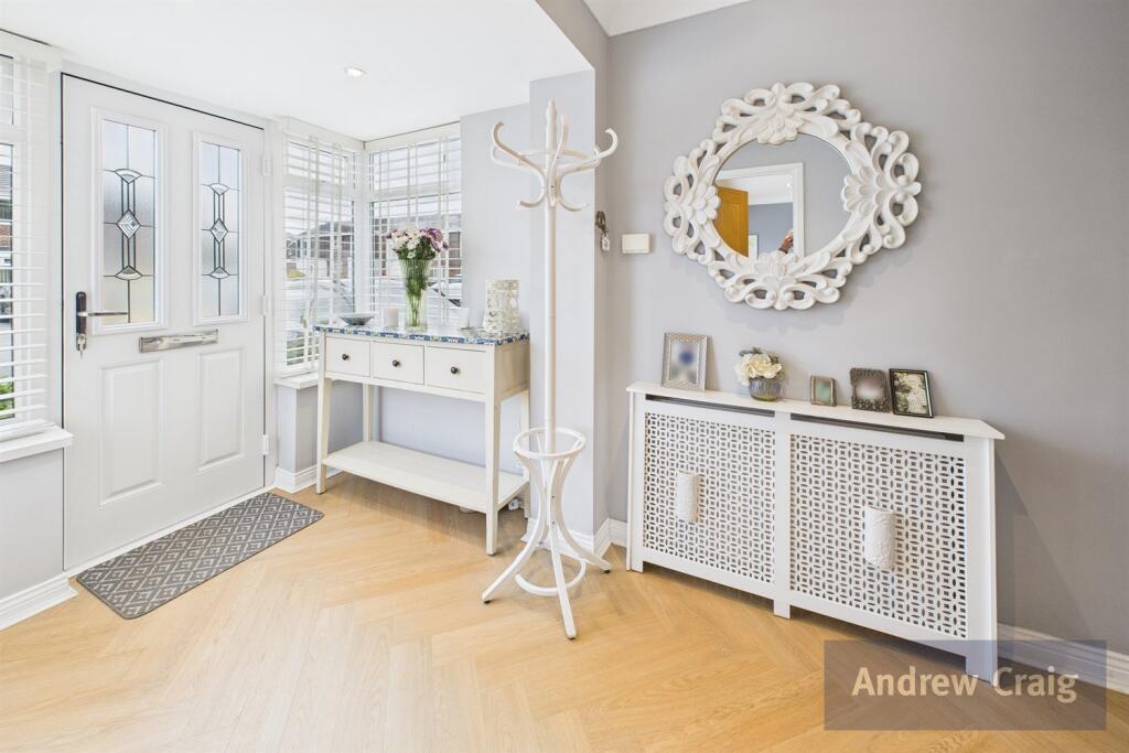
- detached house modern
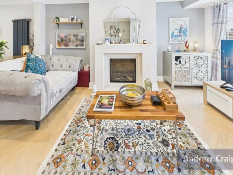
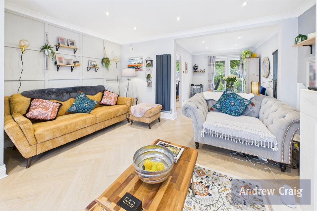
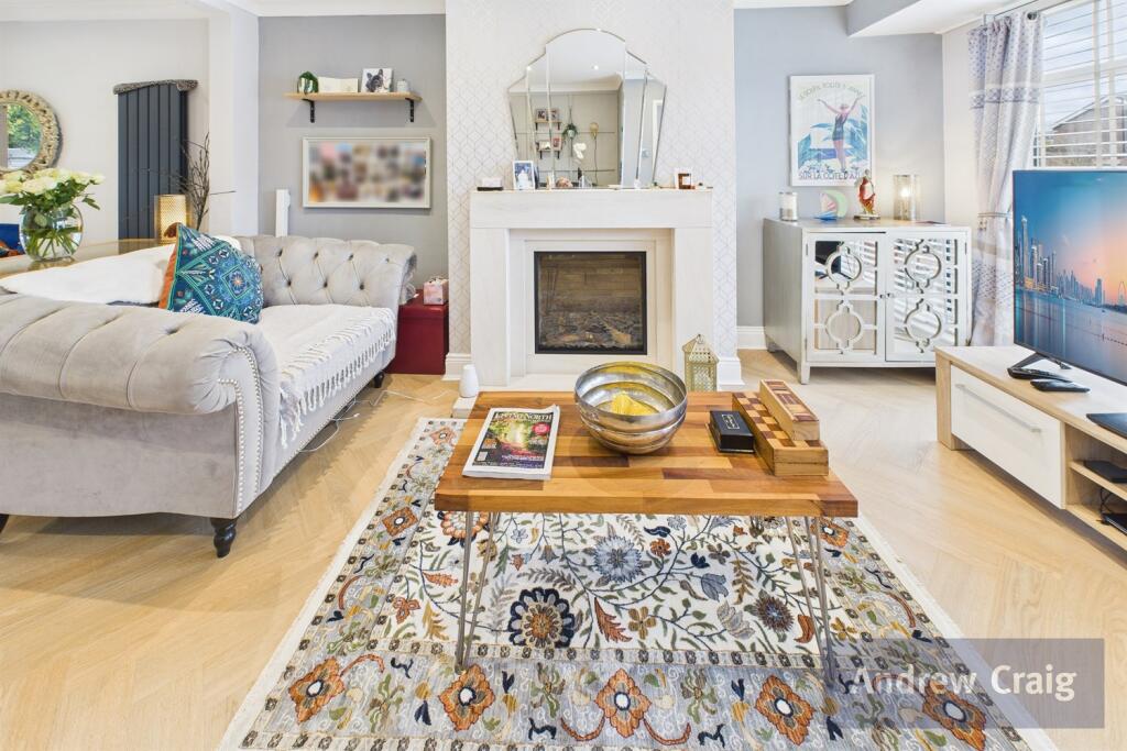
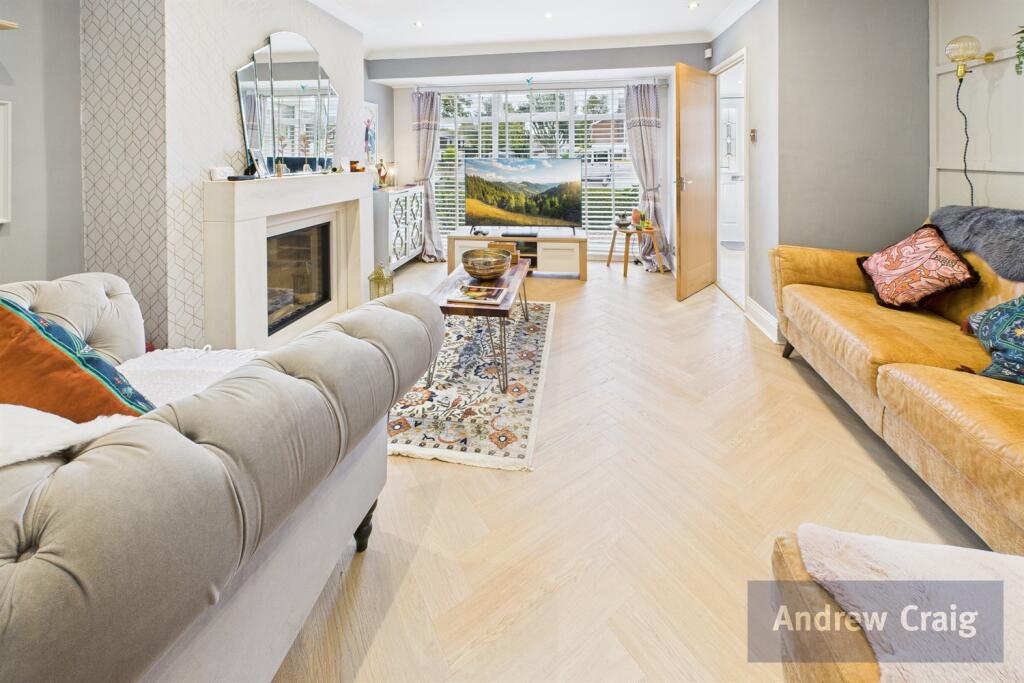
- living room modern
Rooms
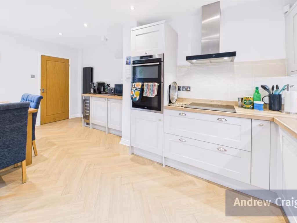
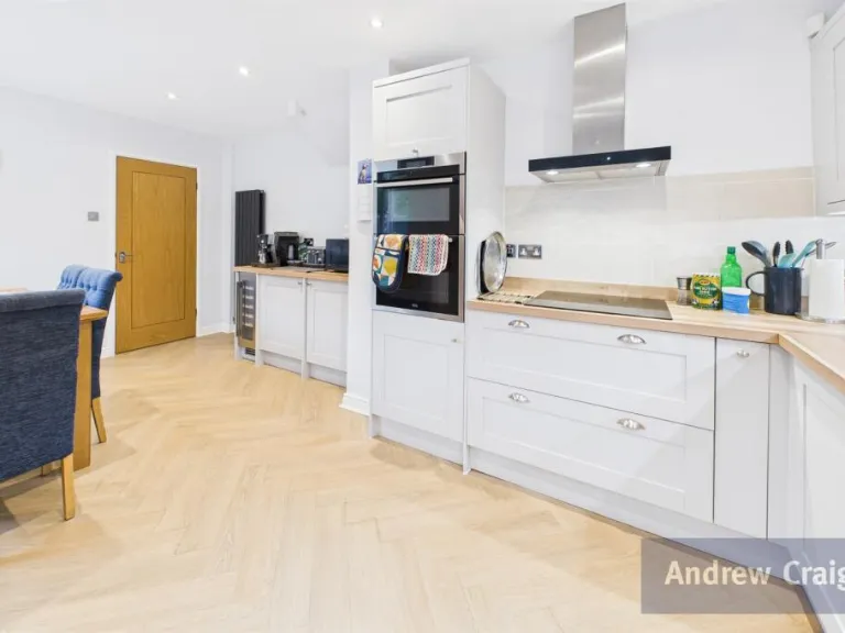
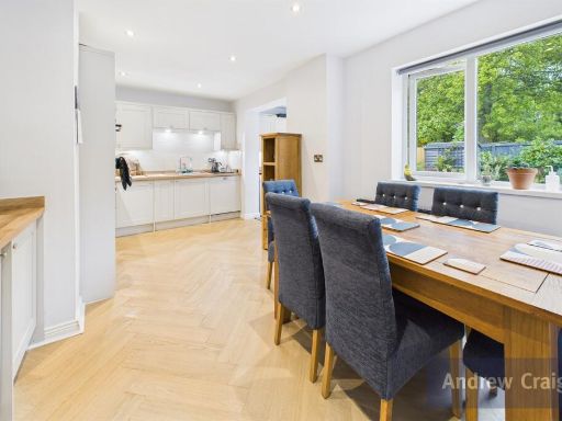
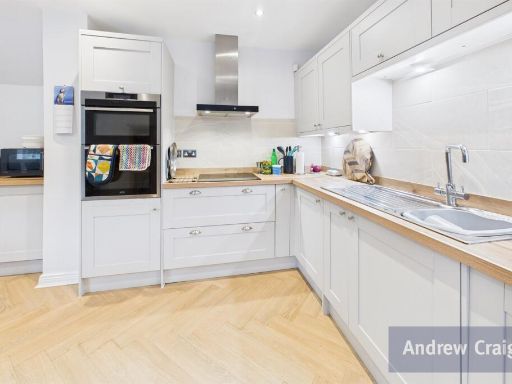
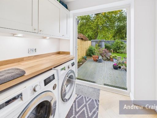
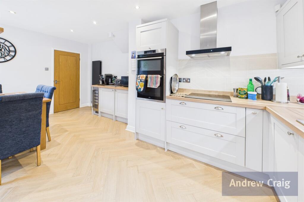
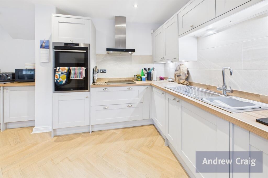
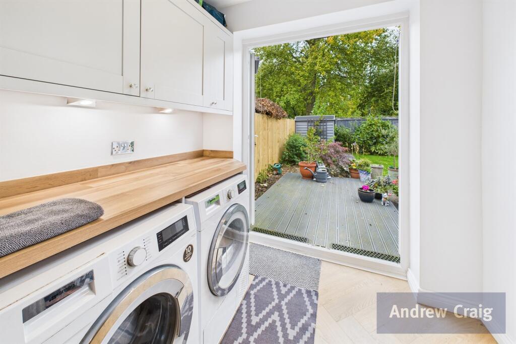
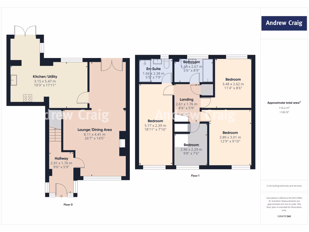
- Kitchen/Utility:
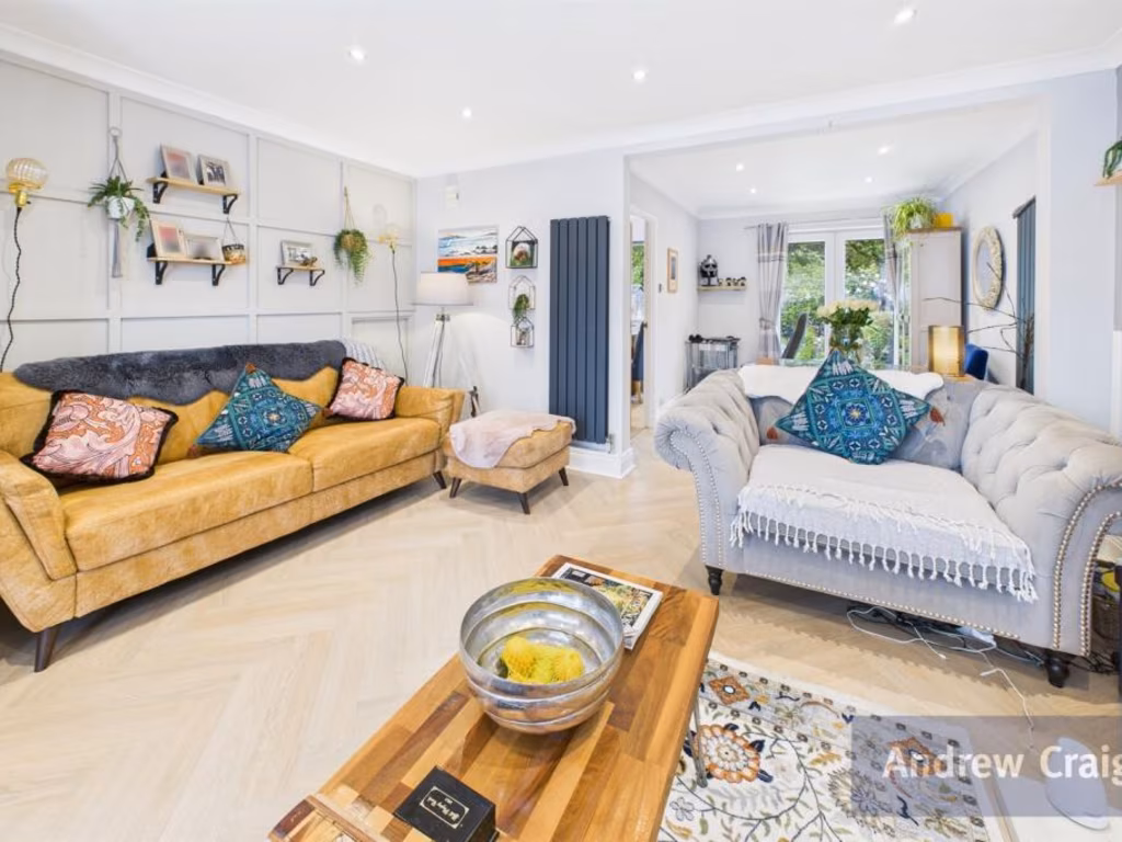
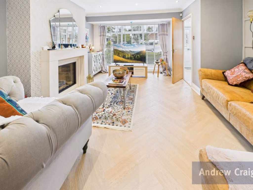
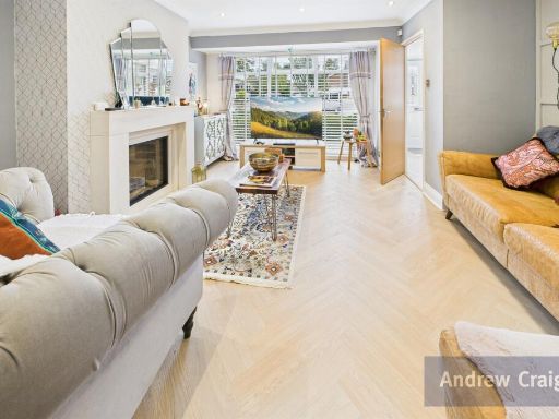
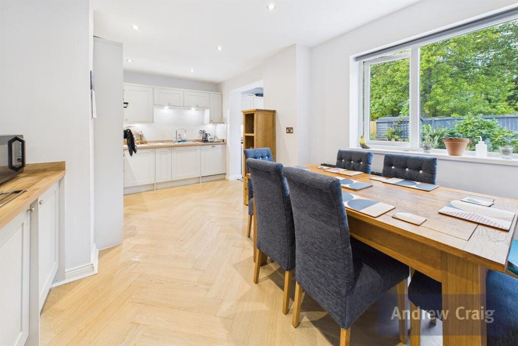
- Lounge/Dining Area:
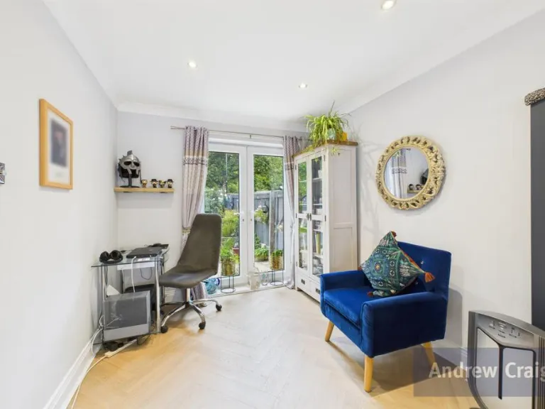
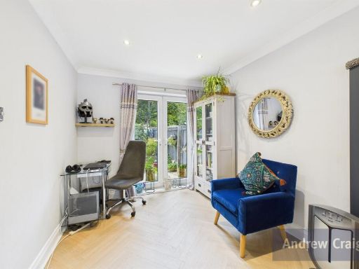
- Hallway:
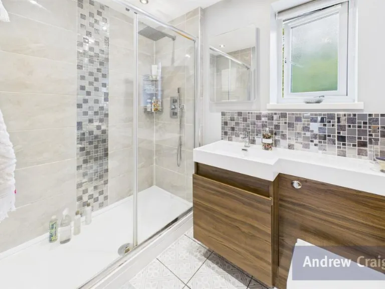
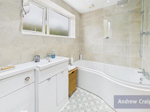
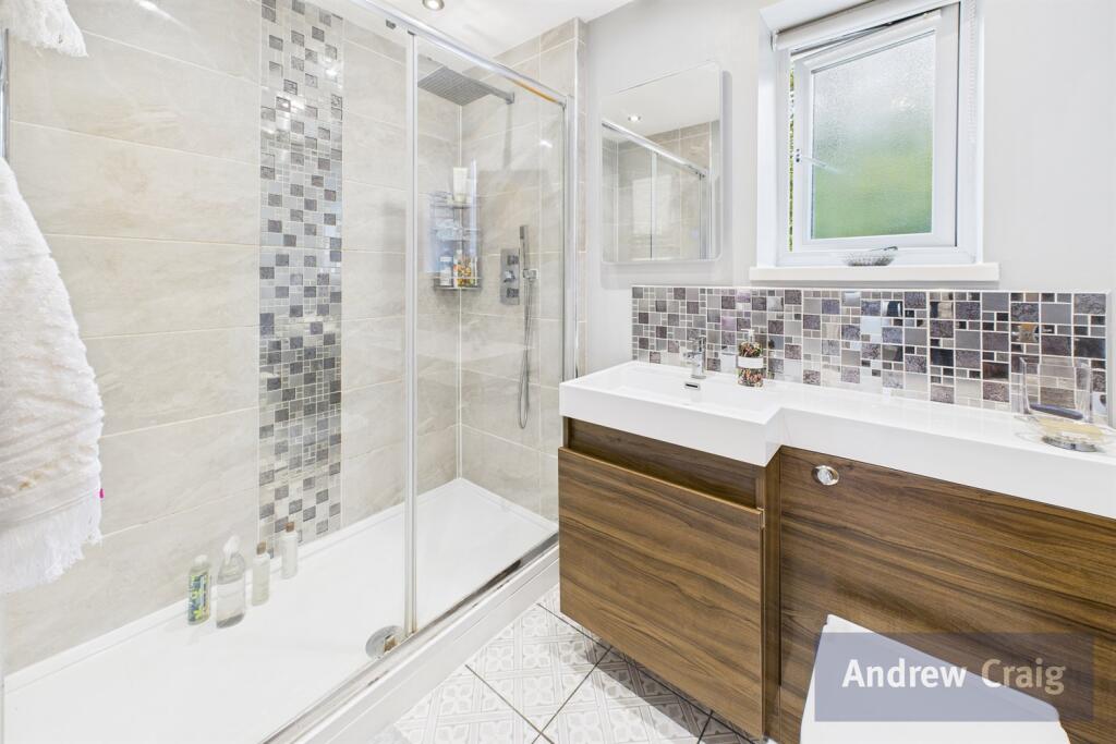
- En-Suite:
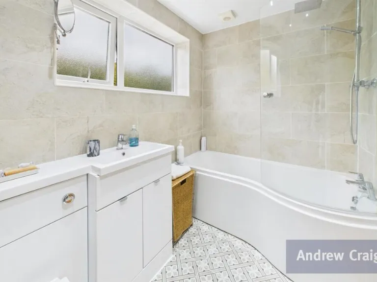
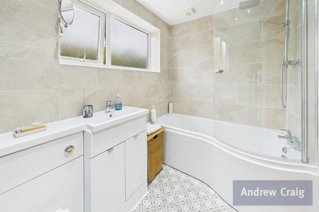
- Bathroom:
- Landing:
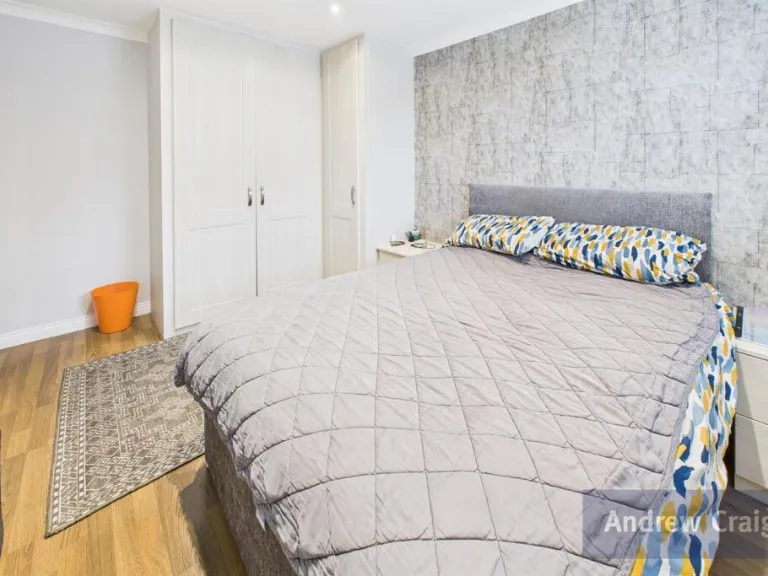
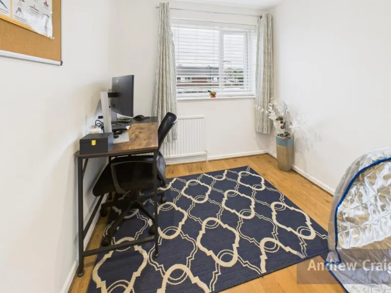
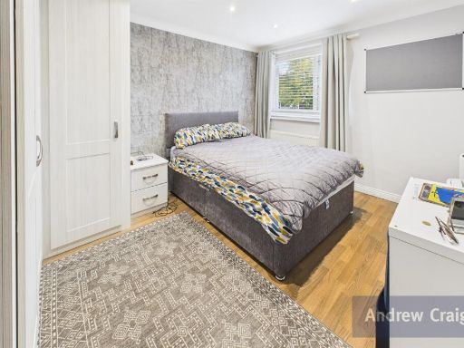
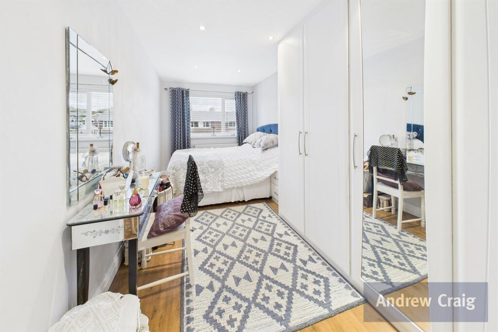
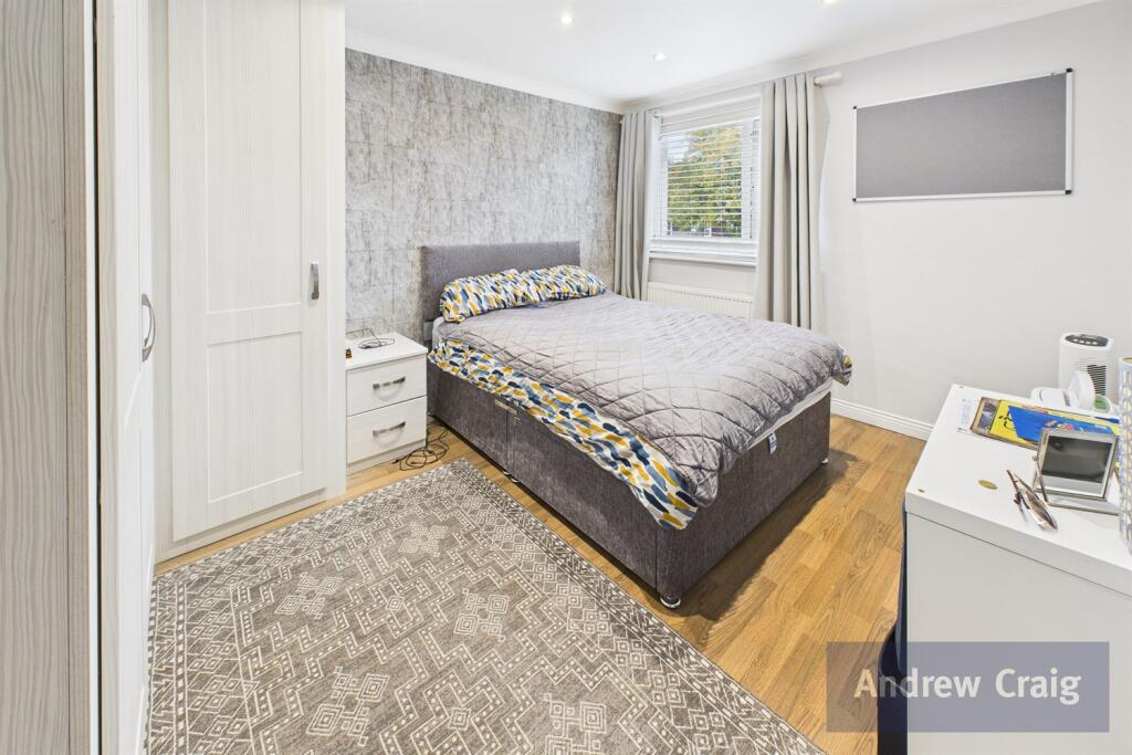
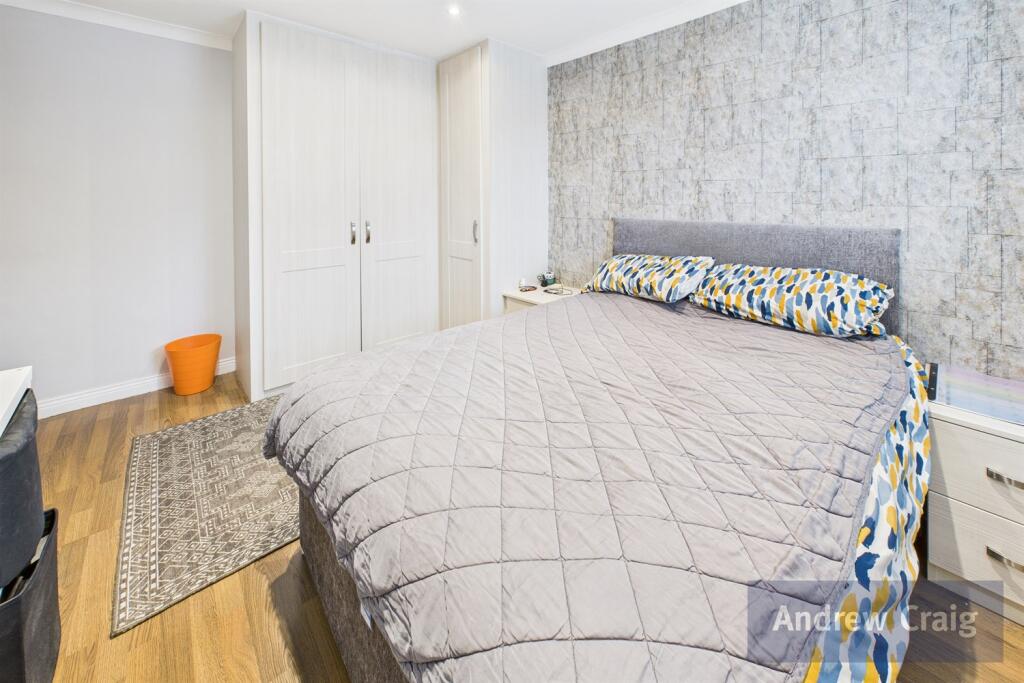
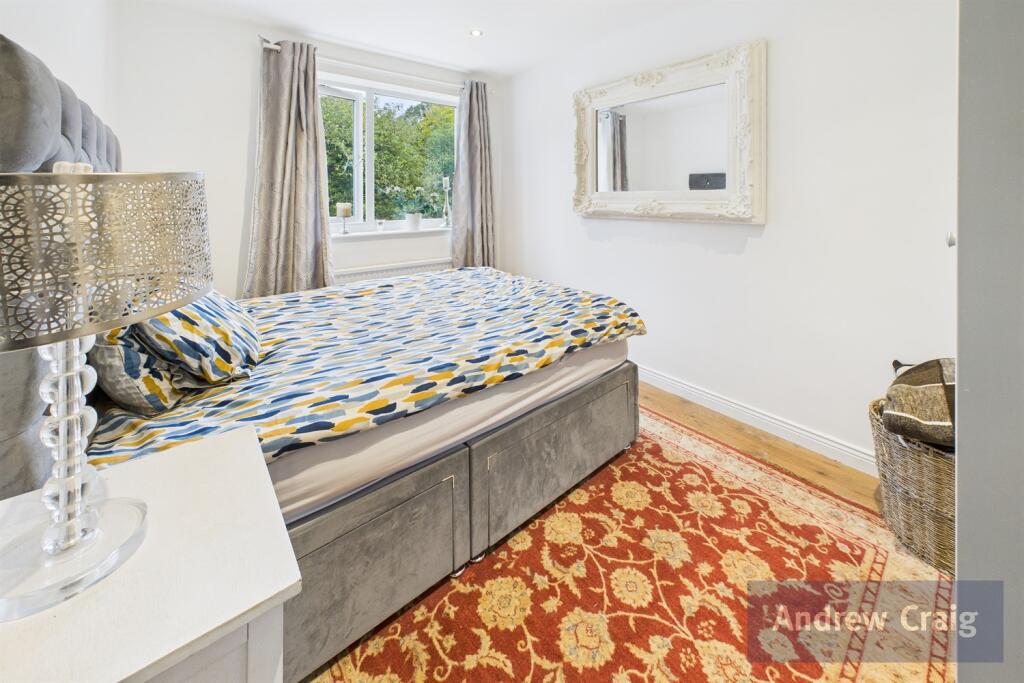
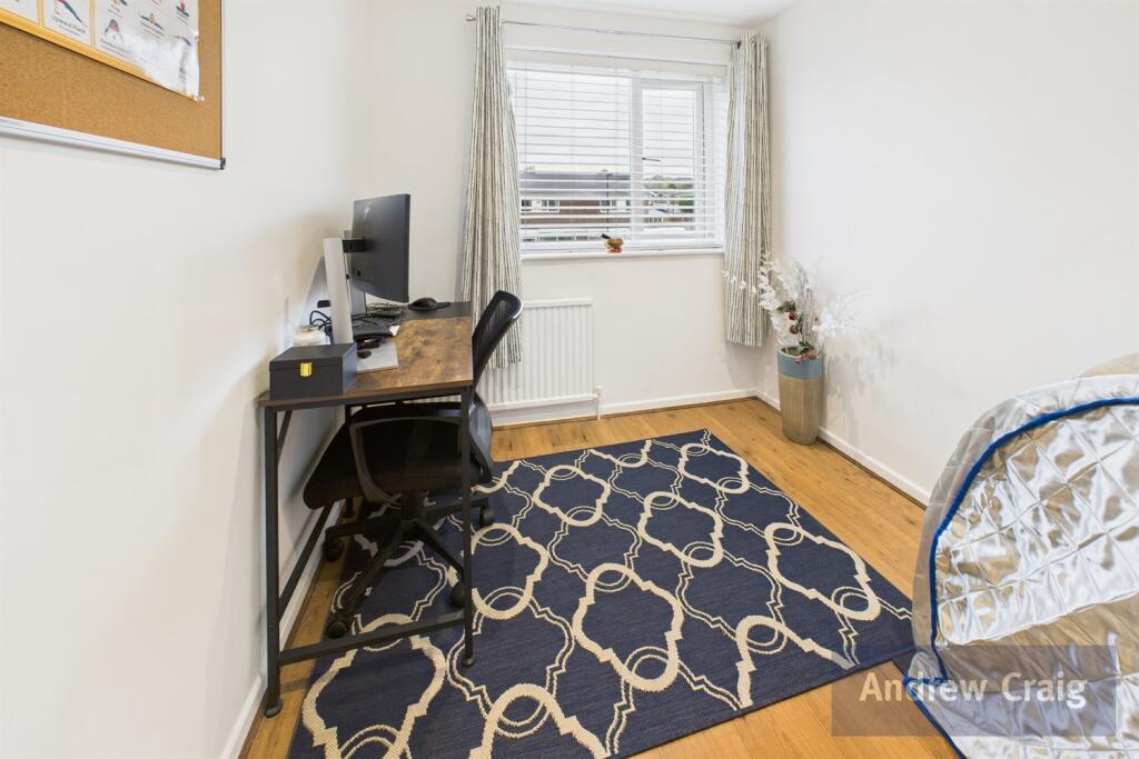
- Bedroom:
- Bedroom:
- Bedroom:
- Bedroom:
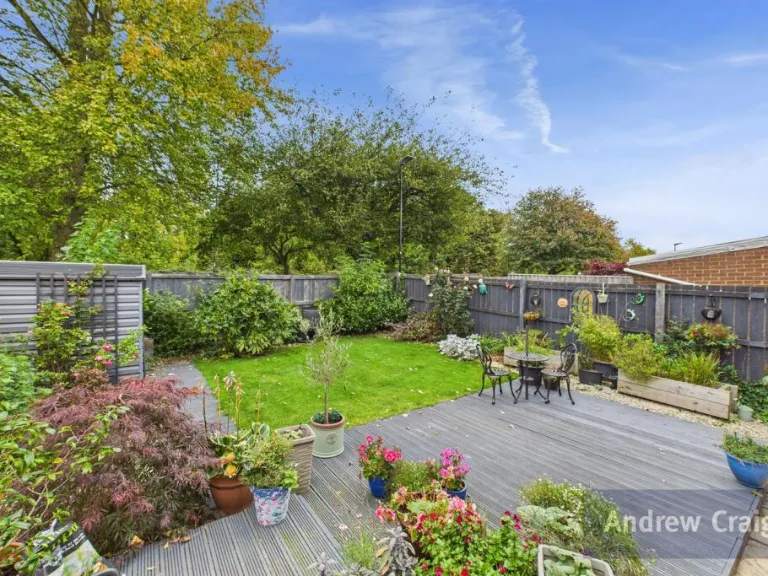
Textual Property Features
Detected Visual Features
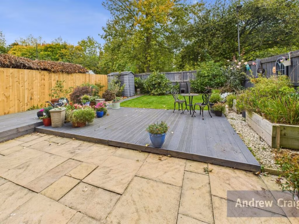
- modern detached home
- double-storey
- driveway
- garage
- front garden
- residential area
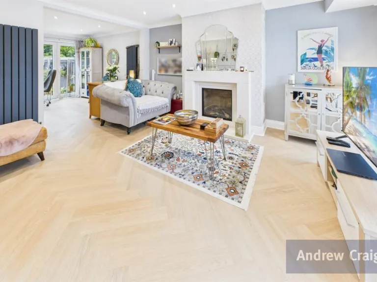
- modern
- living room
- wood flooring
- fireplace
- bright
- spacious
- open plan
EPC Details
- Fully double glazed
- Cavity wall, as built, partial insulation (assumed)
- Boiler and radiators, mains gas
- Low energy lighting in 80% of fixed outlets
- Suspended, no insulation (assumed)
Nearby Schools
- Gillas Lane Primary Academy
- Farringdon Community Academy
- Venerable Bede Church of England Academy
- St Cuthbert's Catholic Primary School, Sunderland
- Barnes Infant Academy
- St Anne's Roman Catholic Voluntary Aided Primary School
- St Leonard's Catholic Primary School, Silksworth
- Hasting Hill Academy
- Thorney Close Primary School
- Sandhill View Academy
- Plains Farm Academy
- Richard Avenue Primary School
- Barnes Junior School
- Academy 360
- Benedict Biscop Church of England Academy
- Grindon Infant School
- Broadway Junior School
- Eppleton Academy Primary School
- Mill Hill Primary School
- East Herrington Primary Academy
- New Silksworth Academy Junior
- New Silksworth Academy Infant
- Farringdon Academy
- Christ's College
- Highfield Academy
Nearest General Shops
- Id: 4032723247
- Tags:
- Addr:
- City: Sunderland
- Street: Allendale Road
- Name: The Local Butcher
- Shop: butcher
- TagsNormalized:
- Lat: 54.8735895
- Lon: -1.4284214
- FullGeoHash: gcybpmrvg67z
- PartitionGeoHash: gcyb
- Images:
- FoodStandards: null
- Distance: 794.2
,- Id: 5550200620
- Tags:
- Addr:
- City: Sunderland
- Housenumber: 3
- Postcode: SR3 3XL
- Street: Victory Way
- Brand: Greggs
- Brand:wikidata: Q3403981
- Brand:wikipedia: en:Greggs
- Contact:
- Website: https://www.greggs.co.uk/shop-finder?shop-code=1504
- Cuisine: sandwich
- Drive_through: no
- Fhrs:
- Name: Greggs
- Outdoor_seating: no
- Shop: bakery
- Smoking: no
- Source:
- Takeaway: only
- TagsNormalized:
- greggs
- sandwich
- bakery
- shop
- takeaway
- Lat: 54.8639345
- Lon: -1.4346954
- FullGeoHash: gcybp7em94tt
- PartitionGeoHash: gcyb
- Images:
- FoodStandards:
- Id: 652428
- FHRSID: 652428
- LocalAuthorityBusinessID: 002131-2
- BusinessName: Greggs
- BusinessType: Retailers - other
- BusinessTypeID: 4613
- AddressLine1: 3
- AddressLine2: Victory Way
- AddressLine3: Sunderland
- AddressLine4: null
- PostCode: SR3 3XL
- RatingValue: 5
- RatingKey: fhrs_5_en-GB
- RatingDate: 2019-02-20
- LocalAuthorityCode: 429
- LocalAuthorityName: Sunderland
- LocalAuthorityWebSite: http://www.sunderland.gov.uk
- LocalAuthorityEmailAddress: public.health@sunderland.gov.uk
- Scores:
- Hygiene: 0
- Structural: 0
- ConfidenceInManagement: 0
- NewRatingPending: false
- Geocode:
- Longitude: -1.43458500000000
- Latitude: 54.86400200000000
- Distance: 413.5
,- Id: 5550201322
- Tags:
- TagsNormalized:
- Lat: 54.864001
- Lon: -1.4346711
- FullGeoHash: gcybp7emcxp9
- PartitionGeoHash: gcyb
- Images:
- FoodStandards: null
- Distance: 407.3
}
Nearest Medical buildings
- Id: 653977161
- Tags:
- Amenity: dentist
- Building: yes
- Healthcare: dentist
- Name: MyDentist
- TagsNormalized:
- Lat: 54.8754471
- Lon: -1.4376966
- FullGeoHash: gcybpmc0ehz8
- PartitionGeoHash: gcyb
- Images:
- FoodStandards: null
- Distance: 1108.5
,- Id: 5588522930
- Tags:
- Addr:
- Amenity: veterinary
- Name: Park Veterinary Clinic
- TagsNormalized:
- Lat: 54.8663728
- Lon: -1.4170968
- FullGeoHash: gcybpu05g30n
- PartitionGeoHash: gcyb
- Images:
- FoodStandards: null
- Distance: 827.7
,- Id: 4032723243
- Tags:
- Addr:
- City: Sunderland
- Street: Allendale Road
- Amenity: pharmacy
- Healthcare: pharmacy
- Name: Demnox Pharmacy
- TagsNormalized:
- Lat: 54.8738528
- Lon: -1.4280898
- FullGeoHash: gcybpt2p75e4
- PartitionGeoHash: gcyb
- Images:
- FoodStandards: null
- Distance: 826.2
,- Id: 5550201325
- Tags:
- Amenity: pharmacy
- Dispensing: yes
- Healthcare: pharmacy
- Name: Demnox Pharmacy
- TagsNormalized:
- Lat: 54.8666228
- Lon: -1.4171609
- FullGeoHash: gcybpu0j1zb1
- PartitionGeoHash: gcyb
- Images:
- FoodStandards: null
- Distance: 823.6
}
Nearest Airports
- Id: 51496177
- Tags:
- Addr:
- City: Newcastle upon Tyne
- Housename: Newcastle International Airport
- Postcode: NE13 8BZ
- Street: Woolsington
- Aerodrome: international
- Aerodrome:type: public
- Aeroway: aerodrome
- Contact:
- Website: http://www.newcastleairport.com
- Ele: 81
- Iata: NCL
- Icao: EGNT
- Ifr: yes
- Name: Newcastle International Airport
- Old_name: Woolsington Aerodrome
- Operator: Newcastle International Airport Ltd
- Operator:type: private
- Phone: +44 871 882 1121
- Ref: NCL
- Size: 4500000
- Source: Bing
- Vfr: yes
- Website: https://www.newcastleairport.com/
- Wheelchair: yes
- Wikidata: Q8975
- Wikipedia: en:Newcastle International Airport
- TagsNormalized:
- airport
- international airport
- Lat: 55.0385826
- Lon: -1.6925163
- FullGeoHash: gcyc17rwcx2m
- PartitionGeoHash: gcyc
- Images:
- FoodStandards: null
- Distance: 25436.8
,- Id: 224091164
- Tags:
- Addr:
- City: Newcastle upon Tyne
- Postcode: NE13 8BZ
- Street: Woolsington
- Building: hotel
- Contact:
- Facebook: https://www.facebook.com/doubletree.newcastle
- Google_plus: https://plus.google.com/115643701064921491168/about
- Twitter: https://twitter.com/dtnewcastle_int
- Email: info@doubletree-newcastle.co.uk
- Fhrs:
- Name: DoubleTree by Hilton Hotel Newcastle International Airport
- Operator: Hilton Worldwide
- Phone: +44 1661 824266
- Rooms: 179
- Smoking: no
- Stars: 4
- Tourism: hotel
- Website: https://doubletree3.hilton.com/en/hotels/united-kingdom/doubletree-by-hilton-hotel-newcastle-international-airport-NCLNADI/index.html?WT.mc_id=zELWAKN0EMEA1DT2DMH3LocalSearch4DGGenericx6NCLNADI
- Wheelchair: yes
- TagsNormalized:
- hotel
- airport
- international airport
- tourism
- major airport
- Lat: 55.0364476
- Lon: -1.7124358
- FullGeoHash: gcyc1514937m
- PartitionGeoHash: gcyc
- Images:
- FoodStandards:
- Id: 236731
- FHRSID: 236731
- LocalAuthorityBusinessID: 11/00246/MIXED
- BusinessName: Doubletree By Hilton Hotel
- BusinessType: Hotel/bed & breakfast/guest house
- BusinessTypeID: 7842
- AddressLine1: Doubletree By Hilton Newcastle Airport
- AddressLine2: Woolsington
- AddressLine3: Newcastle Upon Tyne
- AddressLine4: null
- PostCode: NE13 8BZ
- RatingValue: 5
- RatingKey: fhrs_5_en-GB
- RatingDate: 2019-08-13
- LocalAuthorityCode: 416
- LocalAuthorityName: Newcastle Upon Tyne
- LocalAuthorityWebSite: http://www.newcastle.gov.uk/
- LocalAuthorityEmailAddress: psr@newcastle.gov.uk
- Scores:
- Hygiene: 0
- Structural: 5
- ConfidenceInManagement: 0
- NewRatingPending: false
- Geocode:
- Longitude: -1.71254240000000
- Latitude: 55.03664040000000
- Distance: 26120.4
}
Nearest Leisure Facilities
- Id: 161887377
- Tags:
- Leisure: pitch
- Sport: tennis
- TagsNormalized:
- Lat: 54.8638215
- Lon: -1.4297298
- FullGeoHash: gcybp7wuuvs5
- PartitionGeoHash: gcyb
- Images:
- FoodStandards: null
- Distance: 299.2
,- Id: 684535980
- Tags:
- Leisure: swimming_pool
- Lit: no
- Location: outdoor
- TagsNormalized:
- swimming
- swimming pool
- pool
- leisure
- Lat: 54.8642149
- Lon: -1.4312069
- FullGeoHash: gcybp7tz4qyv
- PartitionGeoHash: gcyb
- Images:
- FoodStandards: null
- Distance: 265.8
,- Id: 62213518
- Tags:
- Building: yes
- Fee: yes
- Leisure: sports_centre
- Name: David Lloyd Fitness Sunderland
- Source: OS Open data
- TagsNormalized:
- sports
- sports centre
- leisure
- fitness
- Lat: 54.8647601
- Lon: -1.4308426
- FullGeoHash: gcybp7y46uw6
- PartitionGeoHash: gcyb
- Images:
- FoodStandards: null
- Distance: 201.1
,- Id: 393492182
- Tags:
- Leisure: club_house
- Name: The Wearside
- Sport: racquet
- TagsNormalized:
- Lat: 54.8649786
- Lon: -1.4316741
- FullGeoHash: gcybp7v7xt63
- PartitionGeoHash: gcyb
- Images:
- FoodStandards: null
- Distance: 199.9
,- Id: 642193819
- Tags:
- TagsNormalized:
- outdoor
- outdoor seating
- leisure
- Lat: 54.8668314
- Lon: -1.4316848
- FullGeoHash: gcybpkjqrqdm
- PartitionGeoHash: gcyb
- Images:
- FoodStandards: null
- Distance: 111.9
}
Nearest Tourist attractions
- Id: 990180844
- Tags:
- Name: Showmen's Guild Site - Sunnyside Farm
- Tourism: caravan_site
- TagsNormalized:
- Lat: 54.8500066
- Lon: -1.4789882
- FullGeoHash: gcybn35h3n66
- PartitionGeoHash: gcyb
- Images:
- FoodStandards: null
- Distance: 3631.2
,- Id: 8777061308
- Tags:
- TagsNormalized:
- Lat: 54.8947223
- Lon: -1.4094826
- FullGeoHash: gcybrcm8utvt
- PartitionGeoHash: gcyb
- Images:
- FoodStandards: null
- Distance: 3401.6
,- Id: 775325991
- Tags:
- Name: Down at the Farm
- Tourism: zoo
- Website: https://www.downatthefarm.co.uk/
- Zoo: petting_zoo
- TagsNormalized:
- Lat: 54.8542252
- Lon: -1.4419774
- FullGeoHash: gcybp1vvp2xx
- PartitionGeoHash: gcyb
- Images:
- FoodStandards: null
- Distance: 1565.2
}
Nearest Train stations
- Id: 4492377636
- Tags:
- Name: Pallion
- Naptan:
- Network: Tyne and Wear Metro
- Operator: Nexus
- Public_transport: station
- Railway: station
- Station: light_rail
- Wikidata: Q7127895
- Wikipedia: en:Pallion Metro station
- TagsNormalized:
- Lat: 54.9127413
- Lon: -1.4178547
- FullGeoHash: gcybrsx9csfv
- PartitionGeoHash: gcyb
- Images:
- FoodStandards: null
- Distance: 5199.6
,- Id: 208521082
- Tags:
- Light_rail: yes
- Name: Park Lane
- Naptan:
- Network: Tyne and Wear Metro
- Operator: Nexus
- Public_transport: station
- Railway: station
- Ref:
- Station: light_rail
- Wikipedia: en:Park Lane Interchange
- TagsNormalized:
- Lat: 54.902301
- Lon: -1.3846154
- FullGeoHash: gcz026xv04ey
- PartitionGeoHash: gcz0
- Images:
- FoodStandards: null
- Distance: 4927.4
,- Id: 4492377632
- Tags:
- Name: Millfield
- Naptan:
- Network: Tyne and Wear Metro
- Operator: Nexus
- Public_transport: station
- Railway: station
- Station: light_rail
- Wikidata: Q6859477
- Wikipedia: en:Millfield Metro station
- TagsNormalized:
- Lat: 54.9064665
- Lon: -1.4010132
- FullGeoHash: gcz0257v650y
- PartitionGeoHash: gcz0
- Images:
- FoodStandards: null
- Distance: 4815.3
,- Id: 4524012054
- Tags:
- Light_rail: yes
- Name: University
- Naptan:
- Network: Tyne and Wear Metro
- Operator: Nexus
- Public_transport: station
- Railway: station
- Station: light_rail
- Wikipedia: en:University Metro station
- TagsNormalized:
- Lat: 54.9027916
- Lon: -1.392096
- FullGeoHash: gcz026drcy1u
- PartitionGeoHash: gcz0
- Images:
- FoodStandards: null
- Distance: 4708
,- Id: 4492377641
- Tags:
- Name: South Hylton
- Naptan:
- Network: Tyne and Wear Metro
- Operator: Nexus
- Public_transport: station
- Railway: station
- Ref:
- Station: light_rail
- Wikidata: Q7567520
- Wikipedia: en:South Hylton Metro station
- TagsNormalized:
- Lat: 54.9042829
- Lon: -1.4476867
- FullGeoHash: gcybr51bdkns
- PartitionGeoHash: gcyb
- Images:
- FoodStandards: null
- Distance: 4349.7
}
Nearest Hotels
- Id: 732472173
- Tags:
- Addr:
- City: Sunderland
- Housenumber: 1-3
- Postcode: SR1 3QD
- Street: Hind Street
- Brand: Premier Inn
- Brand:wikidata: Q2108626
- Brand:wikipedia: en:Premier Inn
- Building: yes
- Fhrs:
- Name: Premier Inn
- Source:
- Tourism: hotel
- TagsNormalized:
- Lat: 54.9059898
- Lon: -1.3913188
- FullGeoHash: gcz0276fefmd
- PartitionGeoHash: gcz0
- Images:
- FoodStandards: null
- Distance: 5040.3
,- Id: 457101680
- Tags:
- Addr:
- City: Sunderland
- Postcode: SR1 3PY
- Street: Low Row
- Brand: Travelodge
- Brand:wikidata: Q9361374
- Brand:wikipedia: en:Travelodge UK
- Building: yes
- Fhrs:
- Authority: Sunderland
- Id: 652574
- Local_authority_id: 002454-1
- Name: Travelodge
- Source:
- Tourism: hotel
- TagsNormalized:
- Lat: 54.9051795
- Lon: -1.3894874
- FullGeoHash: gcz027hjye71
- PartitionGeoHash: gcz0
- Images:
- FoodStandards: null
- Distance: 5021.5
,- Id: 1631336621
- Tags:
- Addr:
- Housename: Shipwrights Hotel
- Street: Ferryboat Lane
- Amenity: pub
- Name: Shipwrights Hotel
- TagsNormalized:
- Lat: 54.9064037
- Lon: -1.4552654
- FullGeoHash: gcybqgkkcz7r
- PartitionGeoHash: gcyb
- Images:
- FoodStandards: null
- Distance: 4720.8
}
Tags
- modern detached home
- double-storey
- driveway
- garage
- front garden
- residential area
- modern
- living room
- wood flooring
- fireplace
- bright
- spacious
- open plan
Local Market Stats
- Average Price/sqft: £175
- Avg Income: £35700
- Social Housing: 19%
- Planning Success Rate: 94%
Similar Properties
 3 bedroom detached house for sale in Bristlecone, Burdon Vale, Sunderland, SR3 — £175,000 • 3 bed • 2 bath
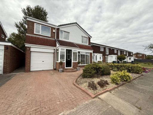 4 bedroom detached house for sale in Manston Close, Sunderland SR3 — £275,000 • 4 bed • 2 bath • 1163 ft²
 4 bedroom detached house for sale in Fairhaven, Sunderland, SR3 — £360,000 • 4 bed • 3 bath • 3331 ft²
 4 bedroom semi-detached house for sale in Orkney Drive, Sunderland, SR2 — £220,000 • 4 bed • 1 bath • 1032 ft²
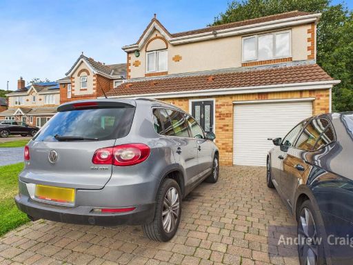 3 bedroom detached house for sale in Bristlecone, Burdon Vale, Sunderland, SR3 — £117,250 • 3 bed • 1 bath
 4 bedroom detached house for sale in The Maltings, Sunderland, SR3 — £355,000 • 4 bed • 2 bath • 1743 ft²
Meta
- {
"@context": "https://schema.org",
"@type": "Residence",
"name": "4 bedroom detached house for sale in Manston Close, Moorsid…",
"description": "",
"url": "https://propertypiper.co.uk/property/f14b40d5-adec-44b6-a923-a2f5ebf6079e",
"image": "https://image-a.propertypiper.co.uk/dc26403f-46ad-42a5-b9e8-d6a11ee8126f-1024.jpeg",
"address": {
"@type": "PostalAddress",
"streetAddress": "26 MANSTON CLOSE SUNDERLAND",
"postalCode": "SR3 2RR",
"addressLocality": "Sunderland",
"addressRegion": "Houghton and Sunderland South",
"addressCountry": "England"
},
"geo": {
"@type": "GeoCoordinates",
"latitude": 54.86650704694742,
"longitude": -1.4300297684152885
},
"numberOfRooms": 4,
"numberOfBathroomsTotal": 2,
"floorSize": {
"@type": "QuantitativeValue",
"value": 1211,
"unitCode": "FTK"
},
"offers": {
"@type": "Offer",
"price": 275000,
"priceCurrency": "GBP",
"availability": "https://schema.org/InStock"
},
"additionalProperty": [
{
"@type": "PropertyValue",
"name": "Feature",
"value": "modern detached home"
},
{
"@type": "PropertyValue",
"name": "Feature",
"value": "double-storey"
},
{
"@type": "PropertyValue",
"name": "Feature",
"value": "driveway"
},
{
"@type": "PropertyValue",
"name": "Feature",
"value": "garage"
},
{
"@type": "PropertyValue",
"name": "Feature",
"value": "front garden"
},
{
"@type": "PropertyValue",
"name": "Feature",
"value": "residential area"
},
{
"@type": "PropertyValue",
"name": "Feature",
"value": "modern"
},
{
"@type": "PropertyValue",
"name": "Feature",
"value": "living room"
},
{
"@type": "PropertyValue",
"name": "Feature",
"value": "wood flooring"
},
{
"@type": "PropertyValue",
"name": "Feature",
"value": "fireplace"
},
{
"@type": "PropertyValue",
"name": "Feature",
"value": "bright"
},
{
"@type": "PropertyValue",
"name": "Feature",
"value": "spacious"
},
{
"@type": "PropertyValue",
"name": "Feature",
"value": "open plan"
}
]
}
High Res Floorplan Images
Compatible Floorplan Images
FloorplanImages Thumbnail