NG24 2NE - Detached house for sale in Barnby Road, Newark, NG24
View on Property Piper
Detached house for sale in Barnby Road, Newark, NG24
Property Details
- Price: £575000
- Bedrooms: 1
- Bathrooms: 1
- Property Type: undefined
- Property SubType: undefined
Brochure Descriptions
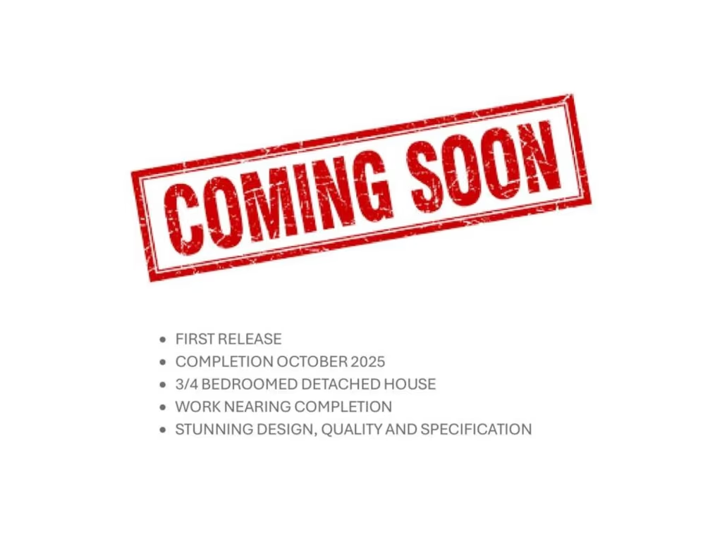
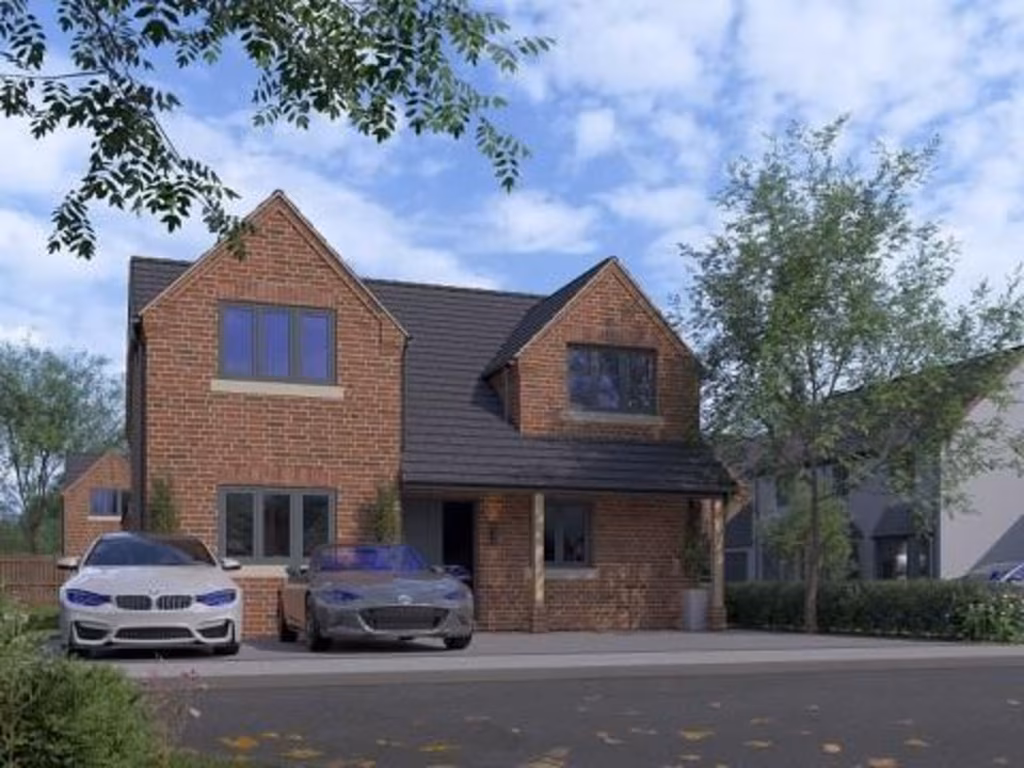
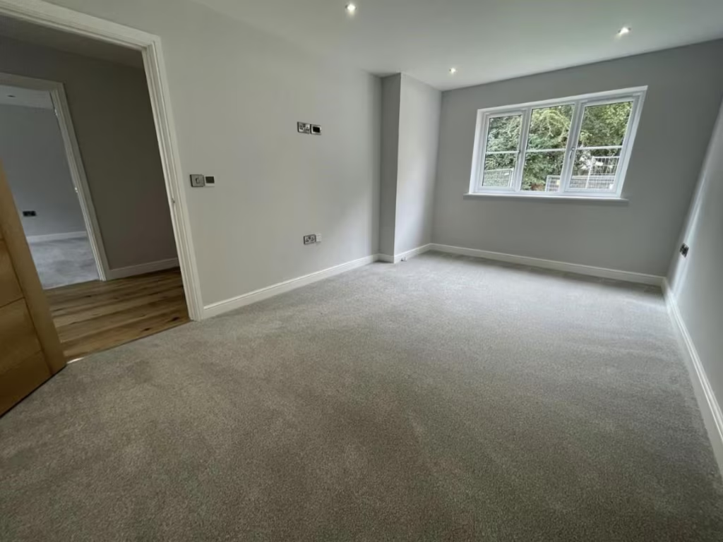
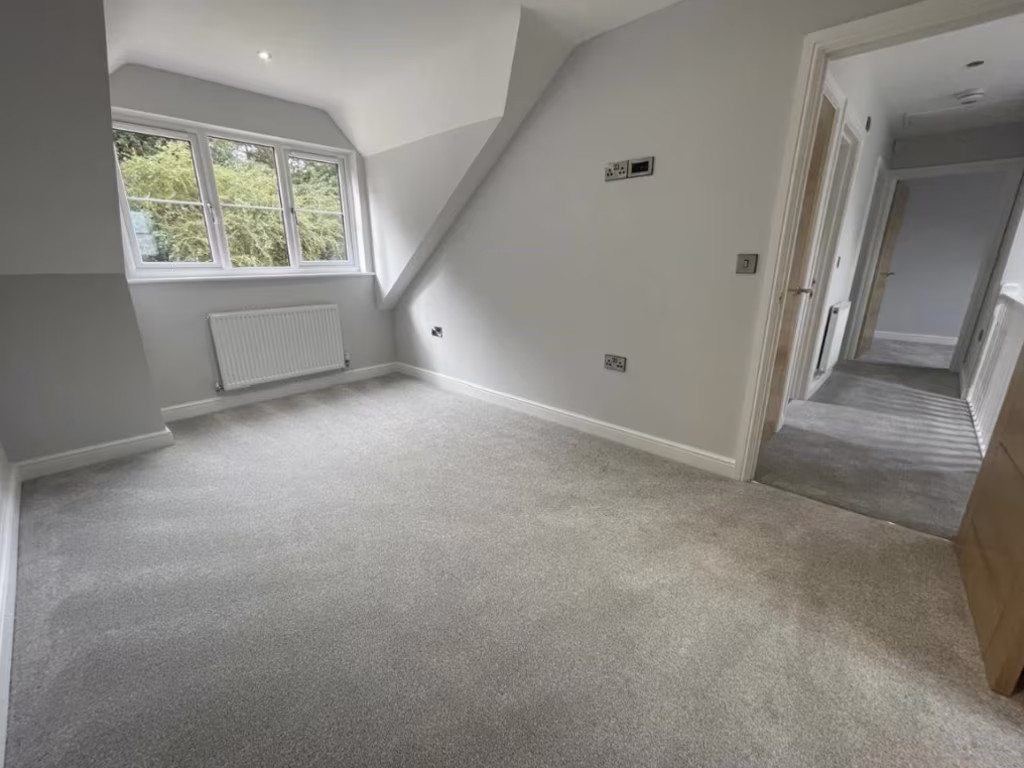
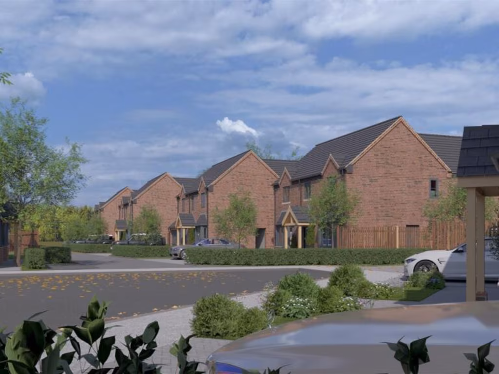
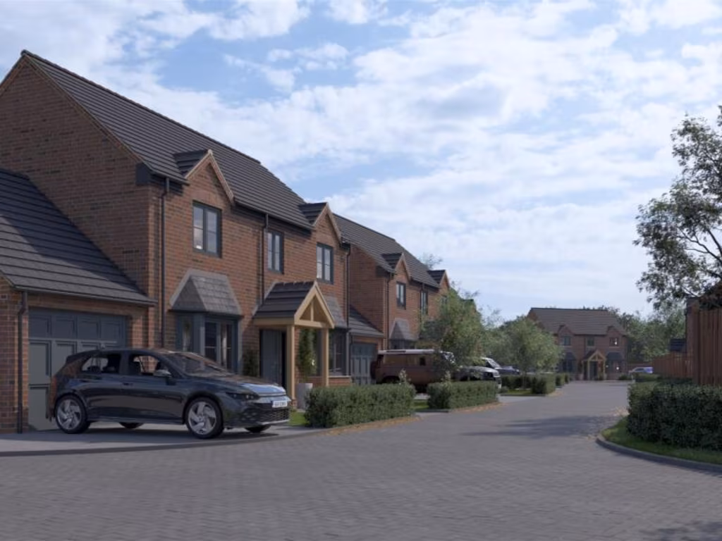
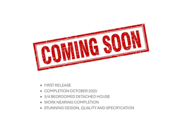
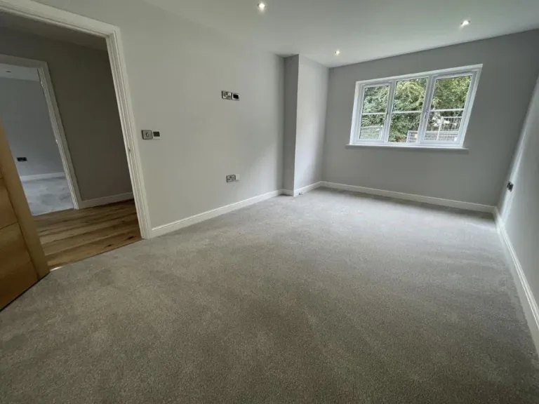
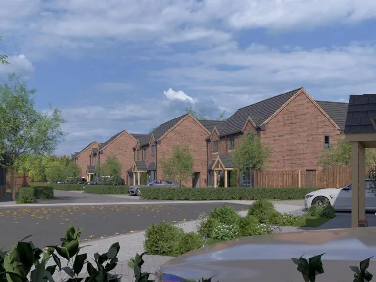
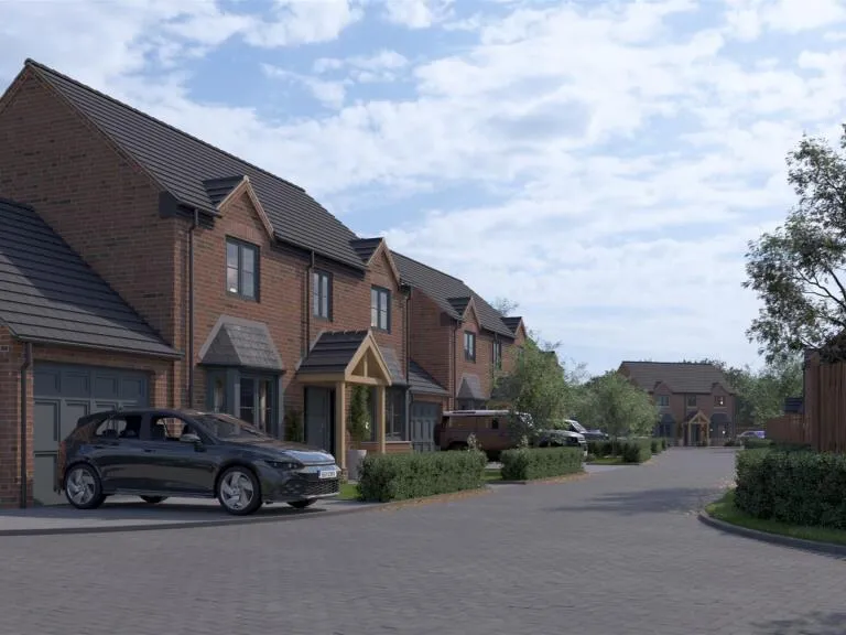
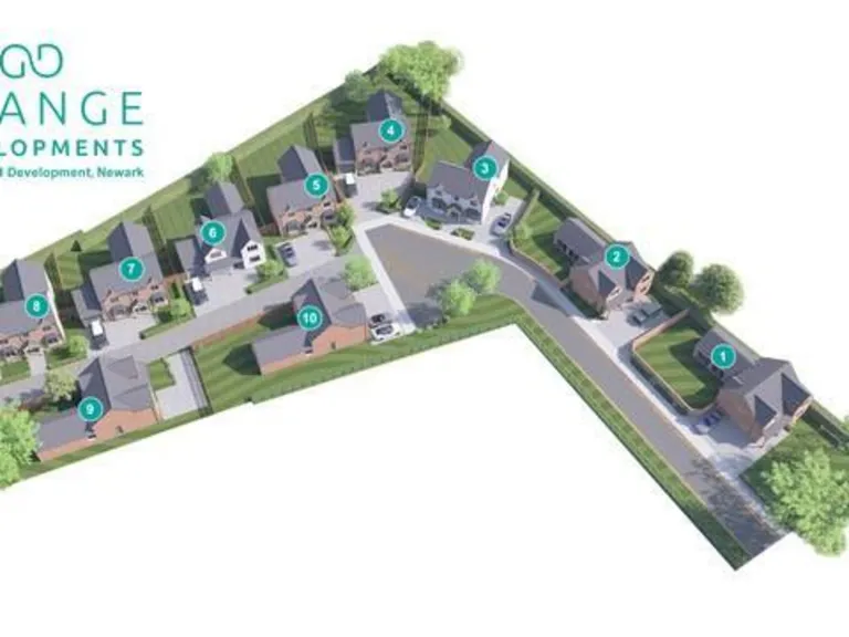
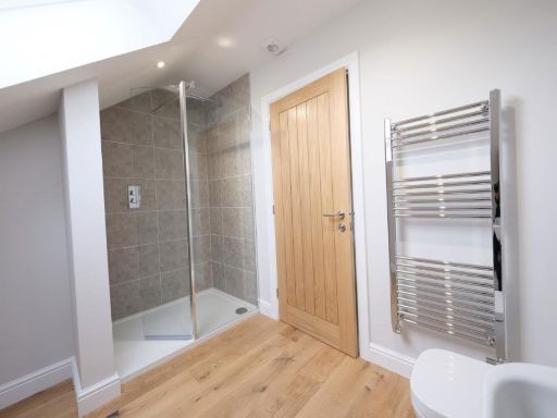
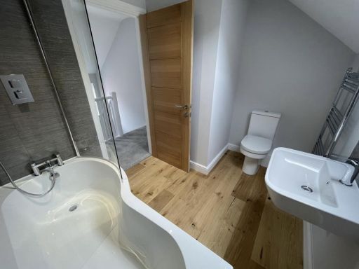
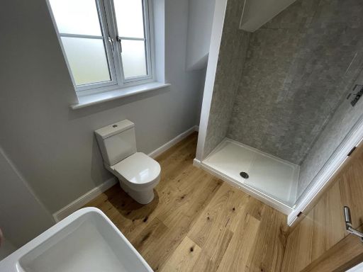
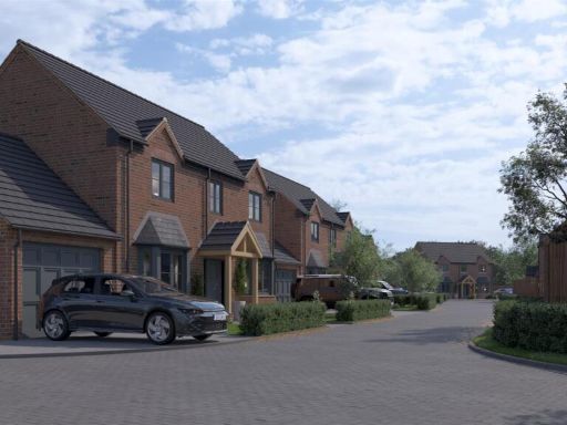
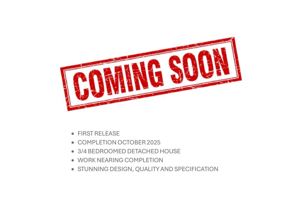
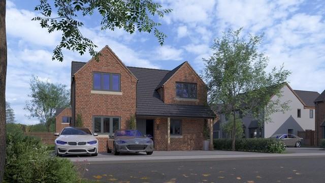
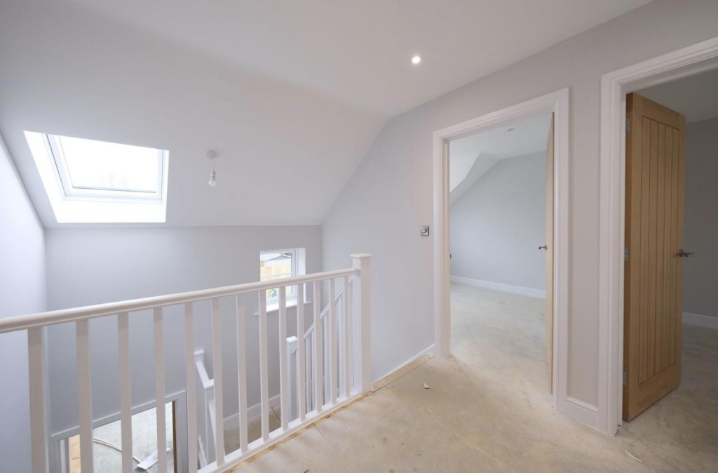
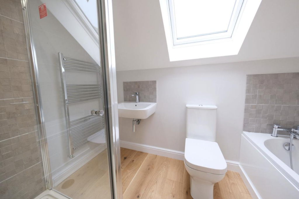
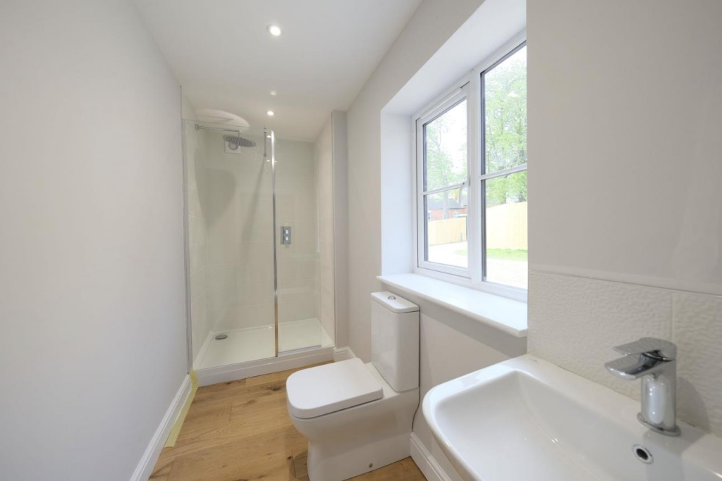
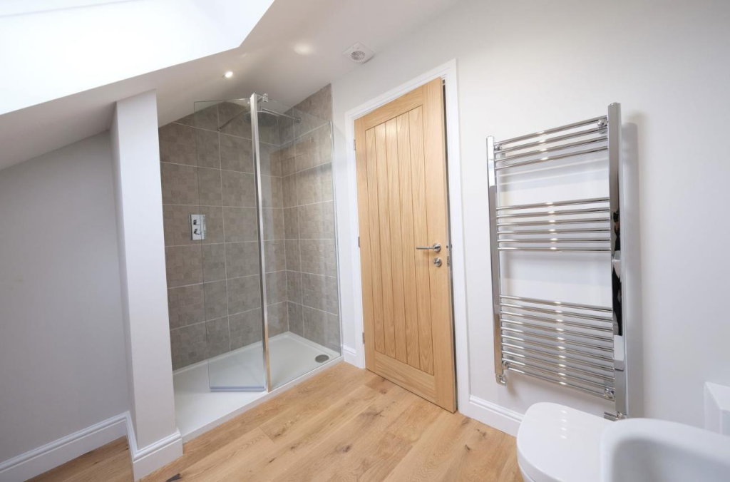
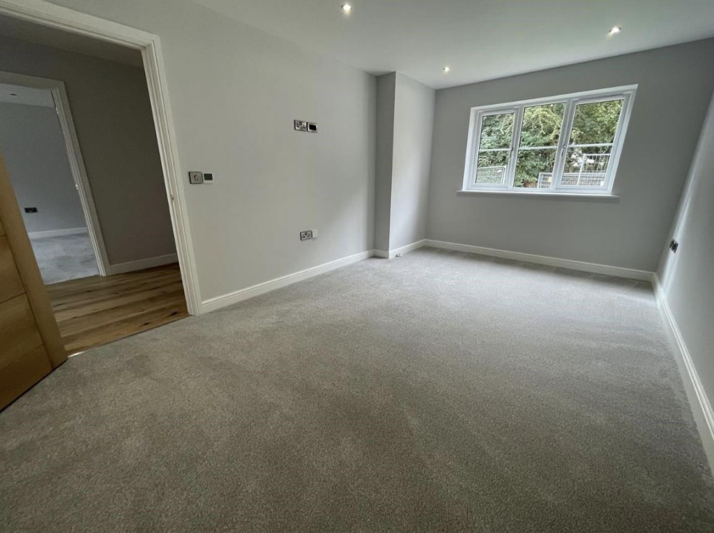
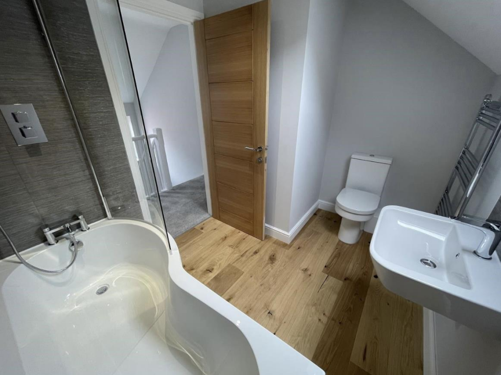
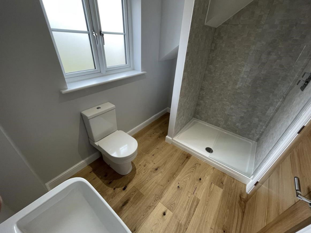
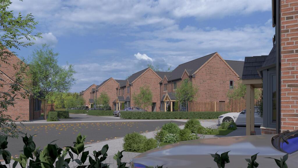
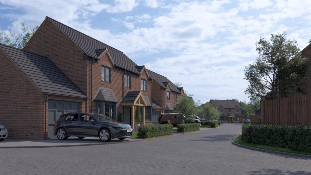
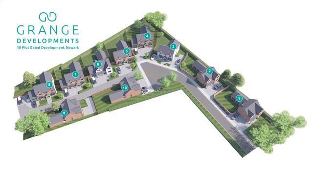
- Off-plan 3/4-bedroom detached house on Plot 10 (No.1) at Grove Grange, Barnby Road, Newark. Listed as a first release with completion forecast October 2025 and works nearing completion. The property is presented as a modern detached family home with a high-quality specification and contemporary design. Likely to provide family-sized accommodation (3 or 4 bedrooms), with typical plot-level outdoor space (small to average garden) and parking provision expected for a detached house. Overall the property appears to be a medium-sized detached dwelling suitable for family occupation, benefiting from new-build specification which will add value on completion. No internal photos or floor areas provided, so room sizes and total floor area cannot be confirmed.
- No explicit residential address is shown on the images. The listing contains a map pinpoint in the Barnby Road / London Road area adjacent to open green space and a linear pond or lake feature (near Barnby Road Academy and Collis Close play area). As viewed on the map, the property for sale appears to be in a suburban setting with immediate access to parkland/greenbelt and local community amenities (Magnus Community Centre nearby). From a valuator’s perspective: location benefits include proximity to open recreational space and schools, which typically support family market demand and positively influence value. The immediate plot size, dwelling type, internal layout and total floor area cannot be determined from the images provided, so a site visit and title/plan review would be required to assess accommodation, plot dimensions and any site-specific constraints or opportunities.
Image Descriptions
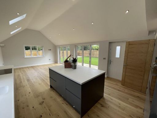
- Modern
- detached house modern
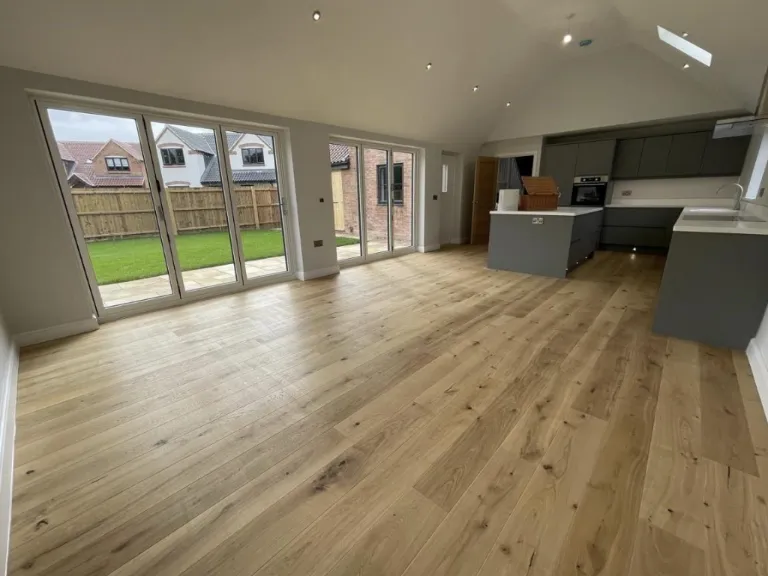
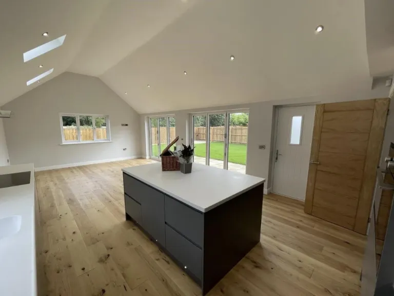
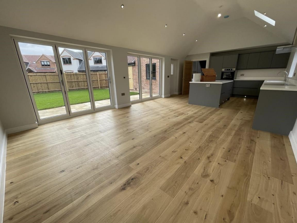
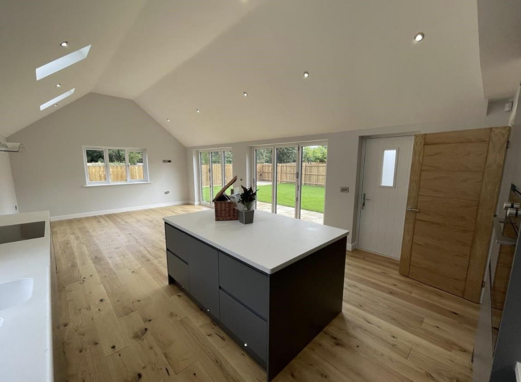
- modern open-plan kitchen and living area contemporary
Floorplan Description
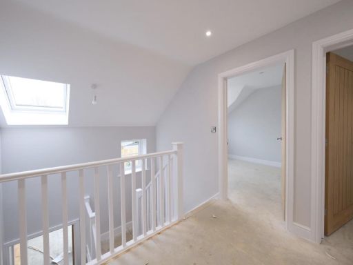
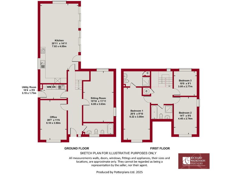
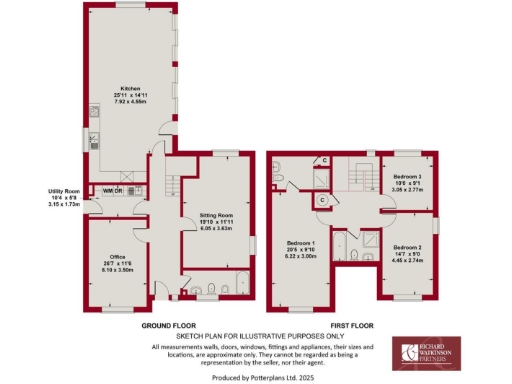
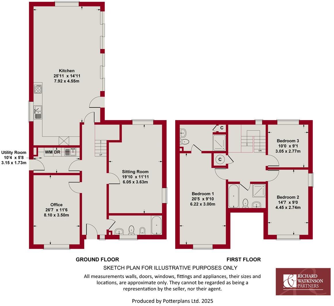
- Two-storey residential property floorplan
Rooms
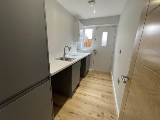
- Kitchen:
- Utility Room:
- Office:
- Sitting Room:
- Bedroom 1:
- Bedroom 2:
- Bedroom 3:
Textual Property Features
- Is New Build
- Has Garden
- Success
Detected Visual Features
- first release
- completion October 2025
- detached house
- 3/4 bedrooms
- new build
- modern design
- quality build
- high specification
- modern house
- detached
- two-story
- family home
- brick exterior
- garage
- driveway
- contemporary
- open-plan
- modern kitchen
- living area
- wood flooring
- bi-fold doors
- natural light
- high ceiling
- large room
- well-finished
EPC Details
- Fully double glazed
- Cavity wall, as built, insulated (assumed)
- Boiler and radiators, mains gas
- Low energy lighting in all fixed outlets
- Solid, limited insulation (assumed)
Nearby Schools
- The Claypole Church of England Primary School
- The Suthers School
- The Newark Academy
- The King's Church of England Primary Academy
- Barnby Road Academy Primary and Nursery school
- Muskham Primary School
- All Saints Anglican/Methodist Primary School
- Chuter Ede Primary School
- The Sir Donald Bailey Academy
- Highfields School
- Christ Church C of E Primary School
- Lovers Lane Primary and Nursery School
- Bishop Alexander L.E.A.D. Academy
- St Peter's Crosskeys CofE Academy
- Magnus Church of England Academy
- Holy Trinity Catholic Voluntary Academy
- John Hunt Academy
- Mount CofE Primary School
- Coddington CofE Primary and Nursery School
- Winthorpe Primary School
Nearest General Shops
- Id: 1089946380
- Tags:
- Addr:
- City: Newark
- Housenumber: 108a
- Street: London Road
- Village: Balderton
- Building: retail
- Building:levels: 1
- Name: Beehive₂
- Roof:
- Shop: hairdresser
- TagsNormalized:
- Lat: 53.0614762
- Lon: -0.7880405
- FullGeoHash: gcrmy5d1t246
- PartitionGeoHash: gcrm
- Images:
- FoodStandards: null
- Distance: 852
,- Id: 10557091046
- Tags:
- TagsNormalized:
- Lat: 53.0726434
- Lon: -0.7974813
- FullGeoHash: gcrmvve693fc
- PartitionGeoHash: gcrm
- Images:
- FoodStandards: null
- Distance: 668.9
,- Id: 10557091044
- Tags:
- TagsNormalized:
- Lat: 53.0723963
- Lon: -0.7969333
- FullGeoHash: gcrmvve9n5er
- PartitionGeoHash: gcrm
- Images:
- FoodStandards: null
- Distance: 623.1
}
Nearest Grocery shops
- Id: 7340203550
- Tags:
- Addr:
- City: Newark
- Postcode: NG24 2JG
- Street: Beacon Hill Road
- Name: Co-op Food
- Shop: convenience
- TagsNormalized:
- co-op
- co-op food
- food
- convenience
- shop
- Lat: 53.0759359
- Lon: -0.7938467
- FullGeoHash: gcrmvyjvwp8f
- PartitionGeoHash: gcrm
- Images:
- FoodStandards: null
- Distance: 816.7
,- Id: 3769021130
- Tags:
- Name: Becon Hill Superstore
- Shop: convenience
- TagsNormalized:
- Lat: 53.0761698
- Lon: -0.791893
- FullGeoHash: gcrmvypr5e1v
- PartitionGeoHash: gcrm
- Images:
- FoodStandards: null
- Distance: 804.2
,- Id: 10557091043
- Tags:
- TagsNormalized:
- Lat: 53.0725585
- Lon: -0.7966257
- FullGeoHash: gcrmvvefj3bz
- PartitionGeoHash: gcrm
- Images:
- FoodStandards: null
- Distance: 617.7
}
Nearest Supermarkets
- Id: 342993328
- Tags:
- Brand: Lincolnshire Co-op
- Brand:wikidata: Q6551231
- Brand:wikipedia: en:Lincolnshire Co-operative
- Building: yes
- Name: Lincolnshire Co-op
- Operator: Lincolnshire Co-operative
- Shop: supermarket
- TagsNormalized:
- Lat: 53.068772
- Lon: -0.8056356
- FullGeoHash: gcrmvsvk524e
- PartitionGeoHash: gcrm
- Images:
- FoodStandards: null
- Distance: 1085.5
,- Id: 481271731
- Tags:
- Addr:
- City: Balderton
- Postcode: NG24 3AQ
- Street: London Road
- Brand: Lidl
- Brand:wikidata: Q151954
- Brand:wikipedia: en:Lidl
- Building: supermarket
- Changing_table: yes
- Fhrs:
- Name: Lidl
- Opening_hours: Mo-Sa 08:00-22:00; Su 10:00-16:00; PH 08:00-20:00
- Operator: Lidl
- Payment:
- Cash: yes
- Contactless: yes
- Credit_cards: yes
- Debit_cards: yes
- Roof:
- Orientation: north
- Shape: skillion
- Shop: supermarket
- Toilets: yes
- Toilets:access: customers
- Toilets:wheelchair: designated
- Wheelchair: yes
- TagsNormalized:
- Lat: 53.0613038
- Lon: -0.7884466
- FullGeoHash: gcrmy59b7zgw
- PartitionGeoHash: gcrm
- Images:
- FoodStandards:
- Id: 957987
- FHRSID: 957987
- LocalAuthorityBusinessID: 17/00039/COMM
- BusinessName: Lidl
- BusinessType: Retailers - supermarkets/hypermarkets
- BusinessTypeID: 7840
- AddressLine1: London Road
- AddressLine2: Balderton
- AddressLine3: Nottinghamshire
- AddressLine4: null
- PostCode: NG24 3AQ
- RatingValue: 5
- RatingKey: fhrs_5_en-GB
- RatingDate: 2020-03-20
- LocalAuthorityCode: 264
- LocalAuthorityName: Newark and Sherwood
- LocalAuthorityWebSite: http://www.newark-sherwooddc.gov.uk/
- LocalAuthorityEmailAddress: environmental.health@nsdc.info
- Scores:
- Hygiene: 0
- Structural: 0
- ConfidenceInManagement: 0
- NewRatingPending: false
- Geocode:
- Longitude: -0.78829400000000
- Latitude: 53.06171800000000
- Distance: 868.6
,- Id: 733068037
- Tags:
- Brand: Lincolnshire Co-op
- Brand:wikidata: Q6551231
- Brand:wikipedia: en:Lincolnshire Co-operative
- Building: yes
- Name: Lincolnshire Co-op
- Operator: Lincolnshire Co-operative Society
- Shop: supermarket
- TagsNormalized:
- Lat: 53.0735069
- Lon: -0.8000114
- FullGeoHash: gcrmvv9rw6u2
- PartitionGeoHash: gcrm
- Images:
- FoodStandards: null
- Distance: 862.3
}
Nearest Religious buildings
- Id: 439046007
- Tags:
- Addr:
- City: Nottingham
- County: Nottinghamshire
- Housename: Magnus Church of England Academy
- Postcode: NG24 4AB
- Street: Earp Avenue
- Suburb: Newark
- Amenity: school
- Denomination: anglican
- Email: office@magnusacademy.co.uk
- Isced:
- Min_age: 11
- Name: Magnus Church of England Academy
- Old_name: Magnus C of E Secondary School
- Operator: Diocese Of Southwell and Nottingham Multi-Academy Trust
- Phone: +44 1636 680 066
- Ref:
- Religion: christian
- Source:
- Addr: edubase
- Geometry: OS_Open_Map_Local_FunctionalSite
- Name: edubase
- Website: https://www.magnusacademy.co.uk/
- Wikidata: Q6732078
- TagsNormalized:
- school
- anglican
- church
- christian
- Lat: 53.0673968
- Lon: -0.8024175
- FullGeoHash: gcrmvsxeyrf0
- PartitionGeoHash: gcrm
- Images:
- FoodStandards: null
- Distance: 890.1
,- Id: 346527517
- Tags:
- Amenity: place_of_worship
- Building: yes
- Name: Beacon Hill Free Christian Fellowship
- Religion: christian
- TagsNormalized:
- place of worship
- christian
- church
- Lat: 53.07614
- Lon: -0.7913095
- FullGeoHash: gcrmvypycjsg
- PartitionGeoHash: gcrm
- Images:
- FoodStandards: null
- Distance: 793.8
,- Id: 10557091045
- Tags:
- Amenity: place_of_worship
- Denomination: methodist
- Name: Charles St Methodist Church
- Religion: christian
- TagsNormalized:
- place of worship
- methodist
- church
- christian
- Lat: 53.0724849
- Lon: -0.7971934
- FullGeoHash: gcrmvve98h38
- PartitionGeoHash: gcrm
- Images:
- FoodStandards: null
- Distance: 643
}
Nearest Medical buildings
- Id: 1087024258
- Tags:
- Addr:
- City: Newark
- Housenumber: 194
- Postcode: NG24 3BN
- Street: London Road
- Amenity: dentist
- Branch: Newark
- Brand: Bupa
- Brand:wikidata: Q931628
- Building: yes
- Building:levels: 2
- Building:material: brick
- Healthcare: dentist
- Name: Bupa Dental Care
- Opening_hours: Mo 09:00-19:00; Tu,Th 08:00-17:00; We 09:00-17:00; Fr 09:00-15:00
- Roof:
- Material: roof_tiles
- Orientation: along
- Shape: gabled
- Website: https://www.bupa.co.uk/dental/dental-care/practices/newark?y_source=1_MTE2NzAwODQtNzE1LWxvY2F0aW9uLndlYnNpdGU%3D
- Wheelchair: yes
- Wifi: free_for_customers
- TagsNormalized:
- dentist
- bupa
- health
- healthcare
- dental
- Lat: 53.0568647
- Lon: -0.7850265
- FullGeoHash: gcrmy4sqes3v
- PartitionGeoHash: gcrm
- Images:
- FoodStandards: null
- Distance: 1390.9
,- Id: 1020277355
- Tags:
- Addr:
- City: Newark
- Housenumber: 50
- Postcode: NG24 1QD
- Street: Barnby Gate
- Amenity: doctors
- Building: yes
- Healthcare: doctor
- Name: Barnby Gate Surgery
- TagsNormalized:
- doctor
- doctors
- health
- healthcare
- surgery
- Lat: 53.0748859
- Lon: -0.8050382
- FullGeoHash: gcrmvtvz97b4
- PartitionGeoHash: gcrm
- Images:
- FoodStandards: null
- Distance: 1227.4
,- Id: 731995408
- Tags:
- Amenity: dentist
- Building: yes
- Healthcare: dentist
- TagsNormalized:
- Lat: 53.0721759
- Lon: -0.8064019
- FullGeoHash: gcrmvtkzc6xh
- PartitionGeoHash: gcrm
- Images:
- FoodStandards: null
- Distance: 1186.6
,- Id: 346317732
- Tags:
- Amenity: hospital
- Healthcare: hospital
- Name: Newark Hospital
- Wikidata: Q30292775
- TagsNormalized:
- Lat: 53.0680199
- Lon: -0.8068495
- FullGeoHash: gcrmvssrx5cm
- PartitionGeoHash: gcrm
- Images:
- FoodStandards: null
- Distance: 1172.1
}
Nearest Airports
- Id: 11359528
- Tags:
- Aerodrome: international
- Aerodrome:type: public
- Aeroway: aerodrome
- Iata: EMA
- Icao: EGNX
- Is_in: Castle Donington,England,UK
- Name: East Midlands Airport
- Old_name: RAF Castle Donington
- Operator: Manchester Airports Holdings Limited
- Operator:type: private
- Ref: EMA
- Type: multipolygon
- Website: https://www.eastmidlandsairport.com/
- Wikidata: Q8977
- Wikipedia: en:East Midlands Airport
- TagsNormalized:
- airport
- international airport
- Lat: 52.8281122
- Lon: -1.3322143
- FullGeoHash: gcrh99jfj1vh
- PartitionGeoHash: gcrh
- Images:
- FoodStandards: null
- Distance: 45173.3
}
Nearest Leisure Facilities
- Id: 944745361
- Tags:
- TagsNormalized:
- Lat: 53.0716438
- Lon: -0.794753
- FullGeoHash: gcrmvvmk8zmn
- PartitionGeoHash: gcrm
- Images:
- FoodStandards: null
- Distance: 456.5
,- Id: 1093599682
- Tags:
- Access: private
- Leisure: swimming_pool
- Location: outdoor
- Swimming_pool: outdoor
- TagsNormalized:
- swimming
- swimming pool
- pool
- leisure
- Lat: 53.0649993
- Lon: -0.7890263
- FullGeoHash: gcrmyh1qn2g6
- PartitionGeoHash: gcrm
- Images:
- FoodStandards: null
- Distance: 456
,- Id: 944745362
- Tags:
- TagsNormalized:
- Lat: 53.0714898
- Lon: -0.7946671
- FullGeoHash: gcrmvvm7ffv2
- PartitionGeoHash: gcrm
- Images:
- FoodStandards: null
- Distance: 441.5
,- Id: 1095669270
- Tags:
- TagsNormalized:
- Lat: 53.0699227
- Lon: -0.795182
- FullGeoHash: gcrmvvhfwyt7
- PartitionGeoHash: gcrm
- Images:
- FoodStandards: null
- Distance: 397.3
,- Id: 1093555259
- Tags:
- Access: private
- Leisure: pitch
- Sport: soccer
- Surface: grass
- TagsNormalized:
- Lat: 53.0660252
- Lon: -0.7915134
- FullGeoHash: gcrmvursh2hf
- PartitionGeoHash: gcrm
- Images:
- FoodStandards: null
- Distance: 369.4
}
Nearest Tourist attractions
- Id: 814709194
- Tags:
- Name: National Civil War Centre
- Tourism: museum
- TagsNormalized:
- Lat: 53.0765219
- Lon: -0.8062279
- FullGeoHash: gcrmvwkcjsbc
- PartitionGeoHash: gcrm
- Images:
- FoodStandards: null
- Distance: 1395.1
,- Id: 1093551979
- Tags:
- Addr:
- Housenumber: 150
- Street: London Road
- Building: residential
- Building:levels: 2
- Building:material: brick
- Guest_house: bed_and_breakfast
- Internet_access: wlan
- Name: Acers Serviced Accommodation
- Roof:
- Tourism: guest_house
- Wheelchair: yes
- TagsNormalized:
- residential
- service
- guest house
- tourism
- Lat: 53.059402
- Lon: -0.7867639
- FullGeoHash: gcrmy55j7j6m
- PartitionGeoHash: gcrm
- Images:
- FoodStandards: null
- Distance: 1092
,- Id: 1092220551
- Tags:
- Addr:
- City: Newark
- Housenumber: 4
- Street: London Road
- Village: Balderton
- Building: semidetached_house
- Building:levels: 2
- Building:material: brick
- Guest_house: bed_and_breakfast
- Internet_access: wlan
- Internet_access:fee: no
- Name: Bridge House Bed and Breakfast
- Phone: +44 1636674663
- Roof:
- Colour: #818F8E
- Material: roof_tiles
- Shape: gabled
- Tourism: guest_house
- Website: http://www.arnoldsbandb.co.uk/
- TagsNormalized:
- detached
- bed
- guest house
- tourism
- Lat: 53.0656205
- Lon: -0.792847
- FullGeoHash: gcrmvuq9tkdk
- PartitionGeoHash: gcrm
- Images:
- FoodStandards: null
- Distance: 449.8
}
Nearest Train stations
- Id: 3152675223
- Tags:
- Name: Collingham
- Naptan:
- Network: National Rail
- Operator: East Midlands Railway
- Public_transport: station
- Railway: station
- Ref:
- Source: NPE
- Wikidata: Q2369236
- Wikipedia: en:Collingham railway station
- TagsNormalized:
- Lat: 53.1439832
- Lon: -0.750266
- FullGeoHash: gcrqqftdjs90
- PartitionGeoHash: gcrq
- Images:
- FoodStandards: null
- Distance: 8727.3
,- Id: 6415345168
- Tags:
- Name: Fiskerton
- Naptan:
- Network: National Rail
- Public_transport: station
- Railway: station
- Ref:
- Source: NPE
- Wikidata: Q606903
- Wikipedia: en:Fiskerton railway station
- TagsNormalized:
- Lat: 53.0606002
- Lon: -0.9118374
- FullGeoHash: gcrmg72h2suc
- PartitionGeoHash: gcrm
- Images:
- FoodStandards: null
- Distance: 8235.6
,- Id: 6415345159
- Tags:
- Name: Rolleston
- Naptan:
- Network: National Rail
- Old_name: Rolleston Junction
- Public_transport: station
- Railway: station
- Ref:
- Source: NPE
- Wikidata: Q2704279
- Wikipedia: en:Rolleston railway station
- TagsNormalized:
- Lat: 53.0651443
- Lon: -0.9001231
- FullGeoHash: gcrmgs0wcege
- PartitionGeoHash: gcrm
- Images:
- FoodStandards: null
- Distance: 7411.1
,- Id: 6415345164
- Tags:
- Name: Newark Castle
- Naptan:
- Network: National Rail
- Public_transport: station
- Railway: station
- Ref:
- Source: NPE
- Wikidata: Q4800289
- Wikipedia: en:Newark Castle railway station
- TagsNormalized:
- Lat: 53.0802549
- Lon: -0.8131753
- FullGeoHash: gcrmvqzygsst
- PartitionGeoHash: gcrm
- Images:
- FoodStandards: null
- Distance: 2015.7
,- Id: 3752912434
- Tags:
- Name: Newark North Gate
- Naptan:
- Network: National Rail
- Public_transport: station
- Railway: station
- Ref:
- Source: NPE
- Wikidata: Q3246476
- Wikipedia: en:Newark North Gate railway station
- TagsNormalized:
- Lat: 53.0813745
- Lon: -0.7994939
- FullGeoHash: gcrmvz1v6mqh
- PartitionGeoHash: gcrm
- Images:
- FoodStandards: null
- Distance: 1523
}
Nearest Hotels
- Id: 363957642
- Tags:
- Addr:
- City: Newark On Trent
- Postcode: NG24 1XG
- Street: Beaumond Cross
- Brand: Travelodge
- Brand:wikidata: Q9361374
- Building: hotel
- Fhrs:
- Authority: Newark and Sherwood
- Id: 1344362
- Local_authority_id: 21/00029/COMM
- Internet_access: wlan
- Internet_access:fee: customers
- Internet_access:ssid: Travelodge WiFi
- Name: Travelodge
- Tourism: hotel
- TagsNormalized:
- Lat: 53.0746251
- Lon: -0.8102247
- FullGeoHash: gcrmvtfn07hw
- PartitionGeoHash: gcrm
- Images:
- FoodStandards: null
- Distance: 1521.2
,- Id: 366304877
- Tags:
- Addr:
- Postcode: NG24 1TF
- Street: London Road
- Brand: Best Western
- Brand:wikidata: Q830334
- Brand:wikipedia: en:Best Western
- Building: yes
- Fhrs:
- Name: Deincourt Hotel
- Source: Mapillary
- Source:addr: FHRS Open Data
- Tourism: hotel
- Website: https://www.deincourthotel.com/
- TagsNormalized:
- Lat: 53.0717676
- Lon: -0.8061008
- FullGeoHash: gcrmvtmj2qx9
- PartitionGeoHash: gcrm
- Images:
- FoodStandards: null
- Distance: 1154.8
,- Id: 446319569
- Tags:
- Addr:
- Housenumber: 71-73
- Postcode: NG24 1RZ
- Street: London Road
- Building: yes
- Fhrs:
- Name: Grange Hotel
- Source: Mapillary
- Source:addr: FHRS Open Data
- Tourism: hotel
- Website: http://www.grangenewark.co.uk/
- TagsNormalized:
- Lat: 53.0699643
- Lon: -0.7992822
- FullGeoHash: gcrmvv1fzq7u
- PartitionGeoHash: gcrm
- Images:
- FoodStandards: null
- Distance: 667.4
}
Tags
- first release
- completion October 2025
- detached house
- 3/4 bedrooms
- new build
- modern design
- quality build
- high specification
- modern house
- detached
- two-story
- family home
- brick exterior
- garage
- driveway
- new build
- contemporary
- open-plan
- modern kitchen
- living area
- wood flooring
- bi-fold doors
- natural light
- high ceiling
- large room
- well-finished
- new build
Local Market Stats
- Average Price/sqft: £216
- Avg Income: £39700
- Rental Yield: 3.7%
- Social Housing: 8%
- Planning Success Rate: 83%
AirBnB Data
- 1km average: £65/night
- Listings in 1km: 1
Similar Properties
 4 bedroom detached house for sale in Barnby Road, Newark, NG24 — £595,000 • 4 bed • 3 bath • 1819 ft²
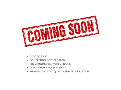 Detached house for sale in Barnby Road, Newark, NG24 — £545,000 • 1 bed • 1 bath • 1733 ft²
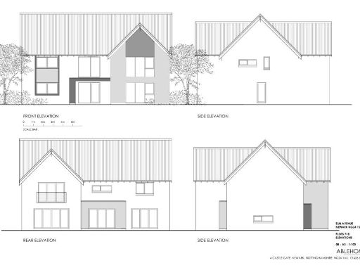 4 bedroom detached house for sale in Pitchfield Place, Newark, NG24 — £875,000 • 4 bed • 3 bath • 2920 ft²
 3 bedroom semi-detached house for sale in Apple Orchard, Hutchinson Road, Newark, NG24 — £349,950 • 3 bed • 2 bath • 1332 ft²
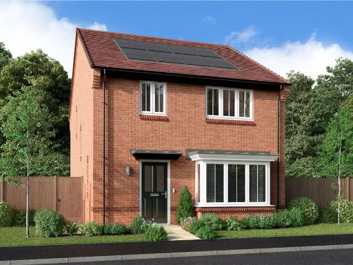 4 bedroom detached house for sale in Bluebell Drive,
Newark on Trent,
NG24 4FS, NG24 — £325,000 • 4 bed • 1 bath • 758 ft²
4 bedroom detached house for sale in Bluebell Drive,
Newark on Trent,
NG24 4FS, NG24 — £325,000 • 4 bed • 1 bath • 758 ft² 5 bedroom detached house for sale in Pitchfield Place, NG24 — £950,000 • 5 bed • 3 bath • 3150 ft²
Meta
- {
"@context": "https://schema.org",
"@type": "Residence",
"name": "Detached house for sale in Barnby Road, Newark, NG24",
"description": "",
"url": "https://propertypiper.co.uk/property/efbf6b3a-ac9b-4a8b-8055-3d865535a85c",
"image": "https://image-a.propertypiper.co.uk/047c5425-c58e-447e-be85-ec50603dd536-1024.jpeg",
"address": {
"@type": "PostalAddress",
"streetAddress": "GROVE MEADOW BARNBY ROAD NEWARK ",
"postalCode": "NG24 2NE",
"addressLocality": "Newark and Sherwood",
"addressRegion": "Newark",
"addressCountry": "England"
},
"geo": {
"@type": "GeoCoordinates",
"latitude": 53.0690945,
"longitude": -0.7893976
},
"numberOfRooms": 1,
"numberOfBathroomsTotal": 1,
"floorSize": {
"@type": "QuantitativeValue",
"value": 1990,
"unitCode": "FTK"
},
"offers": {
"@type": "Offer",
"price": 575000,
"priceCurrency": "GBP",
"availability": "https://schema.org/InStock"
},
"additionalProperty": [
{
"@type": "PropertyValue",
"name": "Feature",
"value": "first release"
},
{
"@type": "PropertyValue",
"name": "Feature",
"value": "completion October 2025"
},
{
"@type": "PropertyValue",
"name": "Feature",
"value": "detached house"
},
{
"@type": "PropertyValue",
"name": "Feature",
"value": "3/4 bedrooms"
},
{
"@type": "PropertyValue",
"name": "Feature",
"value": "new build"
},
{
"@type": "PropertyValue",
"name": "Feature",
"value": "modern design"
},
{
"@type": "PropertyValue",
"name": "Feature",
"value": "quality build"
},
{
"@type": "PropertyValue",
"name": "Feature",
"value": "high specification"
},
{
"@type": "PropertyValue",
"name": "Feature",
"value": "modern house"
},
{
"@type": "PropertyValue",
"name": "Feature",
"value": "detached"
},
{
"@type": "PropertyValue",
"name": "Feature",
"value": "two-story"
},
{
"@type": "PropertyValue",
"name": "Feature",
"value": "family home"
},
{
"@type": "PropertyValue",
"name": "Feature",
"value": "brick exterior"
},
{
"@type": "PropertyValue",
"name": "Feature",
"value": "garage"
},
{
"@type": "PropertyValue",
"name": "Feature",
"value": "driveway"
},
{
"@type": "PropertyValue",
"name": "Feature",
"value": "new build"
},
{
"@type": "PropertyValue",
"name": "Feature",
"value": "contemporary"
},
{
"@type": "PropertyValue",
"name": "Feature",
"value": "open-plan"
},
{
"@type": "PropertyValue",
"name": "Feature",
"value": "modern kitchen"
},
{
"@type": "PropertyValue",
"name": "Feature",
"value": "living area"
},
{
"@type": "PropertyValue",
"name": "Feature",
"value": "wood flooring"
},
{
"@type": "PropertyValue",
"name": "Feature",
"value": "bi-fold doors"
},
{
"@type": "PropertyValue",
"name": "Feature",
"value": "natural light"
},
{
"@type": "PropertyValue",
"name": "Feature",
"value": "high ceiling"
},
{
"@type": "PropertyValue",
"name": "Feature",
"value": "large room"
},
{
"@type": "PropertyValue",
"name": "Feature",
"value": "well-finished"
},
{
"@type": "PropertyValue",
"name": "Feature",
"value": "new build"
}
]
}
High Res Floorplan Images
Compatible Floorplan Images
FloorplanImages Thumbnail