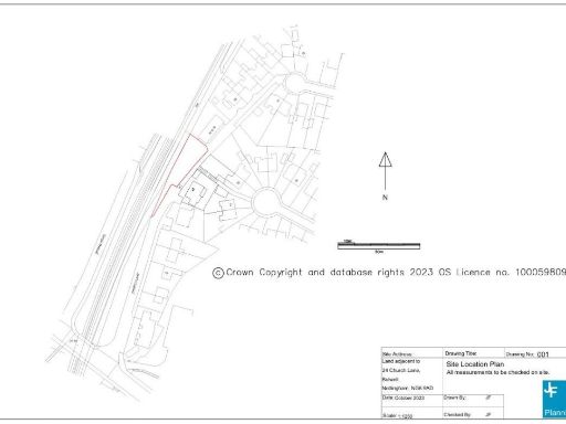
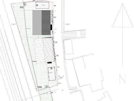
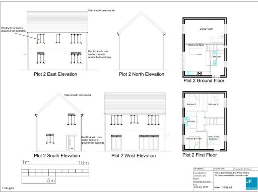
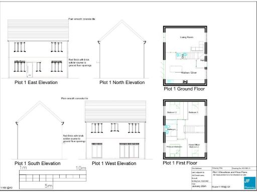
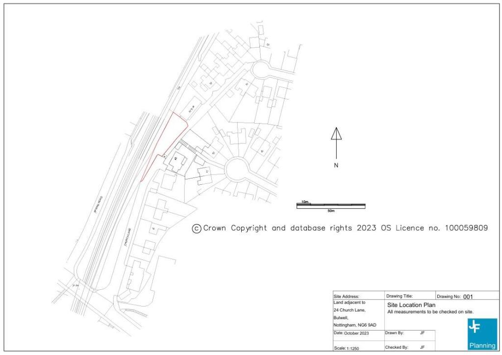
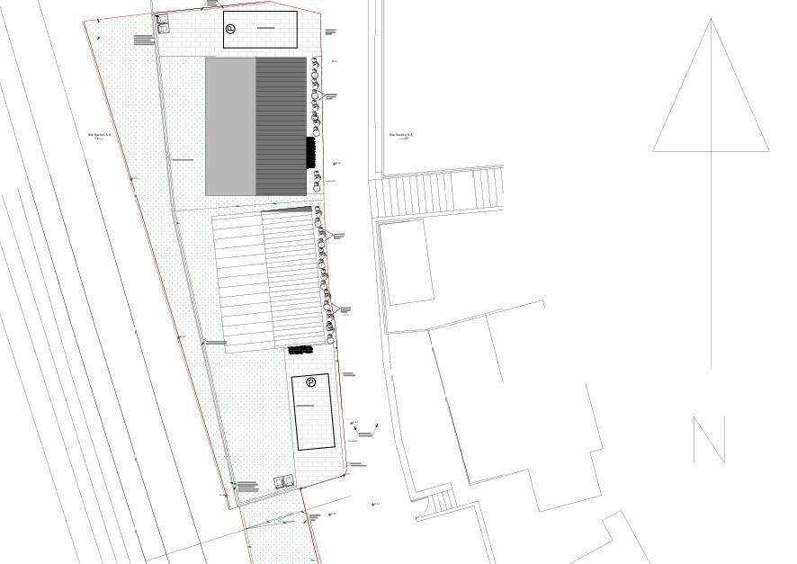
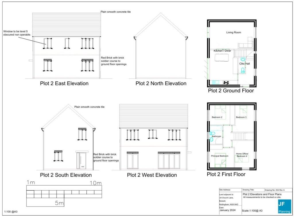
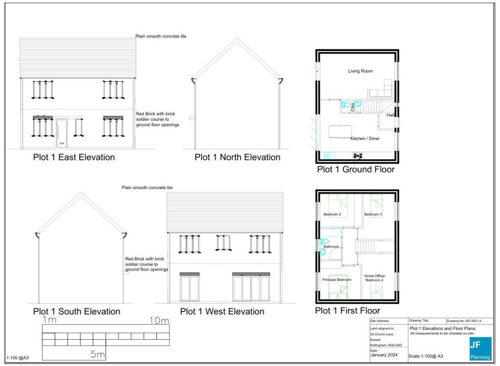
NG6 9AD - Land for sale in Land Between 3236, Church Lane, Bulwell, N…
View on Property Piper
Land for sale in Land Between 32-36, Church Lane, Bulwell, Nottingham, Nottinghamshire NG6 9AD, NG6
Property Details
- Price: £89500
- Bedrooms: 1
- Bathrooms: 1
- Property Type: undefined
- Property SubType: undefined
Textual Property Features
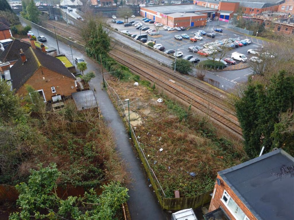
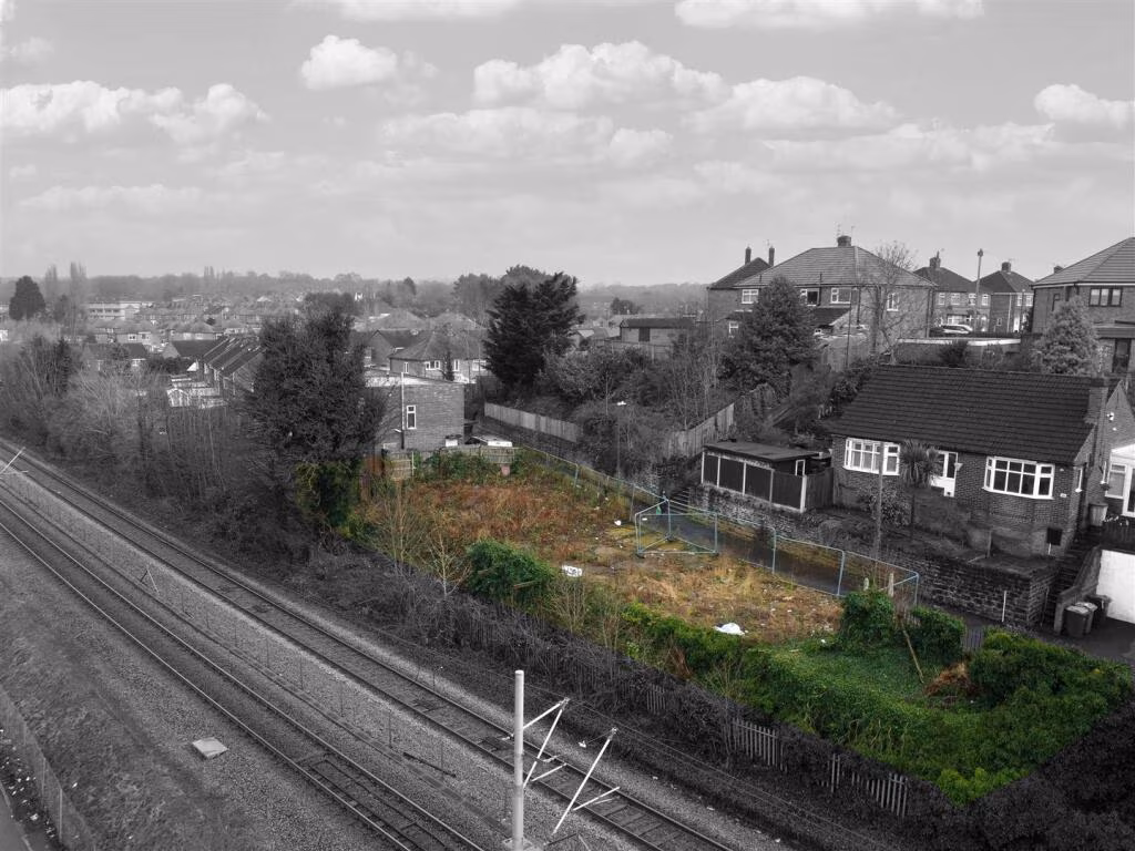
Detected Visual Features
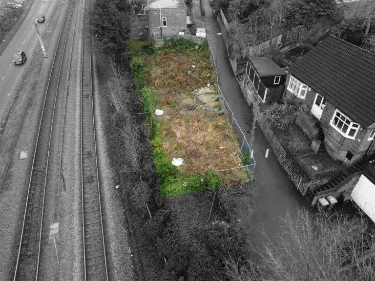
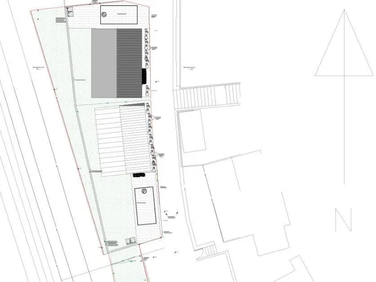
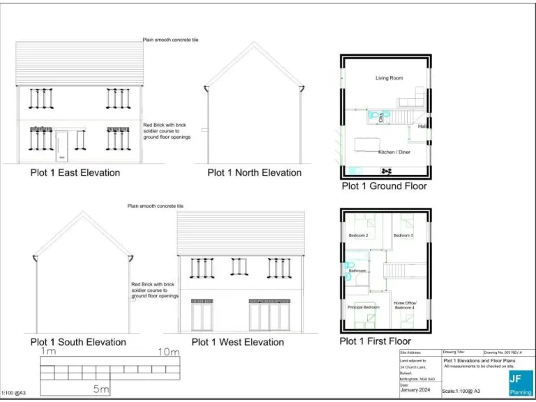
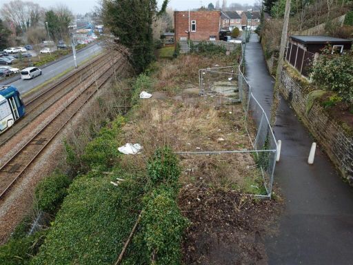
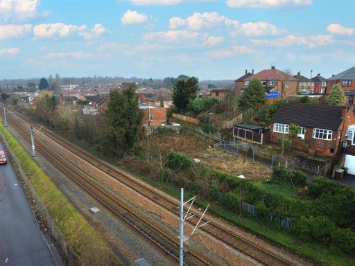
- land plot
- development opportunity
- vacant lot
- residential area
- close to railway
- overgrown
- neglected
- fencing
- investment
- potential
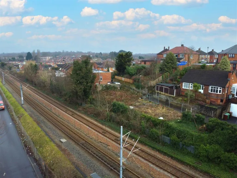
- railway proximity
- fenced plot
- urban area
- potential building site
- investment opportunity
Nearby Schools
- Park Vale Academy
- Butler's Hill Infant and Nursery School
- Broomhill Junior School
- Whitemoor Academy (Primary and Nursery)
- Ellis Guilford School
- Rosslyn Park Primary and Nursery School
- Horsendale Primary School
- Green Crescent School
- Our Lady of Perpetual Succour Catholic Primary School
- Hempshill Hall Primary School
- Crabtree Farm Primary School
- Springfield Academy
- Hawthorne Primary and Nursery School
- Heathfield Primary and Nursery School
- Henry Whipple Primary School
- Southglade Primary and Nursery School
- Bulwell St Mary's Primary and Nursery School
- The Bulwell Academy
- Rise Park Primary and Nursery School
- Bluecoat Aspley Academy
- Old Basford School
- Cantrell Primary and Nursery School
- Snape Wood Primary and Nursery School
- Rufford Primary and Nursery School
- Westglade Primary School
- Stanstead Nursery and Primary School
- Ambleside Primary School
- Southwark Primary School
Nearest General Shops
- Id: 218880844
- Tags:
- Addr:
- City: Nottingham
- Housenumber: 36-48
- Postcode: NG6 8EW
- Street: Main Street
- Brand: Wilko
- Brand:wikidata: Q8002536
- Brand:wikipedia: en:Wilko (retailer)
- Contact:
- Website: https://stores.wilko.com/gb/nottingham/36-48-main-street
- Fhrs:
- Name: Wilko
- Old_name: Wilkinson
- Shop: variety_store
- Source: survey
- Source:addr: NCC Open Data
- Source:outline: Bing
- TagsNormalized:
- Lat: 53.0008684
- Lon: -1.1959511
- FullGeoHash: gcrjsb90kmfp
- PartitionGeoHash: gcrj
- Images:
- FoodStandards:
- Id: 217205
- FHRSID: 217205
- LocalAuthorityBusinessID: 49446
- BusinessName: Wilko
- BusinessType: Retailers - other
- BusinessTypeID: 4613
- AddressLine1: null
- AddressLine2: 36-48 Main Street
- AddressLine3: null
- AddressLine4: Nottingham
- PostCode: NG6 8EW
- RatingValue: 5
- RatingKey: fhrs_5_en-GB
- RatingDate: 2019-05-16
- LocalAuthorityCode: 899
- LocalAuthorityName: Nottingham City
- LocalAuthorityWebSite: http://www.nottinghamcity.gov.uk/foodsafety
- LocalAuthorityEmailAddress: food.enforcement@nottinghamcity.gov.uk
- Scores:
- Hygiene: 0
- Structural: 0
- ConfidenceInManagement: 0
- NewRatingPending: false
- Geocode:
- Longitude: -1.19613500000000
- Latitude: 53.00162600000000
- Distance: 117.4
,- Id: 4232604988
- Tags:
- Addr:
- Estate_agent: lettings_agent
- Level: 0
- Name: Belvoir!
- Shop: estate_agent
- Source: survey
- TagsNormalized:
- Lat: 53.0001241
- Lon: -1.1958632
- FullGeoHash: gcrjsb3hn75z
- PartitionGeoHash: gcrj
- Images:
- FoodStandards: null
- Distance: 112.1
,- Id: 4232608193
- Tags:
- Addr:
- Level: 0
- Name: Regency Mouldings & Fireplaces Ltd
- Shop: fireplace
- Source: survey
- TagsNormalized:
- Lat: 53.0001985
- Lon: -1.1957321
- FullGeoHash: gcrjsb3k93jd
- PartitionGeoHash: gcrj
- Images:
- FoodStandards: null
- Distance: 101
}
Nearest Religious buildings
- Id: 221233063
- Tags:
- Addr:
- City: Nottingham
- Postcode: NG6 8ET
- Street: Main Street
- Amenity: place_of_worship
- Building: church
- Name: Mount Zion Seventh Day Church of God
- Religion: christian
- Source: survey
- TagsNormalized:
- place of worship
- church
- christian
- Lat: 53.0028097
- Lon: -1.195616
- FullGeoHash: gcrjsbc7spu5
- PartitionGeoHash: gcrj
- Images:
- FoodStandards: null
- Distance: 271.4
,- Id: 280261954
- Tags:
- Amenity: grave_yard
- Denomination: anglican
- Landuse: religious
- Religion: christian
- TagsNormalized:
- grave yard
- anglican
- religious
- christian
- Lat: 53.0000336
- Lon: -1.1933879
- FullGeoHash: gcrjsb758437
- PartitionGeoHash: gcrj
- Images:
- FoodStandards: null
- Distance: 80.4
,- Id: 280261903
- Tags:
- Addr:
- City: Nottingham
- Housename: St Mary's Church
- Postcode: NG6 9AF
- Street: Highbury Road
- Alt_name: The Parish Church of St Mary the Virgin and All Souls Bulwell
- Amenity: place_of_worship
- Building: church
- Denomination: anglican
- Fhrs:
- Listed_status: Grade II
- Name: St Mary's Church
- Polling_station: 20190308
- Religion: christian
- Source: NCC_OpenData (OGL - Open Government Licence);survey
- Source:area: Bing
- Source:listed_status: English Heritage
- Wikidata: Q5117303
- Wikipedia: en:Church of St Mary the Virgin and All Souls, Bulwell
- TagsNormalized:
- place of worship
- church
- anglican
- christian
- Lat: 52.9999632
- Lon: -1.1939796
- FullGeoHash: gcrjsb6e4m0r
- PartitionGeoHash: gcrj
- Images:
- FoodStandards:
- Id: 896377
- FHRSID: 896377
- LocalAuthorityBusinessID: 71023
- BusinessName: St Mary The Virgin & All Souls Church
- BusinessType: Other catering premises
- BusinessTypeID: 7841
- AddressLine1: St Marys Church
- AddressLine2: Highbury Road
- AddressLine3: null
- AddressLine4: Nottingham
- PostCode: NG6 9AF
- RatingValue: 5
- RatingKey: fhrs_5_en-GB
- RatingDate: 2018-07-12
- LocalAuthorityCode: 899
- LocalAuthorityName: Nottingham City
- LocalAuthorityWebSite: http://www.nottinghamcity.gov.uk/foodsafety
- LocalAuthorityEmailAddress: food.enforcement@nottinghamcity.gov.uk
- Scores:
- Hygiene: 0
- Structural: 0
- ConfidenceInManagement: 0
- NewRatingPending: false
- Geocode:
- Longitude: -1.19334900000000
- Latitude: 52.99918000000000
- Distance: 63.5
}
Nearest Medical buildings
- Id: 4237927696
- Tags:
- Addr:
- City: Nottingham
- Place: Bulwell Riverside
- Postcode: NG6 8QJ
- Street: Main Street
- Amenity: doctors
- Healthcare: doctor
- Name: Leen View Surgery
- Source:
- Website: https://www.leenviewsurgery.co.uk/
- TagsNormalized:
- doctor
- doctors
- health
- healthcare
- surgery
- Lat: 52.9982237
- Lon: -1.1966786
- FullGeoHash: gcrjsb0952gy
- PartitionGeoHash: gcrj
- Images:
- FoodStandards: null
- Distance: 298.6
,- Id: 4237927697
- Tags:
- Addr:
- City: Nottingham
- Place: Bulwell Riverside
- Postcode: NG6 8QJ
- Street: Main Street
- Amenity: doctors
- Healthcare: doctor
- Name: Parkside Medical Practice
- Source:
- Website: https://www.parksidemedicalpractice.co.uk/
- TagsNormalized:
- doctor
- doctors
- health
- healthcare
- Lat: 52.9983399
- Lon: -1.1967054
- FullGeoHash: gcrjsb09dwxg
- PartitionGeoHash: gcrj
- Images:
- FoodStandards: null
- Distance: 288.7
,- Id: 4237927698
- Tags:
- Addr:
- City: Nottingham
- Place: Bulwell Riverside
- Postcode: NG6 8QJ
- Street: Main Street
- Amenity: pharmacy
- Healthcare: pharmacy
- Name: Riverside Pharmacy
- Source: survey
- Source:addr: interpolation
- TagsNormalized:
- Lat: 52.9984507
- Lon: -1.196802
- FullGeoHash: gcrjsb0d27r8
- PartitionGeoHash: gcrj
- Images:
- FoodStandards: null
- Distance: 282.3
,- Id: 282041383
- Tags:
- Addr:
- City: Nottingham
- Postcode: NG6 9AA
- Street: Station Road
- Amenity: doctors
- Building: yes
- Healthcare: doctor
- Name: Riverlyn Medical Centre
- Source:
- TagsNormalized:
- doctor
- doctors
- health
- healthcare
- Lat: 52.9996796
- Lon: -1.1962697
- FullGeoHash: gcrjsb2csbke
- PartitionGeoHash: gcrj
- Images:
- FoodStandards: null
- Distance: 159.8
}
Nearest Airports
- Id: 11359528
- Tags:
- Aerodrome: international
- Aerodrome:type: public
- Aeroway: aerodrome
- Iata: EMA
- Icao: EGNX
- Is_in: Castle Donington,England,UK
- Name: East Midlands Airport
- Old_name: RAF Castle Donington
- Operator: Manchester Airports Holdings Limited
- Operator:type: private
- Ref: EMA
- Type: multipolygon
- Website: https://www.eastmidlandsairport.com/
- Wikidata: Q8977
- Wikipedia: en:East Midlands Airport
- TagsNormalized:
- airport
- international airport
- Lat: 52.8281122
- Lon: -1.3322143
- FullGeoHash: gcrh99jfj1vh
- PartitionGeoHash: gcrh
- Images:
- FoodStandards: null
- Distance: 21282.3
}
Nearest Tourist attractions
- Id: 89203188
- Tags:
- Building: aviary
- Listed_status: Grade II
- Name: Aviary
- Source:
- Listed_status: English Heritage
- Tourism: aviary
- TagsNormalized:
- Lat: 52.9601082
- Lon: -1.1573567
- FullGeoHash: gcrjm9j4zxsq
- PartitionGeoHash: gcrj
- Images:
- FoodStandards: null
- Distance: 5127.5
,- Id: 209377353
- Tags:
- Addr:
- City: Nottingham
- Housenumber: 39
- Postcode: NG7 6BE
- Street: Gregory Boulevard
- Building: yes
- Fhrs:
- Museum: gallery
- Name: New Art Exchange
- Source: Bing
- Source:name: survey
- Tourism: museum
- Wheelchair: yes
- Wikidata: Q24993766
- TagsNormalized:
- Lat: 52.9659396
- Lon: -1.1684435
- FullGeoHash: gcrjm6jhvqc2
- PartitionGeoHash: gcrj
- Images:
- FoodStandards:
- Id: 217146
- FHRSID: 217146
- LocalAuthorityBusinessID: 44540
- BusinessName: The New Art Exchange
- BusinessType: Other catering premises
- BusinessTypeID: 7841
- AddressLine1: null
- AddressLine2: 39 Gregory Boulevard
- AddressLine3: null
- AddressLine4: Nottingham
- PostCode: NG7 6BE
- RatingValue: 5
- RatingKey: fhrs_5_en-GB
- RatingDate: 2022-09-14
- LocalAuthorityCode: 899
- LocalAuthorityName: Nottingham City
- LocalAuthorityWebSite: http://www.nottinghamcity.gov.uk/foodsafety
- LocalAuthorityEmailAddress: food.enforcement@nottinghamcity.gov.uk
- Scores:
- Hygiene: 0
- Structural: 5
- ConfidenceInManagement: 0
- NewRatingPending: false
- Geocode:
- Longitude: -1.16807300000000
- Latitude: 52.96606000000000
- Distance: 4214.9
,- Id: 6307651
- Tags:
- Addr:
- City: Nottingham
- Housenumber: 3
- Postcode: NG6 8SA
- Street: The Cliff
- Building: yes
- Guest_house: bed_and_breakfast
- Name: Rufford Court Bed & Breakfast
- Old_amenity: nursing_home
- Old_fhrs:
- Source: survey
- Source:addr: FHRS Open Data
- Tourism: guest_house
- Type: multipolygon
- TagsNormalized:
- Lat: 52.9894245
- Lon: -1.2018736
- FullGeoHash: gcrjkwkvf2dj
- PartitionGeoHash: gcrj
- Images:
- FoodStandards: null
- Distance: 1331.4
}
Nearest Hotels
- Id: 393911810
- Tags:
- Addr:
- City: Nottingham
- Housenumber: 432
- Postcode: NG8 5DQ
- Street: Nuthall Road
- Building: commercial
- Name: Commodore Hotel
- Old_fhrs:
- Source: survey
- Source:addr: NCC Open Data
- Tourism: hotel
- Website: http://commodorehotelnottingham.com/
- TagsNormalized:
- Lat: 52.9784849
- Lon: -1.1912019
- FullGeoHash: gcrjkukw4crk
- PartitionGeoHash: gcrj
- Images:
- FoodStandards: null
- Distance: 2456.7
,- Id: 136170454
- Tags:
- Addr:
- City: Nottingham
- Postcode: NG8 6AZ
- Street: Nuthall Road
- Brand: DoubleTree
- Brand:wikidata: Q2504643
- Brand:wikipedia: en:DoubleTree
- Building: yes
- Contact:
- Facebook: https://www.facebook.com/NottinghamGatewayHotel
- Instagram: https://www.instagram.com/doubletreenott/
- Linkedin: https://www.linkedin.com/company/doubletree-by-hilton-hotel-nottingham---gateway/
- Twitter: https://twitter.com/gateway_hotel
- Email: sales@nottinghamgatewayhotel.co.uk
- Fax: +44-115-9797167
- Fhrs:
- Name: DoubleTree by Hilton Hotel Nottingham - Gateway
- Official_name: DoubleTree by Hilton
- Operator: Hilton Worldwide
- Phone: +44 115 9794949
- Smoking: no
- Stars: 4
- Tourism: hotel
- Website: https://www.hilton.com/en/hotels/emanudi-doubletree-nottingham-gateway/?WT.mc_id=zELWAKN0EMEA1DT2DMH3LocalSearch4DGGenericx6EMANUDI
- Wheelchair: yes
- Wikidata: Q89882546
- TagsNormalized:
- Lat: 52.9861358
- Lon: -1.2009518
- FullGeoHash: gcrjktv6xg97
- PartitionGeoHash: gcrj
- Images:
- FoodStandards: null
- Distance: 1657.8
,- Id: 95262350
- Tags:
- Addr:
- City: Nottingham
- Postcode: NG8 6AS
- Street: Millennium Way West
- Brand: Premier Inn
- Brand:wikidata: Q2108626
- Brand:wikipedia: en:Premier Inn
- Building: yes
- Contact:
- Website: https://www.premierinn.com/gb/en/hotels/england/nottinghamshire/nottingham/nottingham-west.html
- Internet_access: wlan
- Internet_access:fee: customers
- Internet_access:operator: Virgin Media
- Internet_access:ssid: Premier Inn Free Wi-Fi
- Name: Premier Inn
- Source: survey
- Source:area: Bing
- Tourism: hotel
- TagsNormalized:
- Lat: 52.9881889
- Lon: -1.2077317
- FullGeoHash: gcrjkw0w9f3f
- PartitionGeoHash: gcrj
- Images:
- FoodStandards: null
- Distance: 1637.3
}
Tags
- land plot
- development opportunity
- vacant lot
- residential area
- close to railway
- overgrown
- neglected
- fencing
- investment
- potential
- vacant lot
- development opportunity
- railway proximity
- overgrown
- fenced plot
- urban area
- potential building site
- investment opportunity
Local Market Stats
- Average Price/sqft: £194
- Avg Income: £33500
- Rental Yield: 5.8%
- Social Housing: 23%
- Planning Success Rate: 97%
Similar Properties
 Land for sale in Land Between 32-36, Church Lane, Bulwell, Nottingham, Nottinghamshire NG6 9AD, NG6 — £89,500 • 1 bed • 1 bath
 Plot for sale in Church Lane, Bulwell, Nottingham, NG6 — £89,500 • 1 bed • 1 bath
 Land for sale in Land at Cernan Court, Nottingham, NG6 7AX, NG6 — £5,000 • 1 bed • 1 bath • 2500 ft²
 Land for sale in Land Adjacent to, 15 Aldrin Close, Nottingham, NG6 7AJ, NG6 — £8,000 • 1 bed • 1 bath
 Commercial property for sale in Old Town Hall, Station Road, Bulwell, Nottingham, NG6 9AA, NG6 — £475,000 • 1 bed • 1 bath • 13249 ft²
 Land for sale in Station House, Outram Street, Sutton-In-Ashfield, NG17 4AX, NG17 — £185,000 • 1 bed • 1 bath • 16989 ft²
Meta
- {
"@context": "https://schema.org",
"@type": "Residence",
"name": "Land for sale in Land Between 3236, Church Lane, Bulwell, N…",
"description": "",
"url": "https://propertypiper.co.uk/property/efbc059d-77f6-4239-95de-7a44a6f3f8a7",
"image": "https://image-a.propertypiper.co.uk/3bfd67c1-4c0f-4fb9-9393-77de4e1dc363-1024.jpeg",
"address": {
"@type": "PostalAddress",
"streetAddress": "16 CHURCH LANE BULWELL NOTTINGHAM",
"postalCode": "NG6 9AD",
"addressLocality": "Nottingham",
"addressRegion": "Nottingham North",
"addressCountry": "England"
},
"geo": {
"@type": "GeoCoordinates",
"latitude": 53.00049888469951,
"longitude": -1.1943082069176287
},
"numberOfRooms": 1,
"numberOfBathroomsTotal": 1,
"offers": {
"@type": "Offer",
"price": 89500,
"priceCurrency": "GBP",
"availability": "https://schema.org/InStock"
},
"additionalProperty": [
{
"@type": "PropertyValue",
"name": "Feature",
"value": "land plot"
},
{
"@type": "PropertyValue",
"name": "Feature",
"value": "development opportunity"
},
{
"@type": "PropertyValue",
"name": "Feature",
"value": "vacant lot"
},
{
"@type": "PropertyValue",
"name": "Feature",
"value": "residential area"
},
{
"@type": "PropertyValue",
"name": "Feature",
"value": "close to railway"
},
{
"@type": "PropertyValue",
"name": "Feature",
"value": "overgrown"
},
{
"@type": "PropertyValue",
"name": "Feature",
"value": "neglected"
},
{
"@type": "PropertyValue",
"name": "Feature",
"value": "fencing"
},
{
"@type": "PropertyValue",
"name": "Feature",
"value": "investment"
},
{
"@type": "PropertyValue",
"name": "Feature",
"value": "potential"
},
{
"@type": "PropertyValue",
"name": "Feature",
"value": "vacant lot"
},
{
"@type": "PropertyValue",
"name": "Feature",
"value": "development opportunity"
},
{
"@type": "PropertyValue",
"name": "Feature",
"value": "railway proximity"
},
{
"@type": "PropertyValue",
"name": "Feature",
"value": "overgrown"
},
{
"@type": "PropertyValue",
"name": "Feature",
"value": "fenced plot"
},
{
"@type": "PropertyValue",
"name": "Feature",
"value": "urban area"
},
{
"@type": "PropertyValue",
"name": "Feature",
"value": "potential building site"
},
{
"@type": "PropertyValue",
"name": "Feature",
"value": "investment opportunity"
}
]
}