ME15 7HD - 2 bedroom detached house for sale in Crompton Gardens, Maid…
View on Property Piper
2 bedroom detached house for sale in Crompton Gardens, Maidstone, ME15
Property Details
- Price: £400000
- Bedrooms: 2
- Bathrooms: 2
- Property Type: undefined
- Property SubType: undefined
Brochure Descriptions
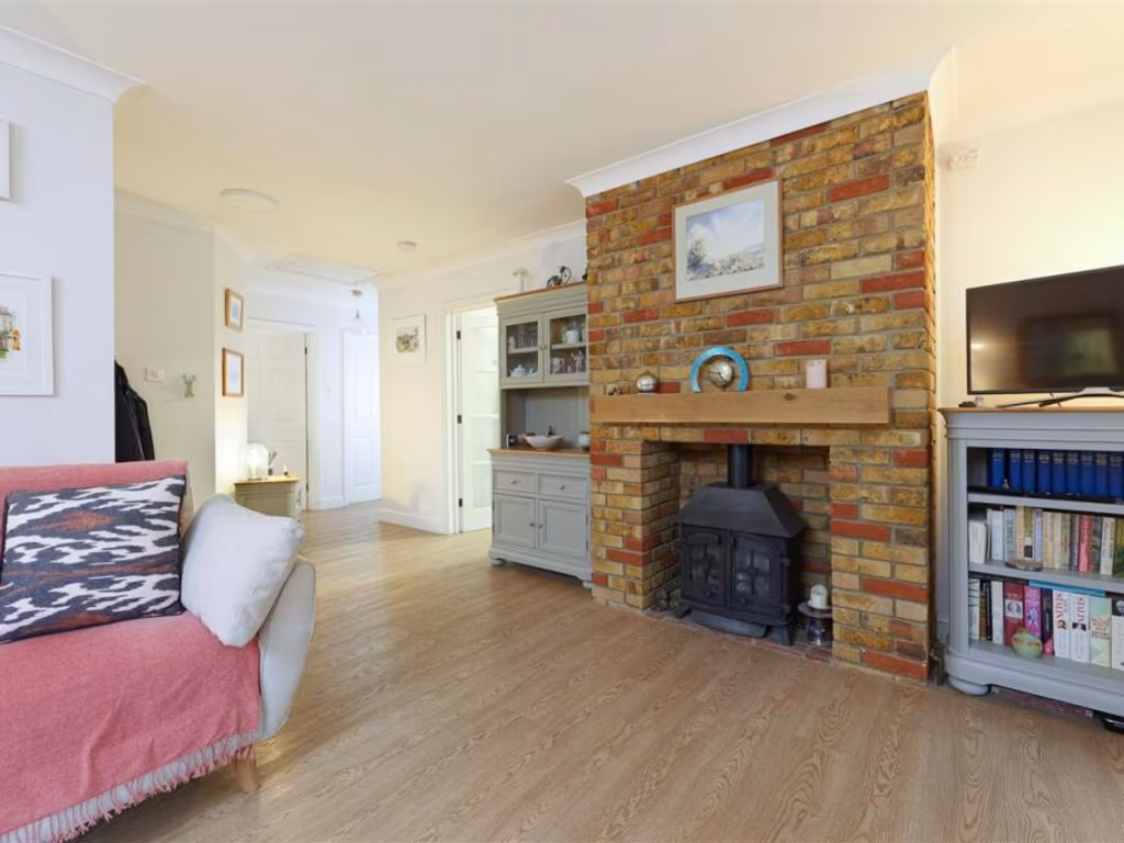
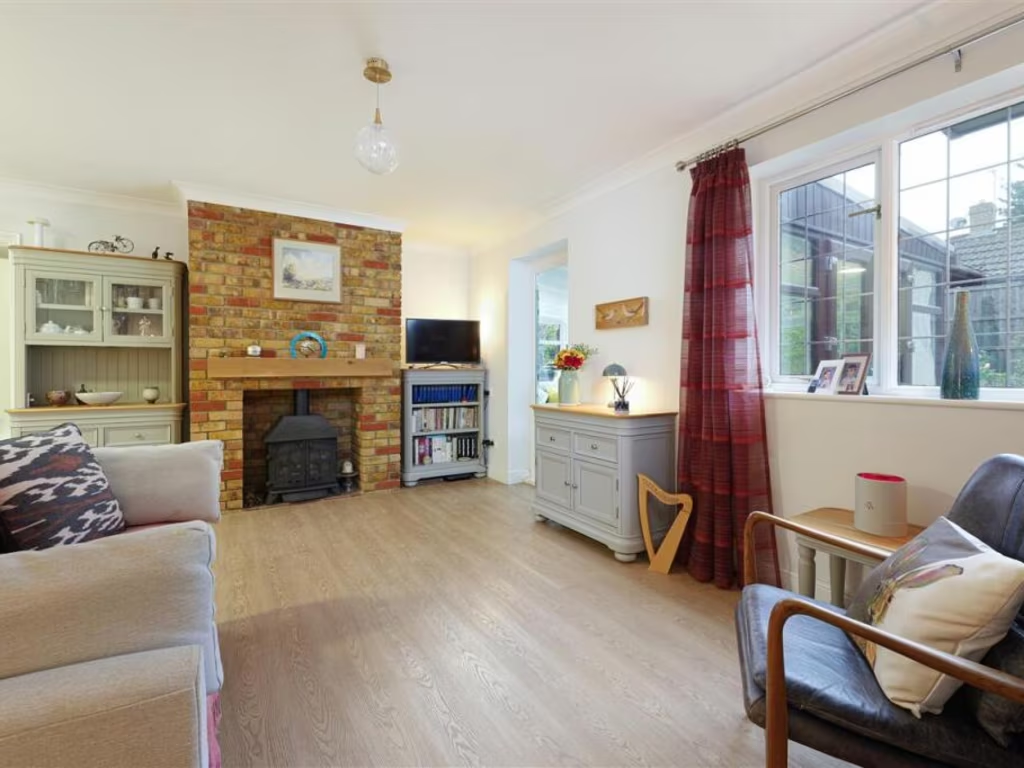
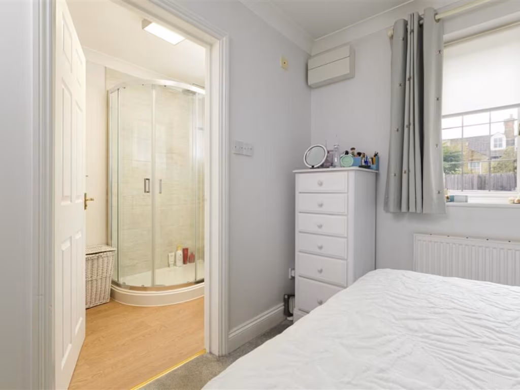
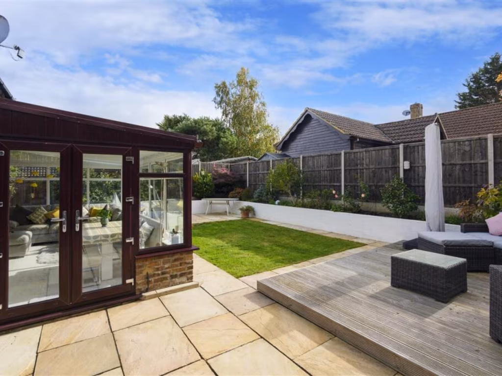
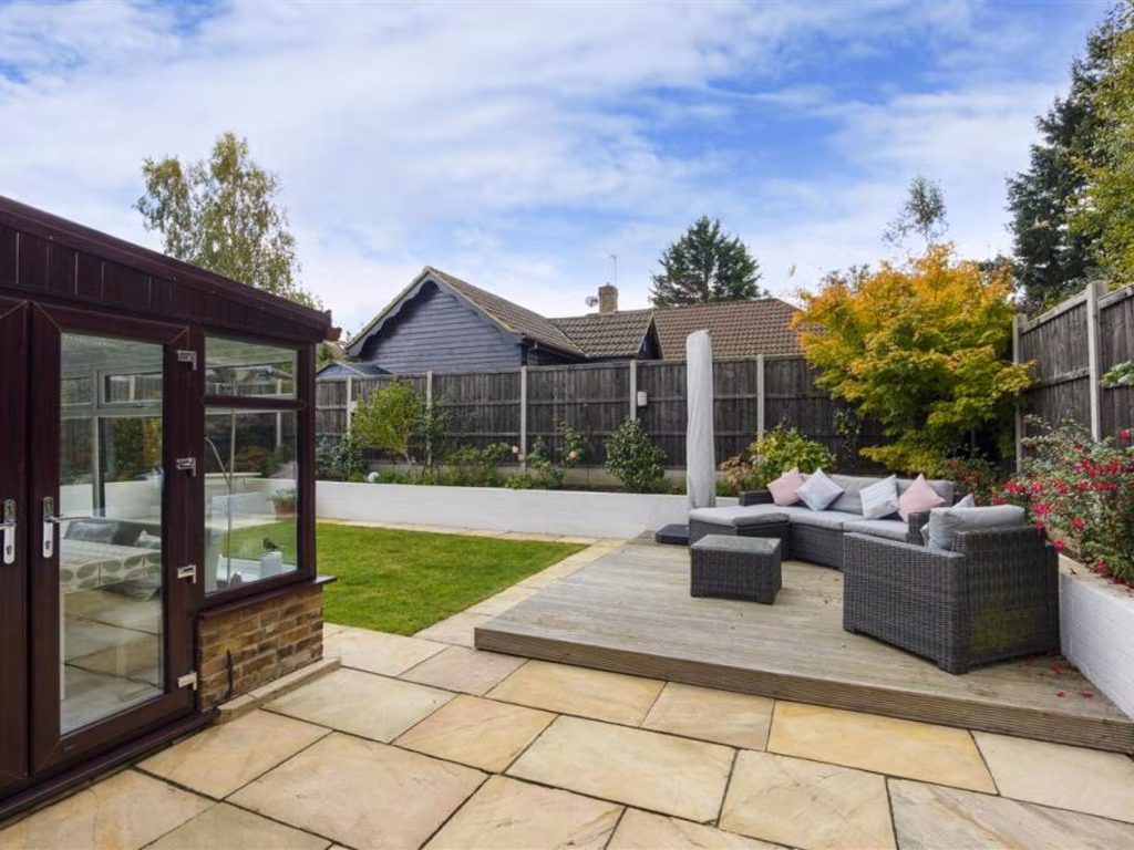
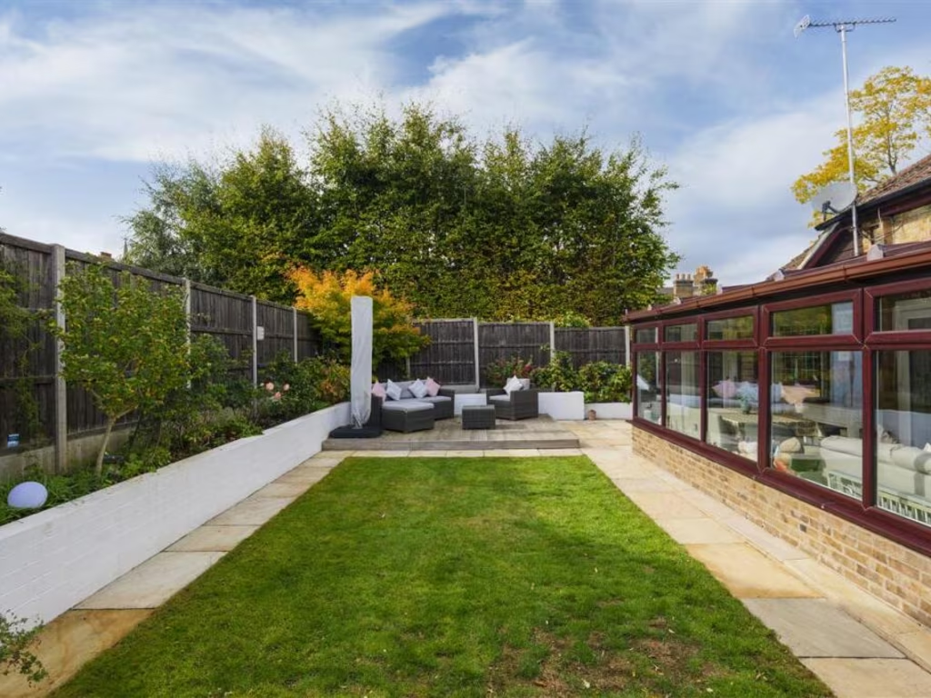
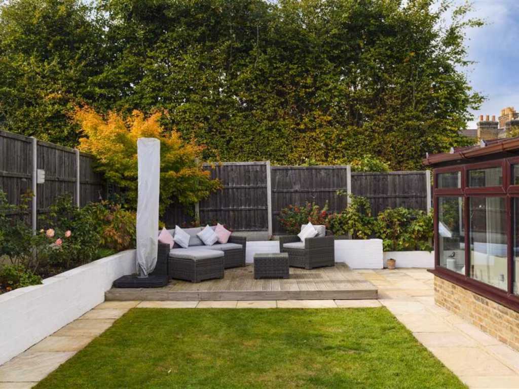
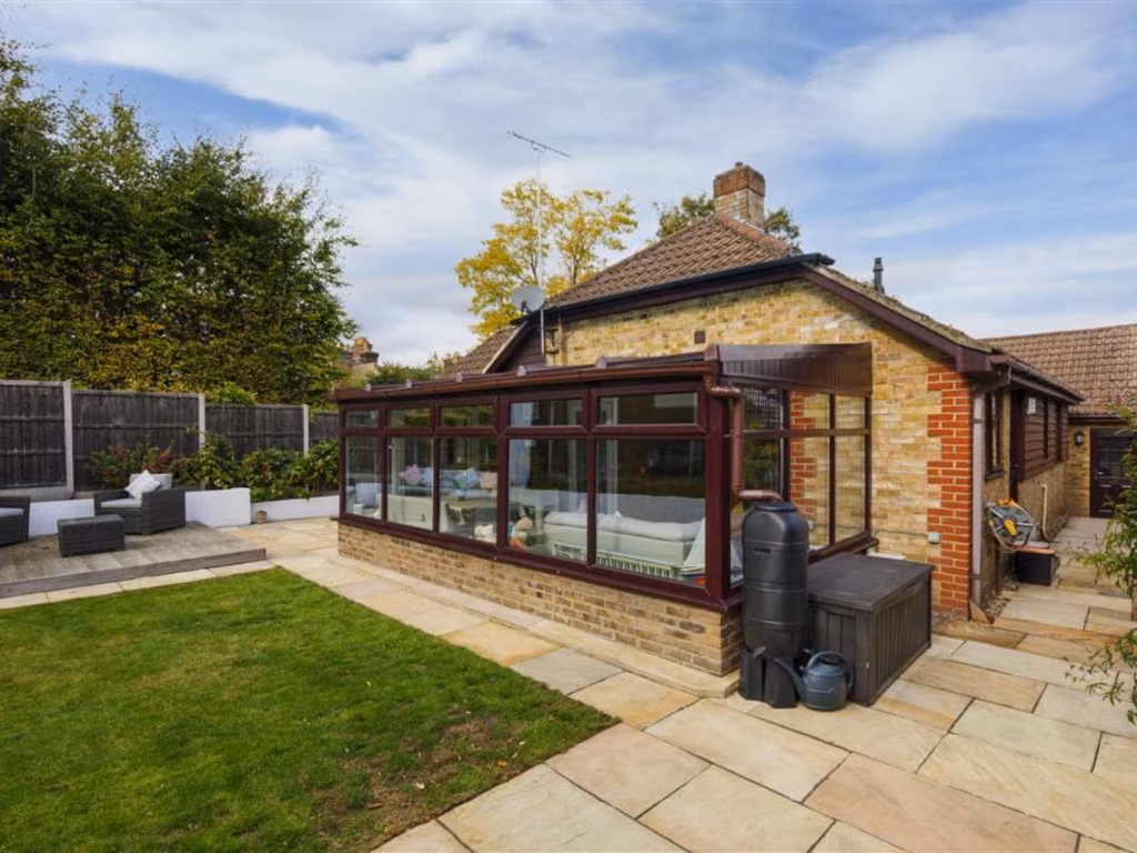
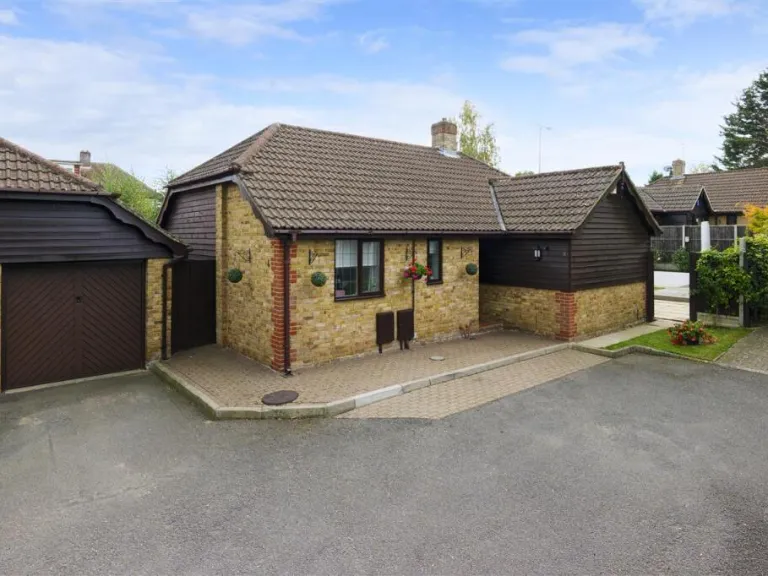
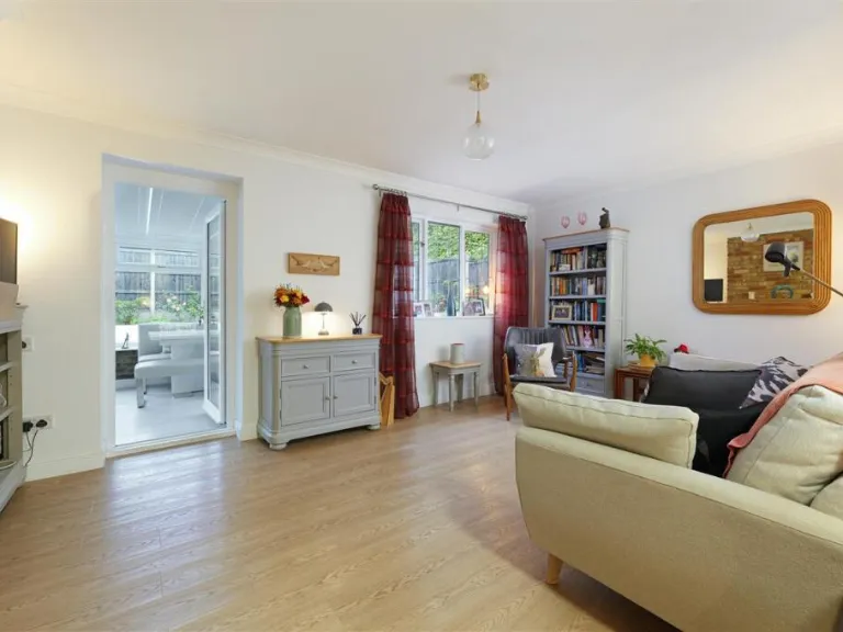
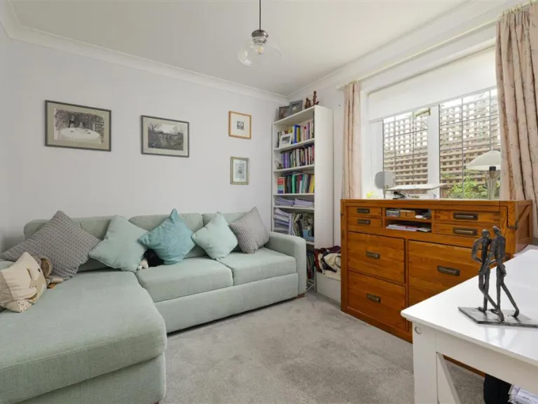
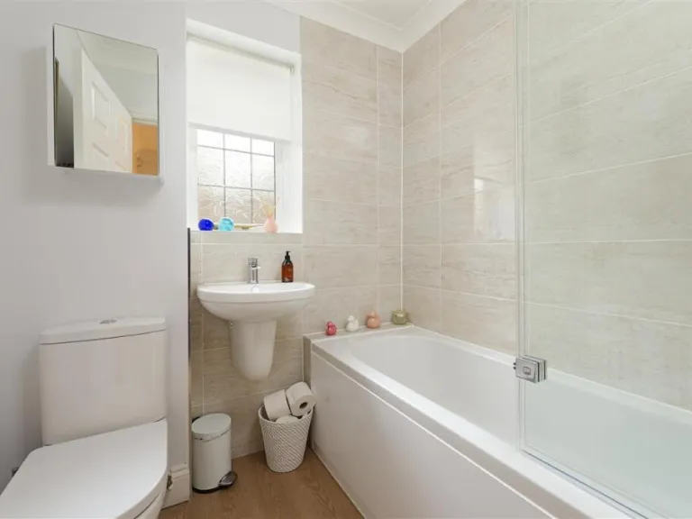
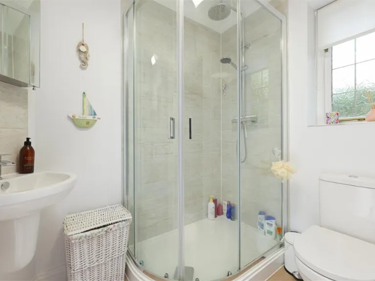
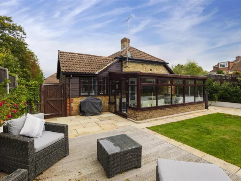
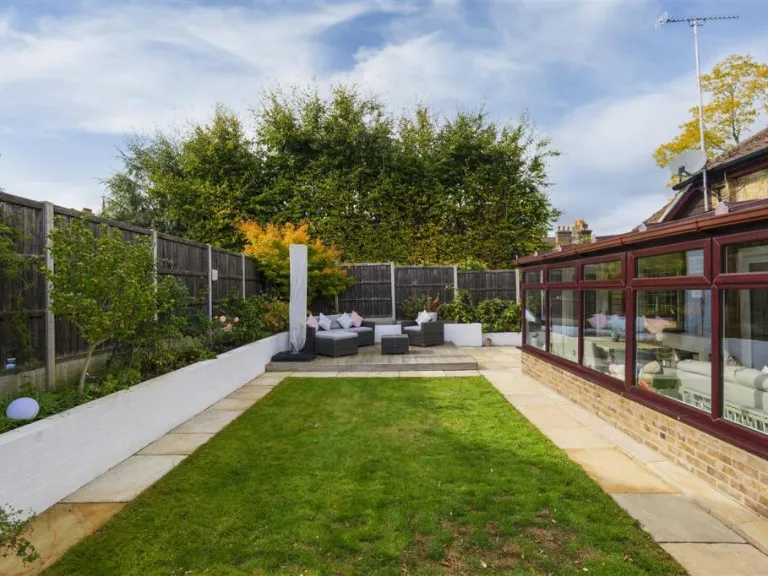
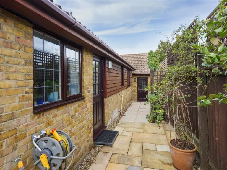
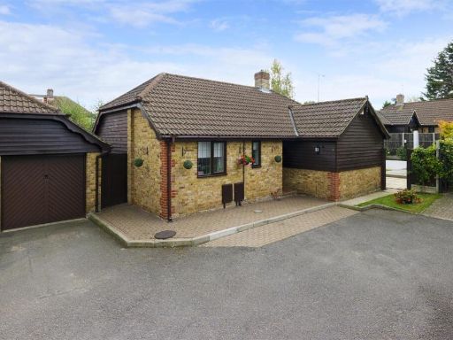
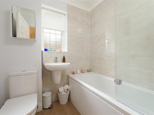
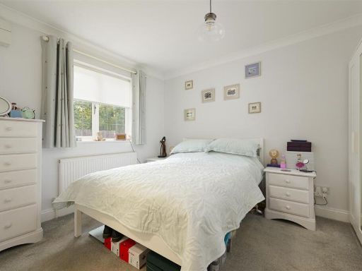
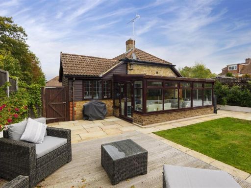
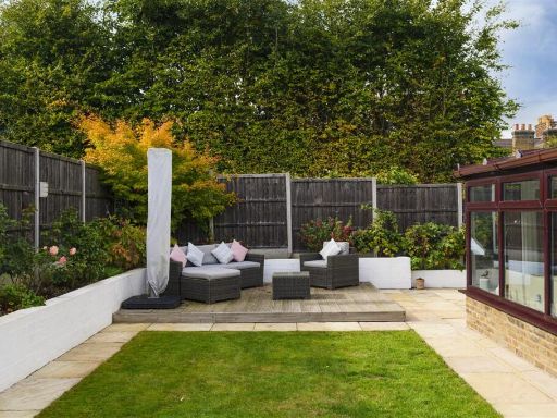
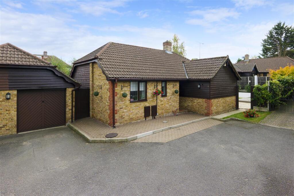
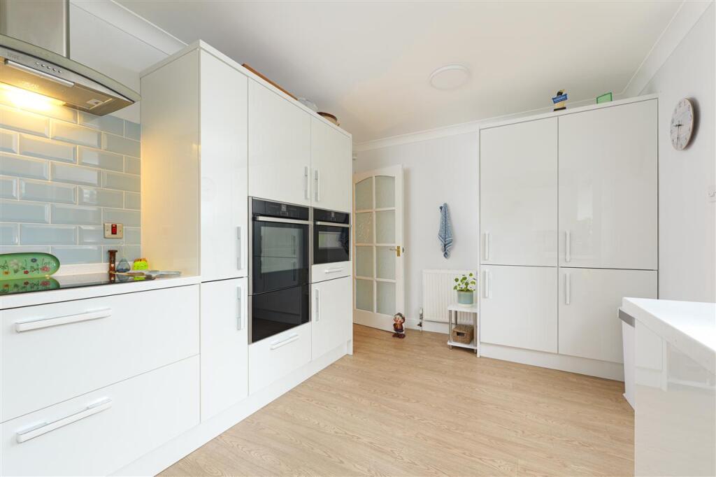
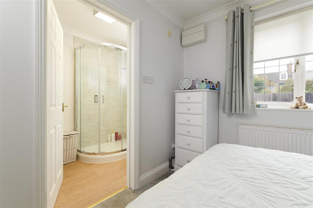
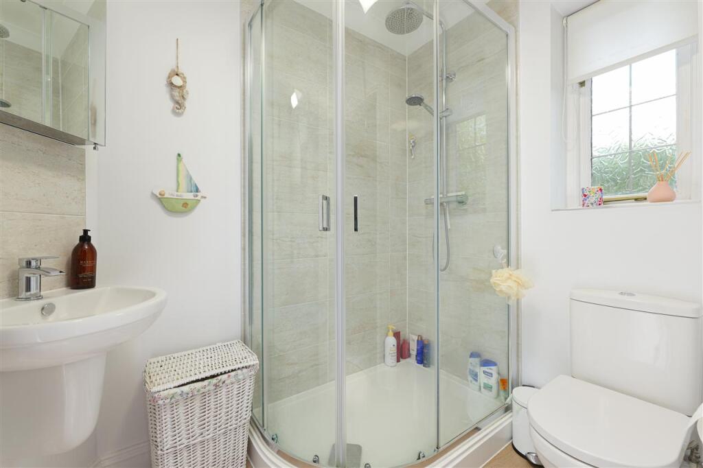
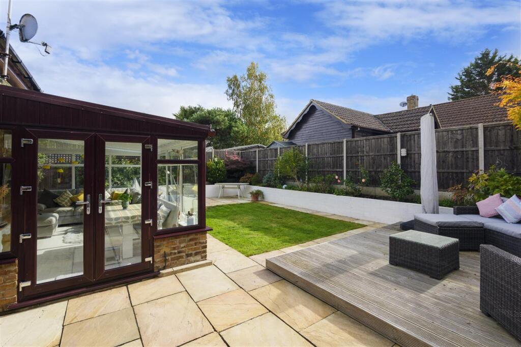
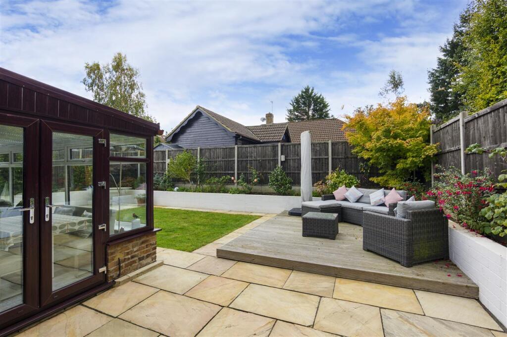
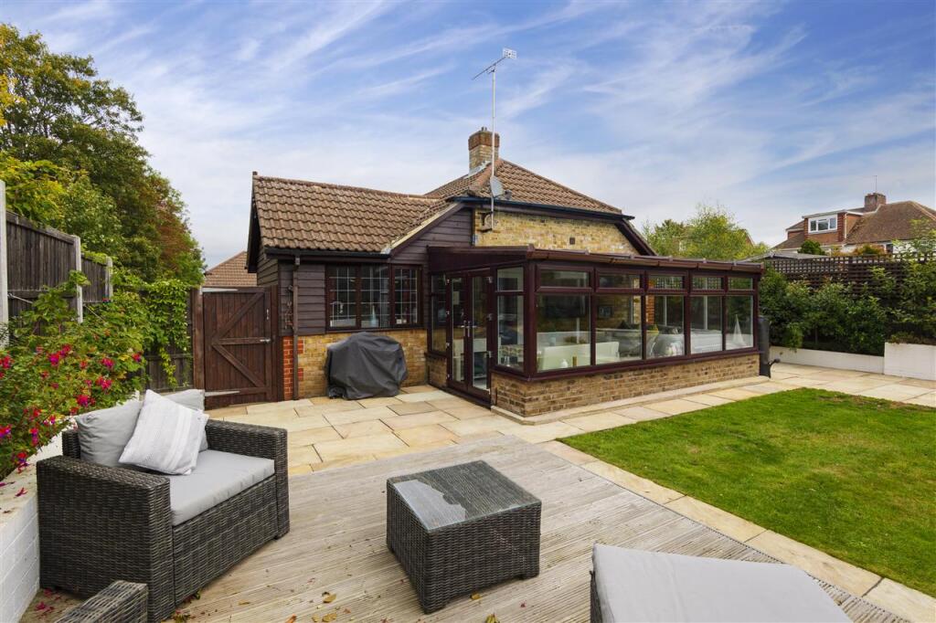
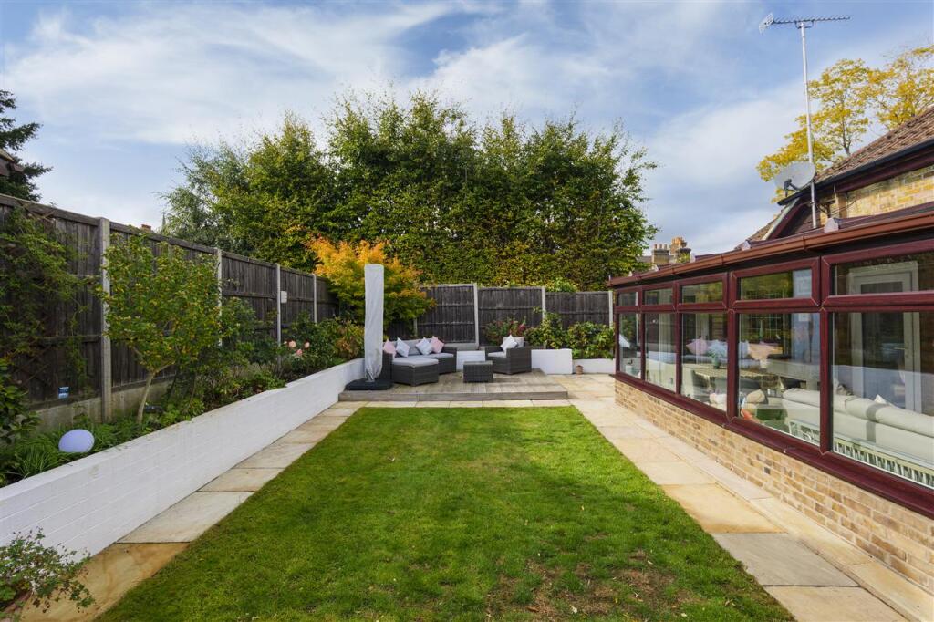
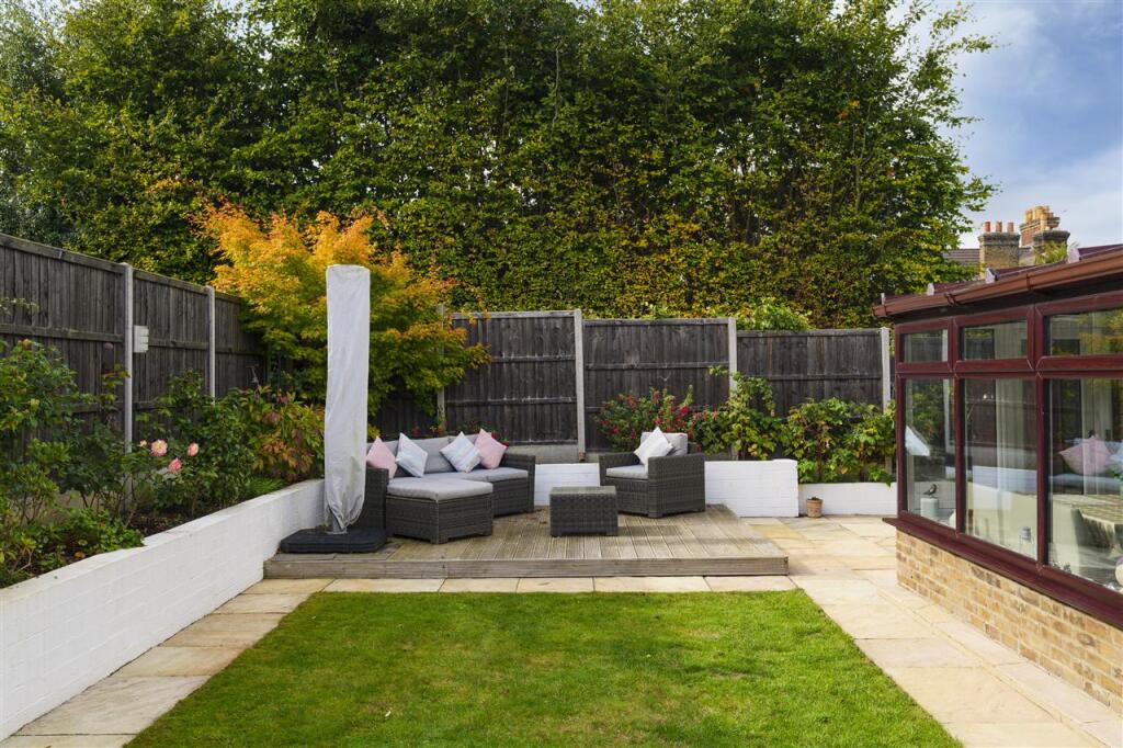
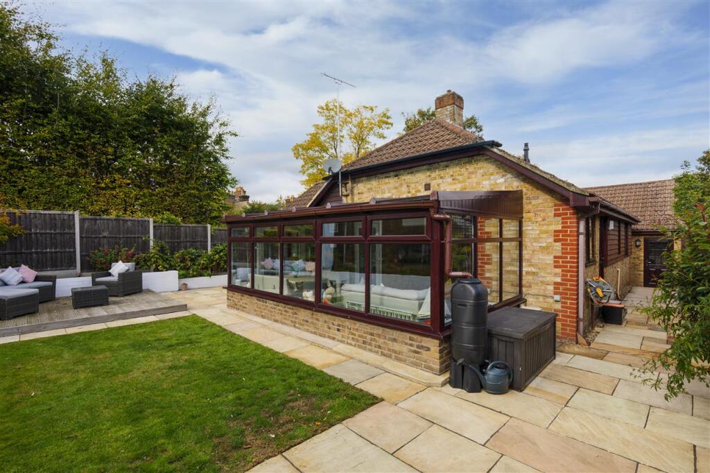
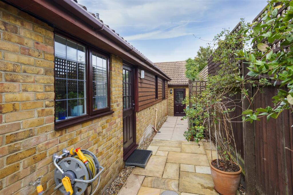
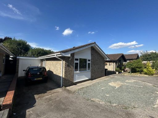
- Detached single‑storey bungalow of traditional brick construction with timber cladding to gable ends and a tiled roof, located on a small, quiet cul‑de‑sac. The property appears to offer two bedrooms, two bathrooms and two reception rooms (as noted on the brochure). A single garage with adjoining driveway provides off‑street parking. External space comprises a small paved forecourt/drive area and a modest front lawn/planting bed; rear garden size is not visible from the images but is likely small to average given the plot and neighbouring properties. Overall the dwelling is compact and suited to downsizers or a small family, presenting as a low‑maintenance suburban property with easy access to local amenities.
Image Descriptions
- single-story house 1980s bungalow
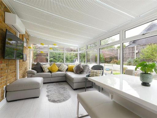
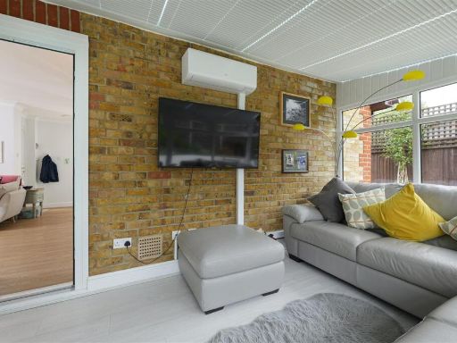
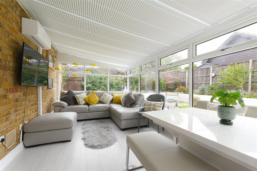
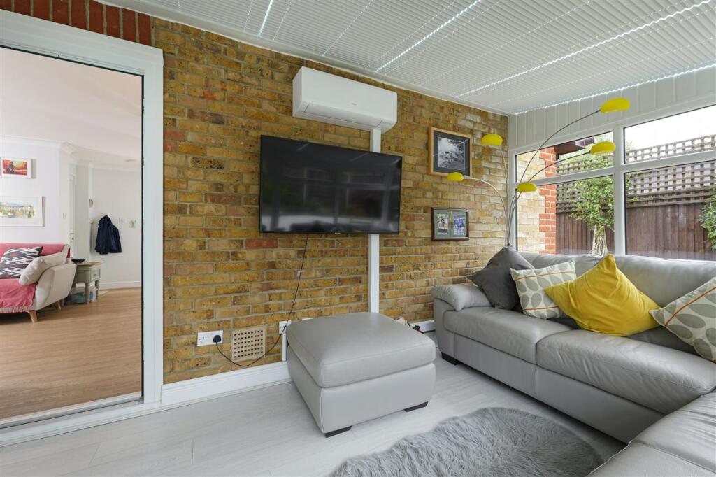
- conservatory modern
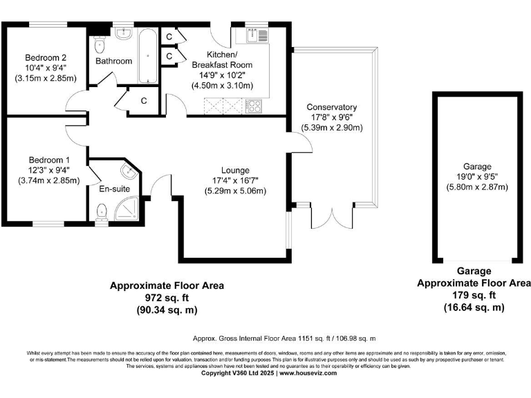
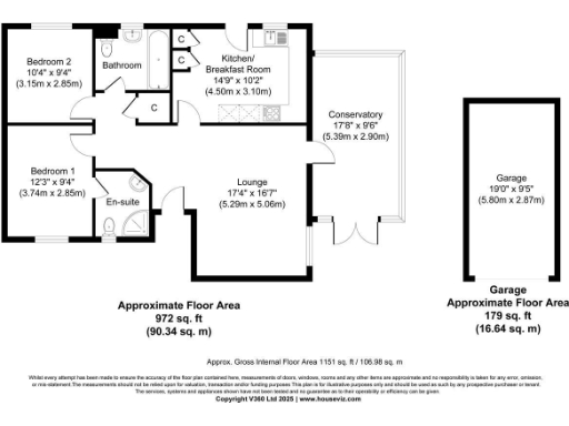
Rooms
- Bedroom 2:
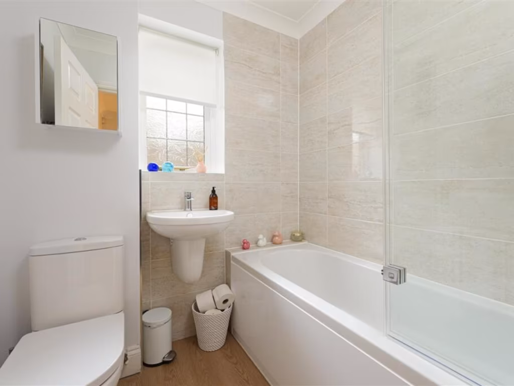
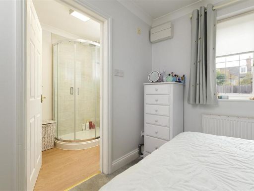
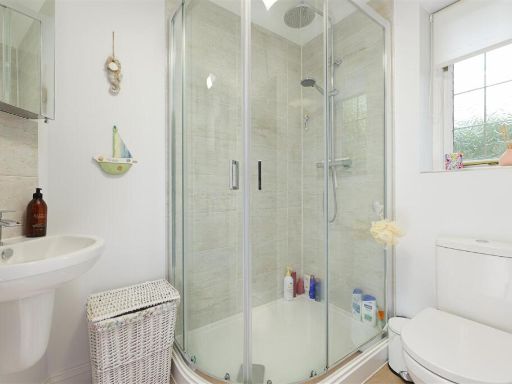
- Bathroom:
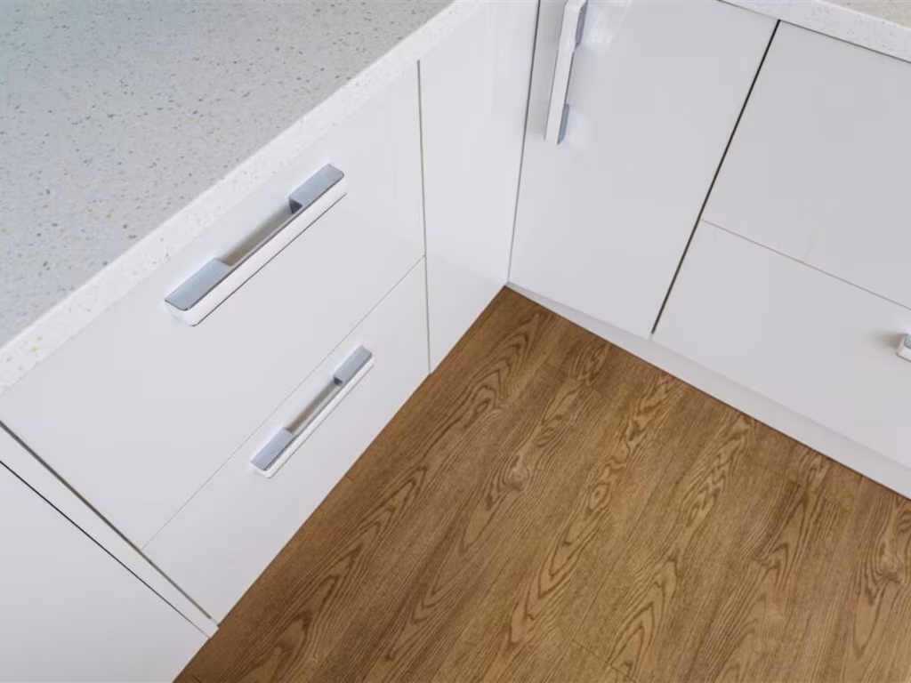
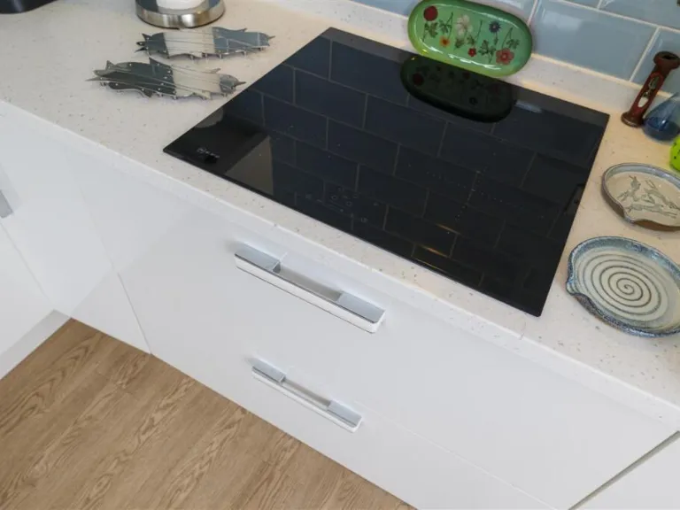
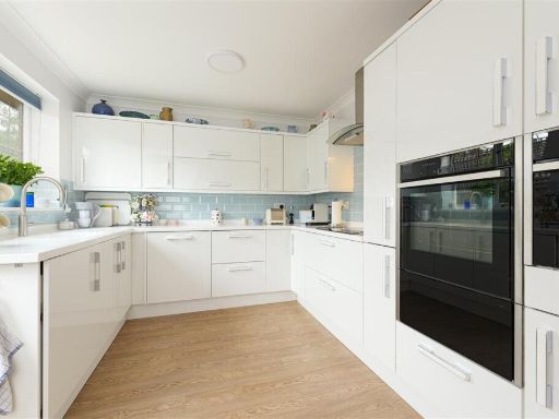
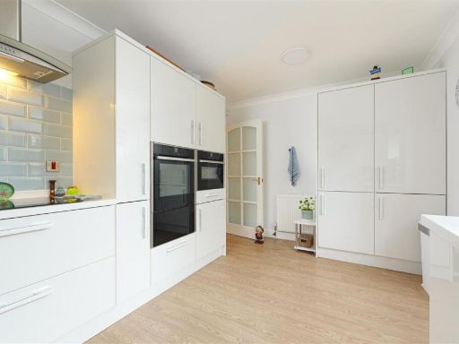
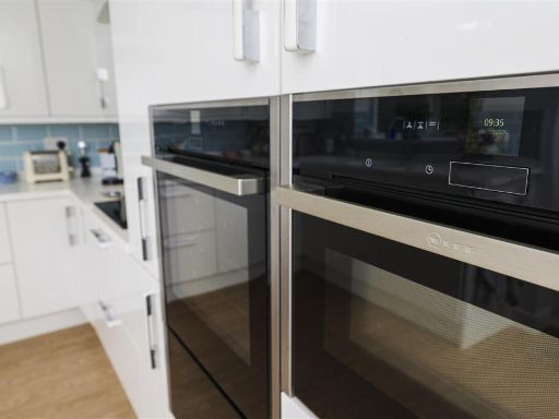
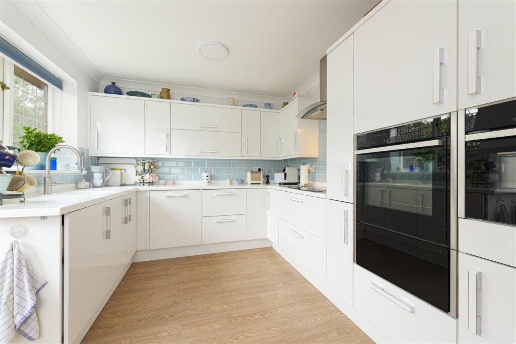
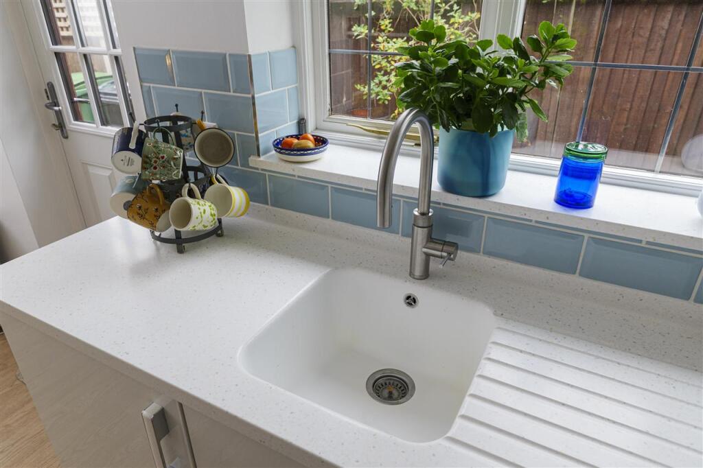
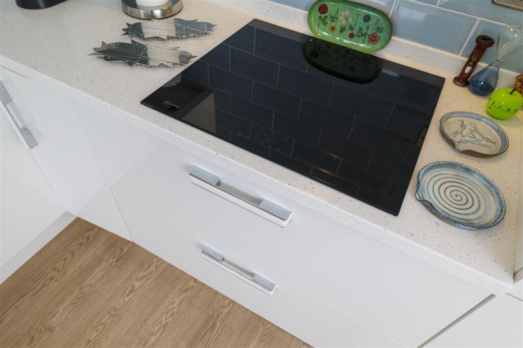
- Kitchen/ Breakfast Room:
- Conservatory:
- Bedroom 1:
- En-suite:
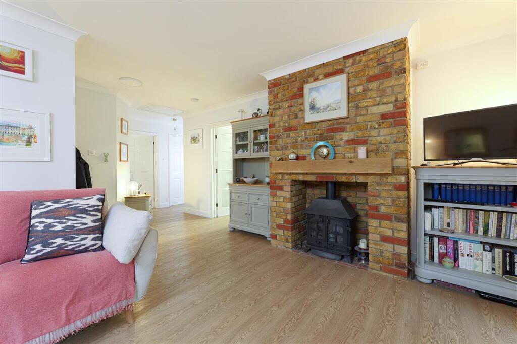
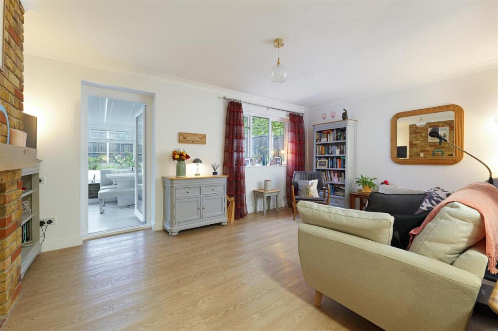
- Lounge:
Textual Property Features
Detected Visual Features
- 1980s
- bungalow
- garage
- brick exterior
- paved driveway
- well-kept
- single-story
- conservatory
- modern
- bright
- windows
- white
- garden view
- contemporary
- patio
- landscaped garden
EPC Details
- Fully double glazed
- Cavity wall, as built, insulated (assumed)
- Boiler and radiators, mains gas
- Low energy lighting in all fixed outlets
- Solid, limited insulation (assumed)
Nearby Schools
- Molehill Primary Academy
- South Borough Primary School
- St Michael's Church of England Infant School Maidstone
- School of Science and Technology Maidstone
- Maidstone, St John's Church of England Primary School
- MEPA ACADEMY
- Brunswick House Primary School
- Maidstone Grammar School for Girls
- Loose Primary School
- New Line Learning Academy
- Oaks Primary Academy
- Park Way Primary School
- Maidstone Grammar School
- Valley Invicta Primary School At East Borough
- The Maplesden Noakes School
- St Paul's Infant School
- Sandling Primary School
- Tiger Primary School
- Greenfields Community Primary School
- Archbishop Courtenay Primary School
- St Augustine Academy
- Valley Park School
- Invicta Grammar School
- Maidstone, St Michael's Church of England Junior School
- North Borough Junior School
- Oakwood Park Grammar School
Nearest Bars And Restaurants
- Id: 8311854835
- Tags:
- Amenity: fast_food
- Brand: Pizza Hut Delivery
- Brand:wikidata: Q107293079
- Brand:wikipedia: en:Pizza Hut
- Cuisine: pizza
- Name: Pizza Hut Delivery
- Takeaway: yes
- TagsNormalized:
- fast food
- food
- hut
- pizza
- pizza hut
- pizza hut delivery
- takeaway
- Lat: 51.2656479
- Lon: 0.5268708
- FullGeoHash: u107euxshcrm
- PartitionGeoHash: u107
- Images:
- FoodStandards: null
- Distance: 404.8
,- Id: 8311854836
- Tags:
- Amenity: fast_food
- Cuisine: fish_and_chips
- TagsNormalized:
- Lat: 51.2656485
- Lon: 0.5269566
- FullGeoHash: u107euxsncx3
- PartitionGeoHash: u107
- Images:
- FoodStandards: null
- Distance: 401.1
,- Id: 311413785
- Tags:
- Amenity: pub
- Name: The Pilot
- Wikidata: Q26519634
- TagsNormalized:
- Lat: 51.2698689
- Lon: 0.5260866
- FullGeoHash: u107evrhdsq8
- PartitionGeoHash: u107
- Images:
- FoodStandards: null
- Distance: 334.9
,- Id: 311413927
- Tags:
- Amenity: pub
- Name: The Cricketers
- TagsNormalized:
- Lat: 51.2705561
- Lon: 0.5280601
- FullGeoHash: u107sj888sqh
- PartitionGeoHash: u107
- Images:
- FoodStandards: null
- Distance: 277.4
,- Id: 311414109
- Tags:
- Amenity: pub
- Name: The Kingsley Arms
- TagsNormalized:
- Lat: 51.2692905
- Lon: 0.527102
- FullGeoHash: u107evrc627w
- PartitionGeoHash: u107
- Images:
- FoodStandards: null
- Distance: 244.6
}
Nearest General Shops
- Id: 8252707718
- Tags:
- Fixme: add proper shop tag
- Operator: simmonds
- Payment:
- Shop: yes
- TagsNormalized:
- Lat: 51.2657395
- Lon: 0.5302037
- FullGeoHash: u107shdhddkx
- PartitionGeoHash: u107
- Images:
- FoodStandards: null
- Distance: 311.6
,- Id: 979570444
- Tags:
- Brand: Halfords Autocentre
- Brand:wikidata: Q5641894
- Brand:wikipedia: en:Halfords Autocentre
- Building: yes
- Name: Halfords Autocentre
- Shop: car_repair
- TagsNormalized:
- autocentre
- halfords
- halfords autocentre
- car repair
- repair
- shop
- Lat: 51.2687284
- Lon: 0.5267799
- FullGeoHash: u107evptfzet
- PartitionGeoHash: u107
- Images:
- FoodStandards: null
- Distance: 253.2
,- Id: 888479797
- Tags:
- TagsNormalized:
- Lat: 51.2678629
- Lon: 0.5281716
- FullGeoHash: u107sj08gq36
- PartitionGeoHash: u107
- Images:
- FoodStandards: null
- Distance: 172.7
}
Nearest Grocery shops
- Id: 9723891167
- Tags:
- Name: Miller Food and Wine
- Shop: convenience
- TagsNormalized:
- Lat: 51.2705256
- Lon: 0.5251145
- FullGeoHash: u107evw2kn9y
- PartitionGeoHash: u107
- Images:
- FoodStandards: null
- Distance: 429.3
,- Id: 880687310
- Tags:
- Addr:
- City: Maidstone
- Housenumber: 1
- Street: Loose Road
- Brand: Co-op Food
- Brand:wikidata: Q3277439
- Brand:wikipedia: en:Co-op Food
- Building: yes
- Name: Co-op Food
- Shop: convenience
- Website: https://www.coop.co.uk/store-finder/ME15-7BW/1-loose-road
- TagsNormalized:
- co-op
- co-op food
- food
- convenience
- shop
- Lat: 51.2660413
- Lon: 0.5274024
- FullGeoHash: u107sh8n36g8
- PartitionGeoHash: u107
- Images:
- FoodStandards: null
- Distance: 347.6
,- Id: 4215630492
- Tags:
- Name: Kingsleys
- Shop: convenience
- TagsNormalized:
- Lat: 51.2678625
- Lon: 0.528244
- FullGeoHash: u107sj08uyr2
- PartitionGeoHash: u107
- Images:
- FoodStandards: null
- Distance: 168.2
}
Nearest Religious buildings
- Id: 152473826
- Tags:
- Amenity: place_of_worship
- Building: church
- Denomination: anglican
- Name: All Saints' Church
- Religion: christian
- Wikidata: Q4729500
- Wikipedia: en:All Saints Church, Maidstone
- TagsNormalized:
- place of worship
- church
- anglican
- christian
- Lat: 51.27069
- Lon: 0.5216285
- FullGeoHash: u107evec6v66
- PartitionGeoHash: u107
- Images:
- FoodStandards: null
- Distance: 655.8
,- Id: 311414278
- Tags:
- Amenity: place_of_worship
- Denomination: baptist
- Name: Maidstone Baptist Church
- Religion: christian
- TagsNormalized:
- place of worship
- baptist
- church
- christian
- Lat: 51.2705398
- Lon: 0.523008
- FullGeoHash: u107evsbdcr4
- PartitionGeoHash: u107
- Images:
- FoodStandards: null
- Distance: 560.7
,- Id: 882313462
- Tags:
- Amenity: place_of_worship
- Building: church
- Denomination: anglican
- Name: St Philip's Church
- Religion: christian
- Wikidata: Q105092614
- TagsNormalized:
- place of worship
- church
- anglican
- christian
- Lat: 51.2673353
- Lon: 0.5284496
- FullGeoHash: u107shbvcgbx
- PartitionGeoHash: u107
- Images:
- FoodStandards: null
- Distance: 190.9
}
Nearest Leisure Facilities
- Id: 311414058
- Tags:
- Leisure: sports_centre
- Name: The Mote Cricket Club
- Sport: cricket
- TagsNormalized:
- sports
- sports centre
- leisure
- cricket
- club
- Lat: 51.2676358
- Lon: 0.5350476
- FullGeoHash: u107shvxeebr
- PartitionGeoHash: u107
- Images:
- FoodStandards: null
- Distance: 338.2
,- Id: 311414007
- Tags:
- Leisure: sports_centre
- Name: Mote Squash Club
- Sport: squash
- TagsNormalized:
- sports
- sports centre
- leisure
- squash
- club
- Lat: 51.2679849
- Lon: 0.5350476
- FullGeoHash: u107sjj9et06
- PartitionGeoHash: u107
- Images:
- FoodStandards: null
- Distance: 328.7
,- Id: 887641230
- Tags:
- Leisure: pitch
- Lit: no
- Sport: soccer
- Surface: asphalt
- TagsNormalized:
- Lat: 51.2667489
- Lon: 0.5278905
- FullGeoHash: u107shb6kwxt
- PartitionGeoHash: u107
- Images:
- FoodStandards: null
- Distance: 265.1
,- Id: 377212338
- Tags:
- Designation: millennium_green
- Leisure: park
- Name: Collis (Millennium Green)
- Note: V1 as per the Natural England dataset.
- Source: Natural England
- TagsNormalized:
- Lat: 51.26653
- Lon: 0.5283753
- FullGeoHash: u107shbc0jc5
- PartitionGeoHash: u107
- Images:
- FoodStandards: null
- Distance: 264.3
,- Id: 887641232
- Tags:
- Access: yes
- Leisure: playground
- TagsNormalized:
- Lat: 51.2666234
- Lon: 0.5283861
- FullGeoHash: u107shbc8r30
- PartitionGeoHash: u107
- Images:
- FoodStandards: null
- Distance: 255.2
}
Nearest Tourist attractions
- Id: 311379094
- Tags:
- Name: Aylesbury Guest House
- Source: audio
- Tourism: guest_house
- TagsNormalized:
- Lat: 51.2743001
- Lon: 0.511617
- FullGeoHash: u107ewhw3w33
- PartitionGeoHash: u107
- Images:
- FoodStandards: null
- Distance: 1455.7
,- Id: 252113538
- Tags:
- Building: yes
- Name: Maidstone Museum
- Tourism: museum
- Wikidata: Q6735528
- Wikipedia: en:Maidstone Museum
- TagsNormalized:
- Lat: 51.2760603
- Lon: 0.5205925
- FullGeoHash: u107eye0dwmv
- PartitionGeoHash: u107
- Images:
- FoodStandards: null
- Distance: 1079.6
,- Id: 907788417
- Tags:
- Building: yes
- Museum: history
- Name: Museum of Carriages
- Tourism: museum
- Wikidata: Q17964487
- TagsNormalized:
- Lat: 51.2712896
- Lon: 0.5221334
- FullGeoHash: u107evshyt4g
- PartitionGeoHash: u107
- Images:
- FoodStandards: null
- Distance: 651.8
}
Nearest Train stations
- Id: 6688355479
- Tags:
- Name: East Farleigh
- Naptan:
- Network: National Rail
- Public_transport: station
- Railway: station
- Ref:
- Source: NPE
- Train: yes
- Wikidata: Q3065808
- Wikipedia: en:East Farleigh railway station
- TagsNormalized:
- Lat: 51.2552513
- Lon: 0.4844783
- FullGeoHash: u107e48z3pm5
- PartitionGeoHash: u107
- Images:
- FoodStandards: null
- Distance: 3520.8
,- Id: 6692612517
- Tags:
- Addr:
- Postcode: ME14 4PH
- Street: Ware Street
- Name: Bearsted
- Naptan:
- Network: National Rail
- Public_transport: station
- Railway: station
- Ref:
- Wikidata: Q2513832
- Wikipedia: en:Bearsted railway station
- TagsNormalized:
- Lat: 51.2759153
- Lon: 0.577672
- FullGeoHash: u107tnkxuerm
- PartitionGeoHash: u107
- Images:
- FoodStandards: null
- Distance: 3388.8
,- Id: 6688355481
- Tags:
- Name: Maidstone Barracks
- Naptan:
- Network: National Rail
- Postal_code: ME16 0SQ
- Public_transport: station
- Railway: station
- Ref:
- Wikidata: Q2913119
- Wikipedia: en:Maidstone Barracks railway station
- TagsNormalized:
- Lat: 51.2770433
- Lon: 0.5141731
- FullGeoHash: u107ewwqmjem
- PartitionGeoHash: u107
- Images:
- FoodStandards: null
- Distance: 1472.9
,- Id: 6692612534
- Tags:
- Name: Maidstone East
- Naptan:
- Network: National Rail
- Postal_code: ME14 1QN
- Public_transport: station
- Railway: station
- Ref:
- Wikidata: Q952299
- Wikipedia: en:Maidstone East railway station
- TagsNormalized:
- Lat: 51.2776262
- Lon: 0.5199007
- FullGeoHash: u107eyf9fd64
- PartitionGeoHash: u107
- Images:
- FoodStandards: null
- Distance: 1247
,- Id: 6688355480
- Tags:
- Name: Maidstone West
- Naptan:
- Network: National Rail
- Postal_code: ME16 8RJ
- Public_transport: station
- Railway: station
- Ref:
- Source: NPE
- Wikipedia: en:Maidstone West railway station
- TagsNormalized:
- Lat: 51.2703088
- Lon: 0.5157564
- FullGeoHash: u107etrx1yrb
- PartitionGeoHash: u107
- Images:
- FoodStandards: null
- Distance: 1038
}
Nearest Hotels
- Id: 238965514
- Tags:
- Access: customers
- Amenity: parking
- Capacity:
- Fee: no
- Name: Travelodge Maidstone Central Hotel
- Park_ride: no
- Parking: surface
- Source: survey,Bing
- TagsNormalized:
- Lat: 51.2729682
- Lon: 0.5166374
- FullGeoHash: u107evbnww0b
- PartitionGeoHash: u107
- Images:
- FoodStandards: null
- Distance: 1077.1
,- Id: 238965515
- Tags:
- Addr:
- City: Maidstone
- Street: Saint Peter's Street
- Brand: Travelodge
- Brand:wikidata: Q9361374
- Brand:wikipedia: en:Travelodge UK
- Building: hotel
- Fax: +44-1622-755558
- Internet_access: yes
- Internet_access:fee: customers
- Internet_access:ssid: Travelodge WiFi
- Layer: 1
- Name: Travelodge Maidstone Central Hotel
- Phone: +44 871 984 6442
- Source: survey,Bing
- Tourism: hotel
- Url: http://www.travelodge.co.uk/hotels/414/Maidstone-Central-hotel
- TagsNormalized:
- Lat: 51.272656
- Lon: 0.5166197
- FullGeoHash: u107evbhy5gd
- PartitionGeoHash: u107
- Images:
- FoodStandards: null
- Distance: 1062.8
,- Id: 255074827
- Tags:
- Addr:
- Name: Stone Court Hotel
- Tourism: hotel
- TagsNormalized:
- Lat: 51.2715769
- Lon: 0.5247389
- FullGeoHash: u107evwne69t
- PartitionGeoHash: u107
- Images:
- FoodStandards: null
- Distance: 519.2
}
Tags
- 1980s
- bungalow
- garage
- brick exterior
- paved driveway
- well-kept
- single-story
- conservatory
- modern
- bright
- windows
- white
- garden view
- contemporary
- well-kept
- patio
- landscaped garden
Local Market Stats
- Average Price/sqft: £359
- Avg Income: £51900
- Rental Yield: 4.3%
- Social Housing: 11%
- Planning Success Rate: 81%
AirBnB Data
- 1km average: £85/night
- Listings in 1km: 17
Similar Properties
 2 bedroom detached bungalow for sale in Beauworth Park, Maidstone, Kent, ME15 8EU, ME15 — £340,000 • 2 bed • 1 bath • 774 ft²
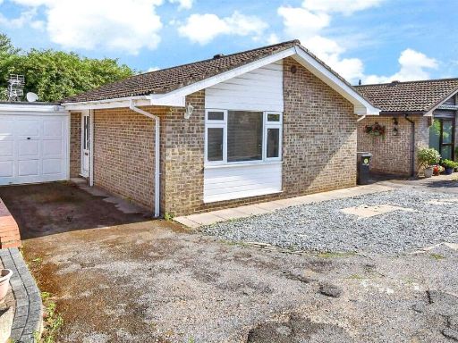 2 bedroom bungalow for sale in Beauworth Park, Maidstone, Kent, ME15 — £340,000 • 2 bed • 1 bath • 711 ft²
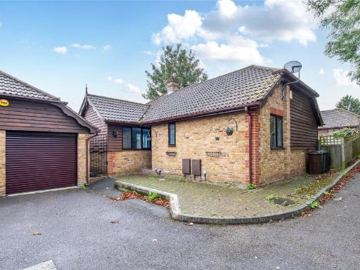 2 bedroom bungalow for sale in Crompton Gardens, Maidstone, Kent, ME15 — £375,000 • 2 bed • 2 bath • 872 ft²
 4 bedroom detached house for sale in Ufton Close, Maidstone, ME15 — £585,000 • 4 bed • 2 bath • 1543 ft²
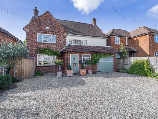 5 bedroom detached house for sale in Cedar Drive Barming, Maidstone, ME16 — £785,000 • 5 bed • 2 bath • 1699 ft²
 4 bedroom detached house for sale in Beech Hurst Close, Maidstone, ME15 — £500,000 • 4 bed • 2 bath • 1470 ft²
Meta
- {
"@context": "https://schema.org",
"@type": "Residence",
"name": "2 bedroom detached house for sale in Crompton Gardens, Maid…",
"description": "",
"url": "https://propertypiper.co.uk/property/e9861592-aea8-43b2-b2a4-ffd501825dbd",
"image": "https://image-a.propertypiper.co.uk/f27793dc-3c4c-449a-8e57-b5ac4019b80c-1024.jpeg",
"address": {
"@type": "PostalAddress",
"streetAddress": "4 CROMPTON GARDENS MAIDSTONE",
"postalCode": "ME15 7HD",
"addressLocality": "Maidstone",
"addressRegion": "Maidstone and The Weald",
"addressCountry": "England"
},
"geo": {
"@type": "GeoCoordinates",
"latitude": 51.26853909590341,
"longitude": 0.5304063537406241
},
"numberOfRooms": 2,
"numberOfBathroomsTotal": 2,
"floorSize": {
"@type": "QuantitativeValue",
"value": 1000,
"unitCode": "FTK"
},
"offers": {
"@type": "Offer",
"price": 400000,
"priceCurrency": "GBP",
"availability": "https://schema.org/InStock"
},
"additionalProperty": [
{
"@type": "PropertyValue",
"name": "Feature",
"value": "1980s"
},
{
"@type": "PropertyValue",
"name": "Feature",
"value": "bungalow"
},
{
"@type": "PropertyValue",
"name": "Feature",
"value": "garage"
},
{
"@type": "PropertyValue",
"name": "Feature",
"value": "brick exterior"
},
{
"@type": "PropertyValue",
"name": "Feature",
"value": "paved driveway"
},
{
"@type": "PropertyValue",
"name": "Feature",
"value": "well-kept"
},
{
"@type": "PropertyValue",
"name": "Feature",
"value": "single-story"
},
{
"@type": "PropertyValue",
"name": "Feature",
"value": "conservatory"
},
{
"@type": "PropertyValue",
"name": "Feature",
"value": "modern"
},
{
"@type": "PropertyValue",
"name": "Feature",
"value": "bright"
},
{
"@type": "PropertyValue",
"name": "Feature",
"value": "windows"
},
{
"@type": "PropertyValue",
"name": "Feature",
"value": "white"
},
{
"@type": "PropertyValue",
"name": "Feature",
"value": "garden view"
},
{
"@type": "PropertyValue",
"name": "Feature",
"value": "contemporary"
},
{
"@type": "PropertyValue",
"name": "Feature",
"value": "well-kept"
},
{
"@type": "PropertyValue",
"name": "Feature",
"value": "patio"
},
{
"@type": "PropertyValue",
"name": "Feature",
"value": "landscaped garden"
}
]
}
High Res Floorplan Images
Compatible Floorplan Images
FloorplanImages Thumbnail