S45 9JX - 3 bedroom semidetached house for sale in Bertrand Avenue, C…
View on Property Piper
3 bedroom semi-detached house for sale in Bertrand Avenue, Clay Cross, S45
Property Details
- Price: £200000
- Bedrooms: 3
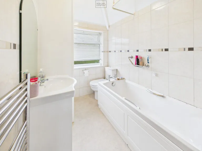
- Bathrooms: 1
- Property Type: undefined
- Property SubType: undefined
Image Descriptions
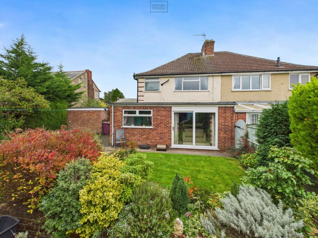
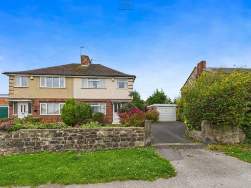
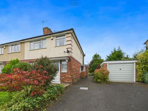
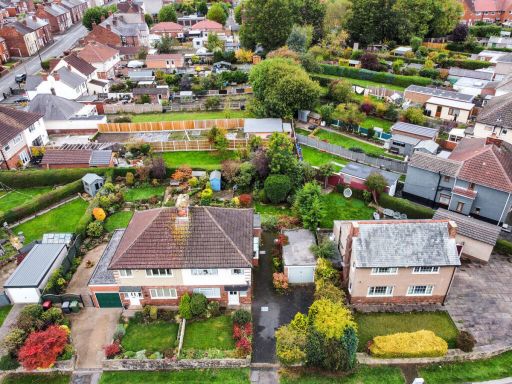
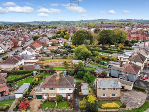
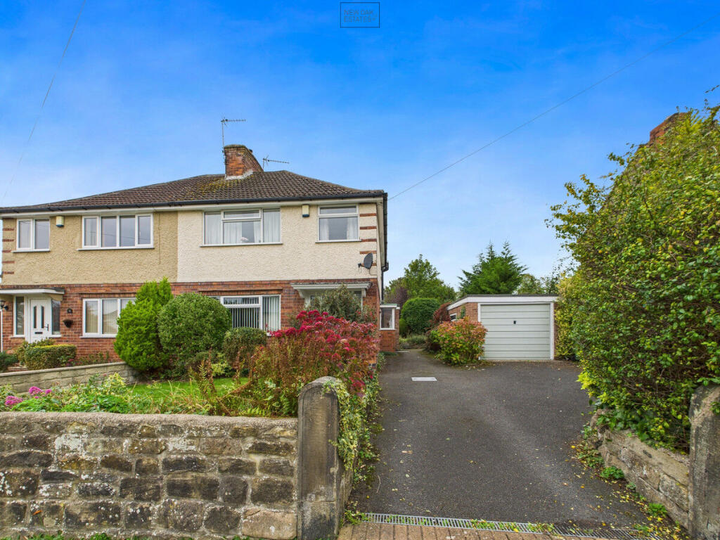
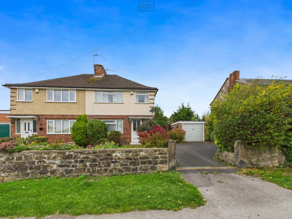
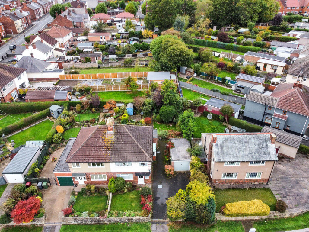
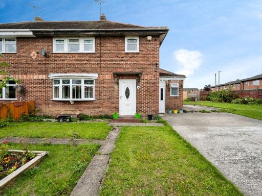
- semi-detached house mid-20th century
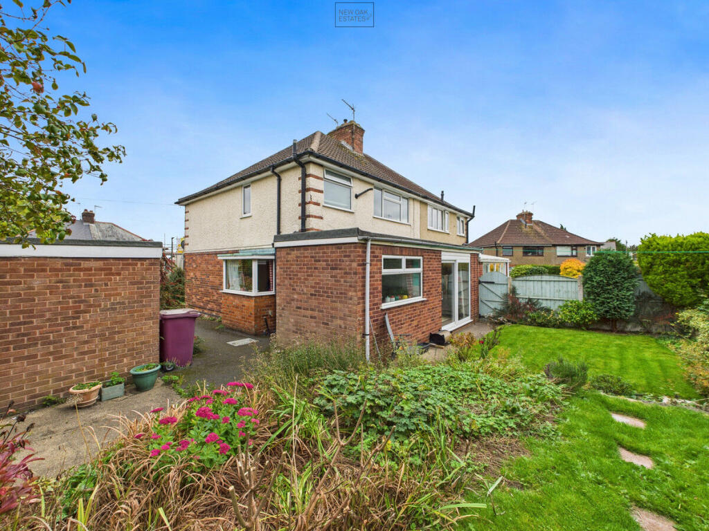
- semi-detached house mid 20th century
Floorplan Description
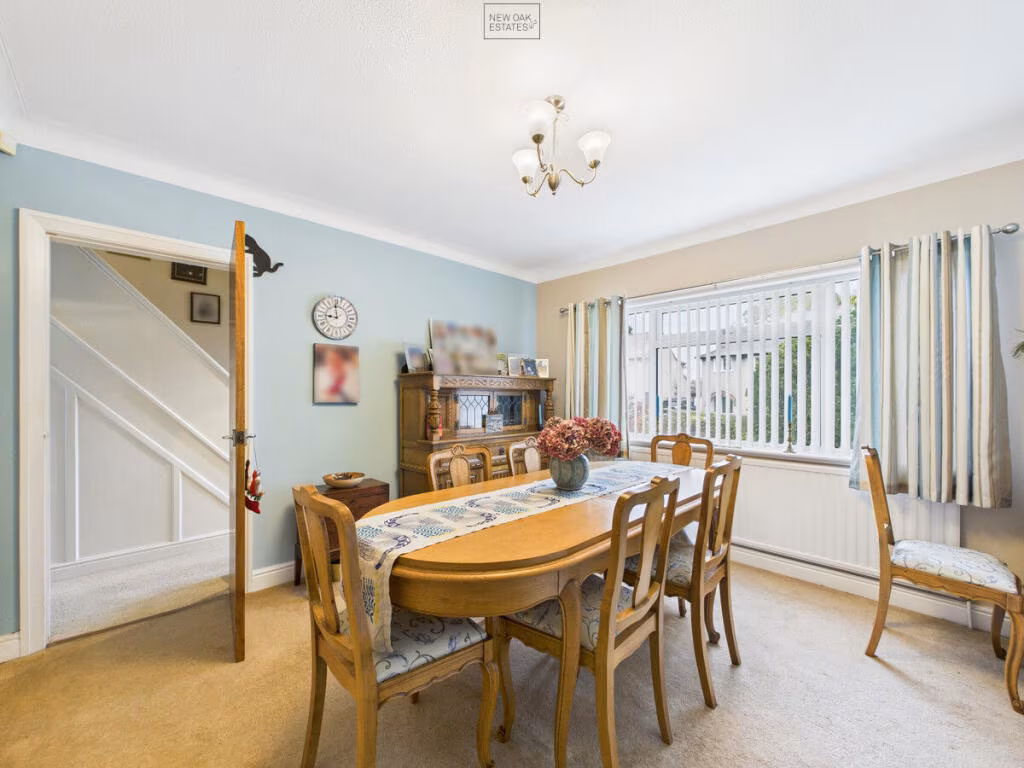
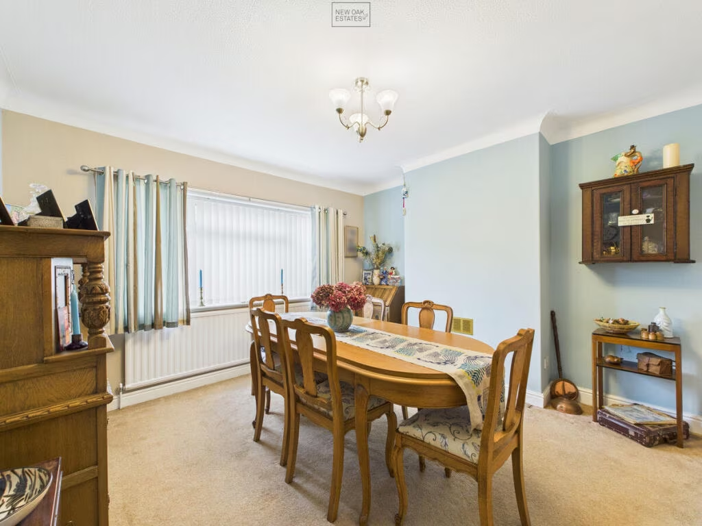
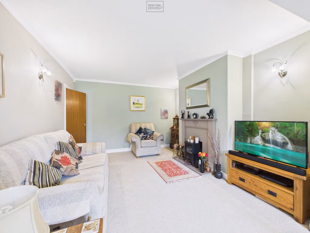
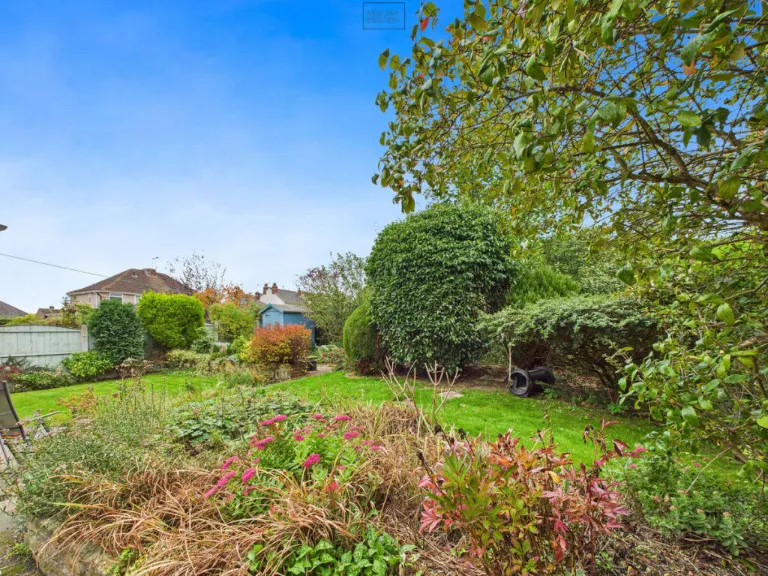
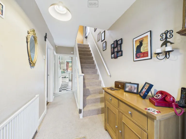
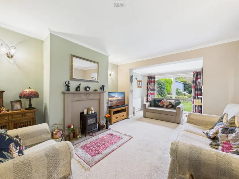
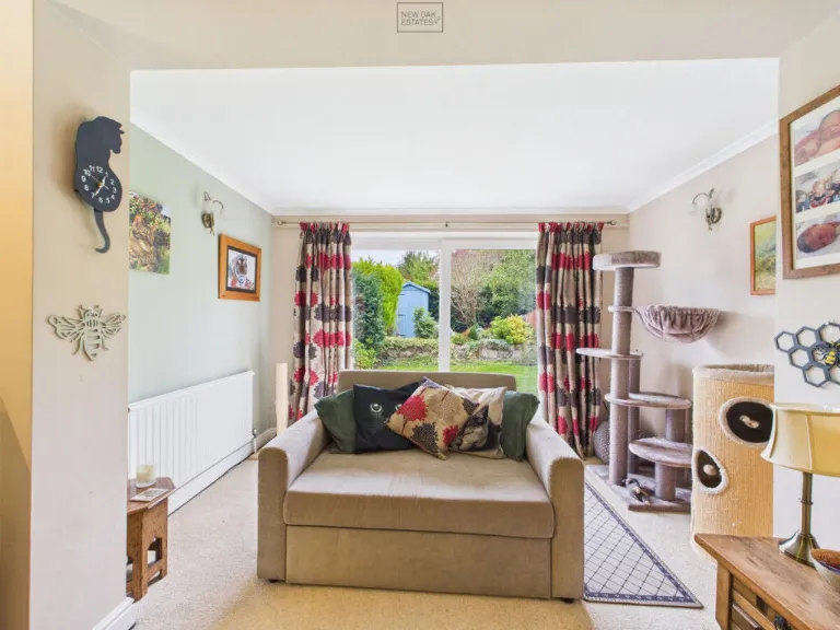
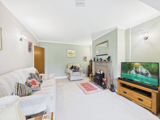
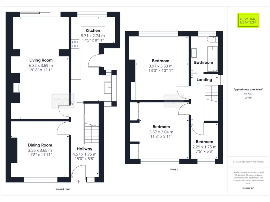
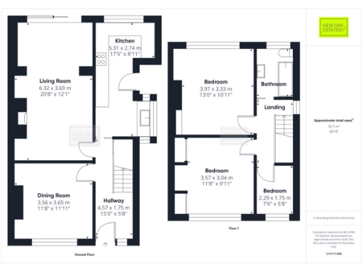
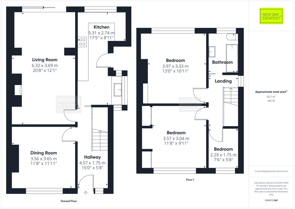
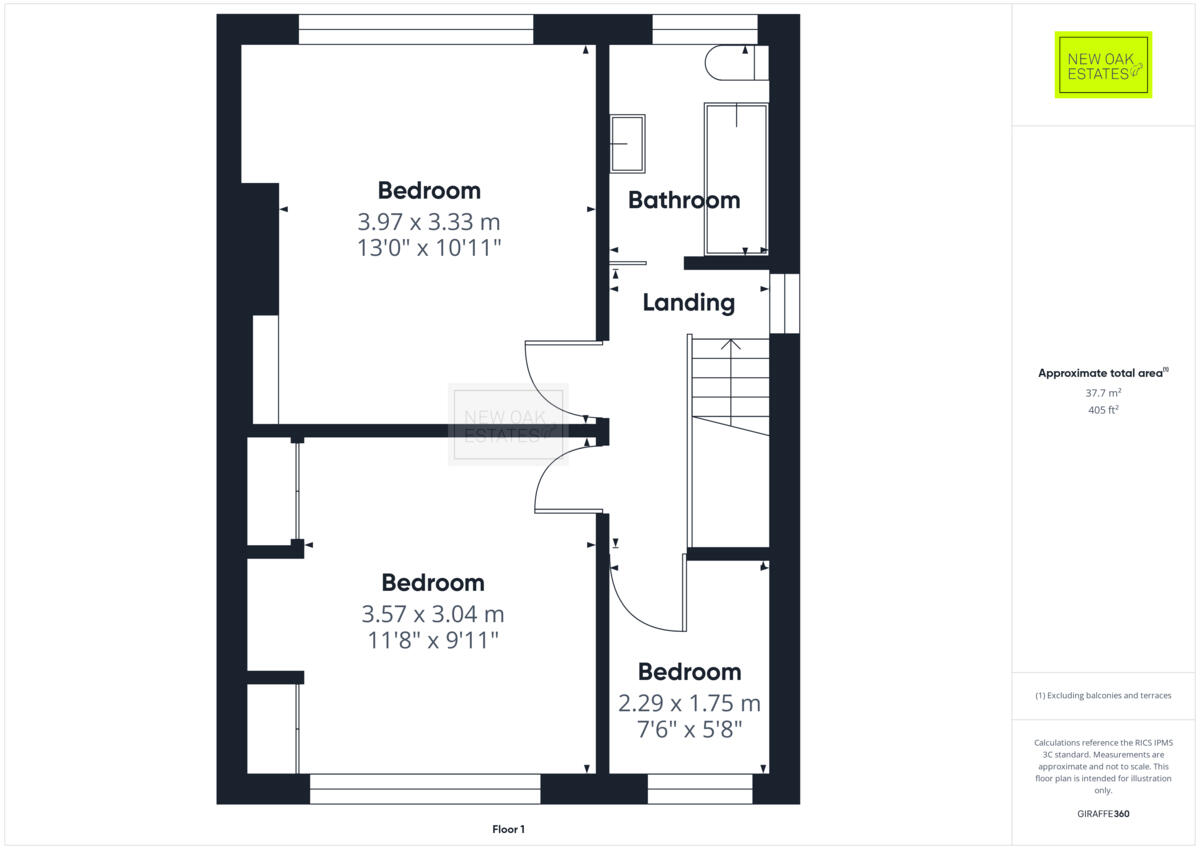
- Two-storey residential property with ground floor living, dining, kitchen and hallway; three bedrooms on first floor
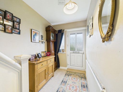
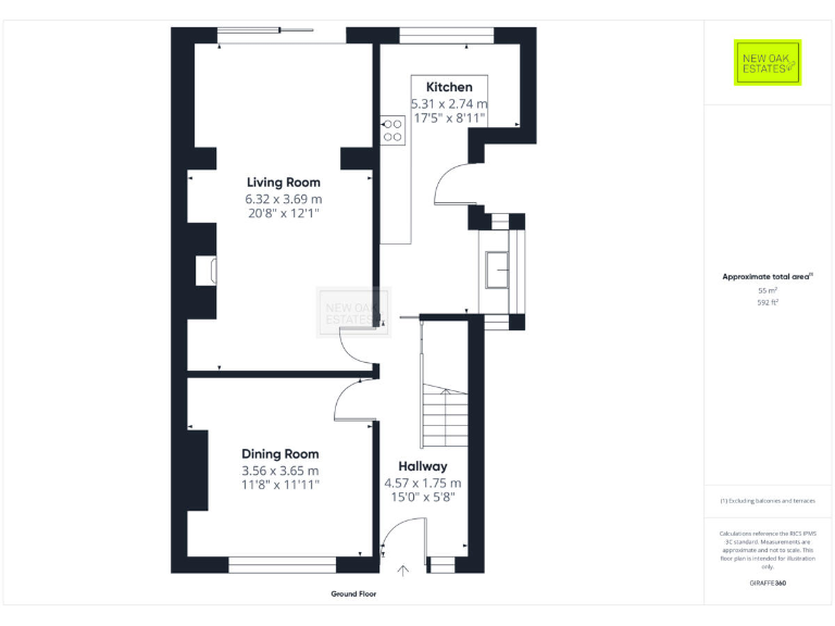
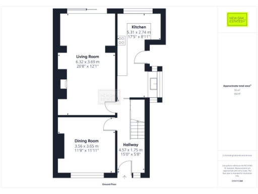
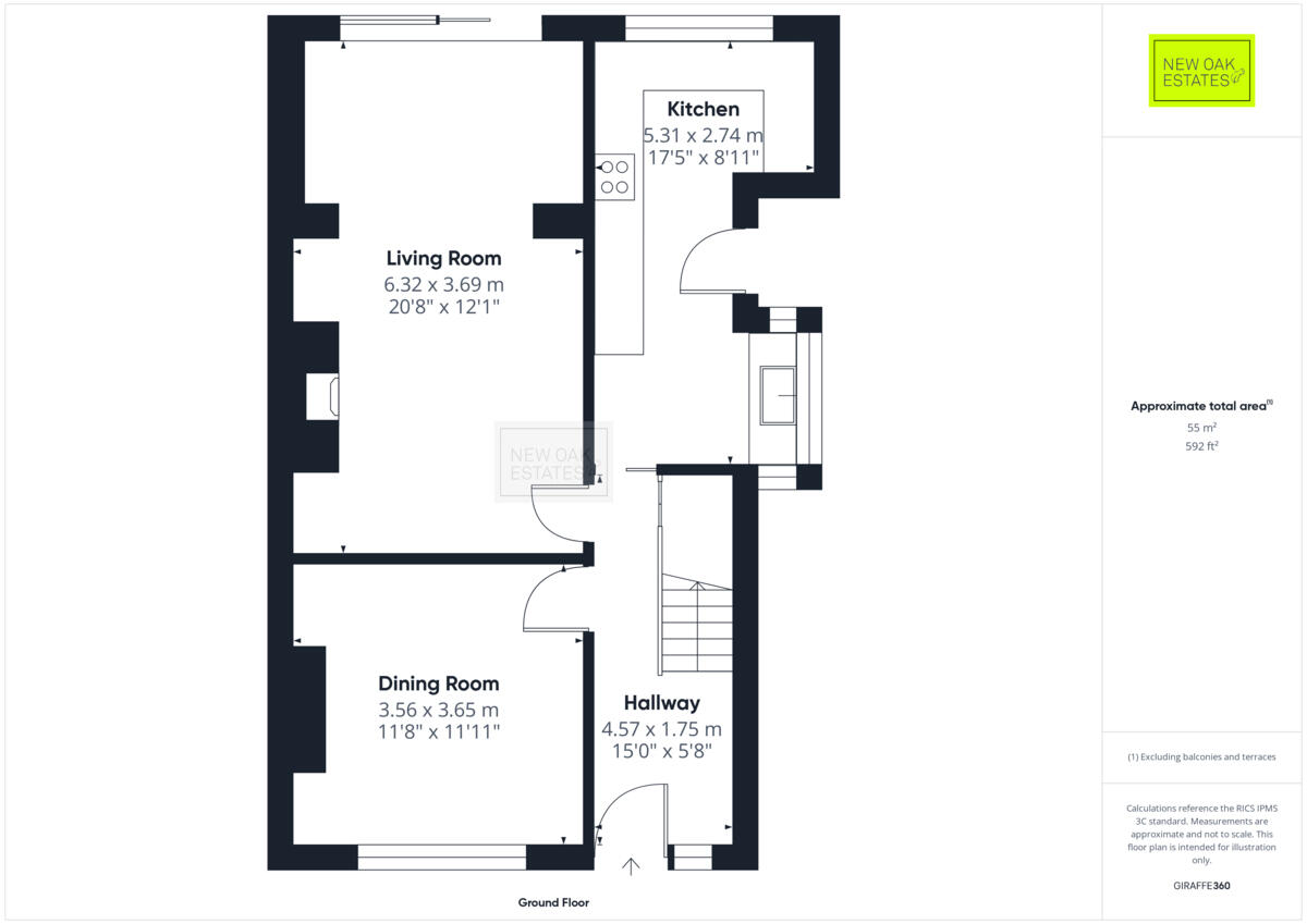
- Ground Floor layout with Living Room, Dining Room, Kitchen and Hallway
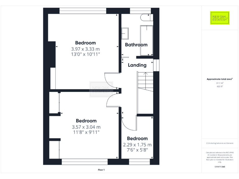
- First floor plan with three bedrooms and a bathroom
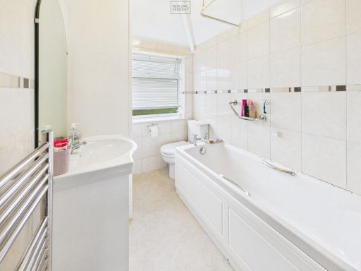
Rooms
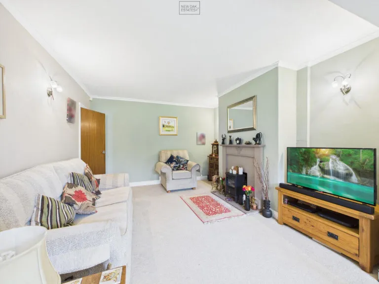
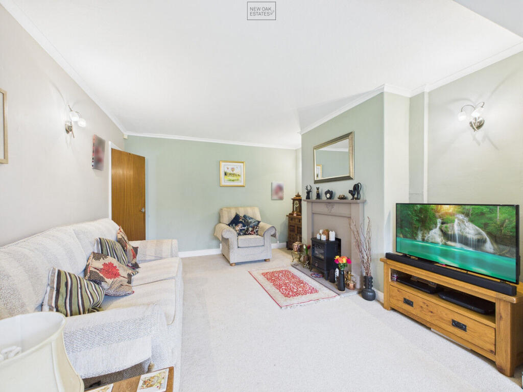
- Living Room:
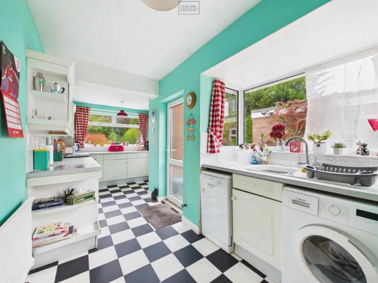
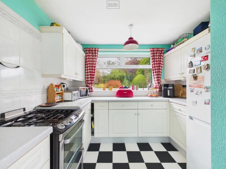
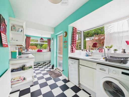
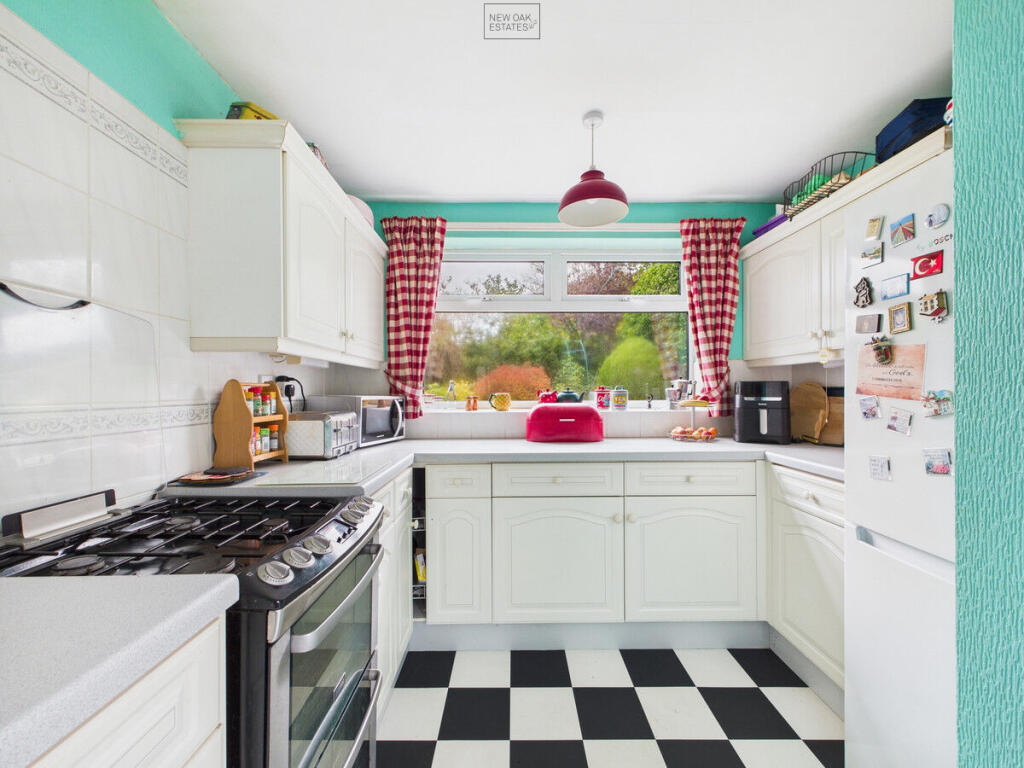
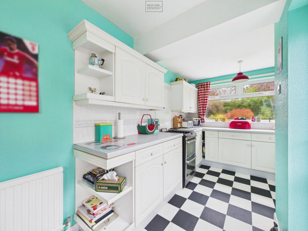
- Kitchen:
- Dining Room:
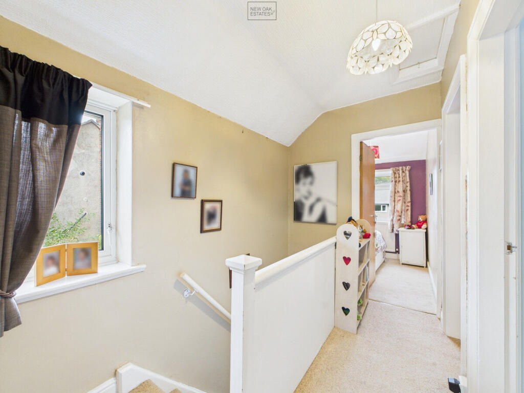
- Hallway:
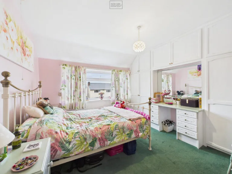
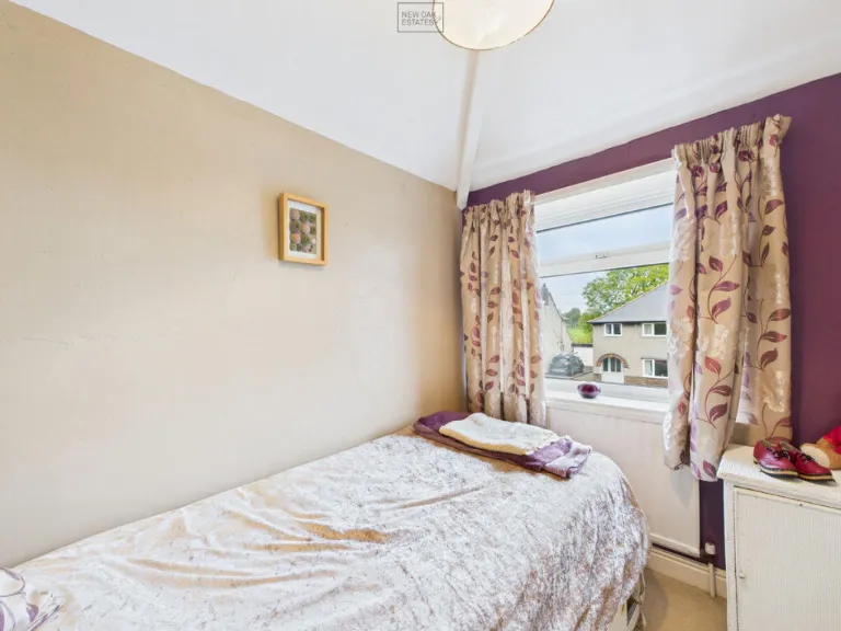
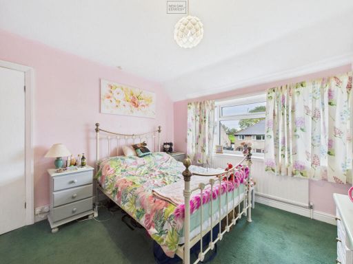
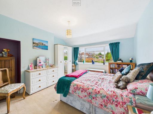
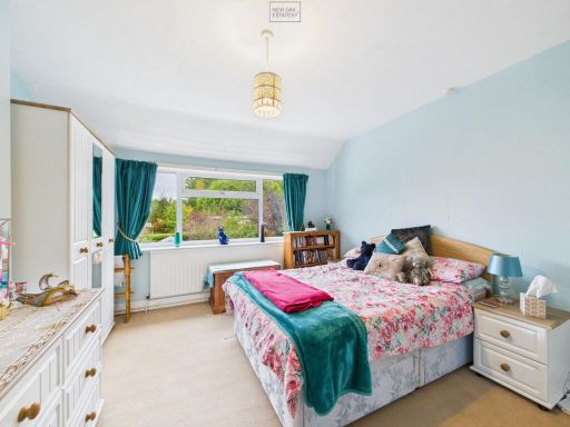
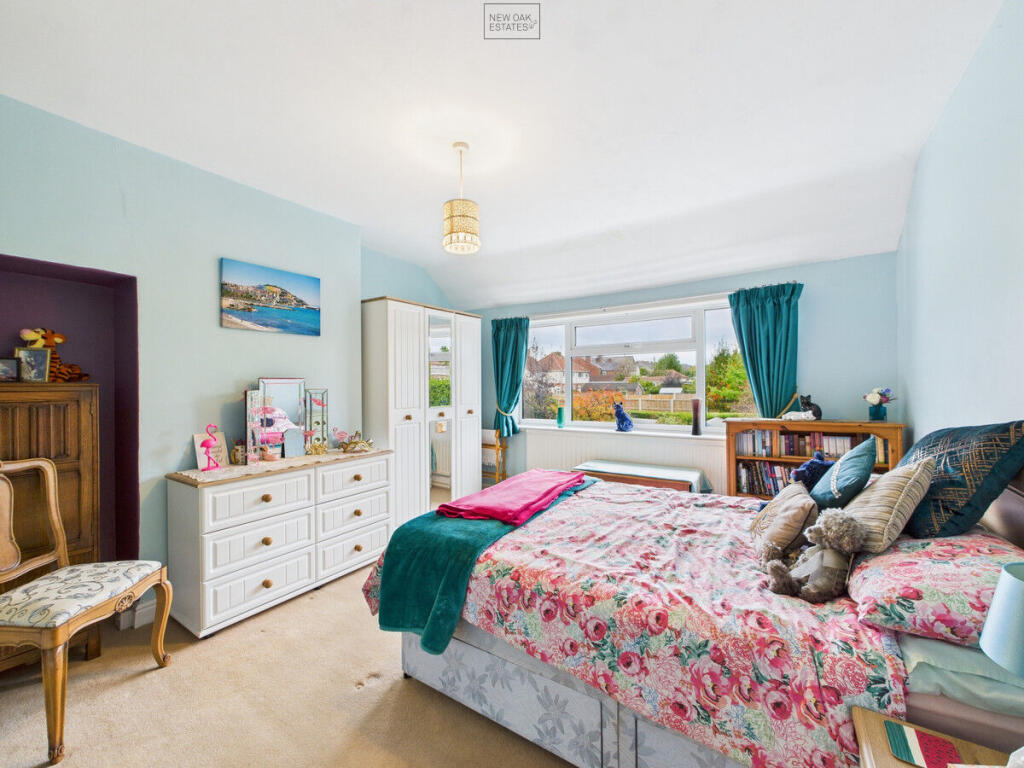
- Bedroom:
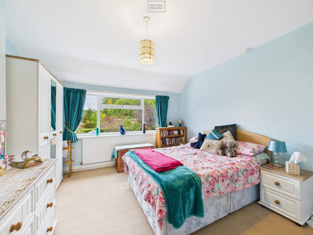
- Bedroom:
- Bedroom:
- Living Room:
- Kitchen:
- Dining Room:
- Hallway:
- Bedroom:
- Bedroom:
- Bedroom:
Textual Property Features
Detected Visual Features
- semi-detached
- mid-20th century
- 3-bedroom
- garage
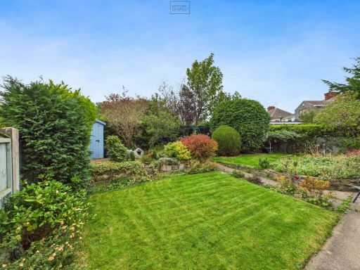
- front garden
- pebble dash
- brick
- asphalt driveway
- mid 20th century
- brick construction
- two-story
- driveway
- garden
- family home
EPC Details
- Fully double glazed
- Cavity wall, filled cavity
- Boiler and radiators, mains gas
- Low energy lighting in 40% of fixed outlets
- Suspended, no insulation (assumed)
Nearby Schools
- Copthorne Community Infant School
- Mickley Village Primary & Nursery School
- Morton Primary Academy
- Pilsley Primary School
- Hunloke Park Primary School
- Spire Junior School
- Wessington Primary School
- Westhouses Primary School
- Park House Primary School
- Holmgate Primary School and Nursery
- Spire Nursery and Infant School
- Christ the King Catholic Voluntary Academy
- Stonebroom Primary and Nursery School
- Town End Junior School
- Tibshelf Community School
- Sharley Park Community Primary School
- Tupton Hall School
- North Wingfield Primary and Nursery Academy
- Tupton Primary and Nursery Academy
- Deer Park Primary School
- Walton Peak Flying High Academy
- Stretton Handley Church of England Primary School
- Grassmoor Primary School
- Temple Normanton Junior Academy
- Hasland Junior School
- Outwood Academy Hasland Hall
- Hasland Infant School
Nearest Bars And Restaurants
- Id: 247768497
- Tags:
- Addr:
- Amenity: pub
- Building: yes
- Floor:
- Food: yes
- Former_name: The 3 Bar
- Name: The Three Horseshoes
- Outdoor_seating: yes
- Real_ale: 3 beers, presumably varying
- Source: Bing
- TagsNormalized:
- Lat: 53.1666633
- Lon: -1.4121146
- FullGeoHash: gcqyryewr27h
- PartitionGeoHash: gcqy
- Images:
- FoodStandards: null
- Distance: 339.1
,- Id: 3418524459
- Tags:
- Amenity: fast_food
- Name: Leon's
- TagsNormalized:
- Lat: 53.1667222
- Lon: -1.4118059
- FullGeoHash: gcqyryeywe35
- PartitionGeoHash: gcqy
- Images:
- FoodStandards: null
- Distance: 328.3
,- Id: 3418524455
- Tags:
- Amenity: fast_food
- Cuisine: chinese
- Name: Huang Ying
- TagsNormalized:
- Lat: 53.1667302
- Lon: -1.4117389
- FullGeoHash: gcqyrysn8hg5
- PartitionGeoHash: gcqy
- Images:
- FoodStandards: null
- Distance: 325.7
,- Id: 3418524454
- Tags:
- Addr:
- Housenumber: 59
- Street: Market Street
- Amenity: fast_food
- Cuisine: indian
- Name: Jaishu's
- Source: Leaflet and Lamb Dopiaza
- TagsNormalized:
- Lat: 53.1667415
- Lon: -1.4116101
- FullGeoHash: gcqyrysnengn
- PartitionGeoHash: gcqy
- Images:
- FoodStandards: null
- Distance: 320.5
,- Id: 243556110
- Tags:
- Addr:
- Amenity: fast_food
- Building: yes
- Cuisine: chinese
- Name: The Fat Panda
- TagsNormalized:
- Lat: 53.163768
- Lon: -1.4127533
- FullGeoHash: gcqyry5m2kwv
- PartitionGeoHash: gcqy
- Images:
- FoodStandards: null
- Distance: 317.4
}
Nearest General Shops
- Id: 243556114
- Tags:
- Building: yes
- Name: Ghost Ink
- Shop: tattoo
- TagsNormalized:
- Lat: 53.1638273
- Lon: -1.412445
- FullGeoHash: gcqyry5mxxsw
- PartitionGeoHash: gcqy
- Images:
- FoodStandards: null
- Distance: 295.8
,- Id: 3722180101
- Tags:
- Name: Dogsbody
- Note: Dog and Cat grooming
- Shop: pet_grooming
- TagsNormalized:
- Lat: 53.1662422
- Lon: -1.4117699
- FullGeoHash: gcqyryegz3uh
- PartitionGeoHash: gcqy
- Images:
- FoodStandards: null
- Distance: 292
,- Id: 368374536
- Tags:
- Name: Peak Fireplaces
- Shop: fireplace
- TagsNormalized:
- Lat: 53.1663275
- Lon: -1.4115309
- FullGeoHash: gcqyryshkcy3
- PartitionGeoHash: gcqy
- Images:
- FoodStandards: null
- Distance: 285.3
}
Nearest Grocery shops
- Id: 251770784
- Tags:
- Alt_name: Fultons
- Brand: Fulton's Foods
- Brand:wikidata: Q6112633
- Brand:wikipedia: en:Fulton's Foods
- Building: retail
- Name: Fulton's Foods
- Shop: frozen_food
- TagsNormalized:
- retail
- frozen food
- food
- shop
- Lat: 53.168075
- Lon: -1.4130377
- FullGeoHash: gcqyrygn3zd9
- PartitionGeoHash: gcqy
- Images:
- FoodStandards: null
- Distance: 494.3
,- Id: 223961350
- Tags:
- Brand: Iceland
- Brand:wikidata: Q721810
- Brand:wikipedia: en:Iceland (supermarket)
- Building: yes
- Contact:
- Website: https://www.iceland.co.uk/store-finder/store?StoreID=1431&StoreName=CLAY%20CROSS
- Name: Iceland
- Shop: frozen_food
- Source: Bing
- Wheelchair: yes
- TagsNormalized:
- iceland
- frozen food
- food
- shop
- Lat: 53.1670039
- Lon: -1.4129791
- FullGeoHash: gcqyryg05py7
- PartitionGeoHash: gcqy
- Images:
- FoodStandards: null
- Distance: 407.7
,- Id: 243556122
- Tags:
- Brand: Nisa Local
- Brand:wikidata: Q16999069
- Brand:wikipedia: en:Nisa (retailer)
- Building: yes
- Name: Nisa Local
- Shop: convenience
- Source: View from north
- TagsNormalized:
- nisa
- nisa local
- convenience
- shop
- Lat: 53.1639981
- Lon: -1.4041333
- FullGeoHash: gcrn2n1w9rd3
- PartitionGeoHash: gcrn
- Images:
- FoodStandards: null
- Distance: 284.4
}
Nearest Supermarkets
- Id: 278437079
- Tags:
- Addr:
- City: Chesterfield
- Postcode: S41 0HL
- Street: Spital Lane
- Building: yes
- Name: Co-op
- Opening_hours: 07:00-23:00
- Operator: The Co-operative Group
- Shop: supermarket
- Wheelchair: yes
- TagsNormalized:
- Lat: 53.2293331
- Lon: -1.4161285
- FullGeoHash: gcqyzf0g3ffh
- PartitionGeoHash: gcqy
- Images:
- FoodStandards: null
- Distance: 7207.8
,- Id: 508491368
- Tags:
- Brand: ALDI
- Brand:wikidata: Q41171672
- Brand:wikipedia: en:Aldi
- Building: yes
- Contact:
- Website: https://stores.aldi.co.uk/clay-cross/8-high-street
- Name: Aldi
- Opening_hours: Mo-Sa 08:00-22:00; Su 10:00-16:00
- Shop: supermarket
- Source: View from west
- TagsNormalized:
- Lat: 53.1681587
- Lon: -1.4154848
- FullGeoHash: gcqyrycqbz4h
- PartitionGeoHash: gcqy
- Images:
- FoodStandards: null
- Distance: 618.3
,- Id: 97165999
- Tags:
- Brand: Tesco Extra
- Brand:wikidata: Q25172225
- Brand:wikipedia: en:Tesco Extra
- Building: yes
- Contact:
- Website: https://www.tesco.com/store-locator/chesterfield/bridge-st-north
- Name: Tesco Extra
- Opening_hours: Mo-Sa 06:00-24:00; Su 10:00-16:00
- Shop: supermarket
- Source: Bing;local_knowledge
- Wheelchair: yes
- TagsNormalized:
- tesco
- tesco extra
- supermarket
- shop
- Lat: 53.1689938
- Lon: -1.4096825
- FullGeoHash: gcqyrzjeb4bd
- PartitionGeoHash: gcqy
- Images:
- FoodStandards: null
- Distance: 488.7
}
Nearest Religious buildings
- Id: 224022272
- Tags:
- Amenity: place_of_worship
- Denomination: assemblies_of_god
- Name: C4 Church
- Official_name: Clay Cross Community Church
- Religion: christian
- Service_times: Su 10:30
- Source: survey
- TagsNormalized:
- place of worship
- church
- christian
- Lat: 53.1668429
- Lon: -1.4107022
- FullGeoHash: gcqyrysz23b5
- PartitionGeoHash: gcqy
- Images:
- FoodStandards: null
- Distance: 290.7
,- Id: 243556123
- Tags:
- Addr:
- City: Chesterfield
- Country: GB
- Housenumber: 42
- Postcode: S45 9JR
- Street: Thanet Street
- Town: Clay Cross
- Amenity: place_of_worship
- Building: yes
- Name: Salvation Army
- Religion: christian
- TagsNormalized:
- place of worship
- salvation army
- christian
- church
- Lat: 53.1639667
- Lon: -1.4122173
- FullGeoHash: gcqyry5wscwq
- PartitionGeoHash: gcqy
- Images:
- FoodStandards: null
- Distance: 276.7
,- Id: 243556113
- Tags:
- Amenity: place_of_worship
- Building: yes
- Denomination: roman_catholic
- Name: St Patrick and St Bridget
- Religion: christian
- TagsNormalized:
- place of worship
- catholic
- roman catholic
- christian
- church
- Lat: 53.1640669
- Lon: -1.4113287
- FullGeoHash: gcqyryhr1smh
- PartitionGeoHash: gcqy
- Images:
- FoodStandards: null
- Distance: 216.8
}
Nearest Medical buildings
- Id: 3723854994
- Tags:
- Amenity: pharmacy
- Healthcare: pharmacy
- Name: Peak Pharmacy
- TagsNormalized:
- Lat: 53.1682599
- Lon: -1.4125321
- FullGeoHash: gcqyrygrtd58
- PartitionGeoHash: gcqy
- Images:
- FoodStandards: null
- Distance: 489.7
,- Id: 3723854993
- Tags:
- Amenity: doctors
- Healthcare: doctor
- Name: Clay Cross Medical Centre
- TagsNormalized:
- doctor
- doctors
- health
- healthcare
- Lat: 53.1680631
- Lon: -1.4121749
- FullGeoHash: gcqyrygwmvq4
- PartitionGeoHash: gcqy
- Images:
- FoodStandards: null
- Distance: 458.1
,- Id: 263728199
- Tags:
- Amenity: hospital
- Healthcare: hospital
- Name: Clay Cross Hospital
- TagsNormalized:
- Lat: 53.1672706
- Lon: -1.4065197
- FullGeoHash: gcqyryzcc9wf
- PartitionGeoHash: gcqy
- Images:
- FoodStandards: null
- Distance: 309.7
,- Id: 247768223
- Tags:
- Amenity: dentist
- Building: yes
- Healthcare: dentist
- Name: Clay Cross Dental
- Source: Bing
- TagsNormalized:
- dentist
- health
- healthcare
- dental
- Lat: 53.1669629
- Lon: -1.410519
- FullGeoHash: gcqyryubh80z
- PartitionGeoHash: gcqy
- Images:
- FoodStandards: null
- Distance: 295.3
}
Nearest Leisure Facilities
- Id: 191478147
- Tags:
- Building: yes
- Leisure: sports_centre
- Name: Sharley Park Leisure Centre
- Source: Bing;local_knowledge
- TagsNormalized:
- sports
- sports centre
- leisure
- Lat: 53.1685065
- Lon: -1.4060505
- FullGeoHash: gcrn2p00uxuz
- PartitionGeoHash: gcrn
- Images:
- FoodStandards: null
- Distance: 449.5
,- Id: 247768215
- Tags:
- Leisure: pitch
- Sport: cricket
- TagsNormalized:
- pitch
- leisure
- cricket
- sports
- Lat: 53.1664639
- Lon: -1.4028759
- FullGeoHash: gcrn2ndmne5y
- PartitionGeoHash: gcrn
- Images:
- FoodStandards: null
- Distance: 408.9
,- Id: 231745419
- Tags:
- Leisure: park
- Source: View from N;Bing
- TagsNormalized:
- Lat: 53.162629
- Lon: -1.4031662
- FullGeoHash: gcrn2jfnzb76
- PartitionGeoHash: gcrn
- Images:
- FoodStandards: null
- Distance: 408.4
,- Id: 247759553
- Tags:
- TagsNormalized:
- Lat: 53.166674
- Lon: -1.4036652
- FullGeoHash: gcrn2n9yk4r7
- PartitionGeoHash: gcrn
- Images:
- FoodStandards: null
- Distance: 377
,- Id: 904157157
- Tags:
- Leisure: pitch
- Sport: soccer
- TagsNormalized:
- Lat: 53.166097
- Lon: -1.4068508
- FullGeoHash: gcqyryxdfnb4
- PartitionGeoHash: gcqy
- Images:
- FoodStandards: null
- Distance: 182.5
}
Nearest Tourist attractions
- Id: 78820682
- Tags:
- Name: Millfield Mobile Home Park
- Source: OS OpenData StreetView
- Tourism: caravan_site
- TagsNormalized:
- Lat: 53.173863
- Lon: -1.436202
- FullGeoHash: gcqyx240nnd0
- PartitionGeoHash: gcqy
- Images:
- FoodStandards: null
- Distance: 2124.8
,- Id: 1674577497
- Tags:
- Name: 10 Acres Farm
- Tourism: camp_site
- TagsNormalized:
- Lat: 53.1590575
- Lon: -1.3778935
- FullGeoHash: gcrn2tk9uy81
- PartitionGeoHash: gcrn
- Images:
- FoodStandards: null
- Distance: 2117.9
,- Id: 397705584
- Tags:
- Guest_house: bed_and_breakfast
- Name: South View
- Tourism: guest_house
- TagsNormalized:
- Lat: 53.1732765
- Lon: -1.3889372
- FullGeoHash: gcrn2rusg3jm
- PartitionGeoHash: gcrn
- Images:
- FoodStandards: null
- Distance: 1602.8
}
Nearest Train stations
- Id: 6415346594
- Tags:
- Name: Matlock Bath
- Naptan:
- Network: National Rail
- Public_transport: station
- Railway: station
- Ref:
- Source: NPE
- Wikidata: Q2537583
- Wikipedia: en:Matlock Bath railway station
- TagsNormalized:
- Lat: 53.1225529
- Lon: -1.5568716
- FullGeoHash: gcqyhwdm6387
- PartitionGeoHash: gcqy
- Images:
- FoodStandards: null
- Distance: 10964.1
,- Id: 5177806338
- Tags:
- Name: Matlock Riverside
- Public_transport: station
- Railway: station
- Usage: tourism
- Wikidata: Q6787688
- Wikipedia: en:Matlock Riverside railway station
- TagsNormalized:
- Lat: 53.1411575
- Lon: -1.5668186
- FullGeoHash: gcqyk651dmz2
- PartitionGeoHash: gcqy
- Images:
- FoodStandards: null
- Distance: 10892.8
,- Id: 6415346593
- Tags:
- Name: Matlock
- Naptan:
- Network: National Rail
- Operator: East Midlands Railway
- Public_transport: station
- Railway: station
- Ref:
- Toilets:
- Train: yes
- Wheelchair: yes
- Wikidata: Q4591297
- Wikipedia: en:Matlock railway station
- TagsNormalized:
- Lat: 53.1381136
- Lon: -1.5585511
- FullGeoHash: gcqyk93pgnk4
- PartitionGeoHash: gcqy
- Images:
- FoodStandards: null
- Distance: 10449.5
,- Id: 7154300845
- Tags:
- Name: Chesterfield
- Naptan:
- Network: National Rail
- Public_transport: station
- Railway: station
- Ref:
- Wikidata: Q2645921
- Wikipedia: en:Chesterfield railway station
- TagsNormalized:
- Lat: 53.2382236
- Lon: -1.4197283
- FullGeoHash: gcqyzewpjujv
- PartitionGeoHash: gcqy
- Images:
- FoodStandards: null
- Distance: 8212.9
,- Id: 7147304696
- Tags:
- Name: Alfreton
- Naptan:
- Network: National Rail
- Public_transport: station
- Railway: station
- Ref:
- Train: yes
- Wikidata: Q1872948
- Wikipedia: en:Alfreton railway station
- TagsNormalized:
- Lat: 53.1010582
- Lon: -1.3698401
- FullGeoHash: gcrn0ff806tn
- PartitionGeoHash: gcrn
- Images:
- FoodStandards: null
- Distance: 7524.5
}
Nearest Bus stations and stops
- Id: 318758467
- Tags:
- Bus: yes
- Highway: bus_stop
- Public_transport: platform
- TagsNormalized:
- Lat: 53.1641015
- Lon: -1.4041441
- FullGeoHash: gcrn2n1x34f6
- PartitionGeoHash: gcrn
- Images:
- FoodStandards: null
- Distance: 280.9
,- Id: 318756692
- Tags:
- Bus: yes
- Highway: bus_stop
- Public_transport: platform
- TagsNormalized:
- Lat: 53.1637207
- Lon: -1.4120234
- FullGeoHash: gcqyry5v17z4
- PartitionGeoHash: gcqy
- Images:
- FoodStandards: null
- Distance: 273.8
,- Id: 318756905
- Tags:
- Bus: yes
- Highway: bus_stop
- Public_transport: platform
- TagsNormalized:
- Lat: 53.1638705
- Lon: -1.4116614
- FullGeoHash: gcqyryhjczub
- PartitionGeoHash: gcqy
- Images:
- FoodStandards: null
- Distance: 245.2
,- Id: 318757834
- Tags:
- Bus: yes
- Highway: bus_stop
- Public_transport: platform
- TagsNormalized:
- Lat: 53.1641443
- Lon: -1.4079598
- FullGeoHash: gcqyrynz84v1
- PartitionGeoHash: gcqy
- Images:
- FoodStandards: null
- Distance: 62.9
,- Id: 318758022
- Tags:
- Bus: yes
- Highway: bus_stop
- Public_transport: platform
- TagsNormalized:
- Lat: 53.1642147
- Lon: -1.4083928
- FullGeoHash: gcqyrynrypfj
- PartitionGeoHash: gcqy
- Images:
- FoodStandards: null
- Distance: 53.1
}
Nearest Hotels
- Id: 736979121
- Tags:
- Amenity: pub
- Name: Amber Hotel
- Note: Theatre organ in back room
- Outdoor_seating: yes
- Parking: yes
- Real_ale: Shepherd Neame Spitfire, Abbeydale Absolution
- TagsNormalized:
- Lat: 53.1085816
- Lon: -1.4195616
- FullGeoHash: gcqypsn7cv4j
- PartitionGeoHash: gcqy
- Images:
- FoodStandards: null
- Distance: 6283.8
,- Id: 145343569
- Tags:
- Addr:
- City: Alfreton
- Postcode: DE55 5TX
- Street: Newtonwood Lane
- Brand: Days Inn
- Brand:wikidata: Q1047239
- Brand:wikipedia: en:Days Inn
- Building: yes
- Name: Days Inn
- Source: Bing
- Tourism: hotel
- TagsNormalized:
- Lat: 53.1356061
- Lon: -1.3330634
- FullGeoHash: gcrn39j336gu
- PartitionGeoHash: gcrn
- Images:
- FoodStandards: null
- Distance: 5965.7
,- Id: 377762808
- Tags:
- Name: Santo's Higham Farm Hotel
- Tourism: hotel
- TagsNormalized:
- Lat: 53.125898
- Lon: -1.4191376
- FullGeoHash: gcqypxq8g9nm
- PartitionGeoHash: gcqy
- Images:
- FoodStandards: null
- Distance: 4373.6
}
Tags
- semi-detached
- mid-20th century
- 3-bedroom
- garage
- front garden
- pebble dash
- brick
- asphalt driveway
- semi-detached
- mid 20th century
- brick construction
- two-story
- garage
- driveway
- garden
- family home
Local Market Stats
- Average Price/sqft: £207
- Avg Income: £35600
- Rental Yield: 3.4%
- Social Housing: 8%
- Planning Success Rate: 57%
Similar Properties
 3 bedroom semi-detached house for sale in North Street, Clay Cross, Chesterfield, S45 — £180,000 • 3 bed • 1 bath • 948 ft²
 3 bedroom semi-detached house for sale in Nethercroft Lane, Danesmoor, S45 — £190,000 • 3 bed • 1 bath • 951 ft²
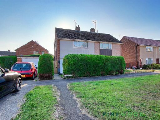 2 bedroom semi-detached house for sale in Rye Crescent, Danesmoor, Chesterfield, Derbyshire S45 — £135,000 • 2 bed • 1 bath • 883 ft²
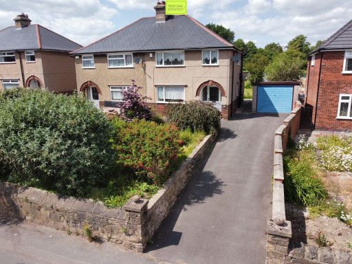 3 bedroom semi-detached house for sale in Thanet Street, Clay Cross, S45 — £199,950 • 3 bed • 1 bath • 913 ft²
 2 bedroom end of terrace house for sale in Market Street, Clay Cross, Chesterfield, Derbyshire, S45 — £110,000 • 2 bed • 1 bath • 1120 ft²
 3 bedroom terraced house for sale in Florence Road, Clay Cross, S45 — £170,000 • 3 bed • 1 bath • 850 ft²
Meta
- {
"@context": "https://schema.org",
"@type": "Residence",
"name": "3 bedroom semidetached house for sale in Bertrand Avenue, C…",
"description": "",
"url": "https://propertypiper.co.uk/property/e0866888-53e7-4ca6-b567-df6c07c0508f",
"image": "https://image-a.propertypiper.co.uk/faeb29ec-ba7c-4ccb-a9cd-62395c1c60bf-1024.jpeg",
"address": {
"@type": "PostalAddress",
"streetAddress": "23 BERTRAND AVENUE CLAY CROSS CHESTERFIELD",
"postalCode": "S45 9JX",
"addressLocality": "North East Derbyshire",
"addressRegion": "North East Derbyshire",
"addressCountry": "England"
},
"geo": {
"@type": "GeoCoordinates",
"latitude": 53.16468417448822,
"longitude": -1.408243551072799
},
"numberOfRooms": 3,
"numberOfBathroomsTotal": 1,
"floorSize": {
"@type": "QuantitativeValue",
"value": 997,
"unitCode": "FTK"
},
"offers": {
"@type": "Offer",
"price": 200000,
"priceCurrency": "GBP",
"availability": "https://schema.org/InStock"
},
"additionalProperty": [
{
"@type": "PropertyValue",
"name": "Feature",
"value": "semi-detached"
},
{
"@type": "PropertyValue",
"name": "Feature",
"value": "mid-20th century"
},
{
"@type": "PropertyValue",
"name": "Feature",
"value": "3-bedroom"
},
{
"@type": "PropertyValue",
"name": "Feature",
"value": "garage"
},
{
"@type": "PropertyValue",
"name": "Feature",
"value": "front garden"
},
{
"@type": "PropertyValue",
"name": "Feature",
"value": "pebble dash"
},
{
"@type": "PropertyValue",
"name": "Feature",
"value": "brick"
},
{
"@type": "PropertyValue",
"name": "Feature",
"value": "asphalt driveway"
},
{
"@type": "PropertyValue",
"name": "Feature",
"value": "semi-detached"
},
{
"@type": "PropertyValue",
"name": "Feature",
"value": "mid 20th century"
},
{
"@type": "PropertyValue",
"name": "Feature",
"value": "brick construction"
},
{
"@type": "PropertyValue",
"name": "Feature",
"value": "two-story"
},
{
"@type": "PropertyValue",
"name": "Feature",
"value": "garage"
},
{
"@type": "PropertyValue",
"name": "Feature",
"value": "driveway"
},
{
"@type": "PropertyValue",
"name": "Feature",
"value": "garden"
},
{
"@type": "PropertyValue",
"name": "Feature",
"value": "family home"
}
]
}
High Res Floorplan Images
Compatible Floorplan Images
FloorplanImages Thumbnail