BN27 4EW - 2 bedroom coach house for sale in New Road, Hellingly, Hail…
View on Property Piper
2 bedroom coach house for sale in New Road,
Hellingly,
Hailsham,
BN27 4EW, BN27
Property Details
- Price: £75000
- Bedrooms: 2
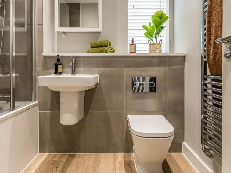
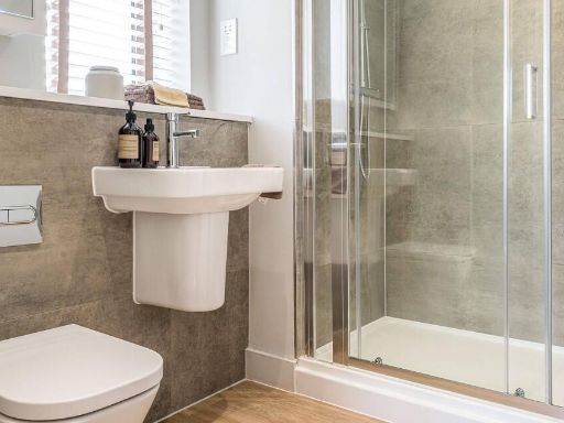
- Bathrooms: 2
- Property Type: undefined
- Property SubType: undefined
Brochure Descriptions
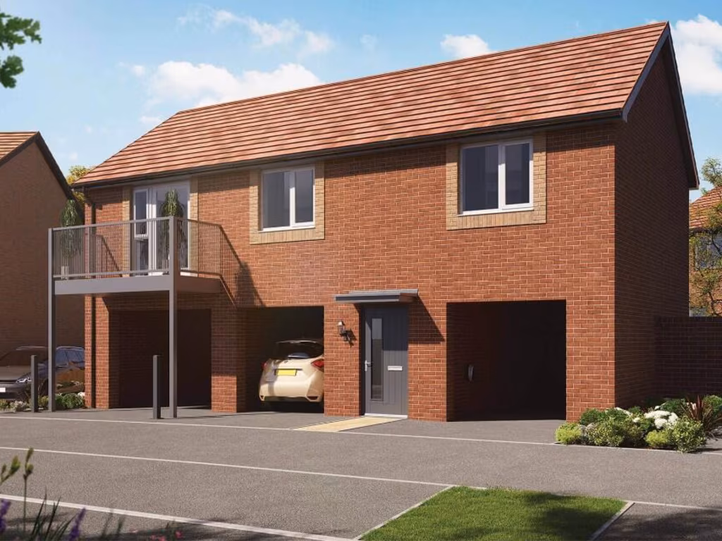
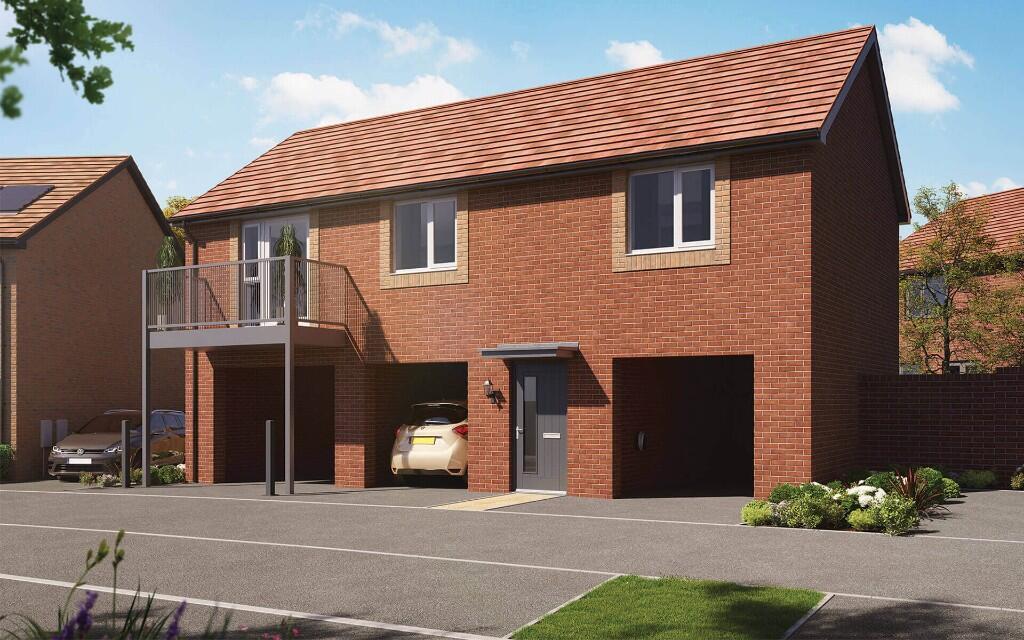
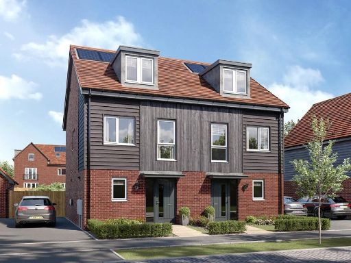
- Promotional image for a new‑build residential development (Orbit Homes at Swingate Park). Image suggests modern family housing within a park/green development. The visual shows a young couple in a minimally furnished interior with moving boxes and a potted plant, implying new occupation or turnover rather than a furnished show home. No specific room layout is visible; based on the marketing style this would typically be average-sized family homes (small–medium individual dwellings) set within communal green/open space. No furniture, fixtures or precise internal dimensions can be determined from the image.
- Residential development plot/site located at Swingate Park on New Road, Hellingly (near Hailsham) in East Sussex. The brochure page presents the development name and location with local and wider area maps showing a semi-rural setting with nearby villages, minor roads and open countryside — likely offering countryside views rather than urban or seafront panoramas. The site appears to be part of a planned housing estate (medium/large development scale inferred from the marketing map). Internal room and garden sizes are not shown on this page and cannot be determined from the image; the plot/estate itself is best described as a suburban/semi-rural residential development site with good local road connections to Hailsham and surrounding settlements.
- Promotional material for a residential development called 'Orbit Homes at Swingate Park'. The imagery and graphics indicate a family‑oriented housing development set adjacent to or within mature parkland/woodland. Expect homes positioned to take advantage of green, tree‑lined surroundings and walking routes; likely aimed at families given the family imagery. From the image alone there are no internal details — the scheme appears as a medium‑to‑large development with emphasis on outdoor amenity (parkland views). Garden sizes appear likely to be average to large for suburban plots; overall development size cannot be determined precisely from this cover image.
Image Descriptions
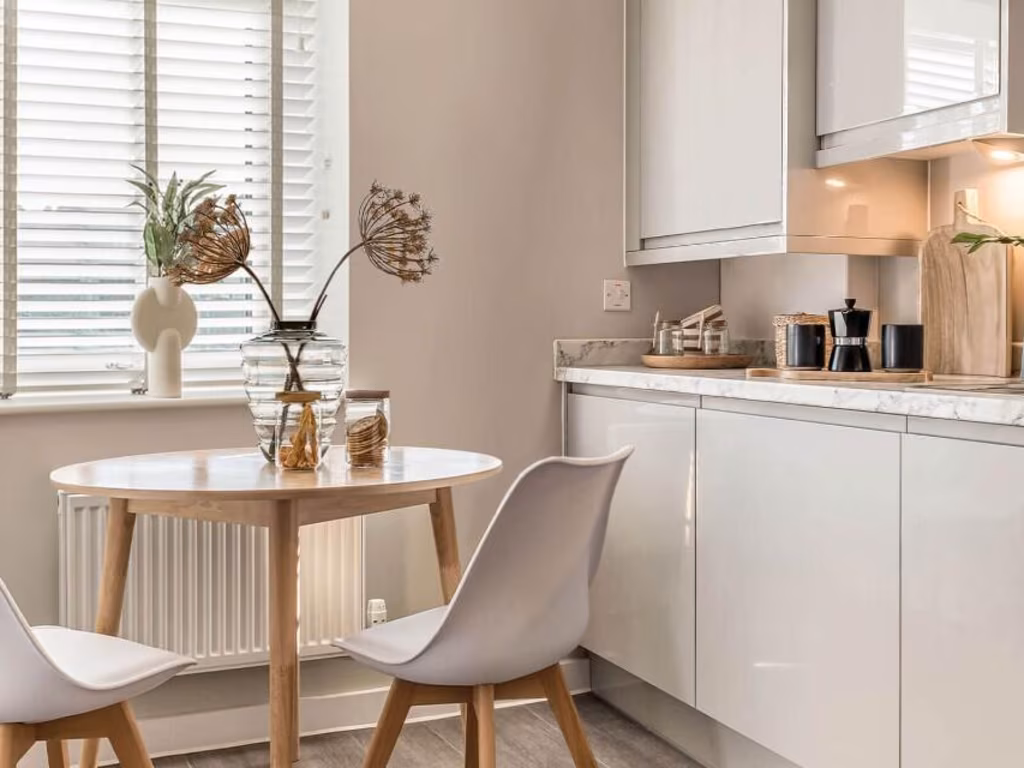
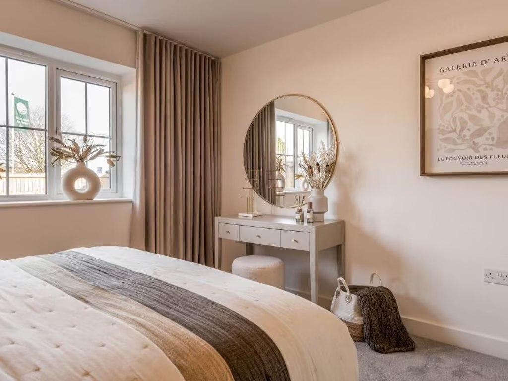
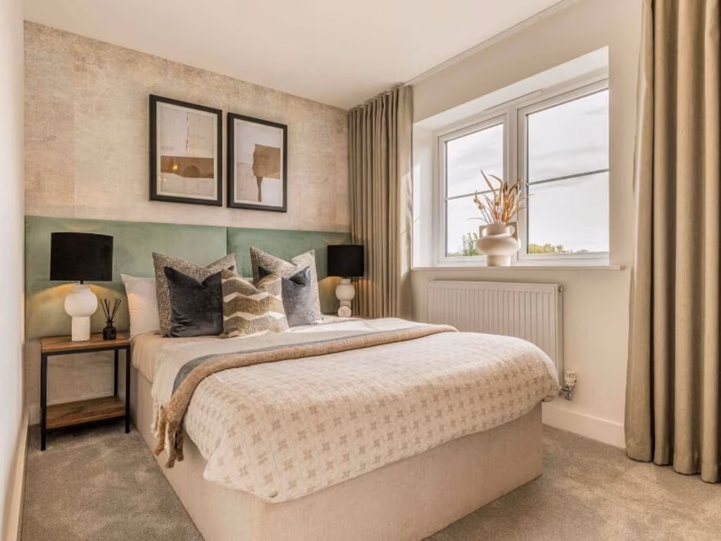
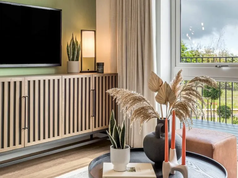
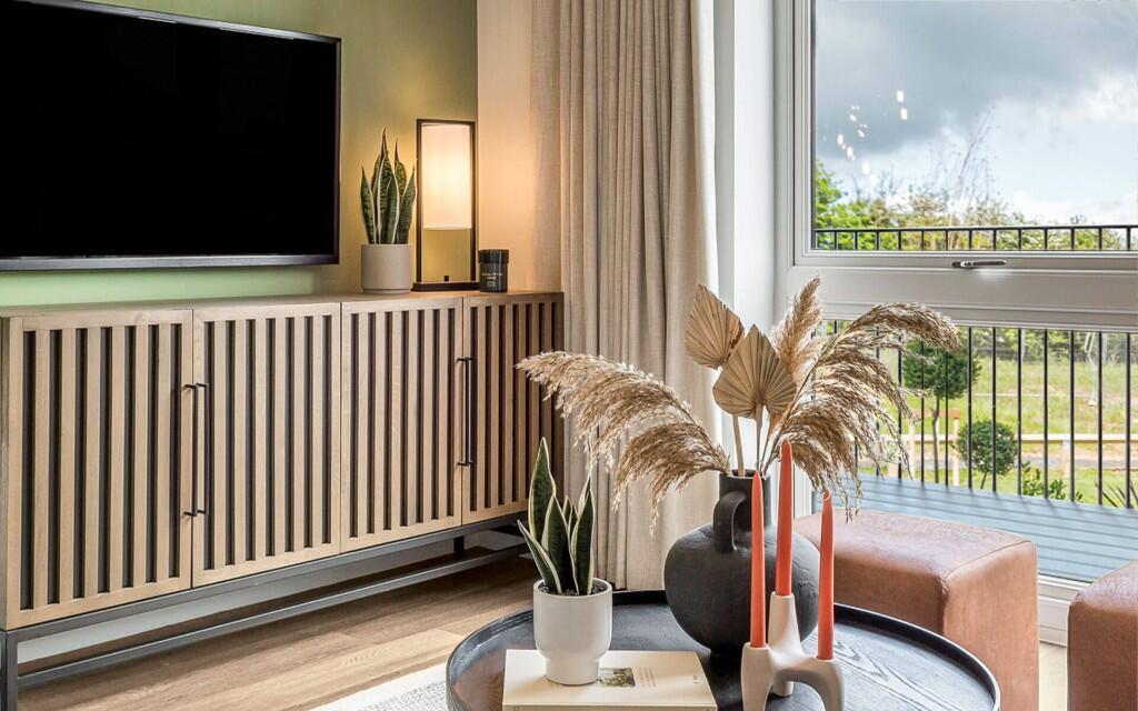
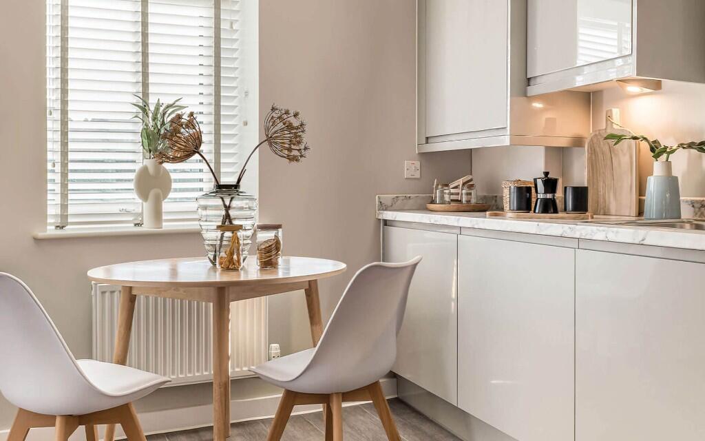
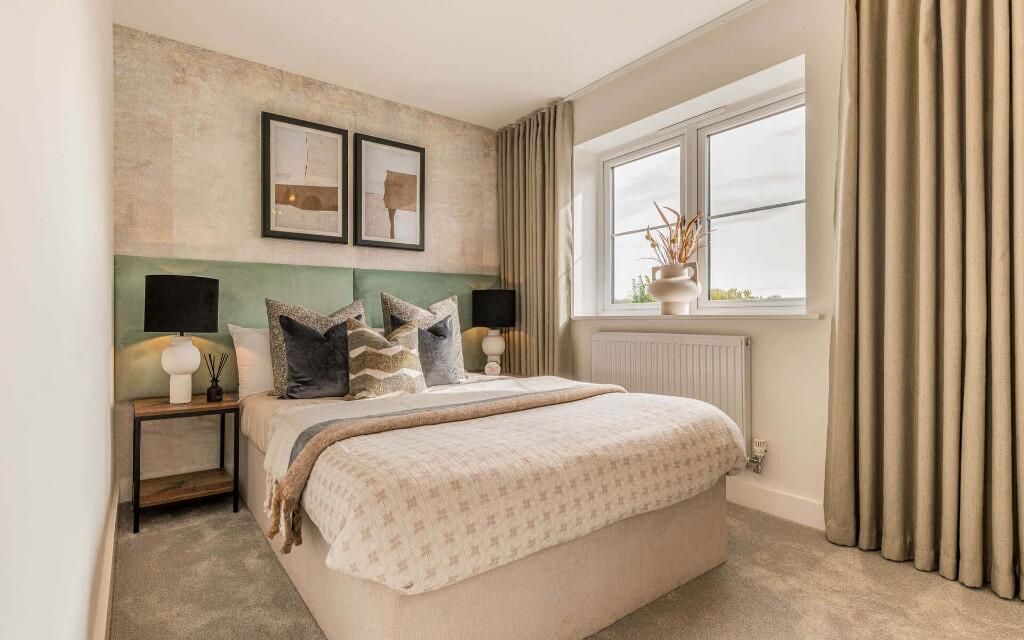
- living room contemporary
- living room contemporary
Floorplan Description
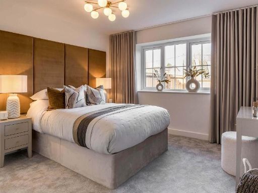
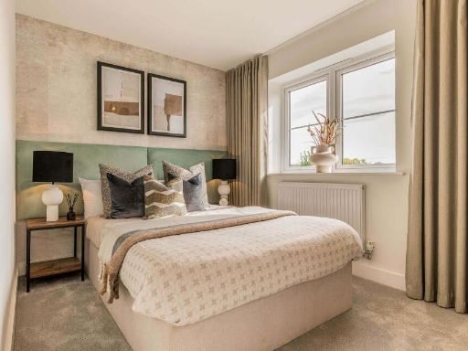
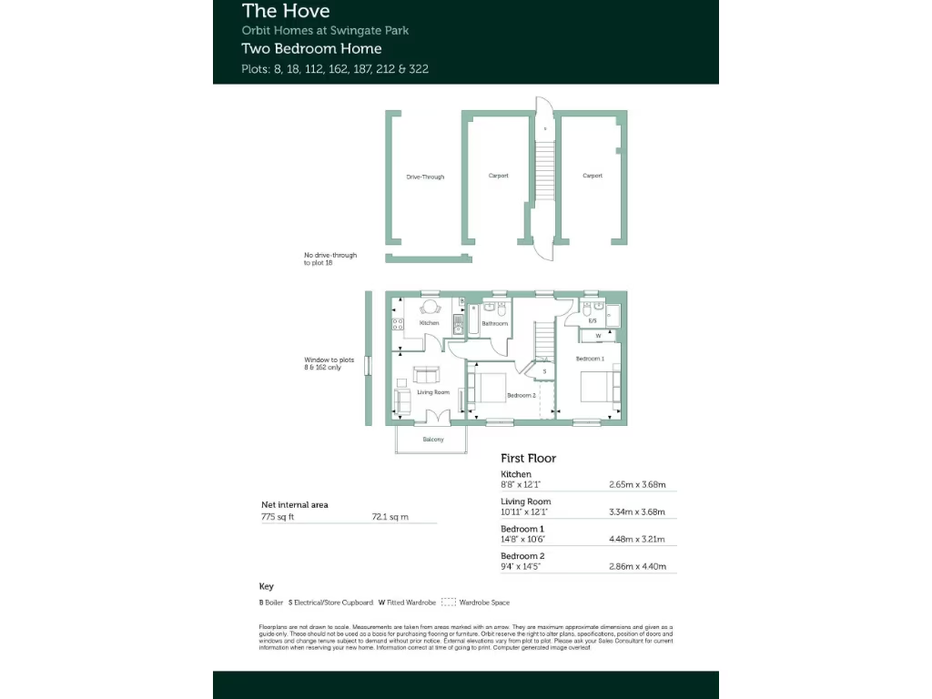
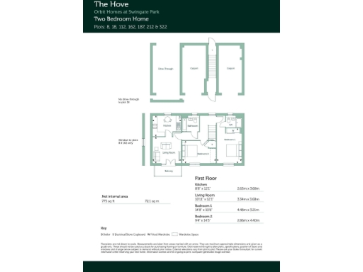
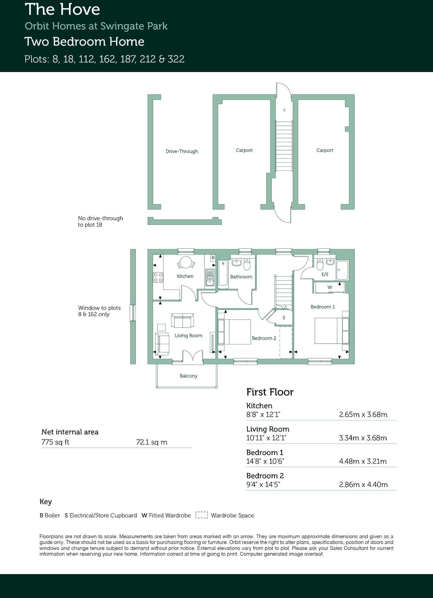
- Two bedroom home floorplan showing kitchen, living room and two bedrooms.
Rooms
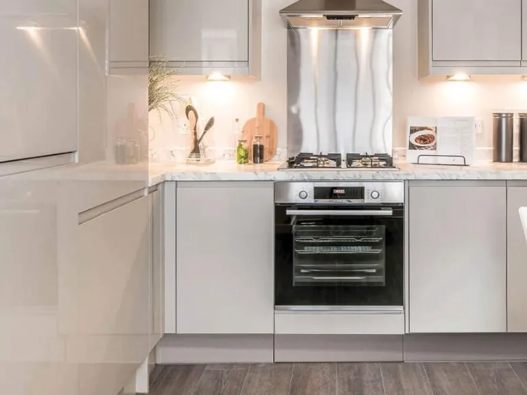
- Kitchen:
- Living Room:
- Bedroom 1:
- Bedroom 2:
Textual Property Features
- Is New Build
- Is Shared Ownership
- Success
Detected Visual Features
- contemporary
- living room
- modern
- light wood
- large window
- natural light
- plants
- neutral tones
- contemporary living room
- feature wallpaper
- modern decor
- well-lit
- wood flooring
- clean
- bright
EPC Details
- Fully double glazed
- Cavity wall, filled cavity
- Boiler and radiators, mains gas
- No low energy lighting
- (other premises below)
Nearby Schools
- Willingdon Community School
- Hailsham Community College
- Grovelands Community Primary School
- Maynards Green Community Primary School
- Pevensey and Westham CofE Primary School
- Burfield Academy
- Park Mead Primary School
- Hellingly Community Primary School
- Herstmonceux Church of England Primary School
- Phoenix Academy
- White House Academy
- Bede's Senior School
- Stone Cross School
- Polegate Primary School
- Hankham Primary School
- Hawkes Farm Academy
- Chiddingly Primary School
- East Hoathly CofE Primary School
Nearest General Shops
- Id: 937099368
- Tags:
- Brand: The Salvation Army
- Brand:wikidata: Q188307
- Brand:wikipedia: en:The Salvation Army
- Building: yes
- Inside: yes
- Name: The Salvation Army
- Shop: charity
- TagsNormalized:
- salvation army
- the salvation army
- charity
- shop
- Lat: 50.8638431
- Lon: 0.2586298
- FullGeoHash: u101mgkr6e86
- PartitionGeoHash: u101
- Images:
- FoodStandards: null
- Distance: 2070.2
,- Id: 1040314848
- Tags:
- Addr:
- City: Hellingly
- Housename: Blackstock Farm
- Postcode: BN27 4HF
- Street: Grove Hill
- Brand: Pricewatch Local, Coop
- Building: yes
- Building:levels: 2
- Email: venues@blackstockestate.co.uk
- Height: 8
- Name: Blackstock Estate Farm Shop
- Not:
- Opening_hours: Mo-Su 07:00-19:00; PH off
- Operator: Blackstock Farm Company Limited
- Organic: yes
- Phone: +44 1323 848 006
- Shop: farm
- Website: https://www.blackstockestate.co.uk/blackstock-farm-shop/
- Wheelchair: limited
- TagsNormalized:
- Lat: 50.8961908
- Lon: 0.2690566
- FullGeoHash: u101w17gv3xh
- PartitionGeoHash: u101
- Images:
- FoodStandards: null
- Distance: 1605.7
,- Id: 1021653674
- Tags:
- Brand: Wolseley
- Brand:wikidata: Q8030423
- Building: yes
- Name: Wolseley
- Shop: trade
- Trade: plumbing
- TagsNormalized:
- Lat: 50.87283
- Lon: 0.2507581
- FullGeoHash: u101mtneenfg
- PartitionGeoHash: u101
- Images:
- FoodStandards: null
- Distance: 1359.7
}
Nearest Grocery shops
- Id: 254189193
- Tags:
- Created_by: Potlatch 0.8
- Shop: convenience
- TagsNormalized:
- Lat: 50.8760644
- Lon: 0.2522354
- FullGeoHash: u101mtxwt9b3
- PartitionGeoHash: u101
- Images:
- FoodStandards: null
- Distance: 1027.6
,- Id: 483917968
- Tags:
- Addr:
- City: Hailsham
- Housename: Provenders Lodge
- Housenumber: 85
- Postcode: BN27 1NX
- Street: Upper Horsebridge Road
- Building: yes
- Fhrs:
- Name: Co-operative Food
- Shop: supermarket
- Source:
- TagsNormalized:
- Lat: 50.8789223
- Lon: 0.25328
- FullGeoHash: u101my0rjye3
- PartitionGeoHash: u101
- Images:
- FoodStandards:
- Id: 178490
- FHRSID: 178490
- LocalAuthorityBusinessID: PI/000047499
- BusinessName: The Co-operative Food
- BusinessType: Retailers - other
- BusinessTypeID: 4613
- AddressLine1: Provenders Lodge
- AddressLine2: 85 Upper Horsebridge
- AddressLine3: Hailsham
- AddressLine4: East Sussex
- PostCode: BN27 1NX
- RatingValue: 5
- RatingKey: fhrs_5_en-GB
- RatingDate: 2021-06-02
- LocalAuthorityCode: 107
- LocalAuthorityName: Wealden
- LocalAuthorityWebSite: http://www.wealden.gov.uk
- LocalAuthorityEmailAddress: envhealth@rother.gov.uk
- Scores:
- Hygiene: 5
- Structural: 5
- ConfidenceInManagement: 5
- NewRatingPending: false
- Geocode:
- Longitude: 0.25263300000000
- Latitude: 50.87890400000000
- Distance: 783.4
,- Id: 6002337133
- Tags:
- Name: Price Watch Local
- Shop: convenience
- TagsNormalized:
- Lat: 50.8770861
- Lon: 0.2638546
- FullGeoHash: u101qjbhs220
- PartitionGeoHash: u101
- Images:
- FoodStandards: null
- Distance: 575.7
}
Nearest Religious buildings
- Id: 442879287
- Tags:
- Addr:
- Postcode: BN27 1AU
- Street: High Street
- Amenity: place_of_worship
- Denomination: methodist
- Fhrs:
- Name: Methodist Church
- Religion: christian
- TagsNormalized:
- place of worship
- methodist
- church
- christian
- Lat: 50.8651733
- Lon: 0.2572236
- FullGeoHash: u101mger1exc
- PartitionGeoHash: u101
- Images:
- FoodStandards: null
- Distance: 1942.8
,- Id: 791344520
- Tags:
- Amenity: place_of_worship
- Building: church
- Denomination: anglican
- Name: Saint Peter & Saint Paul
- Religion: christian
- Wikidata: Q17535397
- TagsNormalized:
- place of worship
- church
- anglican
- paul
- christian
- Lat: 50.8885465
- Lon: 0.2461855
- FullGeoHash: u101mxgr289h
- PartitionGeoHash: u101
- Images:
- FoodStandards: null
- Distance: 1379.7
,- Id: 792937906
- Tags:
- Amenity: place_of_worship
- Building: church
- Denomination: anglican
- Name: Emmanuel
- Religion: christian
- Wikidata: Q105082392
- TagsNormalized:
- place of worship
- church
- anglican
- christian
- Lat: 50.8762034
- Lon: 0.2608413
- FullGeoHash: u101mvtzq59q
- PartitionGeoHash: u101
- Images:
- FoodStandards: null
- Distance: 690.5
}
Nearest Medical buildings
- Id: 1028515944
- Tags:
- Amenity: doctors
- Healthcare: doctor
- Name: NO A+E
- TagsNormalized:
- doctor
- doctors
- health
- healthcare
- Lat: 50.8671526
- Lon: 0.2530718
- FullGeoHash: u101mu069h80
- PartitionGeoHash: u101
- Images:
- FoodStandards: null
- Distance: 1820.3
,- Id: 900793829
- Tags:
- Addr:
- City: Hailsham
- Hamlet: Carters Corner
- Postcode: BN27 4HU
- Street: Cowbeech Road
- Amenity: hospital
- Fhrs:
- Healthcare: hospital
- Name: Amberstone Hospital
- Source:
- Wikidata: Q30293128
- TagsNormalized:
- Lat: 50.8817862
- Lon: 0.2756319
- FullGeoHash: u101qq8xysqj
- PartitionGeoHash: u101
- Images:
- FoodStandards:
- Id: 812884
- FHRSID: 812884
- LocalAuthorityBusinessID: PI/000160147
- BusinessName: Amberstone Hospital Servery
- BusinessType: Hospitals/Childcare/Caring Premises
- BusinessTypeID: 5
- AddressLine1: Amberstone Hospital
- AddressLine2: Cowbeech Road
- AddressLine3: Carters Corner
- AddressLine4: Hailsham
- PostCode: BN27 4HU
- RatingValue: 5
- RatingKey: fhrs_5_en-GB
- RatingDate: 2021-11-24
- LocalAuthorityCode: 107
- LocalAuthorityName: Wealden
- LocalAuthorityWebSite: http://www.wealden.gov.uk
- LocalAuthorityEmailAddress: envhealth@rother.gov.uk
- Scores:
- Hygiene: 5
- Structural: 5
- ConfidenceInManagement: 5
- NewRatingPending: false
- Geocode:
- Longitude: 0.27536700000000
- Latitude: 50.88188100000000
- Distance: 878.7
,- Id: 4764615917
- Tags:
- Addr:
- City: Hailsham
- Place: Herstmonceux
- Street: Hawkswood Road
- Amenity: pharmacy
- Healthcare: pharmacy
- Name: Kamsons Pharmacy
- TagsNormalized:
- Lat: 50.8772071
- Lon: 0.2607479
- FullGeoHash: u101mvvv5yg9
- PartitionGeoHash: u101
- Images:
- FoodStandards: null
- Distance: 584.4
,- Id: 5647193410
- Tags:
- Addr:
- Amenity: doctors
- Healthcare: doctor
- Name: Quintin Medical Centre
- TagsNormalized:
- doctor
- doctors
- health
- healthcare
- Lat: 50.8771334
- Lon: 0.2633648
- FullGeoHash: u101mvzubc54
- PartitionGeoHash: u101
- Images:
- FoodStandards: null
- Distance: 568.4
}
Nearest Leisure Facilities
- Id: 110566317
- Tags:
- TagsNormalized:
- Lat: 50.8880434
- Lon: 0.2678291
- FullGeoHash: u101qpgh2fgg
- PartitionGeoHash: u101
- Images:
- FoodStandards: null
- Distance: 724.4
,- Id: 679290216
- Tags:
- TagsNormalized:
- Lat: 50.8883906
- Lon: 0.265245
- FullGeoHash: u101qpcnket4
- PartitionGeoHash: u101
- Images:
- FoodStandards: null
- Distance: 699.5
,- Id: 679290215
- Tags:
- Leisure: pitch
- Sport: tennis
- Surface: asphalt
- TagsNormalized:
- Lat: 50.8882274
- Lon: 0.2655823
- FullGeoHash: u101qpcmkt0s
- PartitionGeoHash: u101
- Images:
- FoodStandards: null
- Distance: 687.3
,- Id: 679290217
- Tags:
- Leisure: pitch
- Name: Hailsham Cricket Club
- Sport: cricket
- Surface: grass
- TagsNormalized:
- pitch
- leisure
- cricket
- club
- sports
- Lat: 50.8874084
- Lon: 0.2656292
- FullGeoHash: u101qpc2ts7r
- PartitionGeoHash: u101
- Images:
- FoodStandards: null
- Distance: 600.6
,- Id: 9893265218
- Tags:
- TagsNormalized:
- Lat: 50.8802504
- Lon: 0.2562153
- FullGeoHash: u101my6wfnpg
- PartitionGeoHash: u101
- Images:
- FoodStandards: null
- Distance: 533.2
}
Nearest Tourist attractions
- Id: 38444538
- Tags:
- TagsNormalized:
- Lat: 50.856042
- Lon: 0.2756075
- FullGeoHash: u101q609yj7g
- PartitionGeoHash: u101
- Images:
- FoodStandards: null
- Distance: 3042.2
,- Id: 733052310
- Tags:
- Name: Knockhatch Adventure Park
- Tourism: theme_park
- TagsNormalized:
- Lat: 50.8630447
- Lon: 0.2332744
- FullGeoHash: u101m73fewtz
- PartitionGeoHash: u101
- Images:
- FoodStandards: null
- Distance: 2990.9
,- Id: 499881581
- Tags:
- Addr:
- City: Hailsham
- Housename: Bushy Wood Activity Centre
- Postcode: BN27 3LZ
- Street: Hailsham Bypass A22
- Description: Bushy Wood is an Activity Centre located in the heart of rural Sussex, in the south-east of England. We have 17 acres of English woodland, a great venue for a campsite and activity centre, situated adjacent to Hailsham in East Sussex.
- Name: Bushy Wood Activity Centre
- Operator: Eastbourne District Scout Council
- Phone: +44 1323 843713
- Tourism: camp_site
- Website: https://www.bushywood.org.uk
- TagsNormalized:
- Lat: 50.8602653
- Lon: 0.2389401
- FullGeoHash: u101m6vfx8ws
- PartitionGeoHash: u101
- Images:
- FoodStandards: null
- Distance: 2975.4
}
Nearest Train stations
- Id: 1252781690
- Tags:
- Name: Eastbourne Miniature Steam Railway
- Public_transport: station
- Railway: station
- Usage: tourism
- TagsNormalized:
- Lat: 50.7882891
- Lon: 0.2874059
- FullGeoHash: u100yt9r1p33
- PartitionGeoHash: u100
- Images:
- FoodStandards: null
- Distance: 10585.4
,- Id: 6745675396
- Tags:
- Name: Hampden Park
- Naptan:
- Network: National Rail
- Platforms: 2
- Public_transport: station
- Railway: station
- Ref:
- Source: NPE
- Wheelchair: no
- Wikidata: Q2163730
- Wikipedia: en:Hampden Park railway station
- TagsNormalized:
- Lat: 50.7959254
- Lon: 0.2796796
- FullGeoHash: u100yr5etnb1
- PartitionGeoHash: u100
- Images:
- FoodStandards: null
- Distance: 9668.2
,- Id: 6745645283
- Tags:
- Name: Pevensey Bay
- Naptan:
- Network: National Rail
- Public_transport: station
- Railway: station
- Ref:
- Wikidata: Q2721185
- Wikipedia: en:Pevensey Bay railway station
- TagsNormalized:
- Lat: 50.8176698
- Lon: 0.3431985
- FullGeoHash: u101pg1fmh72
- PartitionGeoHash: u101
- Images:
- FoodStandards: null
- Distance: 9118.9
,- Id: 6745645284
- Tags:
- Name: Pevensey and Westham
- Naptan:
- Network: National Rail
- Public_transport: station
- Railway: station
- Ref:
- Wikidata: Q2280818
- Wikipedia: en:Pevensey & Westham railway station
- TagsNormalized:
- Lat: 50.8157704
- Lon: 0.3253781
- FullGeoHash: u101p6szmf5m
- PartitionGeoHash: u101
- Images:
- FoodStandards: null
- Distance: 8586.8
,- Id: 6745675394
- Tags:
- Name: Polegate
- Naptan:
- Network: National Rail
- Public_transport: station
- Railway: station
- Ref:
- Wikidata: Q1928088
- Wikipedia: en:Polegate railway station
- TagsNormalized:
- Lat: 50.8211277
- Lon: 0.2467483
- FullGeoHash: u101jeewt8ug
- PartitionGeoHash: u101
- Images:
- FoodStandards: null
- Distance: 6892.3
}
Nearest Bus stations and stops
- Id: 132726325
- Tags:
- Bus: yes
- Highway: bus_stop
- Public_transport: platform
- TagsNormalized:
- Lat: 50.8780328
- Lon: 0.2549219
- FullGeoHash: u101my1dh0ex
- PartitionGeoHash: u101
- Images:
- FoodStandards: null
- Distance: 742
,- Id: 132726322
- Tags:
- Bus: yes
- Highway: bus_stop
- Public_transport: platform
- TagsNormalized:
- Lat: 50.8785821
- Lon: 0.2544791
- FullGeoHash: u101my1m1z1k
- PartitionGeoHash: u101
- Images:
- FoodStandards: null
- Distance: 730.7
,- Id: 6358761642
- Tags:
- Bus: yes
- Highway: bus_stop
- Name: Chichester Road
- Public_transport: platform
- TagsNormalized:
- Lat: 50.8879589
- Lon: 0.2600437
- FullGeoHash: u101mzv7g7nd
- PartitionGeoHash: u101
- Images:
- FoodStandards: null
- Distance: 671.3
,- Id: 6358761651
- Tags:
- Bus: yes
- Highway: bus_stop
- Name: Chichester Road
- Public_transport: platform
- TagsNormalized:
- Lat: 50.8878177
- Lon: 0.2599106
- FullGeoHash: u101mzv702g2
- PartitionGeoHash: u101
- Images:
- FoodStandards: null
- Distance: 659.6
,- Id: 5759000643
- Tags:
- Bus: yes
- Highway: bus_stop
- Public_transport: platform
- TagsNormalized:
- Lat: 50.8772257
- Lon: 0.2604172
- FullGeoHash: u101mvvtk4m0
- PartitionGeoHash: u101
- Images:
- FoodStandards: null
- Distance: 589.4
}
Nearest Hotels
- Id: 467824007
- Tags:
- Addr:
- City: Hellingly
- Street: Boship Roundabout
- Brand: Travelodge
- Brand:wikidata: Q9361374
- Brand:wikipedia: en:Travelodge UK
- Building: yes
- Name: Travelodge
- Tourism: hotel
- TagsNormalized:
- Lat: 50.8796294
- Lon: 0.2303137
- FullGeoHash: u101mnreqdq7
- PartitionGeoHash: u101
- Images:
- FoodStandards: null
- Distance: 2320.4
,- Id: 104276354
- Tags:
- Building: yes
- Name: Boship Hotel
- Tourism: hotel
- TagsNormalized:
- Lat: 50.8779026
- Lon: 0.2308023
- FullGeoHash: u101mq01606w
- PartitionGeoHash: u101
- Images:
- FoodStandards: null
- Distance: 2318.6
,- Id: 186608067
- Tags:
- Addr:
- City: Hailsham
- Housenumber: 1
- Postcode: BN27 1AD
- Street: George Street
- Amenity: pub
- Brand: Wetherspoon
- Brand:wikidata: Q6109362
- Brand:wikipedia: en:Wetherspoons
- Building: yes
- Internet_access: wlan
- Internet_access:fee: no
- Name: The George Hotel
- Wikidata: Q26295229
- TagsNormalized:
- Lat: 50.8620255
- Lon: 0.2596268
- FullGeoHash: u101mgjhc8zb
- PartitionGeoHash: u101
- Images:
- FoodStandards: null
- Distance: 2261.5
}
Tags
- contemporary
- living room
- modern
- light wood
- large window
- natural light
- plants
- neutral tones
- contemporary living room
- feature wallpaper
- modern decor
- well-lit
- wood flooring
- clean
- bright
Local Market Stats
- Average Price/sqft: £335
- Avg Income: £42000
- Rental Yield: 4.6%
- Social Housing: 6%
- Planning Success Rate: 83%
AirBnB Data
- 1km average: £90/night
- Listings in 1km: 1
Similar Properties
 3 bedroom semi-detached house for sale in New Road
Hellingly
Hailsham
BN27 4EW, BN27 — £360,000 • 3 bed • 1 bath • 667 ft²
3 bedroom semi-detached house for sale in New Road
Hellingly
Hailsham
BN27 4EW, BN27 — £360,000 • 3 bed • 1 bath • 667 ft² 3 bedroom detached house for sale in New Road
Hellingly
Hailsham
BN27 4EW, BN27 — £400,000 • 3 bed • 1 bath • 740 ft²
3 bedroom detached house for sale in New Road
Hellingly
Hailsham
BN27 4EW, BN27 — £400,000 • 3 bed • 1 bath • 740 ft²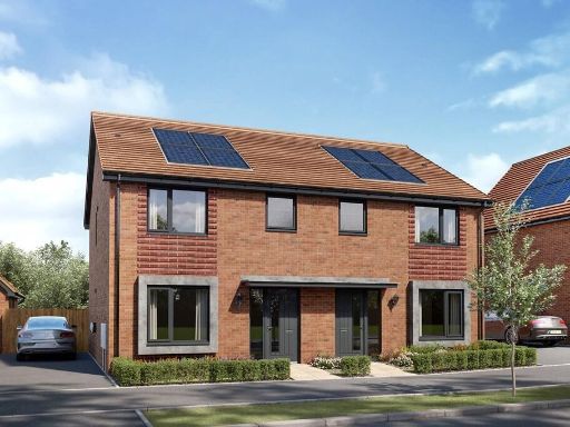 3 bedroom detached house for sale in New Road
Hellingly
Hailsham
BN27 4EW, BN27 — £370,000 • 3 bed • 1 bath • 708 ft²
3 bedroom detached house for sale in New Road
Hellingly
Hailsham
BN27 4EW, BN27 — £370,000 • 3 bed • 1 bath • 708 ft² 3 bedroom detached house for sale in New Road
Hellingly
Hailsham
BN27 4EW, BN27 — £375,000 • 3 bed • 1 bath • 740 ft²
3 bedroom detached house for sale in New Road
Hellingly
Hailsham
BN27 4EW, BN27 — £375,000 • 3 bed • 1 bath • 740 ft² 3 bedroom semi-detached house for sale in New Road
Hellingly
Hailsham
BN27 4EW, BN27 — £354,000 • 3 bed • 1 bath • 708 ft²
3 bedroom semi-detached house for sale in New Road
Hellingly
Hailsham
BN27 4EW, BN27 — £354,000 • 3 bed • 1 bath • 708 ft² 4 bedroom semi-detached house for sale in New Road
Hellingly
Hailsham
BN27 4EW, BN27 — £390,000 • 4 bed • 1 bath • 742 ft²
4 bedroom semi-detached house for sale in New Road
Hellingly
Hailsham
BN27 4EW, BN27 — £390,000 • 4 bed • 1 bath • 742 ft²
Meta
- {
"@context": "https://schema.org",
"@type": "Residence",
"name": "2 bedroom coach house for sale in New Road, Hellingly, Hail…",
"description": "",
"url": "https://propertypiper.co.uk/property/dc380870-d932-4c7b-affc-bf10dee5b3fa",
"image": "https://image-a.propertypiper.co.uk/8ec8369f-e3f6-48c6-a02c-f1e04f2ddb48-1024.jpeg",
"address": {
"@type": "PostalAddress",
"streetAddress": "3 NEW ROAD HELLINGLY HAILSHAM",
"postalCode": "BN27 4EW",
"addressLocality": "Wealden",
"addressRegion": "Wealden",
"addressCountry": "England"
},
"geo": {
"@type": "GeoCoordinates",
"latitude": 50.88224329400206,
"longitude": 0.26312726433597206
},
"numberOfRooms": 2,
"numberOfBathroomsTotal": 2,
"floorSize": {
"@type": "QuantitativeValue",
"value": 775,
"unitCode": "FTK"
},
"offers": {
"@type": "Offer",
"price": 75000,
"priceCurrency": "GBP",
"availability": "https://schema.org/InStock"
},
"additionalProperty": [
{
"@type": "PropertyValue",
"name": "Feature",
"value": "contemporary"
},
{
"@type": "PropertyValue",
"name": "Feature",
"value": "living room"
},
{
"@type": "PropertyValue",
"name": "Feature",
"value": "modern"
},
{
"@type": "PropertyValue",
"name": "Feature",
"value": "light wood"
},
{
"@type": "PropertyValue",
"name": "Feature",
"value": "large window"
},
{
"@type": "PropertyValue",
"name": "Feature",
"value": "natural light"
},
{
"@type": "PropertyValue",
"name": "Feature",
"value": "plants"
},
{
"@type": "PropertyValue",
"name": "Feature",
"value": "neutral tones"
},
{
"@type": "PropertyValue",
"name": "Feature",
"value": "contemporary living room"
},
{
"@type": "PropertyValue",
"name": "Feature",
"value": "feature wallpaper"
},
{
"@type": "PropertyValue",
"name": "Feature",
"value": "modern decor"
},
{
"@type": "PropertyValue",
"name": "Feature",
"value": "well-lit"
},
{
"@type": "PropertyValue",
"name": "Feature",
"value": "wood flooring"
},
{
"@type": "PropertyValue",
"name": "Feature",
"value": "clean"
},
{
"@type": "PropertyValue",
"name": "Feature",
"value": "bright"
}
]
}
High Res Floorplan Images
Compatible Floorplan Images
FloorplanImages Thumbnail