DT1 2QW - 2 bedroom detached bungalow for sale in Roman Road, Dorches…
View on Property Piper
2 bedroom detached bungalow for sale in Roman Road, Dorchester, DT1
Property Details
- Price: £390000
- Bedrooms: 2
- Bathrooms: 1
- Property Type: undefined
- Property SubType: undefined
Image Descriptions
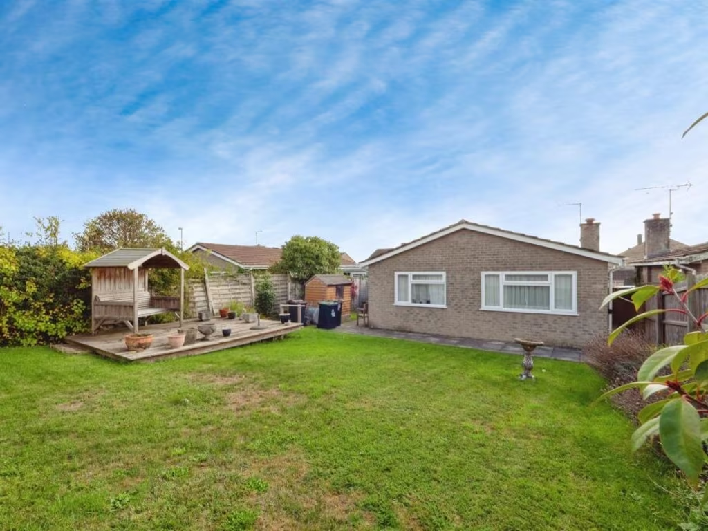
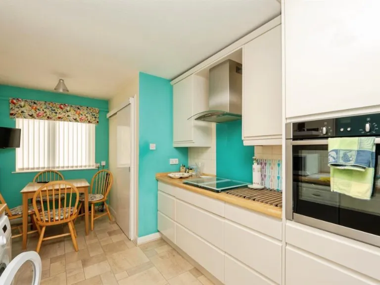
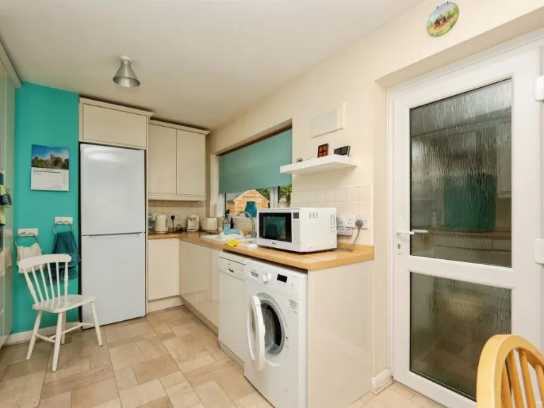
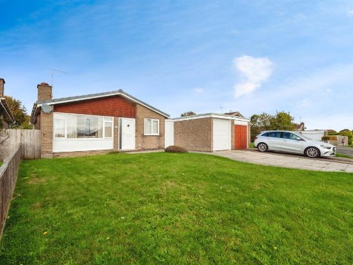
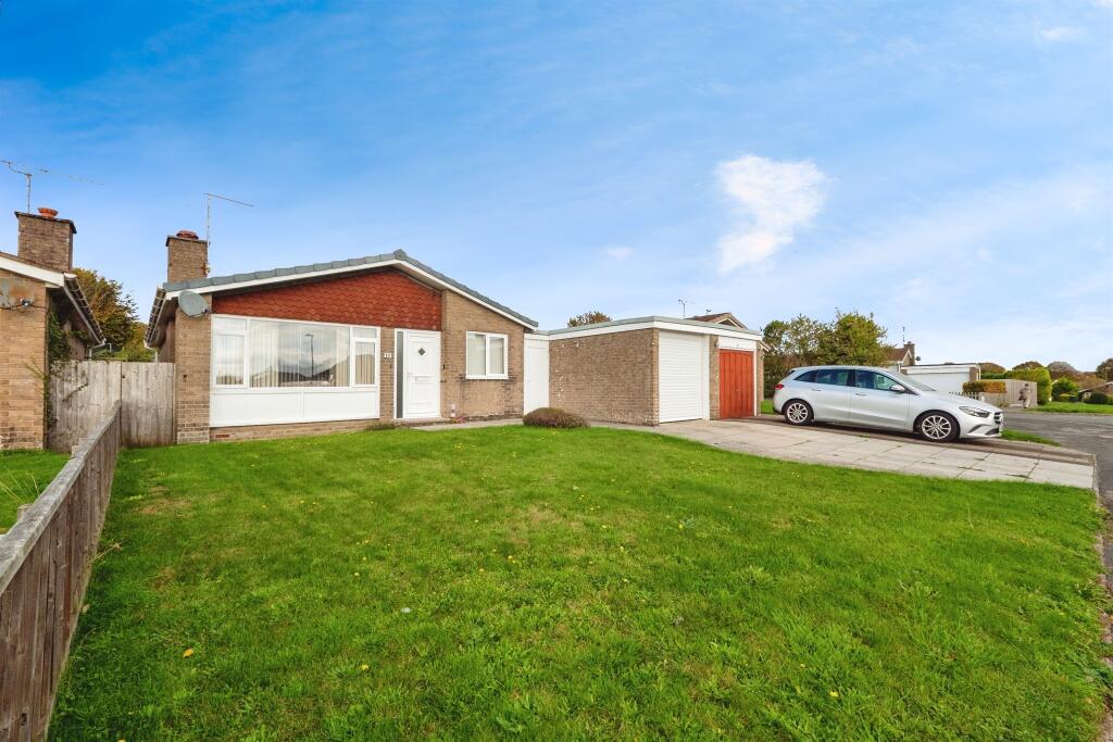
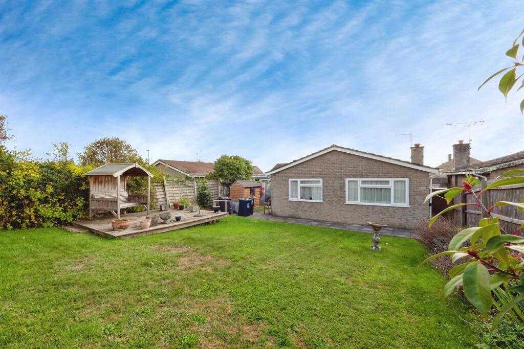
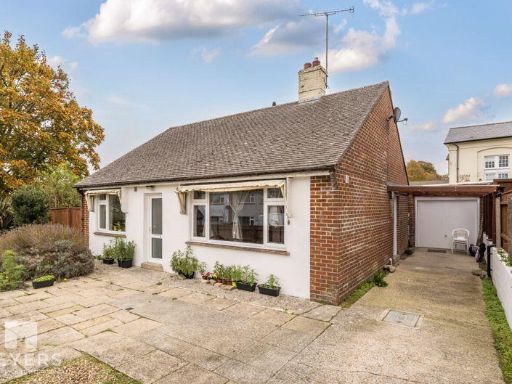
- single-story home with garage mid-20th century bungalow
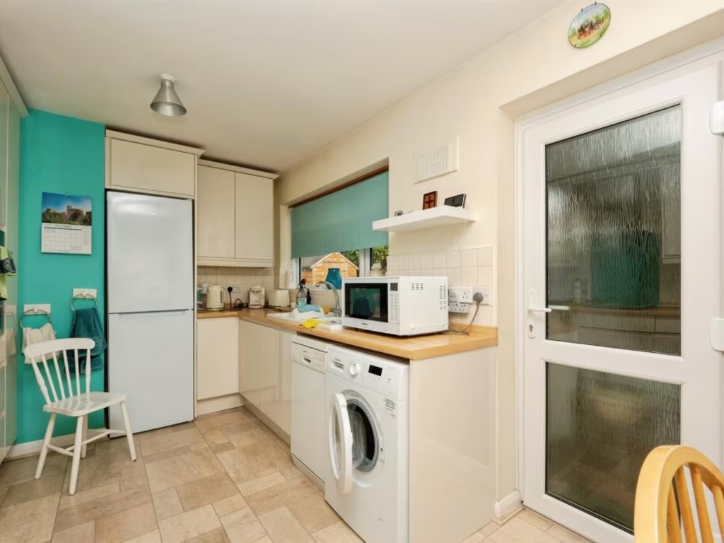
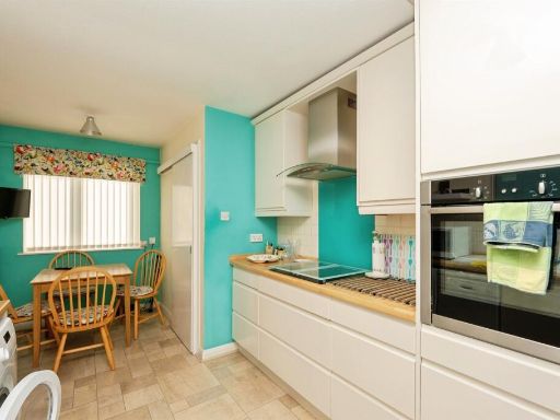
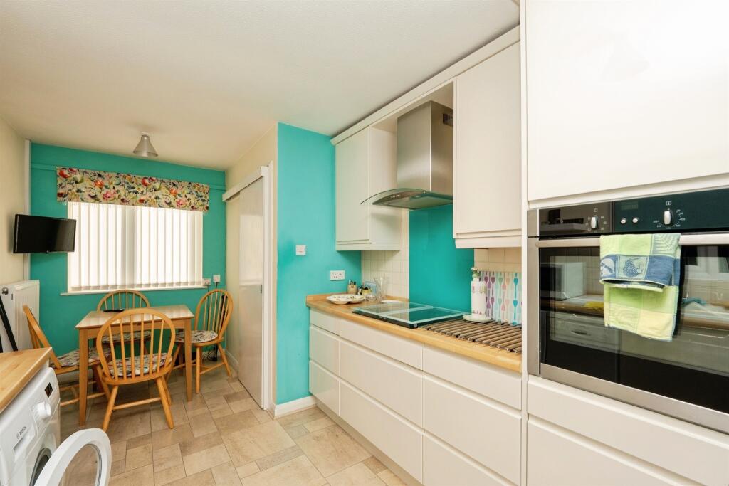
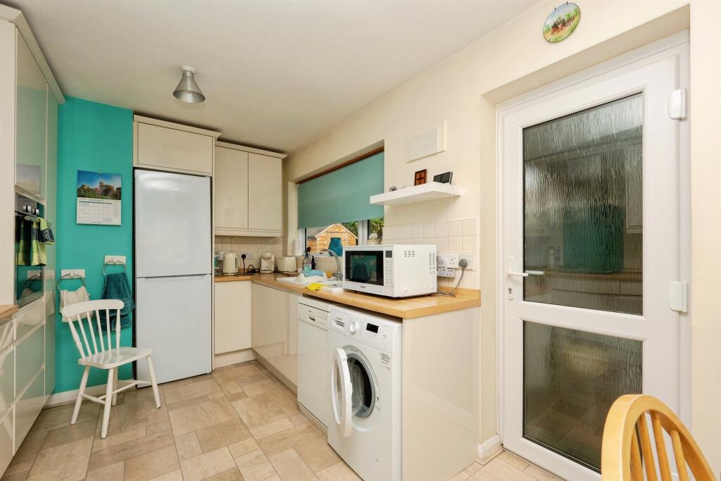
- kitchen modern
Floorplan Description
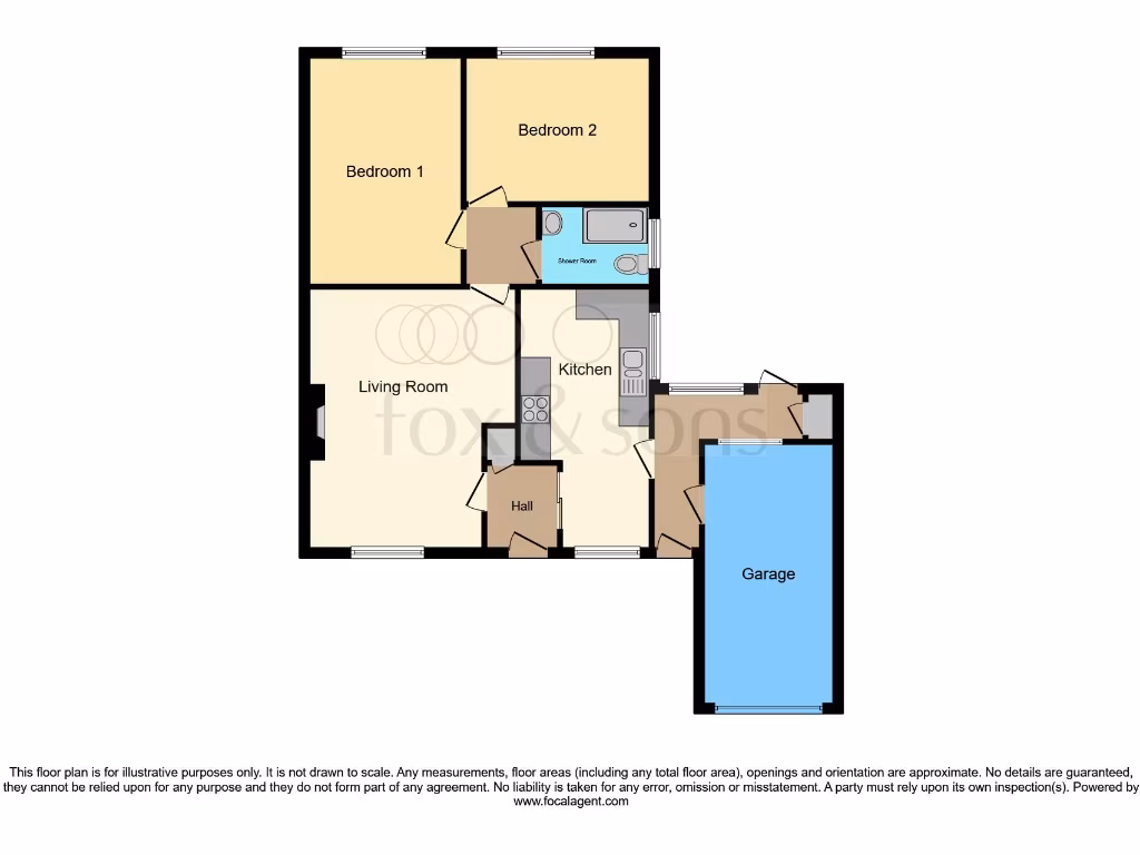
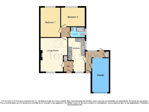
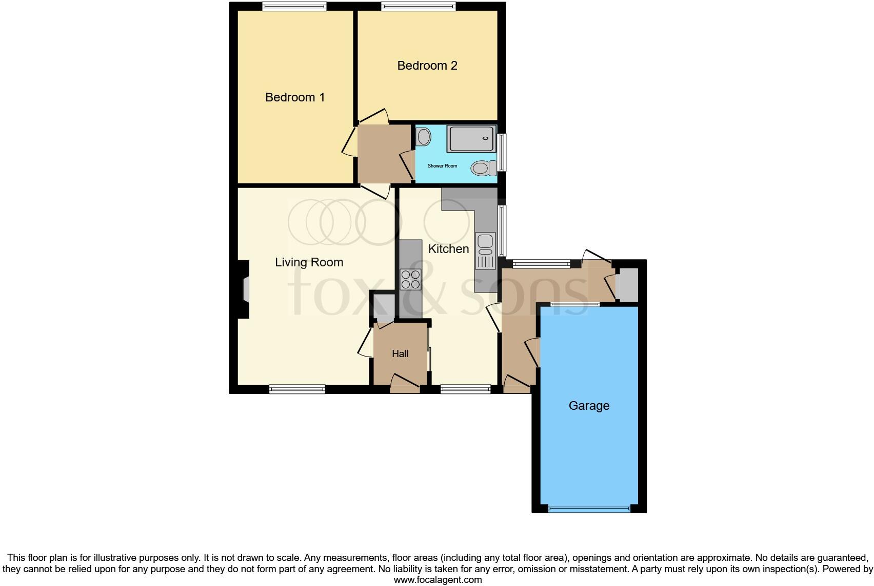
- Single-storey residential floorplan with two bedrooms, living room, kitchen, shower room, hall and garage.
Rooms
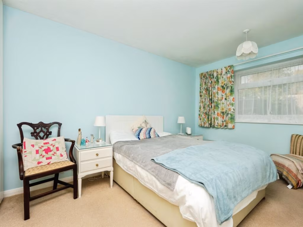
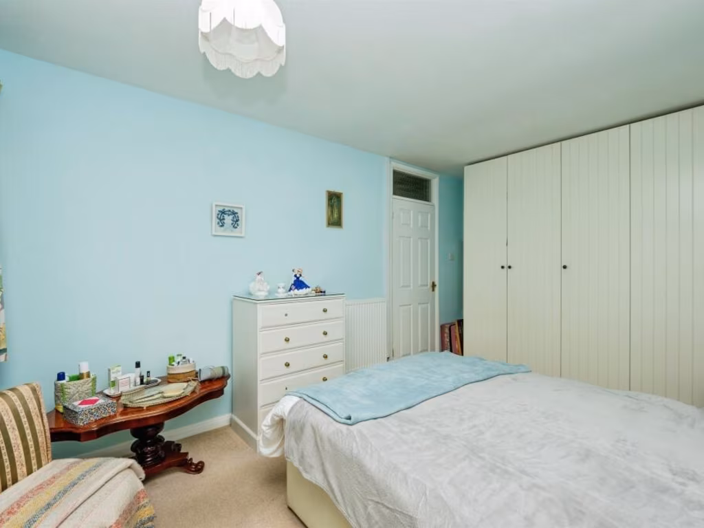
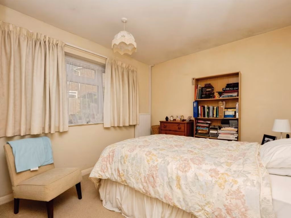
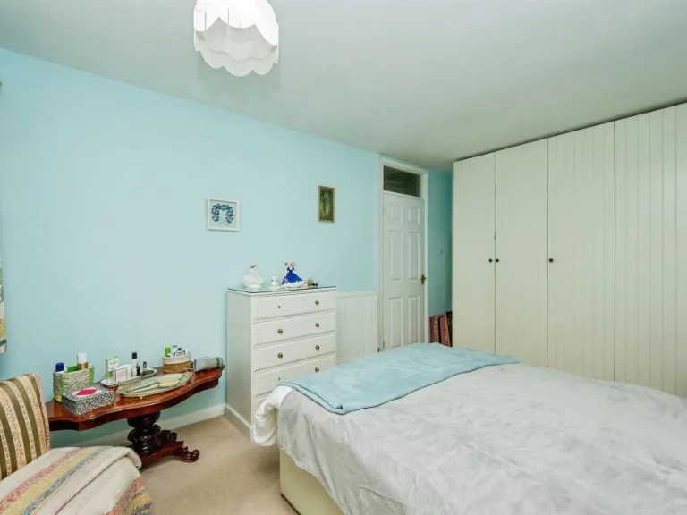
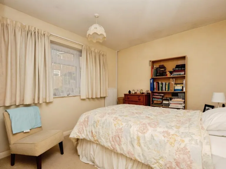
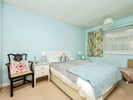
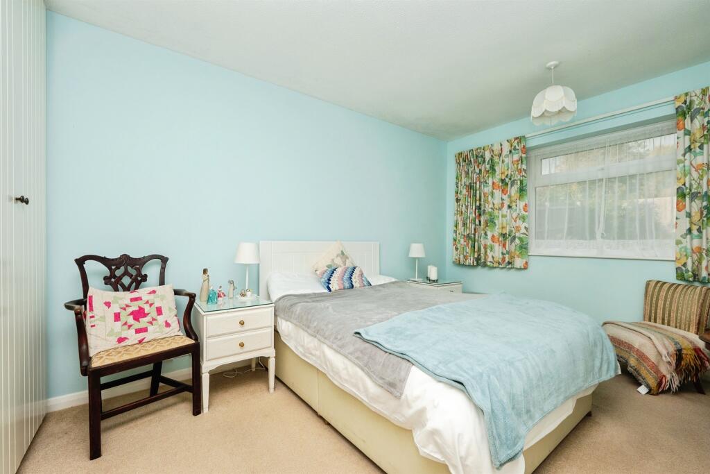
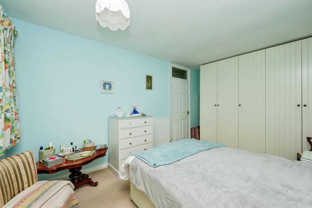
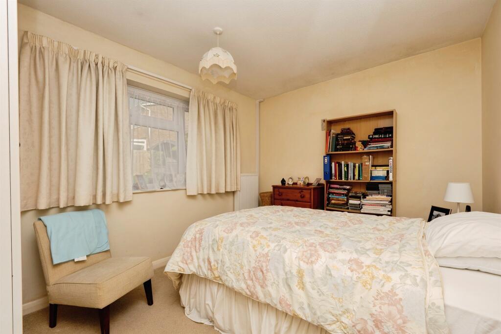
- Bedroom 1:
- Bedroom 2:
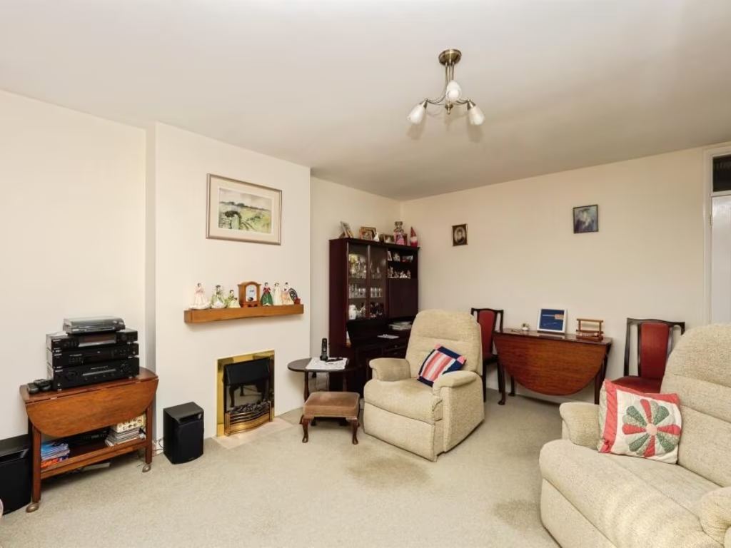
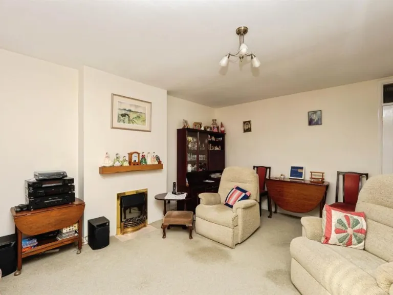
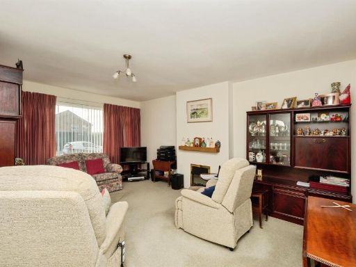
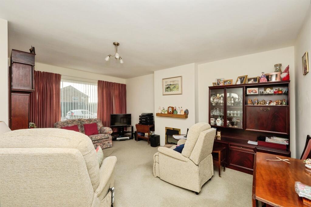
- Living Room:
- Kitchen:
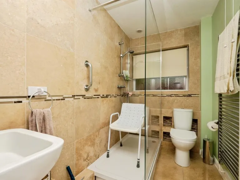
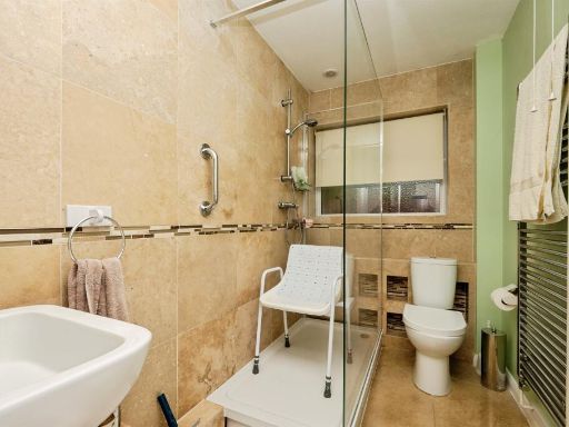
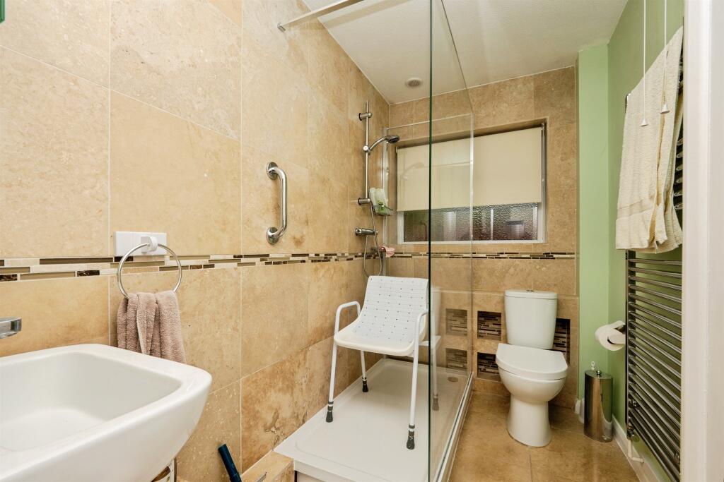
- Shower Room:
- Hall:
- Garage:
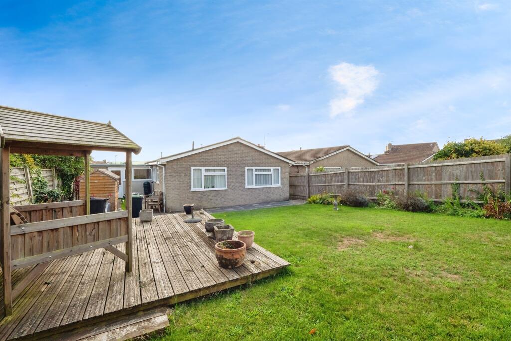
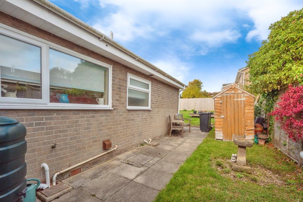
Textual Property Features
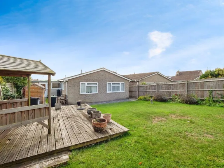
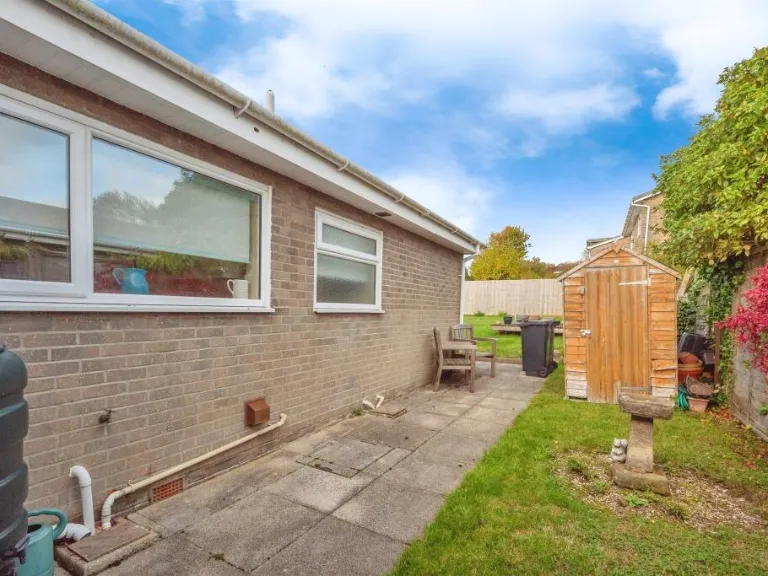
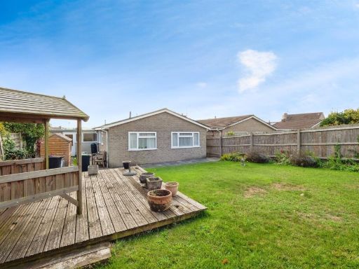
- Has Garden
- Chain Free
- Success
Detected Visual Features
- bungalow
- mid-20th century
- detached
- single-story
- garage
- garden
- suburban
- brick
- driveway
- modern kitchen
- potential fixer-upper
- dated color scheme
- needs modernization
- standard ceiling
- medium room size
- no visible mold
- clean appearance
EPC Details
- Fully double glazed
- Cavity wall, filled cavity
- Boiler and radiators, mains gas
- Low energy lighting in 86% of fixed outlets
- Solid, no insulation (assumed)
Nearby Schools
- St Nicholas and St Laurence Church of England Primary School
- Broadmayne First School
- The Prince of Wales School
- Manor Park Church of England First School
- Winterbourne Valley Church of England Aided First School
- Dorset Studio School
- Puddletown Church of England First School
- Radipole Primary School
- The Thomas Hardye School
- St Mary's Church of England Middle School, Puddletown
- Wey Valley Academy
- Bincombe Valley Primary School
- St Andrew's Church of England Primary School
- St Osmund's Church of England Middle School
- Dorchester Middle School
- St Mary's Catholic First School, Dorchester
- Sunninghill Preparatory School
- Damers First School
- St Mary's Church of England First School, Charminster
Nearest Bars And Restaurants
- Id: 373110929
- Tags:
- Amenity: pub
- Building: yes
- Food: yes
- Microbrewery: yes
- Name: Brewhouse and Kitchen
- Real_ale: yes
- TagsNormalized:
- Lat: 50.7097028
- Lon: -2.4393719
- FullGeoHash: gcn22rrtqt8r
- PartitionGeoHash: gcn2
- Images:
- FoodStandards: null
- Distance: 775.8
,- Id: 4677043808
- Tags:
- Addr:
- Amenity: fast_food
- Brand: Domino's
- Brand:wikidata: Q839466
- Brand:wikipedia: en:Domino's Pizza
- Contact:
- Website: https://www.dominos.co.uk/pizza-near-me/yeovil/5-wyndham-street
- Cuisine: pizza
- Name: Domino's
- Takeaway: yes
- TagsNormalized:
- fast food
- food
- dominos
- pizza
- takeaway
- Lat: 50.7110277
- Lon: -2.4424984
- FullGeoHash: gcn22rtmjstp
- PartitionGeoHash: gcn2
- Images:
- FoodStandards: null
- Distance: 773.1
,- Id: 607345813
- Tags:
- Amenity: pub
- Building: yes
- Name: Georgie Porgie
- TagsNormalized:
- Lat: 50.7111544
- Lon: -2.4432784
- FullGeoHash: gcn22rsvgkre
- PartitionGeoHash: gcn2
- Images:
- FoodStandards: null
- Distance: 765.1
,- Id: 607345805
- Tags:
- Amenity: pub
- Building: yes
- TagsNormalized:
- Lat: 50.7102245
- Lon: -2.4458788
- FullGeoHash: gcn22rdbqyux
- PartitionGeoHash: gcn2
- Images:
- FoodStandards: null
- Distance: 619.6
,- Id: 754671841
- Tags:
- Alt_name: Kentucky Fried Chicken
- Amenity: fast_food
- Brand: KFC
- Brand:wikidata: Q524757
- Brand:wikipedia: en:KFC
- Building: yes
- Contact:
- Website: https://www.kfc.co.uk/kfc-near-me/dorchester-weymouth-avenue
- Cuisine: chicken
- Drive_through: yes
- Name: KFC
- Takeaway: yes
- TagsNormalized:
- fast food
- food
- kfc
- chicken
- drive through
- takeaway
- Lat: 50.7013626
- Lon: -2.4455547
- FullGeoHash: gcn22mghy7n0
- PartitionGeoHash: gcn2
- Images:
- FoodStandards: null
- Distance: 386.2
}
Nearest General Shops
- Id: 350089463
- Tags:
- Brand: currys
- Brand:wikidata: Q3246464
- Building: yes
- Contact:
- Website: https://www.currys.co.uk/store-finder/dorchester--2214.html
- Name: Currys
- Shop: electronics
- TagsNormalized:
- Lat: 50.7029185
- Lon: -2.4447596
- FullGeoHash: gcn22q5vbvp1
- PartitionGeoHash: gcn2
- Images:
- FoodStandards: null
- Distance: 256
,- Id: 465206942
- Tags:
- Building: yes
- Name: Maiden Castle Garage
- Operator: L of a Car
- Shop: car_repair
- Website: https://www.lofacar.com/index.php?id=27
- TagsNormalized:
- garage
- car repair
- repair
- shop
- Lat: 50.7032431
- Lon: -2.4446325
- FullGeoHash: gcn22q5zgctf
- PartitionGeoHash: gcn2
- Images:
- FoodStandards: null
- Distance: 235.5
,- Id: 465206940
- Tags:
- Building: yes
- Name: L of a Car
- Second_hand: yes
- Shop: car
- Website: https://www.lofacar.com/
- TagsNormalized:
- Lat: 50.70345
- Lon: -2.444373
- FullGeoHash: gcn22qk11bpk
- PartitionGeoHash: gcn2
- Images:
- FoodStandards: null
- Distance: 234.7
}
Nearest Grocery shops
- Id: 2080554653
- Tags:
- Addr:
- Housename: St Martin's Place
- Housenumber: Unit A
- Postcode: DT1 2FB
- Street: Bridport Road
- Brand: Sainsbury's Local
- Brand:wikidata: Q13218434
- Brand:wikipedia: en:Sainsbury's Local
- Name: Sainsbury's Local
- Shop: convenience
- TagsNormalized:
- sainsburys
- sainsburys local
- convenience
- shop
- Lat: 50.7138808
- Lon: -2.4479045
- FullGeoHash: gcn2821mz8w4
- PartitionGeoHash: gcn2
- Images:
- FoodStandards: null
- Distance: 1022.3
,- Id: 538728569
- Tags:
- Brand: Spar
- Brand:wikidata: Q610492
- Brand:wikipedia: en:Spar (retailer)
- Building: yes
- Name: Poundbury Village Stores
- Operator: SPAR
- Shop: convenience
- TagsNormalized:
- Lat: 50.7105299
- Lon: -2.4573365
- FullGeoHash: gcn22pdd5zvj
- PartitionGeoHash: gcn2
- Images:
- FoodStandards: null
- Distance: 971.6
,- Id: 4677043814
- Tags:
- Brand: Spar
- Brand:wikidata: Q610492
- Brand:wikipedia: en:Spar (retailer)
- Name: Spar
- Shop: convenience
- TagsNormalized:
- Lat: 50.7103364
- Lon: -2.4463975
- FullGeoHash: gcn22rd94gcg
- PartitionGeoHash: gcn2
- Images:
- FoodStandards: null
- Distance: 628.2
}
Nearest Supermarkets
- Id: 197857808
- Tags:
- Addr:
- Country: GB
- Housenumber: 1
- Postcode: DT1 1XU
- Street: The Grove
- Brand: Lidl
- Brand:wikidata: Q151954
- Brand:wikipedia: en:Lidl
- Building: yes
- Fhrs:
- Name: Lidl
- Shop: supermarket
- TagsNormalized:
- Lat: 50.7182375
- Lon: -2.4409697
- FullGeoHash: gcn282yx1k9p
- PartitionGeoHash: gcn2
- Images:
- FoodStandards:
- Id: 319077
- FHRSID: 319077
- LocalAuthorityBusinessID: 3473
- BusinessName: LIDL UK
- BusinessType: Retailers - supermarkets/hypermarkets
- BusinessTypeID: 7840
- AddressLine1: Lidl The Grove
- AddressLine2: null
- AddressLine3: Dorchester
- AddressLine4: Dorset
- PostCode: DT1 1XU
- RatingValue: 5
- RatingKey: fhrs_5_en-GB
- RatingDate: 2021-05-10
- LocalAuthorityCode: 085
- LocalAuthorityName: Dorset
- LocalAuthorityWebSite: https://www.dorsetcouncil.gov.uk/
- LocalAuthorityEmailAddress: envhealthteamb@dorsetcouncil.gov.uk
- Scores:
- Hygiene: 0
- Structural: 5
- ConfidenceInManagement: 0
- NewRatingPending: false
- Geocode:
- Longitude: -2.44150805473328
- Latitude: 50.71895980834960
- Distance: 1564.8
,- Id: 164180188
- Tags:
- Addr:
- City: Dorchester
- Postcode: DT1 1BN
- Street: Tudor Arcade, South Street
- Brand: Waitrose
- Brand:wikidata: Q771734
- Brand:wikipedia: en:Waitrose
- Building: yes
- Name: Waitrose
- Official_name: Waitrose & Partners
- Opening_hours: Mo-Sa 08:00-20:00; Su 10:00-16:00
- Operator: Waitrose & Partners
- Shop: supermarket
- TagsNormalized:
- Lat: 50.7143102
- Lon: -2.4355062
- FullGeoHash: gcn2886828du
- PartitionGeoHash: gcn2
- Images:
- FoodStandards: null
- Distance: 1342.7
,- Id: 120596053
- Tags:
- Addr:
- Postcode: DT1 2RY
- Street: Weymouth Avenue
- Brand: Tesco
- Brand:wikidata: Q487494
- Brand:wikipedia: en:Tesco
- Building: yes
- Contact:
- Website: https://www.tesco.com/store-locator/dorchester/weymouth-ave
- Name: Tesco
- Ref:
- Shop: supermarket
- TagsNormalized:
- Lat: 50.7016842
- Lon: -2.4439958
- FullGeoHash: gcn22muqdybx
- PartitionGeoHash: gcn2
- Images:
- FoodStandards: null
- Distance: 398.9
}
Nearest Religious buildings
- Id: 4677043795
- Tags:
- Amenity: place_of_worship
- Name: The Storehouse Church
- Religion: christian
- TagsNormalized:
- place of worship
- church
- christian
- Lat: 50.7101632
- Lon: -2.4468883
- FullGeoHash: gcn22rd0p7ef
- PartitionGeoHash: gcn2
- Images:
- FoodStandards: null
- Distance: 607.3
,- Id: 511511308
- Tags:
- Amenity: place_of_worship
- Building: yes
- Denomination: anglican
- Name: Church of St Mary the Virgin
- Religion: christian
- Wikidata: Q17541156
- TagsNormalized:
- place of worship
- anglican
- church
- christian
- Lat: 50.7094324
- Lon: -2.4440592
- FullGeoHash: gcn22rk7c736
- PartitionGeoHash: gcn2
- Images:
- FoodStandards: null
- Distance: 566.7
,- Id: 349932188
- Tags:
- Amenity: place_of_worship
- Building: yes
- Denomination: jehovahs_witness
- Name: Dorchester Kingdom Hall of Jehovah's Witnesses
- Religion: christian
- TagsNormalized:
- place of worship
- jehovah
- jehovahs witness
- christian
- church
- Lat: 50.7010226
- Lon: -2.4471014
- FullGeoHash: gcn22mf4f7su
- PartitionGeoHash: gcn2
- Images:
- FoodStandards: null
- Distance: 409.2
}
Nearest Medical buildings
- Id: 4677043818
- Tags:
- Amenity: pharmacy
- Healthcare: pharmacy
- Name: Victoria Park Pharmacy
- TagsNormalized:
- Lat: 50.7101496
- Lon: -2.4464404
- FullGeoHash: gcn22rd81c1c
- PartitionGeoHash: gcn2
- Images:
- FoodStandards: null
- Distance: 607.2
,- Id: 7504167
- Tags:
- Amenity: hospital
- Building: yes
- Name: The Winterbourne Hospital
- Operator: BMI Healthcare
- Source: local_knowledge
- Source:building: OS_OpenData_StreetView
- Type: multipolygon
- TagsNormalized:
- Lat: 50.7010671
- Lon: -2.442005
- FullGeoHash: gcn22mvg15vj
- PartitionGeoHash: gcn2
- Images:
- FoodStandards: null
- Distance: 538.5
,- Id: 2080543499
- Tags:
- TagsNormalized:
- Lat: 50.7017906
- Lon: -2.4437199
- FullGeoHash: gcn22mux34y3
- PartitionGeoHash: gcn2
- Images:
- FoodStandards: null
- Distance: 400.1
,- Id: 5236952002
- Tags:
- Amenity: hospital
- Healthcare: hospital
- Name: Maiden Castle House
- TagsNormalized:
- Lat: 50.7057852
- Lon: -2.446185
- FullGeoHash: gcn22qdwxg2q
- PartitionGeoHash: gcn2
- Images:
- FoodStandards: null
- Distance: 135.1
}
Nearest Airports
- Id: 386864426
- Tags:
- Aerodrome: international
- Aeroway: aerodrome
- Alt_name: Bournemouth International Airport
- Ele: 12
- Iata: BOH
- Icao: EGHH
- Int_name: B
- Name: Bournemouth Airport
- Old_name: Hurn Airport
- Ref: EGHH
- Source: wikipedia
- Wikidata: Q580409
- Wikipedia: en:Bournemouth Airport
- TagsNormalized:
- airport
- international airport
- Lat: 50.7825186
- Lon: -1.84232
- FullGeoHash: gcn8yhdmwgde
- PartitionGeoHash: gcn8
- Images:
- FoodStandards: null
- Distance: 43421.9
}
Nearest Leisure Facilities
- Id: 154531775
- Tags:
- TagsNormalized:
- Lat: 50.7082359
- Lon: -2.4502739
- FullGeoHash: gcn22ppubkr3
- PartitionGeoHash: gcn2
- Images:
- FoodStandards: null
- Distance: 453.5
,- Id: 321549926
- Tags:
- Leisure: pitch
- Source: bing
- TagsNormalized:
- Lat: 50.7039022
- Lon: -2.4418893
- FullGeoHash: gcn22qmgeu7m
- PartitionGeoHash: gcn2
- Images:
- FoodStandards: null
- Distance: 374.6
,- Id: 243645872
- Tags:
- Leisure: pitch
- Sport: tennis
- TagsNormalized:
- Lat: 50.7029966
- Lon: -2.4425636
- FullGeoHash: gcn22qjqk5se
- PartitionGeoHash: gcn2
- Images:
- FoodStandards: null
- Distance: 368.9
,- Id: 321549947
- Tags:
- Leisure: pitch
- Source: bing
- TagsNormalized:
- Lat: 50.704475
- Lon: -2.4421423
- FullGeoHash: gcn22qmwvznw
- PartitionGeoHash: gcn2
- Images:
- FoodStandards: null
- Distance: 347
,- Id: 321549922
- Tags:
- Leisure: pitch
- Source: bing
- TagsNormalized:
- Lat: 50.7043343
- Lon: -2.4433349
- FullGeoHash: gcn22qky4hvr
- PartitionGeoHash: gcn2
- Images:
- FoodStandards: null
- Distance: 265.2
}
Nearest Tourist attractions
- Id: 446736307
- Tags:
- Building: yes
- Name: Westwood House
- Tourism: guest_house
- TagsNormalized:
- Lat: 50.7149788
- Lon: -2.4400118
- FullGeoHash: gcn282rhpt72
- PartitionGeoHash: gcn2
- Images:
- FoodStandards: null
- Distance: 1245.7
,- Id: 13831551
- Tags:
- Building: yes
- Email: info@keepmilitarymuseum.org
- Museum: military
- Museum_type: regional
- Name: The Keep Military Museum
- Phone: +44 1305 264066
- Toilets: yes
- Tourism: museum
- Type: multipolygon
- Website: http://www.keepmilitarymuseum.org/
- Wheelchair: yes
- Wikidata: Q7744045
- TagsNormalized:
- Lat: 50.7147505
- Lon: -2.443589
- FullGeoHash: gcn282kdu4xy
- PartitionGeoHash: gcn2
- Images:
- FoodStandards: null
- Distance: 1143.6
,- Id: 231784357
- Tags:
- Addr:
- Historic: archaeological_site
- Landuse: grass
- Name: Maumbury Rings
- Tourism: attraction
- Website: http://www.maumburyrings.co.uk/
- Wikidata: Q1702090
- Wikipedia: en:Maumbury Rings
- TagsNormalized:
- Lat: 50.7080273
- Lon: -2.4402202
- FullGeoHash: gcn22rp5dtrv
- PartitionGeoHash: gcn2
- Images:
- FoodStandards: null
- Distance: 607
}
Nearest Train stations
- Id: 75347421
- Tags:
- Name: Wareham
- Naptan:
- Network: National Rail
- Public_transport: station
- Railway: station
- Ref:
- Wikidata: Q2754705
- Wikipedia: en:Wareham railway station
- TagsNormalized:
- Lat: 50.6930546
- Lon: -2.1149086
- FullGeoHash: gcn2ru7urn3c
- PartitionGeoHash: gcn2
- Images:
- FoodStandards: null
- Distance: 23429.1
,- Id: 41954850
- Tags:
- Name: Maiden Newton
- Naptan:
- Network: National Rail
- Platforms: 2
- Public_transport: station
- Railway: station
- Ref:
- Train: yes
- Wikidata: Q2466692
- Wikipedia: en:Maiden Newton railway station
- TagsNormalized:
- Lat: 50.7802255
- Lon: -2.569663
- FullGeoHash: gcn0vs2b680k
- PartitionGeoHash: gcn0
- Images:
- FoodStandards: null
- Distance: 12039.6
,- Id: 3018682209
- Tags:
- Name: Weymouth
- Naptan:
- Network: National Rail
- Public_transport: station
- Railway: station
- Ref:
- Wheelchair: yes
- Wikidata: Q2573733
- Wikipedia: en:Weymouth railway station
- TagsNormalized:
- Lat: 50.6159215
- Lon: -2.4548801
- FullGeoHash: gbyrbnk7j5ss
- PartitionGeoHash: gbyr
- Images:
- FoodStandards: null
- Distance: 9887.4
,- Id: 7170562214
- Tags:
- Name: Dorchester South
- Naptan:
- Network: National Rail
- Operator: South West Trains
- Postal_code: DT1 1QX
- Public_transport: station
- Railway: station
- Ref:
- Source: NPE tracing
- Train: yes
- Wikidata: Q5297623
- Wikipedia: en:Dorchester South railway station
- TagsNormalized:
- Lat: 50.7091366
- Lon: -2.4374501
- FullGeoHash: gcn22x345k1q
- PartitionGeoHash: gcn2
- Images:
- FoodStandards: null
- Distance: 837.1
,- Id: 7170519757
- Tags:
- Name: Dorchester West
- Naptan:
- Network: National Rail
- Operator: Great Western Railway
- Public_transport: station
- Railway: station
- Ref:
- Train: yes
- Wheelchair: yes
- Wikidata: Q5297625
- Wikipedia: en:Dorchester West railway station
- TagsNormalized:
- Lat: 50.7109324
- Lon: -2.4426484
- FullGeoHash: gcn22rtkd4vq
- PartitionGeoHash: gcn2
- Images:
- FoodStandards: null
- Distance: 759.1
}
Nearest Hotels
- Id: 446736305
- Tags:
- Building: yes
- Name: The Wessex Royale Hotel
- Tourism: hotel
- TagsNormalized:
- Lat: 50.7149322
- Lon: -2.4404002
- FullGeoHash: gcn282qgys9d
- PartitionGeoHash: gcn2
- Images:
- FoodStandards: null
- Distance: 1230.2
,- Id: 2546174422
- Tags:
- Brand: Premier Inn
- Brand:wikidata: Q2108626
- Brand:wikipedia: en:Premier Inn
- Internet_access: wlan
- Internet_access:fee: customers
- Internet_access:operator: Virgin Media
- Internet_access:ssid: Premier Inn Free Wi-Fi
- Name: Premier Inn
- Operator: Whitbread
- Tourism: hotel
- TagsNormalized:
- Lat: 50.7096083
- Lon: -2.4376851
- FullGeoHash: gcn22x2uvu4h
- PartitionGeoHash: gcn2
- Images:
- FoodStandards: null
- Distance: 856.2
,- Id: 4677043809
- Tags:
- Amenity: pub
- Name: Victoria Hotel
- TagsNormalized:
- Lat: 50.710209
- Lon: -2.4459093
- FullGeoHash: gcn22rdbqhjg
- PartitionGeoHash: gcn2
- Images:
- FoodStandards: null
- Distance: 617.6
}
Tags
- bungalow
- mid-20th century
- detached
- single-story
- garage
- garden
- suburban
- brick
- driveway
- modern kitchen
- potential fixer-upper
- dated color scheme
- needs modernization
- standard ceiling
- medium room size
- no visible mold
- clean appearance
Local Market Stats
- Average Price/sqft: £336
- Avg Income: £47300
- Rental Yield: 4.3%
- Social Housing: 16%
- Planning Success Rate: 93%
AirBnB Data
- 1km average: £78/night
- Listings in 1km: 2
Similar Properties
 2 bedroom detached bungalow for sale in West Mills Road, Dorchester, DT1 — £325,000 • 2 bed • 1 bath • 865 ft²
 2 bedroom detached bungalow for sale in West Mills Road, Dorchester, DT1 — £345,000 • 2 bed • 1 bath • 797 ft²
 3 bedroom semi-detached house for sale in Barrow Close, Dorchester, DT1 — £365,000 • 3 bed • 1 bath • 1072 ft²
 2 bedroom terraced house for sale in Buckingham Way, Dorchester, DT1 — £250,000 • 2 bed • 1 bath • 472 ft²
 4 bedroom detached house for sale in Celtic Crescent, Dorchester, DT1 — £570,000 • 4 bed • 1 bath • 1893 ft²
 2 bedroom bungalow for sale in Broadmayne, Dorchester, Dorset, DT2 — £350,000 • 2 bed • 1 bath • 916 ft²
Meta
- {
"@context": "https://schema.org",
"@type": "Residence",
"name": "2 bedroom detached bungalow for sale in Roman Road, Dorches…",
"description": "",
"url": "https://propertypiper.co.uk/property/d78815ae-372b-41e8-8036-8db987e727af",
"image": "https://image-a.propertypiper.co.uk/0fc1935f-27be-444a-814f-5fbc5c522cbb-1024.jpeg",
"address": {
"@type": "PostalAddress",
"streetAddress": "10 ROMAN ROAD DORCHESTER",
"postalCode": "DT1 2QW",
"addressLocality": "Dorset",
"addressRegion": "West Dorset",
"addressCountry": "England"
},
"geo": {
"@type": "GeoCoordinates",
"latitude": 50.70470260300646,
"longitude": -2.4470561412805556
},
"numberOfRooms": 2,
"numberOfBathroomsTotal": 1,
"floorSize": {
"@type": "QuantitativeValue",
"value": 711,
"unitCode": "FTK"
},
"offers": {
"@type": "Offer",
"price": 390000,
"priceCurrency": "GBP",
"availability": "https://schema.org/InStock"
},
"additionalProperty": [
{
"@type": "PropertyValue",
"name": "Feature",
"value": "bungalow"
},
{
"@type": "PropertyValue",
"name": "Feature",
"value": "mid-20th century"
},
{
"@type": "PropertyValue",
"name": "Feature",
"value": "detached"
},
{
"@type": "PropertyValue",
"name": "Feature",
"value": "single-story"
},
{
"@type": "PropertyValue",
"name": "Feature",
"value": "garage"
},
{
"@type": "PropertyValue",
"name": "Feature",
"value": "garden"
},
{
"@type": "PropertyValue",
"name": "Feature",
"value": "suburban"
},
{
"@type": "PropertyValue",
"name": "Feature",
"value": "brick"
},
{
"@type": "PropertyValue",
"name": "Feature",
"value": "driveway"
},
{
"@type": "PropertyValue",
"name": "Feature",
"value": "modern kitchen"
},
{
"@type": "PropertyValue",
"name": "Feature",
"value": "potential fixer-upper"
},
{
"@type": "PropertyValue",
"name": "Feature",
"value": "dated color scheme"
},
{
"@type": "PropertyValue",
"name": "Feature",
"value": "needs modernization"
},
{
"@type": "PropertyValue",
"name": "Feature",
"value": "standard ceiling"
},
{
"@type": "PropertyValue",
"name": "Feature",
"value": "medium room size"
},
{
"@type": "PropertyValue",
"name": "Feature",
"value": "no visible mold"
},
{
"@type": "PropertyValue",
"name": "Feature",
"value": "clean appearance"
}
]
}
High Res Floorplan Images
Compatible Floorplan Images
FloorplanImages Thumbnail