CO7 7TL - 3 bedroom end of terrace house for sale in Ardleigh Road, G…
View on Property Piper
3 bedroom end of terrace house for sale in Ardleigh Road, Great Bromley, CO7
Property Details
- Price: £350000
- Bedrooms: 3
- Bathrooms: 1
- Property Type: undefined
- Property SubType: undefined
Brochure Descriptions
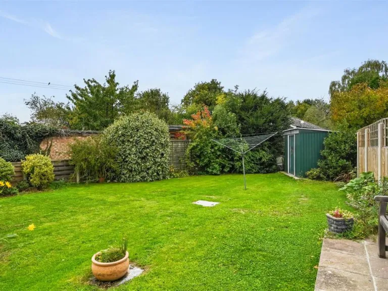
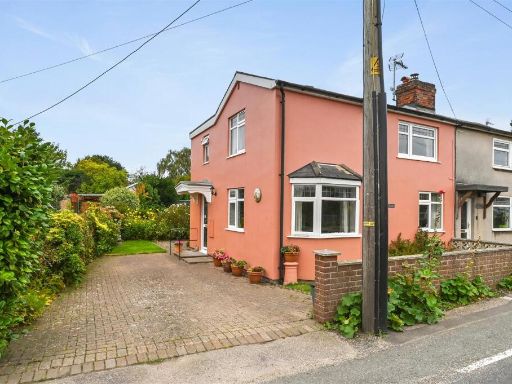
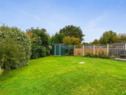
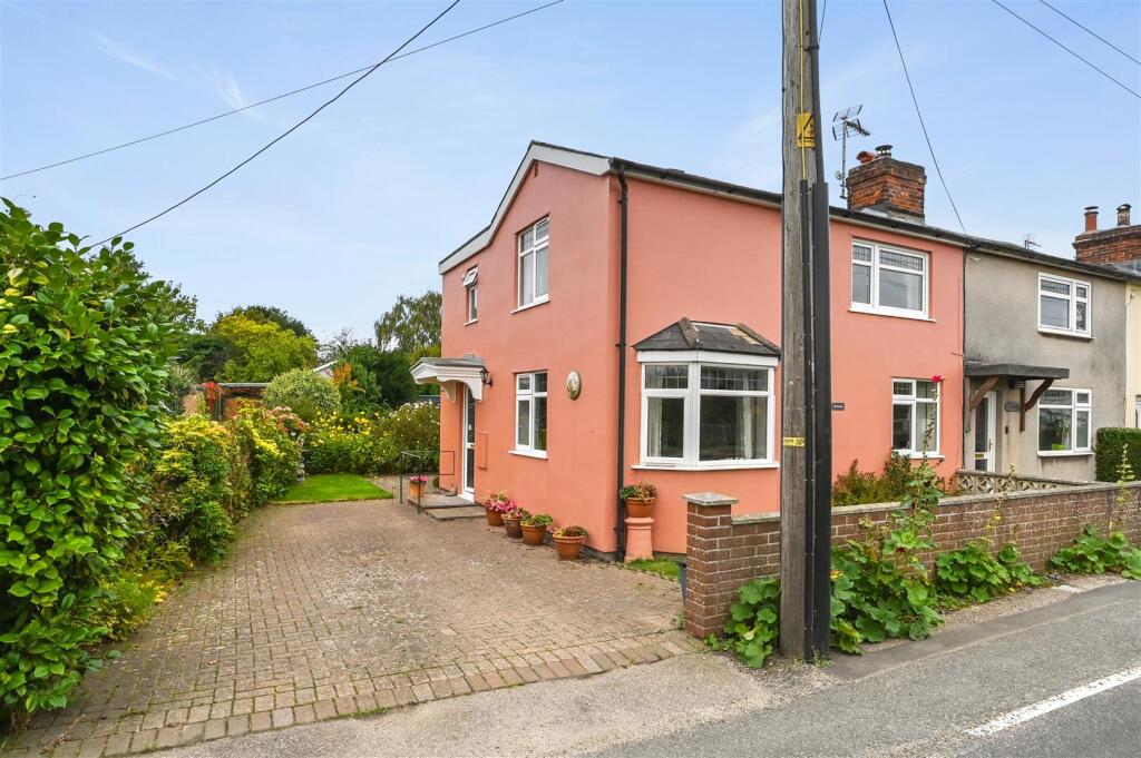
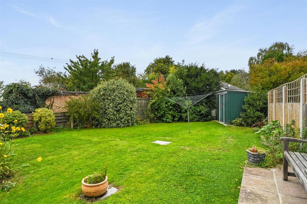
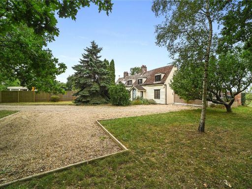
- End-of-terrace two-storey residential property with rendered exterior and bay window to the front. The house has an off-street paved driveway providing parking for at least one to two vehicles, a small paved front area with low brick boundary wall and several potted plants, and a well-vegetated rear garden visible down the side (appears large and mature with shrubs and lawn). The property presents as a mid-20th century style dwelling with a porch entrance, traditional pitched roof and chimney. Overall room sizes appear average for the type; garden size appears above average/large for a village property. Street-facing aspect includes a telegraph/utility pole close to the front boundary. Suitable for buyers seeking a cottage-style family home with good outdoor space and parking.
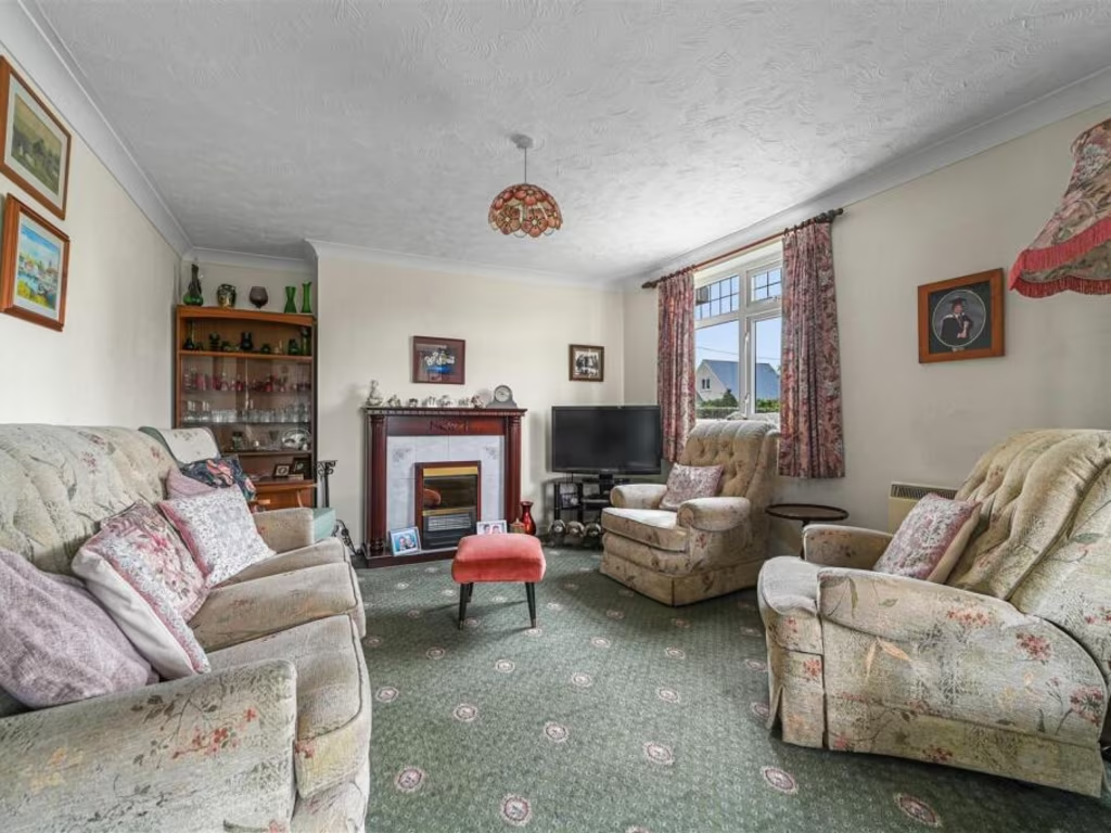
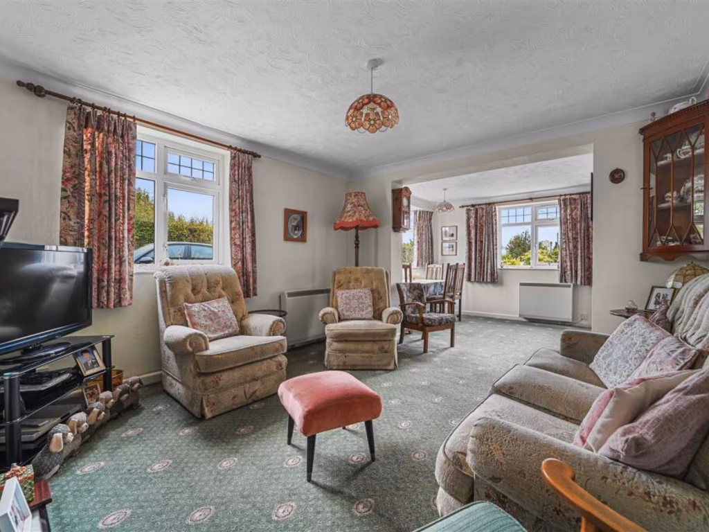
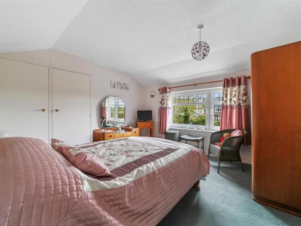
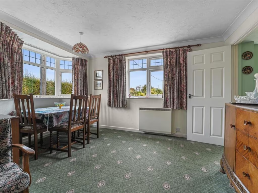
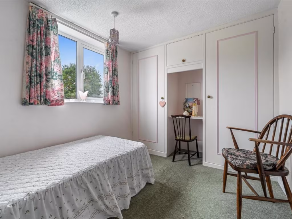
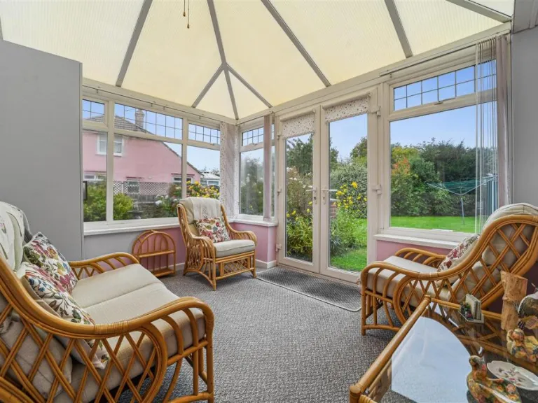
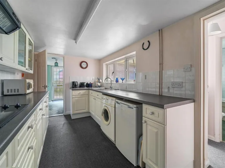
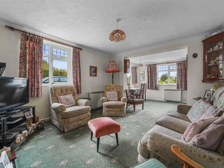
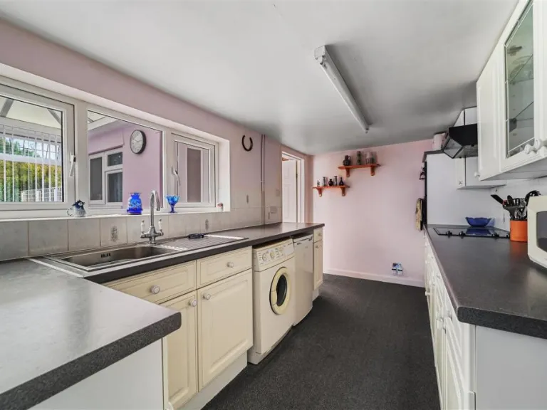
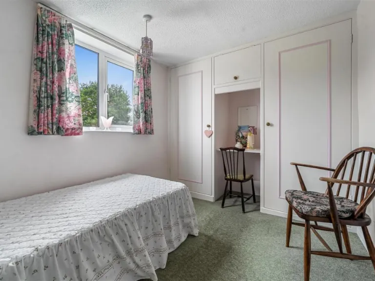
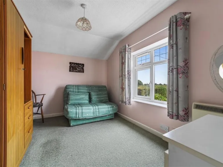
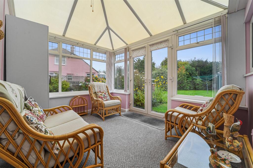
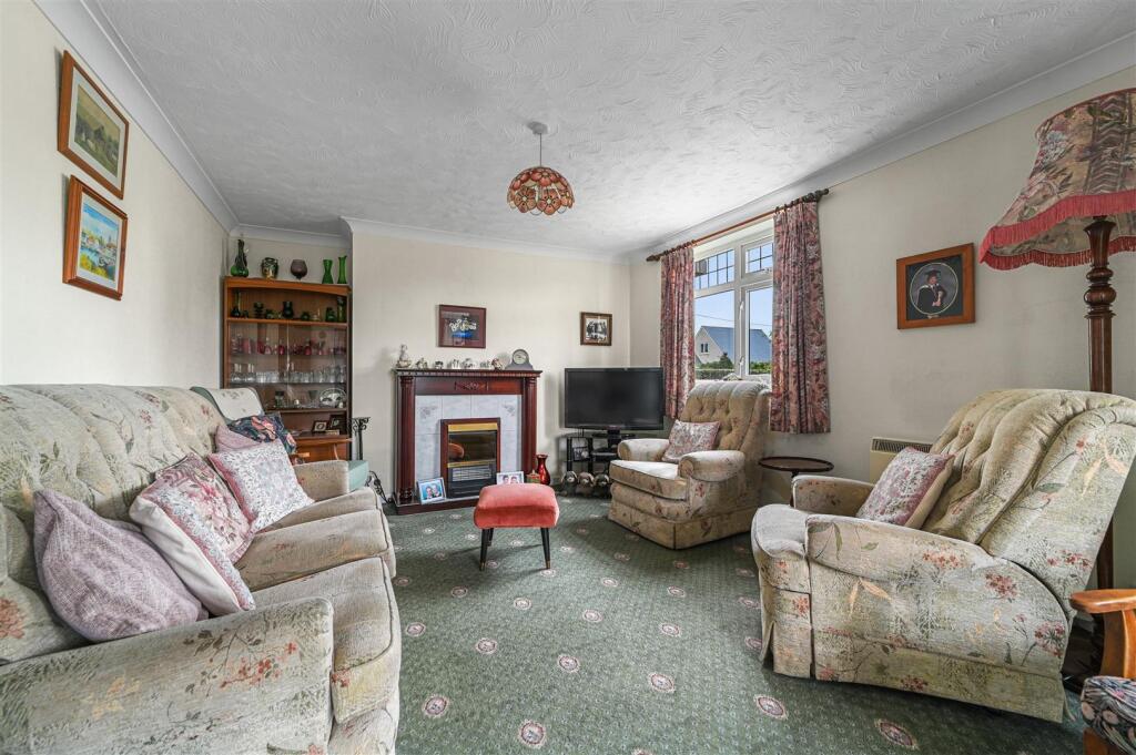
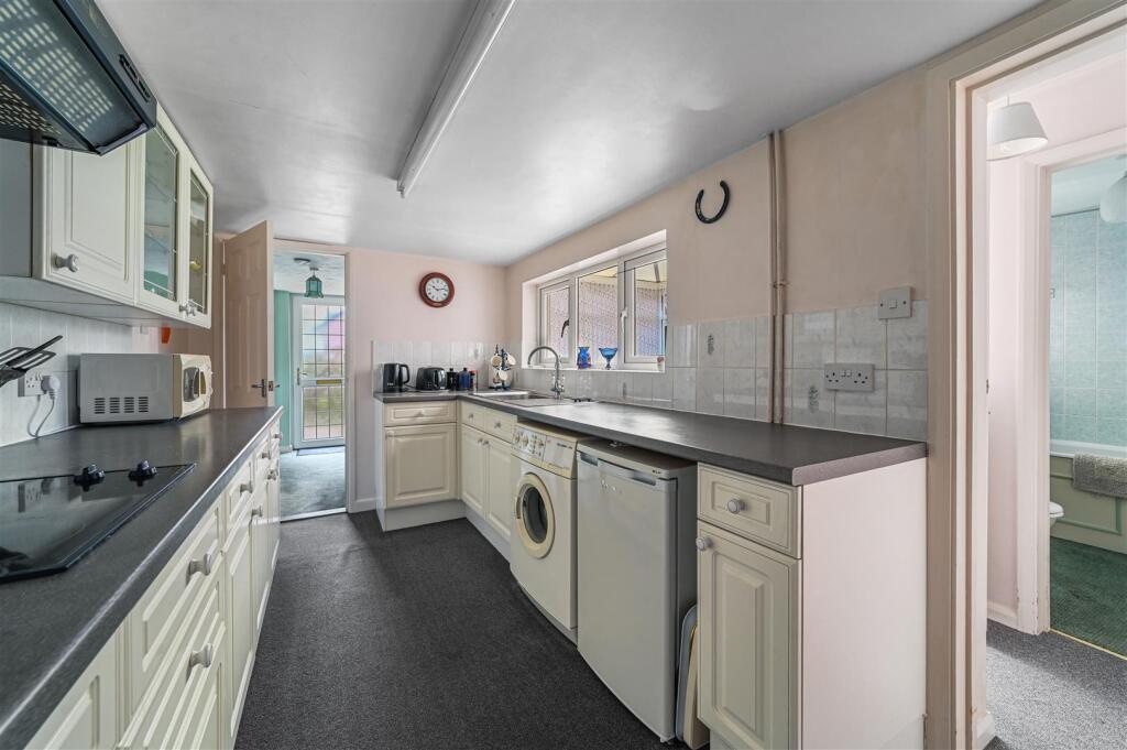
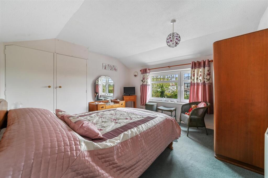
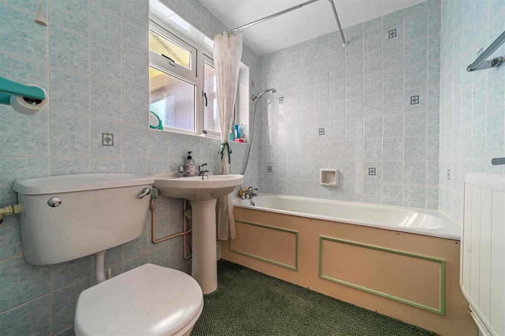
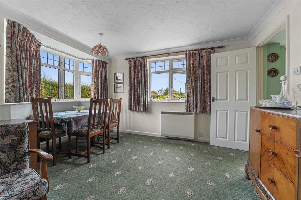
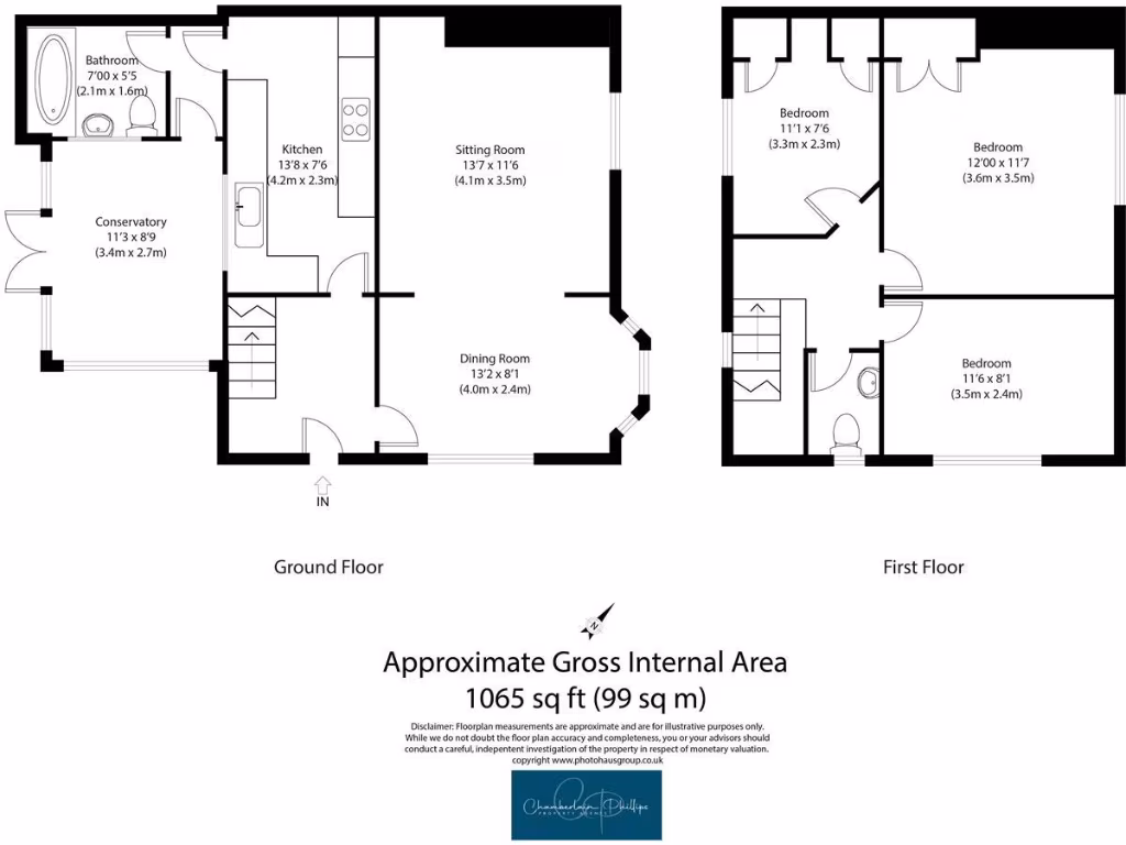
- Two-storey residential dwelling offering approximately 1,065 sq ft (99 sq m) of gross internal area. The accommodation, as shown on the floor plan, comprises a ground floor conservatory, entrance hall, sitting room, separate dining room, kitchen and a ground-floor bathroom. The first floor provides three bedrooms and a family bathroom. The property appears to sit in a semi-rural location (map marker close to Colchester Road / Ardleigh Road) and is likely to benefit from countryside views. The internal layout is traditional with distinct reception rooms and a conservatory providing additional light and usable space. Garden size cannot be measured from the images but the setting on the area map suggests a small-to-average private garden. Overall the property is mid-sized for a family home and would suit purchasers seeking a three-bedroom house in a semi-rural/edge-of-village location.
Image Descriptions
- exterior Edwardian
- garden
Floorplan Description
- Two-storey residential property with conservatory, kitchen, sitting and dining rooms on ground floor and three bedrooms on first floor.
Rooms
- Bathroom:
- Conservatory:
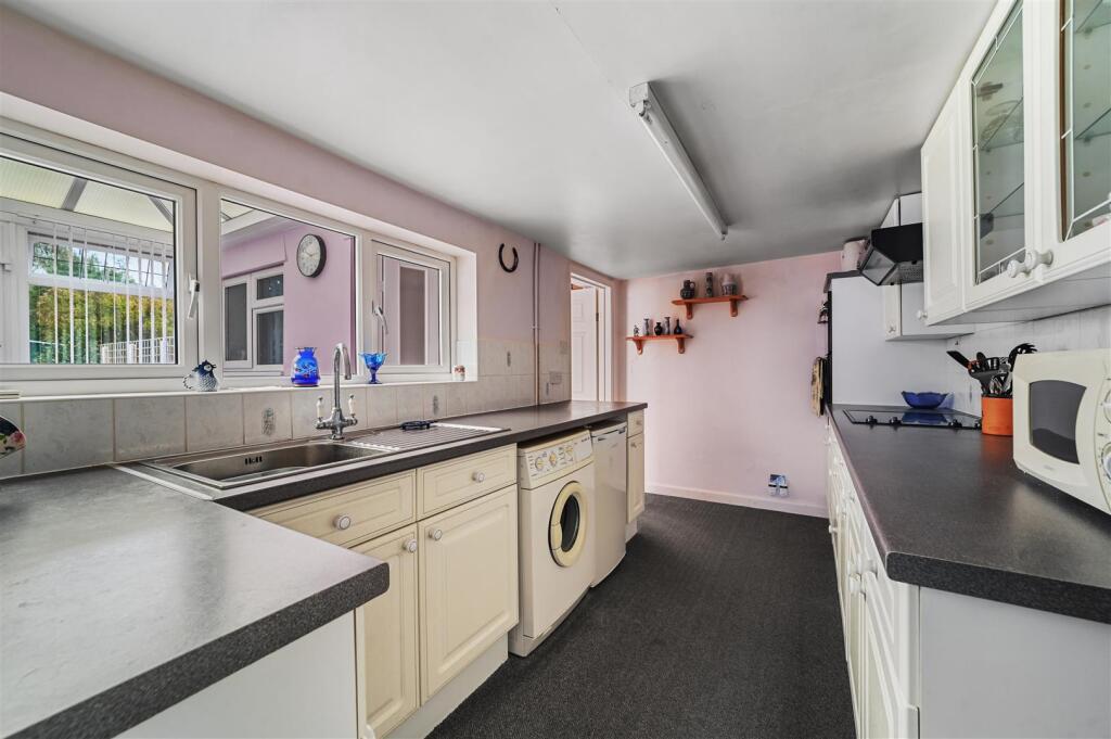
- Kitchen:
- Sitting Room:
- Dining Room:
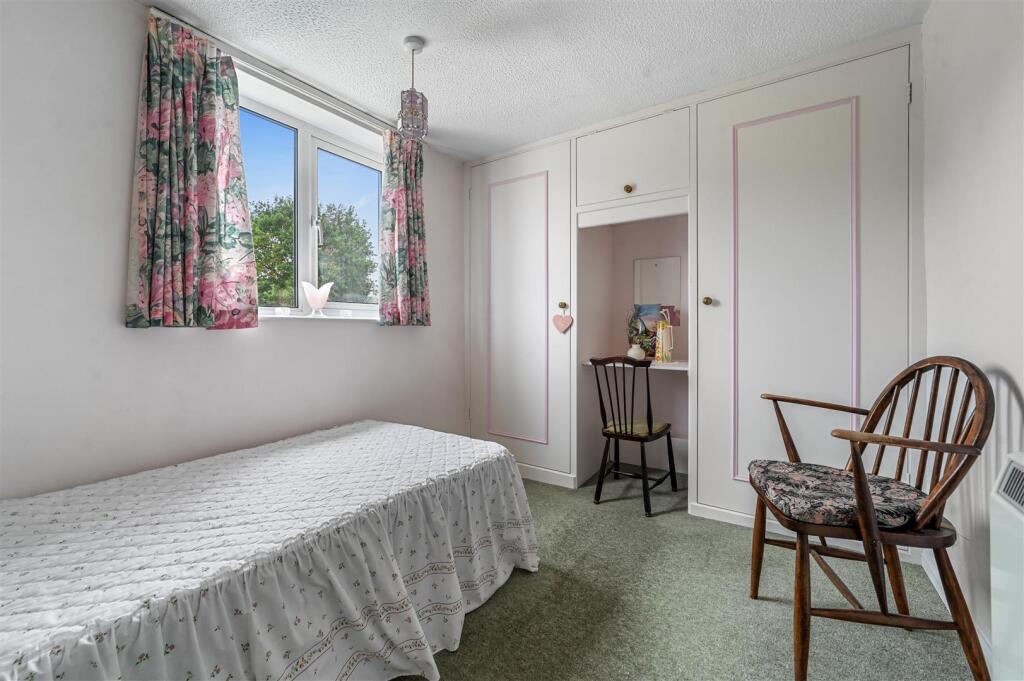
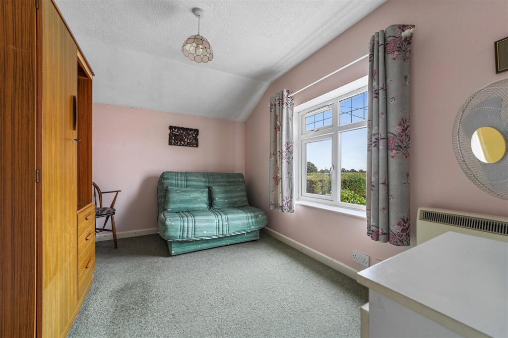
- Bedroom:
- Bedroom:
- Bedroom:
Textual Property Features
Detected Visual Features
- Edwardian
- detached
- two-storey
- driveway
- potential
- charming
- traditional
- character
- well-maintained
- suburban
- garden
- large backyard
- fence
- shed
- storage
- lawn
- green space
EPC Details
- Mostly double glazing
- Cavity wall, filled cavity
- Boiler and radiators, oil
- Low energy lighting in 36% of fixed outlets
- Suspended, no insulation (assumed)
Nearby Schools
- Highfields Primary School
- Millfields Primary School
- Broomgrove Infant School
- Elmstead Primary School
- Unity Primary Academy
- Hazelmere Infant School and Nursery
- Willow Brook Primary School and Nursery
- Brinkley Grove Primary School
- Langham Primary School
- Dedham Church of England Voluntary Controlled Primary School
- Lawford Church of England Voluntary Aided Primary School
- Hazelmere Junior School
- Stratford St Mary Primary School
- Great Bentley Primary School
- Manningtree High School
- East Bergholt Church of England Voluntary Controlled Primary School
- Broomgrove Junior School
- Parsons Heath Church of England Voluntary Controlled Primary School
- Friars Grove Primary School
- St John's Church of England Voluntary Controlled Primary School, Colchester
- Alresford Primary School
- St George's Church of England Primary School, Great Bromley
- Brooklands Primary School
- East Bergholt High School
- St Lawrence Church of England Primary School, Rowhedge
- Colchester Academy
- Roach Vale Primary School
Nearest Bars And Restaurants
- Id: 4299968046
- Tags:
- Amenity: cafe
- Name: The old forge cafe
- Opening_hours: Mo-Fr 09:00-15:45; Sa 09:00-14:45
- Phone: +44 1206828284
- TagsNormalized:
- Lat: 51.8810149
- Lon: 0.9939527
- FullGeoHash: u10xnseubf0u
- PartitionGeoHash: u10x
- Images:
- FoodStandards: null
- Distance: 3080.6
,- Id: 131650911
- Tags:
- Addr:
- City: Ardleigh
- Postcode: CO7 7PA
- Street: Colchester Road
- Amenity: pub
- Building: pub
- Fhrs:
- Name: The Wooden Fender Inn
- Source:
- Website: woodenfendercolchester.co.uk
- TagsNormalized:
- Lat: 51.9215744
- Lon: 0.9718656
- FullGeoHash: u10xqh59n4gx
- PartitionGeoHash: u10x
- Images:
- FoodStandards:
- Id: 611691
- FHRSID: 611691
- LocalAuthorityBusinessID: 1020/FOOD
- BusinessName: Wooden Fender
- BusinessType: Pub/bar/nightclub
- BusinessTypeID: 7843
- AddressLine1: Colchester Road
- AddressLine2: Ardleigh
- AddressLine3: Colchester
- AddressLine4: Essex
- PostCode: CO7 7PA
- RatingValue: 5
- RatingKey: fhrs_5_en-GB
- RatingDate: 2019-05-30
- LocalAuthorityCode: 120
- LocalAuthorityName: Tendring
- LocalAuthorityWebSite: http://www.tendringdc.gov.uk/
- LocalAuthorityEmailAddress: fhsadmin@tendringdc.gov.uk
- Scores:
- Hygiene: 5
- Structural: 5
- ConfidenceInManagement: 0
- NewRatingPending: false
- Geocode:
- Longitude: 0.97291200000000
- Latitude: 51.92275100000000
- Distance: 2725.4
,- Id: 3740315748
- Tags:
- Amenity: cafe
- Name: Seahorse Café
- TagsNormalized:
- Lat: 51.8890795
- Lon: 1.0287996
- FullGeoHash: u10xpqj5uc2x
- PartitionGeoHash: u10x
- Images:
- FoodStandards: null
- Distance: 2660.9
,- Id: 139832036
- Tags:
- Addr:
- Amenity: pub
- Building: yes
- Name: The Lion
- Website: www.thelionardleigh.co.uk
- TagsNormalized:
- Lat: 51.9261724
- Lon: 0.9850965
- FullGeoHash: u10xqkv7fkj5
- PartitionGeoHash: u10x
- Images:
- FoodStandards: null
- Distance: 2442.1
,- Id: 27135447
- Tags:
- Amenity: pub
- Building: yes
- Name: The Cross Inn
- TagsNormalized:
- Lat: 51.9072435
- Lon: 1.0055034
- FullGeoHash: u10xqckjtgt8
- PartitionGeoHash: u10x
- Images:
- FoodStandards: null
- Distance: 85.6
}
Nearest General Shops
- Id: 5926870061
- Tags:
- Addr:
- City: Great Bromley
- Housename: Primrose Pork Farm
- Postcode: CO7 7TR
- Street: Hall Road
- Fhrs:
- Name: Swiss Farm
- Opening_hours: Mo-Sa 08:30-17:30; Su10:00-16:00
- Phone: +44 1206 230454
- Shop: butcher
- Website: https://www.swissfarm.co.uk/
- TagsNormalized:
- Lat: 51.8979111
- Lon: 1.0192737
- FullGeoHash: u10xppwpnzcd
- PartitionGeoHash: u10x
- Images:
- FoodStandards:
- Id: 1042374
- FHRSID: 1042374
- LocalAuthorityBusinessID: 18/00042/FOOD
- BusinessName: Swiss Farm Limited
- BusinessType: Retailers - other
- BusinessTypeID: 4613
- AddressLine1: Primrose Pork Farm
- AddressLine2: Hall Road
- AddressLine3: Great Bromley
- AddressLine4: Colchester
- PostCode: CO7 7TR
- RatingValue: 5
- RatingKey: fhrs_5_en-GB
- RatingDate: 2022-04-18
- LocalAuthorityCode: 120
- LocalAuthorityName: Tendring
- LocalAuthorityWebSite: http://www.tendringdc.gov.uk/
- LocalAuthorityEmailAddress: fhsadmin@tendringdc.gov.uk
- Scores:
- Hygiene: 0
- Structural: 0
- ConfidenceInManagement: 5
- NewRatingPending: false
- Geocode:
- Longitude: 1.01930170000000
- Latitude: 51.89789060000000
- Distance: 1487.7
,- Id: 941353090
- Tags:
- Building: yes
- Name: Swiss Farm
- Opening_hours: Mo-Su
- Shop: farm
- TagsNormalized:
- Lat: 51.8978807
- Lon: 1.0191275
- FullGeoHash: u10xppwp56ht
- PartitionGeoHash: u10x
- Images:
- FoodStandards: null
- Distance: 1483.6
,- Id: 3507075515
- Tags:
- Name: Greensmere Canine Hydrotherapy
- Shop: pet
- Website: http://www.greensmere.co.uk
- TagsNormalized:
- Lat: 51.9083334
- Lon: 1.0052343
- FullGeoHash: u10xqcegzwtj
- PartitionGeoHash: u10x
- Images:
- FoodStandards: null
- Distance: 56
}
Nearest Grocery shops
- Id: 139835348
- Tags:
- Addr:
- Amenity: post_office
- Building: shop
- Name: General Stores
- Operator: Royal Mail
- Shop: convenience
- TagsNormalized:
- office
- post office
- shop
- general
- convenience
- Lat: 51.9270305
- Lon: 0.9855192
- FullGeoHash: u10xqmj8uk06
- PartitionGeoHash: u10x
- Images:
- FoodStandards: null
- Distance: 2506.6
,- Id: 138711894
- Tags:
- Addr:
- Amenity: fast_food
- Building: shop
- Cuisine: fish_and_chips;chinese
- Name: Ardleigh Takeaway
- TagsNormalized:
- fast food
- food
- shop
- fish
- chinese
- takeaway
- Lat: 51.9258606
- Lon: 0.9834152
- FullGeoHash: u10xqku451zx
- PartitionGeoHash: u10x
- Images:
- FoodStandards: null
- Distance: 2479.9
,- Id: 138916653
- Tags:
- Addr:
- Building: shop
- Name: Ardleigh Convenience Store
- Shop: newsagent
- TagsNormalized:
- Lat: 51.9257857
- Lon: 0.9848758
- FullGeoHash: u10xqkv1tk08
- PartitionGeoHash: u10x
- Images:
- FoodStandards: null
- Distance: 2415
}
Nearest Supermarkets
- Id: 110294110
- Tags:
- Addr:
- City: Manningtree
- Housename: Fiveways Superstore
- Postcode: CO11 1US
- Street: Riverside Avenue East
- Branch: East of England Co-operative Food, Manningtree
- Building: shop
- Fhrs:
- Name: Co-op Supermarket
- Opening_hours: Mo-Sa 07:00-21:00; Su 10:00-16:00
- Shop: supermarket
- Url: http://www.eastofengland.coop/store-finder/stores/manningtree-post-office
- Wheelchair: yes
- TagsNormalized:
- Lat: 51.9472647
- Lon: 1.0605624
- FullGeoHash: u10z80sqbbh8
- PartitionGeoHash: u10z
- Images:
- FoodStandards:
- Id: 612138
- FHRSID: 612138
- LocalAuthorityBusinessID: 2653/FOOD
- BusinessName: East of England Co-op
- BusinessType: Retailers - supermarkets/hypermarkets
- BusinessTypeID: 7840
- AddressLine1: Fiveways Superstore
- AddressLine2: Riverside Avenue East
- AddressLine3: Lawford
- AddressLine4: Manningtree
- PostCode: CO11 1US
- RatingValue: 5
- RatingKey: fhrs_5_en-GB
- RatingDate: 2022-11-03
- LocalAuthorityCode: 120
- LocalAuthorityName: Tendring
- LocalAuthorityWebSite: http://www.tendringdc.gov.uk/
- LocalAuthorityEmailAddress: fhsadmin@tendringdc.gov.uk
- Scores:
- Hygiene: 5
- Structural: 0
- ConfidenceInManagement: 5
- NewRatingPending: false
- Geocode:
- Longitude: 1.06017100000000
- Latitude: 51.94622600000000
- Distance: 5810.9
,- Id: 190076257
- Tags:
- Addr:
- City: Colchester
- Postcode: CO1 2TE
- Street: Greenstead Road
- Alt_name: Tesco Colchester Hythe Superstore
- Brand: Tesco
- Brand:wikidata: Q487494
- Brand:wikipedia: en:Tesco
- Building: retail
- Contact:
- Website: https://www.tesco.com/store-locator/colchester/greenstead-rd
- Internet_access: wlan
- Name: Tesco
- Operator: Tesco Stores Ltd
- Shop: supermarket
- Wheelchair: yes
- TagsNormalized:
- tesco
- retail
- supermarket
- shop
- Lat: 51.8848763
- Lon: 0.9296688
- FullGeoHash: u10xjjkgqcgq
- PartitionGeoHash: u10x
- Images:
- FoodStandards: null
- Distance: 5757.8
,- Id: 733736334
- Tags:
- Addr:
- City: Colchester
- Housenumber: 185
- Postcode: CO4 3DB
- Street: Harwich Road
- Building: shop
- Name: Co-op Daily
- Shop: supermarket
- Source:
- TagsNormalized:
- Lat: 51.8942898
- Lon: 0.9267836
- FullGeoHash: u10xjp4f5sgb
- PartitionGeoHash: u10x
- Images:
- FoodStandards: null
- Distance: 5564.6
}
Nearest Religious buildings
- Id: 56474840
- Tags:
- Amenity: place_of_worship
- Building: yes
- Denomination: anglican
- Name: St Mary The Virgin, Little Bromley
- Religion: christian
- Wikidata: Q7594645
- Wikipedia: en:St Mary the Virgin's Church, Little Bromley
- TagsNormalized:
- place of worship
- anglican
- christian
- church
- Lat: 51.9096383
- Lon: 1.0396924
- FullGeoHash: u10xr9v5d9fv
- PartitionGeoHash: u10x
- Images:
- FoodStandards: null
- Distance: 2399
,- Id: 56474839
- Tags:
- Amenity: place_of_worship
- Building: church
- Denomination: anglican
- Name: St George's Church
- Religion: christian
- Wikidata: Q17538948
- TagsNormalized:
- place of worship
- church
- anglican
- christian
- Lat: 51.8962064
- Lon: 1.0269529
- FullGeoHash: u10xpr7v3dp9
- PartitionGeoHash: u10x
- Images:
- FoodStandards: null
- Distance: 1997.9
,- Id: 55616728
- Tags:
- Addr:
- Amenity: place_of_worship
- Denomination: anglican
- Name: St Anne & St Laurence, Elmstead Market
- Religion: christian
- Website: elmsteadparishchurch.org
- Wikidata: Q17538914
- TagsNormalized:
- place of worship
- anglican
- christian
- church
- Lat: 51.8943785
- Lon: 0.9998244
- FullGeoHash: u10xnz049t71
- PartitionGeoHash: u10x
- Images:
- FoodStandards: null
- Distance: 1541.6
}
Nearest Medical buildings
- Id: 669771447
- Tags:
- Amenity: doctors
- Building: yes
- Healthcare: doctor
- Name: The Hawthorn Surgery
- TagsNormalized:
- doctor
- doctors
- health
- healthcare
- surgery
- Lat: 51.8916206
- Lon: 0.9361962
- FullGeoHash: u10xjq9dwgnq
- PartitionGeoHash: u10x
- Images:
- FoodStandards: null
- Distance: 5045.1
,- Id: 733912369
- Tags:
- Addr:
- City: Colchester
- Housenumber: 338
- Postcode: CO4 3HP
- Street: Harwich Road
- Amenity: pharmacy
- Building: house
- Dispensing: yes
- Name: Day Lewis Pharmacy
- Source:
- TagsNormalized:
- pharmacy
- day lewis pharmacy
- Lat: 51.8972624
- Lon: 0.9353171
- FullGeoHash: u10xjr956qyu
- PartitionGeoHash: u10x
- Images:
- FoodStandards: null
- Distance: 4913.8
,- Id: 110300008
- Tags:
- Addr:
- City: Manningtree
- Housenumber: 2
- Postcode: CO11 2HD
- Amenity: doctors
- Building: yes
- Name: Lawford Surgery
- Website: https://www.nhs.uk/ServiceDirectories/Pages/GP.aspx?pid=786B7B78-28D5-4186-B2D7-1D59E8C85AD1
- TagsNormalized:
- Lat: 51.9407245
- Lon: 1.050237
- FullGeoHash: u10xrzsb8kc6
- PartitionGeoHash: u10x
- Images:
- FoodStandards: null
- Distance: 4797.9
,- Id: 733983880
- Tags:
- Amenity: clinic
- Building: yes
- Name: Parsons Heath Medical Practice
- Source:
- TagsNormalized:
- Lat: 51.8983937
- Lon: 0.9380343
- FullGeoHash: u10xjrg41cc1
- PartitionGeoHash: u10x
- Images:
- FoodStandards: null
- Distance: 4703.1
}
Nearest Leisure Facilities
- Id: 941515872
- Tags:
- Access: private
- Leisure: swimming_pool
- Location: outdoor
- TagsNormalized:
- swimming
- swimming pool
- pool
- leisure
- Lat: 51.9075601
- Lon: 0.9862602
- FullGeoHash: u10xq3qpmw8c
- PartitionGeoHash: u10x
- Images:
- FoodStandards: null
- Distance: 1274.8
,- Id: 161757532
- Tags:
- Leisure: park
- Name: Green Island Gardens
- Website: https://www.greenislandgardens.co.uk/
- TagsNormalized:
- Lat: 51.9061806
- Lon: 0.9880115
- FullGeoHash: u10xq3prqm6g
- PartitionGeoHash: u10x
- Images:
- FoodStandards: null
- Distance: 1169.7
,- Id: 71763810
- Tags:
- Access: private
- Leisure: swimming_pool
- Source: OS_OpenData_VectorDistrict
- TagsNormalized:
- swimming
- swimming pool
- pool
- leisure
- Lat: 51.9047863
- Lon: 0.9890551
- FullGeoHash: u10xq8bpq9ky
- PartitionGeoHash: u10x
- Images:
- FoodStandards: null
- Distance: 1136.4
,- Id: 941515881
- Tags:
- Access: private
- Leisure: pitch
- Sport: tennis
- TagsNormalized:
- Lat: 51.9050675
- Lon: 0.9896762
- FullGeoHash: u10xq908vjuh
- PartitionGeoHash: u10x
- Images:
- FoodStandards: null
- Distance: 1086.4
,- Id: 941515882
- Tags:
- Leisure: pitch
- Sport: tennis
- TagsNormalized:
- Lat: 51.9061906
- Lon: 0.9899535
- FullGeoHash: u10xq90z7x4z
- PartitionGeoHash: u10x
- Images:
- FoodStandards: null
- Distance: 1038.3
}
Nearest Tourist attractions
- Id: 344474126
- Tags:
- Addr:
- City: Great Bromley
- Housename: Mill Farm
- Postcode: CO7 7JQ
- Street: Harwich Road
- Name: Mill Farm Camp Site
- Tourism: camp_site
- Url: http://www.aroundaboutbritain.co.uk/Essex/10843
- TagsNormalized:
- Lat: 51.880823
- Lon: 1.0156827
- FullGeoHash: u10xpheeen7g
- PartitionGeoHash: u10x
- Images:
- FoodStandards: null
- Distance: 3100.8
,- Id: 140834627
- Tags:
- Addr:
- Housename: Island Lodge
- Postcode: CO7 7QA
- Building: yes
- Tourism: chalet
- Website: homepage.ntlworld.com/d.dennis7
- TagsNormalized:
- Lat: 51.9297533
- Lon: 0.9815663
- FullGeoHash: u10xqmdb8psu
- PartitionGeoHash: u10x
- Images:
- FoodStandards: null
- Distance: 2907.8
,- Id: 161757553
- Tags:
- Addr:
- Building: yes
- Name: Park Cottage
- Tourism: guest_house
- Website: www.parkcottage.org
- TagsNormalized:
- Lat: 51.9096666
- Lon: 0.9911775
- FullGeoHash: u10xq9cg8p5w
- PartitionGeoHash: u10x
- Images:
- FoodStandards: null
- Distance: 957.4
}
Nearest Train stations
- Id: 2393234119
- Tags:
- Name: Wrabness
- Naptan:
- Network: National Rail
- Public_transport: station
- Railway: station
- Ref:
- Wikidata: Q3284262
- Wikipedia: en:Wrabness railway station
- TagsNormalized:
- Lat: 51.9395281
- Lon: 1.1716892
- FullGeoHash: u10z6xm1wmfc
- PartitionGeoHash: u10z
- Images:
- FoodStandards: null
- Distance: 11970.5
,- Id: 8061429385
- Tags:
- Name: Colchester
- Naptan:
- Network: National Rail
- Public_transport: station
- Railway: station
- Ref:
- Start_date: 1843-03-29
- Train: yes
- Wikidata: Q2750618
- Wikipedia: en:Colchester railway station
- TagsNormalized:
- Lat: 51.9005793
- Lon: 0.8924554
- FullGeoHash: u10xk21yg9ny
- PartitionGeoHash: u10x
- Images:
- Q2750618-1
- Q2750618-2
- Q2750618-3
- FoodStandards: null
- Distance: 7752.6
,- Id: 26579230
- Tags:
- Name: Colchester Town
- Naptan:
- Network: National Rail
- Old_name: St Botolph's
- Operator: Abellio Greater Anglia
- Platforms: 1
- Public_transport: station
- Railway: station
- Ref:
- Wikidata: Q4489756
- Wikipedia: en:Colchester Town railway station
- TagsNormalized:
- Lat: 51.8865086
- Lon: 0.9054279
- FullGeoHash: u10xhtekcfpz
- PartitionGeoHash: u10x
- Images:
- FoodStandards: null
- Distance: 7223.5
,- Id: 1643615541
- Tags:
- Name: Hythe (Colchester)
- Naptan:
- Network: National Rail
- Public_transport: station
- Railway: station
- Ref:
- Train: yes
- Wikidata: Q2552020
- Wikipedia: en:Hythe railway station (Essex)
- TagsNormalized:
- Lat: 51.8858134
- Lon: 0.9275278
- FullGeoHash: u10xjje2ubwu
- PartitionGeoHash: u10x
- Images:
- FoodStandards: null
- Distance: 5845.2
,- Id: 2006158761
- Tags:
- Name: Manningtree
- Naptan:
- Network: National Rail
- Public_transport: station
- Railway: station
- Ref:
- Start_date: 1846
- Wikidata: Q1938819
- Wikipedia: en:Manningtree railway station
- TagsNormalized:
- Lat: 51.9491435
- Lon: 1.0449277
- FullGeoHash: u10xxc0csw4x
- PartitionGeoHash: u10x
- Images:
- FoodStandards: null
- Distance: 5347.5
}
Nearest Bus stations and stops
- Id: 9082683136
- Tags:
- Highway: bus_stop
- Name: Ardleigh Church
- Naptan:
- Note: location guessed from name - not in naptan yet (temporary reference in timetable data)
- Public_transport: platform
- TagsNormalized:
- Lat: 51.9261417
- Lon: 0.9856488
- FullGeoHash: u10xqkvexq3h
- PartitionGeoHash: u10x
- Images:
- FoodStandards: null
- Distance: 2418.5
,- Id: 9082683135
- Tags:
- Highway: bus_stop
- Name: Ardleigh Church
- Naptan:
- Note: location guessed from name - not in naptan yet (temporary reference in timetable data)
- Public_transport: platform
- TagsNormalized:
- Lat: 51.9260905
- Lon: 0.9856327
- FullGeoHash: u10xqkvequv5
- PartitionGeoHash: u10x
- Images:
- FoodStandards: null
- Distance: 2414.3
,- Id: 4149030587
- Tags:
- Highway: bus_stop
- Name: Glebe Corner
- Naptan:
- AtcoCode: 1500290069Y2
- NaptanCode: esxjpajp
- Physically_present: yes
- Public_transport: platform
- TagsNormalized:
- Lat: 51.9272946
- Lon: 0.9927902
- FullGeoHash: u10xqt4fmtq1
- PartitionGeoHash: u10x
- Images:
- FoodStandards: null
- Distance: 2310.1
,- Id: 4178860485
- Tags:
- Highway: bus_stop
- Name: Glebe Corner
- Naptan:
- AtcoCode: 150029006902
- NaptanCode: esxjpajm
- Physically_present: yes
- Public_transport: platform
- Shelter: yes
- TagsNormalized:
- Lat: 51.9263604
- Lon: 0.9896898
- FullGeoHash: u10xqsbsvrnj
- PartitionGeoHash: u10x
- Images:
- FoodStandards: null
- Distance: 2301.2
,- Id: 474894127
- Tags:
- Highway: bus_stop
- Name: Burnt Heath
- Naptan:
- AtcoCode: 1500IM1756
- Bearing: W
- CommonName: Burnt Heath
- Crossing: Fratting Road
- Indicator: W-bound
- Landmark: Burnt Heath
- NaptanCode: esxadmam
- Street: Park Road
- Verified: no
- Public_transport: platform
- Source: naptan_import
- TagsNormalized:
- Lat: 51.9122267
- Lon: 0.997979
- FullGeoHash: u10xqdqdws7n
- PartitionGeoHash: u10x
- Images:
- FoodStandards: null
- Distance: 673.3
}
Nearest Hotels
- Id: 235796100
- Tags:
- Building: hotel
- Name: Holiday Inn Express Colchester
- Source:
- Tourism: hotel
- TagsNormalized:
- Lat: 51.9422055
- Lon: 0.956973
- FullGeoHash: u10xmzbc70fu
- PartitionGeoHash: u10x
- Images:
- FoodStandards: null
- Distance: 5032.8
,- Id: 92059295
- Tags:
- Addr:
- City: Colchester
- Postcode: CO7 7QY
- Street: Old Ipswich Road
- Building: yes
- Name: Dragonfly Hotel Colchester
- Old_name: Ramada Hotel Colchester;Quality Hotel Colchester
- Operator: Surya Hotels
- Tourism: hotel
- Website: https://www.dragonflycolchester.co.uk
- TagsNormalized:
- Lat: 51.9232736
- Lon: 0.937078
- FullGeoHash: u10xmk66gx8p
- PartitionGeoHash: u10x
- Images:
- FoodStandards: null
- Distance: 4952
,- Id: 26579404
- Tags:
- Name: Wivenhoe House Hotel
- Tourism: hotel
- Wheelchair: yes
- TagsNormalized:
- Lat: 51.8786512
- Lon: 0.951788
- FullGeoHash: u10xjsjp4388
- PartitionGeoHash: u10x
- Images:
- FoodStandards: null
- Distance: 4881
}
Tags
- Edwardian
- detached
- two-storey
- driveway
- potential
- charming
- traditional
- character
- well-maintained
- suburban
- garden
- large backyard
- fence
- shed
- storage
- lawn
- green space
Local Market Stats
- Average Price/sqft: £343
- Avg Income: £45200
- Rental Yield: 4.1%
- Social Housing: 5%
- Planning Success Rate: 91%
AirBnB Data
- 1km average: £73/night
- Listings in 1km: 2
Similar Properties
 4 bedroom semi-detached house for sale in Stone Road, Great Bromley, Colchester, Essex, CO7 — £650,000 • 4 bed • 2 bath • 1625 ft²
 4 bedroom detached house for sale in Chase Road West, Great Bromley, Colchester, CO7 — £600,000 • 4 bed • 2 bath
 4 bedroom semi-detached house for sale in Frating Road, Great Bromley, Colchester, CO7 — £400,000 • 4 bed • 2 bath • 1274 ft²
 5 bedroom detached house for sale in Chase Road West, Essex, CO7 7, CO7 — £550,000 • 5 bed • 2 bath • 1590 ft²
 5 bedroom chalet for sale in Fox Street, Ardleigh, CO7 — £650,000 • 5 bed • 2 bath • 1651 ft²
 4 bedroom house for sale in Frating Road, Great Bromley, Colchester, CO7 — £600,000 • 4 bed • 2 bath • 1775 ft²
Meta
- {
"@context": "https://schema.org",
"@type": "Residence",
"name": "3 bedroom end of terrace house for sale in Ardleigh Road, G…",
"description": "",
"url": "https://propertypiper.co.uk/property/cea5f9f4-421b-4193-b275-b91464abe9cf",
"image": "https://image-a.propertypiper.co.uk/d207c25e-fd5e-4330-b201-2949fc772806-1024.jpeg",
"address": {
"@type": "PostalAddress",
"streetAddress": "Ardleigh Road, Great Bromley",
"postalCode": "CO7 7TL",
"addressLocality": "Tendring",
"addressRegion": "Harwich and North Essex",
"addressCountry": "England"
},
"geo": {
"@type": "GeoCoordinates",
"latitude": 51.9078935,
"longitude": 1.0048354
},
"numberOfRooms": 3,
"numberOfBathroomsTotal": 1,
"floorSize": {
"@type": "QuantitativeValue",
"value": 1065,
"unitCode": "FTK"
},
"offers": {
"@type": "Offer",
"price": 350000,
"priceCurrency": "GBP",
"availability": "https://schema.org/InStock"
},
"additionalProperty": [
{
"@type": "PropertyValue",
"name": "Feature",
"value": "Edwardian"
},
{
"@type": "PropertyValue",
"name": "Feature",
"value": "detached"
},
{
"@type": "PropertyValue",
"name": "Feature",
"value": "two-storey"
},
{
"@type": "PropertyValue",
"name": "Feature",
"value": "driveway"
},
{
"@type": "PropertyValue",
"name": "Feature",
"value": "potential"
},
{
"@type": "PropertyValue",
"name": "Feature",
"value": "charming"
},
{
"@type": "PropertyValue",
"name": "Feature",
"value": "traditional"
},
{
"@type": "PropertyValue",
"name": "Feature",
"value": "character"
},
{
"@type": "PropertyValue",
"name": "Feature",
"value": "well-maintained"
},
{
"@type": "PropertyValue",
"name": "Feature",
"value": "suburban"
},
{
"@type": "PropertyValue",
"name": "Feature",
"value": "garden"
},
{
"@type": "PropertyValue",
"name": "Feature",
"value": "large backyard"
},
{
"@type": "PropertyValue",
"name": "Feature",
"value": "fence"
},
{
"@type": "PropertyValue",
"name": "Feature",
"value": "shed"
},
{
"@type": "PropertyValue",
"name": "Feature",
"value": "storage"
},
{
"@type": "PropertyValue",
"name": "Feature",
"value": "lawn"
},
{
"@type": "PropertyValue",
"name": "Feature",
"value": "green space"
}
]
}
High Res Floorplan Images
Compatible Floorplan Images
FloorplanImages Thumbnail