GU34 1PJ - 4 bedroom detached house for sale in Knights Way, Alton, Ha…
View on Property Piper
4 bedroom detached house for sale in Knights Way, Alton, Hampshire, GU34
Property Details
- Price: £700000
- Bedrooms: 4
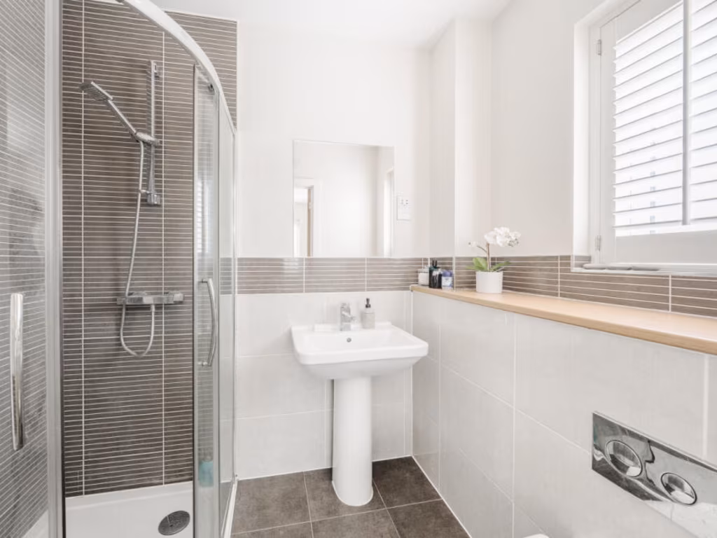
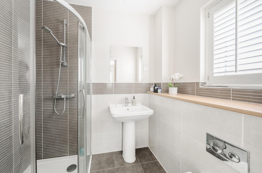
- Bathrooms: 3
- Property Type: undefined
- Property SubType: undefined
Brochure Descriptions
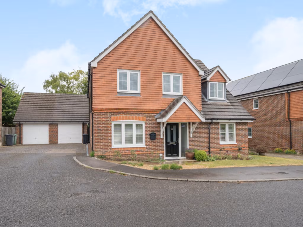
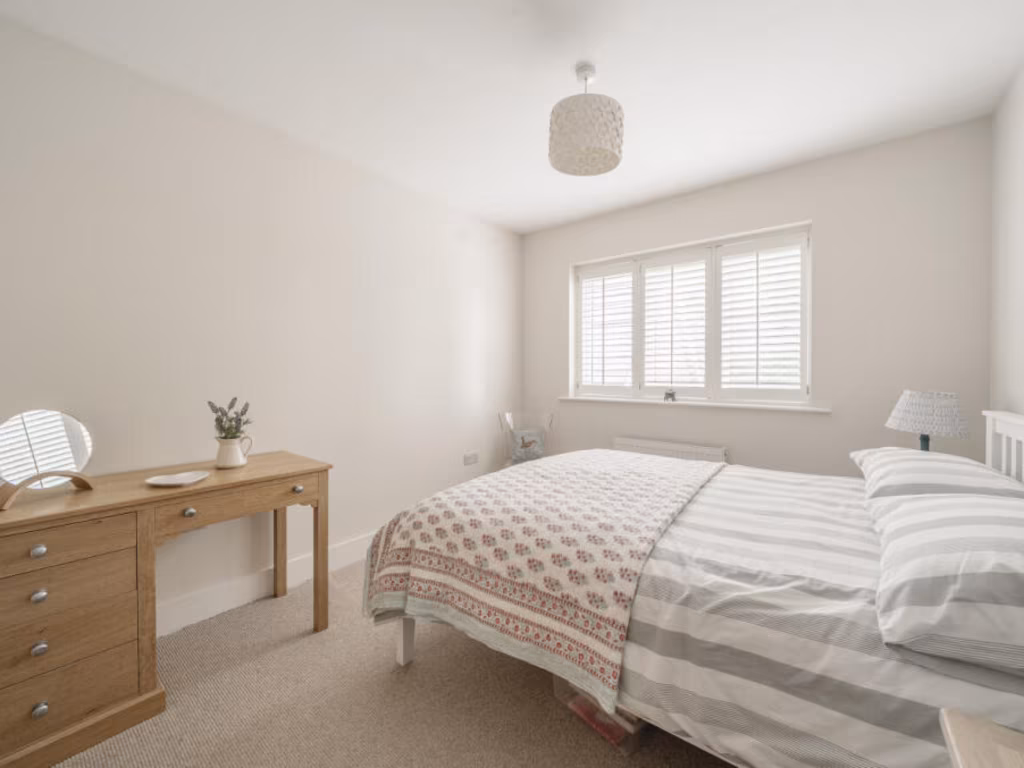
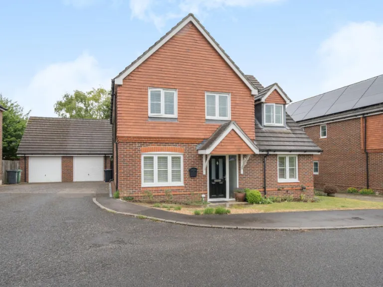
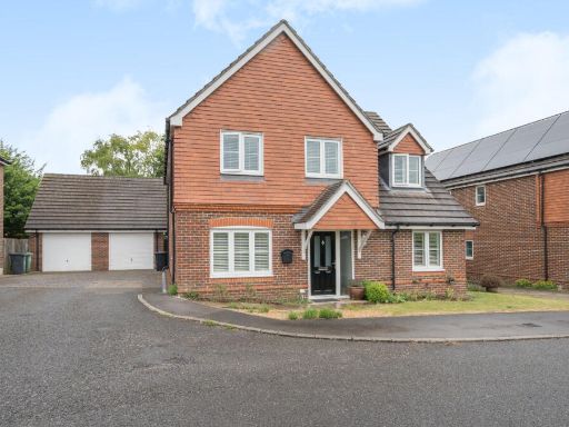
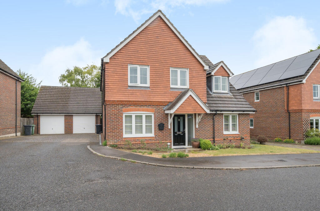
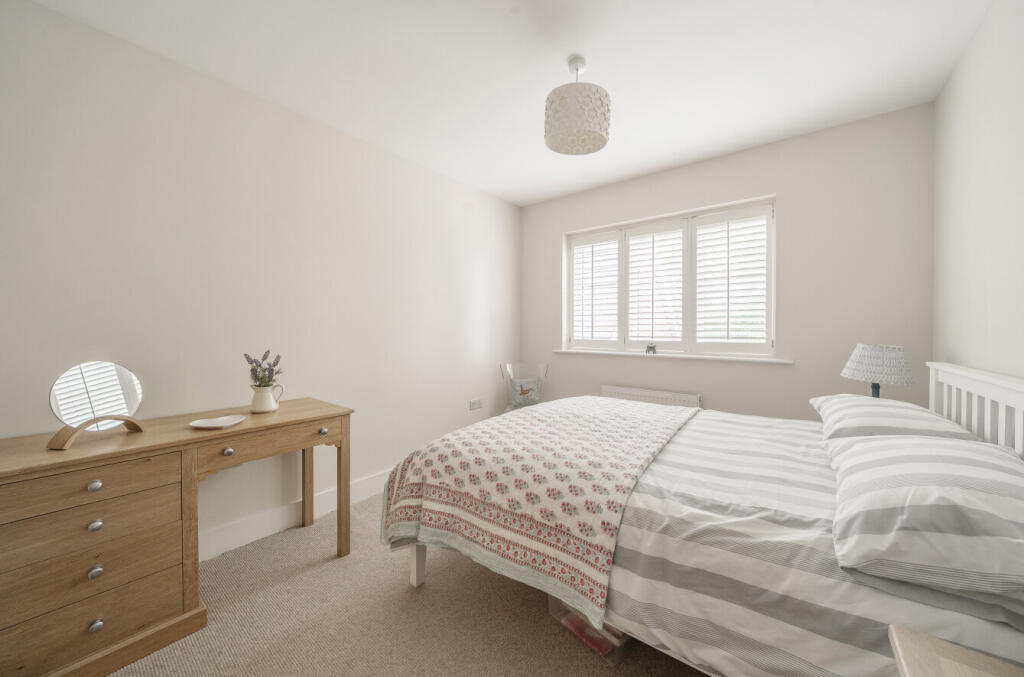
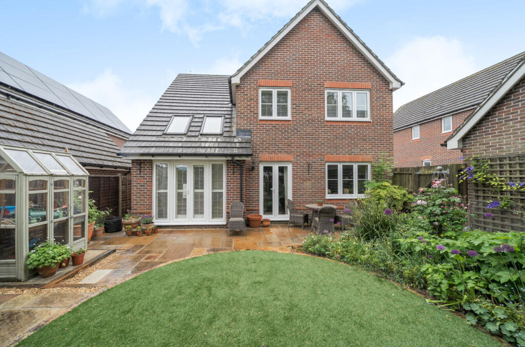
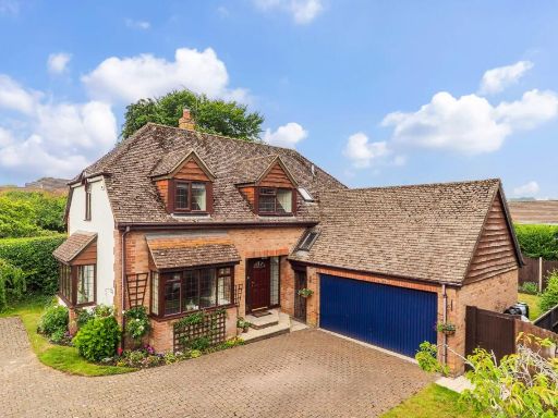
- This detached house is a prime example of modern residential living in a tranquil neighborhood. The property boasts a well-maintained brick exterior under a pitched roof enhanced by solar panels. The front garden is modest, bordered by shrubs and paving that leads to the double garage—a notable convenience for parking and storage. With ample driveway space, it offers additional parking for residents and guests. The property is surrounded by similar well-established homes, providing a sense of community. The large windows and dormers ensure an abundance of natural light to the interior. The overall property size is average, suitable for a typical family.
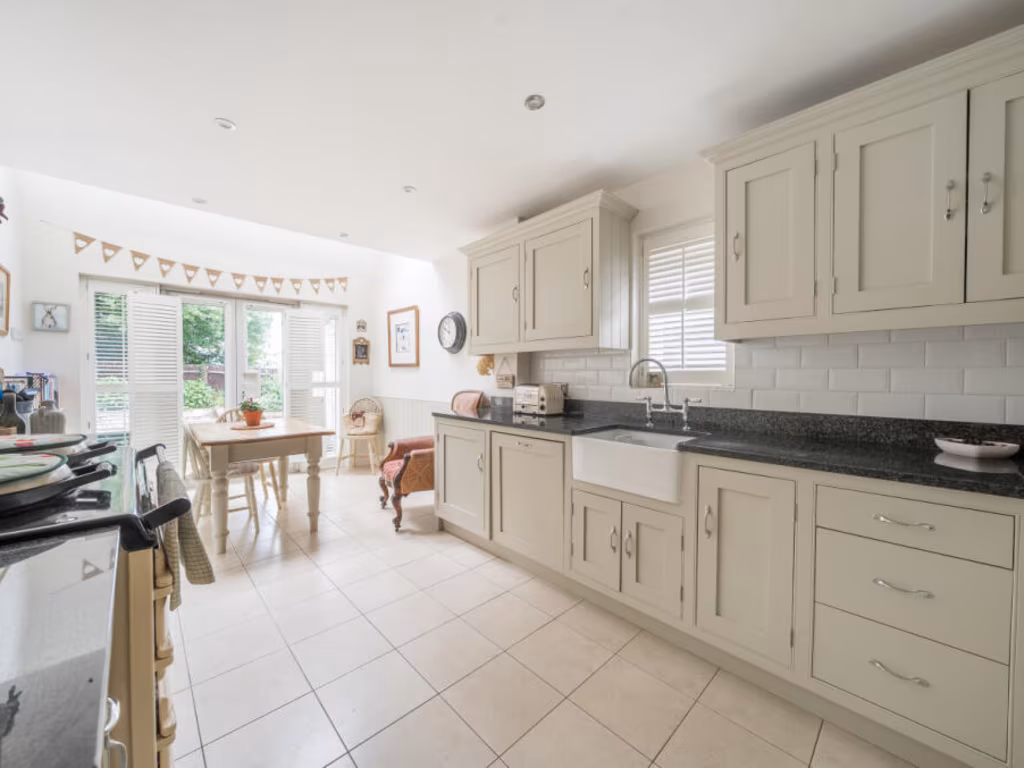
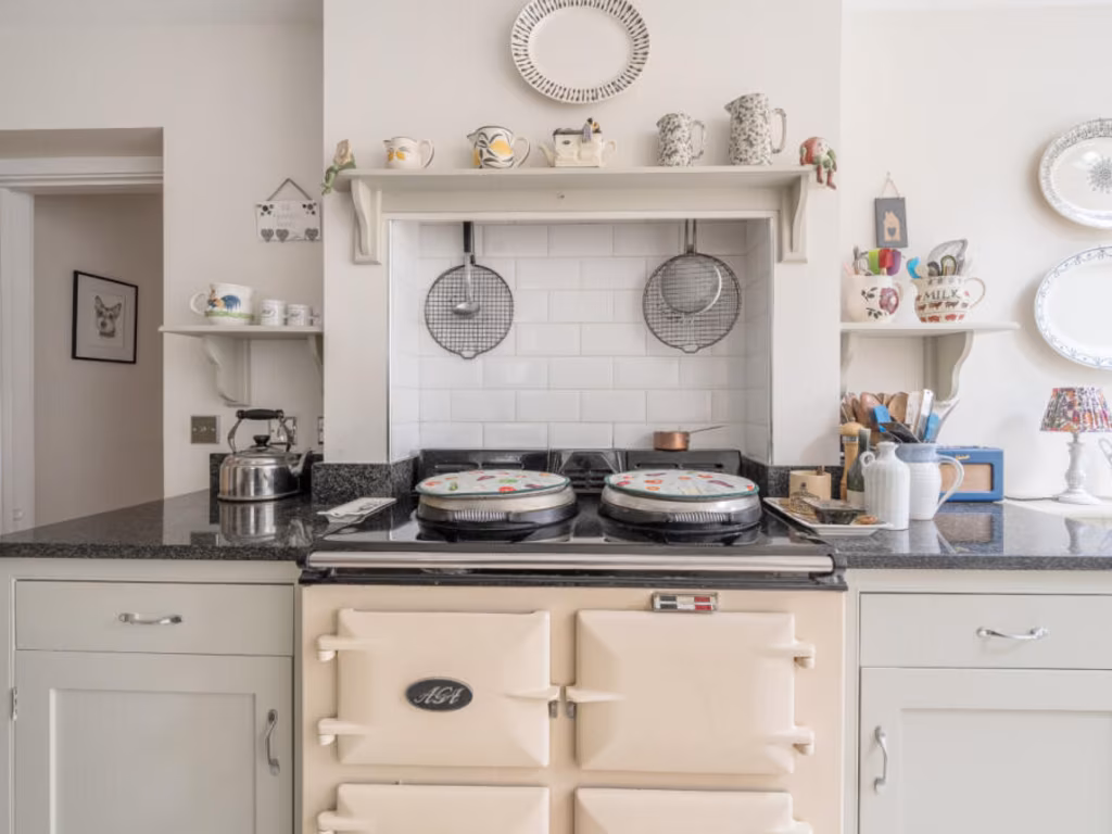
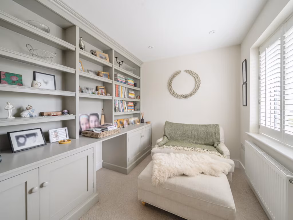
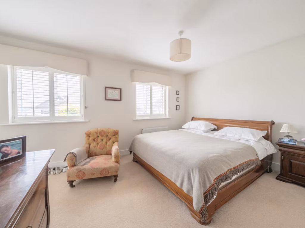
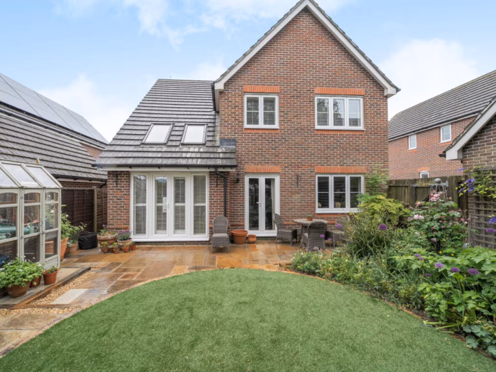
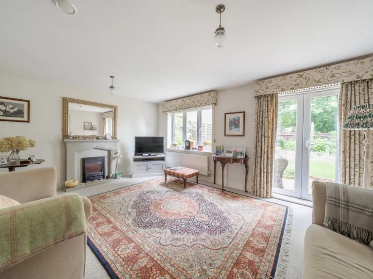
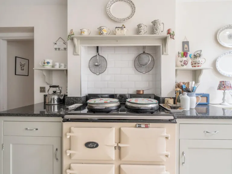
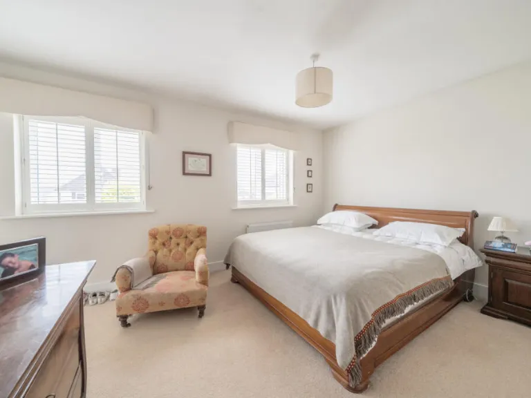
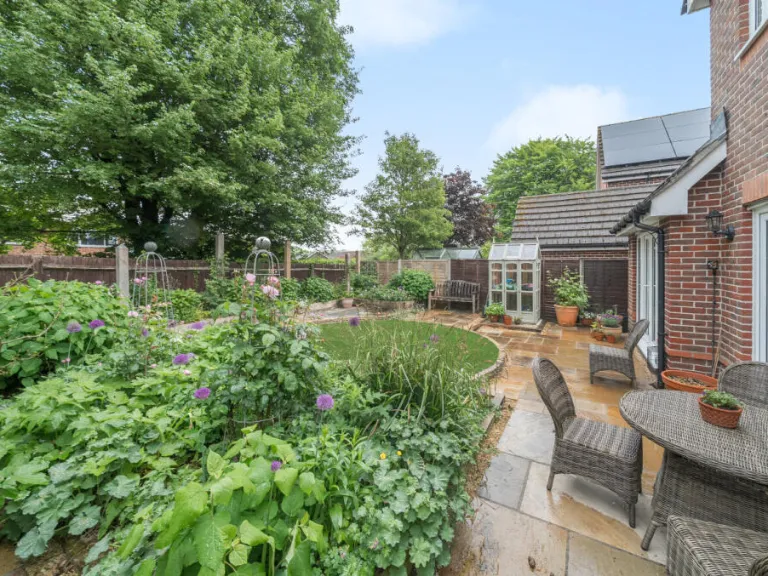
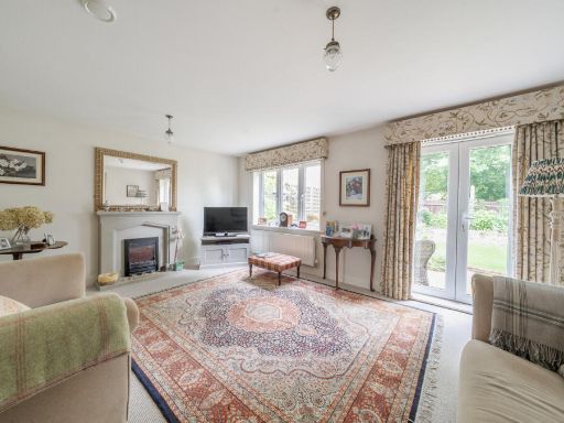
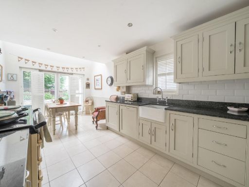
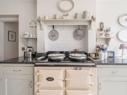
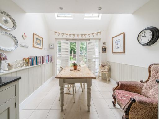
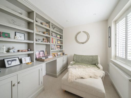
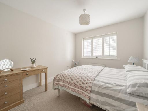
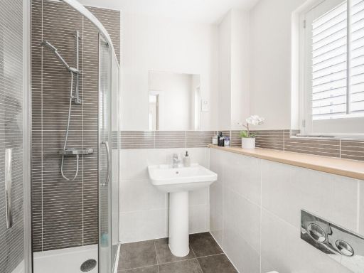
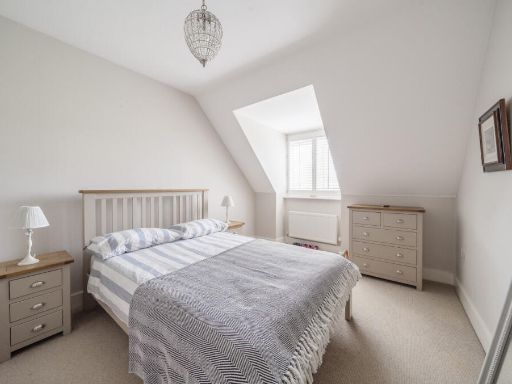
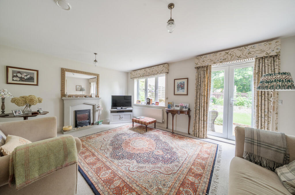
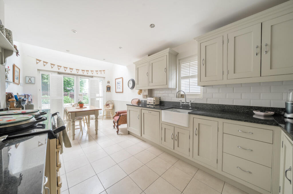
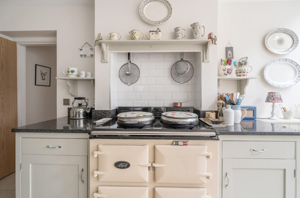
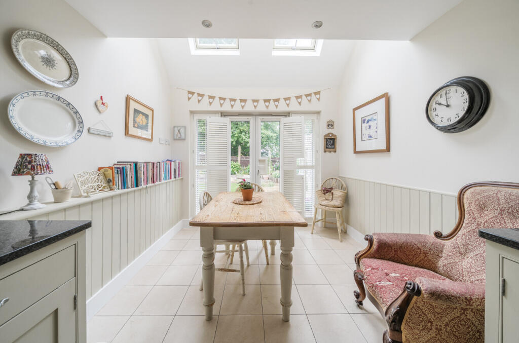
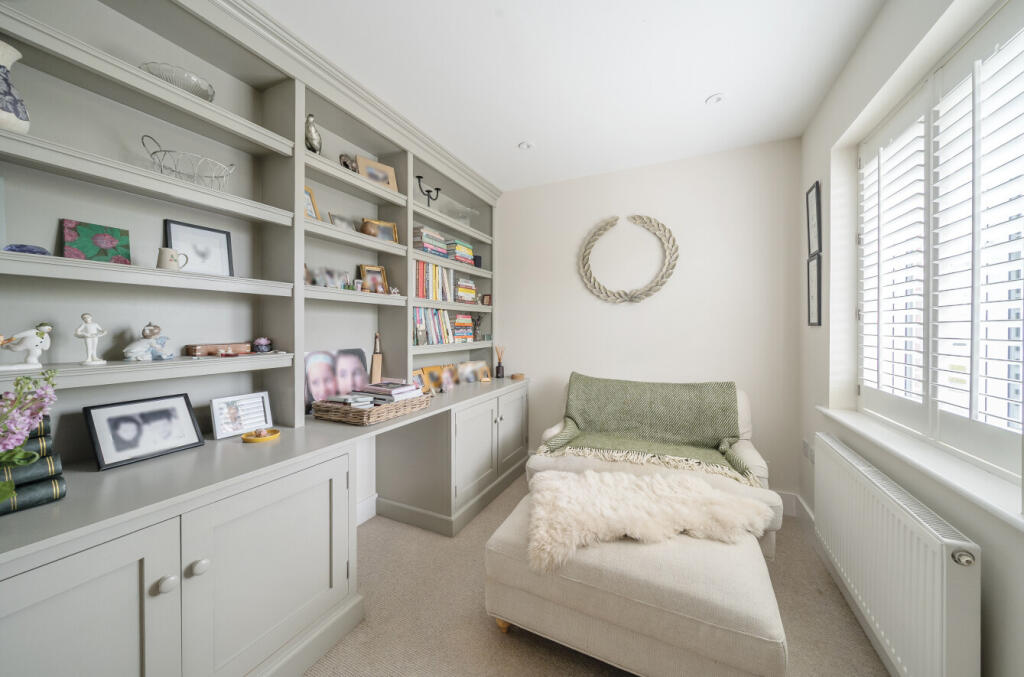
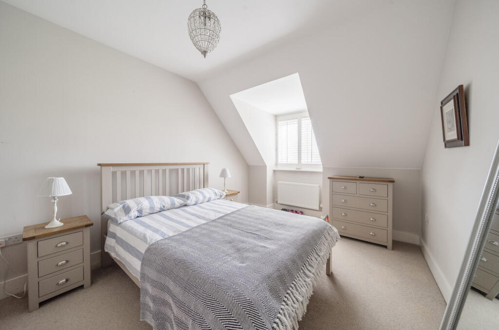
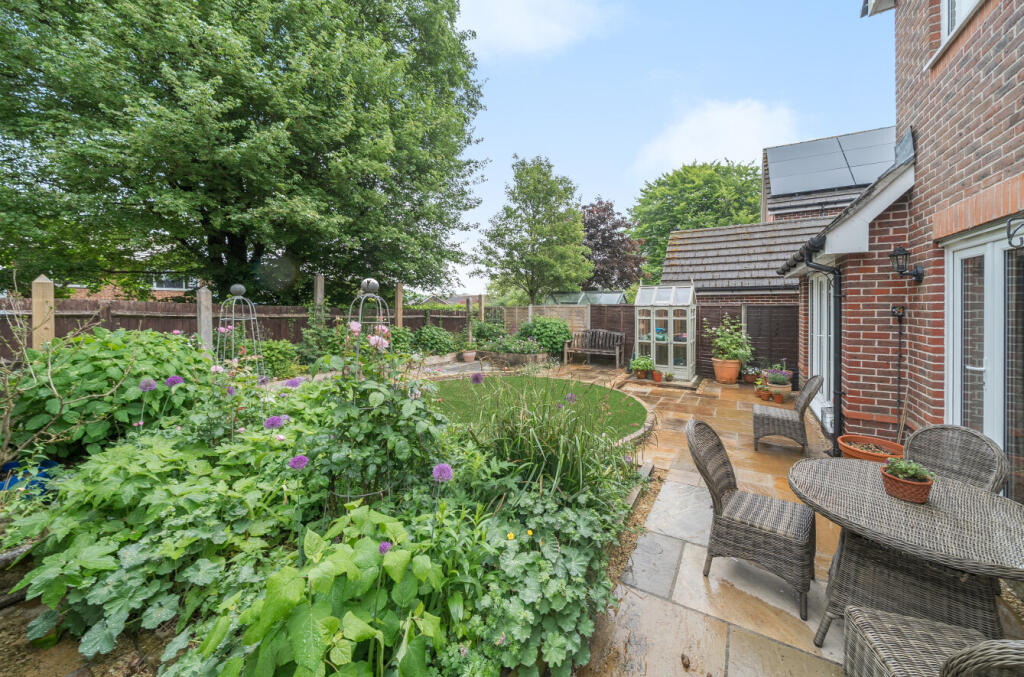
- This property features a charming country-style house situated on a quiet residential road, offering privacy with its private landscaped rear garden. The garden is lush with mature trees and flowering shrubs, providing an excellent outdoor space for relaxation and entertainment. This four-bedroom property includes two en suite shower rooms and a spacious family bathroom. The interiors boast a large sitting room, formal dining room, and a traditional country-style kitchen equipped with an AGA cooker. The additional snug or office room and utility room offer functionality justifying a spacious indoor setup. Ample driveway parking and a garage complete the practical needs of this house. The views are limited to the enclosed garden, which appears small to average in size, making it ideal for low-maintenance needs.
Image Descriptions
- detached house contemporary
- living room contemporary
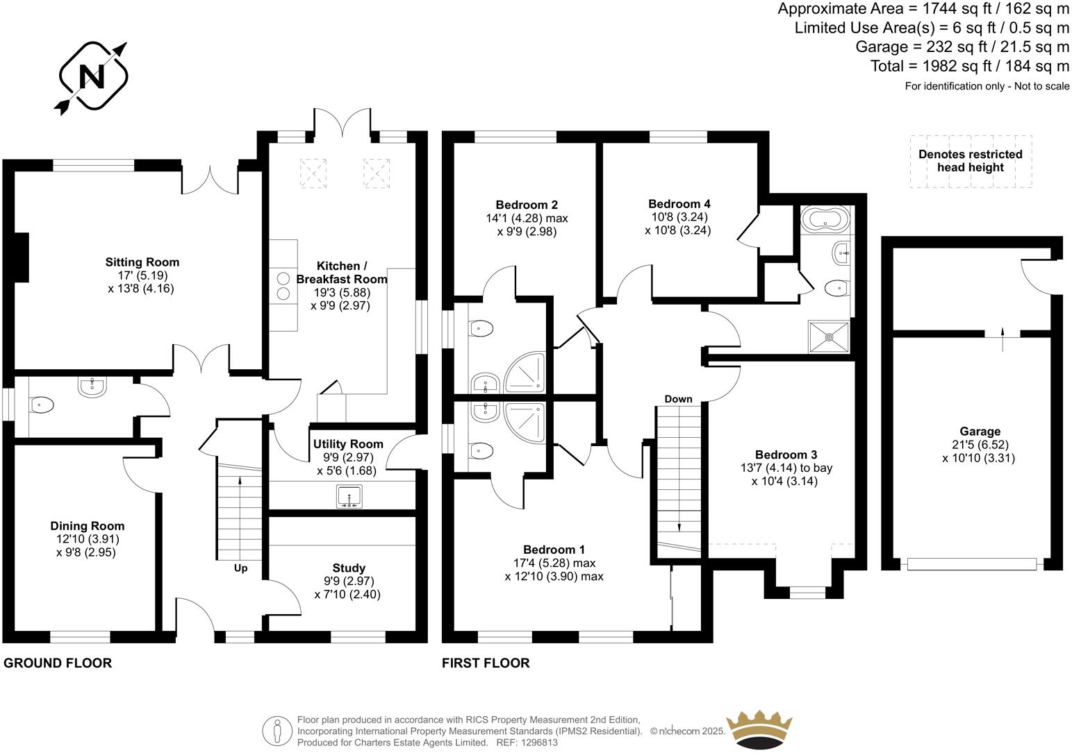
Rooms
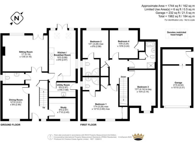
- Sitting Room: Large
- Dining Room: Average
- Kitchen / Breakfast Room: Large
- Utility Room: Small
- Study: Small
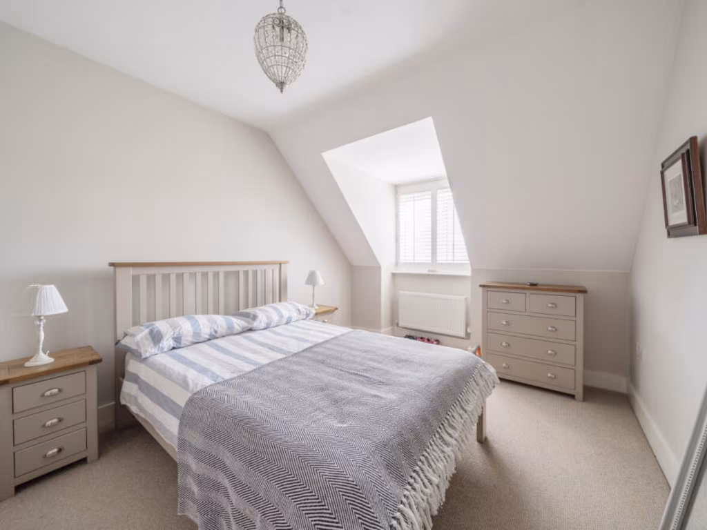
- Bedroom 1: Large
- Bedroom 2: Average
- Bedroom 3: Average
- Bedroom 4: Average
- Garage: Large
Textual Property Features
Detected Visual Features
- detached house
- contemporary
- modern roof
- dormer windows
- double garage
- corner lot
- living room
- fireplace
- large windows
- garden view
- natural light
EPC Details
- Fully double glazed
- Cavity wall, filled cavity
- Boiler and radiators, mains gas
- Low energy lighting in all fixed outlets
- Suspended, insulated (assumed)
Nearby Schools
- Alton Infant School
- Amery Hill School
- Ropley CofE Primary School
- Anstey Junior School
- Wootey Junior School
- Andrews' Endowed Church of England Primary School
- Binsted Church of England Primary School
- Long Sutton Church of England Primary School
- Chawton Church of England Primary School
- The Butts Primary School
- Lord Wandsworth College
- Four Marks Church of England Primary School
- Selborne Church of England Primary School
- Saint Lawrence Church of England Primary School
- Eggar's School
- Wootey Infant School
- Medstead Church of England Primary School
- St Mary's Bentworth Church of England Primary School
Nearest Bars And Restaurants
- Id: 355512196
- Tags:
- Addr:
- City: Alton
- Country: GB
- Housenumber: 89
- Postcode: GU34 1SS
- Street: Draymans Way
- Amenity: pub
- Beer_garden: yes
- Brand: Wetherspoon
- Brand:wikidata: Q6109362
- Brand:wikipedia: en:Wetherspoons
- Building: yes
- Contact:
- Website: https://www.jdwetherspoon.com/pubs/all-pubs/england/hampshire/the-ivy-house-alton
- Fhrs:
- Food: yes
- Internet_access: wlan
- Name: The Ivy House
- Outdoor_seating: yes
- Phone: +44 1420 549011
- Real_ale: yes
- Real_cider: yes
- Smoking: separated
- Wheelchair: limited
- Wikidata: Q88916036
- TagsNormalized:
- Lat: 51.1464419
- Lon: -0.977947
- FullGeoHash: gcp6cwzvs5vf
- PartitionGeoHash: gcp6
- Images:
- FoodStandards:
- Id: 719213
- FHRSID: 719213
- LocalAuthorityBusinessID: 29546
- BusinessName: Ivy House
- BusinessType: Pub/bar/nightclub
- BusinessTypeID: 7843
- AddressLine1: The Ivy House, Draymans Way, Alton, GU34 1SS
- AddressLine2: null
- AddressLine3: null
- AddressLine4: null
- PostCode: GU34 1SS
- RatingValue: 5
- RatingKey: fhrs_5_en-GB
- RatingDate: 2021-06-02
- LocalAuthorityCode: 132
- LocalAuthorityName: East Hampshire
- LocalAuthorityWebSite: http://www.easthants.gov.uk/
- LocalAuthorityEmailAddress: ehealth@easthants.gov.uk
- Scores:
- Hygiene: 0
- Structural: 5
- ConfidenceInManagement: 0
- NewRatingPending: false
- Geocode:
- Longitude: -0.97519900000000
- Latitude: 51.14699500000000
- Distance: 658.4
,- Id: 355520427
- Tags:
- Accommodation: yes
- Addr:
- City: Alton
- Housenumber: 96-98
- Postcode: GU34 1EN
- Street: High Street
- Amenity: pub
- Building: yes
- Building:colour: white
- Building:levels: 2
- Building:material: plaster
- Check_date: 2022-07-17
- Fhrs:
- Name: The White Horse
- Real_ale: yes
- Real_cider: yes
- Source:
- Addr: FSA Food Hygiene Rating System open data
- Wikidata: Q26589009
- TagsNormalized:
- Lat: 51.1469214
- Lon: -0.978167
- FullGeoHash: gcp6cxp8rj1y
- PartitionGeoHash: gcp6
- Images:
- FoodStandards:
- Id: 991689
- FHRSID: 991689
- LocalAuthorityBusinessID: 34936
- BusinessName: White Horse
- BusinessType: Pub/bar/nightclub
- BusinessTypeID: 7843
- AddressLine1: White Horse, 96-98 High Street, Alton, GU34 1EN
- AddressLine2: null
- AddressLine3: null
- AddressLine4: null
- PostCode: GU34 1EN
- RatingValue: 5
- RatingKey: fhrs_5_en-GB
- RatingDate: 2022-05-06
- LocalAuthorityCode: 132
- LocalAuthorityName: East Hampshire
- LocalAuthorityWebSite: http://www.easthants.gov.uk/
- LocalAuthorityEmailAddress: ehealth@easthants.gov.uk
- Scores:
- Hygiene: 0
- Structural: 5
- ConfidenceInManagement: 0
- NewRatingPending: false
- Geocode:
- Longitude: -0.97815400000000
- Latitude: 51.14718400000000
- Distance: 642.5
,- Id: 488574591
- Tags:
- Addr:
- City: Alton
- Housenumber: 2
- Postcode: GU34 1NG
- Street: Mount Pleasant Road
- Amenity: pub
- Building: yes
- Building:colour: white
- Building:levels: 2
- Fhrs:
- Name: The Hop Poles
- Roof:
- Source:
- Addr: FSA Food Hygiene Rating System open data
- Wikidata: Q26623241
- TagsNormalized:
- Lat: 51.1461668
- Lon: -0.9785766
- FullGeoHash: gcp6cwzkj883
- PartitionGeoHash: gcp6
- Images:
- FoodStandards: null
- Distance: 617
,- Id: 486255062
- Tags:
- Addr:
- City: Alton
- Housenumber: 106
- Postcode: GU34 1EN
- Street: High Street
- Amenity: fast_food
- Building: retail
- Building:levels: 2
- Cuisine: chinese
- Fhrs:
- Name: Man's Chinese Takeaway
- Roof:
- Source:
- Addr:
- Postcode: FSA Food Hygiene Rating System open data
- Takeaway: only
- TagsNormalized:
- fast food
- food
- retail
- chinese
- takeaway
- Lat: 51.1465723
- Lon: -0.9786693
- FullGeoHash: gcp6cwzq7k57
- PartitionGeoHash: gcp6
- Images:
- FoodStandards:
- Id: 91395
- FHRSID: 91395
- LocalAuthorityBusinessID: 25226
- BusinessName: Man's Chinese Takeaway
- BusinessType: Takeaway/sandwich shop
- BusinessTypeID: 7844
- AddressLine1: Man Chinese Restaurant, 106 High Street, Alton, GU34 1EN
- AddressLine2: null
- AddressLine3: null
- AddressLine4: null
- PostCode: GU34 1EN
- RatingValue: 5
- RatingKey: fhrs_5_en-GB
- RatingDate: 2021-03-16
- LocalAuthorityCode: 132
- LocalAuthorityName: East Hampshire
- LocalAuthorityWebSite: http://www.easthants.gov.uk/
- LocalAuthorityEmailAddress: ehealth@easthants.gov.uk
- Scores:
- Hygiene: 5
- Structural: 5
- ConfidenceInManagement: 5
- NewRatingPending: false
- Geocode:
- Longitude: -0.97815400000000
- Latitude: 51.14718400000000
- Distance: 607.5
,- Id: 488130860
- Tags:
- Addr:
- City: Alton
- Postcode: GU34 1LH
- Street: Butts Road
- Amenity: pub
- Building: retail
- Building:levels: 2
- Fhrs:
- Food: yes
- Name: The George
- Real_ale: yes
- Roof:
- Source:
- Addr: FSA Food Hygiene Rating System open data
- TagsNormalized:
- Lat: 51.146136
- Lon: -0.97888
- FullGeoHash: gcp6cwz5y6y1
- PartitionGeoHash: gcp6
- Images:
- FoodStandards: null
- Distance: 596.3
}
Nearest General Shops
- Id: 486255055
- Tags:
- Addr:
- City: Alton
- Housenumber: 110
- Postcode: GU34 1EN
- Street: High Street
- Building: retail
- Building:colour: grey
- Building:levels: 2
- Building:material: plaster
- Name: Alton Sports
- Roof:
- Shop: sports
- Source:
- TagsNormalized:
- Lat: 51.1464902
- Lon: -0.9788238
- FullGeoHash: gcp6cwzjzub4
- PartitionGeoHash: gcp6
- Images:
- FoodStandards: null
- Distance: 597.1
,- Id: 486255058
- Tags:
- Addr:
- City: Alton
- Country: GB
- Housenumber: 112
- Postcode: GU34 1EN
- Street: High Street
- Building: retail
- Building:levels: 2
- Name: 1st Gear Cycles
- Roof:
- Shop: bicycle
- TagsNormalized:
- Lat: 51.146459
- Lon: -0.978898
- FullGeoHash: gcp6cwzjwp08
- PartitionGeoHash: gcp6
- Images:
- FoodStandards: null
- Distance: 592.1
,- Id: 488574644
- Tags:
- Building: retail
- Building:levels: 2
- Building:material: brick
- Name: DMK Hair Design
- Phone: +44 1420 85001
- Roof:
- Colour: dark_grey
- Material: roof_tiles
- Shop: hairdresser
- TagsNormalized:
- Lat: 51.1449631
- Lon: -0.9809284
- FullGeoHash: gcp6cwttn8nu
- PartitionGeoHash: gcp6
- Images:
- FoodStandards: null
- Distance: 491.2
}
Nearest Religious buildings
- Id: 314501233
- Tags:
- Addr:
- City: Alton
- Postcode: GU34 1AU
- Street: Draymans Way
- Amenity: place_of_worship
- Building: church
- Building:levels: 1
- Building:material: brick
- Denomination: methodist
- Fhrs:
- Name: Alton Methodist Church
- Religion: christian
- Source: Bing;survey
- Source:addr: FSA Food Hygiene Rating System open data
- Wikidata: Q26386523
- TagsNormalized:
- place of worship
- church
- methodist
- christian
- Lat: 51.1466273
- Lon: -0.9773475
- FullGeoHash: gcp6cybqdnku
- PartitionGeoHash: gcp6
- Images:
- FoodStandards:
- Id: 86042
- FHRSID: 86042
- LocalAuthorityBusinessID: 2186
- BusinessName: Alton Methodist Church
- BusinessType: Other catering premises
- BusinessTypeID: 7841
- AddressLine1: Alton Methodist Church, Draymans Way, Alton, GU34 1AU
- AddressLine2: null
- AddressLine3: null
- AddressLine4: null
- PostCode: GU34 1AU
- RatingValue: 5
- RatingKey: fhrs_5_en-GB
- RatingDate: 2021-12-14
- LocalAuthorityCode: 132
- LocalAuthorityName: East Hampshire
- LocalAuthorityWebSite: http://www.easthants.gov.uk/
- LocalAuthorityEmailAddress: ehealth@easthants.gov.uk
- Scores:
- Hygiene: 0
- Structural: 0
- ConfidenceInManagement: 5
- NewRatingPending: false
- Geocode:
- Longitude: -0.97554200000000
- Latitude: 51.14765500000000
- Distance: 699.5
,- Id: 360735098
- Tags:
- Amenity: grave_yard
- Denomination: anglican
- Landuse: religious
- Religion: christian
- TagsNormalized:
- grave yard
- anglican
- religious
- christian
- Lat: 51.1454976
- Lon: -0.9803262
- FullGeoHash: gcp6cwy0hezc
- PartitionGeoHash: gcp6
- Images:
- FoodStandards: null
- Distance: 510.7
,- Id: 360735097
- Tags:
- Amenity: place_of_worship
- Building: church
- Building:material: stone
- Denomination: anglican
- Name: All Saints Church
- Religion: christian
- Roof:
- Source: Bing;photograph
- Wikidata: Q4729305
- Wikipedia: en:All Saints' Church, Alton
- TagsNormalized:
- place of worship
- church
- anglican
- christian
- Lat: 51.1454733
- Lon: -0.9803483
- FullGeoHash: gcp6cwwpupr2
- PartitionGeoHash: gcp6
- Images:
- FoodStandards: null
- Distance: 510
}
Nearest Airports
- Id: 100647893
- Tags:
- Aerodrome: international
- Aerodrome:type: public
- Aeroway: aerodrome
- Contact:
- Vhf:
- Approach: 120.225 MHz
- Tower: 118.2 MHz
- Ele: 44ft
- Iata: SOU
- Icao: EGHI
- Is_in: Hampshire, England,UK
- Name: Southampton Airport
- Operator: Southampton International Airport Limited
- Source: Bing;Gagravarr_Airports
- Wikidata: Q8988
- Wikipedia: en:Southampton Airport
- TagsNormalized:
- airport
- international airport
- Lat: 50.9513872
- Lon: -1.3516684
- FullGeoHash: gcp1c5rtrffz
- PartitionGeoHash: gcp1
- Images:
- FoodStandards: null
- Distance: 33471.5
}
Nearest Leisure Facilities
- Id: 698326670
- Tags:
- TagsNormalized:
- swimming
- swimming pool
- pool
- leisure
- Lat: 51.1447496
- Lon: -0.9887093
- FullGeoHash: gcp6cw85c2kg
- PartitionGeoHash: gcp6
- Images:
- FoodStandards: null
- Distance: 240.3
,- Id: 698326671
- Tags:
- TagsNormalized:
- swimming
- swimming pool
- pool
- leisure
- Lat: 51.1449522
- Lon: -0.9882791
- FullGeoHash: gcp6cw8kgqje
- PartitionGeoHash: gcp6
- Images:
- FoodStandards: null
- Distance: 208.8
,- Id: 729387243
- Tags:
- TagsNormalized:
- swimming
- swimming pool
- pool
- leisure
- Lat: 51.1467202
- Lon: -0.9847313
- FullGeoHash: gcp6cwfznpen
- PartitionGeoHash: gcp6
- Images:
- FoodStandards: null
- Distance: 184.3
,- Id: 719671770
- Tags:
- TagsNormalized:
- swimming
- swimming pool
- pool
- leisure
- Lat: 51.1459628
- Lon: -0.9885913
- FullGeoHash: gcp6cwb4u4sb
- PartitionGeoHash: gcp6
- Images:
- FoodStandards: null
- Distance: 121.3
,- Id: 719671800
- Tags:
- TagsNormalized:
- swimming
- swimming pool
- pool
- leisure
- Lat: 51.1460138
- Lon: -0.9866832
- FullGeoHash: gcp6cwce0s58
- PartitionGeoHash: gcp6
- Images:
- FoodStandards: null
- Distance: 94.2
}
Nearest Tourist attractions
- Id: 4906724737
- Tags:
- Check_date: 2022-07-17
- Name: O'Connors
- Tourism: guest_house
- TagsNormalized:
- Lat: 51.1505276
- Lon: -0.9732999
- FullGeoHash: gcp6czem2mqy
- PartitionGeoHash: gcp6
- Images:
- FoodStandards: null
- Distance: 1068.1
,- Id: 314318637
- Tags:
- Addr:
- City: Alton
- Postcode: GU34 1BA
- Street: High Street
- Building: yes
- Building:levels: 2
- Building:material: brick
- Check_date: 2022-07-17
- Fhrs:
- Name: Curtis Museum
- Roof:
- Source: Bing;survey
- Source:addr: FSA Food Hygiene Rating System open data
- Tourism: museum
- Wikidata: Q5195840
- Wikipedia: en:Curtis Museum
- TagsNormalized:
- Lat: 51.1498861
- Lon: -0.9734735
- FullGeoHash: gcp6cze1smve
- PartitionGeoHash: gcp6
- Images:
- FoodStandards:
- Id: 349011
- FHRSID: 349011
- LocalAuthorityBusinessID: 22493
- BusinessName: Curtis Museum
- BusinessType: Retailers - other
- BusinessTypeID: 4613
- AddressLine1: Curtis Museum, High Street, Alton, GU34 1BA
- AddressLine2: null
- AddressLine3: null
- AddressLine4: null
- PostCode: GU34 1BA
- RatingValue: Exempt
- RatingKey: fhrs_exempt_en-GB
- RatingDate: 2018-09-25
- LocalAuthorityCode: 132
- LocalAuthorityName: East Hampshire
- LocalAuthorityWebSite: http://www.easthants.gov.uk/
- LocalAuthorityEmailAddress: ehealth@easthants.gov.uk
- Scores:
- Hygiene: null
- Structural: null
- ConfidenceInManagement: null
- NewRatingPending: false
- Geocode:
- Longitude: -0.97364600000000
- Latitude: 51.14998600000000
- Distance: 1030.7
,- Id: 380267319
- Tags:
- Addr:
- City: Alton
- Housenumber: 10-12
- Postcode: GU34 2BW
- Street: Church Street
- Building: yes
- Check_date: 2022-07-17
- Fee: no
- Fhrs:
- Name: The Allen Gallery
- Note: Ceramics collection, regular art exhibitions, tea room, garden.
- Opening_hours: Tu-Su 10:30-16:00
- Operator: Hampshire Cultural Trust
- Source:
- Addr:
- Housenumber: FSA Food Hygiene Rating System data
- Tourism: museum
- Website: http://hampshireculturaltrust.org.uk/allen-gallery
- Wikidata: Q103160541
- TagsNormalized:
- Lat: 51.1503723
- Lon: -0.9744749
- FullGeoHash: gcp6czdkt06z
- PartitionGeoHash: gcp6
- Images:
- FoodStandards:
- Id: 570309
- FHRSID: 570309
- LocalAuthorityBusinessID: 27548
- BusinessName: Allen Gallery
- BusinessType: Restaurant/Cafe/Canteen
- BusinessTypeID: 1
- AddressLine1: Allen Gallery, 10-12 Church Street, Alton, GU34 2BW
- AddressLine2: null
- AddressLine3: null
- AddressLine4: null
- PostCode: GU34 2BW
- RatingValue: 4
- RatingKey: fhrs_4_en-GB
- RatingDate: 2020-04-17
- LocalAuthorityCode: 132
- LocalAuthorityName: East Hampshire
- LocalAuthorityWebSite: http://www.easthants.gov.uk/
- LocalAuthorityEmailAddress: ehealth@easthants.gov.uk
- Scores:
- Hygiene: 0
- Structural: 10
- ConfidenceInManagement: 5
- NewRatingPending: false
- Geocode:
- Longitude: -0.97489400000000
- Latitude: 51.15045500000000
- Distance: 986.2
}
Nearest Train stations
- Id: 6010627227
- Tags:
- Name: Liss
- Naptan:
- Network: National Rail
- Operator: South West Trains
- Public_transport: station
- Railway: station
- Ref:
- Wikidata: Q1884678
- Wikipedia: en:Liss railway station
- TagsNormalized:
- Lat: 51.0439274
- Lon: -0.8926226
- FullGeoHash: gcp67sq02msr
- PartitionGeoHash: gcp6
- Images:
- FoodStandards: null
- Distance: 13209.2
,- Id: 26472788
- Tags:
- Name: Ropley
- Naptan:
- Operator: The Mid Hants Railway 'Watercress Line'
- Public_transport: station
- Railway: station
- Usage: tourism
- Website: https://www.watercressline.co.uk/
- Wikidata: Q7366762
- TagsNormalized:
- Lat: 51.0874683
- Lon: -1.1025399
- FullGeoHash: gcp4wujnhfqd
- PartitionGeoHash: gcp4
- Images:
- FoodStandards: null
- Distance: 10395.2
,- Id: 2458373284
- Tags:
- Name: Bentley
- Name:lt: Bentlis
- Naptan:
- Network: National Rail
- Operator: South Western Railway
- Public_transport: station
- Railway: station
- Ref:
- Wheelchair: yes
- Wikidata: Q1883564
- Wikipedia: en:Bentley railway station (Hampshire)
- TagsNormalized:
- Lat: 51.1812254
- Lon: -0.8681985
- FullGeoHash: gcp7hjrb1xbm
- PartitionGeoHash: gcp7
- Images:
- FoodStandards: null
- Distance: 9152
,- Id: 47008811
- Tags:
- Name: Medstead and Four Marks
- Naptan:
- Operator: Watercress Line
- Public_transport: station
- Railway: station
- Usage: tourism
- Wheelchair: yes
- Wikidata: Q6807304
- TagsNormalized:
- Lat: 51.1134108
- Lon: -1.0457926
- FullGeoHash: gcp6b0ympq2e
- PartitionGeoHash: gcp6
- Images:
- FoodStandards: null
- Distance: 5509.5
,- Id: 2755047275
- Tags:
- Name: Alton
- Naptan:
- Network: National Rail
- Operator: Southwestern Railway
- Public_transport: station
- Railway: station
- Ref:
- Source: NPE
- Wikidata: Q2694837
- Wikipedia: en:Alton railway station
- TagsNormalized:
- Lat: 51.1518972
- Lon: -0.9671299
- FullGeoHash: gcp6czzv2hz8
- PartitionGeoHash: gcp6
- Images:
- FoodStandards: null
- Distance: 1524
}
Nearest Bus stations and stops
- Id: 503401600
- Tags:
- Bus: yes
- Highway: bus_stop
- Name: Wentworth Gardens
- Naptan:
- AtcoCode: 1900HA020338
- Bearing: NE
- CommonName: Wentworth Gardens
- Crossing: Tilney Close
- Landmark: O/s No. 92
- NaptanCode: hamgmdjt
- Street: Greenfields Avenue
- Verified: no
- Public_transport: platform
- Source: naptan_import
- TagsNormalized:
- Lat: 51.1518046
- Lon: -0.9845537
- FullGeoHash: gcp6cxghf5rx
- PartitionGeoHash: gcp6
- Images:
- FoodStandards: null
- Distance: 596.4
,- Id: 503401595
- Tags:
- Bus: yes
- Highway: bus_stop
- Name: Wentworth Gardens
- Naptan:
- AtcoCode: 1900HA020337
- Bearing: SW
- CommonName: Wentworth Gardens
- Crossing: Wentworth Gardens
- NaptanCode: hamgmdjw
- Street: Greenfields Avenue
- Verified: no
- Public_transport: platform
- Source: naptan_import
- TagsNormalized:
- Lat: 51.1517321
- Lon: -0.9844838
- FullGeoHash: gcp6cxgh7vgx
- PartitionGeoHash: gcp6
- Images:
- FoodStandards: null
- Distance: 590.4
,- Id: 9563655959
- Tags:
- Bus: yes
- Highway: bus_stop
- Public_transport: platform
- TagsNormalized:
- Lat: 51.151461
- Lon: -0.9882013
- FullGeoHash: gcp6cxb6v5rw
- PartitionGeoHash: gcp6
- Images:
- FoodStandards: null
- Distance: 527.9
,- Id: 503401588
- Tags:
- Bus: yes
- Highway: bus_stop
- Name: Brandon Close
- Naptan:
- AtcoCode: 1900HA020336
- Bearing: E
- CommonName: Brandon Close
- Crossing: Brandon Close
- NaptanCode: hamgmdam
- Street: Greenfields Avenue
- Verified: no
- Public_transport: platform
- Source: naptan_import
- TagsNormalized:
- Lat: 51.1512457
- Lon: -0.9864676
- FullGeoHash: gcp6cxc9tek3
- PartitionGeoHash: gcp6
- Images:
- FoodStandards: null
- Distance: 504.8
,- Id: 7485827953
- Tags:
- Bus: yes
- Highway: bus_stop
- Name: Northdown Way
- Public_transport: platform
- TagsNormalized:
- Lat: 51.1510468
- Lon: -0.9879071
- FullGeoHash: gcp6cxb8kn5p
- PartitionGeoHash: gcp6
- Images:
- FoodStandards: null
- Distance: 480.2
}
Nearest Hotels
- Id: 497786335
- Tags:
- Addr:
- City: Alton
- Country: GB
- Postcode: GU34 1BN
- Street: High Street
- Amenity: pub
- Building: yes
- Check_date: 2022-07-17
- Fhrs:
- Name: The Crown Hotel
- Tourism: hotel
- Wikidata: Q26474615
- TagsNormalized:
- Lat: 51.1501488
- Lon: -0.9739909
- FullGeoHash: gcp6czdg0qgd
- PartitionGeoHash: gcp6
- Images:
- FoodStandards: null
- Distance: 1007.4
,- Id: 496294274
- Tags:
- Addr:
- City: Alton
- Country: GB
- Postcode: GU34 1AT
- Street: High Street
- Building: yes
- Fhrs:
- Name: The Swan
- Note: The postcode was previously tagged as GU34 1TS, though it's unclear what the source for this was, and Code-Point Open says it cannot be correct. So I've used the postcode given by FHRS Open Data.
- Operator: Greene King
- Tourism: hotel
- Website: https://www.oldenglishinns.co.uk/our-locations/the-swan-alton
- Wikidata: Q26623191
- TagsNormalized:
- Lat: 51.1486868
- Lon: -0.9752716
- FullGeoHash: gcp6cz3fdw2c
- PartitionGeoHash: gcp6
- Images:
- FoodStandards: null
- Distance: 871.4
,- Id: 356066022
- Tags:
- Addr:
- City: Alton
- Country: GB
- Housenumber: 3
- Postcode: GU34 1HD
- Street: Market Square
- Amenity: pub
- Building: yes
- Building:colour: white
- Building:levels: 2
- Building:material: plaster
- Check_date: 2022-07-17
- Fhrs:
- Name: Market Hotel
- Outdoor_seating: yes
- Roof:
- Tourism: hotel
- TagsNormalized:
- Lat: 51.1486132
- Lon: -0.9780872
- FullGeoHash: gcp6cxrf2bt6
- PartitionGeoHash: gcp6
- Images:
- FoodStandards: null
- Distance: 680.4
}
Tags
- detached house
- contemporary
- modern roof
- dormer windows
- double garage
- corner lot
- contemporary
- living room
- fireplace
- large windows
- garden view
- natural light
Local Market Stats
- Average Price/sqft: £399
- Avg Income: £57500
- Rental Yield: 3.7%
- Social Housing: 7%
- Planning Success Rate: 89%
Similar Properties
 4 bedroom detached house for sale in Duchess Close, Alton, Hampshire, GU34 — £735,000 • 4 bed • 2 bath • 1555 ft²
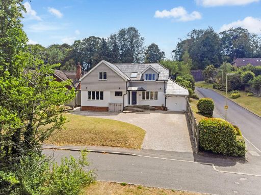 5 bedroom detached house for sale in Ashdell Road, Alton, GU34 — £975,000 • 5 bed • 2 bath • 2814 ft²
 4 bedroom detached house for sale in Goswell Square, Alton, Hampshire, GU34 — £585,000 • 4 bed • 2 bath • 1374 ft²
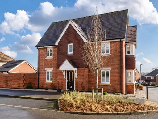 4 bedroom detached house for sale in Rowden Way, Alton, Hampshire, GU34 — £563,500 • 4 bed • 2 bath • 1182 ft²
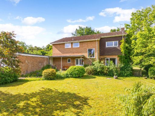 4 bedroom detached house for sale in 106 Whitedown Lane, Alton, GU34 — £795,000 • 4 bed • 2 bath • 2070 ft²
 4 bedroom detached house for sale in Hop Fields, Alton, East Hampshire, GU34 — £700,000 • 4 bed • 1 bath • 1466 ft²
Meta
- {
"@context": "https://schema.org",
"@type": "Residence",
"name": "4 bedroom detached house for sale in Knights Way, Alton, Ha…",
"description": "",
"url": "https://propertypiper.co.uk/property/cc9bfc4d-3a74-4bb8-9ddf-24c2e87c87af",
"image": "https://image-a.propertypiper.co.uk/c8560eb8-2503-4567-8052-2f3ca2139341-1024.jpeg",
"address": {
"@type": "PostalAddress",
"streetAddress": "Knights Way, ALTON, Hampshire, GU34",
"postalCode": "GU34 1PJ",
"addressLocality": "East Hampshire",
"addressRegion": "East Hampshire",
"addressCountry": "England"
},
"geo": {
"@type": "GeoCoordinates",
"latitude": 51.146741583379914,
"longitude": -0.9873736492162049
},
"numberOfRooms": 4,
"numberOfBathroomsTotal": 3,
"floorSize": {
"@type": "QuantitativeValue",
"value": 1744,
"unitCode": "FTK"
},
"offers": {
"@type": "Offer",
"price": 700000,
"priceCurrency": "GBP",
"availability": "https://schema.org/InStock"
},
"additionalProperty": [
{
"@type": "PropertyValue",
"name": "Feature",
"value": "detached house"
},
{
"@type": "PropertyValue",
"name": "Feature",
"value": "contemporary"
},
{
"@type": "PropertyValue",
"name": "Feature",
"value": "modern roof"
},
{
"@type": "PropertyValue",
"name": "Feature",
"value": "dormer windows"
},
{
"@type": "PropertyValue",
"name": "Feature",
"value": "double garage"
},
{
"@type": "PropertyValue",
"name": "Feature",
"value": "corner lot"
},
{
"@type": "PropertyValue",
"name": "Feature",
"value": "contemporary"
},
{
"@type": "PropertyValue",
"name": "Feature",
"value": "living room"
},
{
"@type": "PropertyValue",
"name": "Feature",
"value": "fireplace"
},
{
"@type": "PropertyValue",
"name": "Feature",
"value": "large windows"
},
{
"@type": "PropertyValue",
"name": "Feature",
"value": "garden view"
},
{
"@type": "PropertyValue",
"name": "Feature",
"value": "natural light"
}
]
}
High Res Floorplan Images
Compatible Floorplan Images
FloorplanImages Thumbnail