S41 0BS - 3 bedroom semidetached house for sale in Houldsworth Drive,…
View on Property Piper
3 bedroom semi-detached house for sale in Houldsworth Drive, Chesterfield, Derbyshire, S41
Property Details
- Price: £250000
- Bedrooms: 3
- Bathrooms: 2
- Property Type: undefined
- Property SubType: undefined
Brochure Descriptions
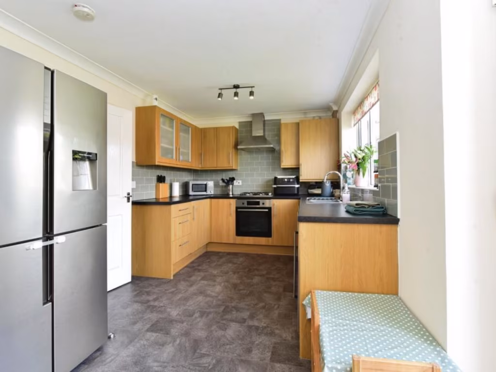
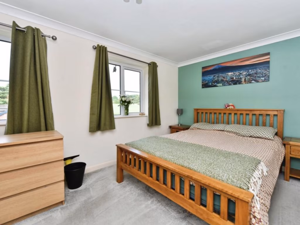
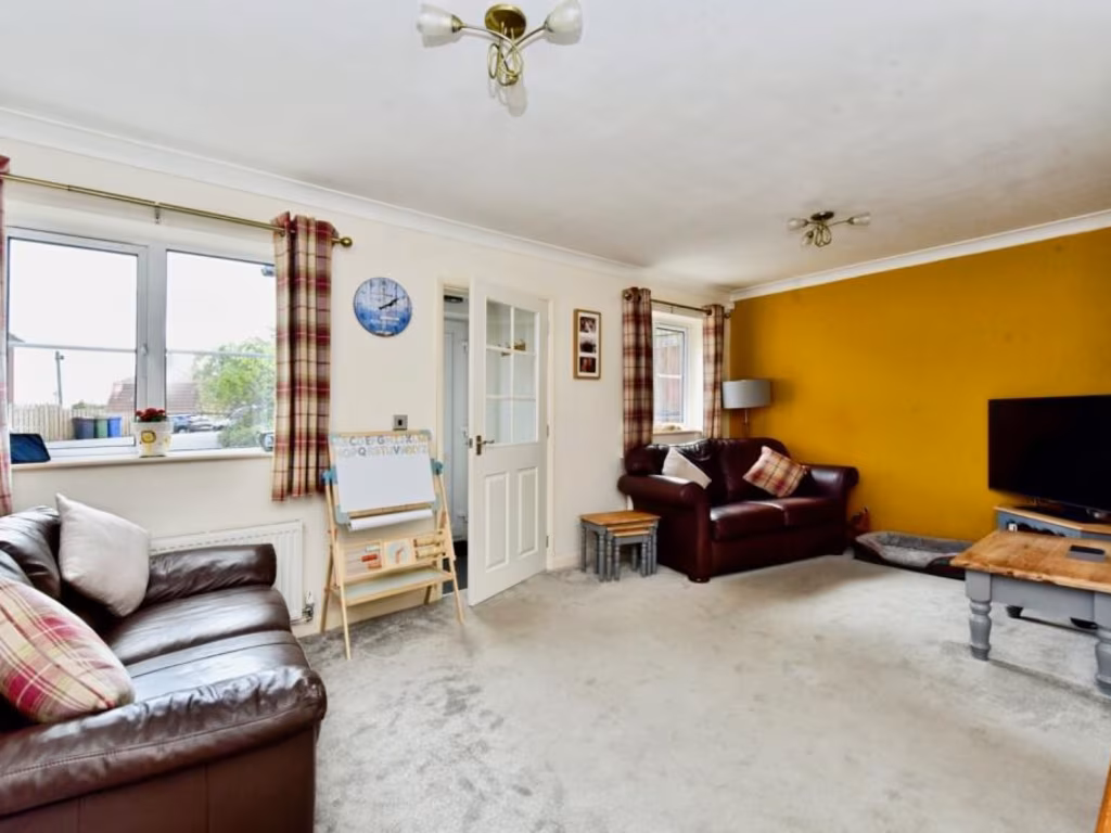
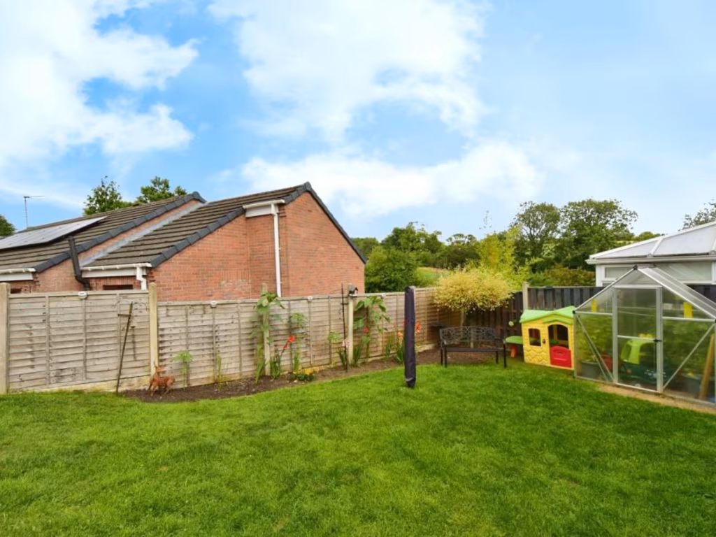
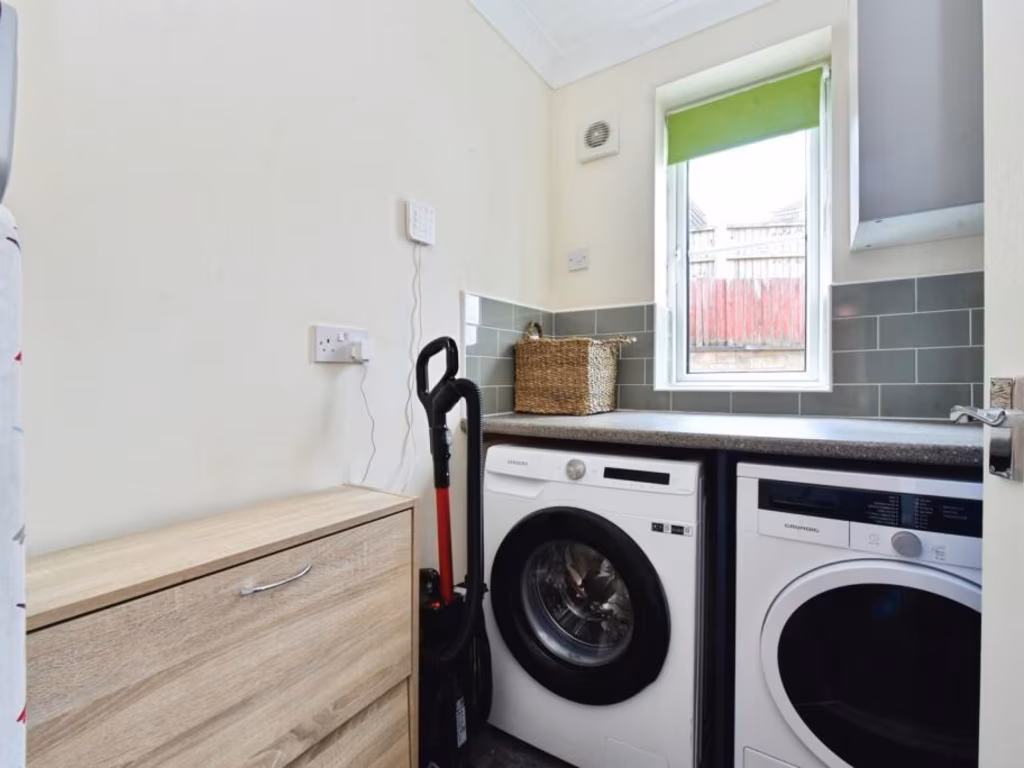
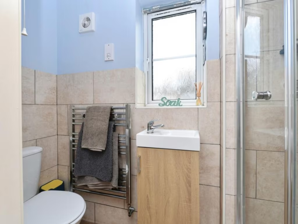
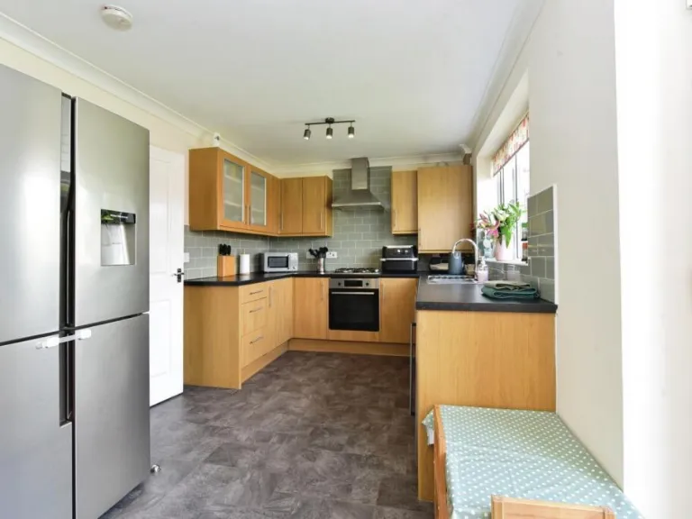
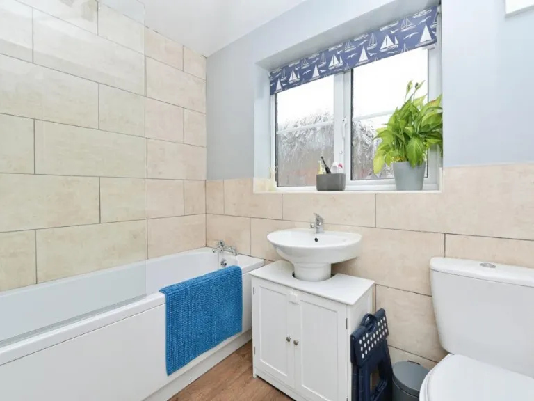
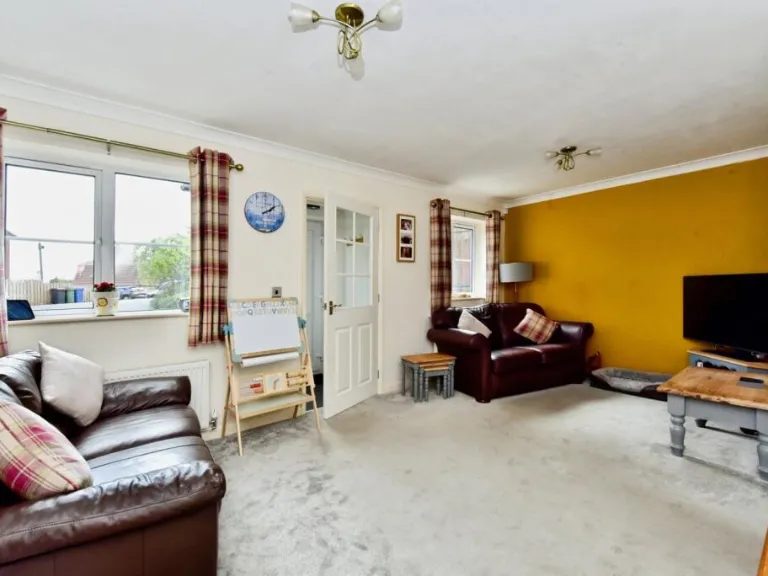
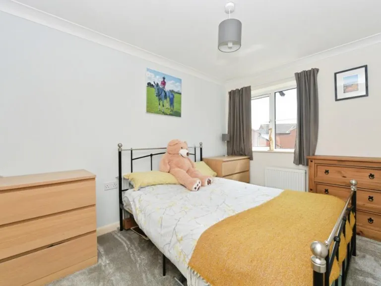
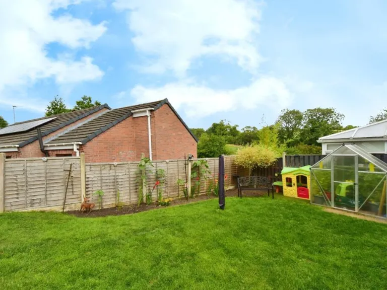
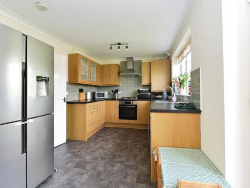
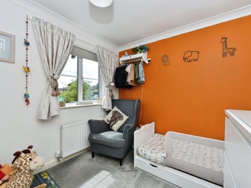
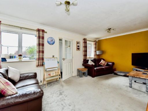
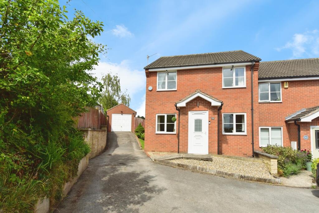
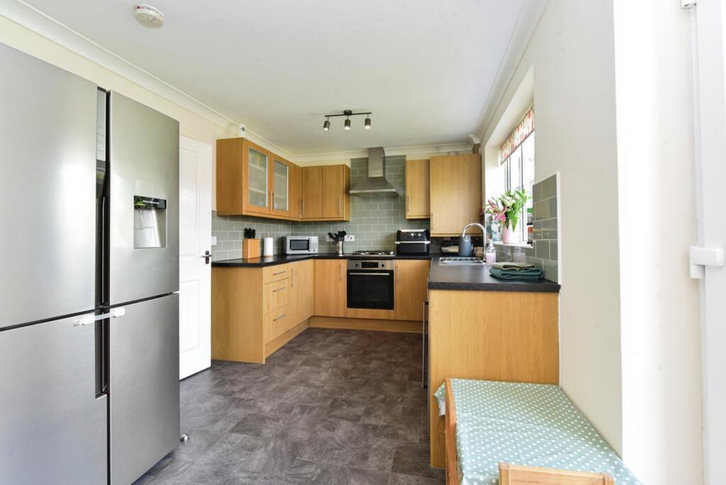
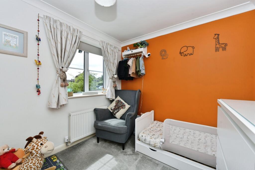
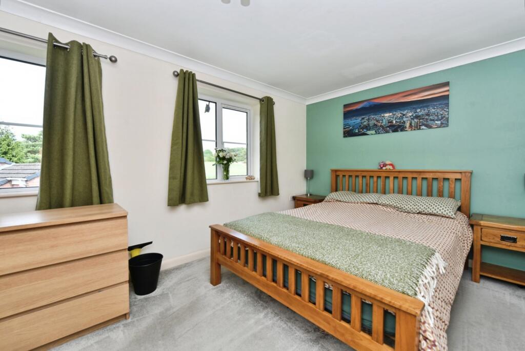
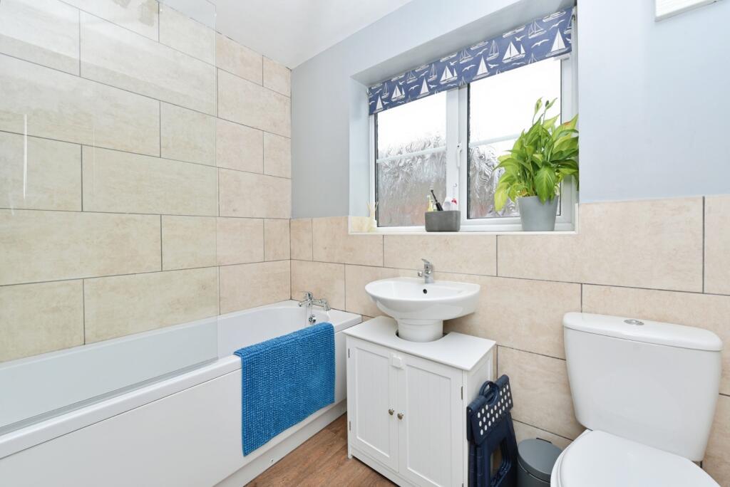
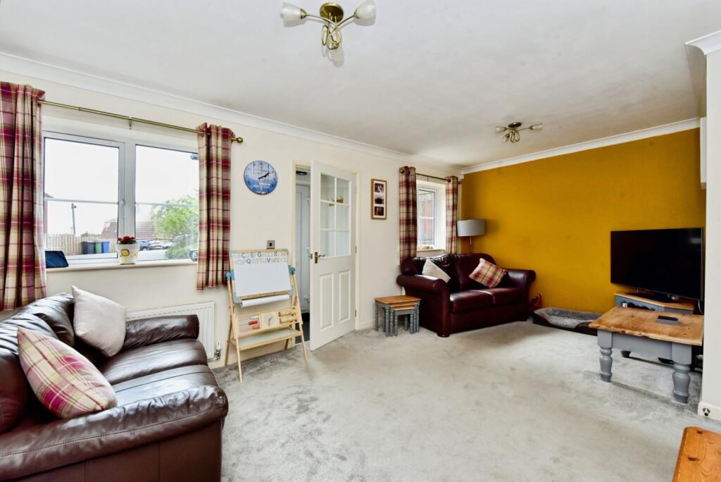
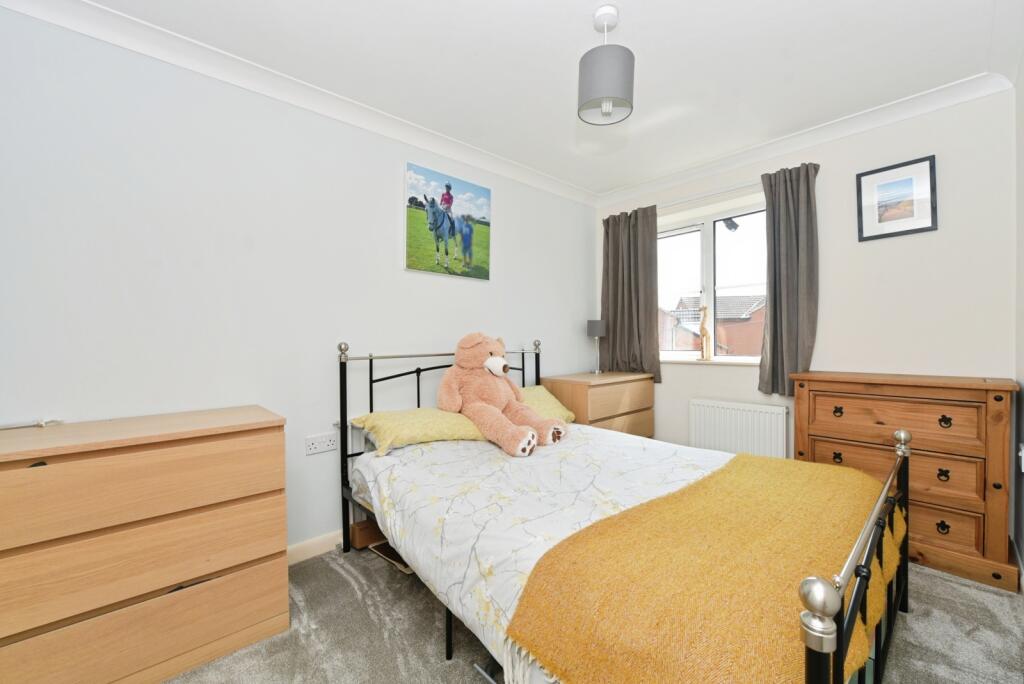
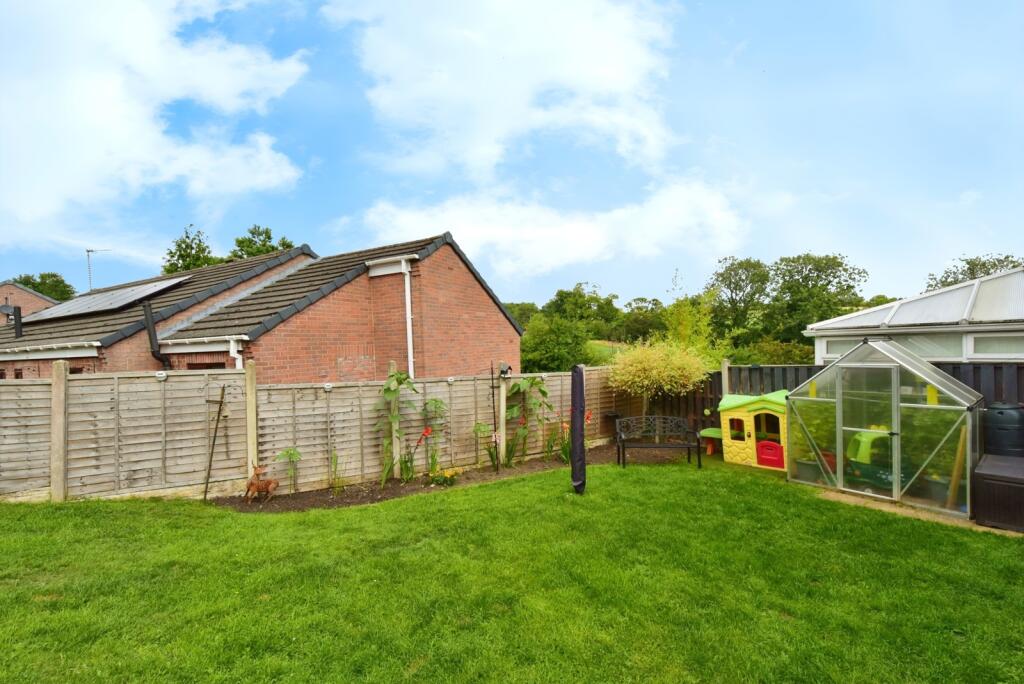
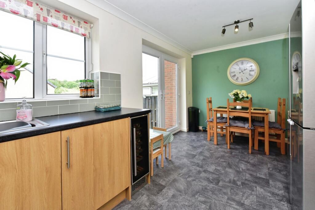
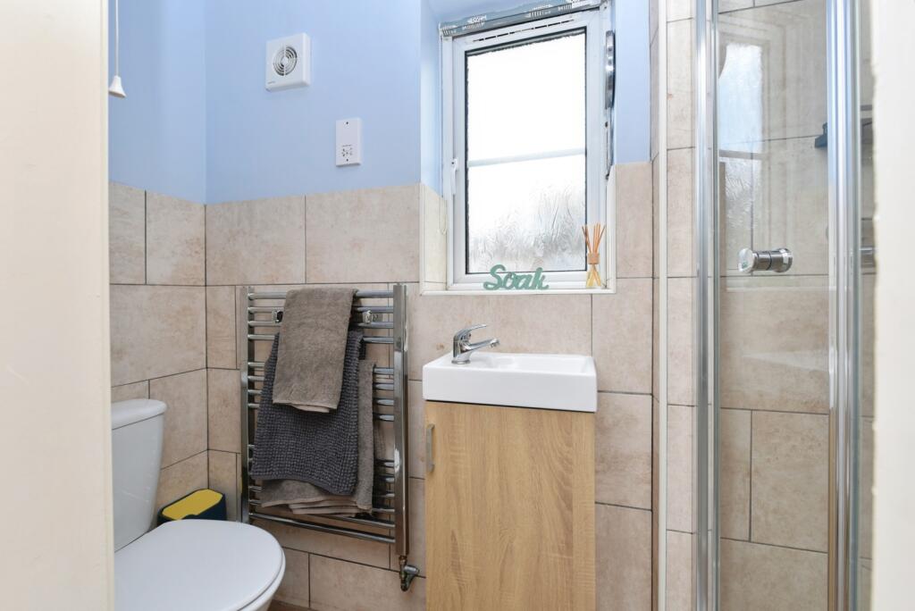
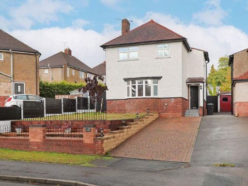
- The property is a modern semi-detached house located in a residential development in Chesterfield. It has a brick exterior, paved driveway, and a detached garage. The internal images show a spacious layout including a large living room, two good-sized bedrooms, and a modern fitted kitchen. The bathroom is contemporary and well maintained. There is a generous-sized garden with lawn, suitable for families, and the overall property size appears to be average to large for the area. The house overlooks other residential buildings and garden views; no exceptional or unique landscape views are visible.
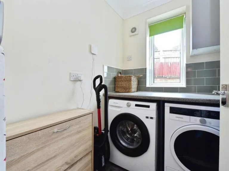
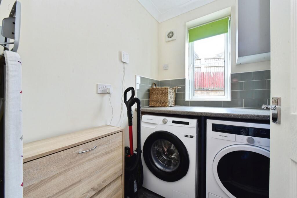
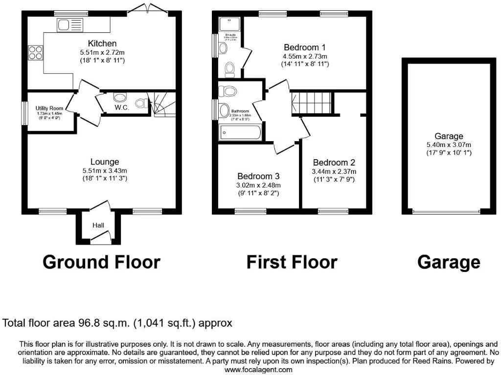
- This is a modern, three-bedroom detached family home, located on a corner plot within a private cul-de-sac. The property features a large enclosed rear garden that is both private and not overlooked, making it ideal for families seeking peace and privacy. The garden is large, with ample space for outdoor entertaining and family activities. Internally, the house offers an entrance hall, lounge, kitchen/diner, utility area, WC, three bedrooms (one with ensuite), and a family bathroom. The accommodation throughout is spacious, with generous room sizes and a well-considered layout optimizing flow and light. The garage is detached and provides secure parking and additional storage. The overall plot, house, and garden size suggest an average to above-average family home, set in a quiet and sought-after residential area creating an ideal haven for family living.
Image Descriptions
- detached house modern
- kitchen modern
Floorplan Description
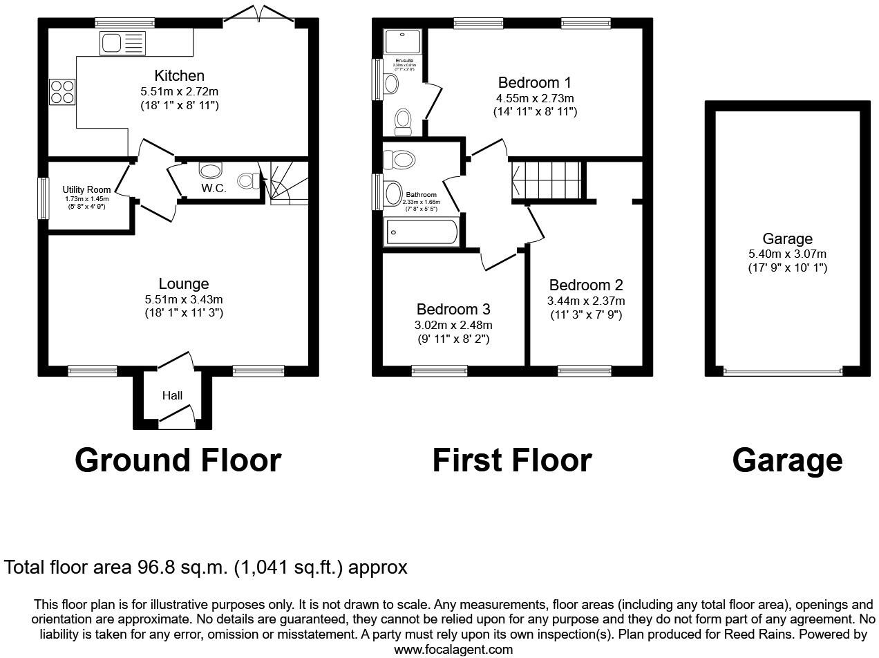
- A two-story house with integrated garage.
Rooms
- Kitchen: average
- Utility Room: small
- W.C.: small
- Lounge: average
- Bedroom 1: average
- Bathroom: small
- Bedroom 3: small
- Bedroom 2: small
Textual Property Features
Detected Visual Features
- modern house
- detached
- garage
- driveway
- brick exterior
- medium rooms
- two-story
- family home
- modern kitchen
- wood cabinets
- grey tile backsplash
- under-cabinet lighting
- vinyl flooring
- large window
- bright
- well-lit
- electric appliances
EPC Details
- Fully double glazed
- Cavity wall, as built, no insulation (assumed)
- Boiler and radiators, mains gas
- Low energy lighting in 56% of fixed outlets
- (other premises below)
Nearby Schools
- Hunloke Park Primary School
- Spire Junior School
- Calow CofE VC Primary School
- Highfield Hall Primary School
- Spire Nursery and Infant School
- William Rhodes Primary and Nursery School
- Parkside Community School
- St Peter and St Paul School
- Arkwright Primary School
- Henry Bradley Infant School
- Hollingwood Primary School
- Tupton Primary and Nursery Academy
- Walton Peak Flying High Academy
- St Mary's Catholic Primary
- Abercrombie Primary School
- Christ Church CofE Primary School
- Outwood Academy Newbold
- New Whittington Community Primary School
- Grassmoor Primary School
- Temple Normanton Junior Academy
- Hasland Junior School
- Outwood Academy Hasland Hall
- Hasland Infant School
- Brimington Manor Infant and Nursery School
- Inkersall Spencer Academy
- Whittington Moor Nursery and Infant Academy
- Brimington Junior School
Nearest Bars And Restaurants
- Id: 258213081
- Tags:
- Addr:
- Amenity: pub
- Building: yes
- Name: The Anvil
- Parking: yes
- Real_ale: no
- TagsNormalized:
- Lat: 53.2382482
- Lon: -1.3839904
- FullGeoHash: gcrnbe8pq8vb
- PartitionGeoHash: gcrn
- Images:
- FoodStandards: null
- Distance: 1329.4
,- Id: 278431233
- Tags:
- Addr:
- Amenity: fast_food
- Building: yes
- Cuisine: sandwich
- Name: Kate's Pantry
- TagsNormalized:
- Lat: 53.2208224
- Lon: -1.4080464
- FullGeoHash: gcqyzbw9y0ke
- PartitionGeoHash: gcqy
- Images:
- FoodStandards: null
- Distance: 1326
,- Id: 250065203
- Tags:
- Addr:
- Amenity: pub
- Building: yes
- Food: burgers
- Name: Devonshire Arms
- Outdoor_seating: yes
- Parking: yes
- Real_ale: 2 beers (Sharps Doom Bar and Thwaites Wainwright, may vary)
- Sky: yes
- TagsNormalized:
- Lat: 53.2207776
- Lon: -1.4070058
- FullGeoHash: gcqyzbx3w2h2
- PartitionGeoHash: gcqy
- Images:
- FoodStandards: null
- Distance: 1307.9
,- Id: 263787852
- Tags:
- Amenity: pub
- Building: yes
- Name: The Riverside Club
- TagsNormalized:
- Lat: 53.2335967
- Lon: -1.4203273
- FullGeoHash: gcqyzdvspvxj
- PartitionGeoHash: gcqy
- Images:
- FoodStandards: null
- Distance: 1299.3
,- Id: 258211687
- Tags:
- Addr:
- Amenity: fast_food
- Building: yes
- Cuisine: fish_and_chips
- Name: Calow chippy
- TagsNormalized:
- Lat: 53.2384066
- Lon: -1.3861161
- FullGeoHash: gcrnb7y8jnkc
- PartitionGeoHash: gcrn
- Images:
- FoodStandards: null
- Distance: 1221.4
}
Nearest General Shops
- Id: 278440137
- Tags:
- Landuse: retail
- Name: Willbond
- Shop: bathroom
- TagsNormalized:
- Lat: 53.23145
- Lon: -1.4186726
- FullGeoHash: gcqyzdqzwt3p
- PartitionGeoHash: gcqy
- Images:
- FoodStandards: null
- Distance: 1178.1
,- Id: 727993122
- Tags:
- Name: Head Office
- Shop: hairdresser
- TagsNormalized:
- Lat: 53.2337081
- Lon: -1.3874185
- FullGeoHash: gcrnb6vsyf3v
- PartitionGeoHash: gcrn
- Images:
- FoodStandards: null
- Distance: 923.9
,- Id: 258205588
- Tags:
- Building: yes
- Name: Le chic beauty and nails
- Shop: beauty
- TagsNormalized:
- Lat: 53.2354095
- Lon: -1.3892149
- FullGeoHash: gcrnb7hqszw7
- PartitionGeoHash: gcrn
- Images:
- FoodStandards: null
- Distance: 872
}
Nearest Grocery shops
- Id: 727993110
- Tags:
- Ele: 128
- Name: Go Local Extra
- Shop: convenience
- TagsNormalized:
- Lat: 53.233907
- Lon: -1.3853119
- FullGeoHash: gcrnb6zjzzs8
- PartitionGeoHash: gcrn
- Images:
- FoodStandards: null
- Distance: 1065.7
,- Id: 727993133
- Tags:
- Ele: 134
- Name: Pet store
- Shop: convenience
- TagsNormalized:
- Lat: 53.2336308
- Lon: -1.388949
- FullGeoHash: gcrnb6us7hh8
- PartitionGeoHash: gcrn
- Images:
- FoodStandards: null
- Distance: 822.6
,- Id: 279247164
- Tags:
- Building: yes
- Name: Top Road sandwich shop
- Shop: convenience
- Source: View from N;Bing
- TagsNormalized:
- Lat: 53.2336052
- Lon: -1.3900268
- FullGeoHash: gcrnb6gu4p2b
- PartitionGeoHash: gcrn
- Images:
- FoodStandards: null
- Distance: 752.1
}
Nearest Supermarkets
- Id: 145173928
- Tags:
- Addr:
- City: Chesterfield
- Postcode: S41 7EW
- Street: Lockoford Lane
- Brand: Tesco Extra
- Brand:wikidata: Q25172225
- Brand:wikipedia: en:Tesco Extra
- Building: yes
- Fhrs:
- Layer: 1
- Name: Tesco Extra
- Opening_hours: Mo-Fr 08:00-22:30; Sa 08:00-22:00; Su 10:00-16:00
- Shop: supermarket
- Source: Bing;local_knowledge
- Source:addr: FHRS Open Data
- Website: https://www.tesco.com/store-locator/chesterfield/lockoford-lane
- TagsNormalized:
- tesco
- tesco extra
- supermarket
- shop
- Lat: 53.2525553
- Lon: -1.4239919
- FullGeoHash: gcqyzw74def9
- PartitionGeoHash: gcqy
- Images:
- FoodStandards:
- Id: 215291
- FHRSID: 215291
- LocalAuthorityBusinessID: PI/000070595
- BusinessName: Tesco Extra
- BusinessType: Retailers - supermarkets/hypermarkets
- BusinessTypeID: 7840
- AddressLine1: Tesco Extra
- AddressLine2: Lockoford Lane
- AddressLine3: null
- AddressLine4: Chesterfield
- PostCode: S41 7EW
- RatingValue: 5
- RatingKey: fhrs_5_en-GB
- RatingDate: 2022-06-10
- LocalAuthorityCode: 064
- LocalAuthorityName: Chesterfield
- LocalAuthorityWebSite: http://www.chesterfield.gov.uk
- LocalAuthorityEmailAddress: food@chesterfield.gov.uk
- Scores:
- Hygiene: 0
- Structural: 0
- ConfidenceInManagement: 0
- NewRatingPending: false
- Geocode:
- Longitude: -1.42609703540802
- Latitude: 53.25143432617190
- Distance: 2752.9
,- Id: 145172474
- Tags:
- Brand: Sainsbury's
- Brand:wikidata: Q152096
- Brand:wikipedia: en:Sainsbury's
- Building: yes
- Name: Sainsbury's
- Opening_hours: Mo-Fr 07:00-23:00; Sa 07:00-22:00; Su 10:00-16:00
- Shop: supermarket
- Source: Bing;local_knowledge
- TagsNormalized:
- sainsburys
- supermarket
- shop
- Lat: 53.2539368
- Lon: -1.4181635
- FullGeoHash: gcqyzwx6dmkd
- PartitionGeoHash: gcqy
- Images:
- FoodStandards: null
- Distance: 2696
,- Id: 278437079
- Tags:
- Addr:
- City: Chesterfield
- Postcode: S41 0HL
- Street: Spital Lane
- Building: yes
- Name: Co-op
- Opening_hours: 07:00-23:00
- Operator: The Co-operative Group
- Shop: supermarket
- Wheelchair: yes
- TagsNormalized:
- Lat: 53.2293331
- Lon: -1.4161285
- FullGeoHash: gcqyzf0g3ffh
- PartitionGeoHash: gcqy
- Images:
- FoodStandards: null
- Distance: 1049.3
}
Nearest Religious buildings
- Id: 727993117
- Tags:
- Amenity: place_of_worship
- Ele: 126.7786865
- Name: Calow United Reformed Church
- Religion: christian
- TagsNormalized:
- place of worship
- church
- united reformed
- christian
- Lat: 53.2343051
- Lon: -1.3841371
- FullGeoHash: gcrnbe00738x
- PartitionGeoHash: gcrn
- Images:
- FoodStandards: null
- Distance: 1151.5
,- Id: 879345227
- Tags:
- Amenity: place_of_worship
- Building: church
- Denomination: anglican
- Name: St Leonard's
- Religion: christian
- Wikidata: Q105094432
- TagsNormalized:
- place of worship
- church
- anglican
- christian
- Lat: 53.2308936
- Lon: -1.4144423
- FullGeoHash: gcqyzf6h3jg2
- PartitionGeoHash: gcqy
- Images:
- FoodStandards: null
- Distance: 903.1
,- Id: 424315434
- Tags:
- Amenity: place_of_worship
- Building: church
- Denomination: anglican
- Name: St Peter
- Religion: christian
- Wikidata: Q26620047
- TagsNormalized:
- place of worship
- church
- anglican
- christian
- Lat: 53.2340919
- Lon: -1.3904417
- FullGeoHash: gcrnb6gx03gx
- PartitionGeoHash: gcrn
- Images:
- FoodStandards: null
- Distance: 740.7
}
Nearest Medical buildings
- Id: 241918653
- Tags:
- Addr:
- Amenity: dentist
- Building: yes
- Healthcare: dentist
- TagsNormalized:
- Lat: 53.2227172
- Lon: -1.4113663
- FullGeoHash: gcqyzbukbc94
- PartitionGeoHash: gcqy
- Images:
- FoodStandards: null
- Distance: 1239.6
,- Id: 279247168
- Tags:
- Amenity: pharmacy
- Building: yes
- Healthcare: pharmacy
- Name: Calow Pharmacy
- TagsNormalized:
- Lat: 53.2361354
- Lon: -1.3870088
- FullGeoHash: gcrnb7q4bqgm
- PartitionGeoHash: gcrn
- Images:
- FoodStandards: null
- Distance: 1039.4
,- Id: 279243877
- Tags:
- Amenity: hospital
- Healthcare: hospital
- Name: Chesterfield Royal Hospital
- Operator: Chesterfield Royal Hospital NHS Foundation Trust
- Operator:wikidata: Q16890251
- Wheelchair: yes
- Wikidata: Q30279783
- TagsNormalized:
- Lat: 53.2362541
- Lon: -1.3982786
- FullGeoHash: gcrnb5mg9tpc
- PartitionGeoHash: gcrn
- Images:
- FoodStandards: null
- Distance: 508.9
,- Id: 11761903
- Tags:
- Name: Calow, Chesterfield Royal Hospital
- Public_transport: stop_area
- Type: public_transport
- TagsNormalized:
- Lat: 53.2355888
- Lon: -1.3969796
- FullGeoHash: gcrnb5nzb108
- PartitionGeoHash: gcrn
- Images:
- FoodStandards: null
- Distance: 482.5
}
Nearest Leisure Facilities
- Id: 111871399
- Tags:
- Leisure: park
- Name: Spital Park
- Source: local_knowledge;google_maps
- TagsNormalized:
- Lat: 53.2311711
- Lon: -1.4078017
- FullGeoHash: gcqyzfqy5cdb
- PartitionGeoHash: gcqy
- Images:
- FoodStandards: null
- Distance: 461.8
,- Id: 568034745
- Tags:
- Leisure: playground
- Wheelchair: limited
- TagsNormalized:
- Lat: 53.2286589
- Lon: -1.3983596
- FullGeoHash: gcrnb1vxrv5w
- PartitionGeoHash: gcrn
- Images:
- FoodStandards: null
- Distance: 408.4
,- Id: 491328343
- Tags:
- TagsNormalized:
- Lat: 53.228969
- Lon: -1.3983688
- FullGeoHash: gcrnb4j9pxh8
- PartitionGeoHash: gcrn
- Images:
- FoodStandards: null
- Distance: 377.2
,- Id: 491328344
- Tags:
- TagsNormalized:
- Lat: 53.2289516
- Lon: -1.3984525
- FullGeoHash: gcrnb4j9jey0
- PartitionGeoHash: gcrn
- Images:
- FoodStandards: null
- Distance: 376.4
,- Id: 491328332
- Tags:
- Leisure: pitch
- Sport: soccer
- TagsNormalized:
- Lat: 53.2312499
- Lon: -1.404824
- FullGeoHash: gcrnb43n90pq
- PartitionGeoHash: gcrn
- Images:
- FoodStandards: null
- Distance: 267.4
}
Nearest Tourist attractions
- Id: 1364305891
- Tags:
- Name: The Anis Louise Guest House
- Source: survey
- Tourism: guest_house
- TagsNormalized:
- Lat: 53.236818
- Lon: -1.4348442
- FullGeoHash: gcqyz77nvwnt
- PartitionGeoHash: gcqy
- Images:
- FoodStandards: null
- Distance: 2316.3
,- Id: 121952316
- Tags:
- Addr:
- Building: retail
- Name: Chesterfield Lodge Bed and Breakfast
- Source: Bing;survey
- Tourism: guest_house
- TagsNormalized:
- retail
- bed
- guest house
- tourism
- Lat: 53.223313
- Lon: -1.4269638
- FullGeoHash: gcqyz90bm2ds
- PartitionGeoHash: gcqy
- Images:
- FoodStandards: null
- Distance: 1978.9
,- Id: 415305120
- Tags:
- Building: yes
- Fee: no
- Name: Chesterfield Museum
- Note: Temporarily closed for renovations
- Opening_hours: "closed"
- Tourism: museum
- Wikidata: Q5093815
- Wikipedia: en:Chesterfield Museum and Art Gallery
- TagsNormalized:
- Lat: 53.2366308
- Lon: -1.4235173
- FullGeoHash: gcqyze7mvek8
- PartitionGeoHash: gcqy
- Images:
- FoodStandards: null
- Distance: 1585.9
}
Nearest Train stations
- Id: 3170172466
- Tags:
- Name: Langwith-Whaley Thorns
- Naptan:
- Network: National Rail
- Public_transport: station
- Railway: station
- Ref:
- Train: yes
- Wikidata: Q2400406
- Wikipedia: en:Langwith-Whaley Thorns railway station
- TagsNormalized:
- Lat: 53.2327375
- Lon: -1.2092803
- FullGeoHash: gcrnu6xrjtx2
- PartitionGeoHash: gcrn
- Images:
- FoodStandards: null
- Distance: 12760.4
,- Id: 370186628
- Tags:
- Name: Dronfield
- Naptan:
- Network: National Rail
- Platforms: 2
- Public_transport: station
- Railway: station
- Ref:
- Wikidata: Q2161199
- Wikipedia: en:Dronfield railway station
- TagsNormalized:
- Lat: 53.3014
- Lon: -1.4692529
- FullGeoHash: gcqznx4p5vje
- PartitionGeoHash: gcqz
- Images:
- FoodStandards: null
- Distance: 8955.4
,- Id: 1716256015
- Tags:
- Name: Roundhouse Halt
- Public_transport: station
- Railway: station
- Usage: tourism
- Website: https://www.barrowhill.org/
- TagsNormalized:
- Lat: 53.2746594
- Lon: -1.3813376
- FullGeoHash: gcrp0d65ks21
- PartitionGeoHash: gcrp
- Images:
- FoodStandards: null
- Distance: 4923.1
,- Id: 102031003
- Tags:
- Building: train_station
- Name: Barrow Hill Roundhouse
- Railway: turntable
- Tourism: attraction
- Wikidata: Q4863884
- Wikipedia: en:Barrow Hill Engine Shed
- TagsNormalized:
- station
- train
- train station
- railway
- attraction
- tourism
- Lat: 53.2744292
- Lon: -1.381839
- FullGeoHash: gcrp0d3f0c6h
- PartitionGeoHash: gcrp
- Images:
- FoodStandards: null
- Distance: 4889.6
,- Id: 7154300845
- Tags:
- Name: Chesterfield
- Naptan:
- Network: National Rail
- Public_transport: station
- Railway: station
- Ref:
- Wikidata: Q2645921
- Wikipedia: en:Chesterfield railway station
- TagsNormalized:
- Lat: 53.2382236
- Lon: -1.4197283
- FullGeoHash: gcqyzewpjujv
- PartitionGeoHash: gcqy
- Images:
- FoodStandards: null
- Distance: 1427.3
}
Nearest Bus stations and stops
- Id: 1161095106
- Tags:
- Bus: yes
- Ele: 107.3120117
- Highway: bus_stop
- Public_transport: platform
- Wheelchair: yes
- TagsNormalized:
- Lat: 53.2297435
- Lon: -1.4012773
- FullGeoHash: gcrnb45tez7u
- PartitionGeoHash: gcrn
- Images:
- FoodStandards: null
- Distance: 248.9
,- Id: 1692547635
- Tags:
- Bus: yes
- Highway: bus_stop
- Public_transport: platform
- Wheelchair: yes
- TagsNormalized:
- Lat: 53.2298725
- Lon: -1.401642
- FullGeoHash: gcrnb45q7r7v
- PartitionGeoHash: gcrn
- Images:
- FoodStandards: null
- Distance: 237.8
,- Id: 1161102407
- Tags:
- Bus: yes
- Ele: 119.5687256
- Highway: bus_stop
- Name: Royal hospital gates
- Public_transport: platform
- Shelter: no
- Tactile_paving: no
- TagsNormalized:
- Lat: 53.2336309
- Lon: -1.3991313
- FullGeoHash: gcrnb4vhmuh1
- PartitionGeoHash: gcrn
- Images:
- FoodStandards: null
- Distance: 221.9
,- Id: 4085460289
- Tags:
- Bus: yes
- Highway: bus_stop
- Public_transport: platform
- TagsNormalized:
- Lat: 53.2328875
- Lon: -1.403222
- FullGeoHash: gcrnb4f0n93y
- PartitionGeoHash: gcrn
- Images:
- FoodStandards: null
- Distance: 179.6
,- Id: 4085460290
- Tags:
- Bus: yes
- Highway: bus_stop
- Public_transport: platform
- TagsNormalized:
- Lat: 53.2329132
- Lon: -1.4030342
- FullGeoHash: gcrnb4f24ymb
- PartitionGeoHash: gcrn
- Images:
- FoodStandards: null
- Distance: 171.2
}
Nearest Hotels
- Id: 6548201961
- Tags:
- Addr:
- City: Chesterfield
- Postcode: S40 1UN
- Street: Elder Way
- Brand: Premier Inn
- Brand:wikidata: Q2108626
- Brand:wikipedia: en:Premier Inn
- Internet_access: wlan
- Internet_access:fee: customers
- Internet_access:operator: Virgin Media
- Internet_access:ssid: Premier Inn Free Wi-Fi
- Name: Premier Inn Chesterfield Town Centre
- Tourism: hotel
- TagsNormalized:
- Lat: 53.2366069
- Lon: -1.4280567
- FullGeoHash: gcqyze2jeyg9
- PartitionGeoHash: gcqy
- Images:
- FoodStandards: null
- Distance: 1873.3
,- Id: 503951697
- Tags:
- Addr:
- City: Chesterfield
- Housename: Hotel ibis Chesterfield Centre - Market Town
- Postcode: S41 7RW
- Street: Lordsmill Street
- Brand: Ibis
- Brand:wikidata: Q920166
- Brand:wikipedia: en:Ibis (hotel)
- Name: Hotel ibis Chesterfield Centre - Market Town
- Note: FIXME - needs service roads
- Stars: 2
- Tourism: hotel
- TagsNormalized:
- Lat: 53.2329619
- Lon: -1.4228844
- FullGeoHash: gcqyzdgbkrk6
- PartitionGeoHash: gcqy
- Images:
- FoodStandards: null
- Distance: 1461.1
,- Id: 391076123
- Tags:
- Amenity: pub
- Name: Hasland Hotel
- Old_name: The New Inn
- Real_ale: 6 varying beers, usually including Peak Aleas
- TagsNormalized:
- Lat: 53.2216914
- Lon: -1.4040766
- FullGeoHash: gcrnb09wfdke
- PartitionGeoHash: gcrn
- Images:
- FoodStandards: null
- Distance: 1161.8
}
Tags
- modern house
- detached
- garage
- driveway
- brick exterior
- medium rooms
- two-story
- family home
- modern kitchen
- wood cabinets
- grey tile backsplash
- under-cabinet lighting
- vinyl flooring
- large window
- bright
- well-lit
- electric appliances
Local Market Stats
- Average Price/sqft: £215
- Avg Income: £36000
- Rental Yield: 3.9%
- Social Housing: 15%
- Planning Success Rate: 100%
AirBnB Data
- 1km average: £75/night
- Listings in 1km: 1
Similar Properties
 3 bedroom detached house for sale in Hady Crescent, Chesterfield, S41 — £300,000 • 3 bed • 1 bath • 954 ft²
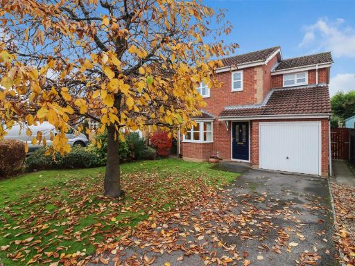 3 bedroom house for sale in Ladywood Drive, Chesterfield, S41 — £299,950 • 3 bed • 2 bath • 1023 ft²
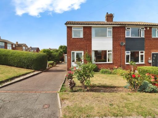 3 bedroom semi-detached house for sale in Glenfield Crescent, Chesterfield, Derbyshire, S41 — £220,000 • 3 bed • 1 bath • 794 ft²
 3 bedroom detached house for sale in Woodcote Way, Walton, Chesterfield, S40 — £315,000 • 3 bed • 3 bath • 1112 ft²
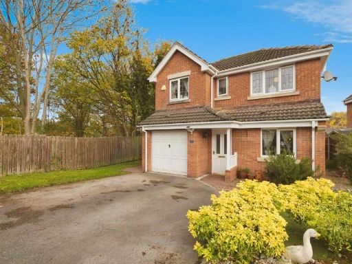 4 bedroom detached house for sale in Cragside Close, Chesterfield, S41 0FH, S41 — £325,000 • 4 bed • 3 bath • 1041 ft²
 3 bedroom detached house for sale in Norwood Avenue, Hasland, Chesterfield, S41 0NH, S41 — £318,500 • 3 bed • 2 bath • 1190 ft²
Meta
- {
"@context": "https://schema.org",
"@type": "Residence",
"name": "3 bedroom semidetached house for sale in Houldsworth Drive,…",
"description": "",
"url": "https://propertypiper.co.uk/property/c494bc1a-97f3-4322-b06d-a8e420916e19",
"image": "https://image-a.propertypiper.co.uk/616b7ccb-c525-46a0-a82a-34bb3bdbfefe-1024.jpeg",
"address": {
"@type": "PostalAddress",
"streetAddress": "34 HOULDSWORTH DRIVE CHESTERFIELD",
"postalCode": "S41 0BS",
"addressLocality": "Chesterfield",
"addressRegion": "Chesterfield",
"addressCountry": "England"
},
"geo": {
"@type": "GeoCoordinates",
"latitude": 53.23197557426422,
"longitude": -1.4009944957394151
},
"numberOfRooms": 3,
"numberOfBathroomsTotal": 2,
"floorSize": {
"@type": "QuantitativeValue",
"value": 1041,
"unitCode": "FTK"
},
"offers": {
"@type": "Offer",
"price": 250000,
"priceCurrency": "GBP",
"availability": "https://schema.org/InStock"
},
"additionalProperty": [
{
"@type": "PropertyValue",
"name": "Feature",
"value": "modern house"
},
{
"@type": "PropertyValue",
"name": "Feature",
"value": "detached"
},
{
"@type": "PropertyValue",
"name": "Feature",
"value": "garage"
},
{
"@type": "PropertyValue",
"name": "Feature",
"value": "driveway"
},
{
"@type": "PropertyValue",
"name": "Feature",
"value": "brick exterior"
},
{
"@type": "PropertyValue",
"name": "Feature",
"value": "medium rooms"
},
{
"@type": "PropertyValue",
"name": "Feature",
"value": "two-story"
},
{
"@type": "PropertyValue",
"name": "Feature",
"value": "family home"
},
{
"@type": "PropertyValue",
"name": "Feature",
"value": "modern kitchen"
},
{
"@type": "PropertyValue",
"name": "Feature",
"value": "wood cabinets"
},
{
"@type": "PropertyValue",
"name": "Feature",
"value": "grey tile backsplash"
},
{
"@type": "PropertyValue",
"name": "Feature",
"value": "under-cabinet lighting"
},
{
"@type": "PropertyValue",
"name": "Feature",
"value": "vinyl flooring"
},
{
"@type": "PropertyValue",
"name": "Feature",
"value": "large window"
},
{
"@type": "PropertyValue",
"name": "Feature",
"value": "bright"
},
{
"@type": "PropertyValue",
"name": "Feature",
"value": "well-lit"
},
{
"@type": "PropertyValue",
"name": "Feature",
"value": "electric appliances"
}
]
}
High Res Floorplan Images
Compatible Floorplan Images
FloorplanImages Thumbnail