CO9 2JW - 3 bedroom penthouse for sale in Parsonage Street, Halstead,…
View on Property Piper
3 bedroom penthouse for sale in Parsonage Street, Halstead, CO9 2JW, CO9
Property Details
- Price: £400000
- Bedrooms: 3
- Bathrooms: 2
- Property Type: undefined
- Property SubType: undefined
Image Descriptions
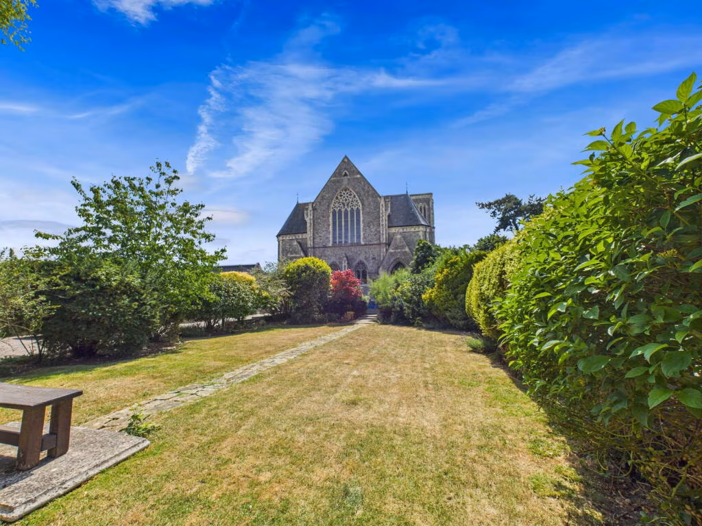
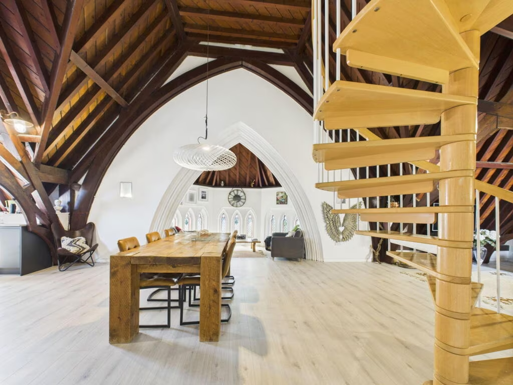
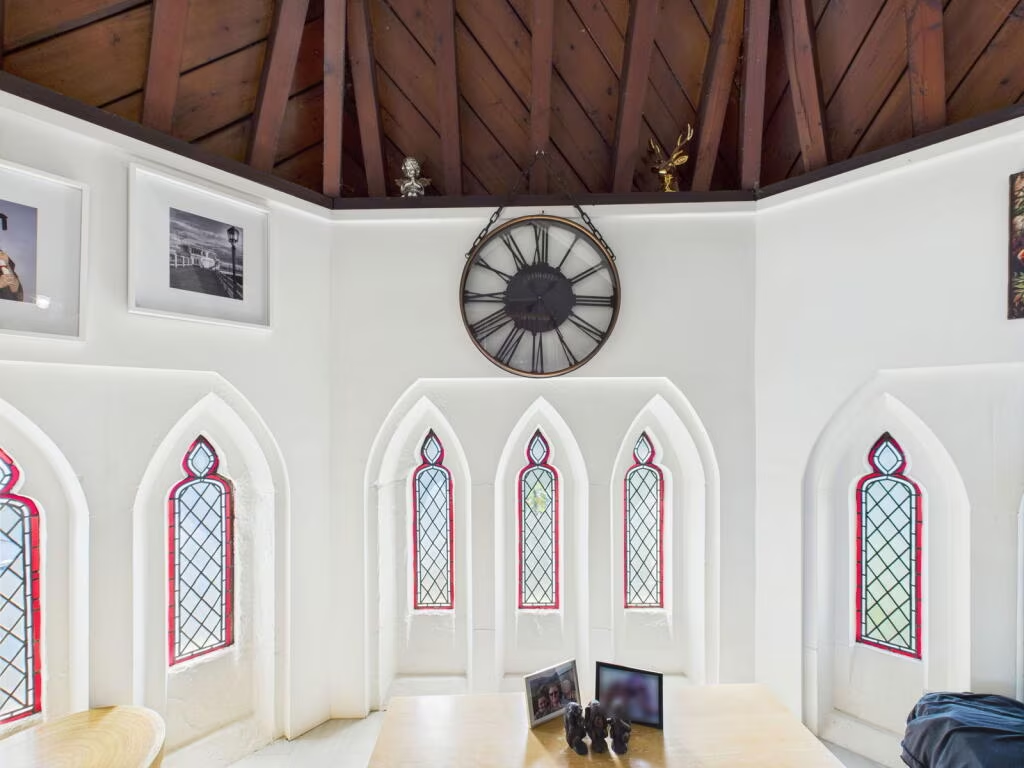
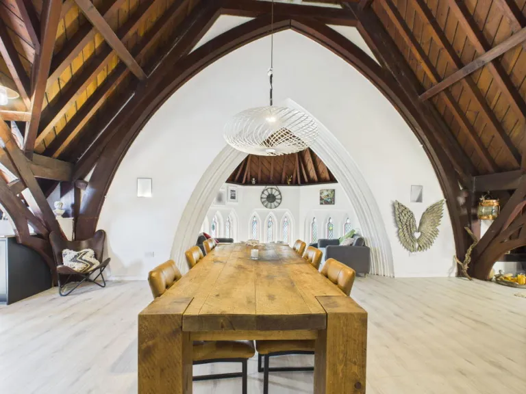
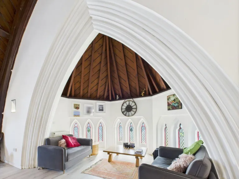
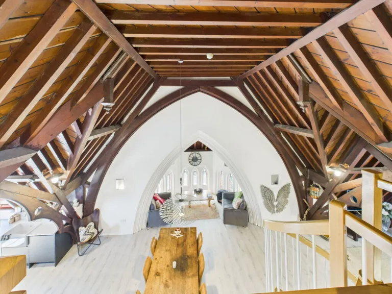
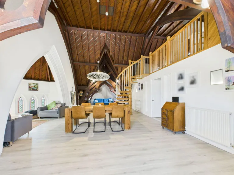
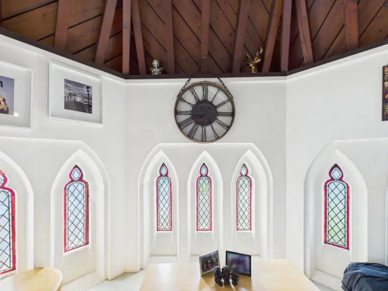
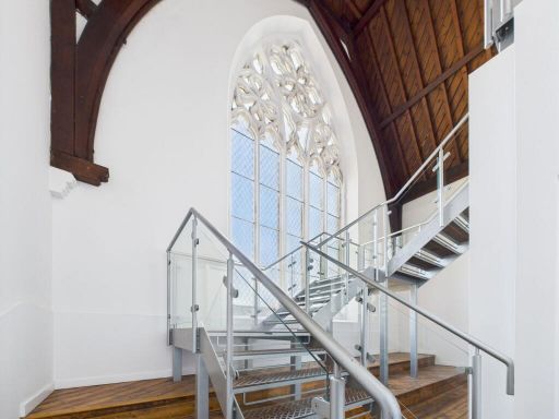
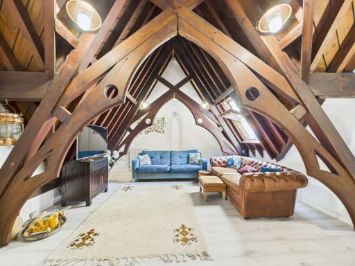
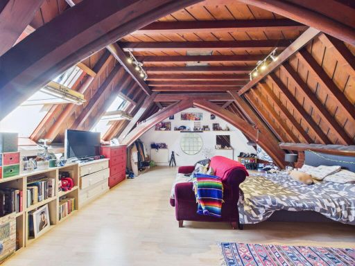
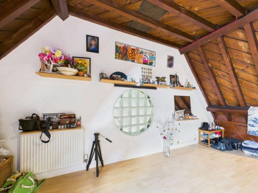
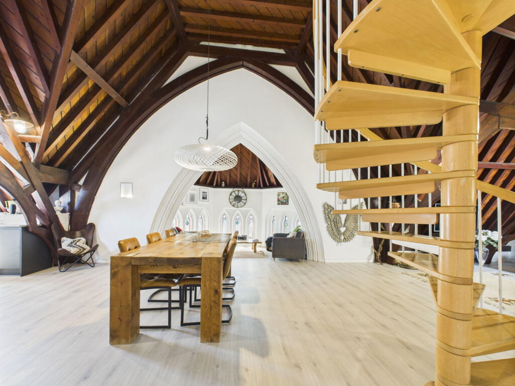
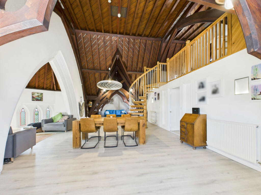
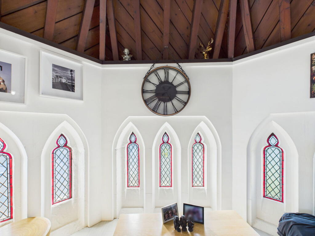
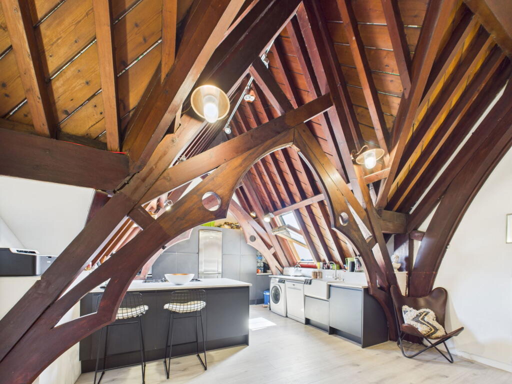
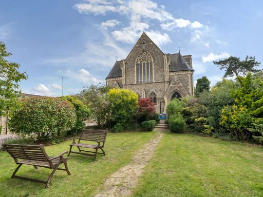
- church or chapel Gothic Revival
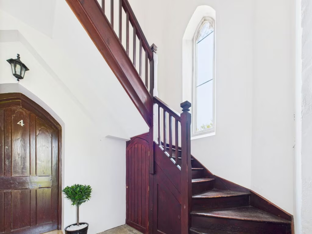
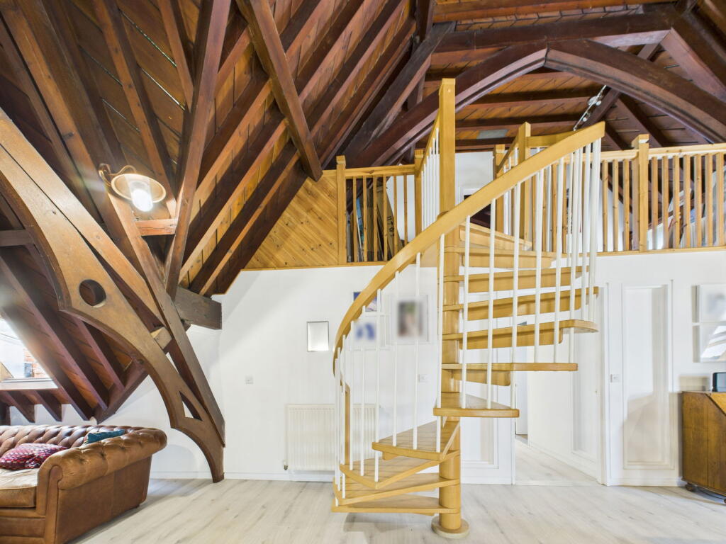
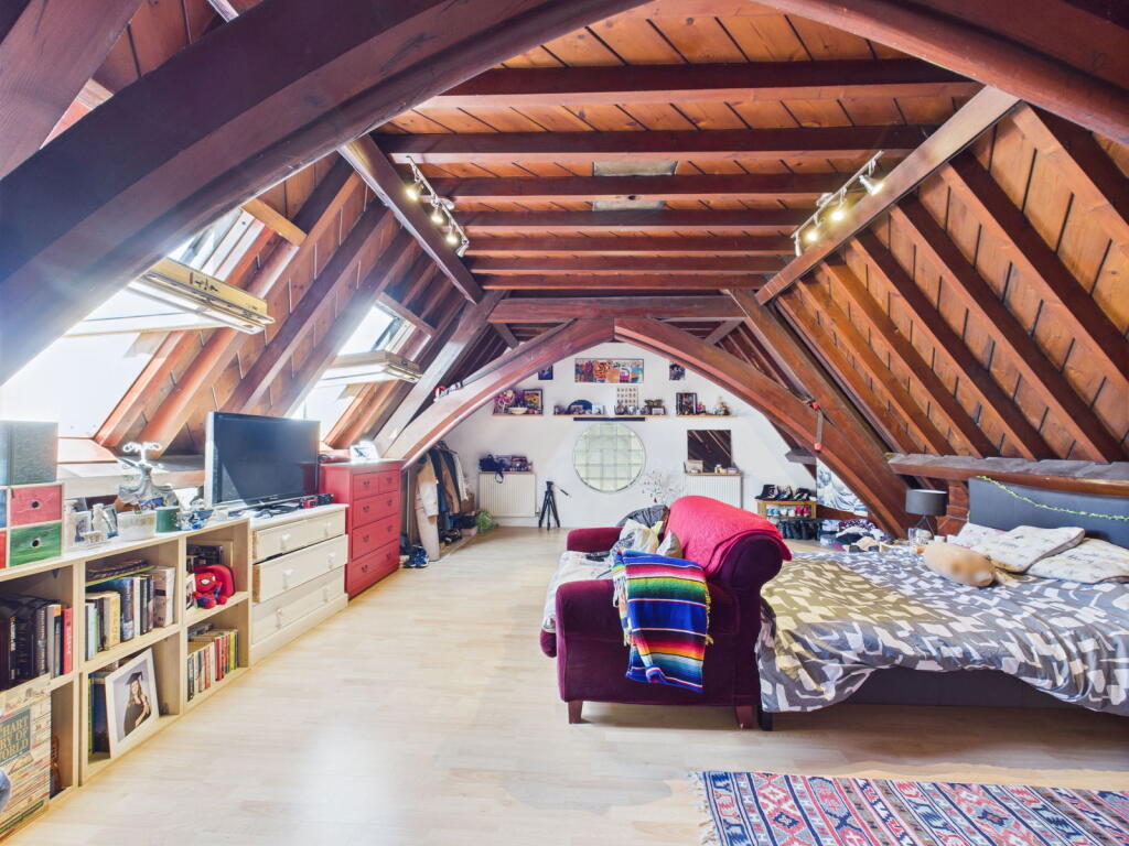
- staircase Victorian Gothic
Floorplan Description
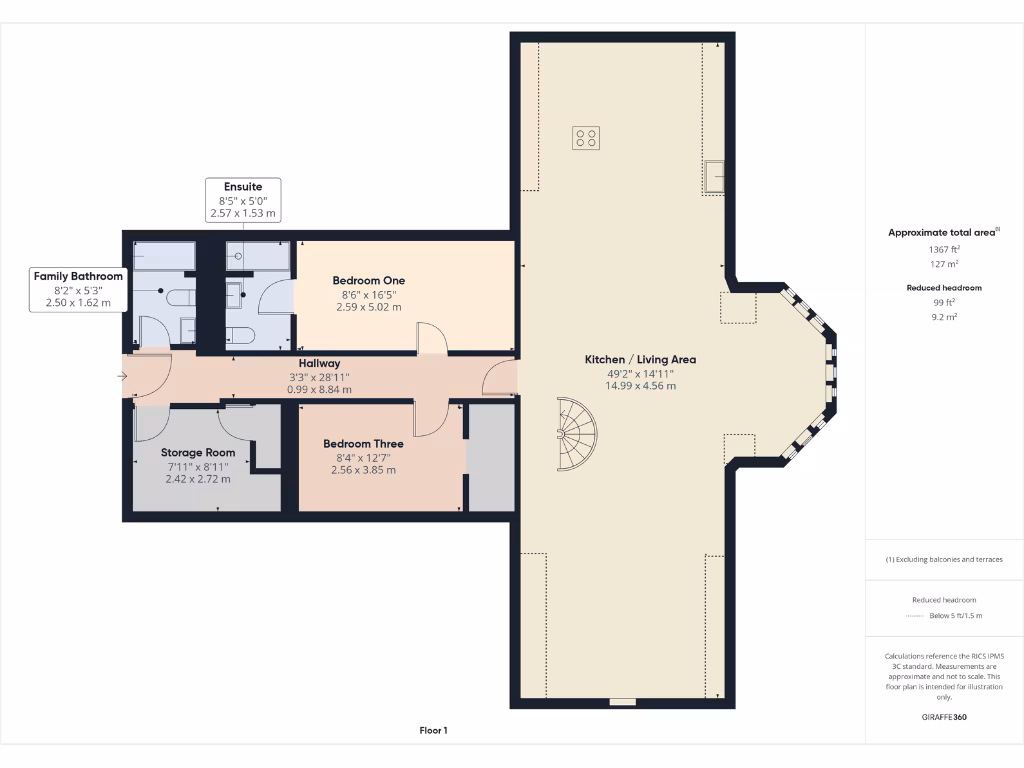
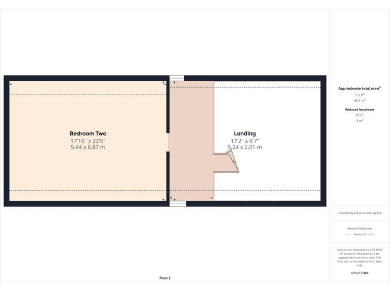
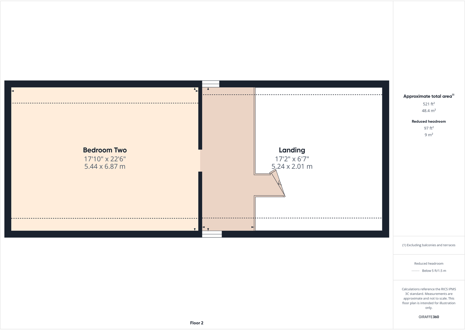
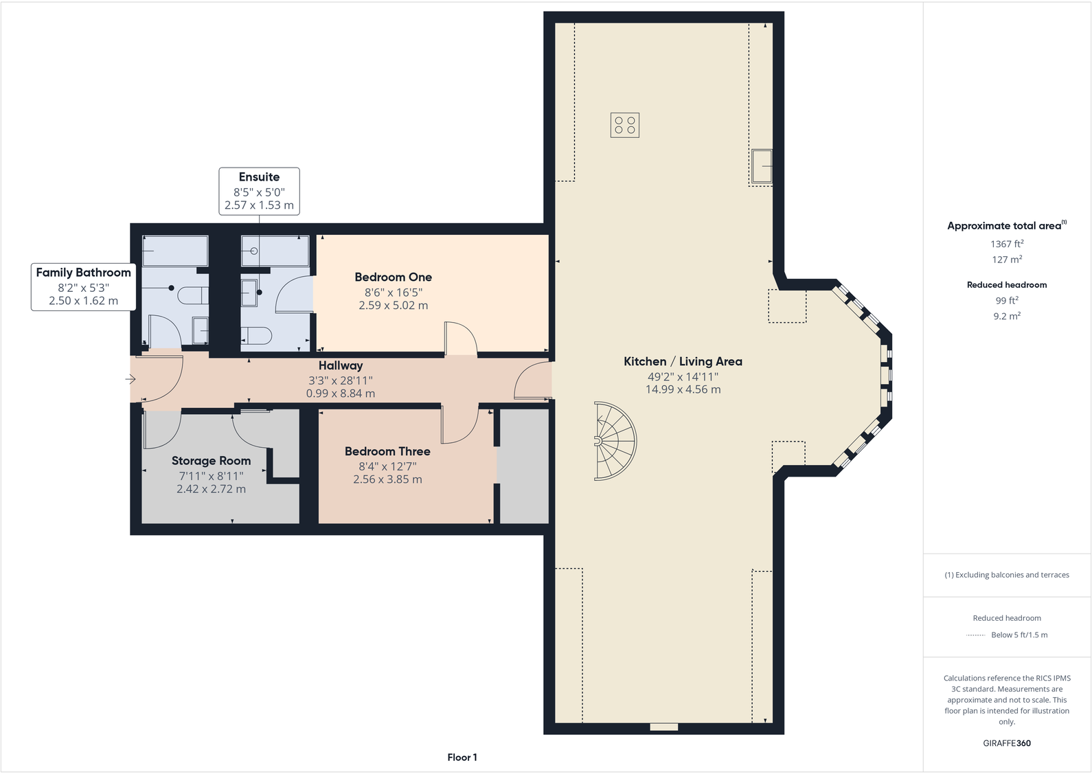
- Second floor plan showing Bedroom Two and Landing
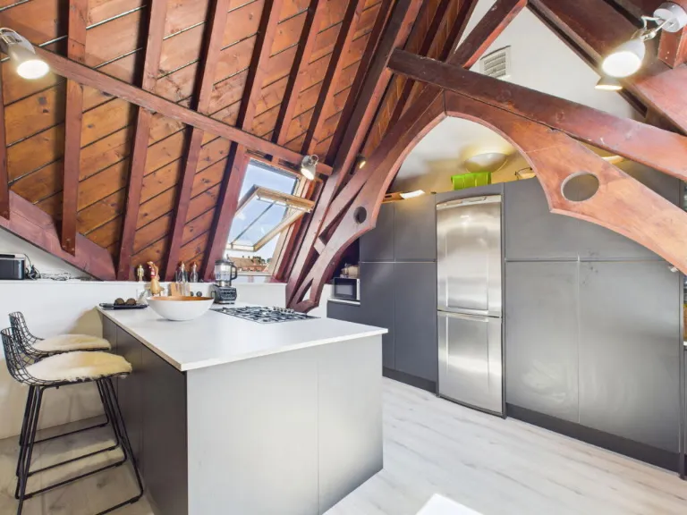
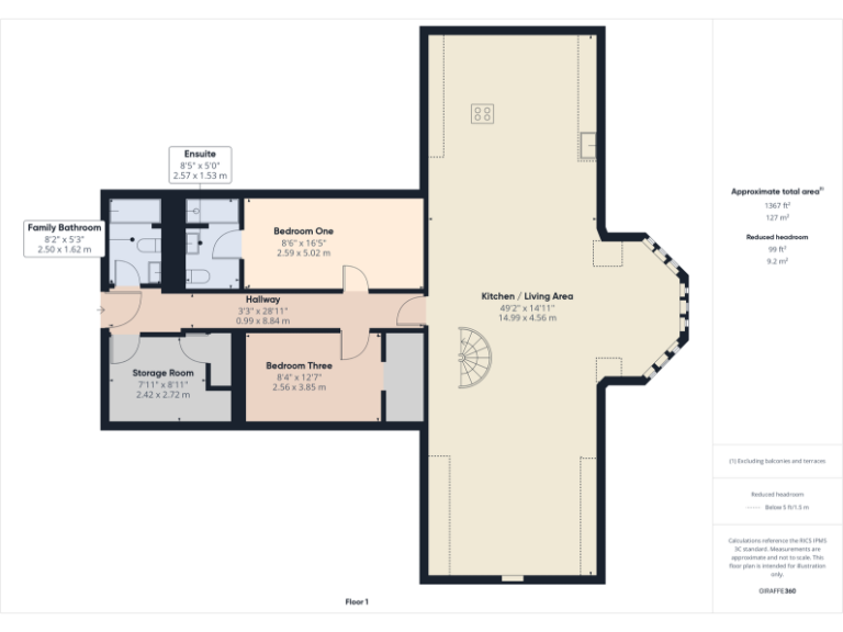
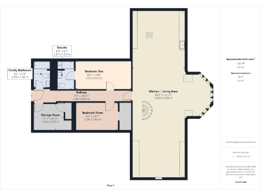
- First-floor apartment with large open Kitchen / Living Area and three bedrooms
Rooms
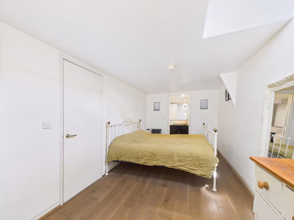
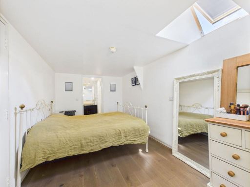
- Bedroom Two:
- Landing:
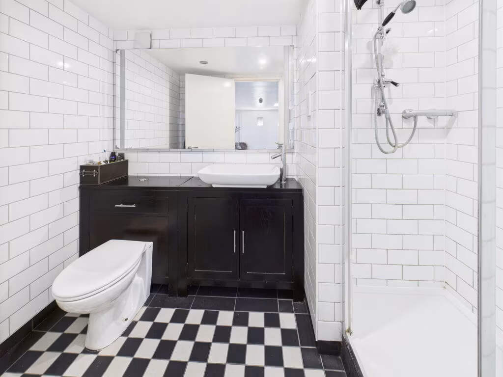
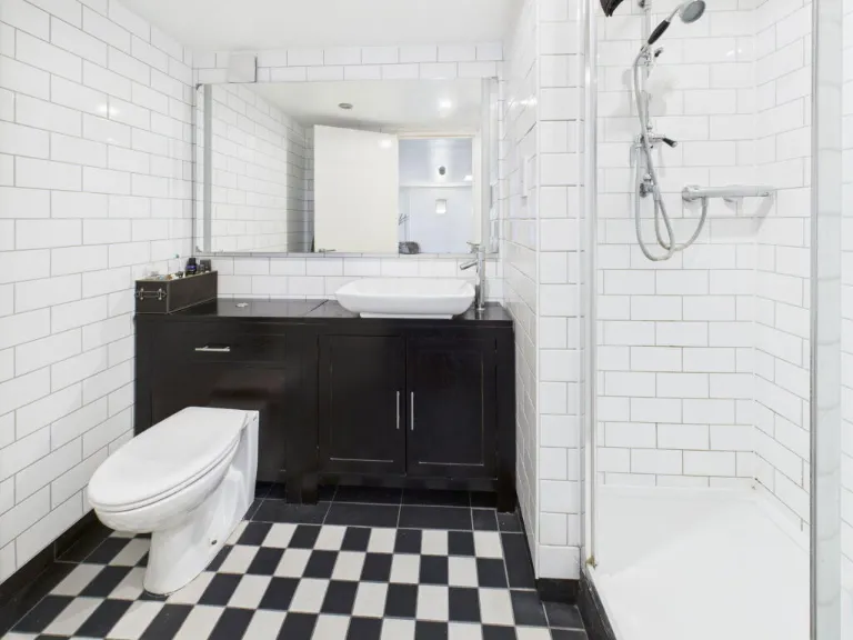
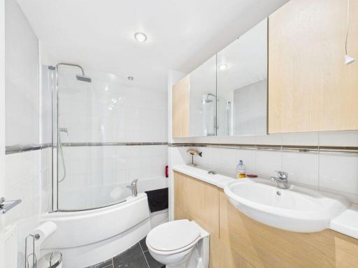
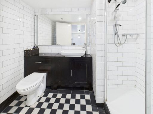
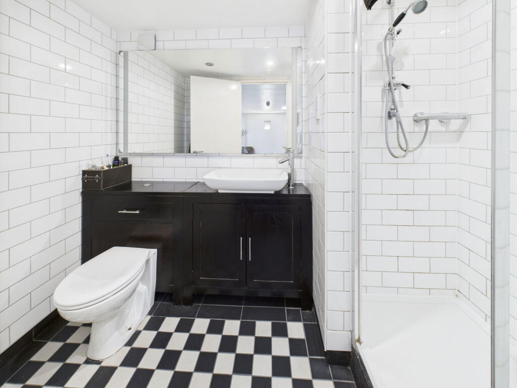
- Family Bathroom:
- Ensuite:
- Bedroom One:
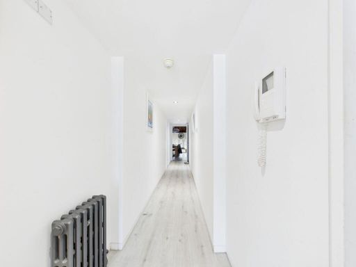
- Hallway:
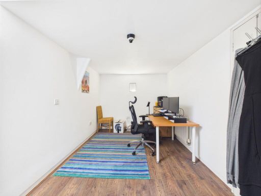
- Storage Room:
- Bedroom Three:
- Kitchen / Living Area:
Textual Property Features
Detected Visual Features
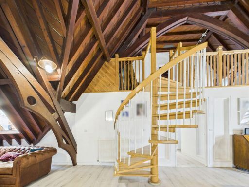
- Gothic Revival
- church
- chapel
- conversion opportunity
- period property
- large windows
- stone facade
- historic
- architectural interest
- Victorian
- Gothic
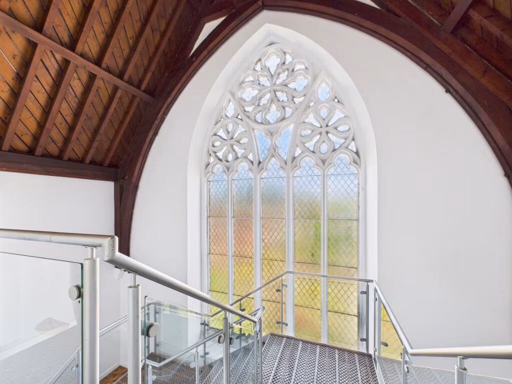
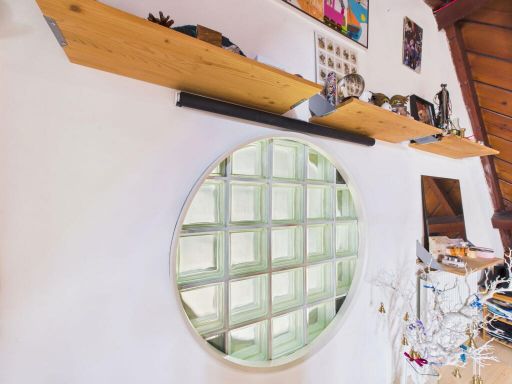
- arched window
- wooden staircase
- high ceiling
- natural light
- feature window
- heritage
- character
Nearby Schools
- Beckers Green Primary School
- Gosfield Community Primary School
- St Margaret's Preparatory School
- Richard de Clare Community Academy
- Colne Engaine Church of England Primary School
- St John the Baptist Church of England Voluntary Aided Primary School Pebmarsh
- de Vere Primary School
- St Peter's Church of England Voluntary Controlled Primary School, Coggeshall
- Great Bradfords Junior School
- Great Bradfords Infant and Nursery School
- Stisted Church of England Primary Academy
- Earls Colne Primary School and Nursery
- The Ramsey Academy, Halstead
- St Peter's Church of England Voluntary Controlled Primary School, Sible Hedingham
- The Honywood Community Science School
- Lyons Hall School
- Bocking Primary School
- St Giles' Church of England Primary School
- Hedingham School and Sixth Form
- Alec Hunter Academy
- St Francis Catholic Primary School, Braintree
- John Bunyan Primary School and Nursery
- Holy Trinity Church of England Voluntary Controlled Primary School, Halstead
- Gosfield School
- St Andrew's Church of England Primary School, Halstead
Nearest Bars And Restaurants
- Id: 346909909
- Tags:
- Amenity: pub
- Name: The Griffin
- Source: gps
- Wikidata: Q26415571
- TagsNormalized:
- Lat: 51.9422022
- Lon: 0.6409498
- FullGeoHash: u10rqxf9r0qc
- PartitionGeoHash: u10r
- Images:
- FoodStandards: null
- Distance: 220.8
,- Id: 5035326139
- Tags:
- Addr:
- City: Essex
- Country: GB
- Housenumber: 33
- Place: Halstead
- Postcode: CO9 2AA
- Street: High Street
- Amenity: restaurant
- Cuisine: thai
- Email: thai@singtong.co.uk
- Name: Singtong Thai Restaurant
- Phone: +44 1787476919
- Smoking: no
- Takeaway: yes
- Website: http://www.singtong.co.uk
- Wheelchair: yes
- TagsNormalized:
- Lat: 51.9446551
- Lon: 0.6375235
- FullGeoHash: u10rw80px3ec
- PartitionGeoHash: u10r
- Images:
- FoodStandards: null
- Distance: 174.1
,- Id: 91746671
- Tags:
- Amenity: fast_food
- Building: yes
- Name: Jubilee Chinese Foods
- TagsNormalized:
- Lat: 51.9449789
- Lon: 0.6411985
- FullGeoHash: u10rw86cmjbk
- PartitionGeoHash: u10r
- Images:
- FoodStandards: null
- Distance: 134.9
,- Id: 417201736
- Tags:
- Amenity: restaurant
- Cuisine: indian
- Name: Cinnamon Tree
- TagsNormalized:
- Lat: 51.945116
- Lon: 0.6390034
- FullGeoHash: u10rw8361z7q
- PartitionGeoHash: u10r
- Images:
- FoodStandards: null
- Distance: 130.5
,- Id: 315967449
- Tags:
- Amenity: pub
- Name: The White Hart
- Wikidata: Q26415557
- TagsNormalized:
- Lat: 51.9449161
- Lon: 0.6385614
- FullGeoHash: u10rw82cpd1y
- PartitionGeoHash: u10r
- Images:
- FoodStandards: null
- Distance: 130.2
}
Nearest General Shops
- Id: 5543980000
- Tags:
- Fixme: check on ground
- Name: WHSmith
- Shop: newsagent
- TagsNormalized:
- Lat: 51.943797
- Lon: 0.6353751
- FullGeoHash: u10rw2ndt3d4
- PartitionGeoHash: u10r
- Images:
- FoodStandards: null
- Distance: 310.6
,- Id: 4078121790
- Tags:
- Name: Lobbs Cycles
- Phone: +44 1787478888
- Service:
- Bicycle:
- Repair: yes
- Retail: yes
- Second_hand: yes
- Shop: bicycle
- TagsNormalized:
- Lat: 51.9442978
- Lon: 0.6366749
- FullGeoHash: u10rw2pt7wgj
- PartitionGeoHash: u10r
- Images:
- FoodStandards: null
- Distance: 221.3
,- Id: 8017026530
- Tags:
- Addr:
- City: Halstead
- Country: GB
- Housenumber: 1
- Postcode: CO9 2AR
- Street: Market Hill
- Alt_name: Hardys Hand Cut Tailoring
- Clothes: men
- Email: info@hardysmenswear.co.uk
- Name: Hardys Menswear
- Opening_hours: Mo-Sa 09:00-17:30
- Phone: +44 1787 477222
- Shop: clothes
- Website: http://www.hardysmenswear.com/
- TagsNormalized:
- Lat: 51.9452829
- Lon: 0.6390631
- FullGeoHash: u10rw8375nxf
- PartitionGeoHash: u10r
- Images:
- FoodStandards: null
- Distance: 145.5
}
Nearest Grocery shops
- Id: 5534464554
- Tags:
- Name: The Colne Engaine Village Shop
- Shop: convenience
- Source: GPS survey
- TagsNormalized:
- Lat: 51.9418608
- Lon: 0.6914292
- FullGeoHash: u10rrxxrr2wu
- PartitionGeoHash: u10r
- Images:
- FoodStandards: null
- Distance: 3541.8
,- Id: 1108824460
- Tags:
- Name: Co-operative
- Shop: convenience
- TagsNormalized:
- Lat: 51.9366381
- Lon: 0.6317617
- FullGeoHash: u10rqqu0c55d
- PartitionGeoHash: u10r
- Images:
- FoodStandards: null
- Distance: 997
,- Id: 316308915
- Tags:
- Name: Co-operative Food Store
- Shop: convenience
- TagsNormalized:
- Lat: 51.9447221
- Lon: 0.6417716
- FullGeoHash: u10rw85rfq58
- PartitionGeoHash: u10r
- Images:
- FoodStandards: null
- Distance: 148
}
Nearest Supermarkets
- Id: 59924608
- Tags:
- Addr:
- City: Halstead
- Country: GB
- Postcode: CO9 1HJ
- Street: Kings Road
- Brand: Lidl
- Brand:wikidata: Q151954
- Brand:wikipedia: en:Lidl
- Building: yes
- Fhrs:
- Name: Lidl
- Not:
- Shop: supermarket
- Source:
- Addr:
- Postcode: code-point_open
- Survey:
- TagsNormalized:
- Lat: 51.9428042
- Lon: 0.6342288
- FullGeoHash: u10rqrvuf8e2
- PartitionGeoHash: u10r
- Images:
- FoodStandards:
- Id: 1005736
- FHRSID: 1005736
- LocalAuthorityBusinessID: 17/00099/MIXED
- BusinessName: Lidl UK
- BusinessType: Retailers - other
- BusinessTypeID: 4613
- AddressLine1: Kings Road
- AddressLine2: Halstead
- AddressLine3: Essex
- AddressLine4: null
- PostCode: CO9 1HL
- RatingValue: 5
- RatingKey: fhrs_5_en-GB
- RatingDate: 2017-10-03
- LocalAuthorityCode: 110
- LocalAuthorityName: Braintree
- LocalAuthorityWebSite: http://www.braintree.gov.uk
- LocalAuthorityEmailAddress: food&safety@braintree.gov.uk
- Scores:
- Hygiene: 0
- Structural: 0
- ConfidenceInManagement: 0
- NewRatingPending: false
- Geocode:
- Longitude: 0.90029000000000
- Latitude: 51.89570000000000
- Distance: 412.6
,- Id: 56975679
- Tags:
- Building: yes
- Name: East of England Co-op Supermarket
- Shop: supermarket
- Source: Bing
- TagsNormalized:
- Lat: 51.9431001
- Lon: 0.6362406
- FullGeoHash: u10rqrzq3rxm
- PartitionGeoHash: u10r
- Images:
- FoodStandards: null
- Distance: 272.3
,- Id: 428889293
- Tags:
- Brand: Sainsbury's
- Brand:wikidata: Q152096
- Brand:wikipedia: en:Sainsbury's
- Name: Sainsbury's
- Shop: supermarket
- TagsNormalized:
- sainsburys
- supermarket
- shop
- Lat: 51.9444223
- Lon: 0.6364035
- FullGeoHash: u10rw2pqjq0u
- PartitionGeoHash: u10r
- Images:
- FoodStandards: null
- Distance: 241.6
}
Nearest Religious buildings
- Id: 308270635
- Tags:
- Amenity: place_of_worship
- Denomination: baptist
- Name: Halstead Baptist Church
- Religion: christian
- TagsNormalized:
- place of worship
- baptist
- church
- christian
- Lat: 51.9458969
- Lon: 0.6384345
- FullGeoHash: u10rw82yu952
- PartitionGeoHash: u10r
- Images:
- FoodStandards: null
- Distance: 225.6
,- Id: 90633175
- Tags:
- Amenity: place_of_worship
- Denomination: jehovahs_witness
- Name: Kingdom Hall of Jehovah's Witnesses
- Religion: christian
- Source: Bing
- TagsNormalized:
- place of worship
- jehovah
- jehovahs witness
- christian
- church
- Lat: 51.94496
- Lon: 0.6424441
- FullGeoHash: u10rw87c643h
- PartitionGeoHash: u10r
- Images:
- FoodStandards: null
- Distance: 201.2
,- Id: 90633179
- Tags:
- Amenity: place_of_worship
- Building: church
- Denomination: anglican
- Name: Saint Andrew's Church, Halstead
- Religion: christian
- Wikidata: Q17536294
- TagsNormalized:
- place of worship
- church
- anglican
- christian
- Lat: 51.9451053
- Lon: 0.6396537
- FullGeoHash: u10rw83f1j2q
- PartitionGeoHash: u10r
- Images:
- FoodStandards: null
- Distance: 115.6
}
Nearest Medical buildings
- Id: 900727609
- Tags:
- Addr:
- City: Halstead
- Housenumber: 78
- Postcode: CO9 2DL
- Street: Hedingham Road
- Amenity: hospital
- Name: Halstead Hospital
- TagsNormalized:
- Lat: 51.9481012
- Lon: 0.6382035
- FullGeoHash: u10rw8bex5zn
- PartitionGeoHash: u10r
- Images:
- FoodStandards: null
- Distance: 462.2
,- Id: 56954536
- Tags:
- Amenity: parking
- Capacity: 60
- Capacity:disabled: yes
- Fee: no
- Name: Elizabeth Courtauld Surgery
- Parking: surface
- TagsNormalized:
- Lat: 51.9418829
- Lon: 0.635886
- FullGeoHash: u10rqrxp3hyb
- PartitionGeoHash: u10r
- Images:
- FoodStandards: null
- Distance: 366.8
,- Id: 710906453
- Tags:
- Amenity: doctors
- Name: Elizabeth Courtauld Surgery
- TagsNormalized:
- Lat: 51.9421804
- Lon: 0.6356472
- FullGeoHash: u10rqryc5shz
- PartitionGeoHash: u10r
- Images:
- FoodStandards: null
- Distance: 358.8
,- Id: 5035326138
- Tags:
- Addr:
- City: Essex
- Country: GB
- Housename: Bank Building
- Housenumber: 2
- Place: Halstead
- Postcode: CO9 2AR
- Street: Market Hill
- Amenity: clinic
- Email: reception@halsteadphysiotherapyclinic.co.uk
- Name: Halstead Sports Injury and Physiotherapy Clinic
- Operator: Braintree, Halstead and Haverhill Sports Injury and Physiotherapy Clinic
- Phone: +44 1787478789
- Website: http://physioclinichaverhill.com
- TagsNormalized:
- clinic
- physiotherapy
- sports
- therapy
- Lat: 51.9454062
- Lon: 0.6388694
- FullGeoHash: u10rw835ytx9
- PartitionGeoHash: u10r
- Images:
- FoodStandards: null
- Distance: 163.5
}
Nearest Airports
- Id: 495488524
- Tags:
- Aerodrome: international
- Aerodrome:type: public
- Aeroway: aerodrome
- Alt_name: Stansted
- Iata: STN
- Icao: EGSS
- Is_in: Essex,England,UK
- Name: London Stansted Airport
- Ref: STN
- Source: Gagravarr_Airports
- Website: https://www.stanstedairport.com/
- Wikidata: Q8709
- Wikipedia: en:London Stansted Airport
- TagsNormalized:
- airport
- international airport
- Lat: 51.8869677
- Lon: 0.2429264
- FullGeoHash: u10pjt8zkxg4
- PartitionGeoHash: u10p
- Images:
- FoodStandards: null
- Distance: 27957
}
Nearest Leisure Facilities
- Id: 911543960
- Tags:
- Leisure: pitch
- Sport: bowls
- TagsNormalized:
- Lat: 51.9427938
- Lon: 0.6489451
- FullGeoHash: u10rqzbs9w8d
- PartitionGeoHash: u10r
- Images:
- FoodStandards: null
- Distance: 637.3
,- Id: 90633621
- Tags:
- Leisure: sports_centre
- Name: Halstead Leisure Centre
- TagsNormalized:
- sports
- sports centre
- leisure
- Lat: 51.9465293
- Lon: 0.6479024
- FullGeoHash: u10rw8xf3nzj
- PartitionGeoHash: u10r
- Images:
- FoodStandards: null
- Distance: 613.6
,- Id: 1588274863
- Tags:
- TagsNormalized:
- swimming
- swimming pool
- pool
- leisure
- Lat: 51.946535
- Lon: 0.6476909
- FullGeoHash: u10rw8xdkrcr
- PartitionGeoHash: u10r
- Images:
- FoodStandards: null
- Distance: 600.9
,- Id: 28075179
- Tags:
- Created_by: Potlatch 0.10e
- Leisure: stadium
- Name: Halstead Town Football Club
- Sport: soccer
- Wikidata: Q5643567
- TagsNormalized:
- stadium
- leisure
- football
- club
- soccer
- sports
- Lat: 51.9464843
- Lon: 0.6327039
- FullGeoHash: u10rw2sdpnd0
- PartitionGeoHash: u10r
- Images:
- FoodStandards: null
- Distance: 560.3
,- Id: 43371447
- Tags:
- TagsNormalized:
- Lat: 51.9428714
- Lon: 0.6331757
- FullGeoHash: u10rqrvj4j41
- PartitionGeoHash: u10r
- Images:
- FoodStandards: null
- Distance: 478.9
}
Nearest Tourist attractions
- Id: 832863254
- Tags:
- Building: yes
- Name: Earls Colne Heritage Museum
- Tourism: museum
- Wikidata: Q85690263
- TagsNormalized:
- Lat: 51.9269414
- Lon: 0.6959307
- FullGeoHash: u10rrv4b277w
- PartitionGeoHash: u10r
- Images:
- FoodStandards: null
- Distance: 4288.8
,- Id: 236003866
- Tags:
- Caravans: yes
- Description: tents 15th April to the 2nd October only
- Fee: yes
- Motorhomes: yes
- Name: Gosfield Lake Resort
- Opening_hours: Jan 1-Dec 31
- Shower: yes
- Tents: yes
- Toilets: yes
- Tourism: camp_site
- Website: https://gosfieldlake.co.uk/
- TagsNormalized:
- Lat: 51.9352701
- Lon: 0.5790426
- FullGeoHash: u10rmnt8usj3
- PartitionGeoHash: u10r
- Images:
- FoodStandards: null
- Distance: 4284.1
,- Id: 236003868
- Tags:
- Name: Gosfield Lake Resort
- Tourism: caravan_site
- TagsNormalized:
- Lat: 51.9344308
- Lon: 0.5834628
- FullGeoHash: u10rmq2ggxt6
- PartitionGeoHash: u10r
- Images:
- FoodStandards: null
- Distance: 4013.7
}
Nearest Train stations
- Id: 187038971
- Tags:
- Amenity: shelter
- Building: train_station
- TagsNormalized:
- shelter
- station
- train
- train station
- Lat: 51.8692466
- Lon: 0.5682988
- FullGeoHash: u10rhftb626k
- PartitionGeoHash: u10r
- Images:
- FoodStandards: null
- Distance: 9661.7
,- Id: 55420882
- Tags:
- Addr:
- Postcode: CM77 8YH
- Street: Chapel Hill Retail Park
- Name: Braintree Freeport
- Naptan:
- Network: National Rail
- Note: FIXME location approximate, judged from landsat
- Public_transport: station
- Railway: station
- Ref:
- Train: yes
- Wikidata: Q2540597
- Wikipedia: en:Braintree Freeport railway station
- TagsNormalized:
- Lat: 51.8692939
- Lon: 0.5681965
- FullGeoHash: u10rhft8xcnn
- PartitionGeoHash: u10r
- Images:
- FoodStandards: null
- Distance: 9660.8
,- Id: 187033767
- Tags:
- Amenity: cafe
- Building: train_station
- Name: Cafe Alexander
- TagsNormalized:
- cafe
- station
- train
- train station
- Lat: 51.8753588
- Lon: 0.5565999
- FullGeoHash: u10rhet7ceyb
- PartitionGeoHash: u10r
- Images:
- FoodStandards: null
- Distance: 9540.6
,- Id: 1997260503
- Tags:
- Name: Braintree
- Name:lt: Breintris
- Naptan:
- Network: National Rail
- Old_name: Braintree and Bocking
- Public_transport: station
- Railway: station
- Ref:
- Train: yes
- Wikidata: Q2716690
- Wikipedia: en:Braintree railway station (England)
- TagsNormalized:
- Lat: 51.8753105
- Lon: 0.5567303
- FullGeoHash: u10rhet7sfb0
- PartitionGeoHash: u10r
- Images:
- FoodStandards: null
- Distance: 9539.5
,- Id: 8235194539
- Tags:
- Name: Thompson Green station (MR2)
- Public_transport: station
- Railway: station
- Train: yes
- Usage: tourism
- TagsNormalized:
- Lat: 51.9250992
- Lon: 0.7609321
- FullGeoHash: u10x3kdjeh01
- PartitionGeoHash: u10x
- Images:
- FoodStandards: null
- Distance: 8562.9
}
Nearest Hotels
- Id: 3889746117
- Tags:
- Internet_access: wlan
- Internet_access:fee: no
- Name: White Hart Hotel
- Smoking: no
- Stars: 3
- Tourism: hotel
- Wikidata: Q17557267
- TagsNormalized:
- Lat: 51.8708193
- Lon: 0.6858539
- FullGeoHash: u10rpdg3mt99
- PartitionGeoHash: u10r
- Images:
- FoodStandards: null
- Distance: 8734.9
,- Id: 2340512853
- Tags:
- TagsNormalized:
- Lat: 51.9091698
- Lon: 0.6857442
- FullGeoHash: u10rr9g2ffxg
- PartitionGeoHash: u10r
- Images:
- FoodStandards: null
- Distance: 4995.4
,- Id: 314063238
- Tags:
- Amenity: pub
- Name: The Bull Hotel
- Wikidata: Q26415608
- TagsNormalized:
- Lat: 51.9433031
- Lon: 0.6348141
- FullGeoHash: u10rqryr8jx8
- PartitionGeoHash: u10r
- Images:
- FoodStandards: null
- Distance: 358
}
Tags
- Gothic Revival
- church
- chapel
- conversion opportunity
- period property
- large windows
- stone facade
- historic
- architectural interest
- Victorian
- Gothic
- arched window
- wooden staircase
- high ceiling
- natural light
- feature window
- period property
- heritage
- historic
- character
Local Market Stats
- Average Price/sqft: £329
- Avg Income: £44500
- Rental Yield: 3.6%
- Social Housing: 10%
- Planning Success Rate: 73%
Similar Properties
 3 bedroom duplex for sale in Parsonage Street, Halstead, Essex, CO9 — £400,000 • 3 bed • 2 bath • 2000 ft²
 2 bedroom apartment for sale in Trinity Street, Halstead, Essex, CO9 — £250,000 • 2 bed • 2 bath • 796 ft²
 3 bedroom detached house for sale in Pretoria Road, Halstead, CO9 — £450,000 • 3 bed • 1 bath
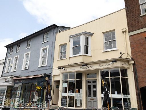 2 bedroom apartment for sale in High Street, Halstead, Essex, CO9 — £225,000 • 2 bed • 1 bath • 1052 ft²
 4 bedroom detached house for sale in Upper Chapel Street, Halstead, CO9 — £825,000 • 4 bed • 3 bath • 1727 ft²
 2 bedroom terraced house for sale in Highbury Terrace, Halstead, Essex, CO9 — £300,000 • 2 bed • 1 bath • 606 ft²
Meta
- {
"@context": "https://schema.org",
"@type": "Residence",
"name": "3 bedroom penthouse for sale in Parsonage Street, Halstead,…",
"description": "",
"url": "https://propertypiper.co.uk/property/c35bf3b9-e1b2-46cc-bf0a-4c9a0f08c8ab",
"image": "https://image-a.propertypiper.co.uk/4da10d86-478f-4b3a-a5d8-d32653834178-1024.jpeg",
"address": {
"@type": "PostalAddress",
"streetAddress": "CONGREGATION HOUSE FLAT 7 PARSONAGE STREET HALSTEAD",
"postalCode": "CO9 2JW",
"addressLocality": "Braintree",
"addressRegion": "Braintree",
"addressCountry": "England"
},
"geo": {
"@type": "GeoCoordinates",
"latitude": 51.94407579324149,
"longitude": 0.6398838639220729
},
"numberOfRooms": 3,
"numberOfBathroomsTotal": 2,
"floorSize": {
"@type": "QuantitativeValue",
"value": 1743,
"unitCode": "FTK"
},
"offers": {
"@type": "Offer",
"price": 400000,
"priceCurrency": "GBP",
"availability": "https://schema.org/InStock"
},
"additionalProperty": [
{
"@type": "PropertyValue",
"name": "Feature",
"value": "Gothic Revival"
},
{
"@type": "PropertyValue",
"name": "Feature",
"value": "church"
},
{
"@type": "PropertyValue",
"name": "Feature",
"value": "chapel"
},
{
"@type": "PropertyValue",
"name": "Feature",
"value": "conversion opportunity"
},
{
"@type": "PropertyValue",
"name": "Feature",
"value": "period property"
},
{
"@type": "PropertyValue",
"name": "Feature",
"value": "large windows"
},
{
"@type": "PropertyValue",
"name": "Feature",
"value": "stone facade"
},
{
"@type": "PropertyValue",
"name": "Feature",
"value": "historic"
},
{
"@type": "PropertyValue",
"name": "Feature",
"value": "architectural interest"
},
{
"@type": "PropertyValue",
"name": "Feature",
"value": "Victorian"
},
{
"@type": "PropertyValue",
"name": "Feature",
"value": "Gothic"
},
{
"@type": "PropertyValue",
"name": "Feature",
"value": "arched window"
},
{
"@type": "PropertyValue",
"name": "Feature",
"value": "wooden staircase"
},
{
"@type": "PropertyValue",
"name": "Feature",
"value": "high ceiling"
},
{
"@type": "PropertyValue",
"name": "Feature",
"value": "natural light"
},
{
"@type": "PropertyValue",
"name": "Feature",
"value": "feature window"
},
{
"@type": "PropertyValue",
"name": "Feature",
"value": "period property"
},
{
"@type": "PropertyValue",
"name": "Feature",
"value": "heritage"
},
{
"@type": "PropertyValue",
"name": "Feature",
"value": "historic"
},
{
"@type": "PropertyValue",
"name": "Feature",
"value": "character"
}
]
}
High Res Floorplan Images
Compatible Floorplan Images
FloorplanImages Thumbnail