RH8 0NB - 4 bedroom semidetached house for sale in Westlands Way, Oxt…
View on Property Piper
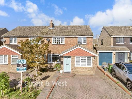
4 bedroom semi-detached house for sale in Westlands Way, Oxted, Surrey, RH8
Property Details
- Price: £495500
- Bedrooms: 4
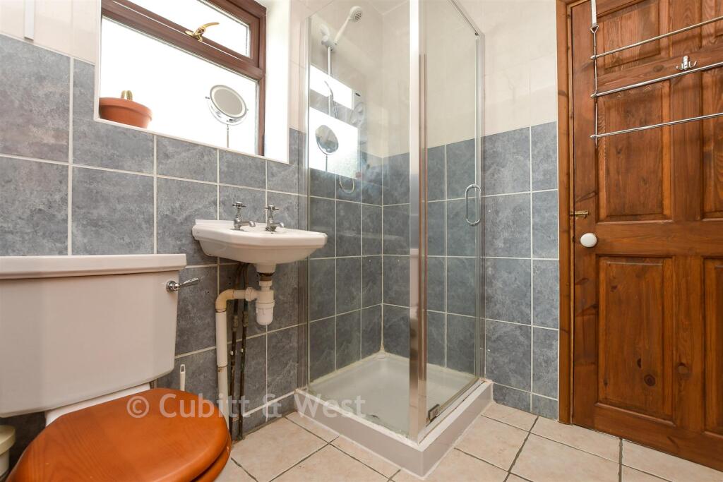
- Bathrooms: 2
- Property Type: undefined
- Property SubType: undefined
Image Descriptions
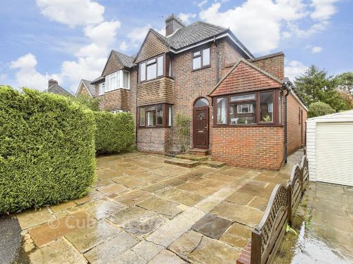
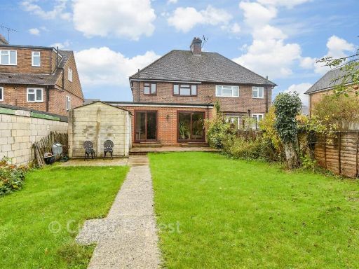
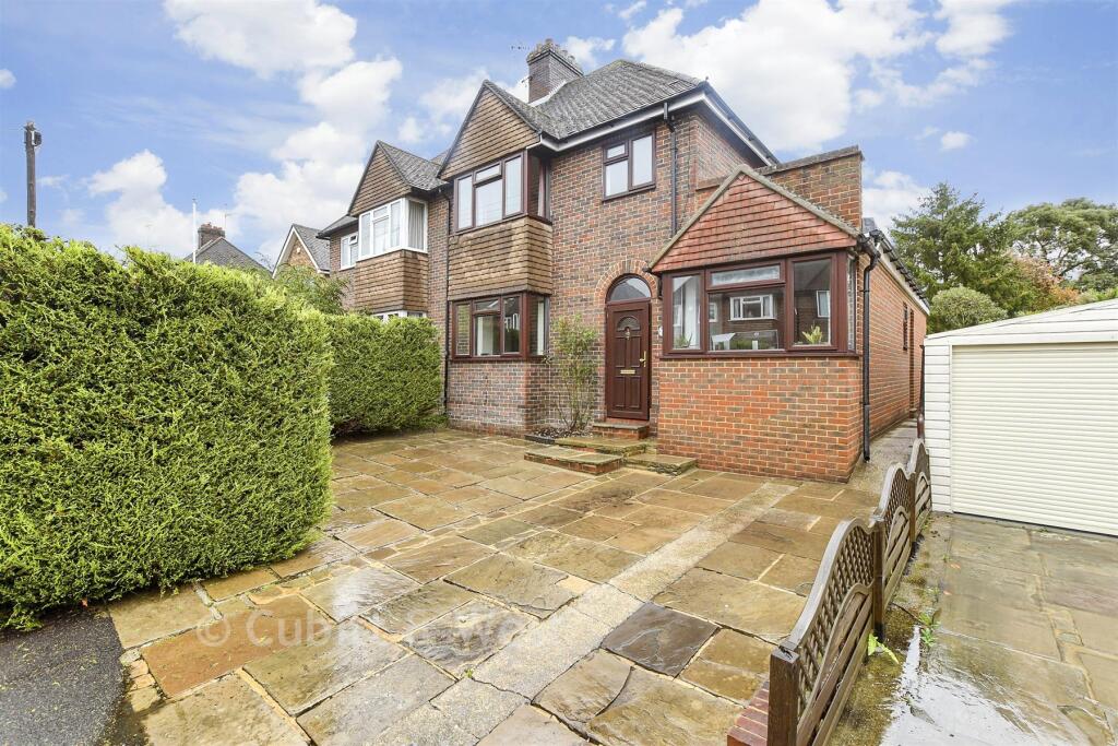
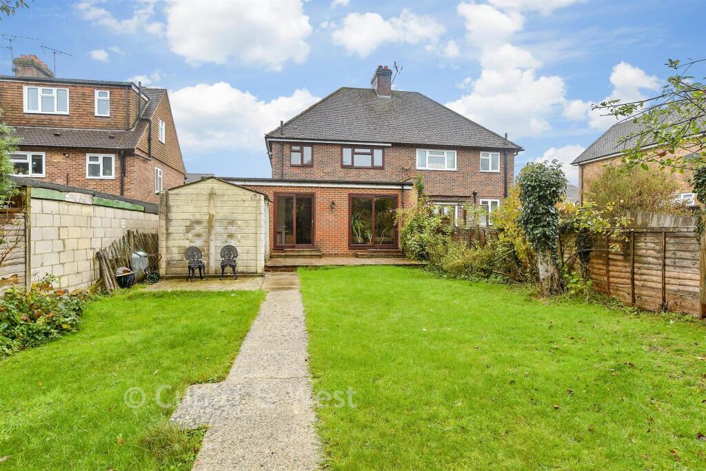
- house exterior 1930s suburban
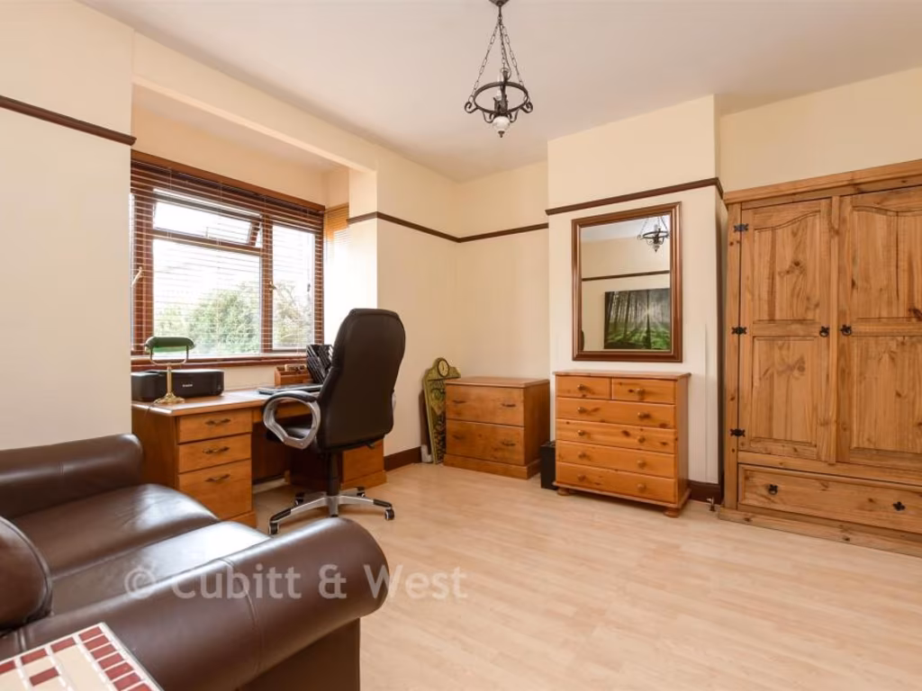
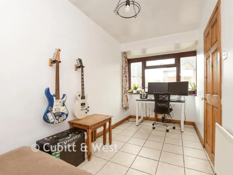
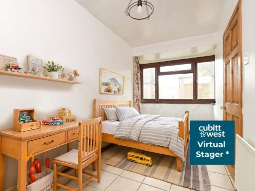
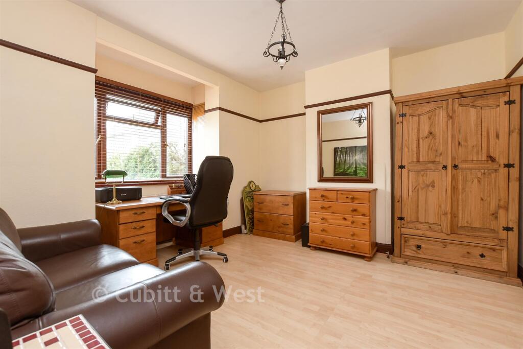
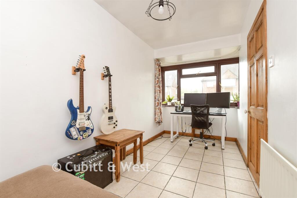
- study Traditional
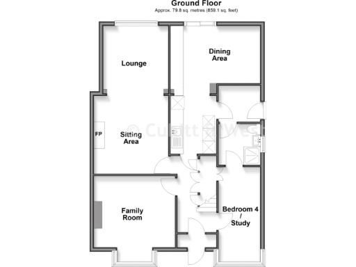
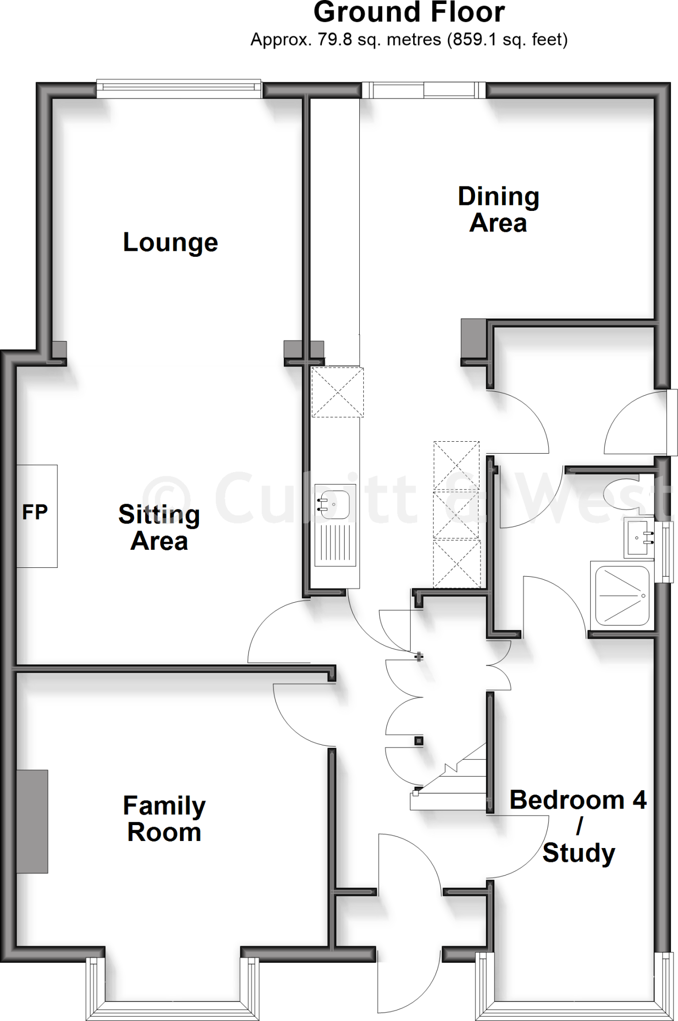
Floorplan Description
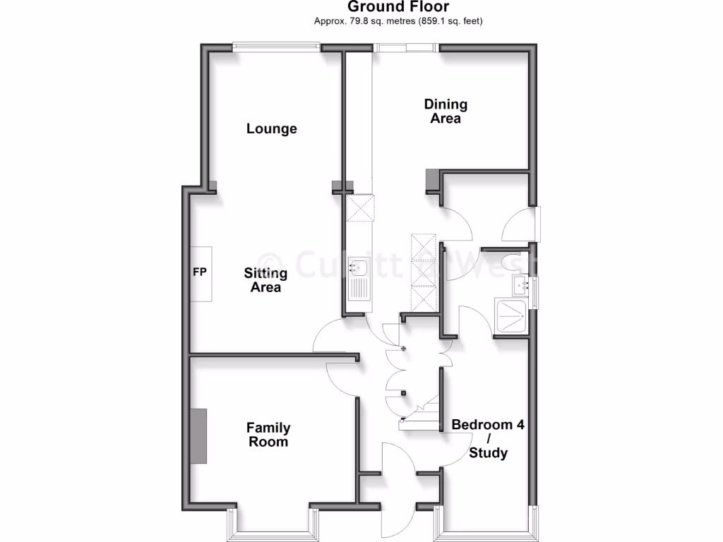
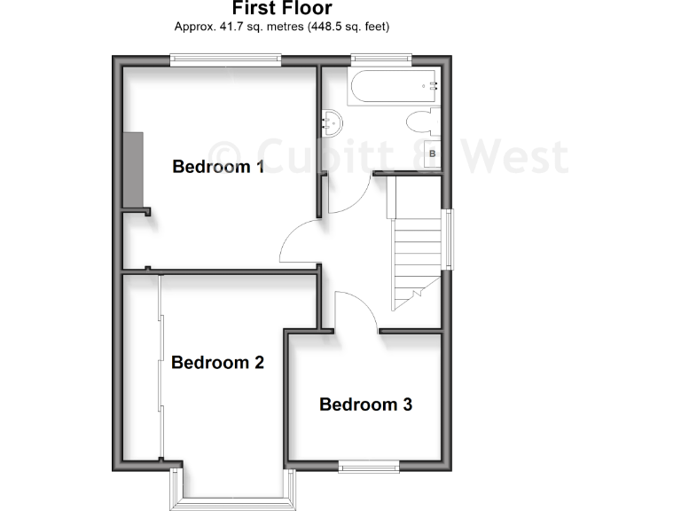
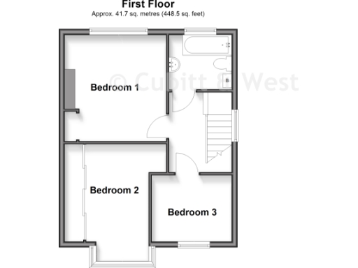
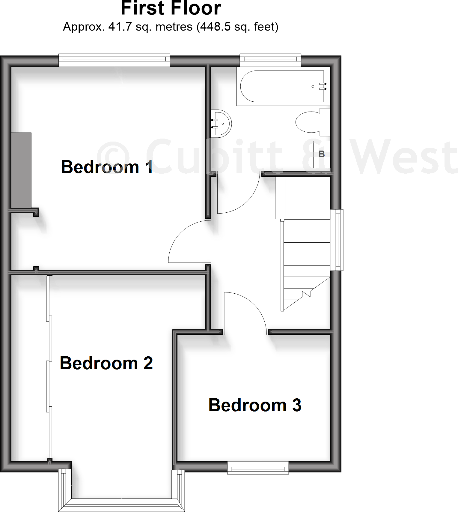
- Floorplan showing three labeled bedrooms and a bathroom/stairs area.
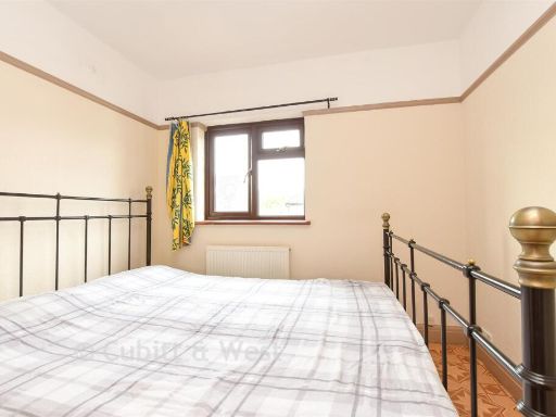
Rooms
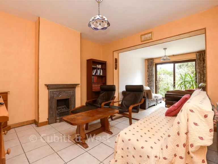
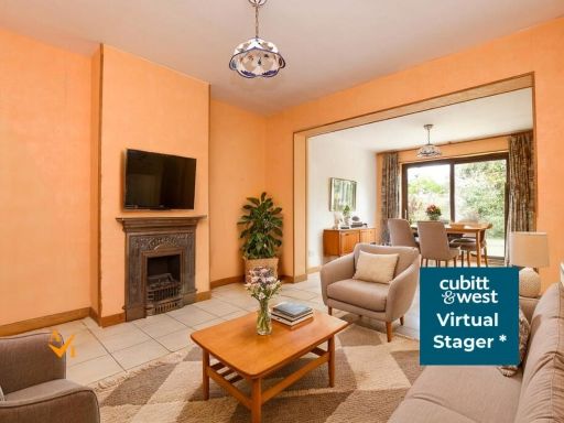
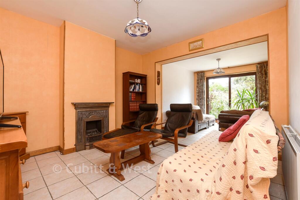
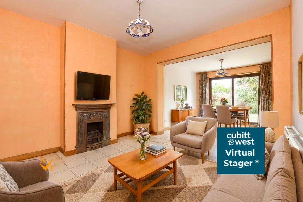
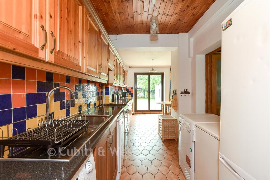
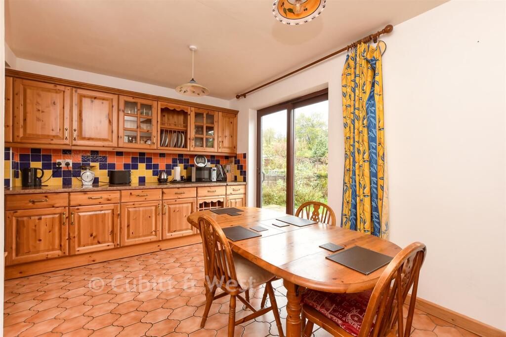
- Lounge:
- Sitting Area:
- Family Room:
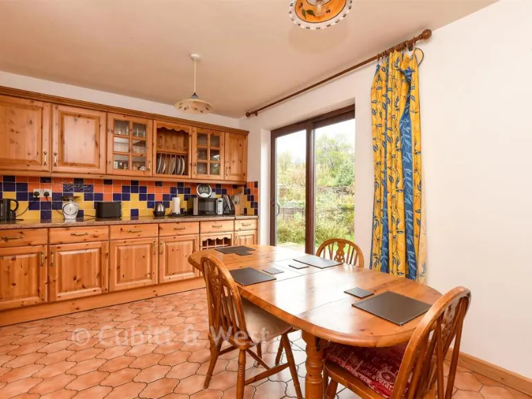
- Dining Area:
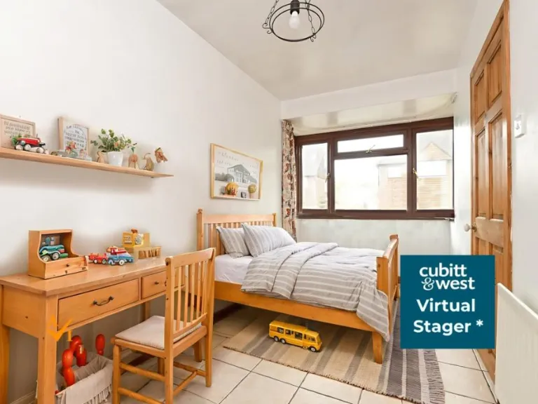
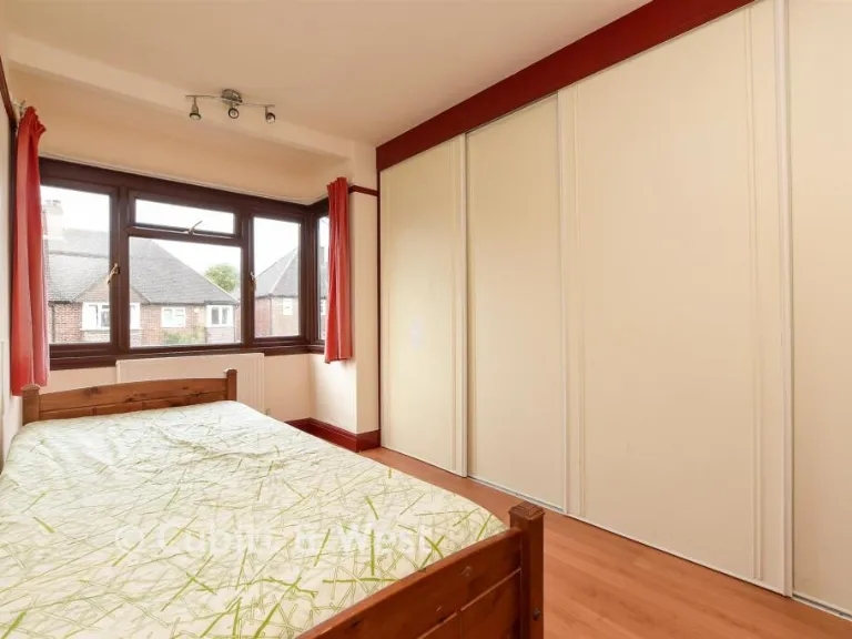
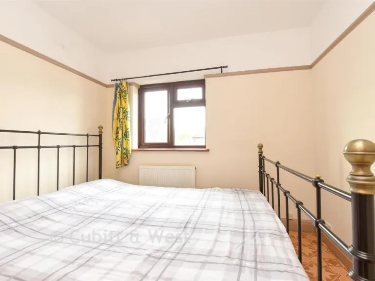
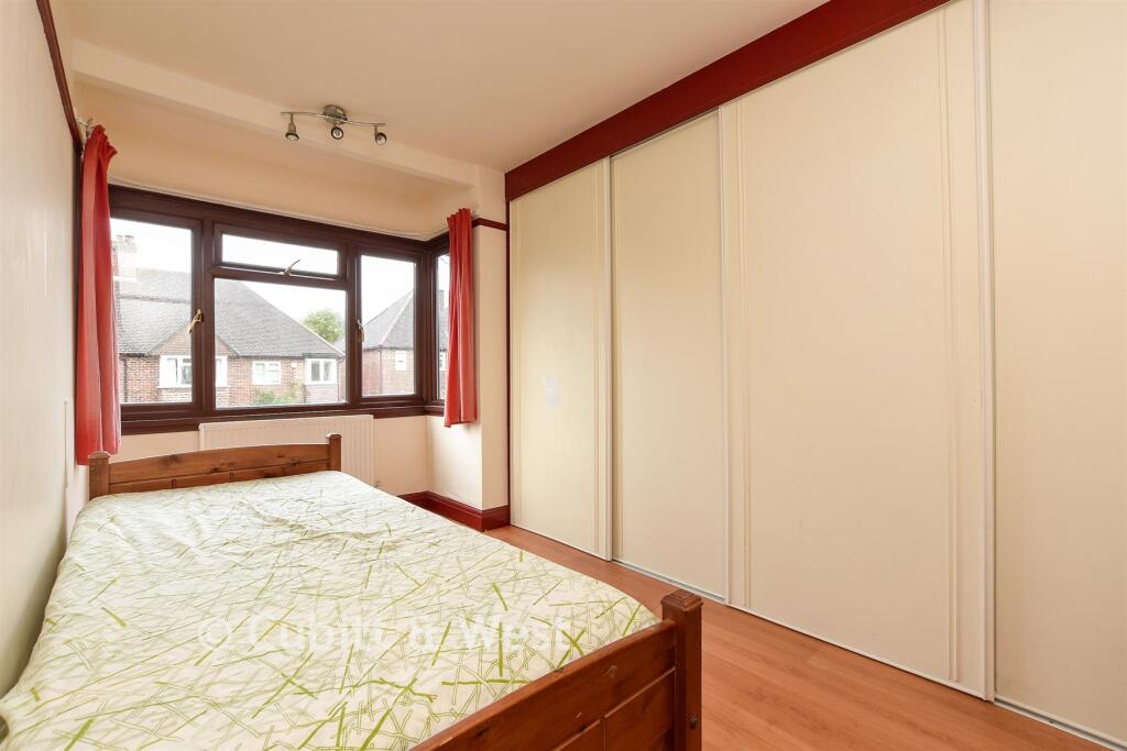
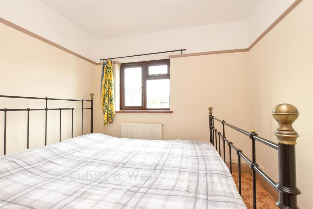
- Bedroom 4 / Study:
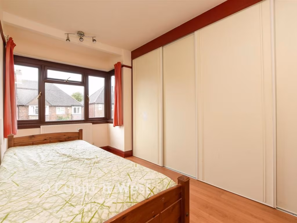
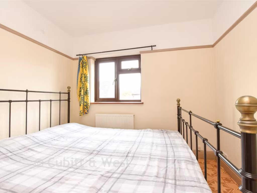
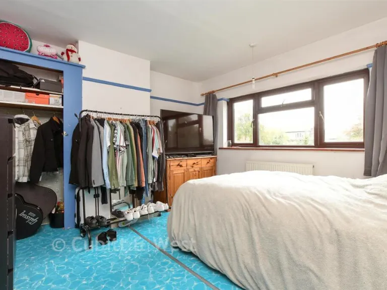
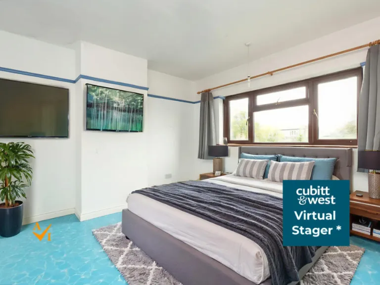
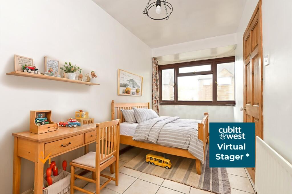
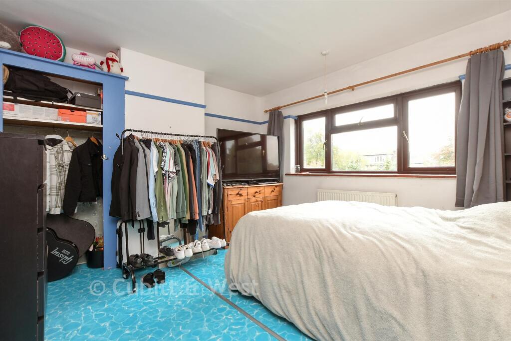
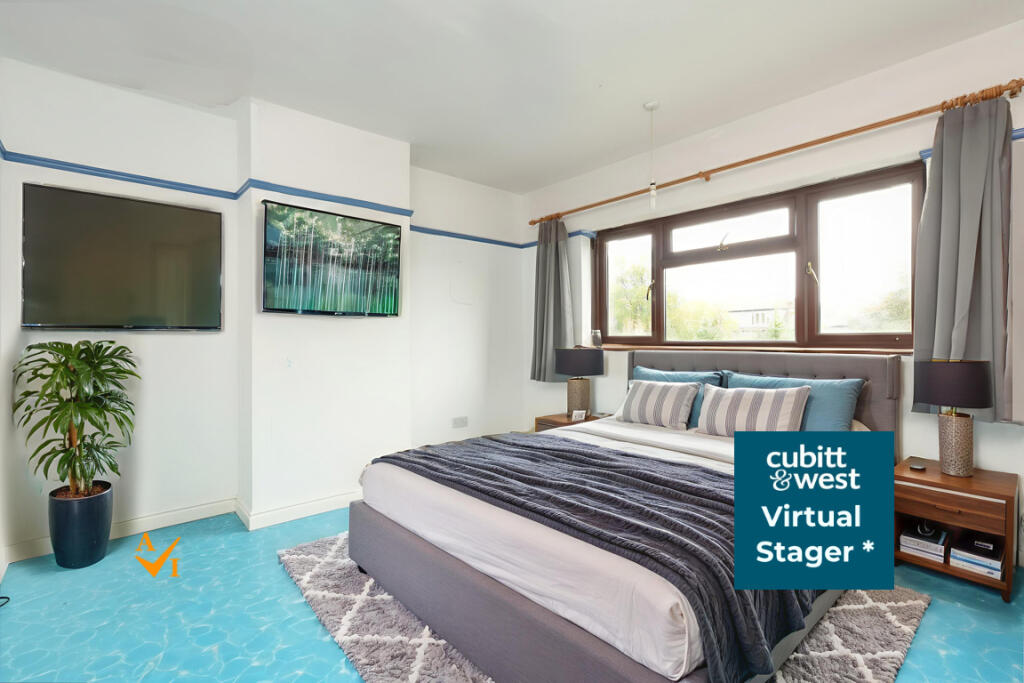
- Bedroom 1:
- Bedroom 2:
- Bedroom 3:
Textual Property Features
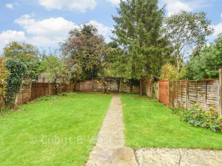
- Has Garden
- Is Retirement
- Success
Detected Visual Features
- 1930s build
- suburban
- semi-detached
- red brick
- gable roof
- bay windows
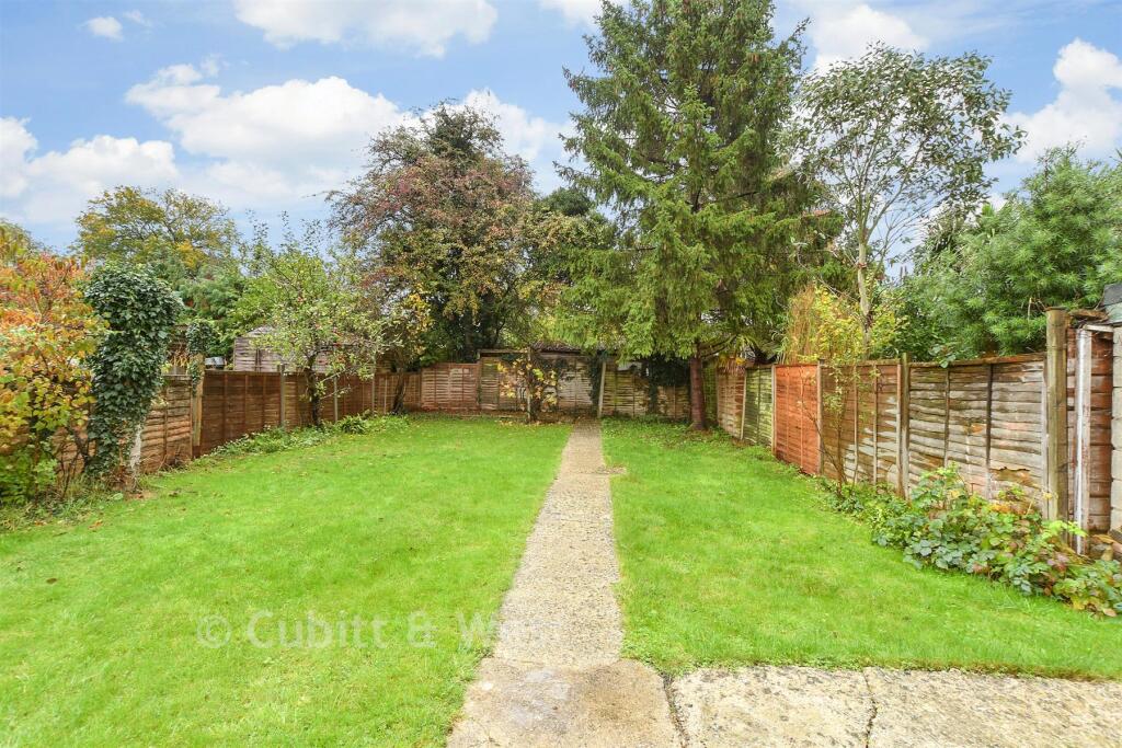
- driveway
- patio
- privacy hedge
- traditional style
- study
- large window
- double glazing
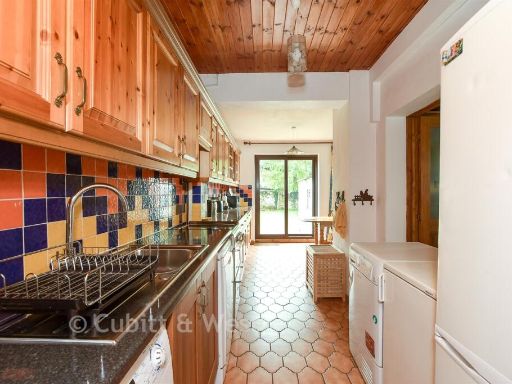
- laminate flooring
- wood paneling
- standard ceiling height
EPC Details
- Fully double glazed
- Cavity wall, filled cavity
- Boiler and radiators, mains gas
- Low energy lighting in 85% of fixed outlets
- Suspended, no insulation (assumed)
Nearby Schools
- Godstone Primary and Nursery School
- Caterham Prep
- Woodlea Primary School
- Marden Lodge Primary School and Nursery
- Hamsey Green Primary
- Meridian High School
- Fairchildes Primary School
- Hazelwood School
- Oaklands Primary Academy
- St Stephen's CofE Primary School
- Oxted School
- St John's CofE Aided Primary School
- Holland Junior School
- Limpsfield CofE Infant School
- Tatsfield Primary School
- Biggin Hill Primary School
- St Peter's CofE Infant School
- St Mary's CofE Primary School
- Caterham School
- de Stafford School
- Warlingham Village Primary School
- Warlingham School
- Woldingham School
- Essendene Lodge School
- Warlingham Park School
Nearest Bars And Restaurants
- Id: 4549327701
- Tags:
- Amenity: restaurant
- Name: Cattle & Cocktail
- TagsNormalized:
- Lat: 51.2566961
- Lon: -0.0068603
- FullGeoHash: gcpgxfgpbhsw
- PartitionGeoHash: gcpg
- Images:
- FoodStandards: null
- Distance: 1098.2
,- Id: 2619443375
- Tags:
- Addr:
- City: Oxted
- Street: Station Road West
- Amenity: cafe
- Drive_through: no
- Name: Robertsons
- Opening_hours: Mo-Su 08:30-17:00
- Outdoor_seating: no
- Phone: +44 1883 712777
- TagsNormalized:
- Lat: 51.257368
- Lon: -0.005621
- FullGeoHash: gcpgxg5gv1bw
- PartitionGeoHash: gcpg
- Images:
- FoodStandards: null
- Distance: 1081.5
,- Id: 2619445476
- Tags:
- Addr:
- City: Oxted
- Housenumber: 40
- Postcode: RH8 9EU
- Street: Station Road West
- Amenity: restaurant
- Cuisine: chinese
- Name: Golden Palace
- Outdoor_seating: no
- Phone: +44 1883 715323
- Takeaway: yes
- Wheelchair: yes
- TagsNormalized:
- restaurant
- chinese
- takeaway
- Lat: 51.257357
- Lon: -0.005672
- FullGeoHash: gcpgxg5gezfs
- PartitionGeoHash: gcpg
- Images:
- FoodStandards: null
- Distance: 1080.5
,- Id: 4427740750
- Tags:
- Addr:
- Street: Station Road West
- Amenity: cafe
- Name: Cafe Papillon
- Opening_hours: Mo-Sa 08:00-17:00; Su 09:00-14:00
- TagsNormalized:
- Lat: 51.2576362
- Lon: -0.0051339
- FullGeoHash: gcpgxghm27gv
- PartitionGeoHash: gcpg
- Images:
- FoodStandards: null
- Distance: 1077.9
,- Id: 3721528765
- Tags:
- Amenity: restaurant
- Brand:
- Cuisine: pizza
- Name: Pizza Express
- Smoking: outside
- TagsNormalized:
- Lat: 51.2585086
- Lon: -0.004613
- FullGeoHash: gcpgxgkdkw83
- PartitionGeoHash: gcpg
- Images:
- FoodStandards: null
- Distance: 1027.4
}
Nearest General Shops
- Id: 2619436594
- Tags:
- Addr:
- Name: Personality
- Phone: +44 1883 730544
- Shop: clothes
- Website: http://www.personalityfashions.co.uk/
- Wheelchair: yes
- TagsNormalized:
- Lat: 51.257781
- Lon: -0.005114
- FullGeoHash: gcpgxghq0yft
- PartitionGeoHash: gcpg
- Images:
- FoodStandards: null
- Distance: 1066.1
,- Id: 1326965134
- Tags:
- Name: The Secondhand Bookshop
- Shop: books
- TagsNormalized:
- Lat: 51.2577404
- Lon: -0.0052159
- FullGeoHash: gcpgxghjyrqe
- PartitionGeoHash: gcpg
- Images:
- FoodStandards: null
- Distance: 1065.2
,- Id: 405009220
- Tags:
- Building: yes
- Shop: car_repair
- TagsNormalized:
- Lat: 51.2587095
- Lon: -0.0062616
- FullGeoHash: gcpgxg77wh50
- PartitionGeoHash: gcpg
- Images:
- FoodStandards: null
- Distance: 935.6
}
Nearest Grocery shops
- Id: 296527757
- Tags:
- Addr:
- City: Caterham
- Housenumber: 5
- Parentstreet: Station Road
- Postcode: CR3 7DB
- Street: The Crescent
- Village: Woldingham
- Branch: Woldingham Village Stores
- Brand: One Stop
- Brand:wikidata: Q65954217
- Building: yes
- Fhrs:
- Authority: Tandridge
- Id: 105108
- Name: One Stop
- Opening_hours: Mo-Tu,Th-Fr 09:00-13:00; We 09:00-13:00; Sa 09:00-12:30; Su off
- Shop: convenience
- TagsNormalized:
- Lat: 51.2847591
- Lon: -0.0359017
- FullGeoHash: gcpgz0jg7kjb
- PartitionGeoHash: gcpg
- Images:
- FoodStandards:
- Id: 105108
- FHRSID: 105108
- LocalAuthorityBusinessID: 36024
- BusinessName: Woldingham Village Store
- BusinessType: Retailers - other
- BusinessTypeID: 4613
- AddressLine1: 5 The Crescent
- AddressLine2: Station Road
- AddressLine3: null
- AddressLine4: Woldingham
- PostCode: CR3 7DB
- RatingValue: 5
- RatingKey: fhrs_5_en-GB
- RatingDate: 2021-08-16
- LocalAuthorityCode: 313
- LocalAuthorityName: Tandridge
- LocalAuthorityWebSite: http://www.tandridge.gov.uk/
- LocalAuthorityEmailAddress: fsa_enforcement@tandridge.gov.uk
- Scores:
- Hygiene: 0
- Structural: 0
- ConfidenceInManagement: 0
- NewRatingPending: false
- Geocode:
- Longitude: -0.03616600000000
- Latitude: 51.28503900000000
- Distance: 2621.9
,- Id: 1326937698
- Tags:
- Addr:
- City: Oxted
- Country: GB
- Housenumber: 80
- Street: Station Road East
- Brand:
- Name: Cook
- Shop: frozen_food
- Website: https://www.cookfood.net/
- TagsNormalized:
- Lat: 51.2580609
- Lon: -0.00347
- FullGeoHash: gcpgxgjrz5he
- PartitionGeoHash: gcpg
- Images:
- FoodStandards: null
- Distance: 1118.2
,- Id: 4549327702
- Tags:
- Name: EM10 Express
- Shop: convenience
- TagsNormalized:
- Lat: 51.2568774
- Lon: -0.0064427
- FullGeoHash: gcpgxg52cy7z
- PartitionGeoHash: gcpg
- Images:
- FoodStandards: null
- Distance: 1095.5
}
Nearest Supermarkets
- Id: 25955608
- Tags:
- Addr:
- Housenumber: 43
- Postcode: RH8 9AE
- Street: East Hill
- Alt_name: Morrisons Oxted
- Brand: Morrisons
- Brand:wikidata: Q922344
- Brand:wikipedia: en:Morrisons
- Building: yes
- Contact:
- Website: https://my.morrisons.com/storefinder/356
- Name: Morrisons
- Shop: supermarket
- Wheelchair: yes
- TagsNormalized:
- Lat: 51.2560379
- Lon: -0.0043751
- FullGeoHash: gcpgxfuu41cx
- PartitionGeoHash: gcpg
- Images:
- FoodStandards: null
- Distance: 1252.4
,- Id: 3541981017
- Tags:
- Addr:
- City: Oxted
- Housenumber: 88
- Postcode: RH8 0QA
- Street: Station Road East
- Brand:
- Name: Sainsbury's Local
- Note: Other open times may need to be added for holidays
- Opening_hours: Mo-Su␣07:00-23:00
- Shop: supermarket
- Website: https://stores.sainsburys.co.uk/4137/oxted-local
- TagsNormalized:
- sainsburys
- sainsburys local
- supermarket
- shop
- Lat: 51.2581828
- Lon: -0.0037508
- FullGeoHash: gcpgxgm289g4
- PartitionGeoHash: gcpg
- Images:
- FoodStandards: null
- Distance: 1094.9
,- Id: 3541894782
- Tags:
- Addr:
- City: Oxted
- Housenumber: 159
- Postcode: RH8 0QE
- Street: Station Road East
- Brand:
- Name: Waitrose
- Operator: Waitrose & Partners
- Phone: +44 1883 715740
- Shop: supermarket
- Website: https://www.waitrose.com/bf_home/bf/838.html
- TagsNormalized:
- Lat: 51.2586579
- Lon: -0.0047702
- FullGeoHash: gcpgxgke2f7h
- PartitionGeoHash: gcpg
- Images:
- FoodStandards: null
- Distance: 1007.8
}
Nearest Religious buildings
- Id: 1225642569
- Tags:
- Amenity: place_of_worship
- Denomination: united_reformed
- Name: Oxted URC
- Religion: christian
- Source: OS_OpenData_StreetView
- TagsNormalized:
- place of worship
- united reformed
- christian
- church
- Lat: 51.2601716
- Lon: -0.0033937
- FullGeoHash: gcpgxgts0ut6
- PartitionGeoHash: gcpg
- Images:
- FoodStandards: null
- Distance: 967.8
,- Id: 1225642602
- Tags:
- Amenity: place_of_worship
- Denomination: roman_catholic
- Name: All Saints'
- Religion: christian
- Source: OS_OpenData_StreetView
- Wikidata: Q20055642
- TagsNormalized:
- place of worship
- catholic
- roman catholic
- christian
- church
- Lat: 51.26082
- Lon: -0.0042226
- FullGeoHash: gcpgxgszvt7q
- PartitionGeoHash: gcpg
- Images:
- FoodStandards: null
- Distance: 879.1
,- Id: 106539708
- Tags:
- Amenity: place_of_worship
- Building: yes
- Denomination: anglican
- Name: Saint Mary's
- Religion: christian
- Source: Bing
- Wikidata: Q17527736
- TagsNormalized:
- place of worship
- anglican
- christian
- church
- Lat: 51.2590784
- Lon: -0.0086765
- FullGeoHash: gcpgxg3tvbf2
- PartitionGeoHash: gcpg
- Images:
- FoodStandards: null
- Distance: 805.7
}
Nearest Medical buildings
- Id: 8384035577
- Tags:
- Amenity: hospital
- Healthcare: hospital
- Name: Oxted Health Center
- TagsNormalized:
- Lat: 51.2576629
- Lon: -0.0000597
- FullGeoHash: gcpgxgpvw8gm
- PartitionGeoHash: gcpg
- Images:
- FoodStandards: null
- Distance: 1322.5
,- Id: 1326937624
- Tags:
- Addr:
- City: Oxted
- Housenumber: 22
- Postcode: RH8 0PG
- Street: Station Road East
- Amenity: pharmacy
- Dispensing: yes
- Healthcare: pharmacy
- Name: Paydens Ltd
- Opening_hours: Mo-Fr 09:00-18:30; Sa 09:00-17:30
- Website: http://www.paydens.com/pharmacy.asp?id=62
- TagsNormalized:
- Lat: 51.2574048
- Lon: -0.0014643
- FullGeoHash: gcpgxgnujbu1
- PartitionGeoHash: gcpg
- Images:
- FoodStandards: null
- Distance: 1268.7
,- Id: 6351231169
- Tags:
- Addr:
- City: Oxted
- Housenumber: 42A
- Postcode: RH8 0PG
- Street: Station Road East
- Amenity: dentist
- Healthcare: dentist
- Name: Pipers Dental Practice
- Phone: +44 1883 712486
- Website: http://www.pipersdentalpractice.co.uk/
- TagsNormalized:
- dentist
- health
- healthcare
- dental
- Lat: 51.2577885
- Lon: -0.0019145
- FullGeoHash: gcpgxgnw72k6
- PartitionGeoHash: gcpg
- Images:
- FoodStandards: null
- Distance: 1216.6
,- Id: 6351231159
- Tags:
- Addr:
- City: Oxted
- Housenumber: 48
- Postcode: RH8 0PG
- Street: Station Road East
- Amenity: pharmacy
- Brand: Boots
- Brand:wikidata: Q6123139
- Brand:wikipedia: en:Boots UK
- Dispensing: yes
- Healthcare: pharmacy
- Name: Boots
- Opening_hours: Mo-Sa 08:30-18:00; Su 10:00 - 16:00
- Website: https://www.boots.com/stores/1433-oxted-station-road-east-rh8-0pg
- TagsNormalized:
- pharmacy
- boots
- health
- healthcare
- Lat: 51.2577407
- Lon: -0.0022338
- FullGeoHash: gcpgxgnmgzqm
- PartitionGeoHash: gcpg
- Images:
- FoodStandards: null
- Distance: 1204.2
}
Nearest Airports
- Id: 260720166
- Tags:
- Aerodrome: international
- Aeroway: aerodrome
- Alt_name: Gatwick Airport
- Ele: 62
- Iata: LGW
- Icao: EGKK
- Internet_access: wlan
- Internet_access:fee: no
- Internet_access:ssid: Gatwick FREE Wi-Fi
- Name: London Gatwick Airport
- Operator: Gatwick Airport Limited
- Ref: LGW
- Website: https://www.gatwickairport.com/
- Wikidata: Q8703
- Wikipedia: en:Gatwick Airport
- TagsNormalized:
- airport
- international airport
- Lat: 51.1540917
- Lon: -0.1883773
- FullGeoHash: gcpg58qf4mzd
- PartitionGeoHash: gcpg
- Images:
- FoodStandards: null
- Distance: 17301.2
,- Id: 14001268
- Tags:
- Access: yes
- Aerodrome: international
- Aerodrome:type: public
- Aeroway: aerodrome
- Alt_name: London Heathrow
- Alt_name_2: London Heathrow Airport
- Ele: 25
- Iata: LHR
- Icao: EGLL
- Int_name: Heathrow Airport
- Name: London Heathrow Airport
- Note: area still approx
- Old_name: London Airport
- Operator: Heathrow Airport Limited
- Rank_aci:
- Ref: LHR
- Short_name: Heathrow
- Type: multipolygon
- Website: https://www.heathrow.com/
- Wikidata: Q8691
- Wikipedia: en:Heathrow Airport
- TagsNormalized:
- airport
- international airport
- Lat: 51.4677522
- Lon: -0.4547736
- FullGeoHash: gcpsv9kv7h2h
- PartitionGeoHash: gcps
- Images:
- FoodStandards: null
- Distance: 37953
}
Nearest Leisure Facilities
- Id: 1024253904
- Tags:
- TagsNormalized:
- Lat: 51.2657976
- Lon: -0.014527
- FullGeoHash: gcpgxstkvmrf
- PartitionGeoHash: gcpg
- Images:
- FoodStandards: null
- Distance: 57.5
,- Id: 1024253905
- Tags:
- TagsNormalized:
- Lat: 51.2656997
- Lon: -0.0144926
- FullGeoHash: gcpgxstkq71d
- PartitionGeoHash: gcpg
- Images:
- FoodStandards: null
- Distance: 47.3
,- Id: 1024253906
- Tags:
- TagsNormalized:
- Lat: 51.2656094
- Lon: -0.0144652
- FullGeoHash: gcpgxst7yfjz
- PartitionGeoHash: gcpg
- Images:
- FoodStandards: null
- Distance: 38.2
,- Id: 1024253907
- Tags:
- TagsNormalized:
- Lat: 51.2655009
- Lon: -0.0144607
- FullGeoHash: gcpgxst7pn12
- PartitionGeoHash: gcpg
- Images:
- FoodStandards: null
- Distance: 27.3
,- Id: 1024253900
- Tags:
- TagsNormalized:
- Lat: 51.2654164
- Lon: -0.0144321
- FullGeoHash: gcpgxst6xwq8
- PartitionGeoHash: gcpg
- Images:
- FoodStandards: null
- Distance: 20.9
}
Nearest Tourist attractions
- Id: 9878510108
- Tags:
- TagsNormalized:
- Lat: 51.2732126
- Lon: 0.038597
- FullGeoHash: u1058yh057s4
- PartitionGeoHash: u105
- Images:
- FoodStandards: null
- Distance: 3807.7
,- Id: 715694321
- Tags:
- Name: Beaver Water World
- Opening_hours: Closed down
- Tourism: zoo
- TagsNormalized:
- Lat: 51.2891627
- Lon: 0.0173499
- FullGeoHash: u105b2uth2ch
- PartitionGeoHash: u105
- Images:
- FoodStandards: null
- Distance: 3464.5
,- Id: 5399689350
- Tags:
- Historic: manor
- Name: Titsey Place
- Place: isolated_dwelling
- Tourism: attraction
- Website: https://www.titsey.org
- Wikidata: Q7810234
- TagsNormalized:
- Lat: 51.2773222
- Lon: 0.0158952
- FullGeoHash: u1058qg843sm
- PartitionGeoHash: u105
- Images:
- FoodStandards: null
- Distance: 2511.2
}
Nearest Hotels
- Id: 4336529865
- Tags:
- Name: The Kings Arms
- Tourism: hotel
- Wikidata: Q26536690
- TagsNormalized:
- Lat: 51.2669621
- Lon: 0.0713177
- FullGeoHash: u1059sggty6m
- PartitionGeoHash: u105
- Images:
- FoodStandards: null
- Distance: 5984
,- Id: 138836898
- Tags:
- Addr:
- City: Whyteleafe
- Housenumber: 431
- Postcode: CR3 0BL
- Street: Godstone Road
- Brand: Travelodge
- Brand:wikidata: Q9361374
- Brand:wikipedia: en:Travelodge UK
- Building: yes
- Fhrs:
- Internet_access: wlan
- Internet_access:fee: customers
- Internet_access:ssid: Travelodge WiFi
- Name: Travelodge Whyteleafe Caterham
- Operator: Travelodge
- Source:
- Tourism: hotel
- TagsNormalized:
- Lat: 51.3021636
- Lon: -0.0749551
- FullGeoHash: gcpgy732v2mq
- PartitionGeoHash: gcpg
- Images:
- FoodStandards: null
- Distance: 5865.7
,- Id: 220970100
- Tags:
- Addr:
- Postcode: TN16 2ER
- Street: Clacket Lane Motorway Service Area, M25 Westbound
- Brand: Days Inn
- Brand:wikidata: Q1047239
- Brand:wikipedia: en:Days Inn
- Building: yes
- Internet_access: yes
- Name: Days Inn
- Operator: Roadchef
- Tourism: hotel
- TagsNormalized:
- Lat: 51.2709593
- Lon: 0.0388759
- FullGeoHash: u1058vs6czec
- PartitionGeoHash: u105
- Images:
- FoodStandards: null
- Distance: 3776.9
}
Tags
- 1930s build
- suburban
- semi-detached
- red brick
- gable roof
- bay windows
- driveway
- patio
- privacy hedge
- traditional style
- study
- large window
- double glazing
- laminate flooring
- wood paneling
- standard ceiling height
Local Market Stats
- Average Price/sqft: £505
- Avg Income: £63600
- Rental Yield: 3.5%
- Social Housing: 4%
- Planning Success Rate: 85%
Similar Properties
 4 bedroom semi-detached house for sale in Erica Way, Horsham, West Sussex, RH12 — £330,500 • 4 bed • 1 bath • 975 ft²
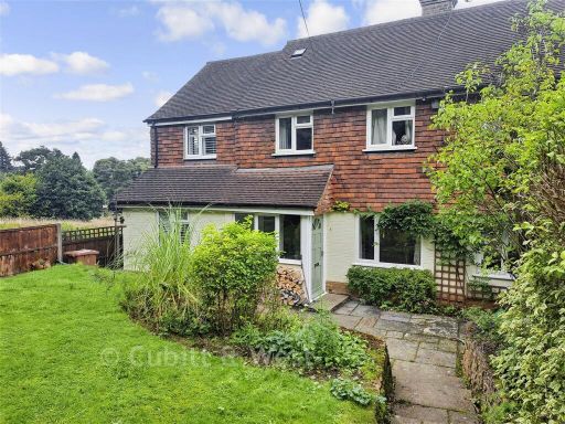 4 bedroom semi-detached house for sale in Felday Houses, Holmbury St Mary, Dorking, Surrey, RH5 — £462,500 • 4 bed • 2 bath • 1160 ft²
 3 bedroom detached house for sale in Cronks Hill Close, Redhill, Surrey, RH1 — £479,000 • 3 bed • 1 bath • 997 ft²
 3 bedroom semi-detached house for sale in Shirley Avenue, Redhill, Surrey, RH1 — £297,500 • 3 bed • 1 bath • 797 ft²
 4 bedroom terraced house for sale in Main Road, Edenbridge, Kent, TN8 — £330,500 • 4 bed • 3 bath • 1368 ft²
 4 bedroom detached house for sale in Copthill Lane, Kingswood, Surrey, KT20 — £792,500 • 4 bed • 2 bath • 2000 ft²
Meta
- {
"@context": "https://schema.org",
"@type": "Residence",
"name": "4 bedroom semidetached house for sale in Westlands Way, Oxt…",
"description": "",
"url": "https://propertypiper.co.uk/property/ab370204-e936-44e7-822a-64147d173326",
"image": "https://image-a.propertypiper.co.uk/cb69dbe2-4fc0-4a43-9031-7eb6ab92d940-1024.jpeg",
"address": {
"@type": "PostalAddress",
"streetAddress": "CHARTERIDGE, WESTLANDS WAY, OXTED",
"postalCode": "RH8 0NB",
"addressLocality": "Tandridge",
"addressRegion": "East Surrey",
"addressCountry": "England"
},
"geo": {
"@type": "GeoCoordinates",
"latitude": 51.265285804501104,
"longitude": -0.014648516438572259
},
"numberOfRooms": 4,
"numberOfBathroomsTotal": 2,
"floorSize": {
"@type": "QuantitativeValue",
"value": 1755,
"unitCode": "FTK"
},
"offers": {
"@type": "Offer",
"price": 495500,
"priceCurrency": "GBP",
"availability": "https://schema.org/InStock"
},
"additionalProperty": [
{
"@type": "PropertyValue",
"name": "Feature",
"value": "1930s build"
},
{
"@type": "PropertyValue",
"name": "Feature",
"value": "suburban"
},
{
"@type": "PropertyValue",
"name": "Feature",
"value": "semi-detached"
},
{
"@type": "PropertyValue",
"name": "Feature",
"value": "red brick"
},
{
"@type": "PropertyValue",
"name": "Feature",
"value": "gable roof"
},
{
"@type": "PropertyValue",
"name": "Feature",
"value": "bay windows"
},
{
"@type": "PropertyValue",
"name": "Feature",
"value": "driveway"
},
{
"@type": "PropertyValue",
"name": "Feature",
"value": "patio"
},
{
"@type": "PropertyValue",
"name": "Feature",
"value": "privacy hedge"
},
{
"@type": "PropertyValue",
"name": "Feature",
"value": "traditional style"
},
{
"@type": "PropertyValue",
"name": "Feature",
"value": "study"
},
{
"@type": "PropertyValue",
"name": "Feature",
"value": "large window"
},
{
"@type": "PropertyValue",
"name": "Feature",
"value": "double glazing"
},
{
"@type": "PropertyValue",
"name": "Feature",
"value": "laminate flooring"
},
{
"@type": "PropertyValue",
"name": "Feature",
"value": "wood paneling"
},
{
"@type": "PropertyValue",
"name": "Feature",
"value": "standard ceiling height"
}
]
}
High Res Floorplan Images
Compatible Floorplan Images
FloorplanImages Thumbnail