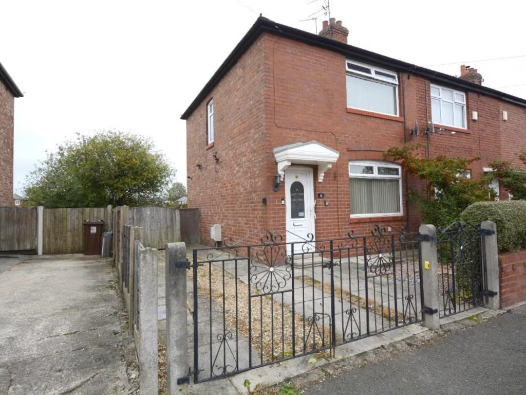
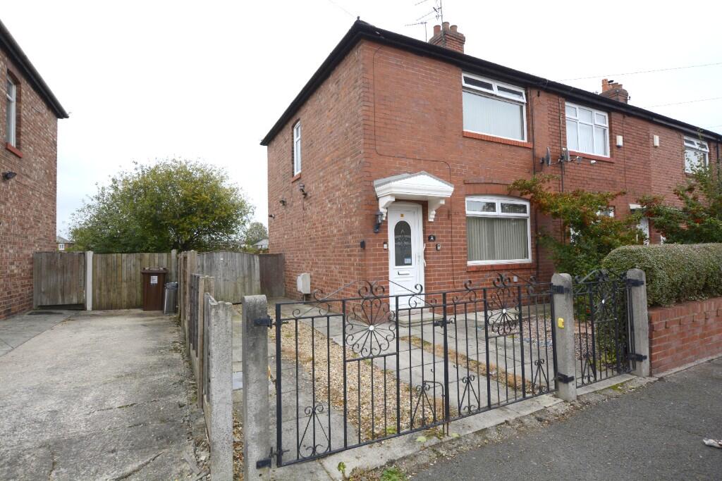
M34 3HH - 2 bedroom semidetached house for sale in York Road, Denton,…
View on Property Piper
2 bedroom semi-detached house for sale in York Road, Denton, M34
Property Details
- Price: £180000
- Bedrooms: 2
- Bathrooms: 1
- Property Type: undefined
- Property SubType: undefined
Image Descriptions
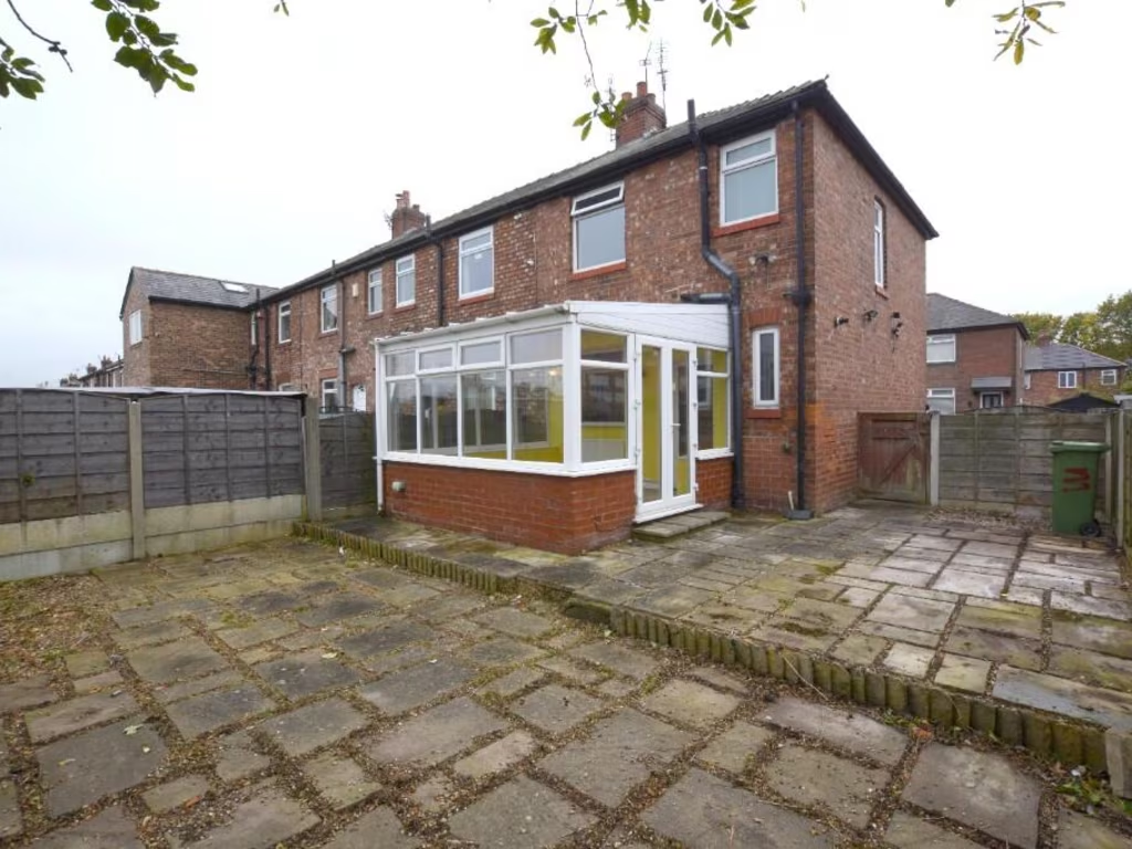
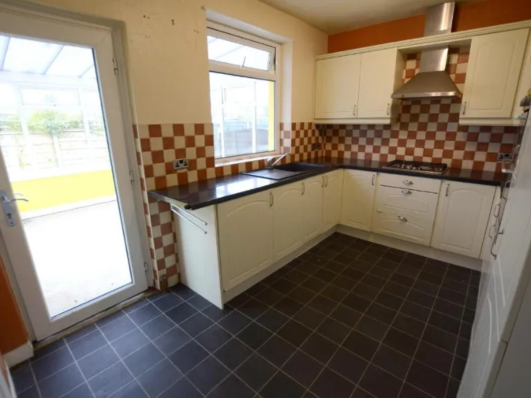
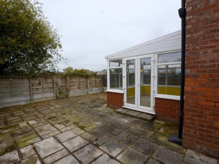
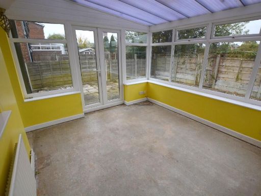
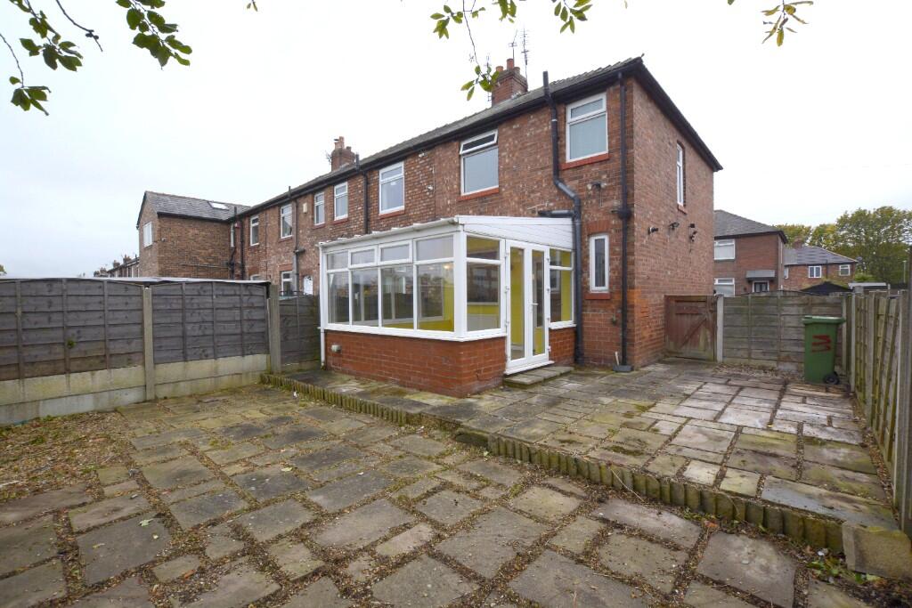
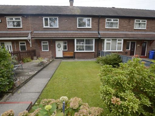
- exterior of a semi-detached house post-war traditional
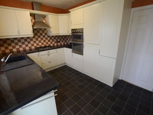
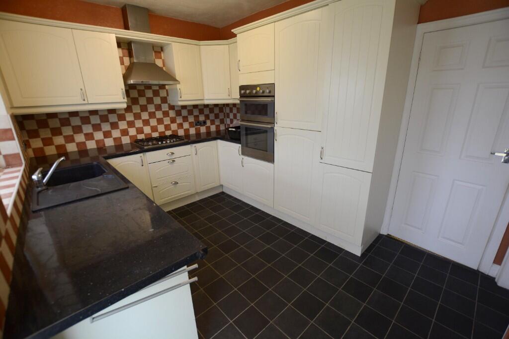
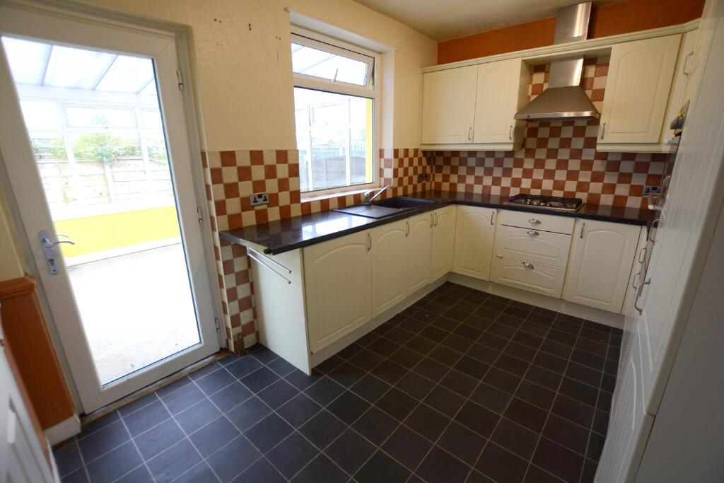
- kitchen contemporary
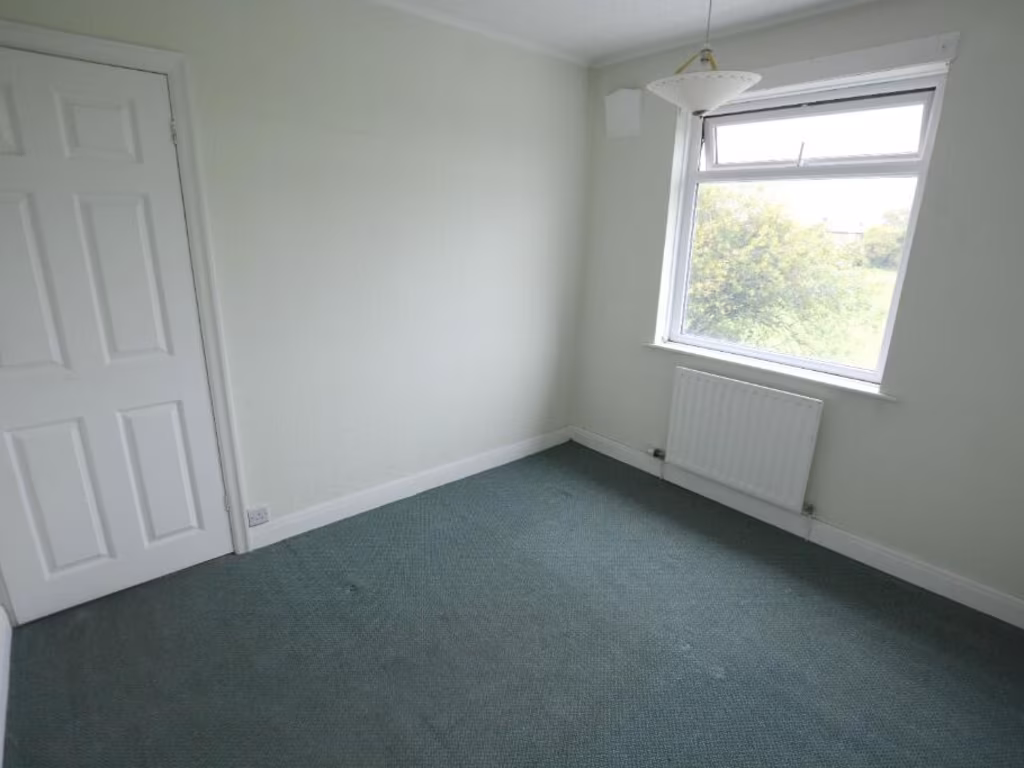
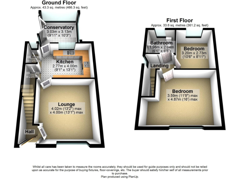
Rooms
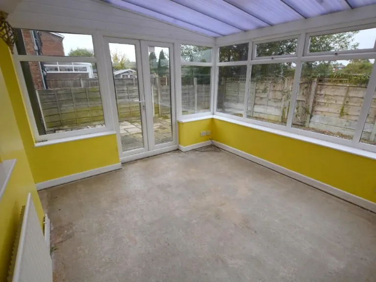
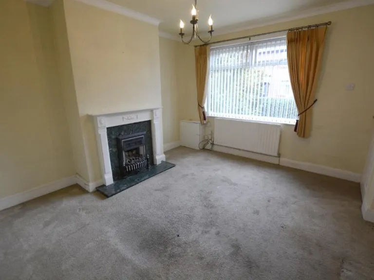
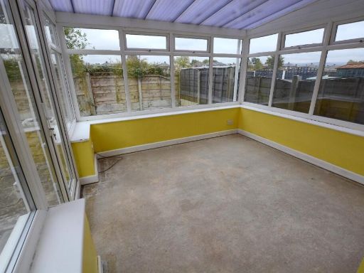
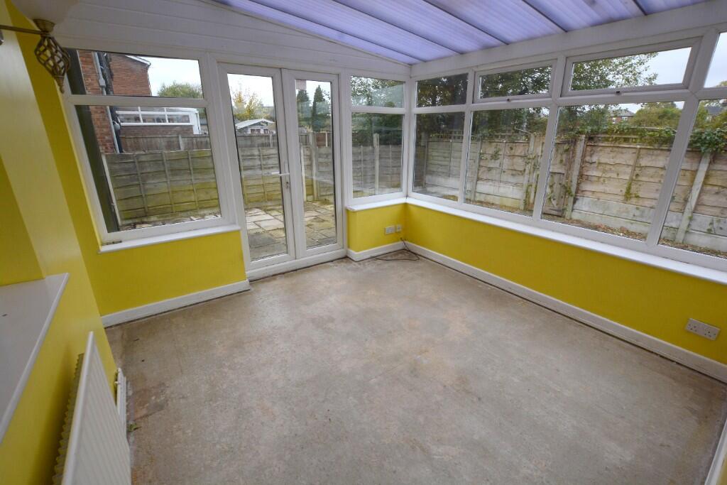
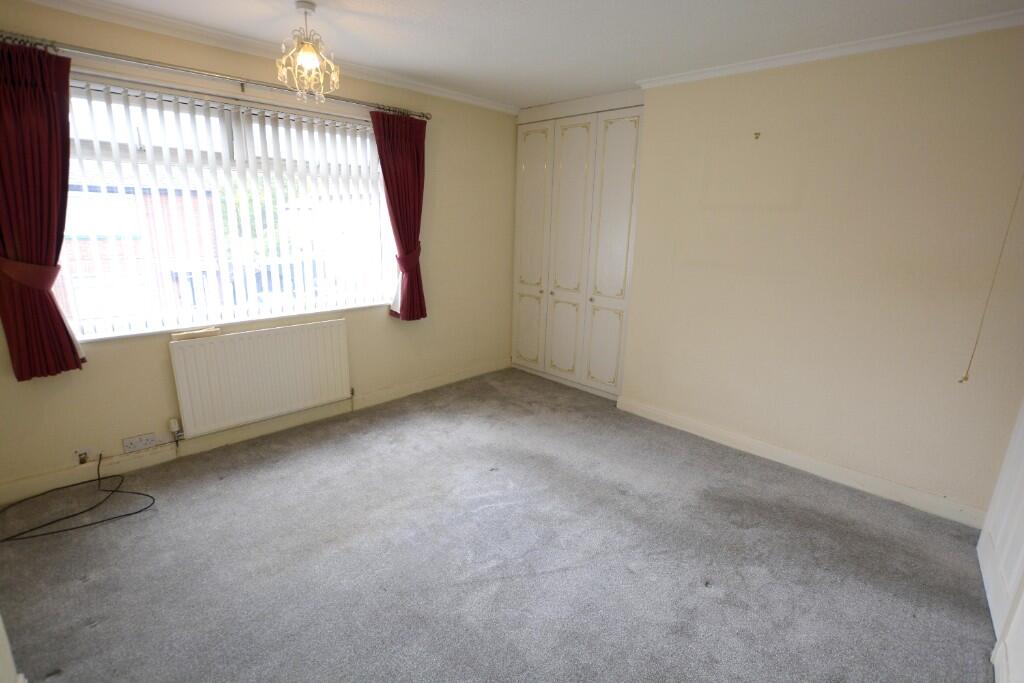
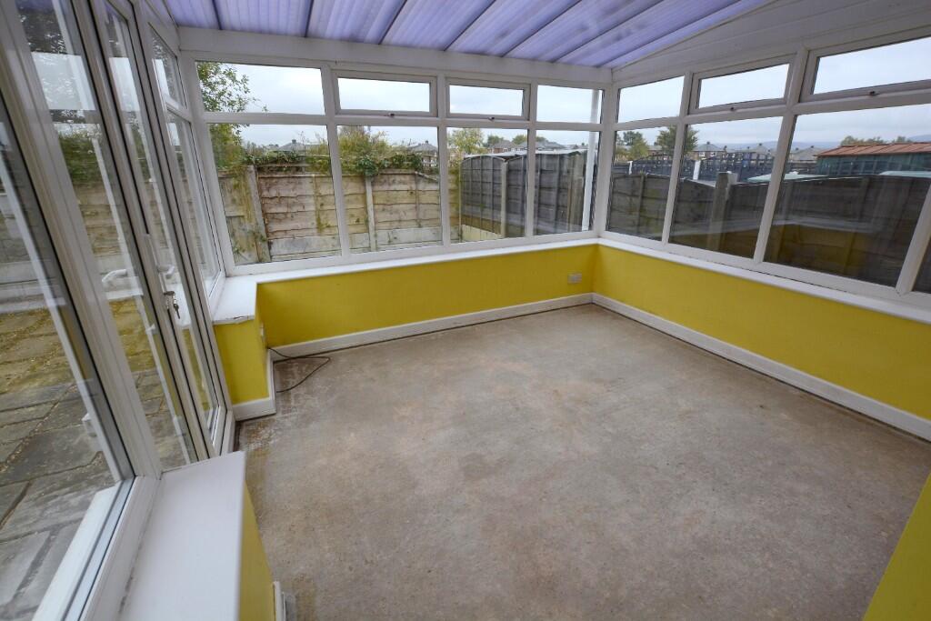
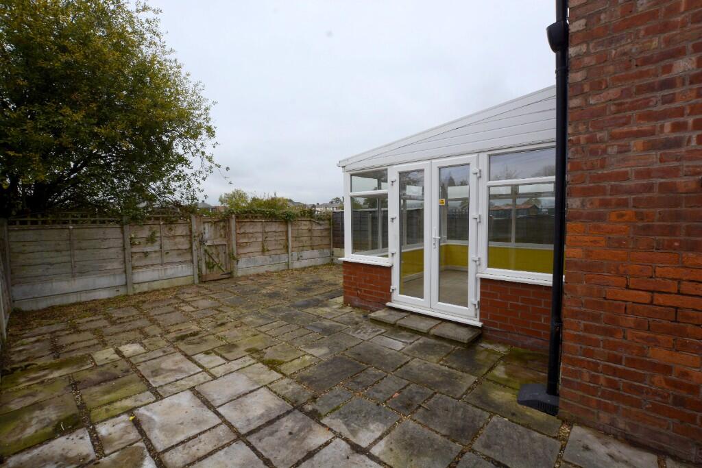
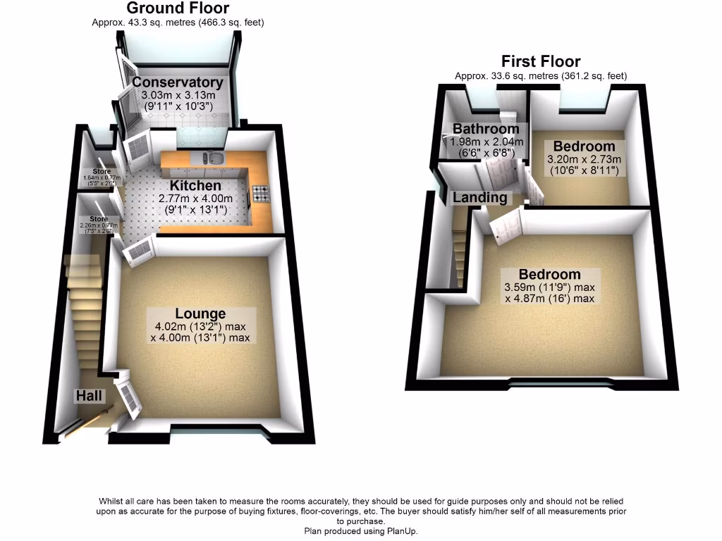
- Conservatory:
- Kitchen:
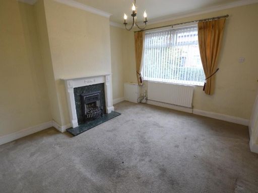
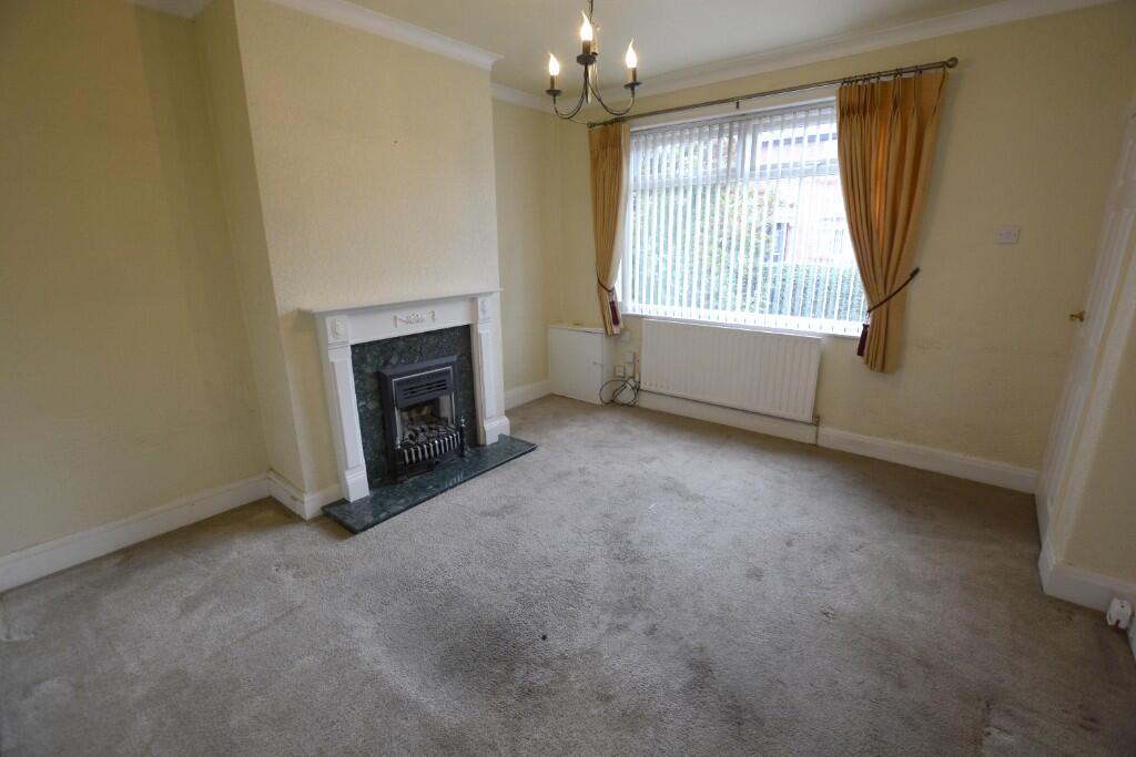
- Lounge:
- Store:
- Store:
- Hall:
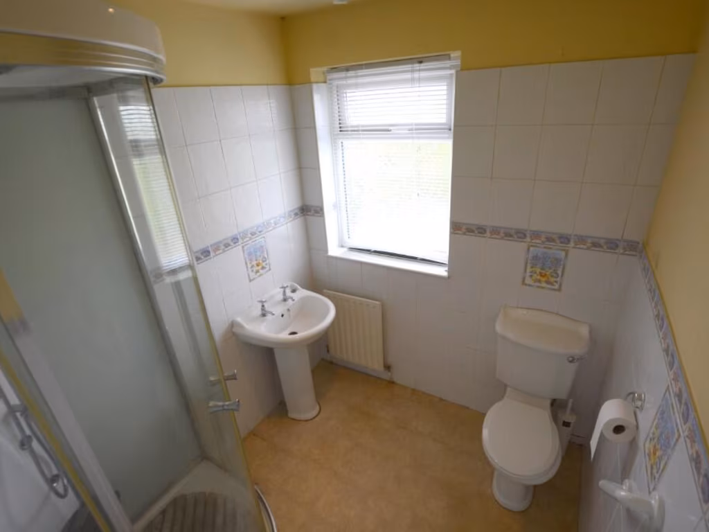
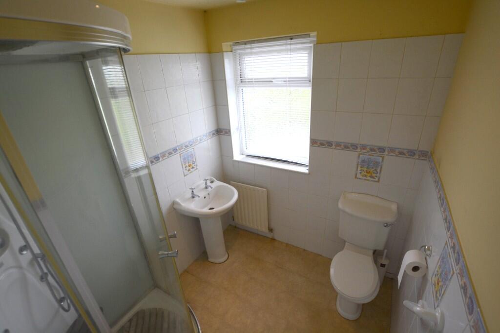
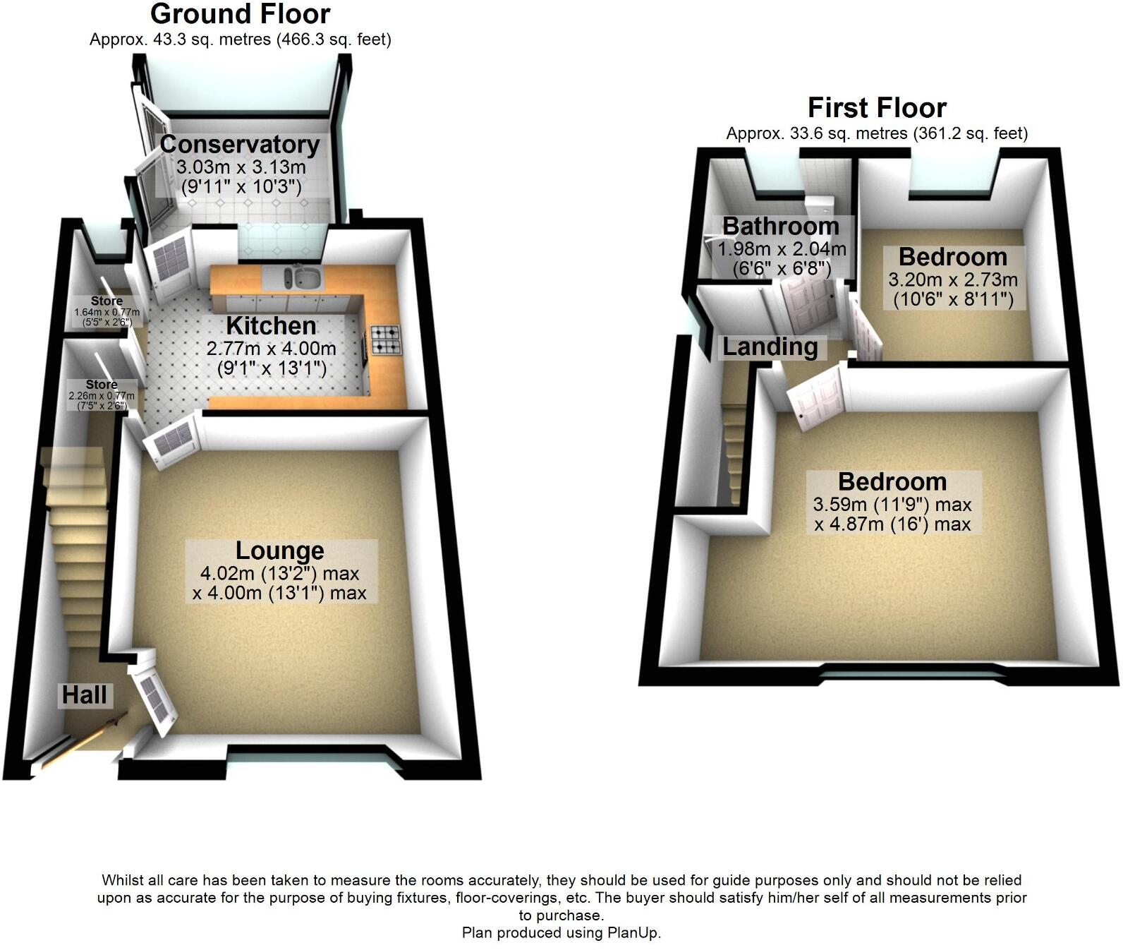
- Bathroom:
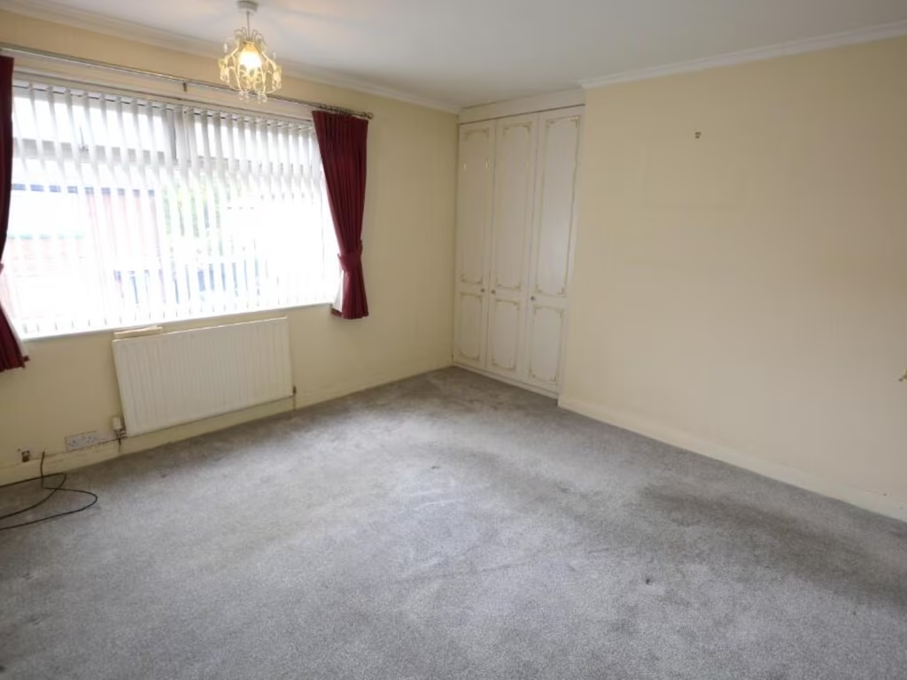
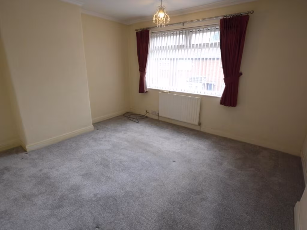
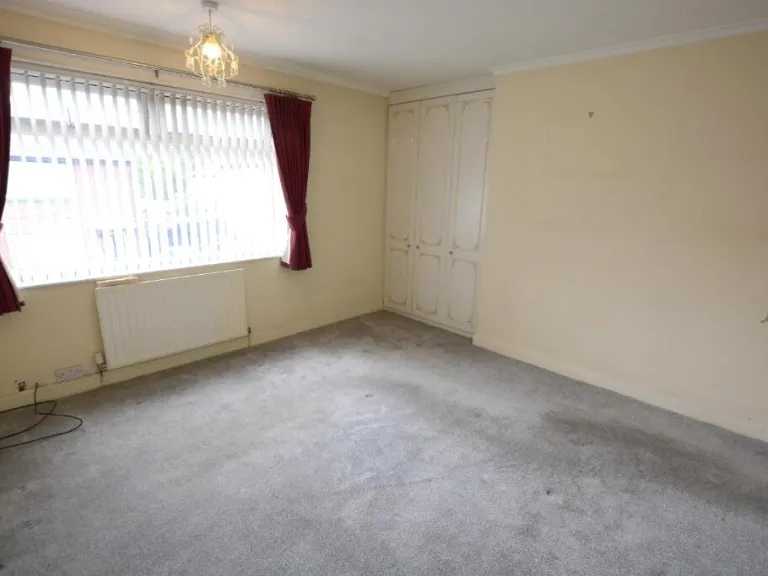
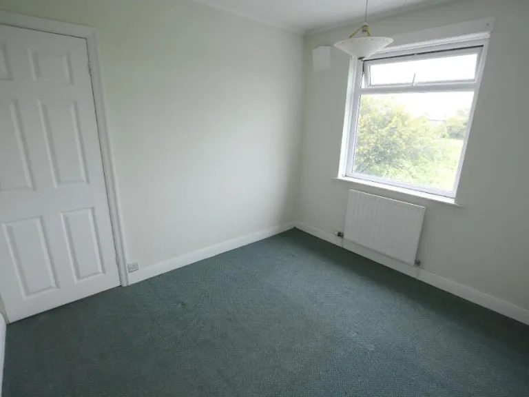
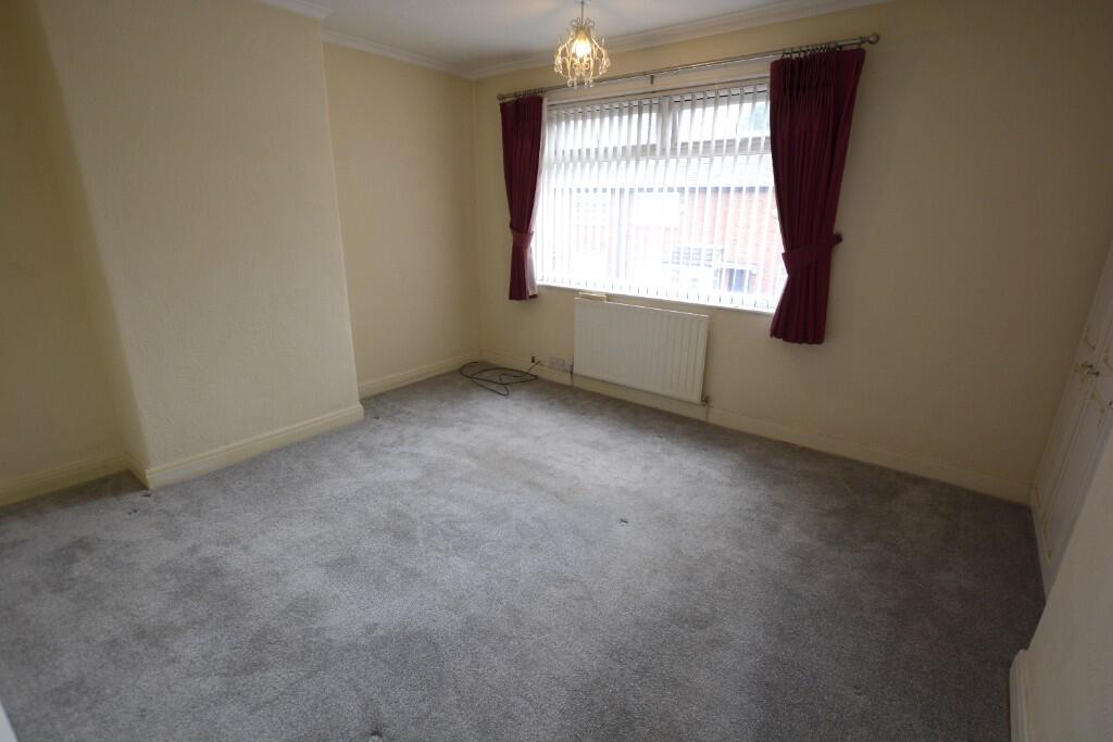
- Bedroom:
- Bedroom:
- Landing:
Textual Property Features
Detected Visual Features
- semi-detached
- post-war
- traditional
- brick exterior
- two-story
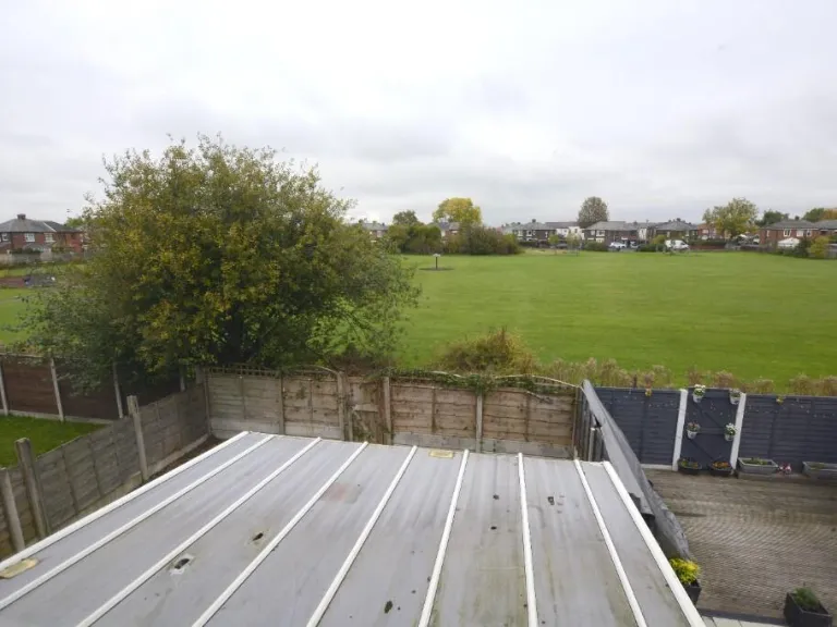
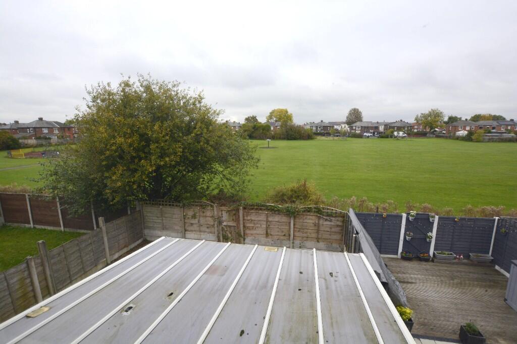
- front garden
- side driveway
- fence
- gate
- residential
- modern kitchen
- tile flooring
- corner unit
- fitted appliances
- black countertops
- cream cabinetry
- checkered backsplash
Nearby Schools
- Greswell Primary School and Nursery
- Russell Scott Primary School
- Hyde High School
- Audenshaw Primary School
- Aldwyn Primary School
- St John Fisher RC Primary School, Denton
- St Thomas More RC College
- Linden Road Academy and Hearing Impaired Base
- St Anne's Primary School
- St Stephen's CofE Primary School
- Lyndhurst Primary School
- Ashton West End Primary Academy
- Ashlea House School
- Manor Green Primary Academy
- Corrie Primary School
- St Mary's RC Primary School
- Denton Community College
- Audenshaw School
- Poplar Street Primary School
- St Peter's CofE Primary School
- Flowery Field Primary School
- Safe Start Education
- Holy Trinity CofE Primary School
Nearest Bars And Restaurants
- Id: 5622331483
- Tags:
- Amenity: cafe
- Name: Di's Diner
- TagsNormalized:
- Lat: 53.4570887
- Lon: -2.1144647
- FullGeoHash: gcw2pgs617sg
- PartitionGeoHash: gcw2
- Images:
- FoodStandards: null
- Distance: 303
,- Id: 5622148284
- Tags:
- Amenity: fast_food
- Name: Denton Kebab House
- TagsNormalized:
- Lat: 53.4569868
- Lon: -2.1140531
- FullGeoHash: gcw2pgs9dbxg
- PartitionGeoHash: gcw2
- Images:
- FoodStandards: null
- Distance: 302.4
,- Id: 5626723997
- Tags:
- Amenity: fast_food
- Cuisine: sandwich
- Name: Suzanne's
- TagsNormalized:
- Lat: 53.461069
- Lon: -2.116156
- FullGeoHash: gcw2pu713cxd
- PartitionGeoHash: gcw2
- Images:
- FoodStandards: null
- Distance: 301
,- Id: 219752294
- Tags:
- Amenity: fast_food
- Brand: McDonald's
- Brand:wikidata: Q38076
- Brand:wikipedia: en:McDonald's
- Building: yes
- Contact:
- Website: https://www.mcdonalds.com/gb/en-gb/location/denton/denton/crown-point-north-shopping-park/8261328.html
- Cuisine: burger
- Drive_through: yes
- Name: McDonald's
- Takeaway: yes
- Wheelchair: yes
- TagsNormalized:
- fast food
- food
- mcdonalds
- burgers
- drive through
- takeaway
- Lat: 53.4587223
- Lon: -2.1158528
- FullGeoHash: gcw2pgg79h1g
- PartitionGeoHash: gcw2
- Images:
- FoodStandards: null
- Distance: 244.2
,- Id: 589005745
- Tags:
- Amenity: fast_food
- Building: yes
- Cuisine: indian
- Name: Food King
- TagsNormalized:
- Lat: 53.459085
- Lon: -2.1150717
- FullGeoHash: gcw2pggver8p
- PartitionGeoHash: gcw2
- Images:
- FoodStandards: null
- Distance: 182.3
}
Nearest General Shops
- Id: 5624764908
- Tags:
- Name: Lohan Ceilings
- Shop: yes
- TagsNormalized:
- Lat: 53.4604796
- Lon: -2.1157366
- FullGeoHash: gcw2pu5mgg8q
- PartitionGeoHash: gcw2
- Images:
- FoodStandards: null
- Distance: 243.8
,- Id: 5624764907
- Tags:
- Name: Hilbri
- Shop: kitchen
- TagsNormalized:
- Lat: 53.4604263
- Lon: -2.1157102
- FullGeoHash: gcw2pu5ms3u0
- PartitionGeoHash: gcw2
- Images:
- FoodStandards: null
- Distance: 239.7
,- Id: 5622782778
- Tags:
- Brand: Sports Direct
- Brand:wikidata: Q7579661
- Brand:wikipedia: en:SportsDirect.com
- Name: Sports Direct
- Shop: sports
- TagsNormalized:
- Lat: 53.4594459
- Lon: -2.1159326
- FullGeoHash: gcw2pggpz5n2
- PartitionGeoHash: gcw2
- Images:
- FoodStandards: null
- Distance: 232.7
}
Nearest Grocery shops
- Id: 5626723996
- Tags:
- TagsNormalized:
- Lat: 53.4610277
- Lon: -2.116139
- FullGeoHash: gcw2pu7143uk
- PartitionGeoHash: gcw2
- Images:
- FoodStandards: null
- Distance: 297.5
,- Id: 5626642571
- Tags:
- TagsNormalized:
- Lat: 53.4615081
- Lon: -2.1140702
- FullGeoHash: gcw2pukefe7j
- PartitionGeoHash: gcw2
- Images:
- FoodStandards: null
- Distance: 246
,- Id: 589005748
- Tags:
- Building: yes
- Name: Patel Supermarket
- Shop: convenience
- TagsNormalized:
- Lat: 53.459242
- Lon: -2.1151188
- FullGeoHash: gcw2pggydjj0
- PartitionGeoHash: gcw2
- Images:
- FoodStandards: null
- Distance: 181.4
}
Nearest Supermarkets
- Id: 286403404
- Tags:
- Brand: Morrisons
- Brand:wikidata: Q922344
- Brand:wikipedia: en:Morrisons
- Building: yes
- Contact:
- Website: https://my.morrisons.com/storefinder/93
- Name: Morrisons
- Operator: Morrisons
- Shop: supermarket
- Wheelchair: yes
- TagsNormalized:
- Lat: 53.4550428
- Lon: -2.1103504
- FullGeoHash: gcw2pgpq1q0w
- PartitionGeoHash: gcw2
- Images:
- FoodStandards: null
- Distance: 517
,- Id: 5622782767
- Tags:
- Brand: ALDI
- Brand:wikidata: Q41171672
- Brand:wikipedia: en:Aldi
- Contact:
- Website: https://stores.aldi.co.uk/denton/crownpoint-shopping-park
- Name: ALDI
- Shop: supermarket
- TagsNormalized:
- Lat: 53.4576437
- Lon: -2.1188621
- FullGeoHash: gcw2pg9j6gjc
- PartitionGeoHash: gcw2
- Images:
- FoodStandards: null
- Distance: 475.1
,- Id: 588736396
- Tags:
- Addr:
- Country: GB
- Postcode: M34 3LJ
- Street: Ashworth Street
- Brand: Lidl
- Brand:wikidata: Q151954
- Brand:wikipedia: en:Lidl
- Building: yes
- Fhrs:
- Name: Lidl
- Shop: supermarket
- TagsNormalized:
- Lat: 53.4565499
- Lon: -2.1161928
- FullGeoHash: gcw2pg7ncphm
- PartitionGeoHash: gcw2
- Images:
- FoodStandards:
- Id: 21311
- FHRSID: 21311
- LocalAuthorityBusinessID: 07/00008/COM
- BusinessName: Lidl
- BusinessType: Retailers - supermarkets/hypermarkets
- BusinessTypeID: 7840
- AddressLine1: Lidl
- AddressLine2: Ashworth Street
- AddressLine3: Denton
- AddressLine4: Tameside
- PostCode: M34 3LJ
- RatingValue: 5
- RatingKey: fhrs_5_en-GB
- RatingDate: 2022-04-20
- LocalAuthorityCode: 430
- LocalAuthorityName: Tameside
- LocalAuthorityWebSite: http://www.tameside.gov.uk
- LocalAuthorityEmailAddress: environmentalhealth@tameside.gov.uk
- Scores:
- Hygiene: 0
- Structural: 0
- ConfidenceInManagement: 5
- NewRatingPending: false
- Geocode:
- Longitude: -2.11532100000000
- Latitude: 53.45731200000000
- Distance: 414.6
}
Nearest Religious buildings
- Id: 295959748
- Tags:
- Amenity: place_of_worship
- Building: church
- Denomination: anglican
- Name: St. Hilda's
- Religion: christian
- Wikidata: Q105100674
- TagsNormalized:
- place of worship
- church
- anglican
- christian
- Lat: 53.4636998
- Lon: -2.1180834
- FullGeoHash: gcw2puc8t5fx
- PartitionGeoHash: gcw2
- Images:
- FoodStandards: null
- Distance: 596.6
,- Id: 5626723995
- Tags:
- Amenity: place_of_worship
- Name: The Open Door Christian Fellowship
- Religion: christian
- TagsNormalized:
- place of worship
- christian
- church
- Lat: 53.4609406
- Lon: -2.1160975
- FullGeoHash: gcw2pu70e3ek
- PartitionGeoHash: gcw2
- Images:
- FoodStandards: null
- Distance: 289.8
,- Id: 588689910
- Tags:
- Amenity: place_of_worship
- Building: yes
- Religion: christian
- TagsNormalized:
- place of worship
- christian
- church
- Lat: 53.4572098
- Lon: -2.1137676
- FullGeoHash: gcw2pgsfcdht
- PartitionGeoHash: gcw2
- Images:
- FoodStandards: null
- Distance: 272.6
}
Nearest Medical buildings
- Id: 5622782789
- Tags:
- Amenity: pharmacy
- Brand: Boots
- Brand:wikidata: Q6123139
- Brand:wikipedia: en:Boots (company)
- Dispensing: yes
- Healthcare: pharmacy
- Name: Boots
- TagsNormalized:
- pharmacy
- boots
- health
- healthcare
- Lat: 53.4590784
- Lon: -2.1179845
- FullGeoHash: gcw2pgctxqs2
- PartitionGeoHash: gcw2
- Images:
- FoodStandards: null
- Distance: 371.7
,- Id: 5622148288
- Tags:
- Amenity: pharmacy
- Dispensing: yes
- Healthcare: pharmacy
- Name: Greencross Pharmacy
- TagsNormalized:
- Lat: 53.4566505
- Lon: -2.1138607
- FullGeoHash: gcw2pgkxx3zj
- PartitionGeoHash: gcw2
- Images:
- FoodStandards: null
- Distance: 333.7
,- Id: 588715976
- Tags:
- Amenity: dentist
- Building: yes
- Healthcare: dentist
- Name: Denton Orthodontic Centre
- TagsNormalized:
- Lat: 53.4570881
- Lon: -2.1146605
- FullGeoHash: gcw2pgs4hg6z
- PartitionGeoHash: gcw2
- Images:
- FoodStandards: null
- Distance: 309
,- Id: 5624764946
- Tags:
- Amenity: pharmacy
- Brand: Cohens Chemist
- Brand:wikidata: Q107998495
- Dispensing: yes
- Healthcare: pharmacy
- Name: Cohens Chemist
- TagsNormalized:
- pharmacy
- chemist
- cohens chemist
- health
- healthcare
- Lat: 53.4596993
- Lon: -2.1154728
- FullGeoHash: gcw2pu593fjp
- PartitionGeoHash: gcw2
- Images:
- FoodStandards: null
- Distance: 203
}
Nearest Airports
- Id: 1224469
- Tags:
- Addr:
- City: Manchester
- Country: GB
- Postcode: M90 1QX
- Aerodrome: international
- Aeroway: aerodrome
- Arp: yes
- Atis: 128.175
- Iata: MAN
- Icao: EGCC
- Name: Manchester Airport
- Note: rough sketched outline referring to Yahoo imagery - true boundary is where?
- Old_name: Ringway
- Operator: Manchester Airport PLC
- Size: 18720000
- Source:
- Tower_frequency: 118.625,119.400
- Type: multipolygon
- Website: https://www.manchesterairport.co.uk/
- Wikidata: Q8694
- Wikipedia: en:Manchester Airport
- TagsNormalized:
- airport
- international airport
- Lat: 53.3503197
- Lon: -2.2798822
- FullGeoHash: gcqrs05u4ukt
- PartitionGeoHash: gcqr
- Images:
- FoodStandards: null
- Distance: 16452.6
}
Nearest Leisure Facilities
- Id: 588229266
- Tags:
- Leisure: pitch
- Sport: soccer
- TagsNormalized:
- Lat: 53.4634401
- Lon: -2.1124228
- FullGeoHash: gcw2putz0gx6
- PartitionGeoHash: gcw2
- Images:
- FoodStandards: null
- Distance: 435.2
,- Id: 5656703849
- Tags:
- Leisure: sports_centre
- Name: Progressive Sports
- TagsNormalized:
- sports
- sports centre
- leisure
- Lat: 53.4561772
- Lon: -2.1100523
- FullGeoHash: gcw2pgrsb1wv
- PartitionGeoHash: gcw2
- Images:
- FoodStandards: null
- Distance: 404.1
,- Id: 853029394
- Tags:
- Building: yes
- Leisure: fitness_centre
- Name: Tameside Wellness Centre
- TagsNormalized:
- fitness
- fitness centre
- leisure
- Lat: 53.457552
- Lon: -2.1135202
- FullGeoHash: gcw2pgsuz3vn
- PartitionGeoHash: gcw2
- Images:
- FoodStandards: null
- Distance: 231.3
,- Id: 588229263
- Tags:
- Leisure: pitch
- Sport: soccer
- TagsNormalized:
- Lat: 53.4601057
- Lon: -2.111302
- FullGeoHash: gcw2puneen50
- PartitionGeoHash: gcw2
- Images:
- FoodStandards: null
- Distance: 98.1
,- Id: 588229260
- Tags:
- TagsNormalized:
- Lat: 53.459896
- Lon: -2.1131717
- FullGeoHash: gcw2puj4rwbv
- PartitionGeoHash: gcw2
- Images:
- FoodStandards: null
- Distance: 64.5
}
Nearest Tourist attractions
- Id: 3415808025
- Tags:
- Addr:
- City: Manchester
- Housename: Donkey Assisted Therapy Centre
- Postcode: M18 8RJ
- Street: Greenfold, Abbey Hey
- Name: The Donkey Sanctuary
- Tourism: attraction
- TagsNormalized:
- Lat: 53.4647068
- Lon: -2.1562782
- FullGeoHash: gcw2nuvy7pdq
- PartitionGeoHash: gcw2
- Images:
- FoodStandards: null
- Distance: 2960
,- Id: 919564316
- Tags:
- Addr:
- City: Ashton-under-Lyne
- Postcode: OL7 0QA
- Street: Portland Place
- Museum: local_history
- Name: Portland Basin Museum
- Opening_hours: Tu-Su 10:00-16:00
- Phone: +44 161 342 5480
- Source: OS_OpenData_StreetView
- Tourism: museum
- Website: https://www.tameside.gov.uk/museumsgalleries/portland
- Wikidata: Q113370036
- TagsNormalized:
- Lat: 53.4830436
- Lon: -2.0998516
- FullGeoHash: gcw820qcmcvn
- PartitionGeoHash: gcw8
- Images:
- FoodStandards: null
- Distance: 2744.1
,- Id: 385221589
- Tags:
- Name: Dukinfield Swimming Pool
- Tourism: attraction
- TagsNormalized:
- swimming
- swimming pool
- pool
- attraction
- tourism
- Lat: 53.4735555
- Lon: -2.0788551
- FullGeoHash: gcw80ww4p1jr
- PartitionGeoHash: gcw8
- Images:
- FoodStandards: null
- Distance: 2714.7
}
Nearest Hotels
- Id: 933596226
- Tags:
- Internet_access: wlan
- Internet_access:fee: no
- Name: Village Hotel
- Operator: De Vere
- Smoking: no
- Tourism: hotel
- Wheelchair: yes
- TagsNormalized:
- Lat: 53.465283
- Lon: -2.0897726
- FullGeoHash: gcw80mn3bg0s
- PartitionGeoHash: gcw8
- Images:
- FoodStandards: null
- Distance: 1630.2
,- Id: 592060448
- Tags:
- Brand: Premier Inn
- Brand:wikidata: Q2108626
- Brand:wikipedia: en:Premier Inn
- Building: yes
- Internet_access: wlan
- Internet_access:fee: customers
- Internet_access:operator: Virgin Media
- Internet_access:ssid: Premier Inn Free Wi-Fi
- Name: Premier Inn
- Tourism: hotel
- TagsNormalized:
- Lat: 53.4556392
- Lon: -2.1342831
- FullGeoHash: gcw2p7mcet7h
- PartitionGeoHash: gcw2
- Images:
- FoodStandards: null
- Distance: 1510.6
,- Id: 1289959765
- Tags:
- Amenity: pub
- Name: The Cock Hotel
- TagsNormalized:
- Lat: 53.4469505
- Lon: -2.1064743
- FullGeoHash: gcw801dp59dy
- PartitionGeoHash: gcw8
- Images:
- FoodStandards: null
- Distance: 1452.7
}
Tags
- semi-detached
- post-war
- traditional
- brick exterior
- two-story
- front garden
- side driveway
- fence
- gate
- residential
- modern kitchen
- tile flooring
- corner unit
- fitted appliances
- black countertops
- cream cabinetry
- checkered backsplash
Local Market Stats
- Average Price/sqft: £233
- Avg Income: £38200
- Rental Yield: 5%
- Social Housing: 14%
- Planning Success Rate: 90%
AirBnB Data
- 1km average: £75/night
- Listings in 1km: 1
Similar Properties
 2 bedroom terraced house for sale in Larch Road, Denton, M34 — £200,000 • 2 bed • 1 bath • 848 ft²
 2 bedroom terraced house for sale in Booth Street, Denton, Manchester, Greater Manchester, M34 — £170,000 • 2 bed • 1 bath • 1096 ft²
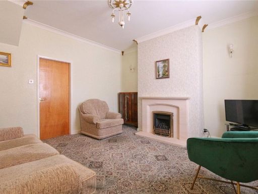 2 bedroom terraced house for sale in Osborne Road, Denton, Manchester, Greater Manchester, M34 — £160,000 • 2 bed • 1 bath • 722 ft²
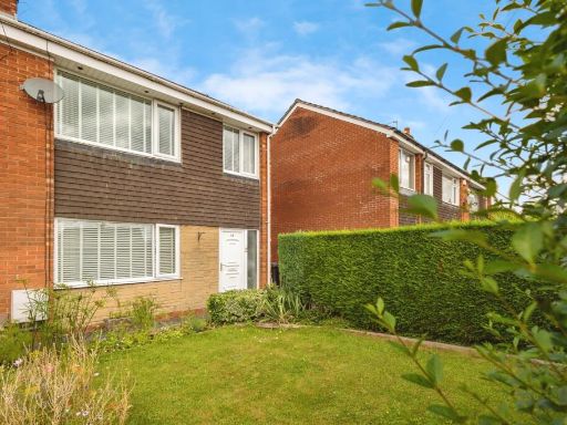 3 bedroom semi-detached house for sale in Weston Drive, Denton, Manchester, Greater Manchester, M34 — £250,000 • 3 bed • 1 bath • 786 ft²
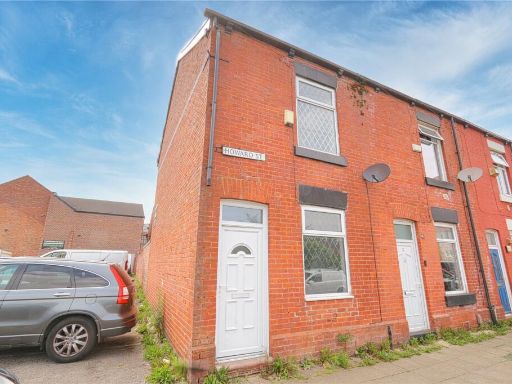 2 bedroom terraced house for sale in Howard Street, Denton, Manchester, M34 — £140,000 • 2 bed • 1 bath • 755 ft²
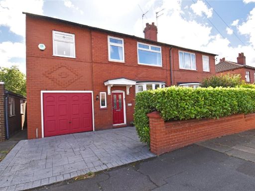 4 bedroom semi-detached house for sale in Stockport Road, Denton, Tameside, M34 — £350,000 • 4 bed • 1 bath • 1250 ft²
Meta
- {
"@context": "https://schema.org",
"@type": "Residence",
"name": "2 bedroom semidetached house for sale in York Road, Denton,…",
"description": "",
"url": "https://propertypiper.co.uk/property/a4eaa1da-6f4f-4030-b915-49bf64b9ab50",
"image": "https://image-a.propertypiper.co.uk/ec64b5b1-78f6-4f0d-aefe-84cf9822be14-1024.jpeg",
"address": {
"@type": "PostalAddress",
"streetAddress": "\n 65 York Road,Denton,MANCHESTER,M34 3HH\n ",
"postalCode": "M34 3HH",
"addressLocality": "Tameside",
"addressRegion": "Denton and Reddish",
"addressCountry": "England"
},
"geo": {
"@type": "GeoCoordinates",
"latitude": 53.4595263545482,
"longitude": -2.112420085630278
},
"numberOfRooms": 2,
"numberOfBathroomsTotal": 1,
"floorSize": {
"@type": "QuantitativeValue",
"value": 827,
"unitCode": "FTK"
},
"offers": {
"@type": "Offer",
"price": 180000,
"priceCurrency": "GBP",
"availability": "https://schema.org/InStock"
},
"additionalProperty": [
{
"@type": "PropertyValue",
"name": "Feature",
"value": "semi-detached"
},
{
"@type": "PropertyValue",
"name": "Feature",
"value": "post-war"
},
{
"@type": "PropertyValue",
"name": "Feature",
"value": "traditional"
},
{
"@type": "PropertyValue",
"name": "Feature",
"value": "brick exterior"
},
{
"@type": "PropertyValue",
"name": "Feature",
"value": "two-story"
},
{
"@type": "PropertyValue",
"name": "Feature",
"value": "front garden"
},
{
"@type": "PropertyValue",
"name": "Feature",
"value": "side driveway"
},
{
"@type": "PropertyValue",
"name": "Feature",
"value": "fence"
},
{
"@type": "PropertyValue",
"name": "Feature",
"value": "gate"
},
{
"@type": "PropertyValue",
"name": "Feature",
"value": "residential"
},
{
"@type": "PropertyValue",
"name": "Feature",
"value": "modern kitchen"
},
{
"@type": "PropertyValue",
"name": "Feature",
"value": "tile flooring"
},
{
"@type": "PropertyValue",
"name": "Feature",
"value": "corner unit"
},
{
"@type": "PropertyValue",
"name": "Feature",
"value": "fitted appliances"
},
{
"@type": "PropertyValue",
"name": "Feature",
"value": "black countertops"
},
{
"@type": "PropertyValue",
"name": "Feature",
"value": "cream cabinetry"
},
{
"@type": "PropertyValue",
"name": "Feature",
"value": "checkered backsplash"
}
]
}
High Res Floorplan Images
Compatible Floorplan Images
FloorplanImages Thumbnail