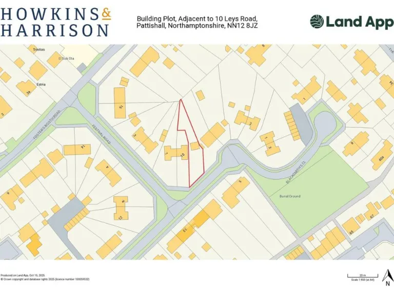
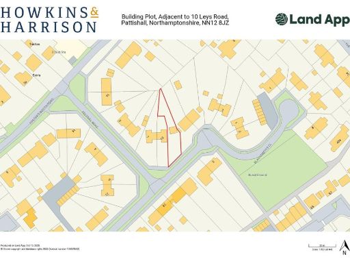
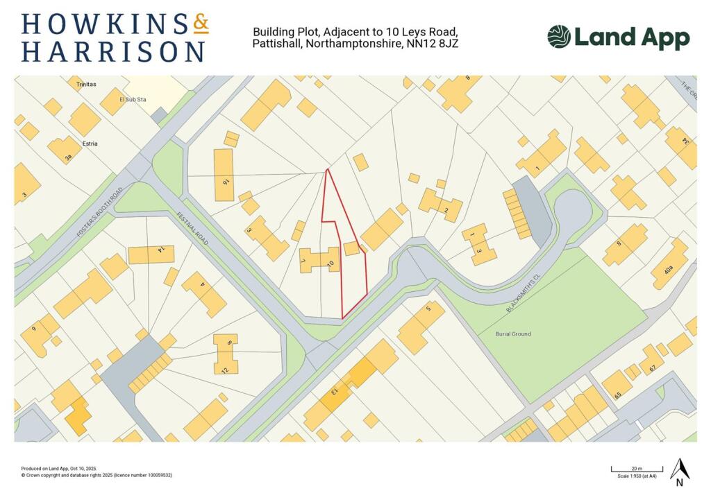
NN12 8JZ - Plot for sale in Leys Road, Pattishall, NN12
View on Property Piper
Plot for sale in Leys Road, Pattishall, NN12
Property Details
- Price: £85000
- Bedrooms: 1
- Bathrooms: 1
- Property Type: undefined
- Property SubType: undefined
Brochure Descriptions
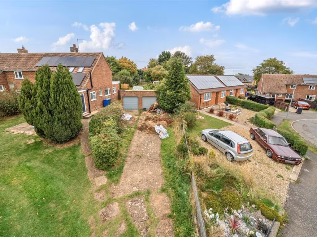
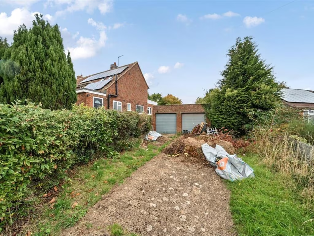
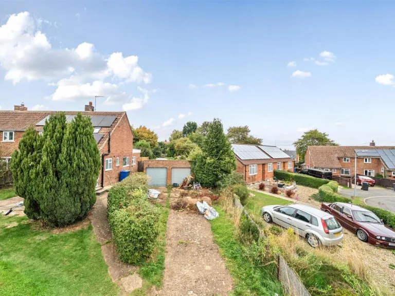
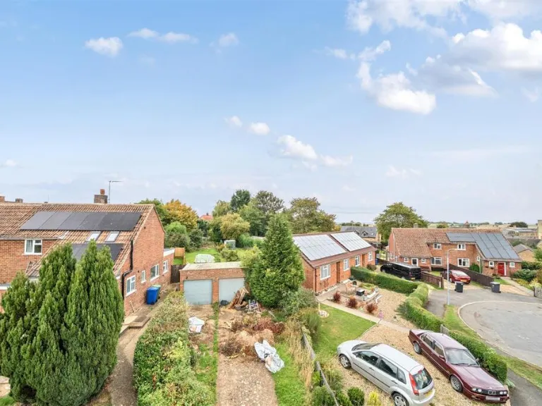
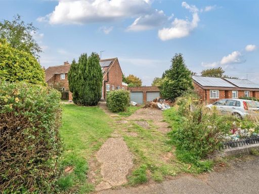
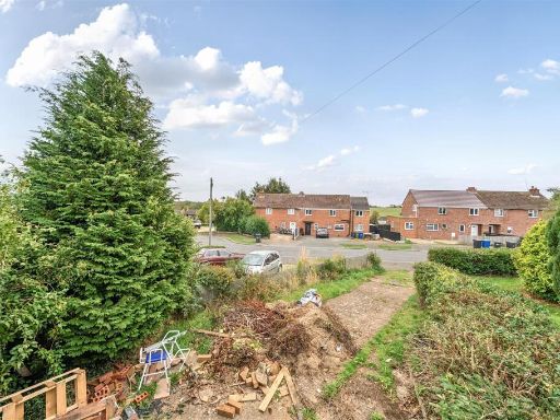
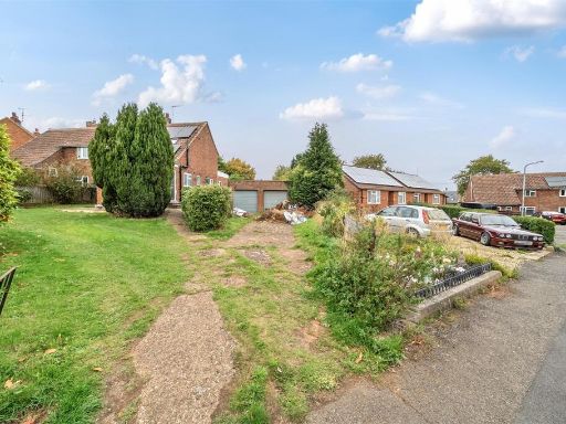
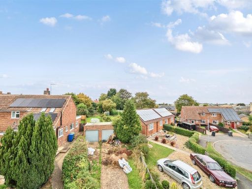
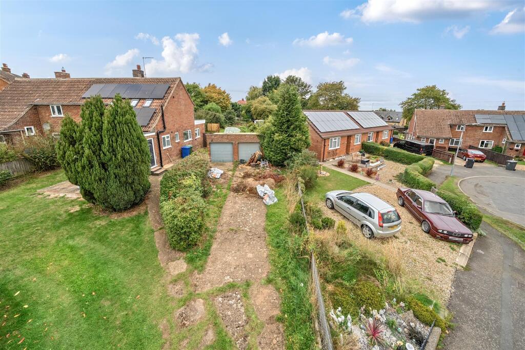
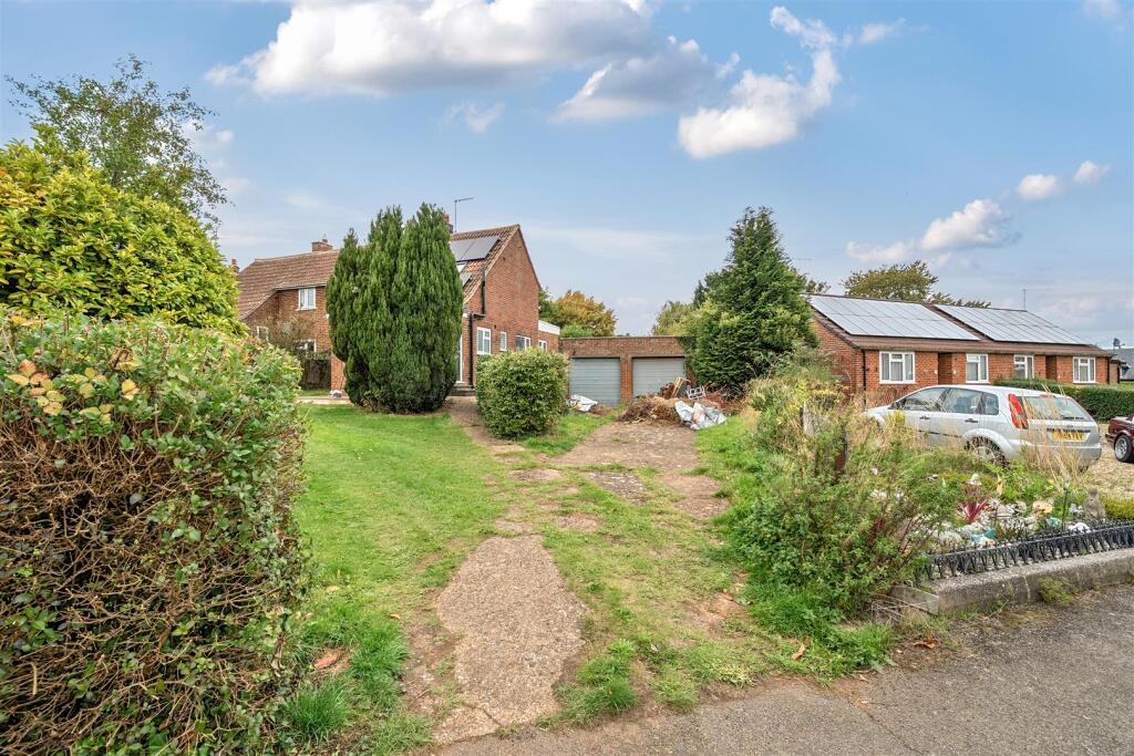
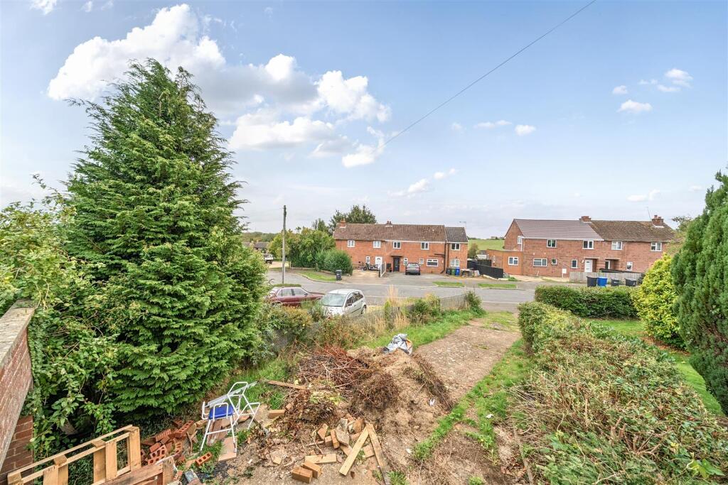
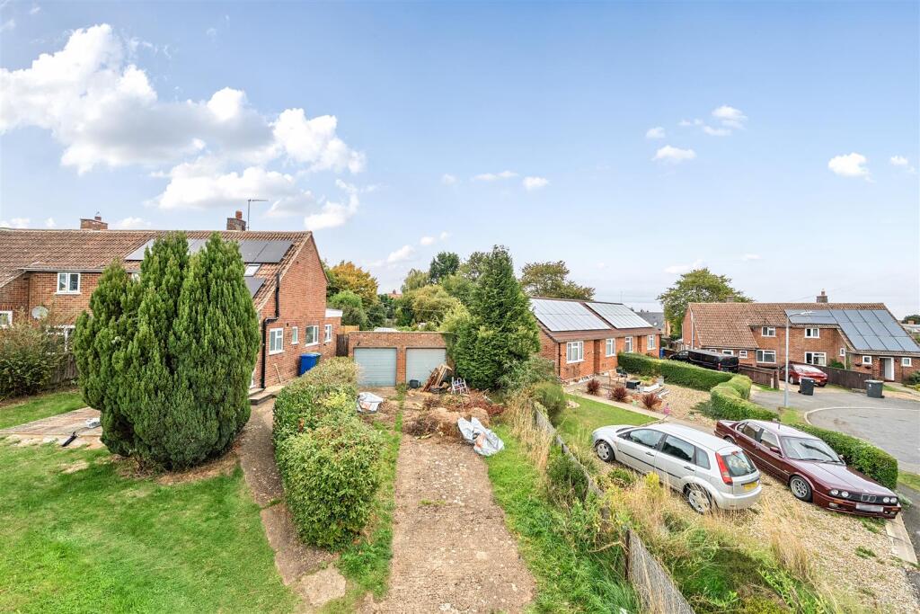
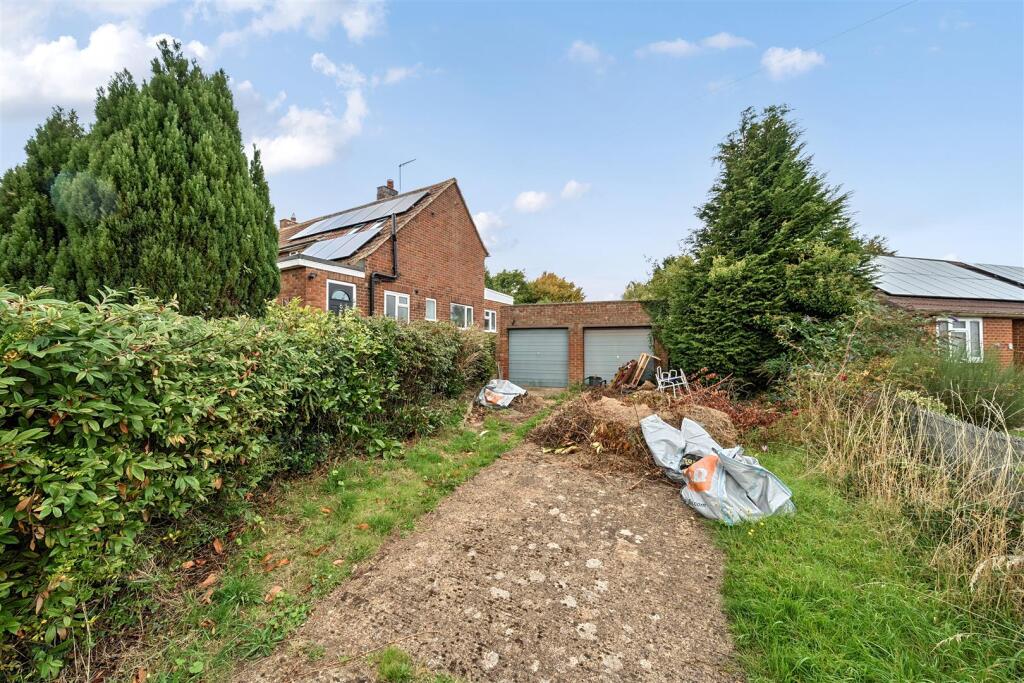
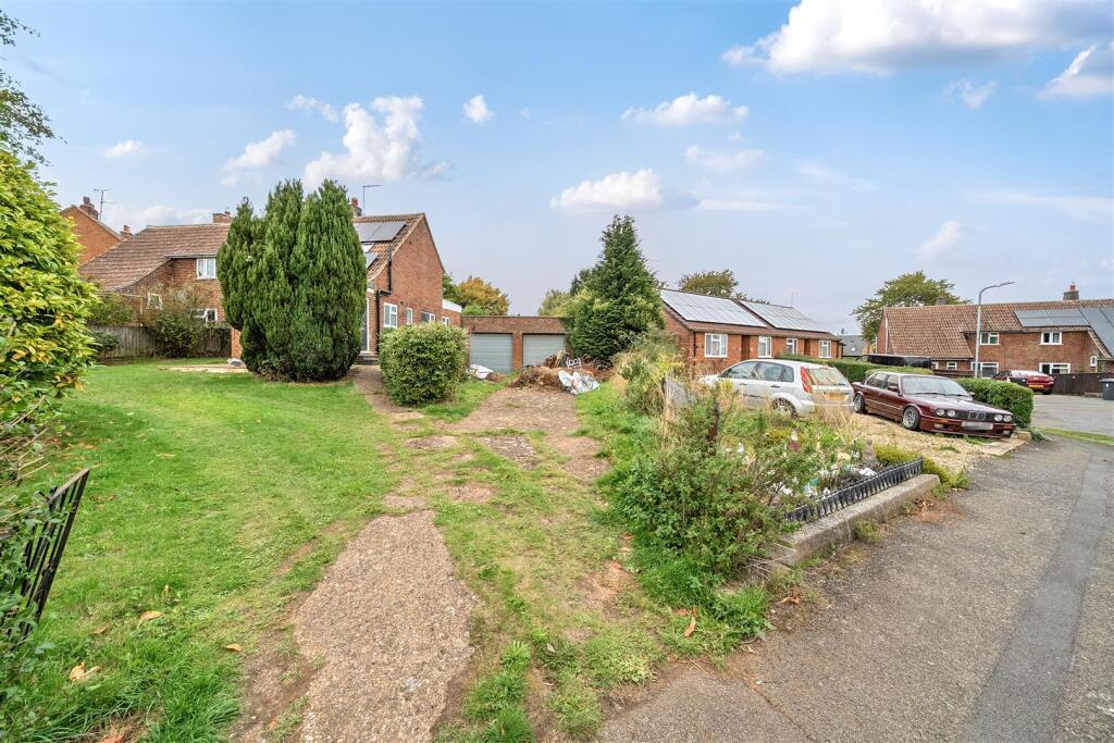
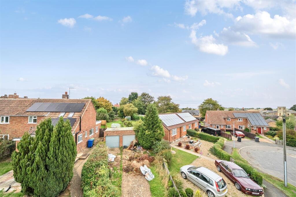
- A building plot located adjacent to number 10 Leys Road in the village of Pattishall. The site appears to include a detached double garage set to the rear of a residential plot with an overgrown garden area and vehicular access from the road. The immediate context is suburban: single-storey/one-and-a-half storey homes, front gardens and a residential street. The plot is small-to-average in garden size for a suburban infill site and would be suitable for a single dwelling (subject to planning). There are no notable long-distance views — outlook is onto neighbouring gardens and houses. Condition: untidy/overgrown and would require clearance and likely drainage/utility checks prior to development.
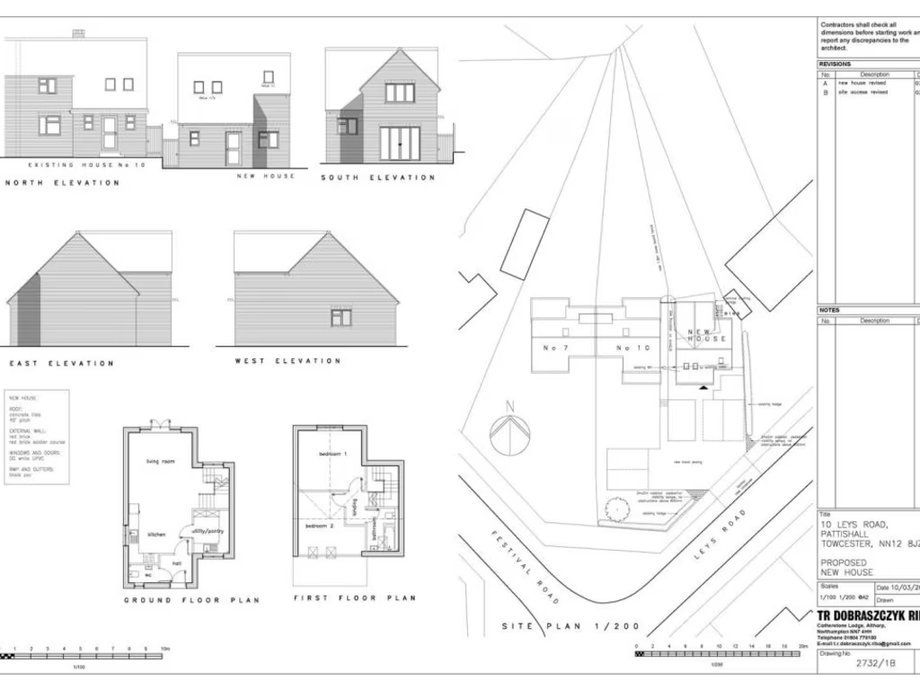
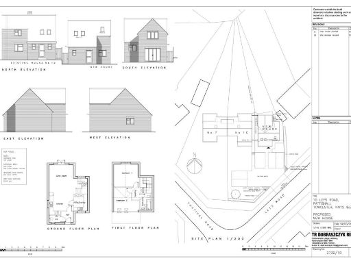
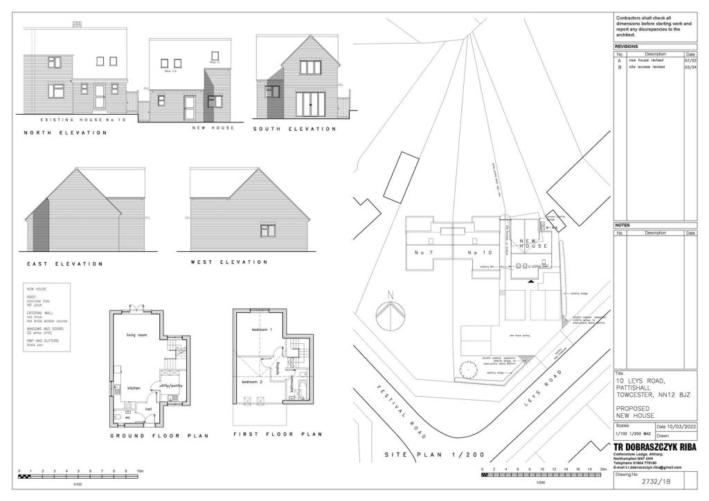
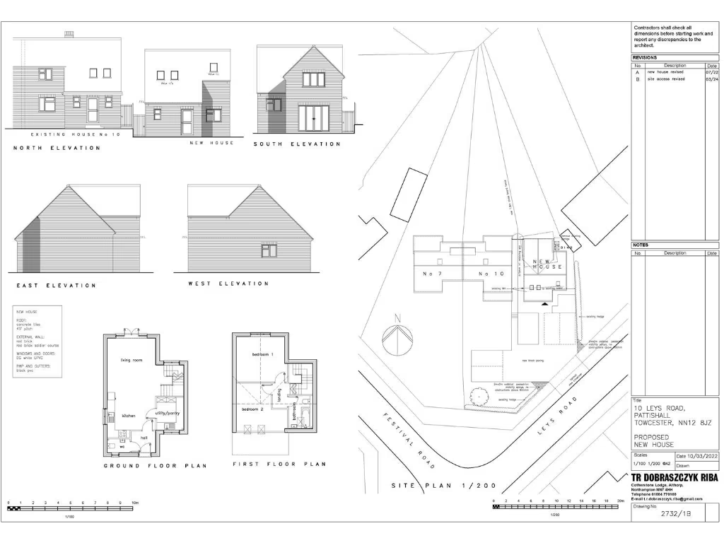
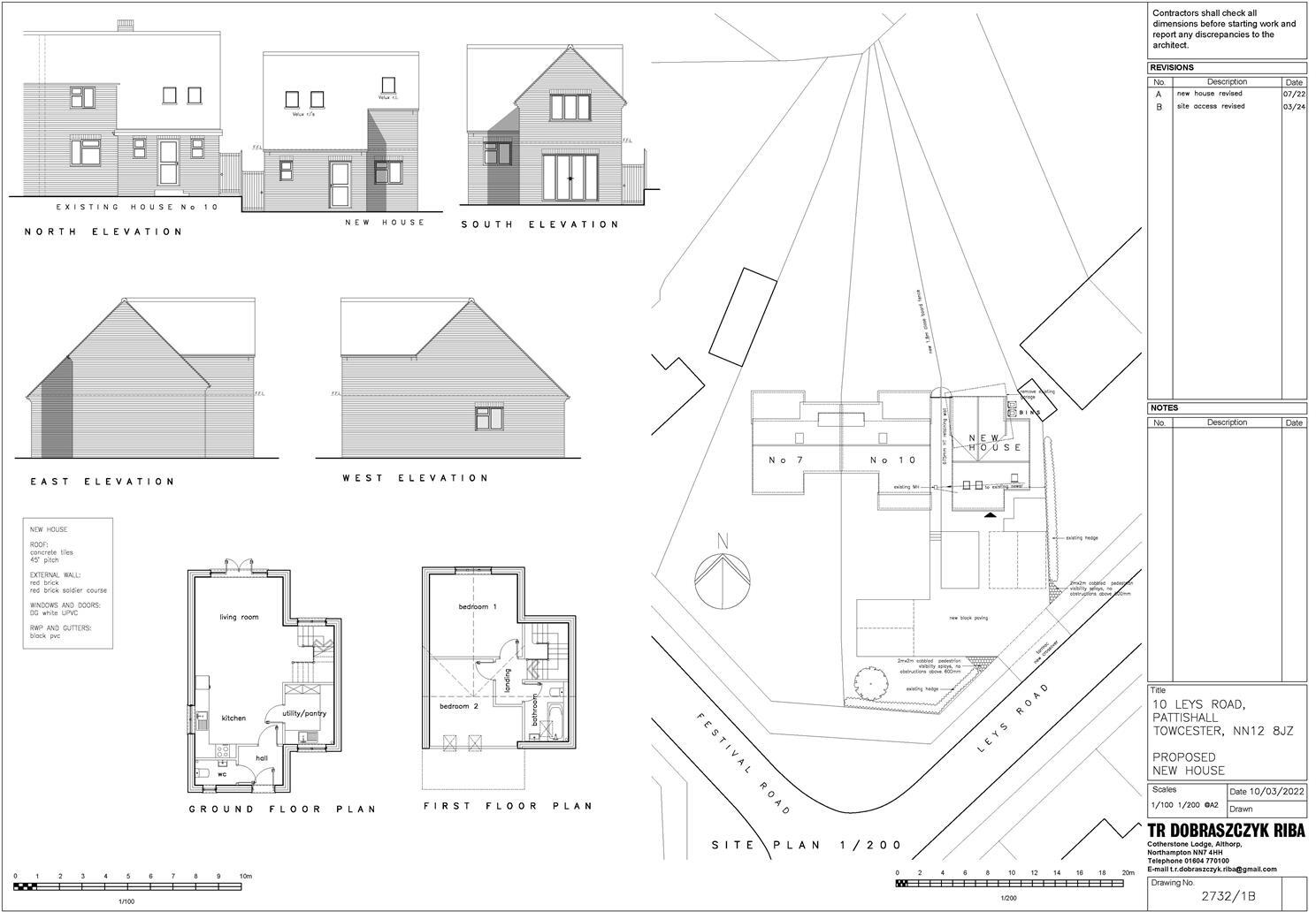
- A single building plot with Full Planning Permission (ref 2024/1214/FULL) for a two-storey, two-bedroom detached house with garden and driveway parking. Situated in the village of Pattishall, Northamptonshire, the plot is described as a small to average residential building plot immediately adjacent to number 10 Leys Road. The planning consent includes typical elevations and a site layout showing private garden and on-plot parking. Suitable for self-build or developer purchase subject to Community Infrastructure Levy considerations and local authority checks; plot appears to offer standard village views (residential) and limited external amenity space appropriate for a two-bedroom dwelling.
Image Descriptions
- exterior and garden Mid-20th Century
- exterior Mid-20th Century Suburban
Floorplan Description
- Proposed new house (plans for new house at 10 Leys Road)
Rooms
- living room:
- kitchen:
- utility/pantry:
- hall:
- bedroom 1:
- bedroom 2:
- bathroom:
Textual Property Features
Detected Visual Features
- mid-20th century
- detached
- two-story
- solar panels
- garage
- driveway
- unenclosed garden
- needs landscaping
- patchy lawn
- external wear
- detached house
- brick exterior
- garden
- suburban
Nearby Schools
- Marie Weller Primary School
- Tiffield Church of England Voluntary Aided Primary School
- Gayton Church of England Primary School
- Hunsbury Park Primary School
- St Luke's Church of England Primary School
- Harpole Primary School
- The Duston School
- Nicholas Hawksmoor Primary School
- Towcester Church of England Primary School
- Sponne School
- Oneschool Global Uk, Northampton Campus
- Kislingbury Primary School
- Hopping Hill Primary School
- Blisworth Community Primary School
- Upton Meadows Primary School
- Greens Norton Church of England Primary School
- Bugbrooke Community Primary School
- The Bliss Charity School
- Weedon Bec Primary School
- Flore Church of England Primary School
- Milton Parochial Primary School
- Rothersthorpe Church of England Primary School
- Campion School
- Pineham Barns Primary School
- Briar Hill Primary School & Nursery
- Quinton House School
- Millway Primary School
- Blakesley Church of England Primary School
- Pattishall Church of England Primary School
Nearest General Shops
- Id: 559507262
- Tags:
- Addr:
- City: Northampton
- Country: GB
- Housenumber: 32a
- Postcode: NN7 3PA
- Street: High Street
- Village: Bugbrooke
- Building: yes
- Fhrs:
- Authority: West Northamptonshire
- Id: 1592171
- Local_authority_id: FR/202300022
- Name: Philippa's
- Shop: deli
- Website: https://www.thepantrydoor.org/
- TagsNormalized:
- Lat: 52.2099943
- Lon: -1.010717
- FullGeoHash: gcr31081286g
- PartitionGeoHash: gcr3
- Images:
- FoodStandards:
- Id: 1592171
- FHRSID: 1592171
- LocalAuthorityBusinessID: FR/202300022
- BusinessName: Philippa's Ltd
- BusinessType: Retailers - other
- BusinessTypeID: 4613
- AddressLine1: 32A High Street
- AddressLine2: Bugbrooke
- AddressLine3: null
- AddressLine4: null
- PostCode: NN7 3PA
- RatingValue: AwaitingInspection
- RatingKey: fhrs_awaitinginspection_en-GB
- RatingDate: null
- LocalAuthorityCode: 236
- LocalAuthorityName: West Northamptonshire
- LocalAuthorityWebSite: https://www.westnorthants.gov.uk
- LocalAuthorityEmailAddress: contactus@westnorthants.gov.uk
- Scores:
- Hygiene: null
- Structural: null
- ConfidenceInManagement: null
- NewRatingPending: false
- Geocode:
- Longitude: null
- Latitude: null
- Distance: 3269.2
,- Id: 558915582
- Tags:
- Building: yes
- Name: Pet Stop
- Shop: pet
- TagsNormalized:
- Lat: 52.2076419
- Lon: -1.0091422
- FullGeoHash: gcr31015t3c4
- PartitionGeoHash: gcr3
- Images:
- FoodStandards: null
- Distance: 3049.8
,- Id: 391247346
- Tags:
- Building: yes
- Name: John's Motors
- Shop: car_repair
- TagsNormalized:
- Lat: 52.1790575
- Lon: -1.0248038
- FullGeoHash: gcr2bdvv036f
- PartitionGeoHash: gcr2
- Images:
- FoodStandards: null
- Distance: 303.3
}
Nearest Grocery shops
- Id: 2105778179
- Tags:
- Addr:
- City: Northampton
- Country: GB
- Housename: New Creation Farm Shop
- Place: Nether Heyford
- Postcode: NN7 3LB
- Street: Furnace Lane
- Name: New Creation Farm Shop
- Opening_hours: Mo-Fr 09:00-17:00
- Shop: greengrocer
- TagsNormalized:
- farm
- farm shop
- shop
- greengrocer
- grocer
- Lat: 52.211225
- Lon: -1.0418241
- FullGeoHash: gcr302c27tz8
- PartitionGeoHash: gcr3
- Images:
- FoodStandards: null
- Distance: 3526.4
,- Id: 6661609986
- Tags:
- Addr:
- Postcode: NN7 3LB
- Street: Furnace Lane
- Name: Nene Valley Firewood
- Opening_hours: Mo-Fr 09:00-17:00
- Phone: +44 1327344515
- Shop: greengrocer
- Website: https://www.facebook.com/nenevalleyfirewood/
- TagsNormalized:
- Lat: 52.2112035
- Lon: -1.0416304
- FullGeoHash: gcr302c823b0
- PartitionGeoHash: gcr3
- Images:
- FoodStandards: null
- Distance: 3519.5
,- Id: 4346698
- Tags:
- Addr:
- City: Northampton
- Country: GB
- Housenumber: 40
- Postcode: NN7 3PG
- Street: High Street
- Village: Bugbrooke
- Brand: Londis
- Brand:wikidata: Q21008564
- Fhrs:
- Authority: West Northamptonshire
- Id: 1541632
- Local_authority_id: FR/202200023
- Landuse: retail
- Name: Londis
- Shop: convenience
- TagsNormalized:
- londis
- retail
- convenience
- shop
- Lat: 52.2089551
- Lon: -1.0104891
- FullGeoHash: gcr31025jyss
- PartitionGeoHash: gcr3
- Images:
- FoodStandards:
- Id: 1541632
- FHRSID: 1541632
- LocalAuthorityBusinessID: FR/202200023
- BusinessName: Londis
- BusinessType: Retailers - other
- BusinessTypeID: 4613
- AddressLine1: 40 High Street
- AddressLine2: Bugbrooke
- AddressLine3: null
- AddressLine4: null
- PostCode: NN7 3PG
- RatingValue: 4
- RatingKey: fhrs_4_en-GB
- RatingDate: 2022-05-25
- LocalAuthorityCode: 236
- LocalAuthorityName: West Northamptonshire
- LocalAuthorityWebSite: https://www.westnorthants.gov.uk
- LocalAuthorityEmailAddress: contactus@westnorthants.gov.uk
- Scores:
- Hygiene: 5
- Structural: 5
- ConfidenceInManagement: 10
- NewRatingPending: false
- Geocode:
- Longitude: -1.01045710000000
- Latitude: 52.20892180000000
- Distance: 3162.1
}
Nearest Airports
- Id: 110273499
- Tags:
- Addr:
- Country: GB
- Postcode: LU2 9LY
- Aerodrome: international
- Aerodrome:type: public
- Aeroway: aerodrome
- Alt_name: London Luton
- Iata: LTN
- Icao: EGGW
- Name: London Luton Airport
- Website: https://www.london-luton.co.uk/
- Wikidata: Q8712
- Wikipedia: en:Luton Airport
- TagsNormalized:
- airport
- international airport
- Lat: 51.8780363
- Lon: -0.3701408
- FullGeoHash: gcpxps47rngh
- PartitionGeoHash: gcpx
- Images:
- FoodStandards: null
- Distance: 56000.4
}
Nearest Leisure Facilities
- Id: 260983209
- Tags:
- Leisure: pitch
- Sport: tennis
- TagsNormalized:
- Lat: 52.1767936
- Lon: -1.0118593
- FullGeoHash: gcr2bfrpvgr1
- PartitionGeoHash: gcr2
- Images:
- FoodStandards: null
- Distance: 945.5
,- Id: 260983211
- Tags:
- TagsNormalized:
- Lat: 52.1769384
- Lon: -1.0121386
- FullGeoHash: gcr2bfwbxqqc
- PartitionGeoHash: gcr2
- Images:
- FoodStandards: null
- Distance: 920.6
,- Id: 1100633815
- Tags:
- Leisure: pitch
- Sport: cricket
- TagsNormalized:
- pitch
- leisure
- cricket
- sports
- Lat: 52.176555
- Lon: -1.013535
- FullGeoHash: gcr2bfmyqyvd
- PartitionGeoHash: gcr2
- Images:
- FoodStandards: null
- Distance: 870.8
,- Id: 1100633814
- Tags:
- Leisure: pitch
- Sport: soccer
- TagsNormalized:
- Lat: 52.1765082
- Lon: -1.0142277
- FullGeoHash: gcr2bfmqny14
- PartitionGeoHash: gcr2
- Images:
- FoodStandards: null
- Distance: 838.8
,- Id: 241866483
- Tags:
- TagsNormalized:
- Lat: 52.1808731
- Lon: -1.0208802
- FullGeoHash: gcr2bg0xegb8
- PartitionGeoHash: gcr2
- Images:
- FoodStandards: null
- Distance: 183.2
}
Nearest Tourist attractions
- Id: 654388364
- Tags:
- Addr:
- City: Towcester
- Postcode: NN12 8ET
- Street: Watling Street
- Building: yes
- Guest_house: guest_house
- Name: Bairstows Lodge
- Rooms: 3
- Tourism: guest_house
- Website: http://www.bairstowslodge.co.uk/
- TagsNormalized:
- Lat: 52.145259
- Lon: -1.000932
- FullGeoHash: gcr29hz0hsg4
- PartitionGeoHash: gcr2
- Images:
- FoodStandards: null
- Distance: 4320.8
,- Id: 333650426
- Tags:
- Amenity: notice_board
- Board: notice_board
- Information: board
- Tourism: information
- TagsNormalized:
- Lat: 52.1507444
- Lon: -1.0170055
- FullGeoHash: gcr28vg2n53e
- PartitionGeoHash: gcr2
- Images:
- FoodStandards: null
- Distance: 3459.6
,- Id: 4827648670
- Tags:
- Addr:
- City: Towcester
- Country: GB
- Housename: The Old Stables
- Place: Eastcote
- Postcode: NN12 8NG
- Street: Gayton Road
- Fhrs:
- Authority: West Northamptonshire
- Id: 1541096
- Local_authority_id: FR/000002041
- Name: The Coach House B&B
- Tourism: guest_house
- TagsNormalized:
- Lat: 52.1790076
- Lon: -1.0068047
- FullGeoHash: gcr2c4fugb00
- PartitionGeoHash: gcr2
- Images:
- FoodStandards:
- Id: 1541096
- FHRSID: 1541096
- LocalAuthorityBusinessID: FR/000002041
- BusinessName: The Coach House B&B
- BusinessType: Hotel/bed & breakfast/guest house
- BusinessTypeID: 7842
- AddressLine1: The Old Stables
- AddressLine2: Gayton Road
- AddressLine3: Eastcote
- AddressLine4: null
- PostCode: NN12 8NG
- RatingValue: 5
- RatingKey: fhrs_5_en-GB
- RatingDate: 2021-03-01
- LocalAuthorityCode: 236
- LocalAuthorityName: West Northamptonshire
- LocalAuthorityWebSite: https://www.westnorthants.gov.uk
- LocalAuthorityEmailAddress: contactus@westnorthants.gov.uk
- Scores:
- Hygiene: 0
- Structural: 0
- ConfidenceInManagement: 0
- NewRatingPending: false
- Geocode:
- Longitude: -1.00708310000000
- Latitude: 52.17899960000000
- Distance: 1160
}
Nearest Bus stations and stops
- Id: 26476736
- Tags:
- Bus: yes
- Highway: bus_stop
- Note: check tag
- Public_transport: platform
- TagsNormalized:
- Lat: 52.2076681
- Lon: -1.0142854
- FullGeoHash: gcr30bj7tqty
- PartitionGeoHash: gcr3
- Images:
- FoodStandards: null
- Distance: 2960.6
,- Id: 26477314
- Tags:
- Bus: yes
- Highway: bus_stop
- Public_transport: platform
- TagsNormalized:
- Lat: 52.2078475
- Lon: -1.0168495
- FullGeoHash: gcr30b5sc8nj
- PartitionGeoHash: gcr3
- Images:
- FoodStandards: null
- Distance: 2949.2
,- Id: 26477295
- Tags:
- Bus: yes
- Highway: bus_stop
- Public_transport: platform
- TagsNormalized:
- Lat: 52.2075414
- Lon: -1.0144339
- FullGeoHash: gcr30bj6czp7
- PartitionGeoHash: gcr3
- Images:
- FoodStandards: null
- Distance: 2944.8
,- Id: 26477313
- Tags:
- Bus: yes
- Highway: bus_stop
- Public_transport: platform
- TagsNormalized:
- Lat: 52.2077063
- Lon: -1.0169187
- FullGeoHash: gcr30b5ebjf6
- PartitionGeoHash: gcr3
- Images:
- FoodStandards: null
- Distance: 2933
,- Id: 829529331
- Tags:
- Bus: yes
- Highway: bus_stop
- Name: Eastcote
- Public_transport: platform
- TagsNormalized:
- Lat: 52.18087
- Lon: -1.0073681
- FullGeoHash: gcr2c54rwe5y
- PartitionGeoHash: gcr2
- Images:
- FoodStandards: null
- Distance: 1087.8
}
Nearest Hotels
- Id: 1954729727
- Tags:
- Addr:
- City: Towcester
- Country: GB
- Housenumber: 104-106
- Postcode: NN12 6BT
- Street: Watling Street
- Fhrs:
- Authority: West Northamptonshire
- Id: 1577109
- Local_authority_id: FR/202200201
- Name: Brave Old Oak
- Outdoor_seating: yes
- Tourism: hotel
- TagsNormalized:
- Lat: 52.1325688
- Lon: -0.9890459
- FullGeoHash: gcr296ry1x1y
- PartitionGeoHash: gcr2
- Images:
- FoodStandards: null
- Distance: 5933
,- Id: 258963395
- Tags:
- Addr:
- City: Towcester
- Country: GB
- Housenumber: 219
- Postcode: NN12 6BX
- Street: Watling Street
- Amenity: pub
- Fhrs:
- Authority: West Northamptonshire
- Id: 1541638
- Local_authority_id: FR/202200033
- Name: The Saracen's Head
- Outdoor_seating: yes
- Tourism: hotel
- Wikidata: Q26292716
- TagsNormalized:
- Lat: 52.1334075
- Lon: -0.9906163
- FullGeoHash: gcr296wehgwc
- PartitionGeoHash: gcr2
- Images:
- FoodStandards: null
- Distance: 5805.4
,- Id: 95467751
- Tags:
- Addr:
- City: Northampton
- Country: GB
- Postcode: NN7 3DS
- Street: Station Road
- Village: Blisworth
- Amenity: pub
- Building: yes
- Fhrs:
- Authority: West Northamptonshire
- Id: 1540851
- Local_authority_id: FR/000000891
- Name: The Walnut Tree Inn
- Phone: +44 1604859551
- Source: Bing
- Tourism: hotel
- Website: https://www.walnut-tree.co.uk/
- TagsNormalized:
- Lat: 52.1840365
- Lon: -0.9463834
- FullGeoHash: gcr2f7yf59mq
- PartitionGeoHash: gcr2
- Images:
- FoodStandards: null
- Distance: 5249.3
}
Tags
- mid-20th century
- detached
- two-story
- solar panels
- garage
- driveway
- unenclosed garden
- needs landscaping
- patchy lawn
- external wear
- detached house
- brick exterior
- garage
- garden
- suburban
Local Market Stats
- Average Price/sqft: £344
- Avg Income: £50600
- Rental Yield: 3.9%
- Social Housing: 8%
- Planning Success Rate: 91%
Similar Properties
 Land for sale in Land Plots At Poundfield Road, Potterspury, Towcester, Northamptonshire, NN12 — £250,000 • 1 bed • 1 bath • 2300 ft²
 Land for sale in Self Build Land Plots at Poundfield Road, Potterspury, Towcester, Northamptonshire, NN12 — £275,000 • 1 bed • 1 bath • 1950 ft²
 Land for sale in Plot 4, Salcey View, Piddington, Northampton, NN7 — £370,000 • 1 bed • 1 bath
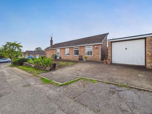 3 bedroom detached bungalow for sale in Simons Walk, Pattishall, NN12 — £270,000 • 3 bed • 1 bath • 883 ft²
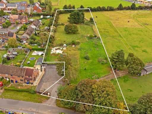 Land for sale in Self Build Land Plots At Poundfield Road, Potterspury, Towcester, Northamptonshire, NN12 — £250,000 • 1 bed • 1 bath • 1750 ft²
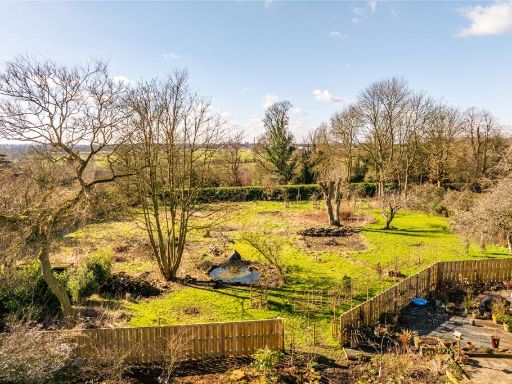 Plot for sale in The Avenue, Whitfield, Brackley, Northamptonshire, NN13 — £425,000 • 1 bed • 1 bath • 4648 ft²
Meta
- {
"@context": "https://schema.org",
"@type": "Residence",
"name": "Plot for sale in Leys Road, Pattishall, NN12",
"description": "",
"url": "https://propertypiper.co.uk/property/a4adb57b-ee66-4589-bfa5-0a27a6cc83fa",
"image": "https://image-a.propertypiper.co.uk/5a5a6b7e-4054-4a87-9467-c24e8554091f-1024.jpeg",
"address": {
"@type": "PostalAddress",
"streetAddress": "10 Leys Road, Pattishall, TOWCESTER",
"postalCode": "NN12 8JZ",
"addressLocality": "West Northamptonshire",
"addressRegion": "South Northamptonshire",
"addressCountry": "England"
},
"geo": {
"@type": "GeoCoordinates",
"latitude": 52.18161902684639,
"longitude": -1.0232762084528855
},
"numberOfRooms": 1,
"numberOfBathroomsTotal": 1,
"offers": {
"@type": "Offer",
"price": 85000,
"priceCurrency": "GBP",
"availability": "https://schema.org/InStock"
},
"additionalProperty": [
{
"@type": "PropertyValue",
"name": "Feature",
"value": "mid-20th century"
},
{
"@type": "PropertyValue",
"name": "Feature",
"value": "detached"
},
{
"@type": "PropertyValue",
"name": "Feature",
"value": "two-story"
},
{
"@type": "PropertyValue",
"name": "Feature",
"value": "solar panels"
},
{
"@type": "PropertyValue",
"name": "Feature",
"value": "garage"
},
{
"@type": "PropertyValue",
"name": "Feature",
"value": "driveway"
},
{
"@type": "PropertyValue",
"name": "Feature",
"value": "unenclosed garden"
},
{
"@type": "PropertyValue",
"name": "Feature",
"value": "needs landscaping"
},
{
"@type": "PropertyValue",
"name": "Feature",
"value": "patchy lawn"
},
{
"@type": "PropertyValue",
"name": "Feature",
"value": "external wear"
},
{
"@type": "PropertyValue",
"name": "Feature",
"value": "detached house"
},
{
"@type": "PropertyValue",
"name": "Feature",
"value": "brick exterior"
},
{
"@type": "PropertyValue",
"name": "Feature",
"value": "garage"
},
{
"@type": "PropertyValue",
"name": "Feature",
"value": "garden"
},
{
"@type": "PropertyValue",
"name": "Feature",
"value": "suburban"
}
]
}
High Res Floorplan Images
Compatible Floorplan Images
FloorplanImages Thumbnail