ME12 2HY - 3 bedroom detached bungalow for sale in Whybornes Chase, Mi…
View on Property Piper
3 bedroom detached bungalow for sale in Whybornes Chase, Minster On Sea, Sheerness, Kent, ME12
Property Details
- Price: £287500
- Bedrooms: 3
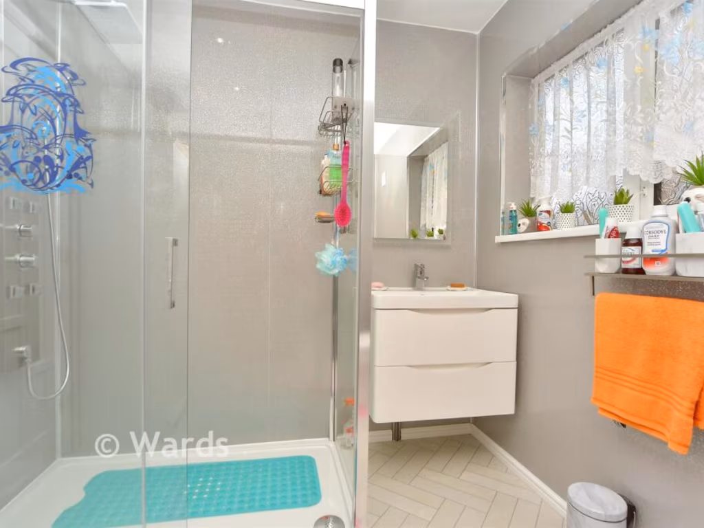
- Bathrooms: 1
- Property Type: undefined
- Property SubType: undefined
Image Descriptions
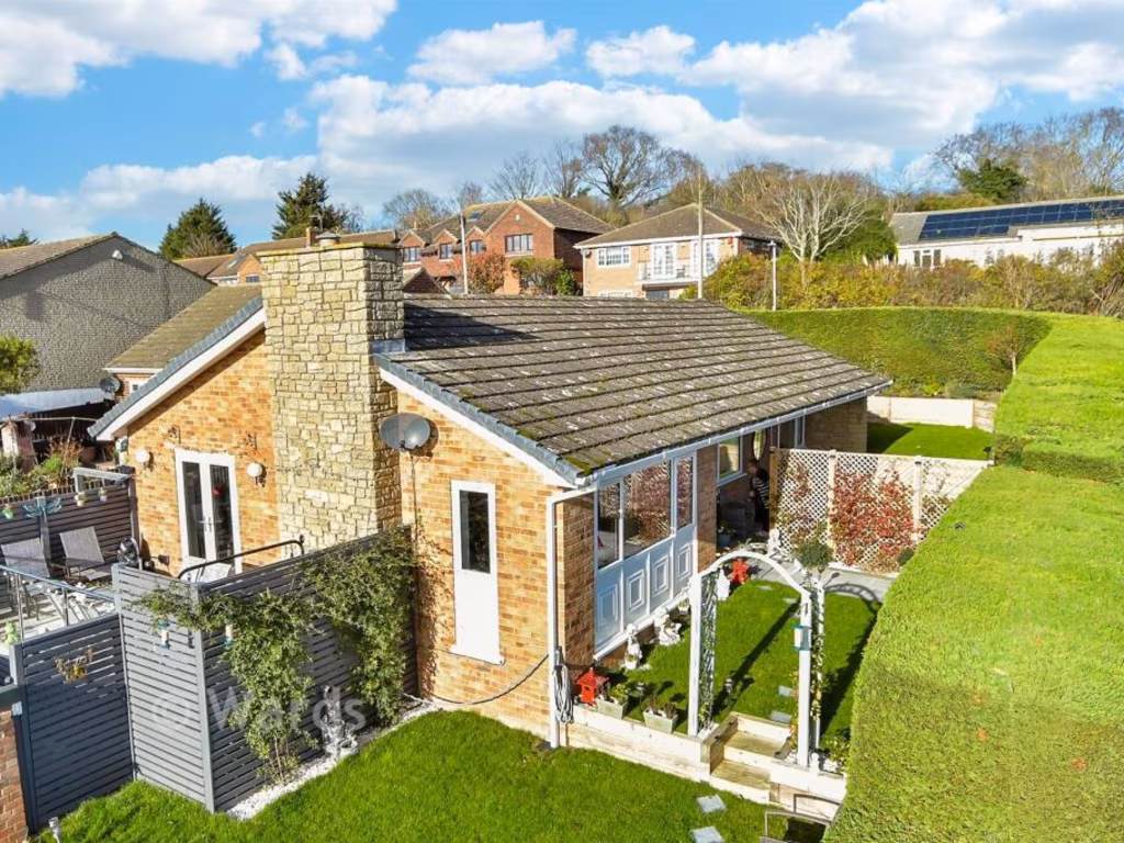
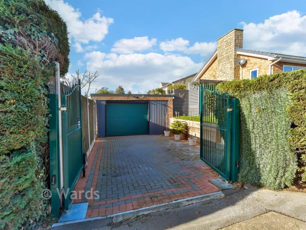
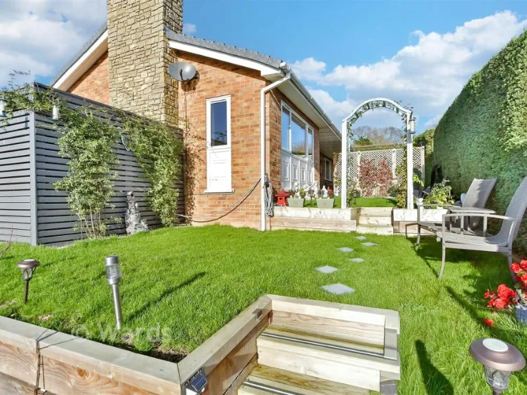
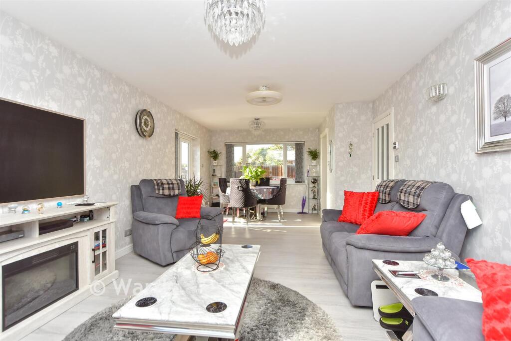
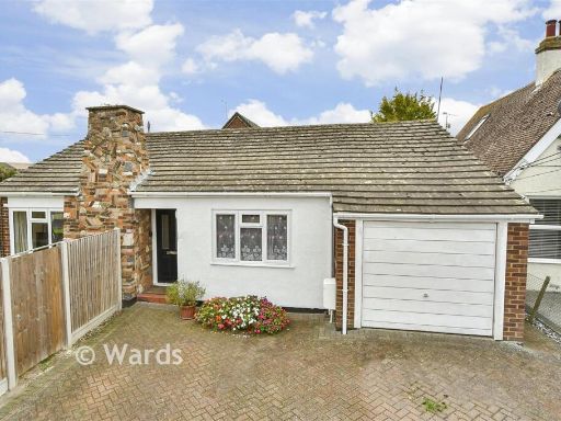
- single-family house mid-century modern
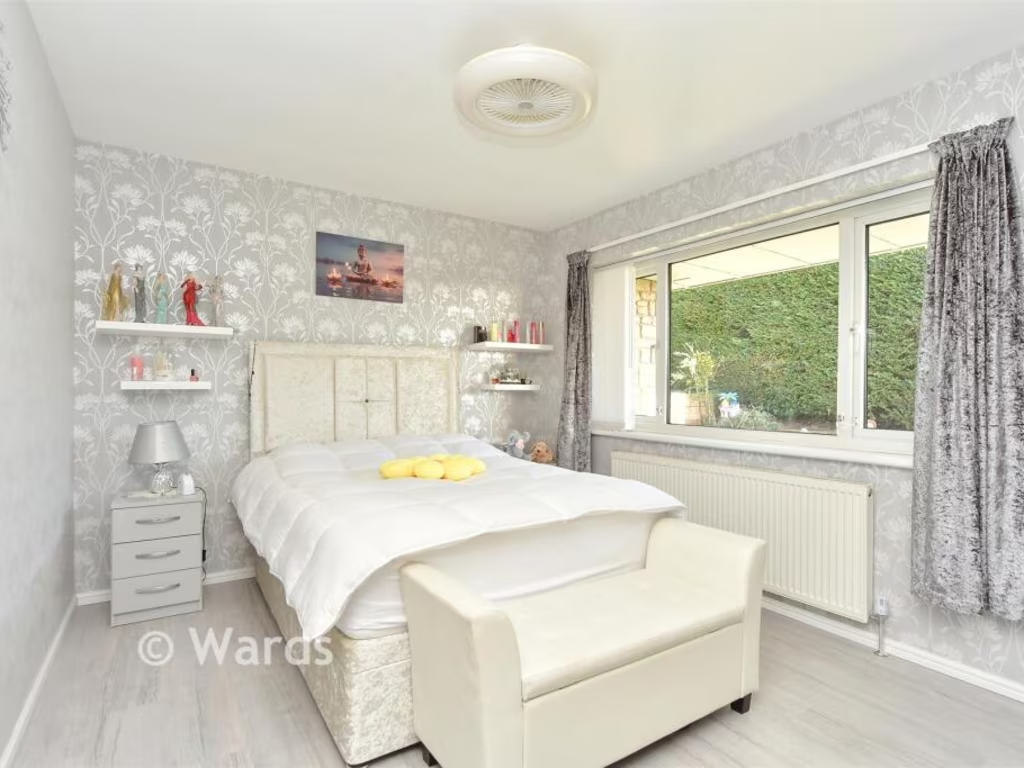
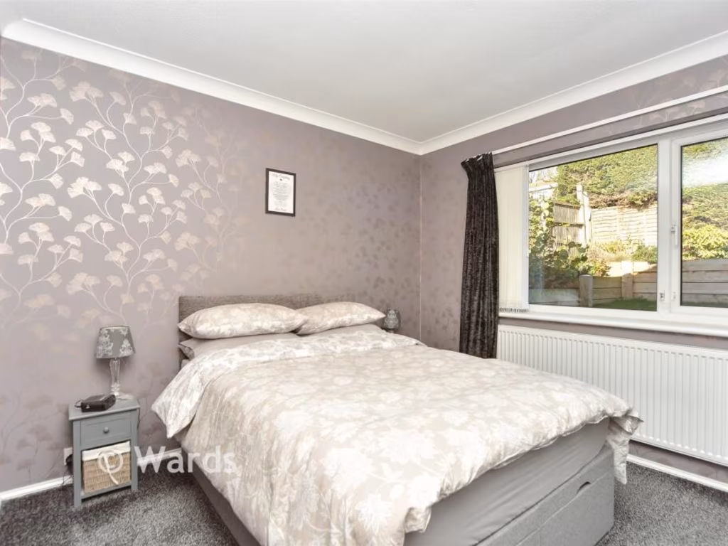
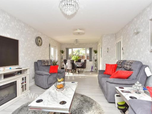
- living and dining room modern
Floorplan Description
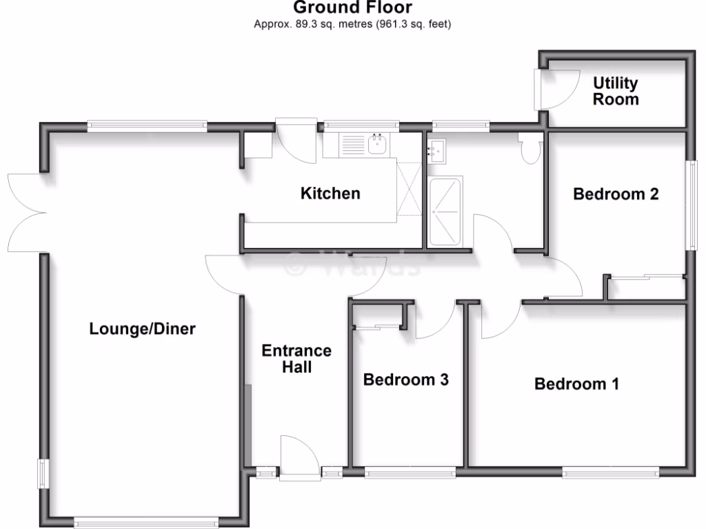
- Single-storey property with lounge/diner, kitchen, three bedrooms, entrance hall and utility room.
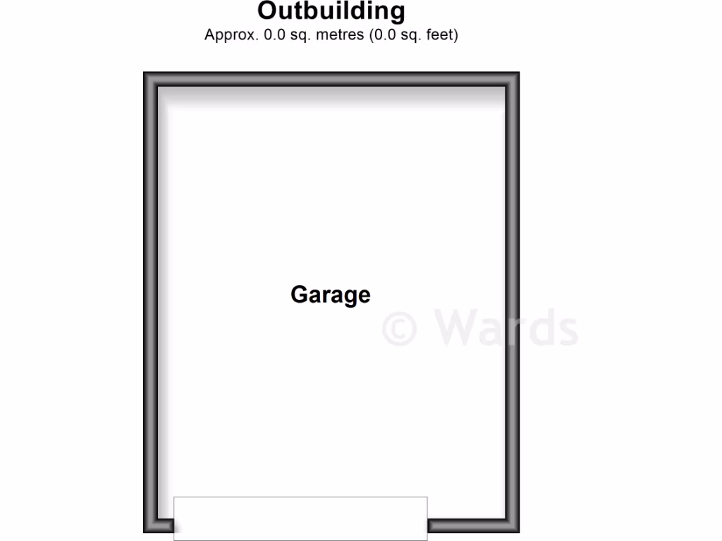
- Garage
Rooms
- Lounge/Diner:
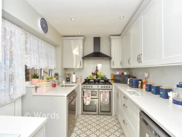
- Kitchen:
- Entrance Hall:
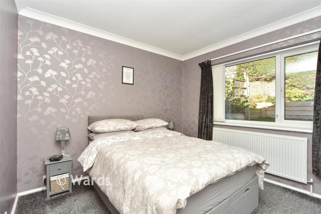
- Bedroom 3:
- Bedroom 1:
- Bedroom 2:
- Utility Room:
- Garage:
Textual Property Features
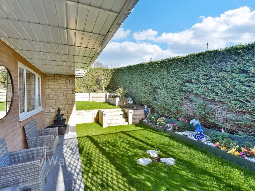
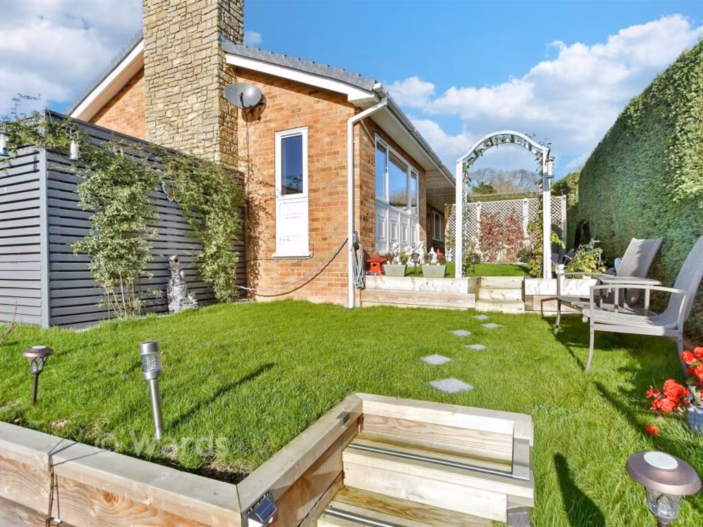
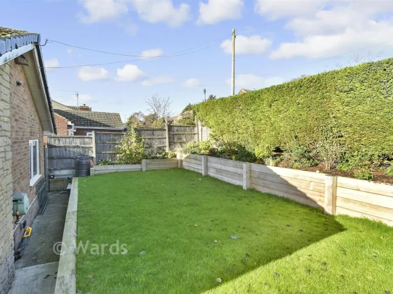
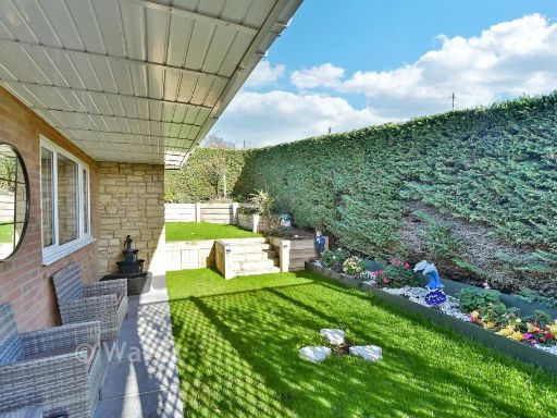
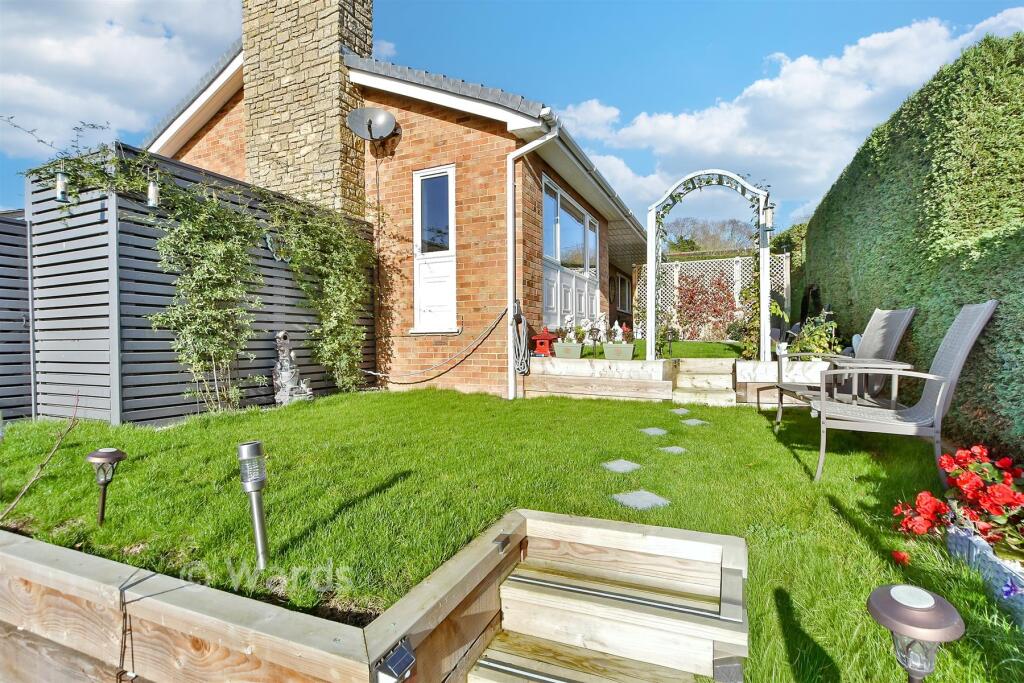
- Has Garden
- Is Retirement
- Success
Detected Visual Features
- detached house
- brick exterior
- stone chimney
- awning
- single-story
- green lawn
- suburban
- modern
- open-plan
- living room
- dining room
- bright
- garden access
- light flooring
- decorative wallpaper
- sliding doors
- natural light
EPC Details
- Fully double glazed
- Cavity wall, filled cavity
- Boiler and radiators, mains gas
- Low energy lighting in 80% of fixed outlets
- Solid, no insulation (assumed)
Nearby Schools
- St. Clement’s CE Primary School
- Kemsley Primary Academy
- Eastchurch Church of England Primary School
- Queenborough School and Nursery
- St Georges CofE (Aided) Primary School
- Minster in Sheppey Primary School
- West Minster Primary School
- Milton Court Primary Academy
- Halfway Houses Primary School
- Richmond Primary School
- St Edward's Catholic Primary School
- Regis Manor Primary School
- Iwade School
- Thistle Hill Academy
- Rose Street Primary School
- St James Church of England Primary Academy
Nearest General Shops
- Id: 4894276873
- Tags:
- Female: no
- Level: 0
- Male: yes
- Name: Snippets
- Shop: hairdresser
- Unisex: no
- TagsNormalized:
- Lat: 51.4216982
- Lon: 0.8122702
- FullGeoHash: u10sd3p3p729
- PartitionGeoHash: u10s
- Images:
- FoodStandards: null
- Distance: 500.9
,- Id: 4894276866
- Tags:
- Female: yes
- Level: 0
- Male: no
- Name: Sensu Hair Design
- Shop: hairdresser
- Unisex: no
- TagsNormalized:
- Lat: 51.4217943
- Lon: 0.8122527
- FullGeoHash: u10sd3p3wv5x
- PartitionGeoHash: u10s
- Images:
- FoodStandards: null
- Distance: 497
,- Id: 345438304
- Tags:
- Name: The co-operative
- Shop: supermarket
- TagsNormalized:
- Lat: 51.4232503
- Lon: 0.8122572
- FullGeoHash: u10sd3r6nuwu
- PartitionGeoHash: u10s
- Images:
- FoodStandards: null
- Distance: 484.3
}
Nearest Supermarkets
- Id: 60448668
- Tags:
- Addr:
- City: Sheerness
- Country: GB
- County: Kent
- Postcode: ME12 1RH
- Street: Bridge Road
- Brand: Tesco
- Brand:wikidata: Q487494
- Brand:wikipedia: en:Tesco
- Building: yes
- Contact:
- Website: https://www.tesco.com/store-locator/sheerness/bridge-road
- Designation: Sheerness Superstore
- Fhrs:
- Name: Tesco
- Roof:
- Shop: supermarket
- TagsNormalized:
- Lat: 51.4426247
- Lon: 0.7596923
- FullGeoHash: u10s9kc5n079
- PartitionGeoHash: u10s
- Images:
- FoodStandards:
- Id: 714538
- FHRSID: 714538
- LocalAuthorityBusinessID: PI/000101986/SW
- BusinessName: Tesco
- BusinessType: Retailers - supermarkets/hypermarkets
- BusinessTypeID: 7840
- AddressLine1: Bridge Road
- AddressLine2: Sheerness
- AddressLine3: Kent
- AddressLine4: null
- PostCode: ME12 1RH
- RatingValue: 5
- RatingKey: fhrs_5_en-GB
- RatingDate: 2022-05-17
- LocalAuthorityCode: 189
- LocalAuthorityName: Swale
- LocalAuthorityWebSite: http://www.swale.gov.uk
- LocalAuthorityEmailAddress: EHAdmin@MidKent.gov.uk
- Scores:
- Hygiene: 0
- Structural: 0
- ConfidenceInManagement: 0
- NewRatingPending: false
- Geocode:
- Longitude: 0.75936900000000
- Latitude: 51.44177000000000
- Distance: 3849.2
,- Id: 60556686
- Tags:
- Addr:
- Postcode: ME12 1AQ
- Street: Millenium Way
- Brand: ALDI
- Brand:wikidata: Q41171672
- Brand:wikipedia: en:Aldi
- Building: yes
- Contact:
- Website: https://stores.aldi.co.uk/sheerness/pepys-avenue
- Designation: Sheerness
- Name: Aldi
- Shop: supermarket
- Source: Bing
- TagsNormalized:
- Lat: 51.4395848
- Lon: 0.7594405
- FullGeoHash: u10s9k3121xg
- PartitionGeoHash: u10s
- Images:
- FoodStandards: null
- Distance: 3682.1
,- Id: 545366415
- Tags:
- Addr:
- Brand: Morrisons
- Brand:wikidata: Q922344
- Brand:wikipedia: en:Morrisons
- Building: yes
- Contact:
- Website: https://my.morrisons.com/storefinder/572
- Name: Morrisons
- Shop: supermarket
- TagsNormalized:
- Lat: 51.4106785
- Lon: 0.7578467
- FullGeoHash: u10s3ppbgj56
- PartitionGeoHash: u10s
- Images:
- FoodStandards: null
- Distance: 3559.3
}
Nearest Religious buildings
- Id: 60487330
- Tags:
- Alt_name: Church of St. Mary with St. Sexburgha
- Amenity: place_of_worship
- Building: yes
- Denomination: anglican
- Name: Minster Abbey
- Religion: christian
- Wikidata: Q17530102
- TagsNormalized:
- place of worship
- anglican
- christian
- church
- Lat: 51.4221304
- Lon: 0.8120072
- FullGeoHash: u10sd3p795uk
- PartitionGeoHash: u10s
- Images:
- FoodStandards: null
- Distance: 472.5
,- Id: 60555706
- Tags:
- Amenity: place_of_worship
- Building: yes
- Denomination: roman_catholic
- Name: Minster Roman Catholic Church
- Religion: christian
- Source: auto_os_street_view
- TagsNormalized:
- place of worship
- catholic
- roman catholic
- church
- christian
- Lat: 51.4200386
- Lon: 0.802527
- FullGeoHash: u10sd28rkjzt
- PartitionGeoHash: u10s
- Images:
- FoodStandards: null
- Distance: 369.7
,- Id: 60483613
- Tags:
- Amenity: place_of_worship
- Building: yes
- Denomination: methodist
- Name: Minster Methodist Church
- Religion: christian
- Source: OS_OpenData_StreetView
- TagsNormalized:
- place of worship
- methodist
- church
- christian
- Lat: 51.4243957
- Lon: 0.8092721
- FullGeoHash: u10sd3t2c6jj
- PartitionGeoHash: u10s
- Images:
- FoodStandards: null
- Distance: 323.1
}
Nearest Medical buildings
- Id: 9249187160
- Tags:
- Addr:
- Housename: Sheppey Community Hospital
- Postcode: ME12 3LT
- Street: Plover Road
- Amenity: hospital
- Contact:
- Healthcare: hospital
- Name: Sheppey community Hospital
- Opening_hours: Mo-Su 09:00-21:00
- TagsNormalized:
- Lat: 51.4154395
- Lon: 0.7931429
- FullGeoHash: u10s6pcs9sd5
- PartitionGeoHash: u10s
- Images:
- FoodStandards: null
- Distance: 1181
,- Id: 4894276842
- Tags:
- Amenity: pharmacy
- Dispensing: yes
- Level: 0
- Name: Minster Pharmacy
- TagsNormalized:
- Lat: 51.420286
- Lon: 0.7981682
- FullGeoHash: u10sd0v0ysj3
- PartitionGeoHash: u10s
- Images:
- FoodStandards: null
- Distance: 572.3
,- Id: 60553882
- Tags:
- Amenity: doctors
- Building: yes
- Healthcare:
- Speciality: Shiva Medical Centre
- Mapseg:
- Source: auto_os_street_view
- TagsNormalized:
- doctor
- doctors
- health
- healthcare
- Lat: 51.420997
- Lon: 0.7980782
- FullGeoHash: u10sd0vjh8d5
- PartitionGeoHash: u10s
- Images:
- FoodStandards: null
- Distance: 542.6
,- Id: 4894276850
- Tags:
- Amenity: veterinary
- Name: Wellpets Animal Hospital
- TagsNormalized:
- Lat: 51.4205033
- Lon: 0.7985784
- FullGeoHash: u10sd0vd0hx4
- PartitionGeoHash: u10s
- Images:
- FoodStandards: null
- Distance: 535.6
}
Nearest Airports
- Id: 103894219
- Tags:
- Aerodrome: international
- Aeroway: aerodrome
- Iata: SEN
- Icao: EGMC
- Name: London Southend Airport
- Old_name: Southend Municipal Airport
- Ref: SEN
- Wikidata: Q1415441
- TagsNormalized:
- airport
- international airport
- Lat: 51.5701749
- Lon: 0.6924624
- FullGeoHash: u10mru04p937
- PartitionGeoHash: u10m
- Images:
- FoodStandards: null
- Distance: 18145.9
}
Nearest Leisure Facilities
- Id: 31119832
- Tags:
- TagsNormalized:
- Lat: 51.4207164
- Lon: 0.7968996
- FullGeoHash: u10sd0u73h73
- PartitionGeoHash: u10s
- Images:
- FoodStandards: null
- Distance: 630.1
,- Id: 905411100
- Tags:
- TagsNormalized:
- Lat: 51.4176334
- Lon: 0.8032387
- FullGeoHash: u10sd22ckvd4
- PartitionGeoHash: u10s
- Images:
- FoodStandards: null
- Distance: 600.5
,- Id: 905411099
- Tags:
- TagsNormalized:
- Lat: 51.419336
- Lon: 0.8083364
- FullGeoHash: u10sd2se7dgq
- PartitionGeoHash: u10s
- Images:
- FoodStandards: null
- Distance: 446.7
,- Id: 965656939
- Tags:
- TagsNormalized:
- Lat: 51.4253433
- Lon: 0.803104
- FullGeoHash: u10sd38y3dv9
- PartitionGeoHash: u10s
- Images:
- FoodStandards: null
- Distance: 313.5
,- Id: 31067818
- Tags:
- Leisure: park
- Name: The Glen
- TagsNormalized:
- Lat: 51.4250023
- Lon: 0.8033019
- FullGeoHash: u10sd38uq71r
- PartitionGeoHash: u10s
- Images:
- FoodStandards: null
- Distance: 273.8
}
Nearest Tourist attractions
- Id: 91394917
- Tags:
- Source: Bing
- Tourism: caravan_site
- TagsNormalized:
- Lat: 51.4192379
- Lon: 0.8367806
- FullGeoHash: u10se096f2sv
- PartitionGeoHash: u10s
- Images:
- FoodStandards: null
- Distance: 2220.2
,- Id: 517320298
- Tags:
- Name: Parklands Village
- Tourism: resort
- TagsNormalized:
- Lat: 51.4333538
- Lon: 0.7966043
- FullGeoHash: u10sd5hj40p4
- PartitionGeoHash: u10s
- Images:
- FoodStandards: null
- Distance: 1311.5
,- Id: 123104922
- Tags:
- Building: yes
- Historic: yes
- Name: Minster Abbey Gatehouse Museum
- Source: survey
- Source:shape: Bing
- Tourism: museum
- Wikidata: Q113369958
- TagsNormalized:
- Lat: 51.422257
- Lon: 0.8113998
- FullGeoHash: u10sd3nu6grx
- PartitionGeoHash: u10s
- Images:
- FoodStandards: null
- Distance: 428.6
}
Nearest Train stations
- Id: 3726061852
- Tags:
- Addr:
- Postcode: ME10 3ED
- Street: St. Michaels Road
- Name: Sittingbourne
- Naptan:
- Network: National Rail
- Platforms: 3
- Public_transport: station
- Railway: station
- Ref:
- Train: yes
- Wheelchair: yes
- Wikidata: Q1919614
- Wikipedia: en:Sittingbourne railway station
- TagsNormalized:
- Lat: 51.342078
- Lon: 0.7351464
- FullGeoHash: u10s0dx361hb
- PartitionGeoHash: u10s
- Images:
- FoodStandards: null
- Distance: 10218.9
,- Id: 2315856087
- Tags:
- Name: Sittingbourne Viaduct
- Public_transport: station
- Railway: station
- Train: yes
- Usage: tourism
- Wheelchair: no
- TagsNormalized:
- Lat: 51.345203
- Lon: 0.7336166
- FullGeoHash: u10s0en5qx84
- PartitionGeoHash: u10s
- Images:
- FoodStandards: null
- Distance: 9967.2
,- Id: 90219136
- Tags:
- Name: Kemsley Down
- Network: Sittingbourne and Kemsley Light Railway
- Operator: Sittingbourne and Kemsley Light Railway
- Public_transport: station
- Railway: station
- Tourism: heritage_railway
- Train: yes
- Usage: tourism
- TagsNormalized:
- station
- railway
- tourism
- train
- Lat: 51.3618635
- Lon: 0.7567947
- FullGeoHash: u10s1nphd971
- PartitionGeoHash: u10s
- Images:
- FoodStandards: null
- Distance: 7573.4
,- Id: 855651597
- Tags:
- Name: Swale
- Naptan:
- Network: National Rail
- Old_name: Kings Ferry Bridge Halt;Swale Halt
- Public_transport: station
- Railway: station
- Ref:
- Train: yes
- Wikidata: Q2191551
- Wikipedia: en:Swale railway station
- TagsNormalized:
- Lat: 51.3889653
- Lon: 0.7468492
- FullGeoHash: u10s2gpf6v7n
- PartitionGeoHash: u10s
- Images:
- FoodStandards: null
- Distance: 5536.9
,- Id: 29704570
- Tags:
- Name: Queenborough
- Naptan:
- Network: National Rail
- Public_transport: station
- Railway: station
- Ref:
- Wikidata: Q2323119
- Wikipedia: en:Queenborough railway station
- TagsNormalized:
- Lat: 51.4159485
- Lon: 0.7497508
- FullGeoHash: u10s3pczw7qx
- PartitionGeoHash: u10s
- Images:
- FoodStandards: null
- Distance: 3928.2
}
Nearest Hotels
- Id: 60552612
- Tags:
- Addr:
- Postcode: ME11 5AQ
- Street: High Street
- Alt_name: Queen Phillipa Hotel
- Building: yes
- Fhrs:
- Authority: Swale
- Id: 730141
- Inspectiondate: 2016-07-21
- Rating: 4
- Name: The Queen Philippa Bed And Breakfast
- Source: OS_Street_View
- Stars: 4
- Tourism: hotel
- TagsNormalized:
- Lat: 51.4163135
- Lon: 0.7473973
- FullGeoHash: u10s9001xxeb
- PartitionGeoHash: u10s
- Images:
- FoodStandards: null
- Distance: 4080.9
,- Id: 9664484167
- Tags:
- Addr:
- City: Sheerness
- Country: GB
- County: Kent
- Housenumber: 29
- Postcode: ME12 1AB
- Street: Broadway
- Fhrs:
- Name: The Royal Hotel
- Tourism: hotel
- TagsNormalized:
- Lat: 51.4403429
- Lon: 0.7640111
- FullGeoHash: u10s9kkmdwzv
- PartitionGeoHash: u10s
- Images:
- FoodStandards: null
- Distance: 3458.8
,- Id: 348836535
- Tags:
- Name: The Abbey Hotel
- Tourism: hotel
- TagsNormalized:
- Lat: 51.4321197
- Lon: 0.7981914
- FullGeoHash: u10sd4vjz4n8
- PartitionGeoHash: u10s
- Images:
- FoodStandards: null
- Distance: 1139.6
}
Tags
- detached house
- brick exterior
- stone chimney
- awning
- single-story
- green lawn
- suburban
- modern
- open-plan
- living room
- dining room
- bright
- garden access
- light flooring
- decorative wallpaper
- sliding doors
- natural light
Local Market Stats
- Average Price/sqft: £286
- Avg Income: £38300
- Rental Yield: 4.7%
- Social Housing: 3%
- Planning Success Rate: 81%
Similar Properties
 2 bedroom detached bungalow for sale in Minster Road, Minster On Sea, Sheerness, Kent, ME12 — £231,500 • 2 bed • 1 bath • 862 ft²
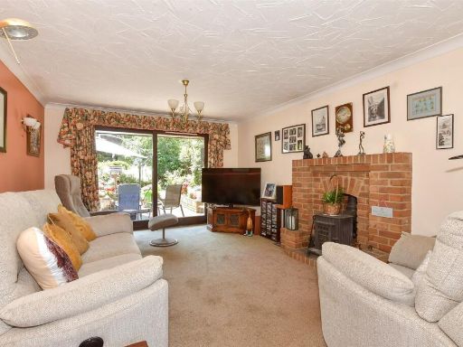 3 bedroom chalet for sale in Hillside Road, Minster-On-Sea, Sheerness, Kent, ME12 — £281,000 • 3 bed • 1 bath • 985 ft²
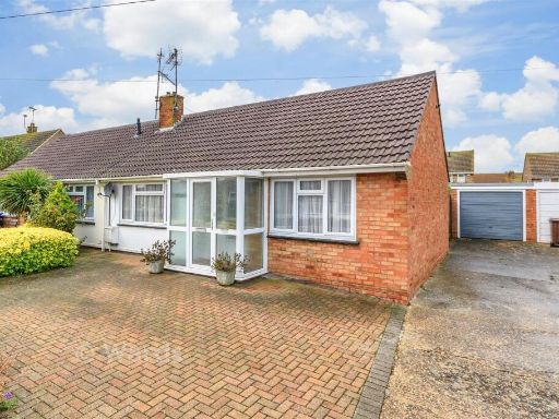 2 bedroom semi-detached bungalow for sale in Kent Avenue, Minster On Sea, Sheerness, Kent, ME12 — £185,500 • 2 bed • 1 bath • 571 ft²
 3 bedroom semi-detached house for sale in Nelson Avenue, Minster On Sea, Sheerness, Kent, ME12 — £215,000 • 3 bed • 1 bath • 926 ft²
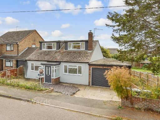 3 bedroom chalet for sale in Nelson Avenue, Minster On Sea, Sheerness, Kent, ME12 — £280,500 • 3 bed • 1 bath • 1240 ft²
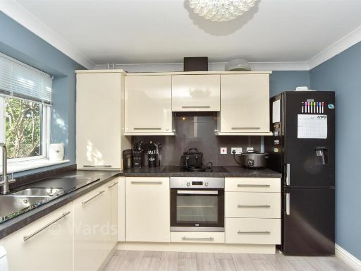 3 bedroom chalet for sale in Union Road, Minster On Sea, Sheerness, Kent, ME12 — £208,500 • 3 bed • 3 bath • 1034 ft²
Meta
- {
"@context": "https://schema.org",
"@type": "Residence",
"name": "3 bedroom detached bungalow for sale in Whybornes Chase, Mi…",
"description": "",
"url": "https://propertypiper.co.uk/property/a25e95a7-06ea-4a3e-8078-30e4d0fc6ed2",
"image": "https://image-a.propertypiper.co.uk/fcf0a038-42c1-4d3b-8ee1-52a62b8e4714-1024.jpeg",
"address": {
"@type": "PostalAddress",
"streetAddress": "LE DOLOMITI WHYBORNES CHASE MINSTER ON SEA SHEERNESS",
"postalCode": "ME12 2HY",
"addressLocality": "Swale",
"addressRegion": "Sittingbourne and Sheppey",
"addressCountry": "England"
},
"geo": {
"@type": "GeoCoordinates",
"latitude": 51.42287838141215,
"longitude": 0.805298727535175
},
"numberOfRooms": 3,
"numberOfBathroomsTotal": 1,
"floorSize": {
"@type": "QuantitativeValue",
"value": 883,
"unitCode": "FTK"
},
"offers": {
"@type": "Offer",
"price": 287500,
"priceCurrency": "GBP",
"availability": "https://schema.org/InStock"
},
"additionalProperty": [
{
"@type": "PropertyValue",
"name": "Feature",
"value": "detached house"
},
{
"@type": "PropertyValue",
"name": "Feature",
"value": "brick exterior"
},
{
"@type": "PropertyValue",
"name": "Feature",
"value": "stone chimney"
},
{
"@type": "PropertyValue",
"name": "Feature",
"value": "awning"
},
{
"@type": "PropertyValue",
"name": "Feature",
"value": "single-story"
},
{
"@type": "PropertyValue",
"name": "Feature",
"value": "green lawn"
},
{
"@type": "PropertyValue",
"name": "Feature",
"value": "suburban"
},
{
"@type": "PropertyValue",
"name": "Feature",
"value": "modern"
},
{
"@type": "PropertyValue",
"name": "Feature",
"value": "open-plan"
},
{
"@type": "PropertyValue",
"name": "Feature",
"value": "living room"
},
{
"@type": "PropertyValue",
"name": "Feature",
"value": "dining room"
},
{
"@type": "PropertyValue",
"name": "Feature",
"value": "bright"
},
{
"@type": "PropertyValue",
"name": "Feature",
"value": "garden access"
},
{
"@type": "PropertyValue",
"name": "Feature",
"value": "light flooring"
},
{
"@type": "PropertyValue",
"name": "Feature",
"value": "decorative wallpaper"
},
{
"@type": "PropertyValue",
"name": "Feature",
"value": "sliding doors"
},
{
"@type": "PropertyValue",
"name": "Feature",
"value": "natural light"
}
]
}
High Res Floorplan Images
Compatible Floorplan Images
FloorplanImages Thumbnail