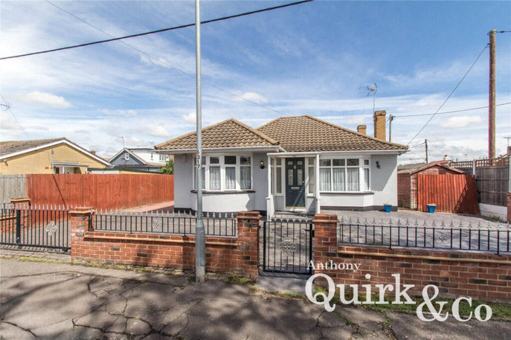
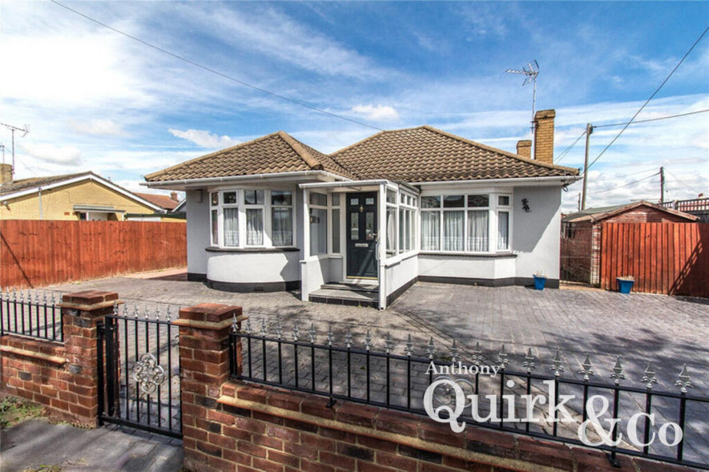
SS8 7JY - 2 bedroom detached bungalow for sale in Crescent Road, Canv…
View on Property Piper
2 bedroom detached bungalow for sale in Crescent Road, Canvey Island, SS8
Property Details
- Price: £350000
- Bedrooms: 2
- Bathrooms: 1
- Property Type: undefined
- Property SubType: undefined
Image Descriptions
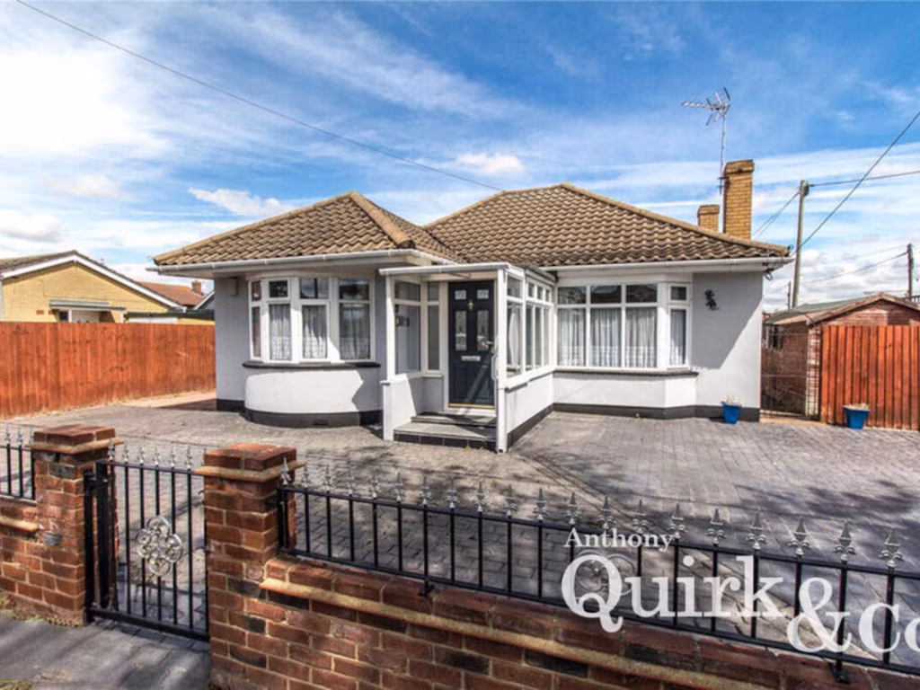
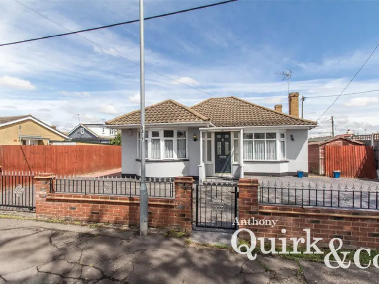
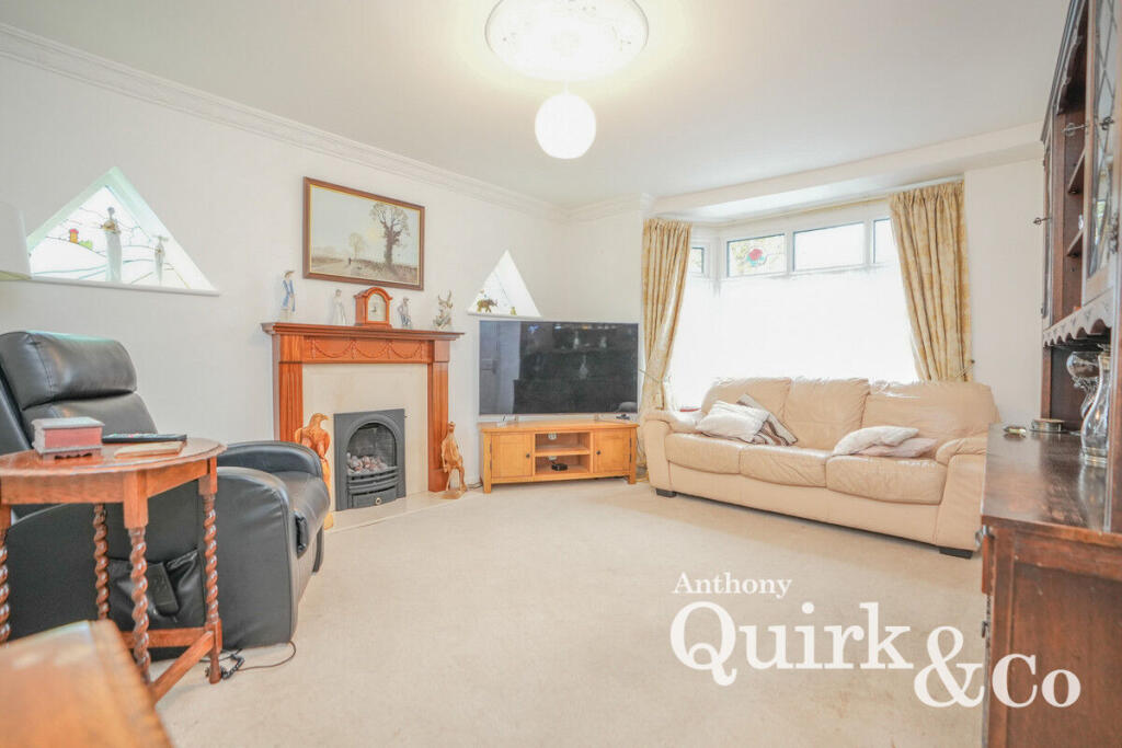
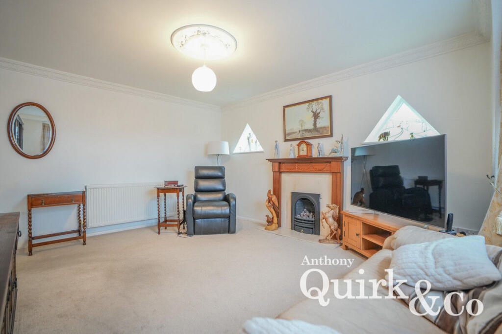
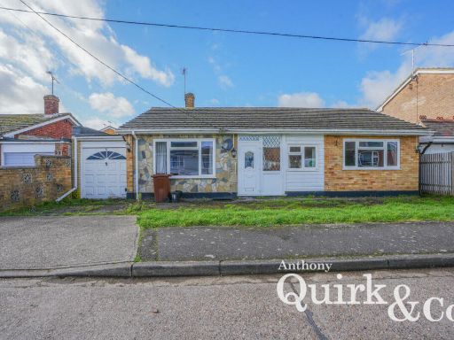
- bungalow mid-20th century
- living room Modern
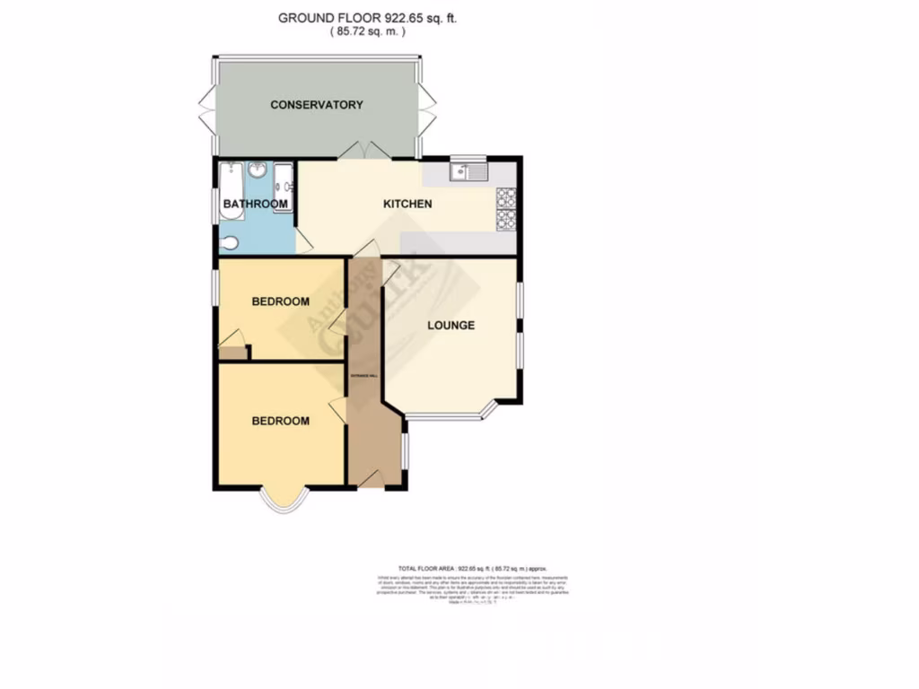
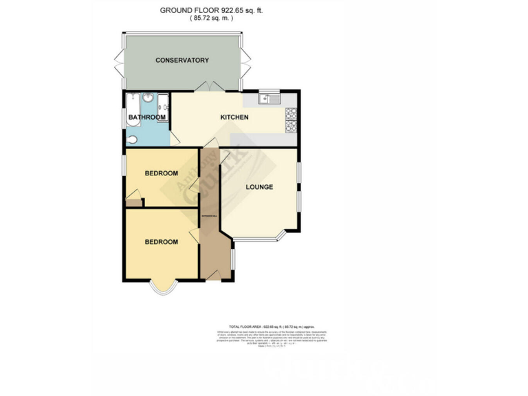
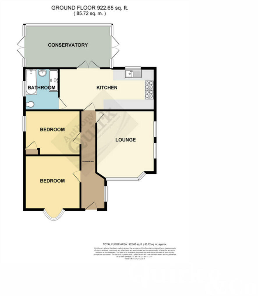
Rooms
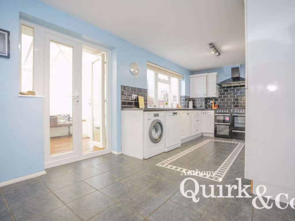
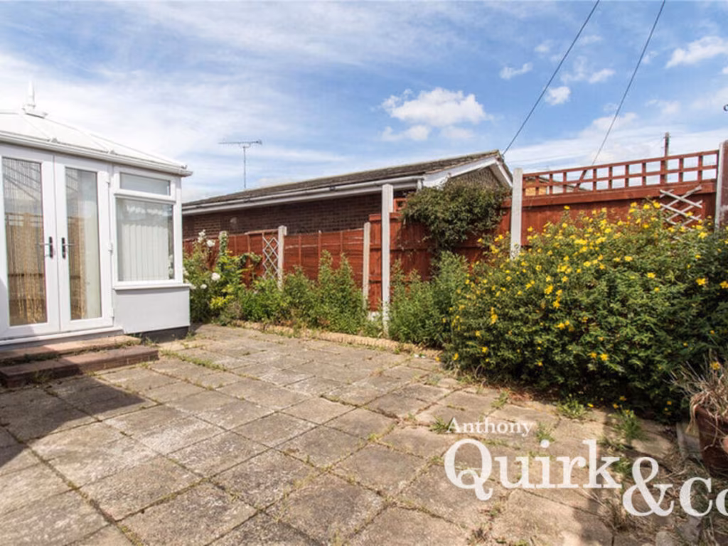
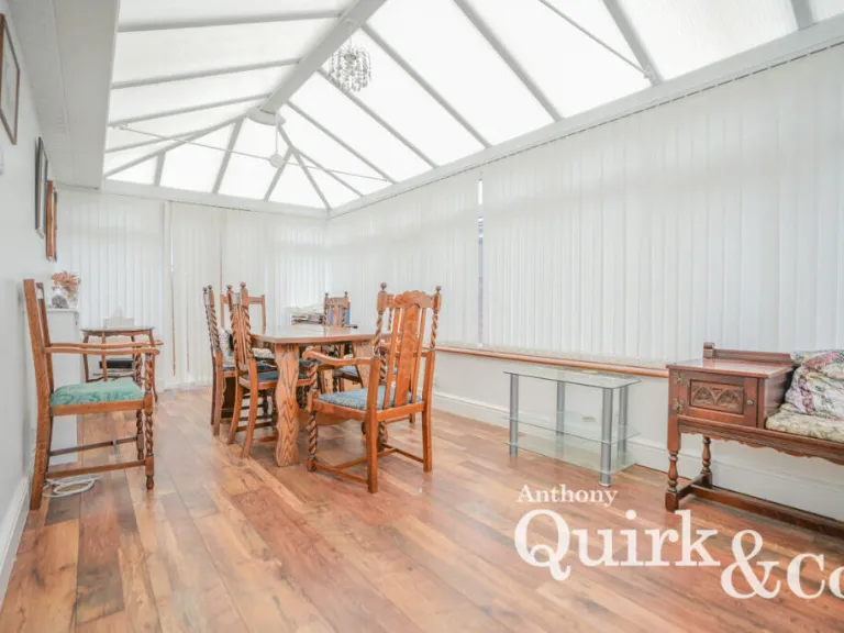
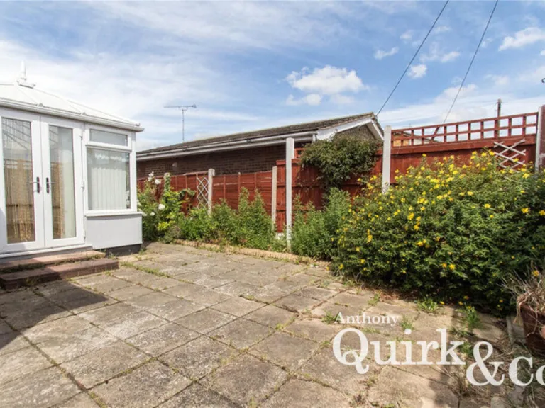
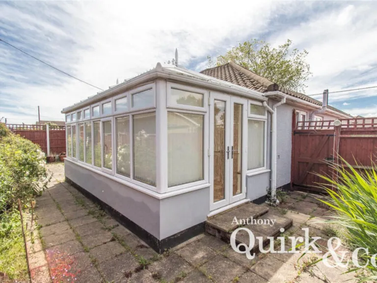
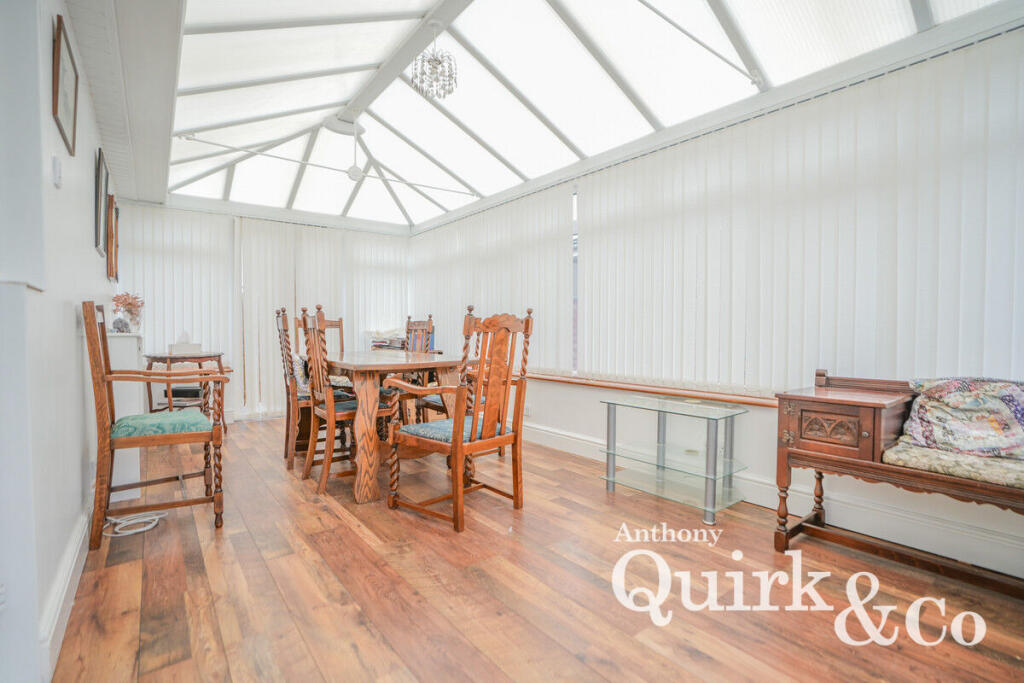
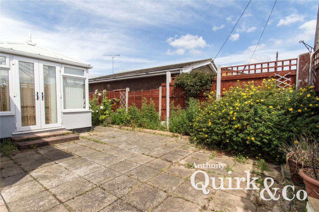
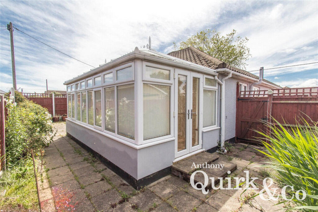
- CONSERVATORY:
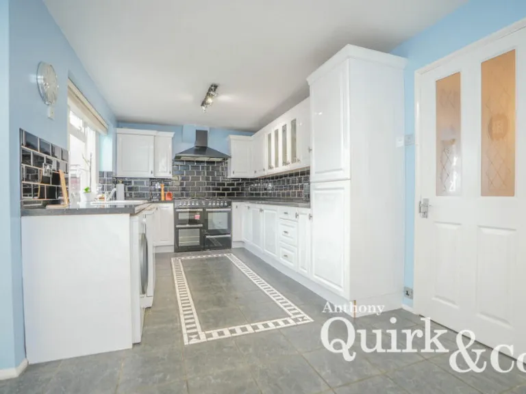
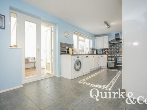
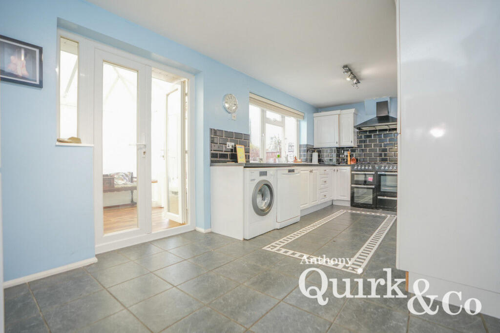
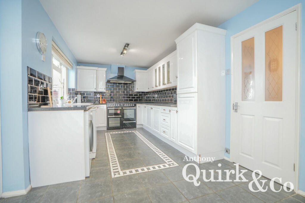
- KITCHEN:
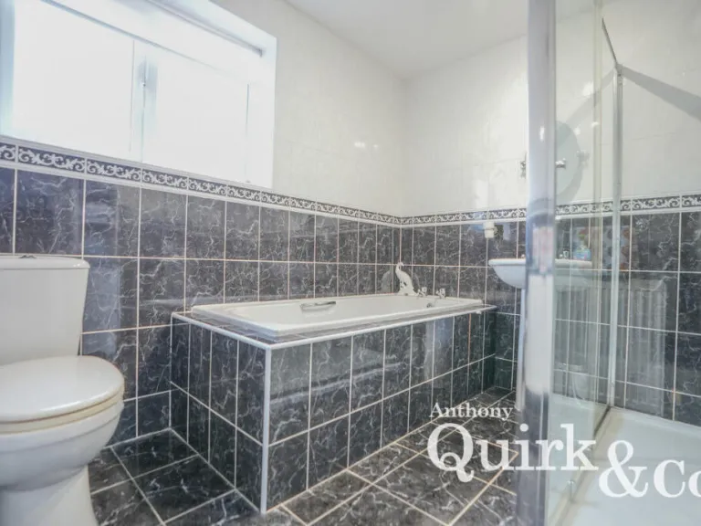
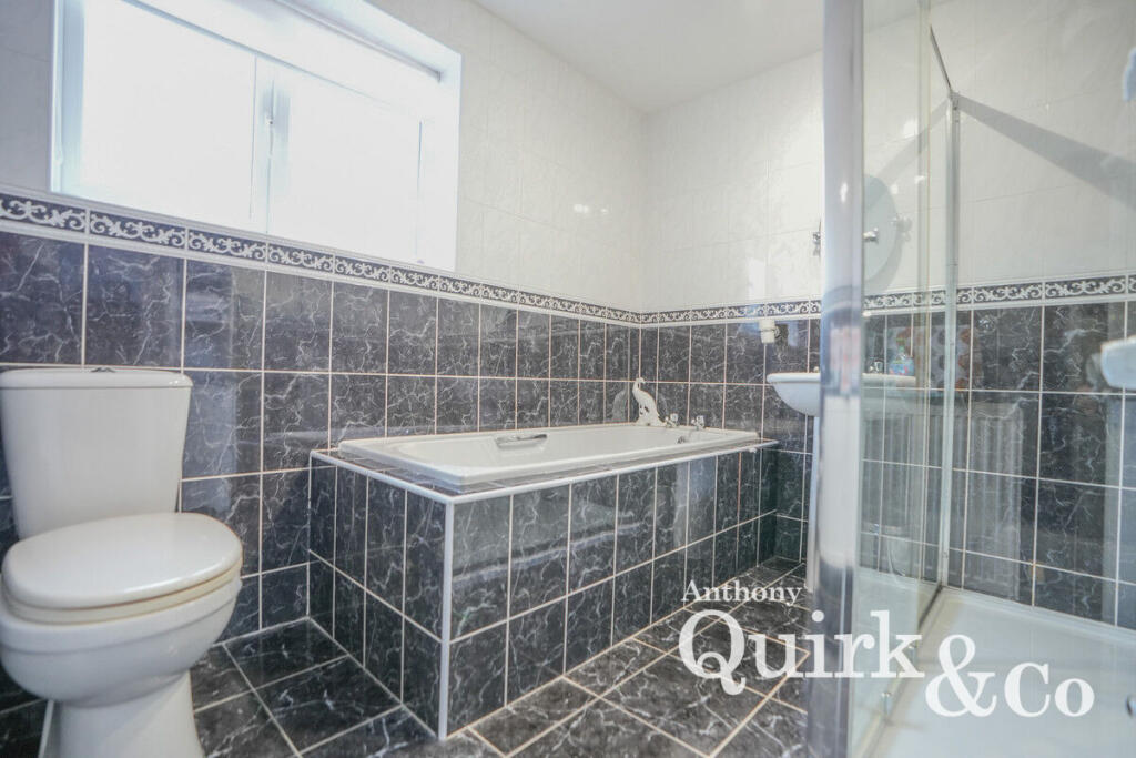
- BATHROOM:
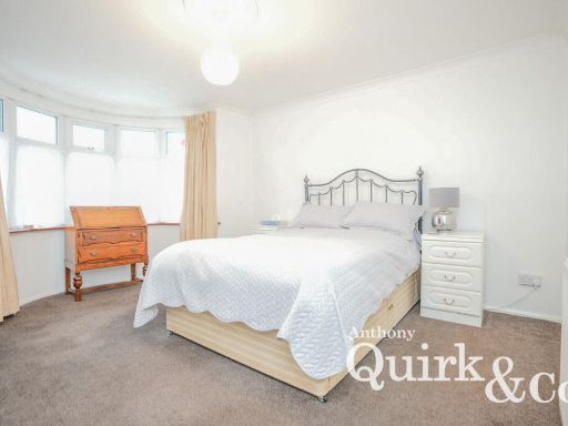
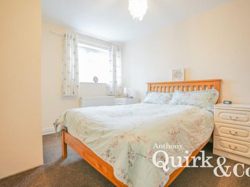
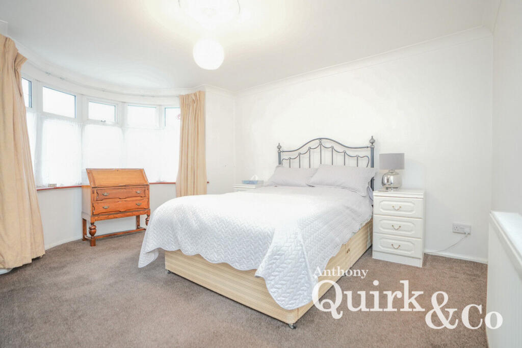
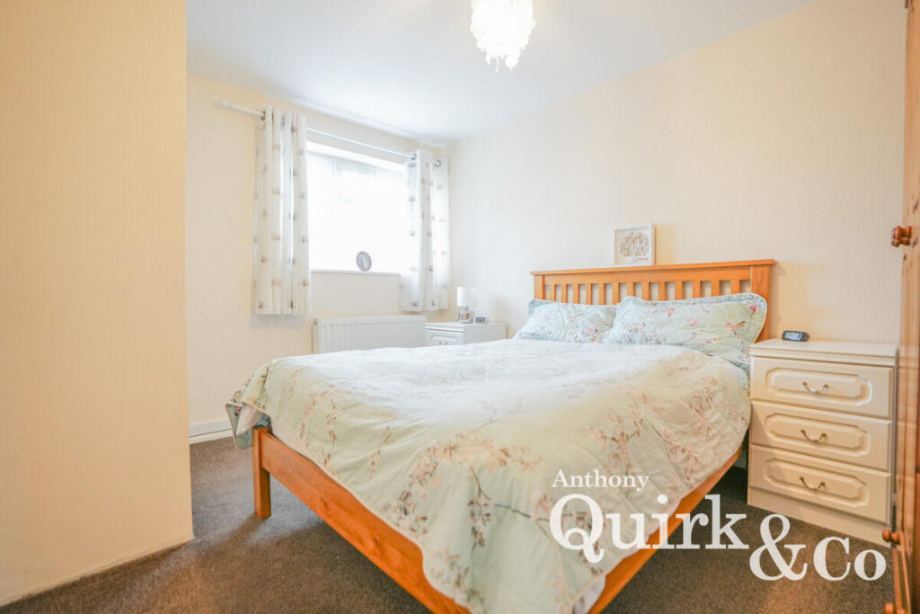
- BEDROOM:
- BEDROOM:
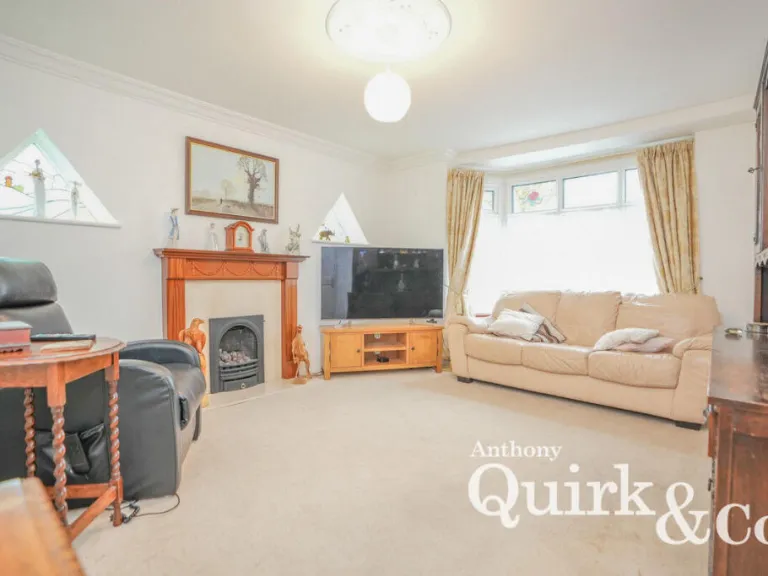
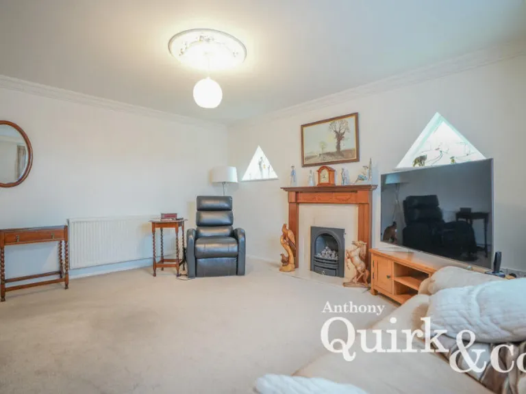
- LOUNGE:
Textual Property Features
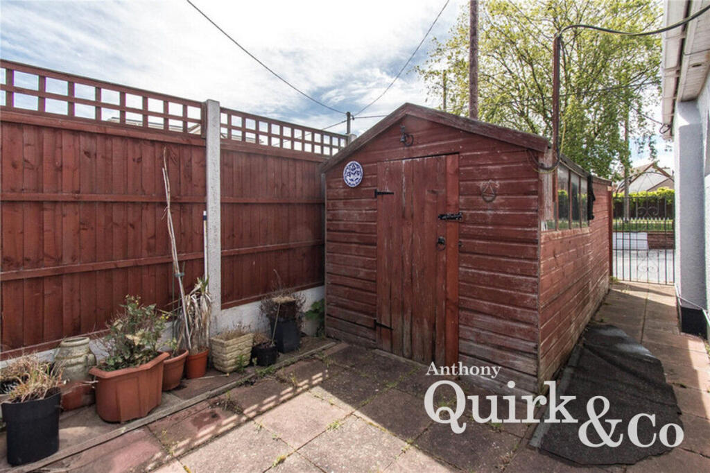
- Has Garden
- Chain Free
- Success
Detected Visual Features
- bungalow
- mid-20th century
- detached
- garage
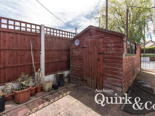
- garden
- off-street parking
- driveway
- gable roof
- fenced yard
- modern style
- corner fireplace
- bay window
- standard ceiling
- beige walls
- natural light
EPC Details
- Fully double glazed
- Solid brick, as built, no insulation (assumed)
- Boiler and radiators, mains gas
- No low energy lighting
- Suspended, no insulation (assumed)
Nearby Schools
- Lubbins Park Primary Academy
- Canvey Junior School
- Castle View School
- St Katherine's Church of England Primary School
- Belfairs Academy
- The King John School
- Fairways Primary School
- William Read Primary Academy
- The Cornelius Vermuyden School
- Leigh North Street Primary School
- Hadleigh Junior School
- Westwood Academy
- Kents Hill Junior School
- Kingston Primary School
- Leigh Beck Junior School
- Canvey Island Infant School and Nursery
- West Leigh Infant School
- South Benfleet Primary School
- Hadleigh Infant and Nursery School
- Thundersley Primary School
- The Deanes
- Leigh Beck Infant School and Nursery Academy
- St Joseph's Catholic Primary School
- Northwick Park Primary and Nursery Academy
- Winter Gardens Academy
- St. Michael's School
- West Leigh Junior School
- Kents Hill Infant Academy
Nearest Bars And Restaurants
- Id: 702967802
- Tags:
- Amenity: pub
- Fixme: check location
- Name: The Monico
- Source: http://www.geograph.org.uk/photo/333397
- TagsNormalized:
- Lat: 51.5126041
- Lon: 0.595889
- FullGeoHash: u10mj99ftjrh
- PartitionGeoHash: u10m
- Images:
- FoodStandards: null
- Distance: 788.4
,- Id: 1225463843
- Tags:
- Amenity: fast_food
- Cuisine: fish_and_chips
- Drive_through: no
- Name: Arthur Greens
- TagsNormalized:
- Lat: 51.5126942
- Lon: 0.5971805
- FullGeoHash: u10mj9dg5q4n
- PartitionGeoHash: u10m
- Images:
- FoodStandards: null
- Distance: 716.9
,- Id: 9036297109
- Tags:
- Addr:
- City: Canvey Island
- Housenumber: 31-33
- Postcode: SS8 7DN
- Street: Eastern Esplanade
- Amenity: fast_food
- Cuisine: fish_and_chips
- Drive_through: no
- Name: Bruno's Fish and Chips
- Opening_hours: Mo off; Tu-Th 12:00-21:00; Fr-Sa 12:00-21:30; Su 12:00-18:00
- Phone: +44 1268 971736
- Website: https://brunosfishandchips.co.uk/
- TagsNormalized:
- Lat: 51.5127356
- Lon: 0.5976514
- FullGeoHash: u10mj9e5qmcj
- PartitionGeoHash: u10m
- Images:
- FoodStandards: null
- Distance: 691.3
,- Id: 701598563
- Tags:
- Amenity: pub
- Name: The Windjammer
- Source: OS OpenData StreetView
- Source:name: http://www.geograph.org.uk/photo/1207269
- TagsNormalized:
- Lat: 51.5131976
- Lon: 0.6007798
- FullGeoHash: u10mj9tqphjc
- PartitionGeoHash: u10m
- Images:
- FoodStandards: null
- Distance: 522.6
,- Id: 1808256749
- Tags:
- TagsNormalized:
- Lat: 51.5187394
- Lon: 0.6104709
- FullGeoHash: u10mjfsw3j05
- PartitionGeoHash: u10m
- Images:
- FoodStandards: null
- Distance: 449.3
}
Nearest General Shops
- Id: 465455656
- Tags:
- Landuse: retail
- Shop: garden_centre
- TagsNormalized:
- Lat: 51.5238324
- Lon: 0.5560348
- FullGeoHash: u10mhesuhd98
- PartitionGeoHash: u10m
- Images:
- FoodStandards: null
- Distance: 3422.7
,- Id: 4887749819
- Tags:
- Addr:
- Country: GB
- Housename: Matrix House
- Housenumber: 12-16
- Place: Canvey Island
- Postcode: SS8 9DE
- Street: Lionel Road
- Description: High quality Website Design, Graphic Design and Marketing in Essex
- Email: info@essexwebstudio.co.uk
- Name: Essex Web Studio
- Note: All major credit and debit cards, paypal, bank transfer
- Opening_hours: Mo-Fr 09:00-17:30
- Operator: Gary Sumpter
- Phone: +44 1268 923477
- Shop: web_design
- Website: https://www.essexwebstudio.co.uk/
- TagsNormalized:
- Lat: 51.5216579
- Lon: 0.5918999
- FullGeoHash: u10mj7pp2m0s
- PartitionGeoHash: u10m
- Images:
- FoodStandards: null
- Distance: 989.1
,- Id: 976477195
- Tags:
- Building: yes
- Shop: seafood
- TagsNormalized:
- Lat: 51.5122896
- Lon: 0.5958818
- FullGeoHash: u10mj99bv4c8
- PartitionGeoHash: u10m
- Images:
- FoodStandards: null
- Distance: 812.5
}
Nearest Grocery shops
- Id: 547865497
- Tags:
- Brand: The Co-operative Food
- Brand:wikidata: Q107617274
- Building: yes
- Name: The Co-operative Food
- Shop: supermarket
- TagsNormalized:
- the co-operative food
- food
- shop
- Lat: 51.5198646
- Lon: 0.5804693
- FullGeoHash: u10mj4ysvyv7
- PartitionGeoHash: u10m
- Images:
- FoodStandards: null
- Distance: 1678.8
,- Id: 924810536
- Tags:
- Addr:
- Country: GB
- Housenumber: 20-22
- Postcode: SS8 8DY
- Street: Dovervelt Road
- Brand: Morrisons Daily
- Brand:wikidata: Q99752411
- Building: retail
- Building:levels: 2
- Contact:
- Website: https://my.morrisons.com/storefinder/31532
- Fhrs:
- Height: 6
- Name: Morrisons Daily
- Operator: McColl's
- Operator:website: https://www.mccolls.co.uk/storelocator/canvey-island-dovervelt-rd/
- Operator:wikidata: Q16997477
- Shop: convenience
- TagsNormalized:
- morrisons
- morrisons daily
- retail
- convenience
- shop
- Lat: 51.5261634
- Lon: 0.5997202
- FullGeoHash: u10mjsh9wmpc
- PartitionGeoHash: u10m
- Images:
- FoodStandards:
- Id: 1057292
- FHRSID: 1057292
- LocalAuthorityBusinessID: 18/00026/COMM
- BusinessName: Morrisons Daily
- BusinessType: Retailers - other
- BusinessTypeID: 4613
- AddressLine1: 20-22 Dovervelt Road
- AddressLine2: Canvey Island
- AddressLine3: Essex
- AddressLine4: null
- PostCode: SS8 8DY
- RatingValue: 5
- RatingKey: fhrs_5_en-GB
- RatingDate: 2023-01-24
- LocalAuthorityCode: 112
- LocalAuthorityName: Castle Point
- LocalAuthorityWebSite: http://www.castlepoint.gov.uk
- LocalAuthorityEmailAddress: environmentalhealth@castlepoint.gov.uk
- Scores:
- Hygiene: 0
- Structural: 0
- ConfidenceInManagement: 0
- NewRatingPending: false
- Geocode:
- Longitude: 0.59894500000000
- Latitude: 51.52679300000000
- Distance: 1034.2
,- Id: 547866831
- Tags:
- Brand: Iceland
- Brand:wikidata: Q721810
- Brand:wikipedia: en:Iceland (supermarket)
- Building: retail
- Contact:
- Website: https://www.iceland.co.uk/store-finder/store?StoreID=986&StoreName=CANVEY%20ISLAND
- Name: Iceland
- Shop: frozen_food
- TagsNormalized:
- iceland
- retail
- frozen food
- food
- shop
- Lat: 51.5208853
- Lon: 0.5922801
- FullGeoHash: u10mj7p6cjh5
- PartitionGeoHash: u10m
- Images:
- FoodStandards: null
- Distance: 926.4
}
Nearest Supermarkets
- Id: 976497808
- Tags:
- Addr:
- City: Canvey Island
- Postcode: SS8 0PU
- Street: Northwick Road
- Brand: Lidl
- Brand:wikidata: Q151954
- Brand:wikipedia: en:Lidl
- Building: yes
- Name: Lidl
- Opening_hours: Mo-Sa 08:00-22:00; Su 10:00-16:00; PH 08:00-22:00
- Opening_hours:covid19: same
- Shop: supermarket
- Website: https://www.lidl.co.uk/
- TagsNormalized:
- Lat: 51.5228361
- Lon: 0.5555978
- FullGeoHash: u10mhekw62g8
- PartitionGeoHash: u10m
- Images:
- FoodStandards: null
- Distance: 3430.8
,- Id: 545365966
- Tags:
- Addr:
- Brand: Morrisons
- Brand:wikidata: Q922344
- Brand:wikipedia: en:Morrisons
- Building: supermarket
- Contact:
- Website: https://my.morrisons.com/storefinder/482
- Height: 7
- Name: Morrisons
- Shop: supermarket
- TagsNormalized:
- Lat: 51.5302177
- Lon: 0.5797143
- FullGeoHash: u10mjhy1k2f3
- PartitionGeoHash: u10m
- Images:
- FoodStandards: null
- Distance: 2228.9
,- Id: 106752496
- Tags:
- Brand: Sainsbury's
- Brand:wikidata: Q152096
- Brand:wikipedia: en:Sainsbury's
- Building: retail
- Building:levels: 3
- Height: 9
- Name: Sainsbury's
- Roof:
- Shop: supermarket
- TagsNormalized:
- sainsburys
- retail
- supermarket
- shop
- Lat: 51.522598
- Lon: 0.5941439
- FullGeoHash: u10mje2sus3u
- PartitionGeoHash: u10m
- Images:
- FoodStandards: null
- Distance: 919.7
}
Nearest Religious buildings
- Id: 500204349
- Tags:
- Amenity: place_of_worship
- Building: yes
- Name: Canvey Methodist Church
- Source: OS OpenMap Local
- TagsNormalized:
- place of worship
- church
- methodist
- Lat: 51.523651
- Lon: 0.5905734
- FullGeoHash: u10mj7w512eq
- PartitionGeoHash: u10m
- Images:
- FoodStandards: null
- Distance: 1186.5
,- Id: 702969951
- Tags:
- Amenity: place_of_worship
- Name: Canvey Island Baptist Church
- Religion: christian
- Source: OS OpenData StreetView
- TagsNormalized:
- place of worship
- baptist
- church
- christian
- Lat: 51.5197603
- Lon: 0.6071844
- FullGeoHash: u10mjffhk7mt
- PartitionGeoHash: u10m
- Images:
- FoodStandards: null
- Distance: 332.7
,- Id: 149827310
- Tags:
- Amenity: place_of_worship
- Denomination: anglican
- Name: St Anne, Canvey Island
- Religion: christian
- Wikidata: Q105083469
- TagsNormalized:
- place of worship
- anglican
- christian
- church
- Lat: 51.5171643
- Lon: 0.6074978
- FullGeoHash: u10mjf6m5xrp
- PartitionGeoHash: u10m
- Images:
- FoodStandards: null
- Distance: 216
}
Nearest Medical buildings
- Id: 699867493
- Tags:
- Amenity: clinic
- Building: yes
- Healthcare: clinic
- Name: Leigh Medical Centre
- TagsNormalized:
- Lat: 51.5480325
- Lon: 0.6339006
- FullGeoHash: u10mq2j94cwx
- PartitionGeoHash: u10m
- Images:
- FoodStandards: null
- Distance: 3978.1
,- Id: 547865498
- Tags:
- Amenity: pharmacy
- Brand: Boots
- Brand:wikidata: Q6123139
- Brand:wikipedia: en:Boots (company)
- Building: yes
- Dispensing: yes
- Drive_through: no
- Healthcare: pharmacy
- Name: Boots
- TagsNormalized:
- pharmacy
- boots
- health
- healthcare
- Lat: 51.5198958
- Lon: 0.5806012
- FullGeoHash: u10mj4yv0uxt
- PartitionGeoHash: u10m
- Images:
- FoodStandards: null
- Distance: 1670.4
,- Id: 543722260
- Tags:
- Amenity: doctors
- Building: yes
- Healthcare: doctor
- Name: Canvey Island Doctors Surgery
- TagsNormalized:
- doctor
- doctors
- health
- healthcare
- surgery
- Lat: 51.5194243
- Lon: 0.5917464
- FullGeoHash: u10mj6yfksy0
- PartitionGeoHash: u10m
- Images:
- FoodStandards: null
- Distance: 905.2
,- Id: 6138063204
- Tags:
- Addr:
- City: Canvey Island
- Housename: Toothcare Limited
- Housenumber: 90A
- Postcode: SS8 7SQ
- Street: High Street
- Amenity: dentist
- Description: Established in 1987 Toothcare Limited's dental surgery is a family based single dentist practice with support from receptionists and dental nurses.
- Email: info@toothcare.ltd.uk
- Healthcare: dentist
- Level: 0
- Name: Toothcare Limited
- Payment:
- Phone: +44 1268 683739
- Website: https://www.toothcare.ltd.uk
- TagsNormalized:
- Lat: 51.522644
- Lon: 0.5975711
- FullGeoHash: u10mje7jhkvr
- PartitionGeoHash: u10m
- Images:
- FoodStandards: null
- Distance: 756.2
}
Nearest Airports
- Id: 103894219
- Tags:
- Aerodrome: international
- Aeroway: aerodrome
- Iata: SEN
- Icao: EGMC
- Name: London Southend Airport
- Old_name: Southend Municipal Airport
- Ref: SEN
- Wikidata: Q1415441
- TagsNormalized:
- airport
- international airport
- Lat: 51.5701749
- Lon: 0.6924624
- FullGeoHash: u10mru04p937
- PartitionGeoHash: u10m
- Images:
- FoodStandards: null
- Distance: 8463.5
,- Id: 121158889
- Tags:
- Aerodrome: continental
- Aeroway: aerodrome
- Fhrs:
- Authority: City of London Corporation
- Iata: LCY
- Icao: EGLC
- Name: London City Airport
- Operator: London City Airport Limited
- Ref: LCY
- Website: https://www.londoncityairport.com/
- Wikidata: Q8982
- Wikipedia: en:London City Airport
- TagsNormalized:
- airport
- continental airport
- Lat: 51.5042658
- Lon: 0.0539987
- FullGeoHash: u10j10p64702
- PartitionGeoHash: u10j
- Images:
- FoodStandards: null
- Distance: 38116.7
}
Nearest Leisure Facilities
- Id: 149494735
- Tags:
- TagsNormalized:
- Lat: 51.518191
- Lon: 0.5950589
- FullGeoHash: u10mjd971yu5
- PartitionGeoHash: u10m
- Images:
- FoodStandards: null
- Distance: 652.5
,- Id: 116731328
- Tags:
- Leisure: pitch
- Sport: tennis
- TagsNormalized:
- Lat: 51.5173671
- Lon: 0.5962346
- FullGeoHash: u10mjd6nmm29
- PartitionGeoHash: u10m
- Images:
- FoodStandards: null
- Distance: 564.1
,- Id: 7893857
- Tags:
- Leisure: fitness_station
- Tourism: attraction
- Type: multipolygon
- TagsNormalized:
- fitness
- fitness station
- station
- leisure
- attraction
- tourism
- Lat: 51.5140891
- Lon: 0.6081942
- FullGeoHash: u10mjcfg7fnr
- PartitionGeoHash: u10m
- Images:
- FoodStandards: null
- Distance: 446.1
,- Id: 552486814
- Tags:
- TagsNormalized:
- Lat: 51.5145114
- Lon: 0.6074689
- FullGeoHash: u10mjcfmg0cw
- PartitionGeoHash: u10m
- Images:
- FoodStandards: null
- Distance: 378.8
,- Id: 149494697
- Tags:
- Leisure: park
- Name: Kismet Park
- TagsNormalized:
- Lat: 51.5148061
- Lon: 0.6079192
- FullGeoHash: u10mjcfxmxck
- PartitionGeoHash: u10m
- Images:
- FoodStandards: null
- Distance: 371.9
}
Nearest Tourist attractions
- Id: 701831157
- Tags:
- Name: Thorney Bay Camp
- Source: OS OpenData StreetView
- Tourism: chalet
- Website: http://www.thorneybay.co.uk
- TagsNormalized:
- Lat: 51.5120708
- Lon: 0.5810181
- FullGeoHash: u10mj1rpd9yr
- PartitionGeoHash: u10m
- Images:
- FoodStandards: null
- Distance: 1719.4
,- Id: 4001177761
- Tags:
- Addr:
- City: Canvey Island
- Housename: The Old Degausing Station
- Postcode: SS8 0AY
- Street: Western Esplanade
- Name: The Bay Museum
- Opening_hours: Su,BH 10:00-16:00
- Tourism: museum
- Website: https://the-bay-museum.co.uk/
- TagsNormalized:
- Lat: 51.5130887
- Lon: 0.5878623
- FullGeoHash: u10mj3sj6ptz
- PartitionGeoHash: u10m
- Images:
- FoodStandards: null
- Distance: 1236.7
,- Id: 500204478
- Tags:
- Addr:
- Housenumber: 105
- Postcode: SS8 7TD
- Street: Point Road
- Building: yes
- Name: Castle Point Transport Museum
- Source: OS OpenMap Local;OS OpenData StreetView
- Tourism: museum
- Website: https://www.castlepointtransportmuseum.co.uk/
- Wikidata: Q85675776
- TagsNormalized:
- Lat: 51.5175472
- Lon: 0.6139968
- FullGeoHash: u10mjfrp7nv5
- PartitionGeoHash: u10m
- Images:
- FoodStandards: null
- Distance: 665.4
}
Nearest Train stations
- Id: 316787076
- Tags:
- Layer: 1
- Name: Shore
- Public_transport: station
- Railway: station
- Tourism: light_railway
- Train: yes
- Usage: tourism
- Wheelchair: yes
- Wikidata: Q23018785
- Wikipedia: en:Shore railway station
- TagsNormalized:
- station
- railway
- tourism
- train
- Lat: 51.5326972
- Lon: 0.7158518
- FullGeoHash: u10t0m1r8x1b
- PartitionGeoHash: u10t
- Images:
- FoodStandards: null
- Distance: 7898.6
,- Id: 6733461093
- Tags:
- Name: Southend Central
- Naptan:
- Network: National Rail
- Public_transport: station
- Railway: station
- Ref:
- Wikidata: Q593051
- Wikipedia: en:Southend Central railway station
- TagsNormalized:
- Lat: 51.5373587
- Lon: 0.7116503
- FullGeoHash: u10t0nn4yeuz
- PartitionGeoHash: u10t
- Images:
- FoodStandards: null
- Distance: 7747.5
,- Id: 7140234412
- Tags:
- Name: Westcliff
- Naptan:
- Network: National Rail
- Public_transport: station
- Railway: station
- Ref:
- Wikidata: Q2319277
- Wikipedia: en:Westcliff railway station
- TagsNormalized:
- Lat: 51.5374449
- Lon: 0.6915156
- FullGeoHash: u10mpwpe3kp3
- PartitionGeoHash: u10m
- Images:
- FoodStandards: null
- Distance: 6429.2
,- Id: 6733461094
- Tags:
- Name: Chalkwell
- Naptan:
- Network: National Rail
- Public_transport: station
- Railway: station
- Ref:
- Source: NPE
- Wikidata: Q744484
- Wikipedia: en:Chalkwell railway station
- TagsNormalized:
- Lat: 51.5386117
- Lon: 0.6698419
- FullGeoHash: u10mpnrf0mw6
- PartitionGeoHash: u10m
- Images:
- FoodStandards: null
- Distance: 5109.3
,- Id: 6733461087
- Tags:
- Name: Benfleet
- Name:lt: Benflitas
- Naptan:
- Network: National Rail
- Public_transport: station
- Railway: station
- Ref:
- Source: NPE
- Wikidata: Q2561112
- Wikipedia: en:Benfleet railway station
- TagsNormalized:
- Lat: 51.5441005
- Lon: 0.5616239
- FullGeoHash: u10mhz2fnuc0
- PartitionGeoHash: u10m
- Images:
- FoodStandards: null
- Distance: 4196.8
}
Nearest Hotels
- Id: 1050176048
- Tags:
- Name: Clifton Lodge
- Tourism: hotel
- TagsNormalized:
- Lat: 51.5435658
- Lon: 0.6988235
- FullGeoHash: u10mpzhz5c0d
- PartitionGeoHash: u10m
- Images:
- FoodStandards: null
- Distance: 7154.5
,- Id: 135551062
- Tags:
- Addr:
- Postcode: SS6 7SP
- Street: Arterial Road
- Brand: Premier Inn
- Brand:wikidata: Q2108626
- Brand:wikipedia: en:Premier Inn
- Building: yes
- Contact:
- Fax: +44 871 527 8059
- Phone: +44 871 527 8058
- Website: http://www.premierinn.com/en/hotel/BASCOL/basildon-rayleigh
- Fhrs:
- Internet_access: yes
- Internet_access:fee: customers
- Internet_access:operator: Virgin Media
- Internet_access:ssid: Premier Inn Free Wi-Fi
- Name: Premier Inn
- Operator: Premier Inn
- Smoking: no
- Source:
- Tourism: hotel
- Wheelchair: yes
- TagsNormalized:
- Lat: 51.5772666
- Lon: 0.6005668
- FullGeoHash: u10mmtm765r5
- PartitionGeoHash: u10m
- Images:
- FoodStandards: null
- Distance: 6670.2
,- Id: 702967806
- Tags:
- Amenity: pub
- Fixme: check location
- Name: The Oysterfleet
- Source: http://www.geograph.org.uk/photo/1207207
- Tourism: hotel
- TagsNormalized:
- Lat: 51.5239306
- Lon: 0.5920254
- FullGeoHash: u10mj7xhehy1
- PartitionGeoHash: u10m
- Images:
- FoodStandards: null
- Distance: 1127.2
}
Tags
- bungalow
- mid-20th century
- detached
- garage
- garden
- off-street parking
- driveway
- gable roof
- fenced yard
- modern style
- corner fireplace
- bay window
- standard ceiling
- beige walls
- natural light
Local Market Stats
- Average Price/sqft: £362
- Avg Income: £38800
- Rental Yield: 5.1%
- Social Housing: 4%
- Planning Success Rate: 72%
Similar Properties
 3 bedroom detached bungalow for sale in St Annes Road, Canvey Island, SS8 — £324,950 • 3 bed • 1 bath • 679 ft²
 3 bedroom bungalow for sale in Urmond Road, Canvey Island, SS8 — £290,000 • 3 bed • 1 bath
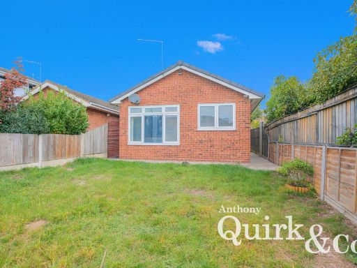 2 bedroom detached bungalow for sale in Tantelen Avenue, Canvey Island, SS8 — £325,000 • 2 bed • 1 bath • 772 ft²
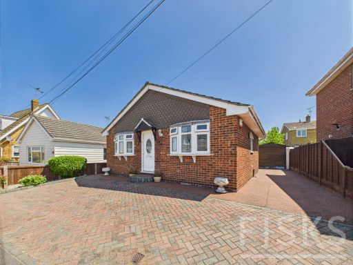 2 bedroom detached bungalow for sale in Hannett Road, Canvey Island, SS8 — £315,000 • 2 bed • 1 bath • 644 ft²
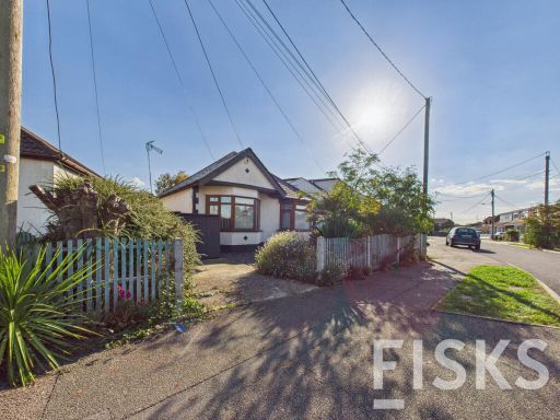 2 bedroom bungalow for sale in The Driveway, Canvey Island, SS8 — £350,000 • 2 bed • 1 bath • 679 ft²
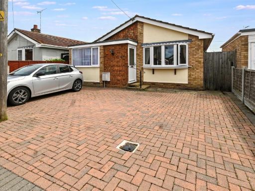 2 bedroom detached bungalow for sale in Hannett Road, Canvey Island, SS8 — £255,000 • 2 bed • 1 bath • 613 ft²
Meta
- {
"@context": "https://schema.org",
"@type": "Residence",
"name": "2 bedroom detached bungalow for sale in Crescent Road, Canv…",
"description": "",
"url": "https://propertypiper.co.uk/property/9c612fc5-dfed-49a3-9eb5-94354e952770",
"image": "https://image-a.propertypiper.co.uk/fec09c51-e212-4a07-acd1-5178d7e97f88-1024.jpeg",
"address": {
"@type": "PostalAddress",
"streetAddress": "9 CRESCENT ROAD CANVEY ISLAND",
"postalCode": "SS8 7JY",
"addressLocality": "Castle Point",
"addressRegion": "Castle Point",
"addressCountry": "England"
},
"geo": {
"@type": "GeoCoordinates",
"latitude": 51.517326975720756,
"longitude": 0.6043864486099387
},
"numberOfRooms": 2,
"numberOfBathroomsTotal": 1,
"floorSize": {
"@type": "QuantitativeValue",
"value": 922,
"unitCode": "FTK"
},
"offers": {
"@type": "Offer",
"price": 350000,
"priceCurrency": "GBP",
"availability": "https://schema.org/InStock"
},
"additionalProperty": [
{
"@type": "PropertyValue",
"name": "Feature",
"value": "bungalow"
},
{
"@type": "PropertyValue",
"name": "Feature",
"value": "mid-20th century"
},
{
"@type": "PropertyValue",
"name": "Feature",
"value": "detached"
},
{
"@type": "PropertyValue",
"name": "Feature",
"value": "garage"
},
{
"@type": "PropertyValue",
"name": "Feature",
"value": "garden"
},
{
"@type": "PropertyValue",
"name": "Feature",
"value": "off-street parking"
},
{
"@type": "PropertyValue",
"name": "Feature",
"value": "driveway"
},
{
"@type": "PropertyValue",
"name": "Feature",
"value": "gable roof"
},
{
"@type": "PropertyValue",
"name": "Feature",
"value": "fenced yard"
},
{
"@type": "PropertyValue",
"name": "Feature",
"value": "modern style"
},
{
"@type": "PropertyValue",
"name": "Feature",
"value": "corner fireplace"
},
{
"@type": "PropertyValue",
"name": "Feature",
"value": "bay window"
},
{
"@type": "PropertyValue",
"name": "Feature",
"value": "standard ceiling"
},
{
"@type": "PropertyValue",
"name": "Feature",
"value": "beige walls"
},
{
"@type": "PropertyValue",
"name": "Feature",
"value": "natural light"
}
]
}
High Res Floorplan Images
Compatible Floorplan Images
FloorplanImages Thumbnail