S61 4QF - 2 bedroom semidetached house for sale in Wagon Road, Rother…
View on Property Piper
2 bedroom semi-detached house for sale in Wagon Road, Rotherham, South Yorkshire, S61
Property Details
- Price: £110000
- Bedrooms: 2
- Bathrooms: 1
- Property Type: undefined
- Property SubType: undefined
Brochure Descriptions
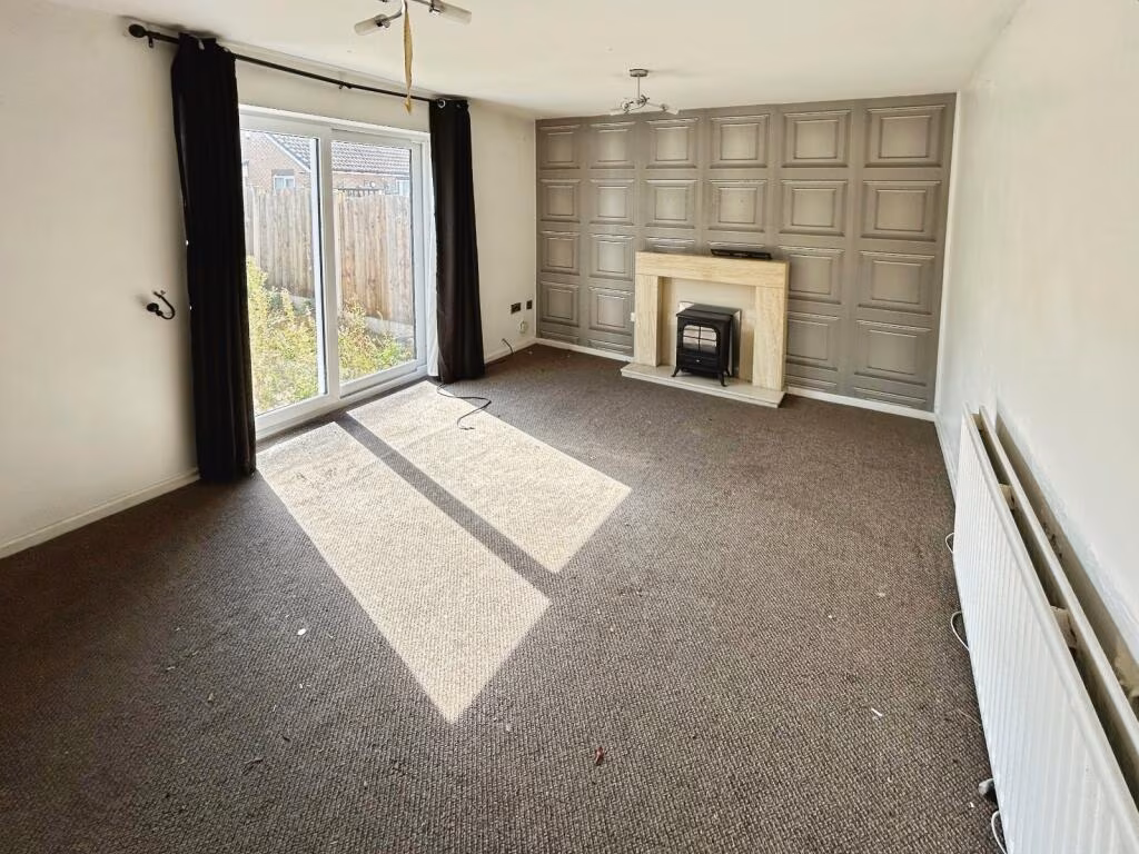
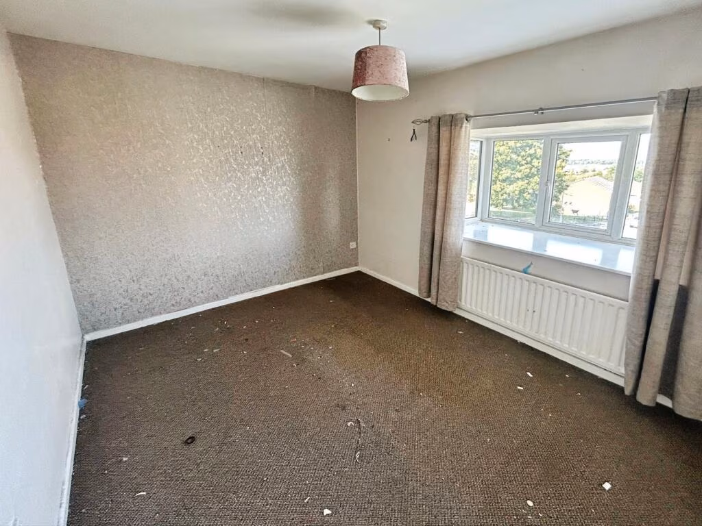
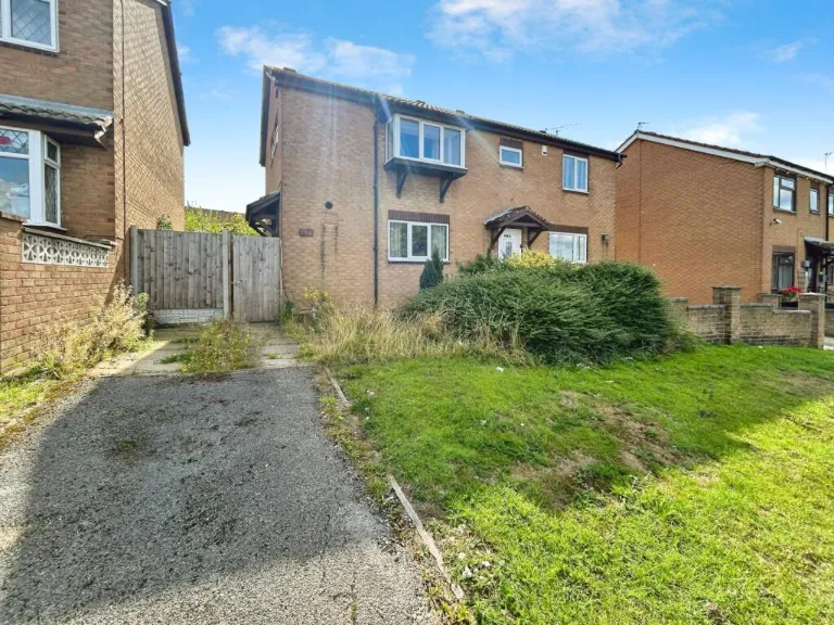
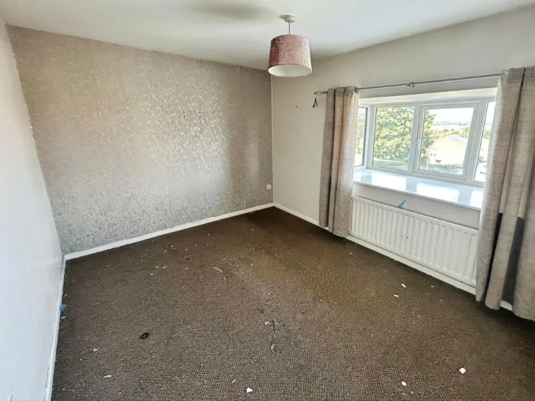
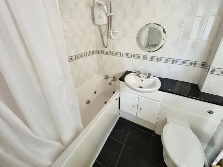
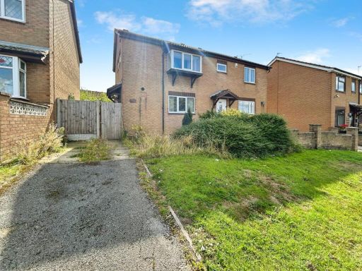
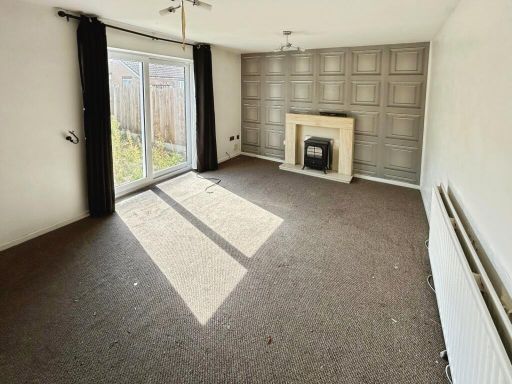
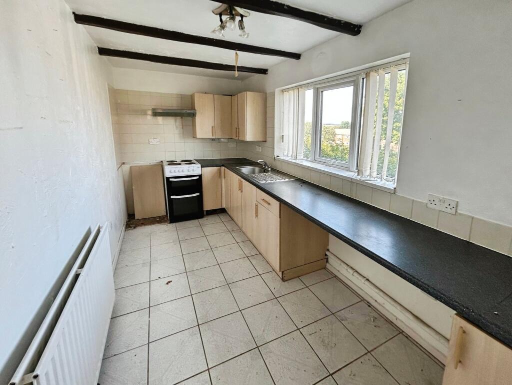
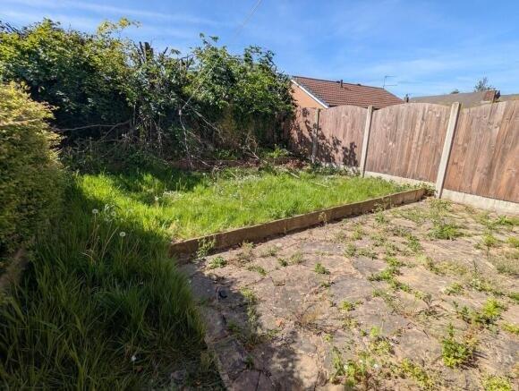
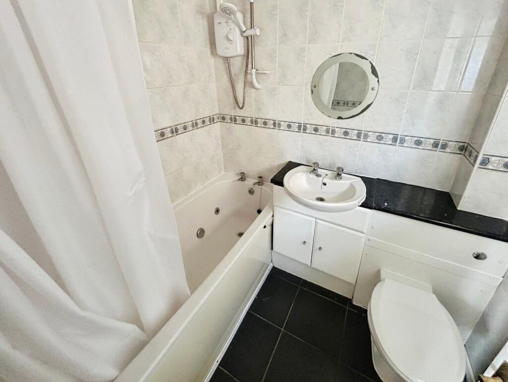
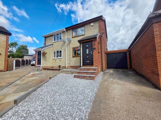
- Mid/End-terrace residential dwelling shown in multiple images. Property appears to be a small-to-average two-storey house with a driveway to the front and a modest rear garden. Accommodation visible: lounge with fireplace, separate kitchen, family bathroom with white suite, and upstairs bedrooms (two bedrooms shown). Externally: small front lawn and single-car driveway, enclosed rear garden with paved patio and a small lawn — garden size small. Overall condition: requires cosmetic refurbishment and updating (worn carpets, dated kitchen/bathroom finishes, general redecoration). Suitable for first-time buyers or investors as a refurbishment project. No exceptional views visible (residential neighbourhood setting).
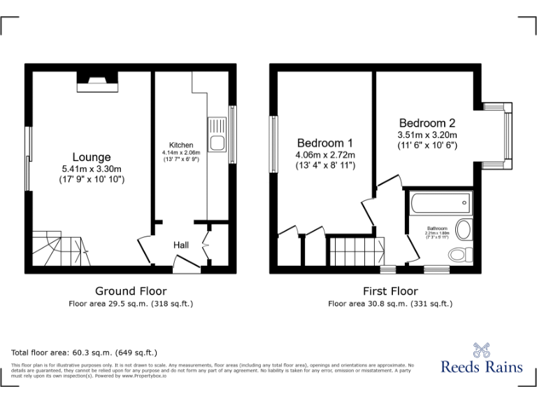
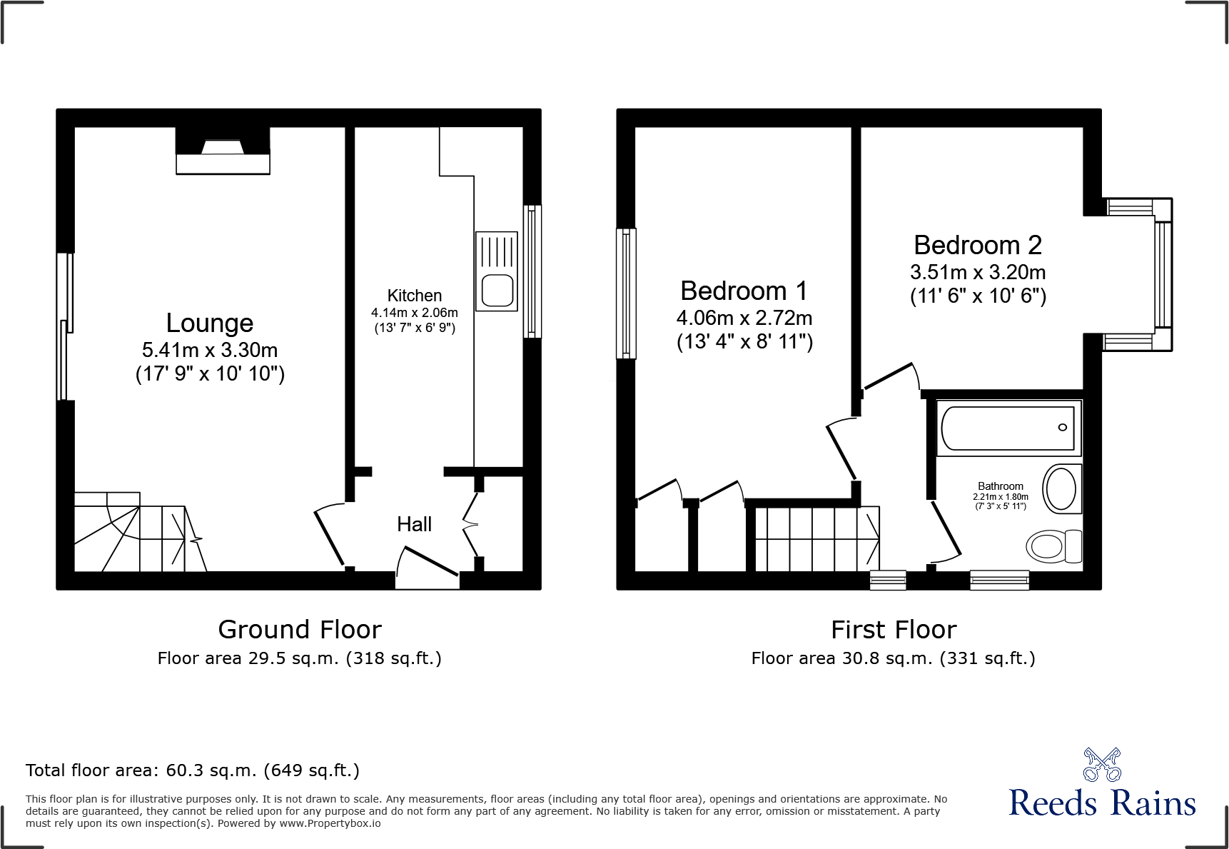
- Two-bedroom semi-detached house presented as a straightforward entry-level home. The property comprises an entrance hall, lounge, kitchen, first-floor landing, two bedrooms and a family bathroom. Externally there is off-road parking to the front, a lawned front area, and a rear patio with gated access to the front. Overall accommodation footprint is modest — suitable for first-time buyers or investors. Garden space is small to average (low-maintenance lawn and patio). Condition and fixtures appear standard for the market; potential for minor cosmetic improvement to increase value. Good commuter links and local amenities cited. Overall property size: small/average; usable internal area indicated on the floorplan as approximately 60.3 sq.m (649 sq.ft).
Image Descriptions
- exterior modern
- living room contemporary
Floorplan Description
- Floor plan showing Lounge, Kitchen, Hall, Bedroom 1, Bedroom 2 and Bathroom.
Rooms
- Lounge:
- Kitchen:
- Hall:
- Bedroom 1:
- Bedroom 2:
- Bathroom:
Textual Property Features
Detected Visual Features
- modern
- semi-detached
- garden
- garage
- driveway
- brickwork
- unkempt
- needs maintanence
- contemporary
- living room
- medium size
- standard ceiling
- modern fireplace
- wood paneling
- sliding glass door
- garden access
- natural light
EPC Details
- Fully double glazed
- Cavity wall, as built, partial insulation (assumed)
- Boiler and radiators, mains gas
- Low energy lighting in all fixed outlets
- Suspended, no insulation (assumed)
Nearby Schools
- Canklow Woods Primary School
- Broom Valley Community School
- Ferham Primary School
- Thornhill Primary School
- East Dene Primary
- Coleridge Primary
- Rockingham Junior and Infant School
- Rawmarsh Thorogate Junior and Infant School
- Tinsley Meadows Primary School
- Oakwood High School
- Kimberworth Community Primary School
- Redscope Primary School
- Wingfield Academy
- St Joseph's Catholic Primary School
- Monkwood Primary School
- Meadow View Primary School
- Clifton Community School
- St Ann's Primary School
- Rawmarsh Ashwood Primary School
- Rawmarsh Community School
- Rawmarsh Rosehill Junior School
- Brinsworth Manor Junior School
- Winterhill School
- St Bede's Catholic Primary School
- Eastwood Village Primary School
- Roughwood Primary School
- Greasbrough Primary School
Nearest Bars And Restaurants
- Id: 469775742
- Tags:
- Amenity: pub
- Name: The Pewter Pot
- Source: photo
- TagsNormalized:
- Lat: 53.4401944
- Lon: -1.3923451
- FullGeoHash: gcx0026psn20
- PartitionGeoHash: gcx0
- Images:
- FoodStandards: null
- Distance: 1562.9
,- Id: 701083959
- Tags:
- Addr:
- City: Rotherham
- Postcode: S61 4RJ
- Street: Mangham Road
- Amenity: cafe
- Building: yes
- Cuisine: burger;sandwich
- Name: Barbot Sandwiches
- TagsNormalized:
- Lat: 53.4432107
- Lon: -1.3573381
- FullGeoHash: gcx0115978x3
- PartitionGeoHash: gcx0
- Images:
- FoodStandards: null
- Distance: 1250.5
,- Id: 2079282759
- Tags:
- Amenity: pub
- Name: The Plough
- TagsNormalized:
- Lat: 53.4510573
- Lon: -1.3894485
- FullGeoHash: gcx006knzx20
- PartitionGeoHash: gcx0
- Images:
- FoodStandards: null
- Distance: 1071.8
,- Id: 433084260
- Tags:
- Amenity: pub
- Building: yes
- Name: The Ring O' Bells
- TagsNormalized:
- Lat: 53.4428018
- Lon: -1.3825949
- FullGeoHash: gcx008cnzhqd
- PartitionGeoHash: gcx0
- Images:
- FoodStandards: null
- Distance: 890.9
,- Id: 469775622
- Tags:
- Amenity: pub
- Name: The Keppels
- Source: photo
- TagsNormalized:
- Lat: 53.4499429
- Lon: -1.3820068
- FullGeoHash: gcx00d38kzt0
- PartitionGeoHash: gcx0
- Images:
- FoodStandards: null
- Distance: 563.7
}
Nearest General Shops
- Id: 227506275
- Tags:
- Brand: Screwfix
- Brand:wikidata: Q7439115
- Building: industrial
- Name: Screwfix
- Shop: doityourself
- Source: Bing;survey
- TagsNormalized:
- screwfix
- industrial
- doityourself
- shop
- Lat: 53.4441614
- Lon: -1.3559777
- FullGeoHash: gcx011hwg3v8
- PartitionGeoHash: gcx0
- Images:
- FoodStandards: null
- Distance: 1283.2
,- Id: 301913994
- Tags:
- Name: Clough Nurseries
- Shop: garden_centre
- TagsNormalized:
- nurseries
- garden centre
- shop
- Lat: 53.4377528
- Lon: -1.3703265
- FullGeoHash: gcx00b41mp4s
- PartitionGeoHash: gcx0
- Images:
- FoodStandards: null
- Distance: 1250.4
,- Id: 939044886
- Tags:
- Addr:
- City: Greasbrough
- Housenumber: 29
- Postcode: S61 4PX
- Street: Main Street
- Building: yes
- Shop: hairdresser
- TagsNormalized:
- Lat: 53.4549669
- Lon: -1.3688176
- FullGeoHash: gcx00g5mb0pd
- PartitionGeoHash: gcx0
- Images:
- FoodStandards: null
- Distance: 756.7
}
Nearest Supermarkets
- Id: 158344593
- Tags:
- Addr:
- City: Rotherham
- Postcode: S62 6EE
- Street: Taylors Lane
- Brand: Asda
- Brand:wikidata: Q297410
- Building: yes
- Name: Asda
- Shop: supermarket
- TagsNormalized:
- Lat: 53.4505796
- Lon: -1.345386
- FullGeoHash: gcx016kk4npq
- PartitionGeoHash: gcx0
- Images:
- FoodStandards: null
- Distance: 1885.7
,- Id: 226960722
- Tags:
- Brand: ALDI
- Brand:wikidata: Q41171672
- Brand:wikipedia: en:Aldi
- Building: commercial
- Contact:
- Website: https://stores.aldi.co.uk/masbrough/park-street
- Name: Aldi
- Shop: supermarket
- Source: Bing
- TagsNormalized:
- Lat: 53.4333422
- Lon: -1.3732772
- FullGeoHash: gcrpbz0pb2fm
- PartitionGeoHash: gcrp
- Images:
- FoodStandards: null
- Distance: 1720.8
,- Id: 1705929109
- Tags:
- Name: Co-op
- Shop: supermarket
- TagsNormalized:
- Lat: 53.4533185
- Lon: -1.3737294
- FullGeoHash: gcx00dzsjuc1
- PartitionGeoHash: gcx0
- Images:
- FoodStandards: null
- Distance: 500.7
}
Nearest Religious buildings
- Id: 227478479
- Tags:
- Amenity: place_of_worship
- Building: yes
- Denomination: jehovahs_witness
- Name: Kingdom Hall of Jehovah's Witnesses
- Religion: christian
- Source: Bing;survey
- TagsNormalized:
- place of worship
- jehovah
- jehovahs witness
- christian
- church
- Lat: 53.433559
- Lon: -1.3627831
- FullGeoHash: gcrpbzr9hc77
- PartitionGeoHash: gcrp
- Images:
- FoodStandards: null
- Distance: 1844.4
,- Id: 653815382
- Tags:
- Amenity: place_of_worship
- Building: yes
- Denomination: anglican
- Name: St Johns Church
- Religion: christian
- Wikidata: Q105103290
- TagsNormalized:
- place of worship
- anglican
- church
- christian
- Lat: 53.4429549
- Lon: -1.3927509
- FullGeoHash: gcx002czf8ce
- PartitionGeoHash: gcx0
- Images:
- FoodStandards: null
- Distance: 1419.6
,- Id: 835002898
- Tags:
- Amenity: place_of_worship
- Building: church
- Denomination: anglican
- Name: St Mary
- Religion: christian
- Wikidata: Q26486635
- TagsNormalized:
- place of worship
- church
- anglican
- christian
- Lat: 53.4561854
- Lon: -1.3717783
- FullGeoHash: gcx00g3hg5py
- PartitionGeoHash: gcx0
- Images:
- FoodStandards: null
- Distance: 829.3
}
Nearest Medical buildings
- Id: 63825205
- Tags:
- Amenity: doctors
- Building: yes
- Name: Rotherham Community Health Centre
- Source: Bing;survey
- TagsNormalized:
- doctor
- doctors
- health
- health centre
- Lat: 53.4348442
- Lon: -1.3585335
- FullGeoHash: gcrpcpd8xbuj
- PartitionGeoHash: gcrp
- Images:
- FoodStandards: null
- Distance: 1850.3
,- Id: 469775933
- Tags:
- Amenity: pharmacy
- Brand: Lloyds Pharmacy
- Brand:wikidata: Q6662870
- Healthcare: pharmacy
- Name: Lloyds Pharmacy
- TagsNormalized:
- pharmacy
- lloyds pharmacy
- health
- healthcare
- Lat: 53.4404925
- Lon: -1.3943525
- FullGeoHash: gcx00289mjz6
- PartitionGeoHash: gcx0
- Images:
- FoodStandards: null
- Distance: 1651.1
,- Id: 469775919
- Tags:
- Amenity: doctors
- Healthcare: doctor
- Name: Kimberworth Park Medical Centre
- TagsNormalized:
- doctor
- doctors
- health
- healthcare
- Lat: 53.4404414
- Lon: -1.3941722
- FullGeoHash: gcx0028c1kmf
- PartitionGeoHash: gcx0
- Images:
- FoodStandards: null
- Distance: 1644.4
,- Id: 1705929093
- Tags:
- Amenity: pharmacy
- Name: Lloyds
- TagsNormalized:
- Lat: 53.4534958
- Lon: -1.3732841
- FullGeoHash: gcx00fbj0jv4
- PartitionGeoHash: gcx0
- Images:
- FoodStandards: null
- Distance: 521.1
}
Nearest Airports
- Id: 100889514
- Tags:
- Addr:
- Aerodrome: international
- Aerodrome:type: public
- Area: yes
- Cities_served: Doncaster, Sheffield
- Closest_town: Doncaster
- Disused:
- Ele: 17
- Iata: DSA
- Icao: EGCN
- Ifr: yes
- Is_in: Finningley
- Name: Doncaster Sheffield Airport
- Old_iata: FNY
- Old_icao: EGXI
- Old_name: RAF Finningley
- Old_operator: Royal Air Force
- Old_type: military
- Operator: Doncaster Sheffield Airport Limited/Peel Airports
- Source: wikipedia
- Tower_frequency: 128.775
- Vfr: yes
- Website: https://www.robinhoodairport.com/
- Wikidata: Q8996
- Wikipedia: en:Robin Hood Airport Doncaster Sheffield
- TagsNormalized:
- airport
- international airport
- Lat: 53.4761577
- Lon: -1.0054086
- FullGeoHash: gcx21p5chq34
- PartitionGeoHash: gcx2
- Images:
- FoodStandards: null
- Distance: 24570.1
}
Nearest Leisure Facilities
- Id: 301906176
- Tags:
- Foot: yes
- Leisure: park
- Opening_hours: 24/7
- TagsNormalized:
- Lat: 53.4546879
- Lon: -1.3758058
- FullGeoHash: gcx00enhjkhc
- PartitionGeoHash: gcx0
- Images:
- FoodStandards: null
- Distance: 667.5
,- Id: 158338343
- Tags:
- TagsNormalized:
- Lat: 53.4473502
- Lon: -1.3824728
- FullGeoHash: gcx009c36h1w
- PartitionGeoHash: gcx0
- Images:
- FoodStandards: null
- Distance: 602.9
,- Id: 158338339
- Tags:
- TagsNormalized:
- Lat: 53.4479071
- Lon: -1.3823076
- FullGeoHash: gcx009cktuh8
- PartitionGeoHash: gcx0
- Images:
- FoodStandards: null
- Distance: 578.4
,- Id: 301906179
- Tags:
- TagsNormalized:
- Lat: 53.4505334
- Lon: -1.3781774
- FullGeoHash: gcx00dk7yjs7
- PartitionGeoHash: gcx0
- Images:
- FoodStandards: null
- Distance: 352.3
,- Id: 301906178
- Tags:
- TagsNormalized:
- Lat: 53.4505289
- Lon: -1.3764211
- FullGeoHash: gcx00dmezhf0
- PartitionGeoHash: gcx0
- Images:
- FoodStandards: null
- Distance: 261.9
}
Nearest Tourist attractions
- Id: 667548574
- Tags:
- Name: Fun Park
- Tourism: theme_park
- TagsNormalized:
- Lat: 53.4325116
- Lon: -1.3445988
- FullGeoHash: gcrpcrhfuw47
- PartitionGeoHash: gcrp
- Images:
- FoodStandards: null
- Distance: 2646.5
,- Id: 796898324
- Tags:
- Building: yes
- Layer: 1
- Museum: transport
- Name: South Yorkshire Transport Trust
- Tourism: museum
- TagsNormalized:
- Lat: 53.4417835
- Lon: -1.3391566
- FullGeoHash: gcx018bbgqs2
- PartitionGeoHash: gcx0
- Images:
- FoodStandards: null
- Distance: 2418.1
,- Id: 231218420
- Tags:
- Addr:
- City: Rotherham
- Housename: Unit 9
- Postcode: S65 3SH
- Street: Waddington Way
- Building: industrial
- Name: South Yorkshire Transport Museum
- Phone: +44 782 806 8484
- Source: Bing;survey
- Tourism: museum
- Website: https://www.sytm.co.uk/
- Wikidata: Q7569008
- Wikipedia: en:South Yorkshire Transport Museum
- TagsNormalized:
- Lat: 53.4451772
- Lon: -1.3377762
- FullGeoHash: gcx0193uex1u
- PartitionGeoHash: gcx0
- Images:
- FoodStandards: null
- Distance: 2413.7
}
Nearest Train stations
- Id: 3198828652
- Tags:
- Name: Mexborough
- Naptan:
- Network: National Rail
- Operator: Northern Rail
- Public_transport: station
- Railway: station
- Ref:
- Source: wikipedia
- Upload_tag: ojw_newcastle
- Wikidata: Q3983146
- Wikipedia: en:Mexborough railway station
- TagsNormalized:
- Lat: 53.4908309
- Lon: -1.2885249
- FullGeoHash: gcx069twxjw5
- PartitionGeoHash: gcx0
- Images:
- FoodStandards: null
- Distance: 7322.2
,- Id: 3204141646
- Tags:
- Name: Swinton (South Yorkshire)
- Naptan:
- Network: National Rail
- Operator: Northern Rail
- Public_transport: station
- Railway: station
- Ref:
- Source: Wikipedia
- Wikidata: Q2253025
- Wikipedia: en:Swinton railway station (South Yorkshire)
- TagsNormalized:
- Lat: 53.4855977
- Lon: -1.3056214
- FullGeoHash: gcx062c20y41
- PartitionGeoHash: gcx0
- Images:
- FoodStandards: null
- Distance: 6085.9
,- Id: 1477345762
- Tags:
- Heritage: 2
- Heritage:operator: Elsecar Heritage Railway Ltd
- Name: Rockingham
- Public_transport: station
- Railway: station
- Usage: tourism
- Wikidata: Q7355379
- Wikipedia: en:Rockingham railway station (South Yorkshire)
- TagsNormalized:
- Lat: 53.4937958
- Lon: -1.4192072
- FullGeoHash: gcwbrdnxfn63
- PartitionGeoHash: gcwb
- Images:
- FoodStandards: null
- Distance: 5838.2
,- Id: 7149987542
- Tags:
- Name: Meadowhall Interchange
- Naptan:
- Network: National Rail
- Operator: Northern Rail
- Public_transport: station
- Railway: station
- Ref:
- Wikidata: Q2467647
- Wikipedia: en:Meadowhall Interchange
- TagsNormalized:
- Lat: 53.4168529
- Lon: -1.4138361
- FullGeoHash: gcqzzu4rxpp7
- PartitionGeoHash: gcqz
- Images:
- FoodStandards: null
- Distance: 4438.3
,- Id: 3204155746
- Tags:
- Name: Rotherham Central
- Naptan:
- Network: National Rail
- Operator: Northern Rail
- Public_transport: station
- Railway: station
- Ref:
- Source: Wikipedia
- Wikidata: Q2025773
- Wikipedia: en:Rotherham Central station
- TagsNormalized:
- Lat: 53.4316986
- Lon: -1.3610462
- FullGeoHash: gcrpcnbyjqd3
- PartitionGeoHash: gcrp
- Images:
- FoodStandards: null
- Distance: 2079.9
}
Nearest Hotels
- Id: 386030101
- Tags:
- Addr:
- City: Rotherham
- Housenumber: 9
- Postcode: S60 1HX
- Street: Princes Street
- Amenity: pub
- Building: yes
- Name: Prince of Wales Hotel
- TagsNormalized:
- Lat: 53.4302278
- Lon: -1.371045
- FullGeoHash: gcrpby9tsk6g
- PartitionGeoHash: gcrp
- Images:
- FoodStandards: null
- Distance: 2074.4
,- Id: 228704724
- Tags:
- Addr:
- City: Rotherham
- Postcode: S62 6EE
- Street: Taylors Lane
- Building: yes
- Fax: +44 1709 529641
- Name: Fitzwilliams Arms Hotel
- Phone: +44 1709 522744
- Rooms: 40
- Source: Bing;survey
- Tourism: hotel
- Website: http://www.fitzwilliamarmshotel.co.uk/
- TagsNormalized:
- Lat: 53.4501513
- Lon: -1.3471367
- FullGeoHash: gcx016719qq5
- PartitionGeoHash: gcx0
- Images:
- FoodStandards: null
- Distance: 1765.8
,- Id: 429758557
- Tags:
- Building: yes
- Tourism: hotel
- TagsNormalized:
- Lat: 53.4379203
- Lon: -1.3916659
- FullGeoHash: gcx0024d7y6e
- PartitionGeoHash: gcx0
- Images:
- FoodStandards: null
- Distance: 1697.8
}
Tags
- modern
- semi-detached
- garden
- garage
- driveway
- brickwork
- unkempt
- needs maintanence
- contemporary
- living room
- medium size
- standard ceiling
- modern fireplace
- wood paneling
- sliding glass door
- garden access
- natural light
Local Market Stats
- Average Price/sqft: £164
- Avg Income: £32800
- Rental Yield: 4.9%
- Social Housing: 20%
- Planning Success Rate: 92%
AirBnB Data
- 1km average: £76/night
- Listings in 1km: 1
Similar Properties
 2 bedroom semi-detached house for sale in Burnsall Grove, Barnsley, S70 3JR, S70 — £167,000 • 2 bed • 1 bath • 482 ft²
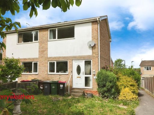 2 bedroom semi-detached house for sale in Sunnybank Crescent, Brinsworth, Rotherham, S60 — £130,000 • 2 bed • 1 bath • 485 ft²
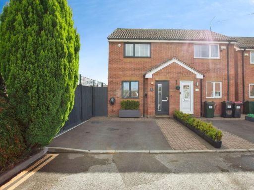 2 bedroom semi-detached house for sale in Katherine Court, Rotherham, S66 — £125,000 • 2 bed • 1 bath • 631 ft²
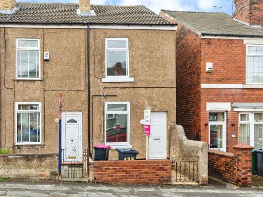 2 bedroom terraced house for sale in Claypit Lane, Rawmarsh, Rotherham, S62 — £110,000 • 2 bed • 1 bath • 603 ft²
 3 bedroom semi-detached house for sale in Barrie Grove, Hellaby, Rotherham, South Yorkshire, S66 — £230,000 • 3 bed • 1 bath • 965 ft²
 2 bedroom semi-detached house for sale in Margaret Road, Wombwell, Barnsley, S73 — £170,000 • 2 bed • 1 bath • 825 ft²
Meta
- {
"@context": "https://schema.org",
"@type": "Residence",
"name": "2 bedroom semidetached house for sale in Wagon Road, Rother…",
"description": "",
"url": "https://propertypiper.co.uk/property/9c55f7b3-b5c4-4f7b-b88b-da1e4167417e",
"image": "https://image-a.propertypiper.co.uk/65163344-3651-4b4c-a54c-5ec1b56d8a5f-1024.jpeg",
"address": {
"@type": "PostalAddress",
"streetAddress": "206 WAGON ROAD ROTHERHAM",
"postalCode": "S61 4QF",
"addressLocality": "Rotherham",
"addressRegion": "Rotherham",
"addressCountry": "England"
},
"geo": {
"@type": "GeoCoordinates",
"latitude": 53.44881604967324,
"longitude": -1.3737072774601853
},
"numberOfRooms": 2,
"numberOfBathroomsTotal": 1,
"floorSize": {
"@type": "QuantitativeValue",
"value": 649,
"unitCode": "FTK"
},
"offers": {
"@type": "Offer",
"price": 110000,
"priceCurrency": "GBP",
"availability": "https://schema.org/InStock"
},
"additionalProperty": [
{
"@type": "PropertyValue",
"name": "Feature",
"value": "modern"
},
{
"@type": "PropertyValue",
"name": "Feature",
"value": "semi-detached"
},
{
"@type": "PropertyValue",
"name": "Feature",
"value": "garden"
},
{
"@type": "PropertyValue",
"name": "Feature",
"value": "garage"
},
{
"@type": "PropertyValue",
"name": "Feature",
"value": "driveway"
},
{
"@type": "PropertyValue",
"name": "Feature",
"value": "brickwork"
},
{
"@type": "PropertyValue",
"name": "Feature",
"value": "unkempt"
},
{
"@type": "PropertyValue",
"name": "Feature",
"value": "needs maintanence"
},
{
"@type": "PropertyValue",
"name": "Feature",
"value": "contemporary"
},
{
"@type": "PropertyValue",
"name": "Feature",
"value": "living room"
},
{
"@type": "PropertyValue",
"name": "Feature",
"value": "medium size"
},
{
"@type": "PropertyValue",
"name": "Feature",
"value": "standard ceiling"
},
{
"@type": "PropertyValue",
"name": "Feature",
"value": "modern fireplace"
},
{
"@type": "PropertyValue",
"name": "Feature",
"value": "wood paneling"
},
{
"@type": "PropertyValue",
"name": "Feature",
"value": "sliding glass door"
},
{
"@type": "PropertyValue",
"name": "Feature",
"value": "garden access"
},
{
"@type": "PropertyValue",
"name": "Feature",
"value": "natural light"
}
]
}
High Res Floorplan Images
Compatible Floorplan Images
FloorplanImages Thumbnail