TS13 4RA - 3 bedroom terraced house for sale in Railway Terrace, Loftu…
View on Property Piper
3 bedroom terraced house for sale in Railway Terrace, Loftus, Saltburn-by-the-Sea, North Yorkshire, TS13
Property Details
- Price: £100000
- Bedrooms: 3
- Bathrooms: 1
- Property Type: undefined
- Property SubType: undefined
Brochure Descriptions
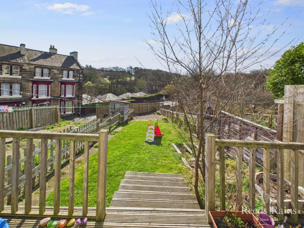
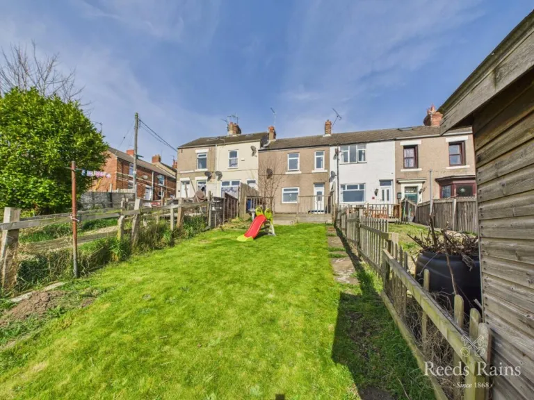
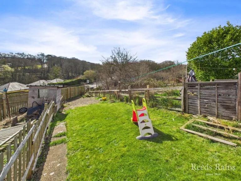
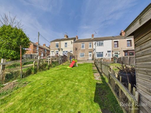
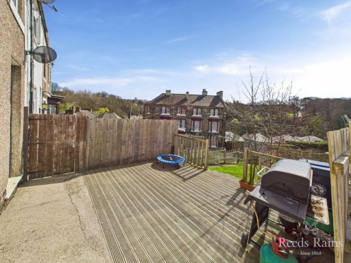
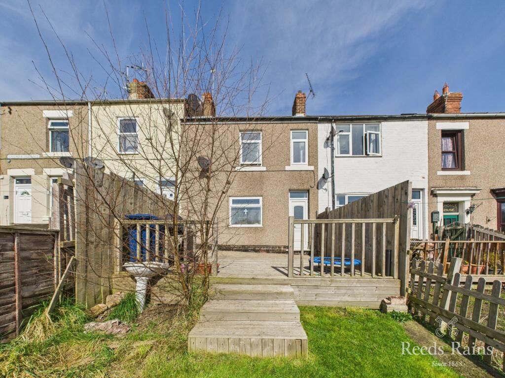
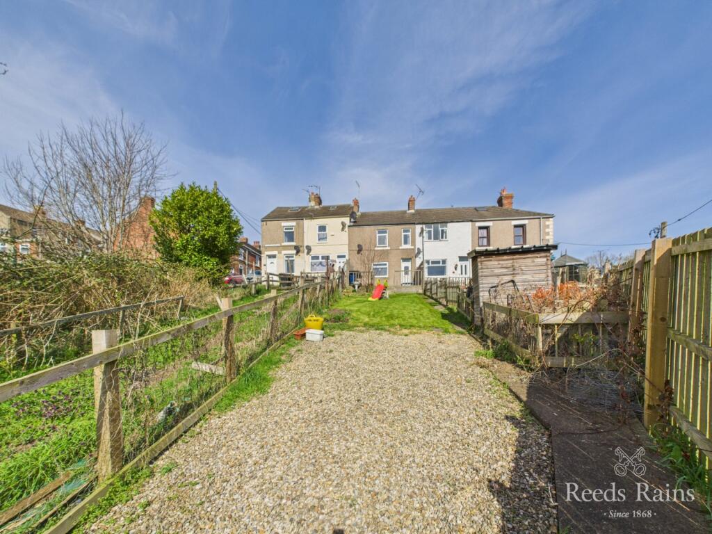
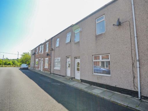
- Mid-terraced two-storey residential property situated on Railway Terrace in Loftus, Saltburn-by-the-Sea. The images show a traditional row of terraced houses with a long, enclosed rear garden of generous length (large rear garden for this property type) laid mainly to lawn with narrow paved side path and timber garden shed to the rear. The terrace appears to be stone/brick rendered construction with modest rear elevations and standard first-floor fenestration. The plot is typical of older terrace stock — relatively narrow frontage with an extended rear garden providing usable outdoor amenity space. Views are of neighbouring terraces and private gardens; no elevated or exceptional views (coast/river/woodland) are evident. Overall size appears consistent with a small-to-average family terraced house; garden provision is above average for the type and represents positive value for purchasers seeking outdoor space. Likely suitable for refurbishment or modest modernisation to increase market appeal.
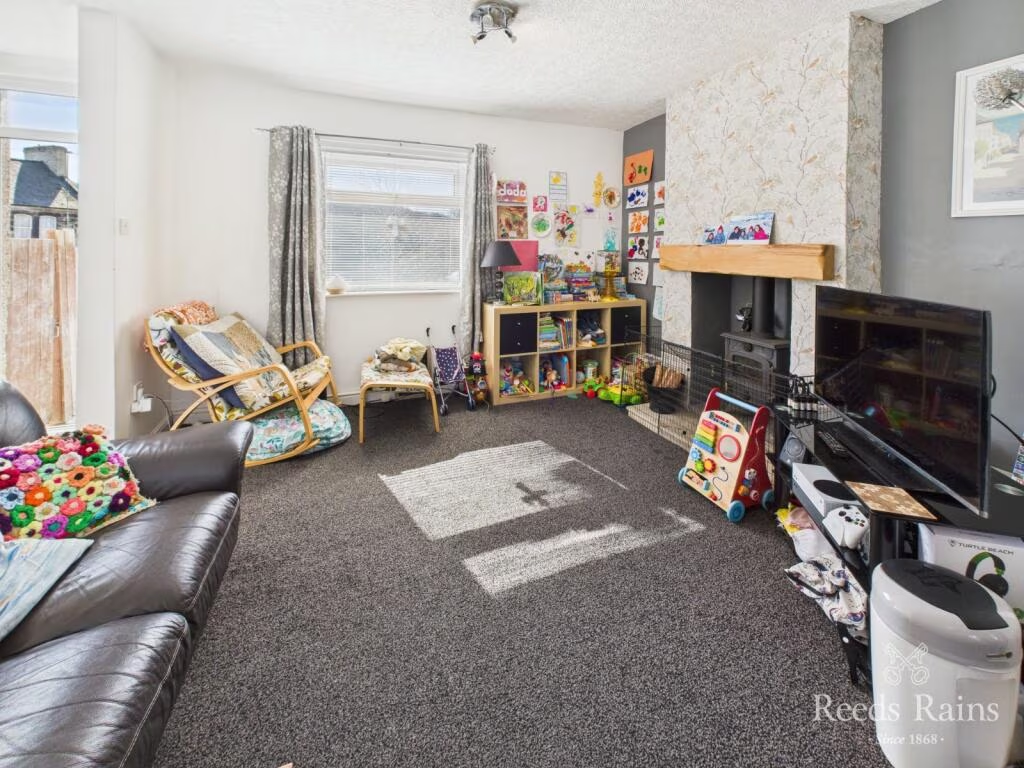
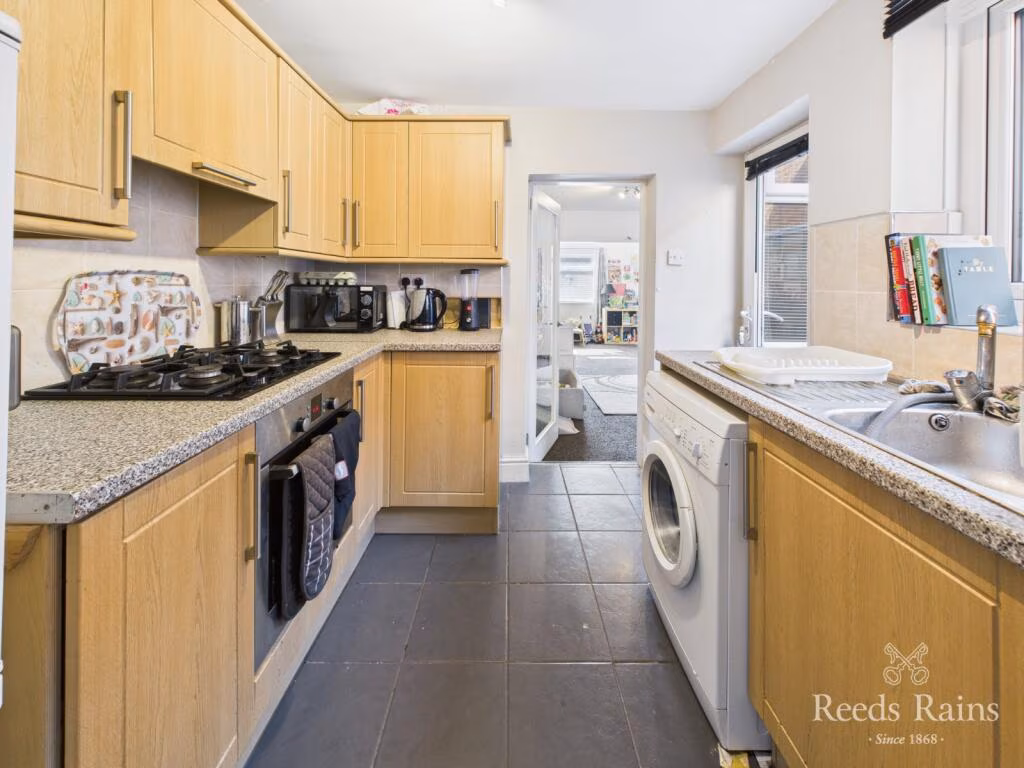
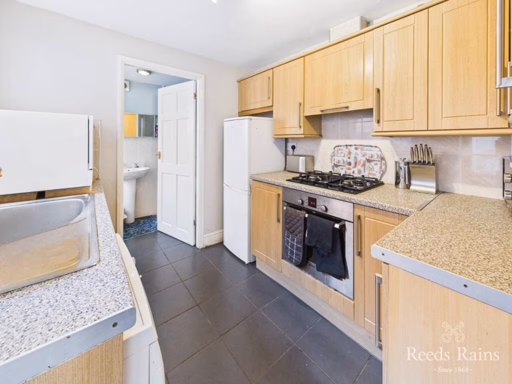
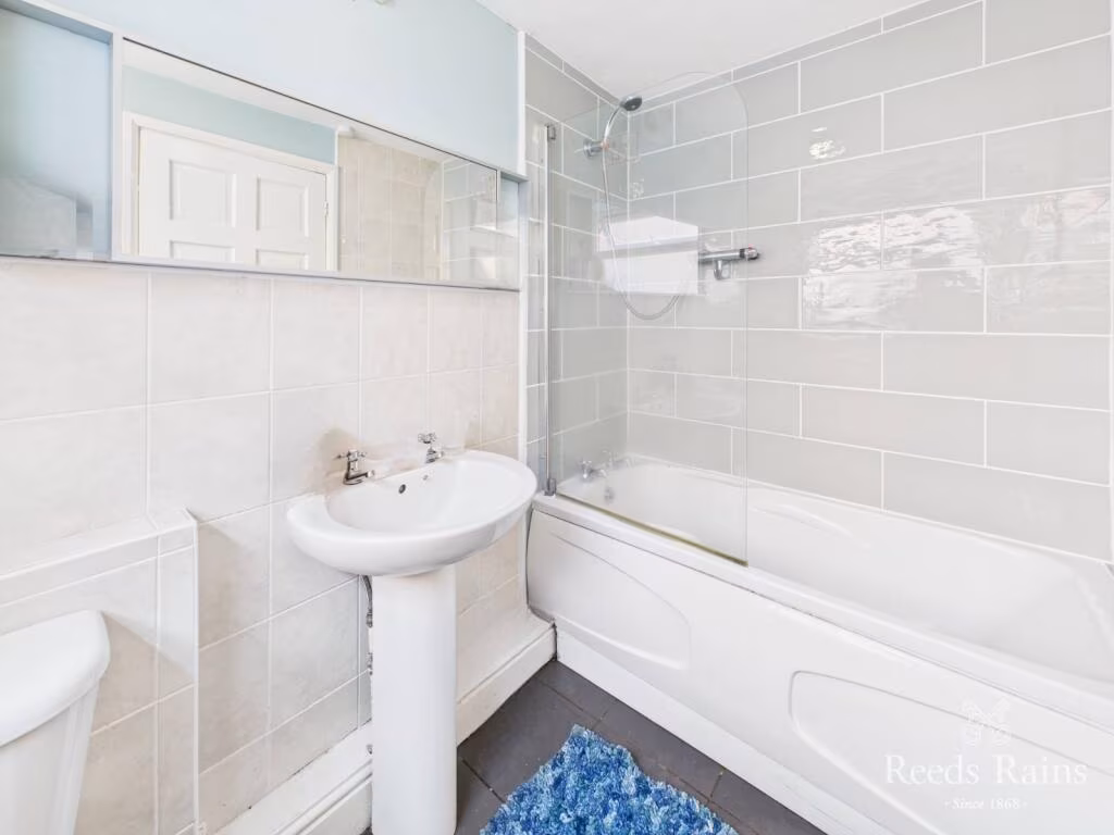
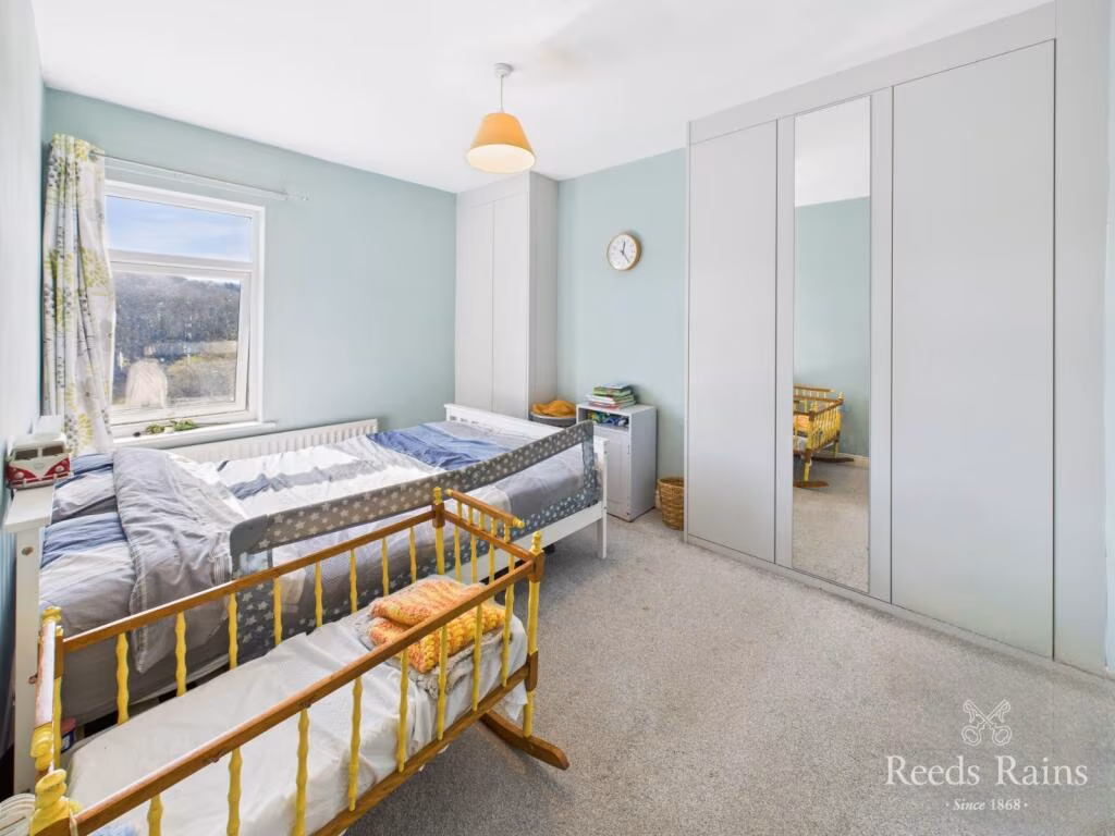
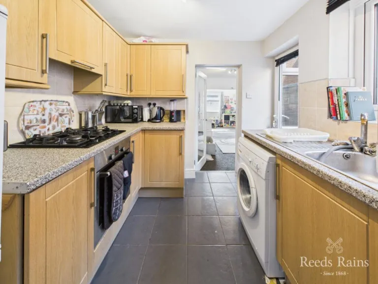
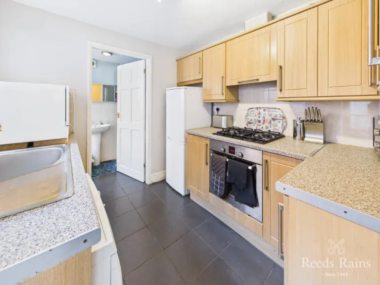
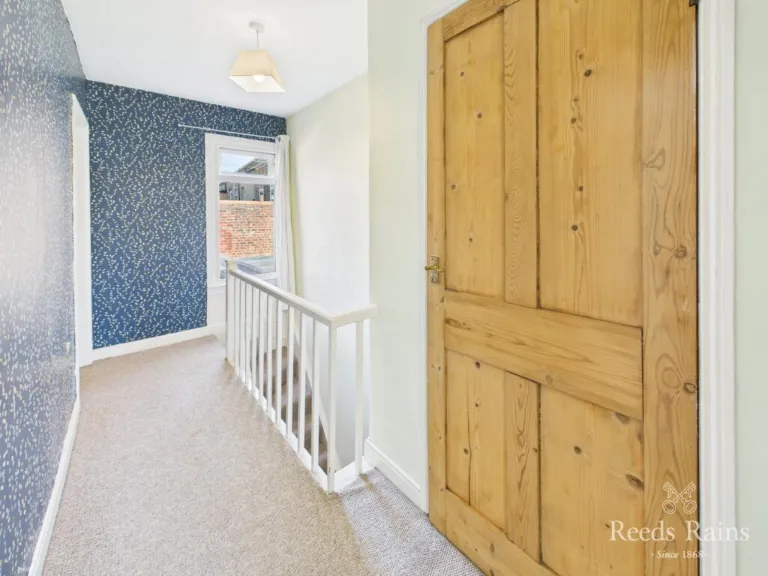
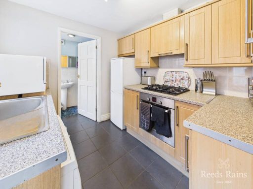
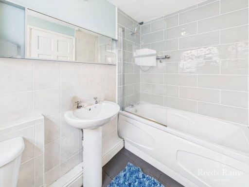
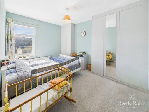
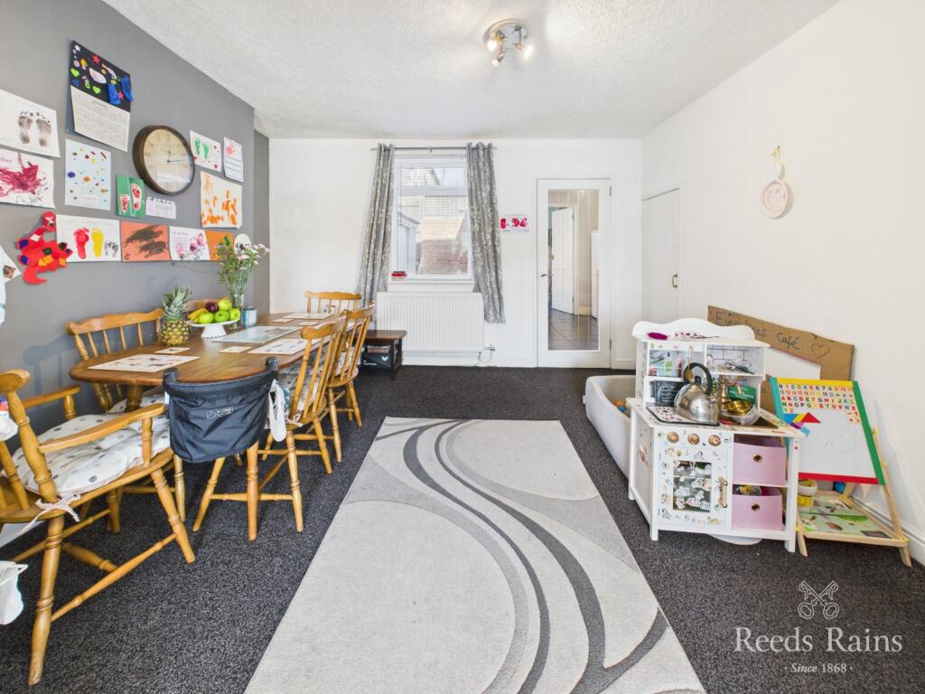
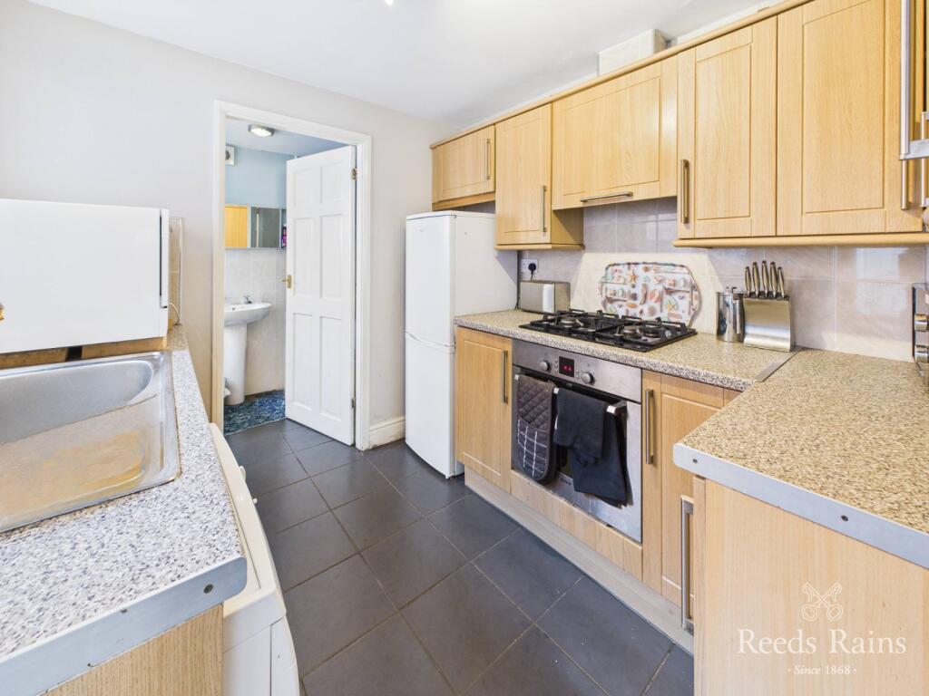
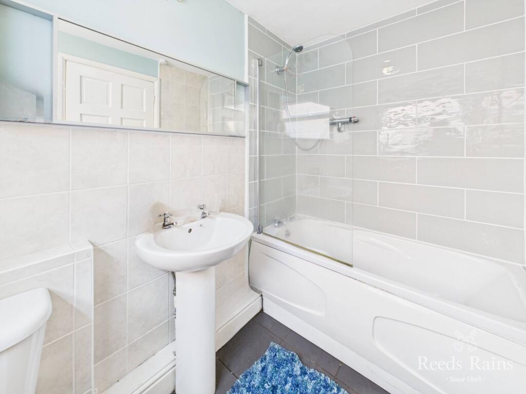
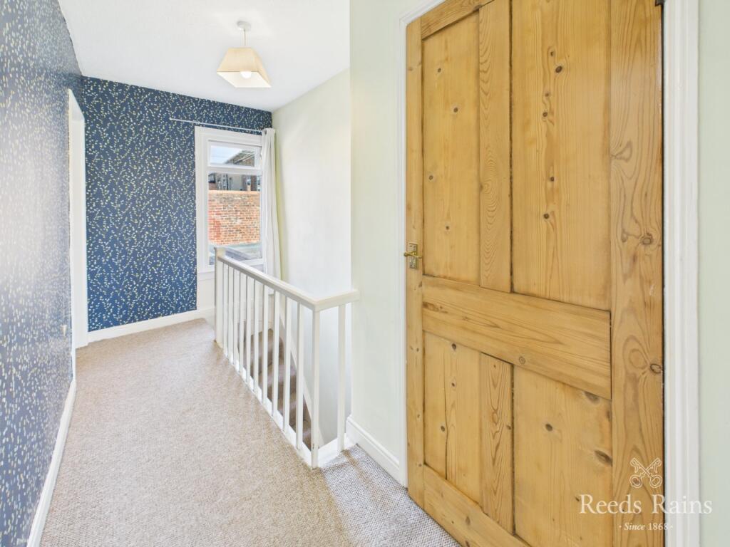
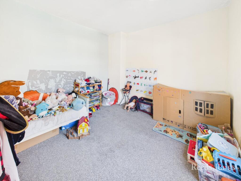
- Interior images show a modest, likely mid-terrace residential property with a narrow galley kitchen fitted with light wood units, laminate or composite worktops, integrated oven/hob and space for a washing machine. Flooring appears to be dark ceramic/porcelain tiles in the kitchen. A compact family bathroom is fitted with a bath and overhead shower, pedestal basin and tiled surround. A narrow first-floor landing with a wooden internal door is visible, suggesting small bedrooms typical of an older terraced house. No garden or external grounds are visible in these images. Overall impression: a small to average-sized terraced dwelling in tidy, functional condition suitable for a couple or small family, likely requiring only standard cosmetic updating rather than major works.
Image Descriptions
- rear of terraced houses with gardens Victorian
- garden
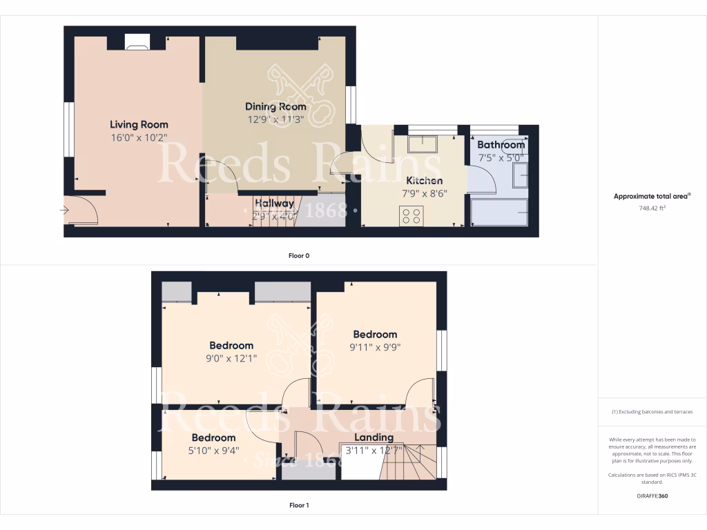
Floorplan Description
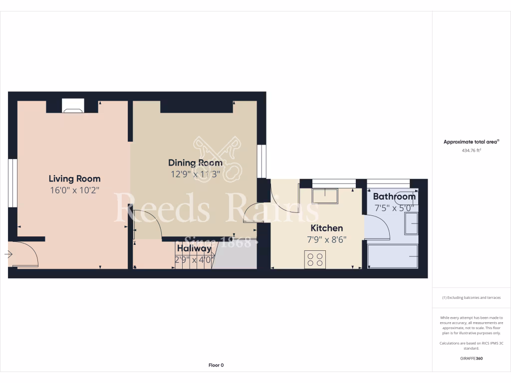
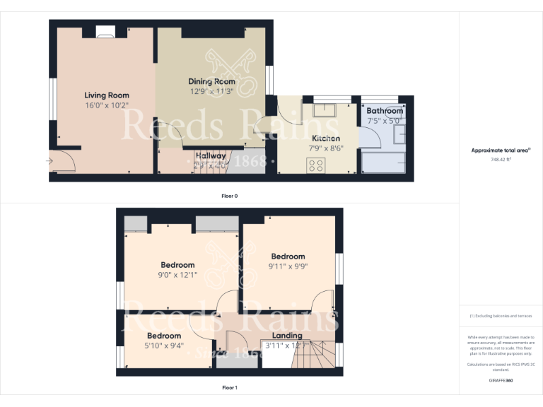
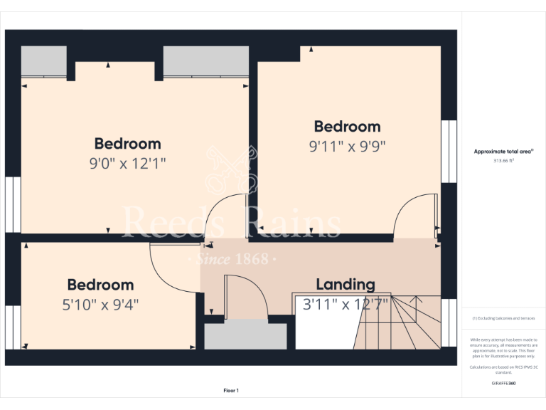
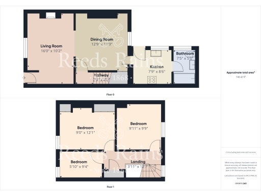
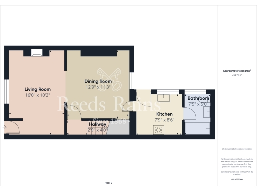
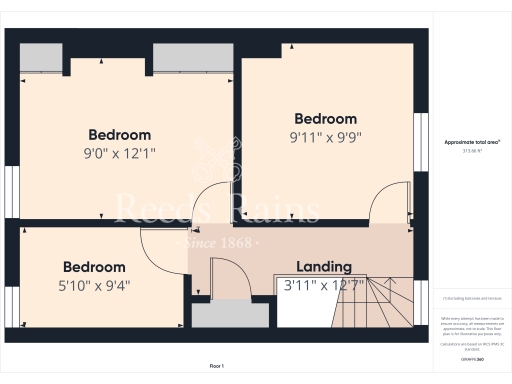
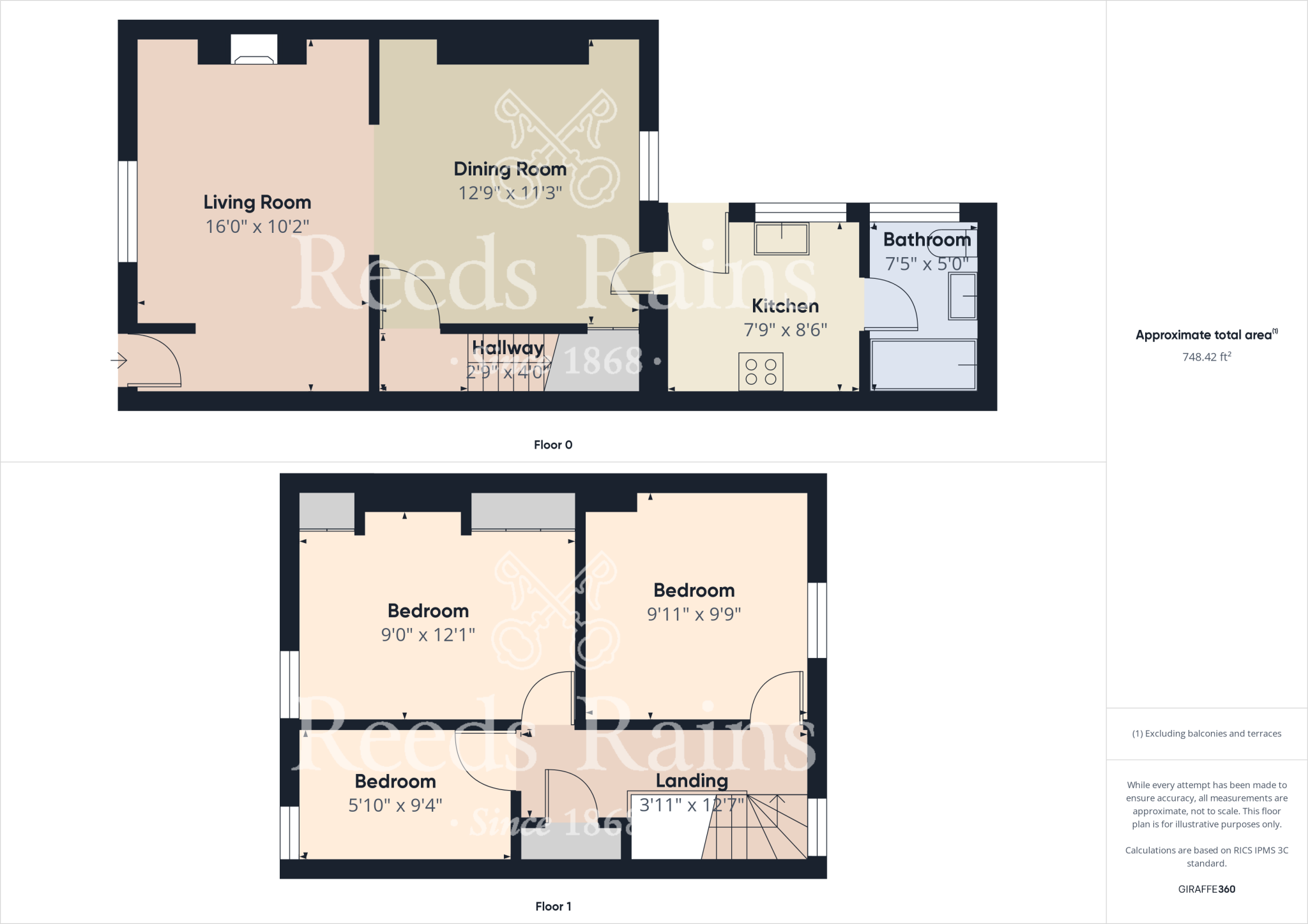
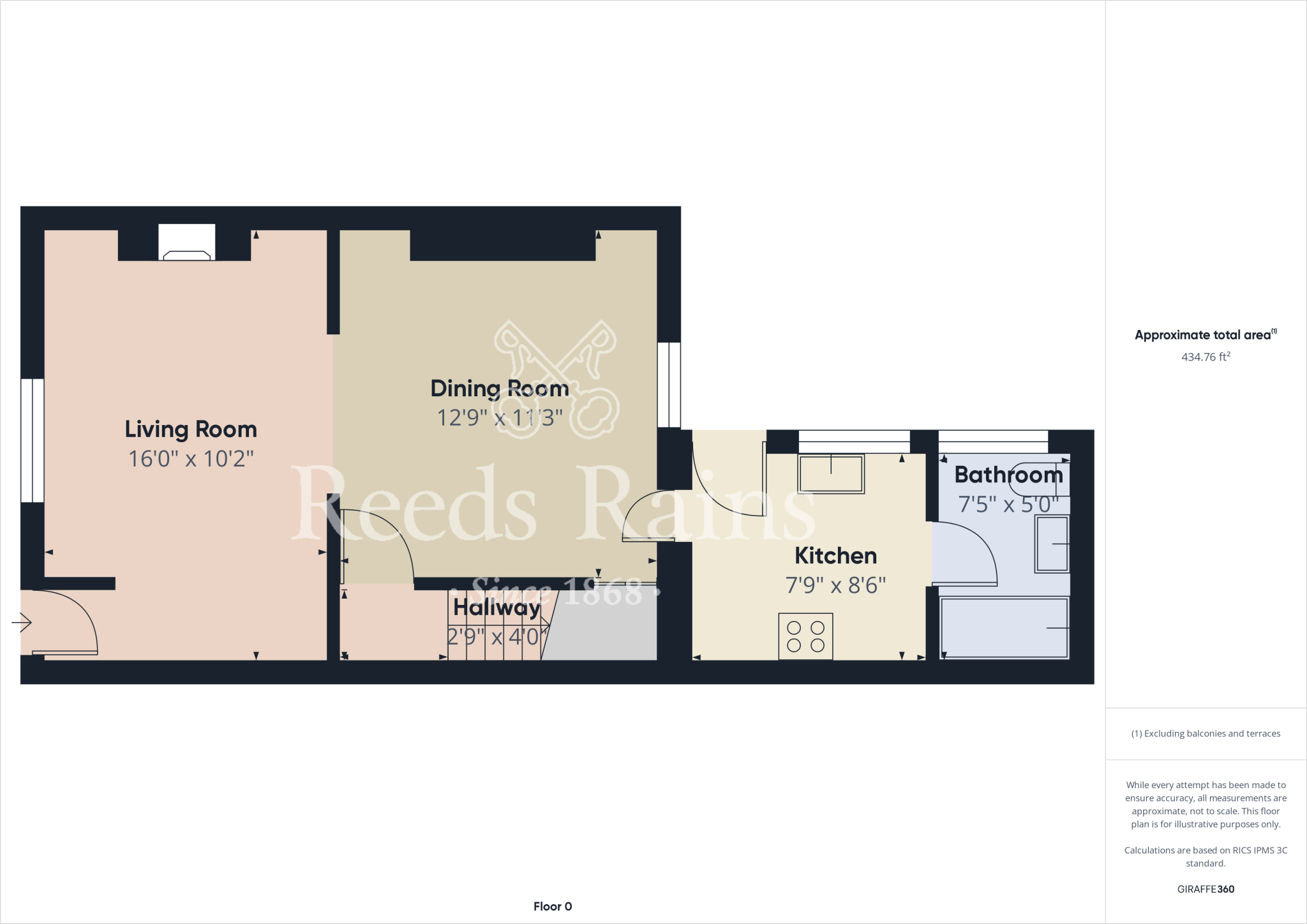
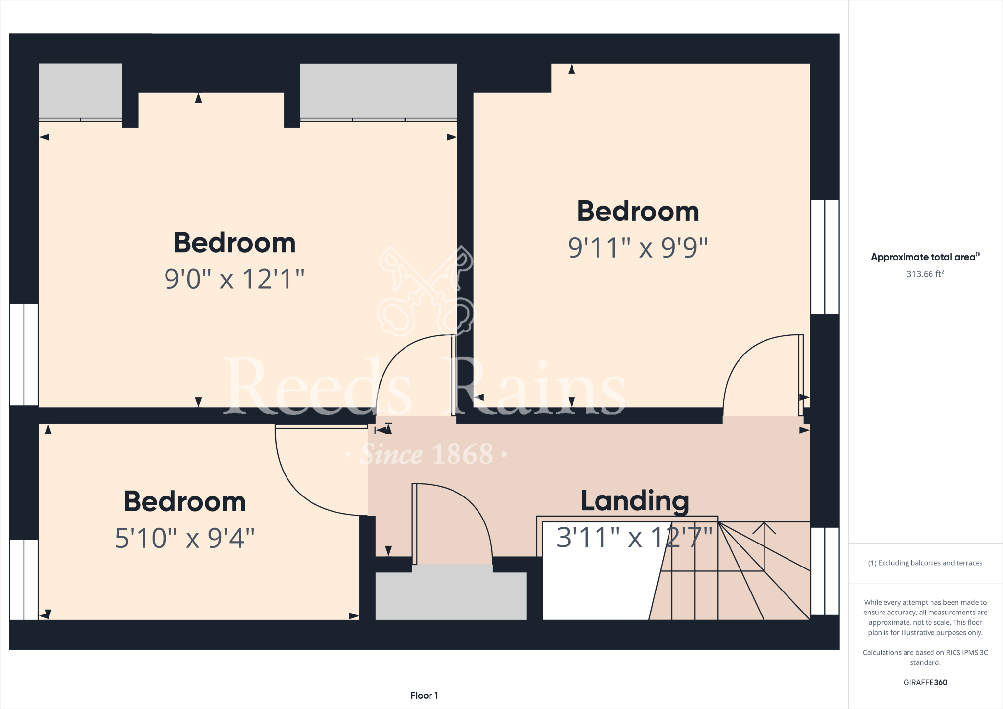
- Two-storey residential property with living, dining, kitchen and three bedrooms.
- Ground-floor layout with living, dining, kitchen, hallway and bathroom.
Rooms
- Living Room:
- Dining Room:
- Hallway:
- Kitchen:
- Bathroom:
- Bedroom:
- Bedroom:
- Bedroom:
- Landing:
- Living Room:
- Dining Room:
- Hallway:
- Kitchen:
- Bathroom:
- Bedroom:
- Bedroom:
- Bedroom:
- Landing:
Textual Property Features
Detected Visual Features
- Victorian
- terraced
- garden
- outdoor space
- fence
- urban
- semi-detached
- landscaping
- fencing
- patio
- play area
- natural surroundings
- rural
- privacy
EPC Details
- Fully double glazed
- Solid brick, as built, no insulation (assumed)
- Boiler and radiators, mains gas
- Low energy lighting in 78% of fixed outlets
- Solid, no insulation (assumed)
Nearby Schools
- Oakridge Community Primary School
- Saint Joseph's Catholic Primary School, A Catholic Voluntary Academy
- Staithes, Seton Community Primary School
- Hummersea Primary School
- Old Farm School
- Freebrough Academy
- Outwood Academy Bydales
- Lingdale Primary School
- Lockwood Primary School
- Handale Primary School
- Skelton Primary School
- Badger Hill Academy
- St Peter's Church of England Primary School
- Huntcliff School
- Whitecliffe Academy
- Saltburn Primary School
- Errington Primary School
Nearest General Shops
- Id: 841502677
- Tags:
- Addr:
- City: Skelton-In-Cleveland
- Postcode: TS12 2ZL
- Street: Pheasant Fields Lane
- Brand: Sue Ryder
- Brand:wikidata: Q7634271
- Brand:wikipedia: en:Sue Ryder (charity)
- Building: retail
- Name: Sue Ryder
- Shop: charity
- TagsNormalized:
- sue ryder
- retail
- charity
- shop
- Lat: 54.5670957
- Lon: -0.961336
- FullGeoHash: gcxq6jeur5zu
- PartitionGeoHash: gcxq
- Images:
- FoodStandards: null
- Distance: 4765
,- Id: 841502674
- Tags:
- Addr:
- City: Skelton-In-Cleveland
- Postcode: TS12 2ZL
- Street: Pheasant Fields Lane
- Brand: B&M
- Brand:wikidata: Q4836931
- Building: retail
- Contact:
- Website: https://www.bmstores.co.uk/stores/skelton-91
- Name: B&M & Garden Centre
- Shop: variety_store
- TagsNormalized:
- b&m
- retail
- garden centre
- variety store
- shop
- Lat: 54.5672815
- Lon: -0.9610335
- FullGeoHash: gcxq6jsjqq93
- PartitionGeoHash: gcxq
- Images:
- FoodStandards: null
- Distance: 4752.9
,- Id: 551020402
- Tags:
- Building: yes
- Name: Easington Service Station
- Shop: car_repair
- Shop_1: car
- TagsNormalized:
- Lat: 54.5524808
- Lon: -0.8549103
- FullGeoHash: gcxqkdcrppkx
- PartitionGeoHash: gcxq
- Images:
- FoodStandards: null
- Distance: 2335.9
}
Nearest Grocery shops
- Id: 274306733
- Tags:
- Addr:
- Housenumber: 45-47
- Postcode: TS12 2NJ
- Street: Byland Road
- Town: Skelton
- Brand: Sainsbury's
- Brand:wikidata: Q152096
- Fhrs:
- Name: Sainsbury's
- Shop: convenience
- Source:
- Website: https://stores.sainsburys.co.uk/4662/skelton-local
- TagsNormalized:
- sainsburys
- convenience
- shop
- Lat: 54.5610195
- Lon: -0.9695919
- FullGeoHash: gcxq3utbyz5y
- PartitionGeoHash: gcxq
- Images:
- FoodStandards:
- Id: 272863
- FHRSID: 272863
- LocalAuthorityBusinessID: 15177
- BusinessName: Sainsbury's
- BusinessType: Retailers - supermarkets/hypermarkets
- BusinessTypeID: 7840
- AddressLine1: null
- AddressLine2: 45-47 Byland Road
- AddressLine3: Skelton
- AddressLine4: null
- PostCode: TS12 2NJ
- RatingValue: 5
- RatingKey: fhrs_5_en-GB
- RatingDate: 2022-07-11
- LocalAuthorityCode: 860
- LocalAuthorityName: Redcar and Cleveland
- LocalAuthorityWebSite: http://www.redcar-cleveland.gov.uk
- LocalAuthorityEmailAddress: food_team@redcar-cleveland.gov.uk
- Scores:
- Hygiene: 0
- Structural: 0
- ConfidenceInManagement: 0
- NewRatingPending: false
- Geocode:
- Longitude: -0.96953400000000
- Latitude: 54.56157200000000
- Distance: 5126.5
,- Id: 1485034956
- Tags:
- TagsNormalized:
- Lat: 54.5612358
- Lon: -0.9695112
- FullGeoHash: gcxq3uw40z81
- PartitionGeoHash: gcxq
- Images:
- FoodStandards: null
- Distance: 5125.2
,- Id: 1586024819
- Tags:
- Addr:
- City: Brotton
- Country: GB
- Housenumber: 10
- Postcode: TS12 2PA
- Street: High Street
- Brand: Morrisons Daily
- Brand:wikidata: Q99752411
- Contact:
- Website: https://my.morrisons.com/storefinder/34748
- Fhrs:
- Name: Morrisons Daily
- Old_name: The Cooperative Food
- Operator: McColl's
- Operator:website: https://www.mccolls.co.uk/storelocator/brotton-10-high-street/
- Operator:wikidata: Q16997477
- Shop: convenience
- TagsNormalized:
- morrisons
- morrisons daily
- convenience
- shop
- Lat: 54.5669793
- Lon: -0.9393449
- FullGeoHash: gcxq6tegxwjw
- PartitionGeoHash: gcxq
- Images:
- FoodStandards: null
- Distance: 3439.2
}
Nearest Religious buildings
- Id: 145120630
- Tags:
- Addr:
- Housenumber: 39
- Postcode: TS13 4HA
- Street: High Street
- Amenity: place_of_worship
- Building: church
- Denomination: catholic
- Name: Saints Joseph and Cuthbert
- Religion: christian
- Source: local_knowledge
- Source:geometry: Bing
- TagsNormalized:
- place of worship
- church
- catholic
- christian
- Lat: 54.5541082
- Lon: -0.8834479
- FullGeoHash: gcxq7gk8wnve
- PartitionGeoHash: gcxq
- Images:
- FoodStandards: null
- Distance: 491.5
,- Id: 852012073
- Tags:
- Amenity: place_of_worship
- Building: church
- Denomination: anglican
- Name: St Hilda
- Religion: christian
- Wikidata: Q105106756
- TagsNormalized:
- place of worship
- church
- anglican
- christian
- Lat: 54.5521858
- Lon: -0.8975233
- FullGeoHash: gcxq7dfmw0qp
- PartitionGeoHash: gcxq
- Images:
- FoodStandards: null
- Distance: 455.8
,- Id: 145120626
- Tags:
- Amenity: place_of_worship
- Building: church
- Denomination: anglican
- Name: Saint Leonard's
- Religion: christian
- Source:
- Wikidata: Q26432493
- TagsNormalized:
- place of worship
- church
- anglican
- christian
- Lat: 54.5532144
- Lon: -0.8851951
- FullGeoHash: gcxq7g57t2nx
- PartitionGeoHash: gcxq
- Images:
- FoodStandards: null
- Distance: 384.3
}
Nearest Medical buildings
- Id: 411308951
- Tags:
- Addr:
- City: Saltburn By The Sea
- Postcode: TS12 2TG
- Street: Windermere Drive
- Amenity: doctors
- Building: yes
- Emergency: no
- Healthcare: doctor
- Name: Hillside Medical Centre
- Phone: +44 1287650430
- TagsNormalized:
- doctor
- doctors
- health
- healthcare
- Lat: 54.5631168
- Lon: -0.9810697
- FullGeoHash: gcxq3svt5qjm
- PartitionGeoHash: gcxq
- Images:
- FoodStandards: null
- Distance: 5894.9
,- Id: 1485034152
- Tags:
- TagsNormalized:
- Lat: 54.5630896
- Lon: -0.9810125
- FullGeoHash: gcxq3svthc05
- PartitionGeoHash: gcxq
- Images:
- FoodStandards: null
- Distance: 5890.7
,- Id: 99714921
- Tags:
- Amenity: hospital
- Name: East Cleveland Hospital
- Source: Bing
- TagsNormalized:
- Lat: 54.5649191
- Lon: -0.9365139
- FullGeoHash: gcxq6tnp9whs
- PartitionGeoHash: gcxq
- Images:
- FoodStandards: null
- Distance: 3179.3
,- Id: 408828019
- Tags:
- Addr:
- Amenity: doctors
- Building: yes
- Name: Woodside Surgery (Loftus)
- TagsNormalized:
- Lat: 54.5539515
- Lon: -0.8867822
- FullGeoHash: gcxq7g4rb3xk
- PartitionGeoHash: gcxq
- Images:
- FoodStandards: null
- Distance: 275.9
}
Nearest Leisure Facilities
- Id: 232235472
- Tags:
- Leisure: pitch
- Name: Loftus
- TagsNormalized:
- Lat: 54.558458
- Lon: -0.8868206
- FullGeoHash: gcxq7u44p9dw
- PartitionGeoHash: gcxq
- Images:
- FoodStandards: null
- Distance: 581.5
,- Id: 145117637
- Tags:
- Leisure: playground
- Source: Bing
- TagsNormalized:
- Lat: 54.5550649
- Lon: -0.8833205
- FullGeoHash: gcxq7gky31hq
- PartitionGeoHash: gcxq
- Images:
- FoodStandards: null
- Distance: 517.1
,- Id: 935729728
- Tags:
- TagsNormalized:
- Lat: 54.5564946
- Lon: -0.8878591
- FullGeoHash: gcxq7g9qx7sq
- PartitionGeoHash: gcxq
- Images:
- FoodStandards: null
- Distance: 360
,- Id: 145117635
- Tags:
- Leisure: park
- Source: Bing
- TagsNormalized:
- Lat: 54.5548634
- Lon: -0.8894083
- FullGeoHash: gcxq7g2m579h
- PartitionGeoHash: gcxq
- Images:
- FoodStandards: null
- Distance: 155.6
,- Id: 7658266754
- Tags:
- Addr:
- Country: GB
- Housenumber: 20
- Street: Zetland Road
- Town: Loftus
- Contact:
- Leisure: dance
- Name: Triple Dee Dance Studio
- Opening_hours: Mo-Fr 15:00-21:00
- TagsNormalized:
- Lat: 54.5540015
- Lon: -0.888691
- FullGeoHash: gcxq7g2b5fzy
- PartitionGeoHash: gcxq
- Images:
- FoodStandards: null
- Distance: 153.6
}
Nearest Tourist attractions
- Id: 236857573
- Tags:
- TagsNormalized:
- Lat: 54.555105
- Lon: -0.79717
- FullGeoHash: gcxqmg7w88dv
- PartitionGeoHash: gcxq
- Images:
- FoodStandards: null
- Distance: 6055.9
,- Id: 285135321
- Tags:
- Source: Bing;survey
- Tourism: picnic_site
- TagsNormalized:
- Lat: 54.5785808
- Lon: -0.9719667
- FullGeoHash: gcxq3zspr8ch
- PartitionGeoHash: gcxq
- Images:
- FoodStandards: null
- Distance: 5897
,- Id: 245690284
- Tags:
- Museum: history
- Name: Cleveland Ironstone Mining Museum
- Tourism: museum
- TagsNormalized:
- Lat: 54.5634971
- Lon: -0.8997806
- FullGeoHash: gcxq7sbz3t4f
- PartitionGeoHash: gcxq
- Images:
- FoodStandards: null
- Distance: 1212.1
}
Nearest Train stations
- Id: 1408427539
- Tags:
- Name: Danby
- Naptan:
- Network: National Rail
- Public_transport: station
- Railway: station
- Ref:
- Train: yes
- Uic_ref: 7000644
- Wikidata: Q2012537
- Wikipedia: en:Danby railway station
- TagsNormalized:
- Lat: 54.4661746
- Lon: -0.910998
- FullGeoHash: gcxmg728knye
- PartitionGeoHash: gcxm
- Images:
- FoodStandards: null
- Distance: 9832.7
,- Id: 1202940916
- Tags:
- Name: Commondale
- Naptan:
- Network: National Rail
- Operator: Northern Rail
- Public_transport: station
- Railway: station
- Ref:
- Uic_ref: 7000525
- Wikidata: Q1943197
- Wikipedia: en:Commondale railway station
- TagsNormalized:
- Lat: 54.4812297
- Lon: -0.9749222
- FullGeoHash: gcxmcy404tm6
- PartitionGeoHash: gcxm
- Images:
- FoodStandards: null
- Distance: 9720.6
,- Id: 1572979129
- Tags:
- Name: Saltburn
- Naptan:
- Network: National Rail
- Operator: Northern Rail
- Public_transport: station
- Railway: station
- Ref:
- Uic_ref: 7001928
- Wikidata: Q2033443
- Wikipedia: en:Saltburn railway station
- TagsNormalized:
- Lat: 54.5834185
- Lon: -0.9752233
- FullGeoHash: gcxq9b9g7wsy
- PartitionGeoHash: gcxq
- Images:
- FoodStandards: null
- Distance: 6344.6
,- Id: 7352783541
- Tags:
- Name: Pier
- Opening_hours:
- Public_transport: station
- Railway: station
- Train: yes
- Usage: tourism
- TagsNormalized:
- Lat: 54.5861191
- Lon: -0.9707315
- FullGeoHash: gcxq9cj5hq45
- PartitionGeoHash: gcxq
- Images:
- FoodStandards: null
- Distance: 6265.8
,- Id: 1693961295
- Tags:
- Funicular: yes
- Name: Town Station
- Public_transport: station
- Railway: station
- Usage: tourism
- TagsNormalized:
- Lat: 54.5856932
- Lon: -0.9709902
- FullGeoHash: gcxq9chbwq9p
- PartitionGeoHash: gcxq
- Images:
- FoodStandards: null
- Distance: 6252.5
}
Nearest Bus stations and stops
- Id: 843744822
- Tags:
- Bus: yes
- Highway: bus_stop
- Public_transport: platform
- Source: survey
- TagsNormalized:
- Lat: 54.561545
- Lon: -0.9785955
- FullGeoHash: gcxq3sxkj14m
- PartitionGeoHash: gcxq
- Images:
- FoodStandards: null
- Distance: 5709.2
,- Id: 7848704222
- Tags:
- Bus: yes
- Highway: bus_stop
- Public_transport: platform
- TagsNormalized:
- Lat: 54.5669654
- Lon: -0.9650435
- FullGeoHash: gcxq6j978ge7
- PartitionGeoHash: gcxq
- Images:
- FoodStandards: null
- Distance: 4988.6
,- Id: 5150360773
- Tags:
- Bus: yes
- Highway: bus_stop
- Public_transport: platform
- TagsNormalized:
- Lat: 54.5570455
- Lon: -0.8177785
- FullGeoHash: gcxqm7u9b6kj
- PartitionGeoHash: gcxq
- Images:
- FoodStandards: null
- Distance: 4738.6
,- Id: 7848704176
- Tags:
- Bus: yes
- Highway: bus_stop
- Public_transport: platform
- TagsNormalized:
- Lat: 54.5571924
- Lon: -0.9586863
- FullGeoHash: gcxq65vfsvz9
- PartitionGeoHash: gcxq
- Images:
- FoodStandards: null
- Distance: 4376.9
,- Id: 7848704175
- Tags:
- Bus: yes
- Highway: bus_stop
- Public_transport: platform
- TagsNormalized:
- Lat: 54.5577477
- Lon: -0.9572782
- FullGeoHash: gcxq65yvvv39
- PartitionGeoHash: gcxq
- Images:
- FoodStandards: null
- Distance: 4292.2
}
Nearest Hotels
- Id: 1767744588
- Tags:
- Name: Grinkle Park Hotel
- Tourism: hotel
- Wikidata: Q111368257
- TagsNormalized:
- Lat: 54.5227276
- Lon: -0.8556556
- FullGeoHash: gcxqht8cvv0f
- PartitionGeoHash: gcxq
- Images:
- FoodStandards: null
- Distance: 4145.4
,- Id: 1340528712
- Tags:
- Internet_access: yes
- Name: Hunley Hotel & Golf Club
- Tourism: hotel
- Website: http://www.hunleyhall.co.uk
- TagsNormalized:
- Lat: 54.5739089
- Lon: -0.9309919
- FullGeoHash: gcxq6yfh43fp
- PartitionGeoHash: gcxq
- Images:
- FoodStandards: null
- Distance: 3407.1
,- Id: 480103532
- Tags:
- Building: yes
- Tourism: hotel
- TagsNormalized:
- Lat: 54.5739589
- Lon: -0.922001
- FullGeoHash: gcxq7nbs7g61
- PartitionGeoHash: gcxq
- Images:
- FoodStandards: null
- Distance: 2997.4
}
Tags
- Victorian
- terraced
- garden
- outdoor space
- fence
- urban
- semi-detached
- garden
- outdoor space
- landscaping
- fencing
- patio
- play area
- natural surroundings
- rural
- privacy
Local Market Stats
- Average Price/sqft: £132
- Avg Income: £33100
- Social Housing: 3%
- Planning Success Rate: 91%
AirBnB Data
- 1km average: £70/night
- Listings in 1km: 3
Similar Properties
 3 bedroom terraced house for sale in High Row, Loftus, TS13 — £74,995 • 3 bed • 1 bath • 754 ft²
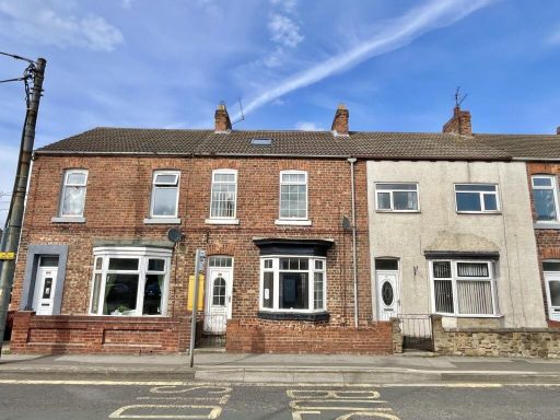 3 bedroom terraced house for sale in West Road, Loftus, Saltburn-by-the-Sea, North Yorkshire, TS13 — £65,000 • 3 bed • 1 bath • 1120 ft²
 3 bedroom house for sale in Gladstone Street, Loftus, TS13 — £85,000 • 3 bed • 1 bath • 948 ft²
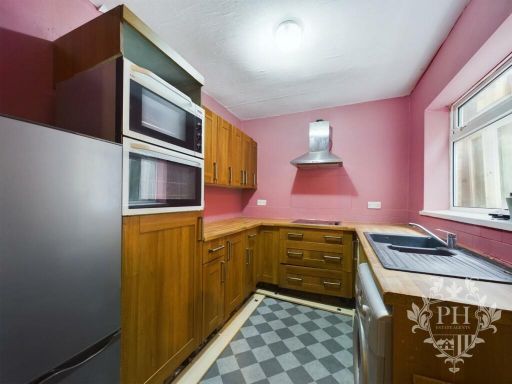 2 bedroom terraced house for sale in Liverton Road, Loftus, Saltburn-By-The-Sea, TS13 — £90,000 • 2 bed • 1 bath • 679 ft²
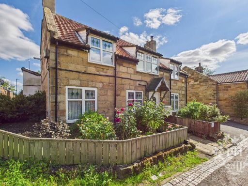 3 bedroom detached house for sale in Cleveland Street, Loftus, Saltburn-by-the-Sea, TS13 4JB, TS13 — £289,950 • 3 bed • 2 bath • 1604 ft²
 3 bedroom semi-detached house for sale in West Park Avenue, Loftus, Saltburn-By-The-Sea, TS13 — £135,000 • 3 bed • 1 bath • 1130 ft²
Meta
- {
"@context": "https://schema.org",
"@type": "Residence",
"name": "3 bedroom terraced house for sale in Railway Terrace, Loftu…",
"description": "",
"url": "https://propertypiper.co.uk/property/967b1f7d-86ed-47b1-8928-5ab878e1686b",
"image": "https://image-a.propertypiper.co.uk/f78e6779-44dd-45bc-b1ca-34b98d44f665-1024.jpeg",
"address": {
"@type": "PostalAddress",
"streetAddress": "3 RAILWAY TERRACE LOFTUS SALTBURN-BY-THE-SEA",
"postalCode": "TS13 4RA",
"addressLocality": "Redcar and Cleveland",
"addressRegion": "Middlesbrough South and East Cleveland",
"addressCountry": "England"
},
"geo": {
"@type": "GeoCoordinates",
"latitude": 54.55384090932385,
"longitude": -0.8910564189830438
},
"numberOfRooms": 3,
"numberOfBathroomsTotal": 1,
"floorSize": {
"@type": "QuantitativeValue",
"value": 748,
"unitCode": "FTK"
},
"offers": {
"@type": "Offer",
"price": 100000,
"priceCurrency": "GBP",
"availability": "https://schema.org/InStock"
},
"additionalProperty": [
{
"@type": "PropertyValue",
"name": "Feature",
"value": "Victorian"
},
{
"@type": "PropertyValue",
"name": "Feature",
"value": "terraced"
},
{
"@type": "PropertyValue",
"name": "Feature",
"value": "garden"
},
{
"@type": "PropertyValue",
"name": "Feature",
"value": "outdoor space"
},
{
"@type": "PropertyValue",
"name": "Feature",
"value": "fence"
},
{
"@type": "PropertyValue",
"name": "Feature",
"value": "urban"
},
{
"@type": "PropertyValue",
"name": "Feature",
"value": "semi-detached"
},
{
"@type": "PropertyValue",
"name": "Feature",
"value": "garden"
},
{
"@type": "PropertyValue",
"name": "Feature",
"value": "outdoor space"
},
{
"@type": "PropertyValue",
"name": "Feature",
"value": "landscaping"
},
{
"@type": "PropertyValue",
"name": "Feature",
"value": "fencing"
},
{
"@type": "PropertyValue",
"name": "Feature",
"value": "patio"
},
{
"@type": "PropertyValue",
"name": "Feature",
"value": "play area"
},
{
"@type": "PropertyValue",
"name": "Feature",
"value": "natural surroundings"
},
{
"@type": "PropertyValue",
"name": "Feature",
"value": "rural"
},
{
"@type": "PropertyValue",
"name": "Feature",
"value": "privacy"
}
]
}
High Res Floorplan Images
Compatible Floorplan Images
FloorplanImages Thumbnail