OX12 0BA - 4 bedroom detached house for sale in Denchworth Road, Wanta…
View on Property Piper
4 bedroom detached house for sale in Denchworth Road,
Wantage
OX12 0BA, OX12
Property Details
- Price: £550000
- Bedrooms: 4
- Bathrooms: 1
- Property Type: undefined
- Property SubType: undefined
Brochure Descriptions
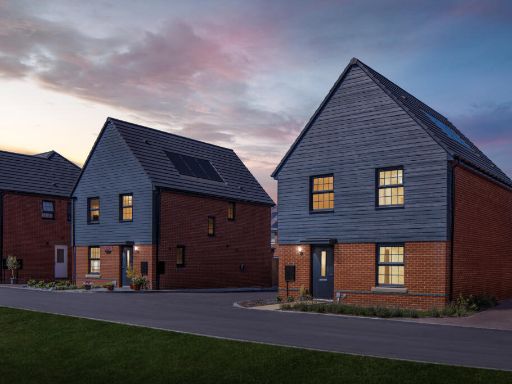
- No specific residential address is visible in the image. The image is a branded logo for a development or estate named "Brookside Meadows". There are no photos of the exterior, interior, garden or surrounding views to allow a detailed valuation. Based solely on the branding, this appears to be a residential development likely positioned to evoke green, semi-rural or suburban character ("brook" and "meadows" suggest proximity to open space or water). Room sizes, number of bedrooms, garden size and total plot area cannot be determined from this image. If this is a marketing cover image for a development, expect a range of dwelling types (e.g. houses and/or apartments) rather than a single property; confirm address, floorplans and site details for accurate valuation.
- No residential property images or address are visible on this page — the image is a branded cover for David Wilson Homes (brochure/marketing front) only. There is insufficient visual information to describe or value a specific property. As a property valuator: no data on property type, rooms, floorplan, external grounds, aspect or view is available; therefore an accurate size or condition assessment cannot be made. Recommend providing internal/external photographs, floorplans, the full postal address and any site area or floor area figures to enable a professional valuation and descriptive appraisal.
- No specific residential property or address is shown in the provided image. The image is a branded cover page for David Wilson Homes. It contains marketing copy describing the developer's offering (references to high-quality homes across the UK, a collection of second‑homes, spacious bedroom designs and high-specification finishes) but shows no photographs or floorplans of a particular home. From this page alone it is not possible to infer the exact room counts, garden size or overall square footage. The brochure suggests properties are aimed at the mid-to-high specification market and are located in desirable locations, but specific property details (views, garden size, room sizes) cannot be determined from the provided image.
Image Descriptions
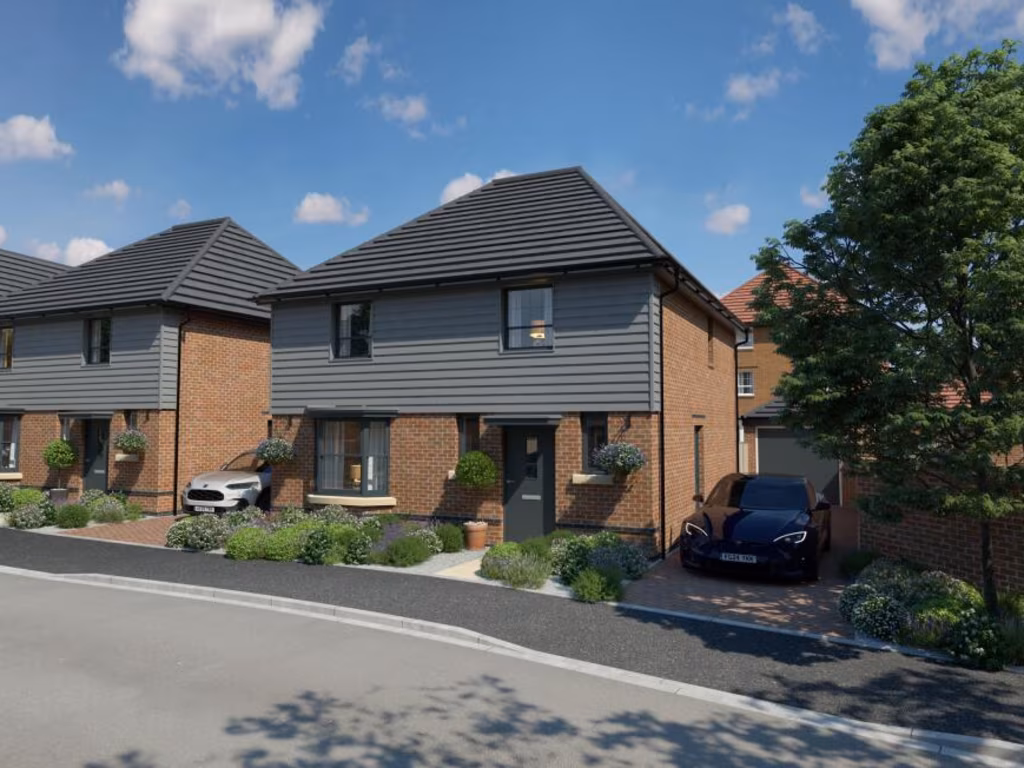
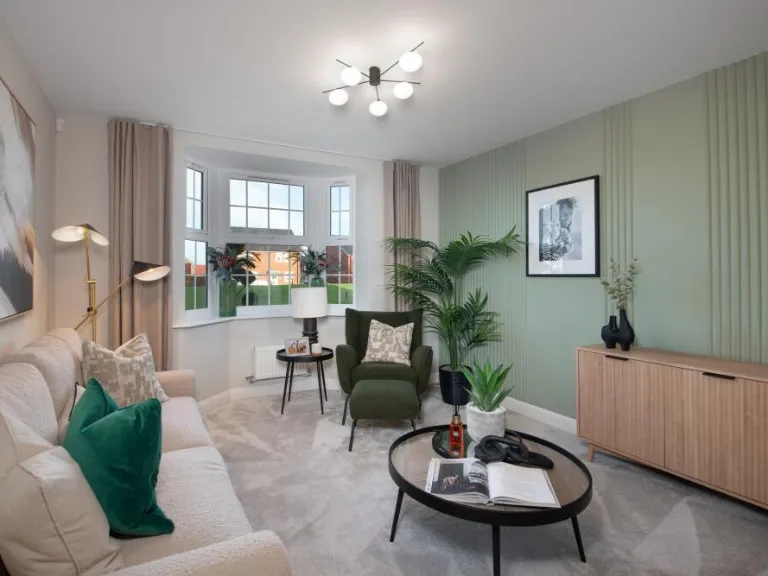
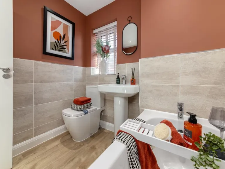
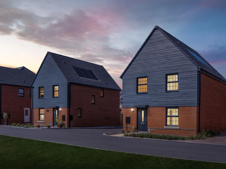
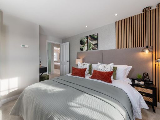
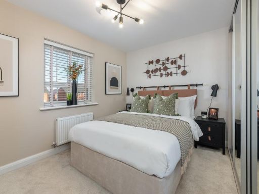
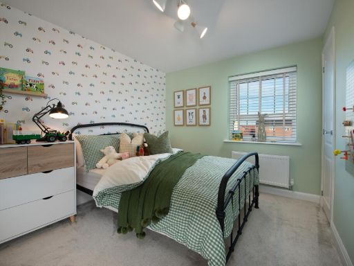
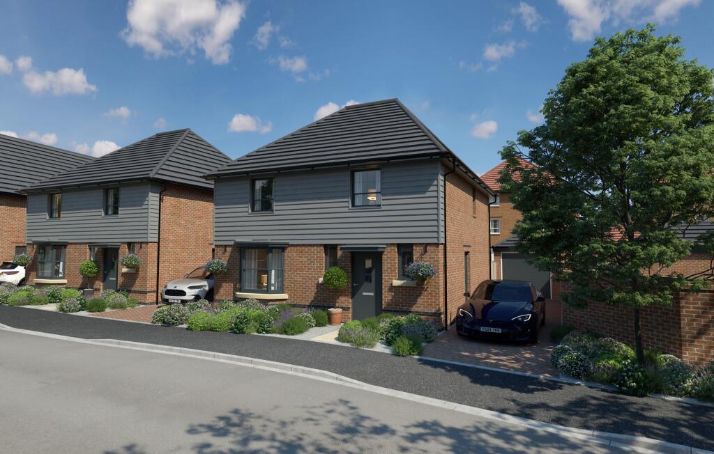
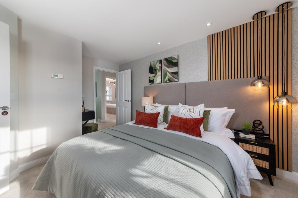
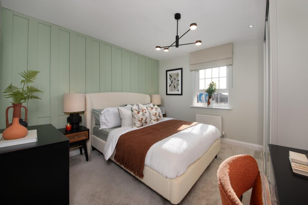
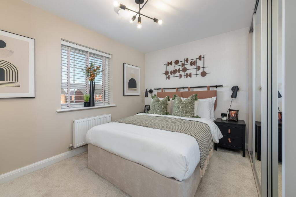
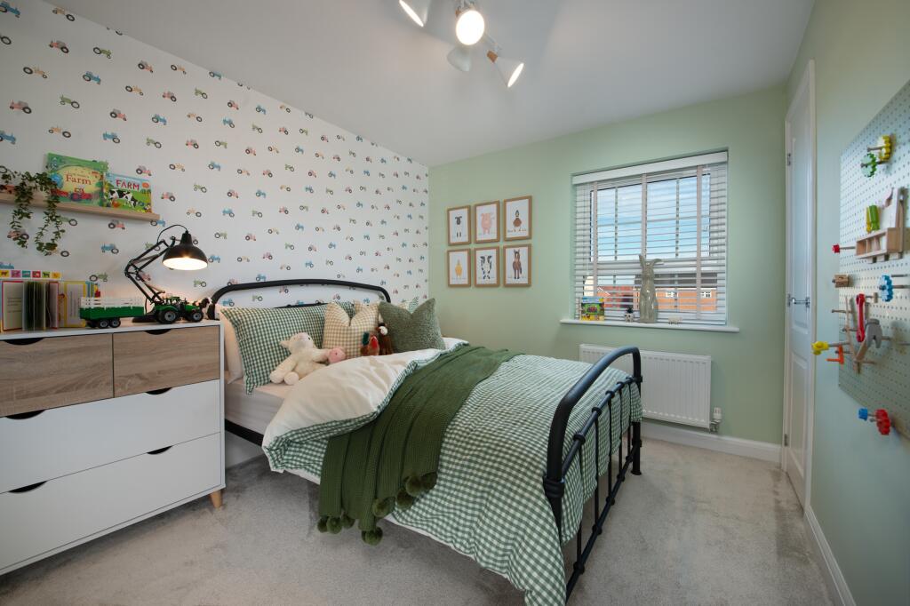
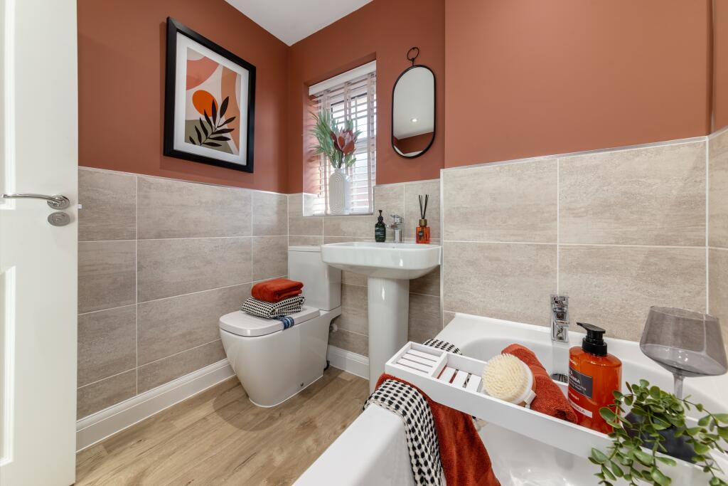
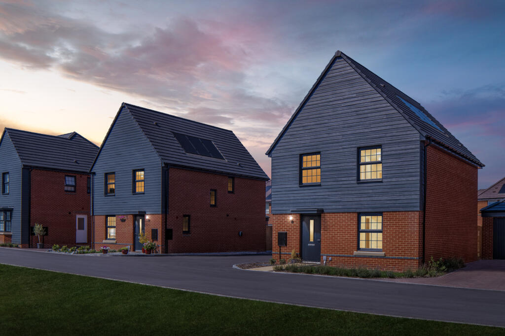
- modern detached house contemporary
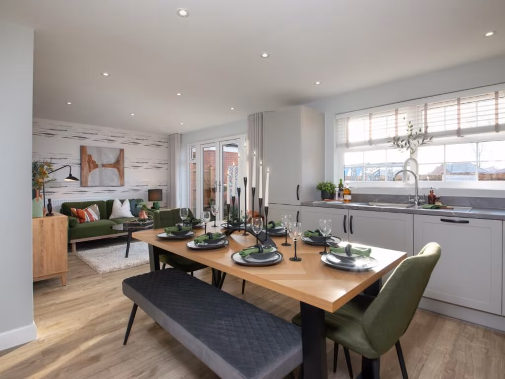
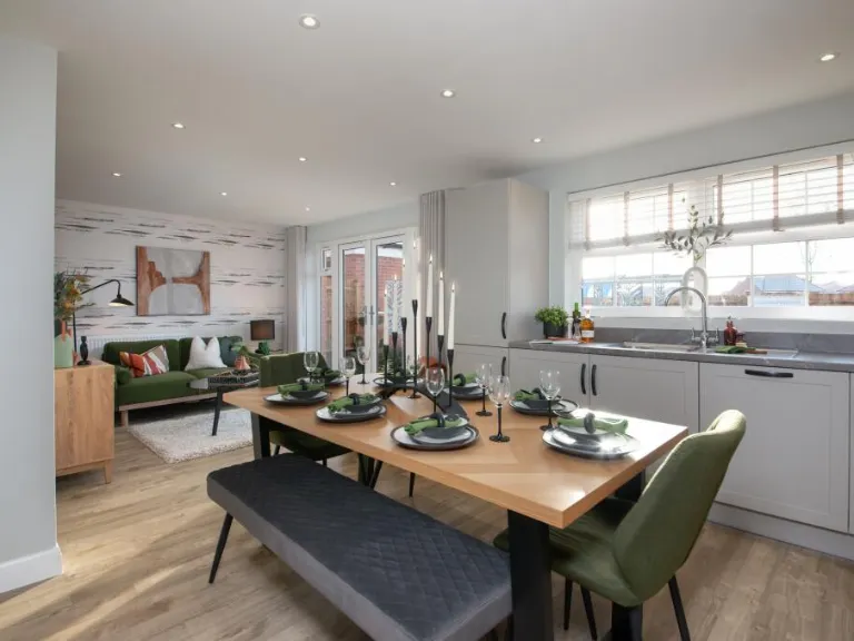
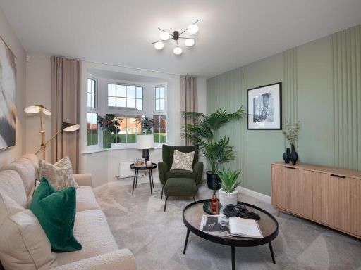
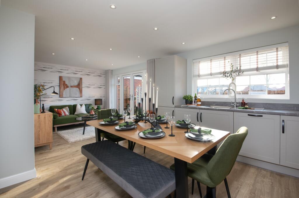
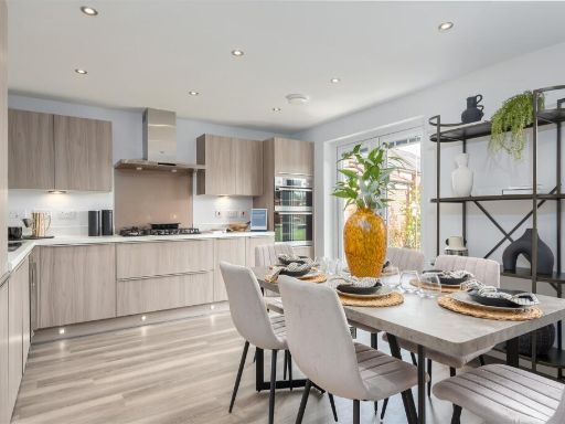
- open plan kitchen and dining area contemporary
Floorplan Description
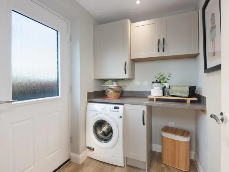
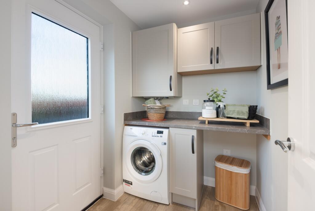
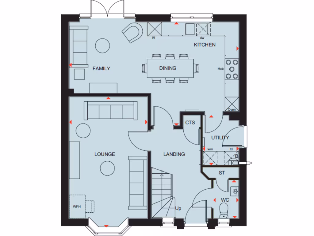
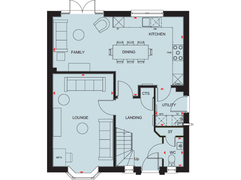
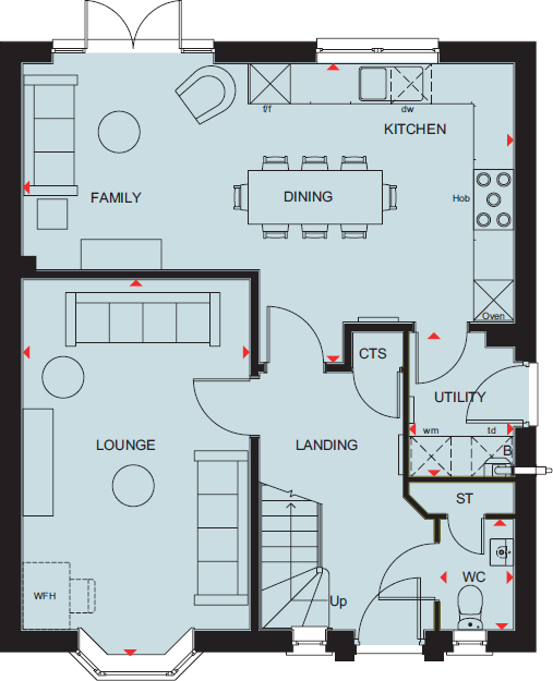
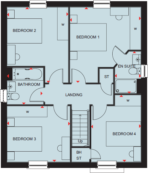
- Single-storey ground floor plan with open-plan kitchen/dining/family and separate lounge plus utility and WC.
Rooms
- FAMILY:
- KITCHEN:
- DINING:
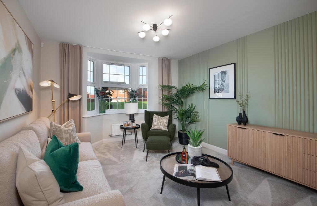
- LOUNGE:
- LANDING:
- CTS:
- UTILITY:
- ST:
- WC:
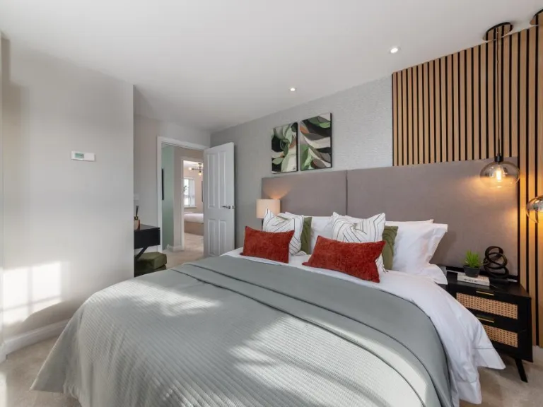
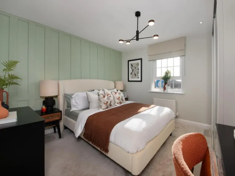
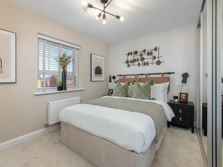
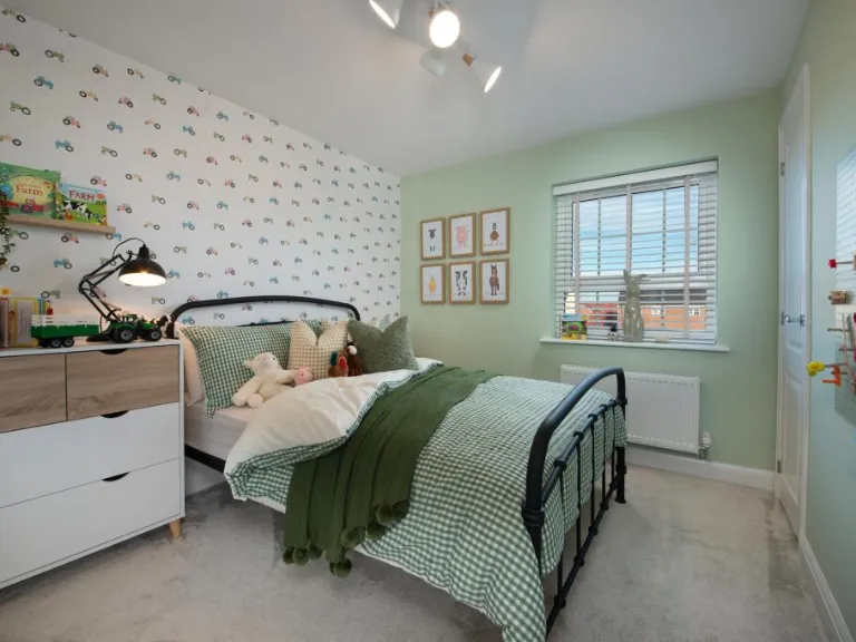
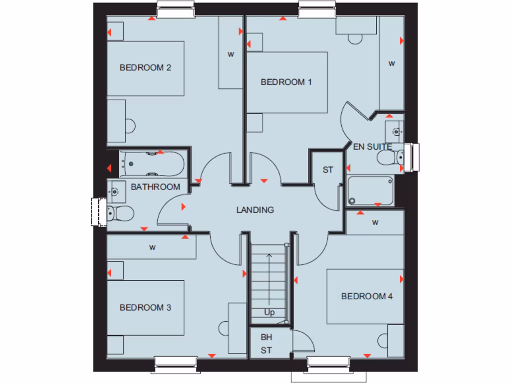
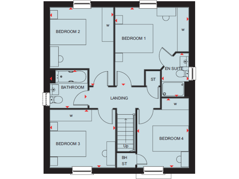
- BEDROOM 1:
- BEDROOM 2:
- BEDROOM 3:
- BEDROOM 4:
- BATHROOM:
- EN SUITE:
- LANDING:
- ST:
- BH ST:
Textual Property Features
Detected Visual Features
- modern
- detached
- contemporary
- new build
- garage
- driveway
- low maintenance
- suburban
- open plan living
- contemporary style
- modern kitchen
- dining area
- natural light
- integrated appliances
- hardwood flooring
Nearby Schools
- King Alfred's
- Grove Church of England School
- John Blandy Primary School
- Stockham Primary School
- Wantage Primary Academy
- St Johns CofE Academy
- Millbrook Primary School
- Wantage Church of England Primary School
- St Nicholas CofE Primary School
- Charlton Primary School
- Marcham Church of England (Voluntary Controlled) Primary School
- Buckland Church of England Primary School
- The Ridgeway Church of England (C) Primary School
- St Amand's Catholic Primary School
- The Hendreds Church of England School
- St James Church of England Primary School, Hanney
- Stanford In the Vale CofE Primary School
Nearest Bars And Restaurants
- Id: 188145932
- Tags:
- Addr:
- Postcode: OX12 0DX
- Street: Hyde Road
- Village: Denchworth
- Amenity: pub
- Building: yes
- Facebook: https://www.facebook.com/thefoxinndenchworth/
- Name: The Fox
- Phone: +441235868258
- Roof:
- Website: http://www.thefoxdenchworth.co.uk/
- Wikidata: Q26300706
- TagsNormalized:
- Lat: 51.6234599
- Lon: -1.4512899
- FullGeoHash: gcnvwvz0qqrv
- PartitionGeoHash: gcnv
- Images:
- FoodStandards: null
- Distance: 2002
,- Id: 395343072
- Tags:
- Amenity: fast_food
- Name: Fryday's Cafe
- TagsNormalized:
- Lat: 51.6038672
- Lon: -1.4464418
- FullGeoHash: gcnvx44wr6nf
- PartitionGeoHash: gcnv
- Images:
- FoodStandards: null
- Distance: 1752
,- Id: 509579687
- Tags:
- Amenity: pub
- Building: yes
- Name: The Volunteer
- Source: local_knowledge
- TagsNormalized:
- Lat: 51.6183762
- Lon: -1.4088381
- FullGeoHash: gcnvxuy4gdwp
- PartitionGeoHash: gcnv
- Images:
- FoodStandards: null
- Distance: 1338.4
,- Id: 418675604
- Tags:
- Amenity: pub
- Name: The Bell
- TagsNormalized:
- Lat: 51.607739
- Lon: -1.4216467
- FullGeoHash: gcnvxduuc5z6
- PartitionGeoHash: gcnv
- Images:
- FoodStandards: null
- Distance: 764.8
,- Id: 248927763
- Tags:
- Amenity: pub
- Name: The Bay Tree
- TagsNormalized:
- Lat: 51.6118016
- Lon: -1.4231106
- FullGeoHash: gcnvxeesx15u
- PartitionGeoHash: gcnv
- Images:
- FoodStandards: null
- Distance: 339.7
}
Nearest General Shops
- Id: 1032662233
- Tags:
- TagsNormalized:
- Lat: 51.6114515
- Lon: -1.3942304
- FullGeoHash: gcpj878f2pfk
- PartitionGeoHash: gcpj
- Images:
- FoodStandards: null
- Distance: 2263.5
,- Id: 479744516
- Tags:
- Addr:
- City: Wantage
- Housenumber: 1-3
- Postcode: OX12 7DB
- Street: Hans Avenue
- Building: yes
- Name: Wantage Motorist Centre
- Shop: car_parts
- TagsNormalized:
- Lat: 51.5938832
- Lon: -1.4212521
- FullGeoHash: gcnvx8mh4kvt
- PartitionGeoHash: gcnv
- Images:
- FoodStandards: null
- Distance: 2250.8
,- Id: 479785385
- Tags:
- Addr:
- City: Wantage
- Housename: Cherry Tree House
- Postcode: OX12 7DQ
- Street: Harcourt Road
- Building: yes
- Name: R & H Barker
- Shop: funeral_directors
- TagsNormalized:
- funeral
- funeral directors
- shop
- Lat: 51.5941679
- Lon: -1.4209539
- FullGeoHash: gcnvx8mmc3gz
- PartitionGeoHash: gcnv
- Images:
- FoodStandards: null
- Distance: 2223.3
}
Nearest Grocery shops
- Id: 479587424
- Tags:
- Addr:
- City: Wantage
- Housenumber: 39-40
- Postcode: OX12 8AW
- Street: Market Place
- Brand: McColl's
- Brand:wikidata: Q16997477
- Brand:wikipedia: en:McColl's
- Building: yes
- Contact:
- Website: https://www.mccolls.co.uk/storelocator/wantage-market-place/
- Name: McColl's
- Shop: convenience
- TagsNormalized:
- Lat: 51.5888764
- Lon: -1.4264415
- FullGeoHash: gcnvrx3qcx84
- PartitionGeoHash: gcnv
- Images:
- FoodStandards: null
- Distance: 2774.9
,- Id: 6964500972
- Tags:
- Amenity: post_office
- Name: Hanney Community Shop & Post Office
- Shop: convenience
- TagsNormalized:
- office
- post office
- shop
- convenience
- Lat: 51.6332891
- Lon: -1.4041145
- FullGeoHash: gcpj8p999y8q
- PartitionGeoHash: gcpj
- Images:
- FoodStandards: null
- Distance: 2670.4
,- Id: 477369510
- Tags:
- Addr:
- City: Wantage
- Housenumber: 8-12, 8a-12a
- Postcode: OX12 7EA
- Street: Barnards Way
- Building: yes
- Shop: convenience
- TagsNormalized:
- Lat: 51.5944392
- Lon: -1.4128792
- FullGeoHash: gcnvxb7pms8f
- PartitionGeoHash: gcnv
- Images:
- FoodStandards: null
- Distance: 2360.6
}
Nearest Supermarkets
- Id: 677055186
- Tags:
- Brand: Sainsbury's
- Brand:wikidata: Q152096
- Brand:wikipedia: en:Sainsbury's
- Name: Sainsbury's
- Note: Petrol station shop attached to larger store
- Shop: supermarket
- Website: https://stores.sainsburys.co.uk/2244/wantage
- TagsNormalized:
- sainsburys
- supermarket
- shop
- Lat: 51.5920587
- Lon: -1.4243511
- FullGeoHash: gcnvx84cd0yc
- PartitionGeoHash: gcnv
- Images:
- FoodStandards: null
- Distance: 2426.8
,- Id: 1073436350
- Tags:
- Name: Co-Op
- Shop: supermarket
- TagsNormalized:
- Lat: 51.6072252
- Lon: -1.4299968
- FullGeoHash: gcnvx6y9ysj1
- PartitionGeoHash: gcnv
- Images:
- FoodStandards: null
- Distance: 767.3
,- Id: 498338865
- Tags:
- Brand: Tesco Express
- Brand:wikidata: Q98456772
- Building: yes
- Contact:
- Website: https://www.tesco.com/store-locator/wantage/16-millbrook-square
- Name: Tesco Express
- Shop: supermarket
- Source: DigitalGlobe-Standard
- TagsNormalized:
- tesco
- tesco express
- supermarket
- shop
- Lat: 51.6099226
- Lon: -1.4219218
- FullGeoHash: gcnvxek9dffk
- PartitionGeoHash: gcnv
- Images:
- FoodStandards: null
- Distance: 549.3
}
Nearest Religious buildings
- Id: 8792835473
- Tags:
- Addr:
- Housename: The Health Centre
- Postcode: OX12 9BN
- Street: Mably Way
- Amenity: doctors
- Healthcare: doctor
- Name: Church Street Practice
- Website: https://wantagechurchstreet.co.uk/
- TagsNormalized:
- doctor
- doctors
- health
- healthcare
- church
- Lat: 51.5987176
- Lon: -1.4256838
- FullGeoHash: gcnvx93b74j5
- PartitionGeoHash: gcnv
- Images:
- FoodStandards: null
- Distance: 1682.3
,- Id: 823536595
- Tags:
- Amenity: place_of_worship
- Building: church
- Denomination: anglican
- Name: St. John the Baptist
- Religion: christian
- Wikidata: Q105073955
- TagsNormalized:
- place of worship
- church
- anglican
- baptist
- christian
- Lat: 51.6111482
- Lon: -1.4197433
- FullGeoHash: gcnvxew0tx6e
- PartitionGeoHash: gcnv
- Images:
- FoodStandards: null
- Distance: 570.6
,- Id: 204939423
- Tags:
- Addr:
- City: Wantage
- Country: GB
- Postcode: OX12 7PW
- Street: North Drive
- Amenity: school
- Capacity: 210
- Contact:
- Phone: +44 1235 769867
- Website: https://www.groveprimary.org
- Denomination: anglican
- Diocese: Diocese of Oxford
- Isced:
- Max_age: 11
- Min_age: 5
- Name: Grove Church of England School
- Ref:
- Ref:edubase:group: 4124
- Religion: christian
- School:
- Boarding: no
- Gender: mixed
- Selective: no
- Trust: yes
- Type: academy
- School:trust:name: Oxford Diocesan Schools Trust
- School:trust:type: multi_academy
- Wikidata: Q66230413
- TagsNormalized:
- school
- anglican
- church
- christian
- Lat: 51.6129699
- Lon: -1.4190689
- FullGeoHash: gcnvxeyem6cw
- PartitionGeoHash: gcnv
- Images:
- FoodStandards: null
- Distance: 541.5
}
Nearest Medical buildings
- Id: 479744536
- Tags:
- Addr:
- City: Wantage
- Housenumber: 3
- Parentstreet: Limborough Road
- Postcode: OX12 9AJ
- Street: Kings Walk
- Amenity: pharmacy
- Building: yes
- Healthcare: pharmacy
- Name: Cleggs Pharmacy
- TagsNormalized:
- Lat: 51.5895054
- Lon: -1.4268183
- FullGeoHash: gcnvrx948sz4
- PartitionGeoHash: gcnv
- Images:
- FoodStandards: null
- Distance: 2704.9
,- Id: 481663787
- Tags:
- Addr:
- City: Wantage
- Housename: Abivale
- Housenumber: 12
- Street: Belmont
- Amenity: veterinary
- Building: yes
- Name: Belmont Veterinary Surgery
- Operator: Abivale
- TagsNormalized:
- Lat: 51.5922487
- Lon: -1.4291473
- FullGeoHash: gcnvx2p6dknx
- PartitionGeoHash: gcnv
- Images:
- FoodStandards: null
- Distance: 2405.4
,- Id: 8792835472
- Tags:
- Addr:
- Housename: The Health Centre
- Postcode: OX12 9BN
- Street: Mably Way
- Amenity: doctors
- Healthcare: doctor
- Name: Newbury Street Practice
- Website: https://www.newburystreetpractice.co.uk/
- TagsNormalized:
- doctor
- doctors
- health
- healthcare
- Lat: 51.5987167
- Lon: -1.4260653
- FullGeoHash: gcnvx93863bw
- PartitionGeoHash: gcnv
- Images:
- FoodStandards: null
- Distance: 1681.4
,- Id: 109073810
- Tags:
- Amenity: clinic
- Building: yes
- Name: Wantage Health Centre
- TagsNormalized:
- clinic
- health
- health centre
- Lat: 51.5987224
- Lon: -1.4258647
- FullGeoHash: gcnvx938qgn0
- PartitionGeoHash: gcnv
- Images:
- FoodStandards: null
- Distance: 1681.2
}
Nearest Leisure Facilities
- Id: 528518448
- Tags:
- Leisure: pitch
- Sport: soccer
- TagsNormalized:
- Lat: 51.6034528
- Lon: -1.4270935
- FullGeoHash: gcnvxd0gfkcf
- PartitionGeoHash: gcnv
- Images:
- FoodStandards: null
- Distance: 1154.2
,- Id: 1137822241
- Tags:
- Barrier: fance
- Leisure: playground
- TagsNormalized:
- Lat: 51.6163134
- Lon: -1.4170429
- FullGeoHash: gcnvxu2nud0n
- PartitionGeoHash: gcnv
- Images:
- FoodStandards: null
- Distance: 727.2
,- Id: 482499855
- Tags:
- TagsNormalized:
- Lat: 51.6090524
- Lon: -1.4233186
- FullGeoHash: gcnvxe5sd28t
- PartitionGeoHash: gcnv
- Images:
- FoodStandards: null
- Distance: 582.9
,- Id: 248927759
- Tags:
- Created_by: JOSM
- Leisure: playground
- TagsNormalized:
- Lat: 51.6092415
- Lon: -1.4230861
- FullGeoHash: gcnvxe5txeyj
- PartitionGeoHash: gcnv
- Images:
- FoodStandards: null
- Distance: 570.8
,- Id: 1100665428
- Tags:
- TagsNormalized:
- Lat: 51.6131621
- Lon: -1.4214179
- FullGeoHash: gcnvxeuuqwcb
- PartitionGeoHash: gcnv
- Images:
- FoodStandards: null
- Distance: 378.1
}
Nearest Tourist attractions
- Id: 479922244
- Tags:
- Addr:
- City: Wantage
- Housenumber: 19
- Postcode: OX12 8BL
- Street: Church Street
- Building: yes
- Name: Vale and Downland Museum and Visitor Centre
- Tourism: museum
- Wikidata: Q7909507
- Wikipedia: en:Vale and Downland Museum
- TagsNormalized:
- Lat: 51.5879726
- Lon: -1.4282548
- FullGeoHash: gcnvrrrcxr05
- PartitionGeoHash: gcnv
- Images:
- FoodStandards: null
- Distance: 2877.1
,- Id: 389860444
- Tags:
- Name: Woodhill Lane Caravan Park
- Tourism: caravan_site
- TagsNormalized:
- Lat: 51.5974576
- Lon: -1.4556568
- FullGeoHash: gcnvwch0bxpx
- PartitionGeoHash: gcnv
- Images:
- FoodStandards: null
- Distance: 2700
,- Id: 482501979
- Tags:
- Addr:
- City: Wantage
- Housename: The Sack House
- Street: Mill Street
- Building: yes
- Name: The Sack House
- Tourism: museum
- TagsNormalized:
- Lat: 51.5903164
- Lon: -1.4287688
- FullGeoHash: gcnvrrxx7k0b
- PartitionGeoHash: gcnv
- Images:
- FoodStandards: null
- Distance: 2618.3
}
Nearest Train stations
- Id: 5784071207
- Tags:
- Name: Main Line Platform
- Naptan:
- Operator: Didcot Railway Centre
- Public_transport: station
- Railway: station
- Railway:preserved: yes
- Usage: tourism
- TagsNormalized:
- Lat: 51.6118363
- Lon: -1.2419808
- FullGeoHash: gcpjeexsexxg
- PartitionGeoHash: gcpj
- Images:
- FoodStandards: null
- Distance: 12762.6
,- Id: 6605149662
- Tags:
- Addr:
- City: Didcot
- Postcode: OX11 7NR
- Street: Station Road
- Name: Didcot Parkway
- Naptan:
- Network: National Rail
- Public_transport: station
- Railway: station
- Ref:
- Uic_ref: 7000651
- Wikipedia: en:Didcot Parkway railway station
- TagsNormalized:
- Lat: 51.6109222
- Lon: -1.24295
- FullGeoHash: gcpjeeqzmjjr
- PartitionGeoHash: gcpj
- Images:
- FoodStandards: null
- Distance: 12698
,- Id: 3859688699
- Tags:
- Name: Oxford Road
- Public_transport: station
- Railway: station
- Railway:preserved: yes
- Usage: tourism
- Wheelchair: limited
- TagsNormalized:
- Lat: 51.6175522
- Lon: -1.2453816
- FullGeoHash: gcpjestnh90h
- PartitionGeoHash: gcpj
- Images:
- FoodStandards: null
- Distance: 12531.9
,- Id: 5455448905
- Tags:
- Name: Burlescombe
- Public_transport: station
- Railway: station
- Railway:preserved: yes
- Usage: tourism
- TagsNormalized:
- Lat: 51.6174907
- Lon: -1.2459129
- FullGeoHash: gcpjessv8jsj
- PartitionGeoHash: gcpj
- Images:
- FoodStandards: null
- Distance: 12495
,- Id: 5784073934
- Tags:
- Name: Didcot Halt
- Operator: Didcot Railway Centre
- Public_transport: station
- Railway: station
- Service: preserved
- Usage: tourism
- Wheelchair: limited
- TagsNormalized:
- Lat: 51.6143946
- Lon: -1.2458686
- FullGeoHash: gcpjeshg9ht0
- PartitionGeoHash: gcpj
- Images:
- FoodStandards: null
- Distance: 12492.1
}
Nearest Hotels
- Id: 947717029
- Tags:
- Landuse: commercial
- Name: Steventon House Hotel
- Tourism: hotel
- TagsNormalized:
- Lat: 51.6133727
- Lon: -1.312408
- FullGeoHash: gcpjd5umdwj8
- PartitionGeoHash: gcpj
- Images:
- FoodStandards: null
- Distance: 7897.8
,- Id: 698169222
- Tags:
- Leisure: garden
- Name: Milton Hill House
- Source: Bing
- Surface: grass
- Tourism: hotel
- TagsNormalized:
- Lat: 51.6062747
- Lon: -1.3164188
- FullGeoHash: gcpjd49km4yg
- PartitionGeoHash: gcpj
- Images:
- FoodStandards: null
- Distance: 7667.5
,- Id: 479915462
- Tags:
- Addr:
- City: Wantage
- Housenumber: 14
- Postcode: OX12 8AB
- Street: Market Place
- Amenity: pub
- Building: yes
- Name: The Bear Hotel
- Tourism: hotel
- Wikidata: Q26300670
- TagsNormalized:
- Lat: 51.5881942
- Lon: -1.4270528
- FullGeoHash: gcnvrx2g522m
- PartitionGeoHash: gcnv
- Images:
- FoodStandards: null
- Distance: 2850.8
}
Tags
- modern
- detached
- contemporary
- new build
- garage
- driveway
- low maintenance
- suburban
- open plan living
- contemporary style
- modern kitchen
- dining area
- natural light
- integrated appliances
- hardwood flooring
Local Market Stats
- Average Price/sqft: £345
- Avg Income: £56700
- Rental Yield: 4.1%
- Social Housing: 11%
- Planning Success Rate: 92%
Similar Properties
 4 bedroom detached house for sale in Denchworth Road,
Wantage
OX12 0BA, OX12 — £470,000 • 4 bed • 1 bath • 838 ft²
4 bedroom detached house for sale in Denchworth Road,
Wantage
OX12 0BA, OX12 — £470,000 • 4 bed • 1 bath • 838 ft²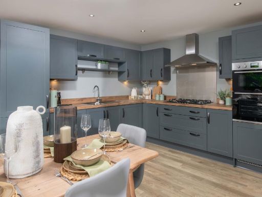 4 bedroom detached house for sale in Denchworth Road,
Wantage
OX12 0BA, OX12 — £520,000 • 4 bed • 1 bath • 1100 ft²
4 bedroom detached house for sale in Denchworth Road,
Wantage
OX12 0BA, OX12 — £520,000 • 4 bed • 1 bath • 1100 ft²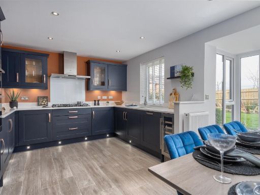 4 bedroom detached house for sale in Denchworth Road,
Wantage
OX12 0BA, OX12 — £600,000 • 4 bed • 1 bath • 1229 ft²
4 bedroom detached house for sale in Denchworth Road,
Wantage
OX12 0BA, OX12 — £600,000 • 4 bed • 1 bath • 1229 ft²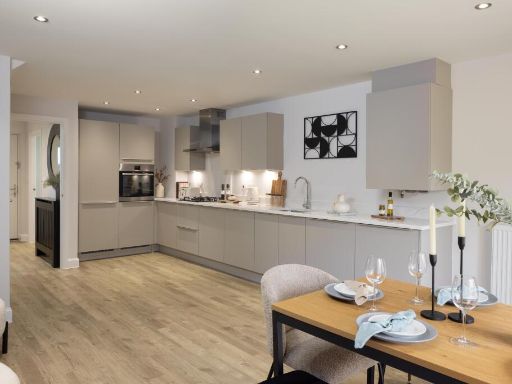 3 bedroom semi-detached house for sale in Denchworth Road,
Wantage
OX12 0BA, OX12 — £438,000 • 3 bed • 1 bath • 807 ft²
3 bedroom semi-detached house for sale in Denchworth Road,
Wantage
OX12 0BA, OX12 — £438,000 • 3 bed • 1 bath • 807 ft²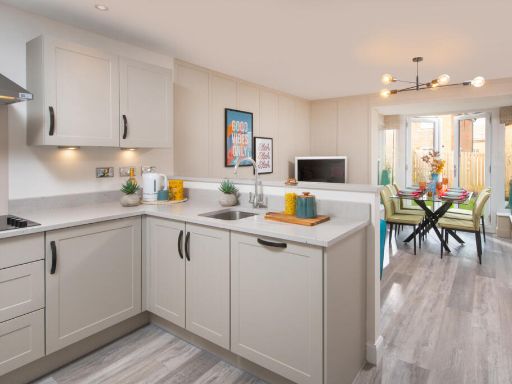 3 bedroom semi-detached house for sale in Denchworth Road,
Wantage
OX12 0BA, OX12 — £430,000 • 3 bed • 1 bath • 807 ft²
3 bedroom semi-detached house for sale in Denchworth Road,
Wantage
OX12 0BA, OX12 — £430,000 • 3 bed • 1 bath • 807 ft²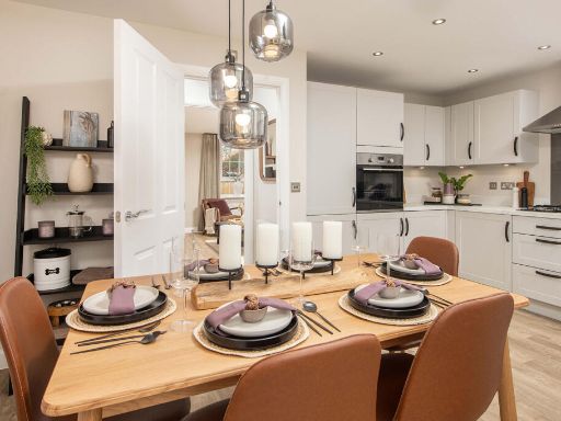 3 bedroom semi-detached house for sale in Denchworth Road,
Wantage
OX12 0BA, OX12 — £417,000 • 3 bed • 1 bath • 1011 ft²
3 bedroom semi-detached house for sale in Denchworth Road,
Wantage
OX12 0BA, OX12 — £417,000 • 3 bed • 1 bath • 1011 ft²
Meta
- {
"@context": "https://schema.org",
"@type": "Residence",
"name": "4 bedroom detached house for sale in Denchworth Road, Wanta…",
"description": "",
"url": "https://propertypiper.co.uk/property/8d0a594f-3d87-412a-80ec-f4c0d9febd9e",
"image": "https://image-a.propertypiper.co.uk/ad78d18e-73ee-417f-953f-dd10abfcbd67-1024.jpeg",
"address": {
"@type": "PostalAddress",
"streetAddress": "1 THE MAPLES GROVE WANTAGE",
"postalCode": "OX12 0BA",
"addressLocality": "Vale of White Horse",
"addressRegion": "Wantage",
"addressCountry": "England"
},
"geo": {
"@type": "GeoCoordinates",
"latitude": 51.6138312,
"longitude": -1.4267873
},
"numberOfRooms": 4,
"numberOfBathroomsTotal": 1,
"floorSize": {
"@type": "QuantitativeValue",
"value": 1174,
"unitCode": "FTK"
},
"offers": {
"@type": "Offer",
"price": 550000,
"priceCurrency": "GBP",
"availability": "https://schema.org/InStock"
},
"additionalProperty": [
{
"@type": "PropertyValue",
"name": "Feature",
"value": "modern"
},
{
"@type": "PropertyValue",
"name": "Feature",
"value": "detached"
},
{
"@type": "PropertyValue",
"name": "Feature",
"value": "contemporary"
},
{
"@type": "PropertyValue",
"name": "Feature",
"value": "new build"
},
{
"@type": "PropertyValue",
"name": "Feature",
"value": "garage"
},
{
"@type": "PropertyValue",
"name": "Feature",
"value": "driveway"
},
{
"@type": "PropertyValue",
"name": "Feature",
"value": "low maintenance"
},
{
"@type": "PropertyValue",
"name": "Feature",
"value": "suburban"
},
{
"@type": "PropertyValue",
"name": "Feature",
"value": "open plan living"
},
{
"@type": "PropertyValue",
"name": "Feature",
"value": "contemporary style"
},
{
"@type": "PropertyValue",
"name": "Feature",
"value": "modern kitchen"
},
{
"@type": "PropertyValue",
"name": "Feature",
"value": "dining area"
},
{
"@type": "PropertyValue",
"name": "Feature",
"value": "natural light"
},
{
"@type": "PropertyValue",
"name": "Feature",
"value": "integrated appliances"
},
{
"@type": "PropertyValue",
"name": "Feature",
"value": "hardwood flooring"
}
]
}
High Res Floorplan Images
Compatible Floorplan Images
FloorplanImages Thumbnail