WN2 1YX - 2 bedroom detached bungalow for sale in Scot Lane, Aspull,…
View on Property Piper
2 bedroom detached bungalow for sale in Scot Lane, Aspull, WN2 1YX, WN2
Property Details
- Price: £225000
- Bedrooms: 2
- Bathrooms: 1
- Property Type: undefined
- Property SubType: undefined
Brochure Descriptions
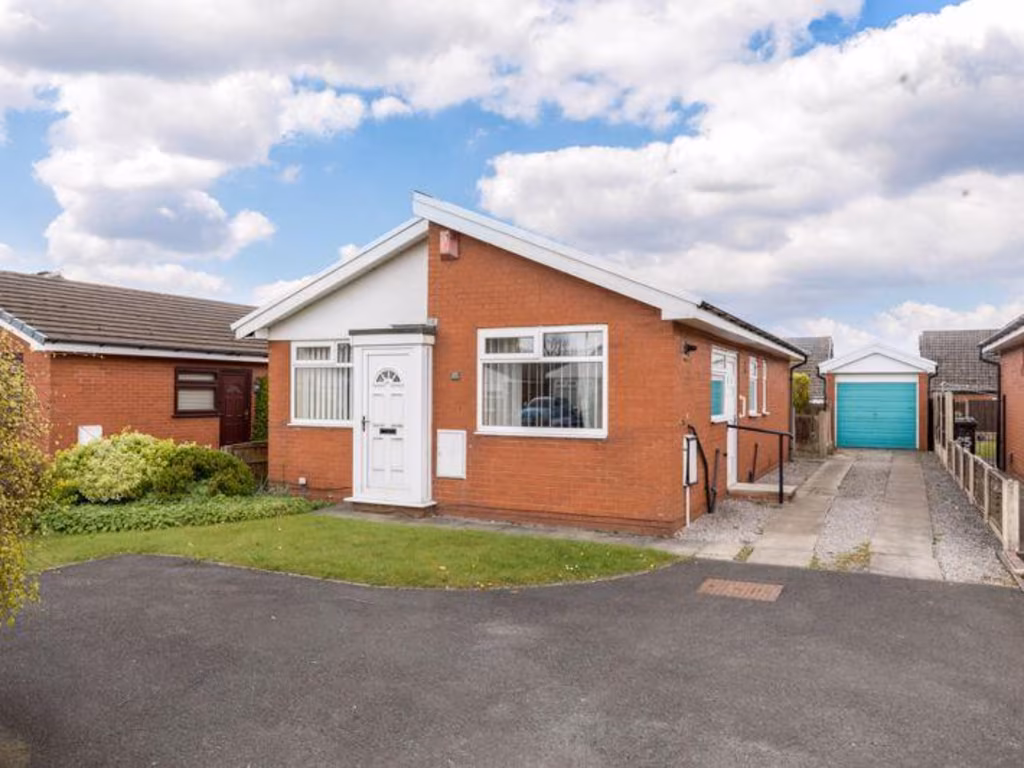
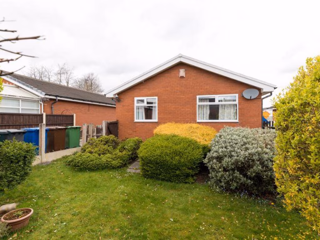
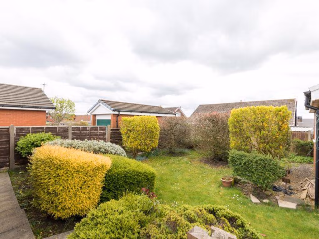
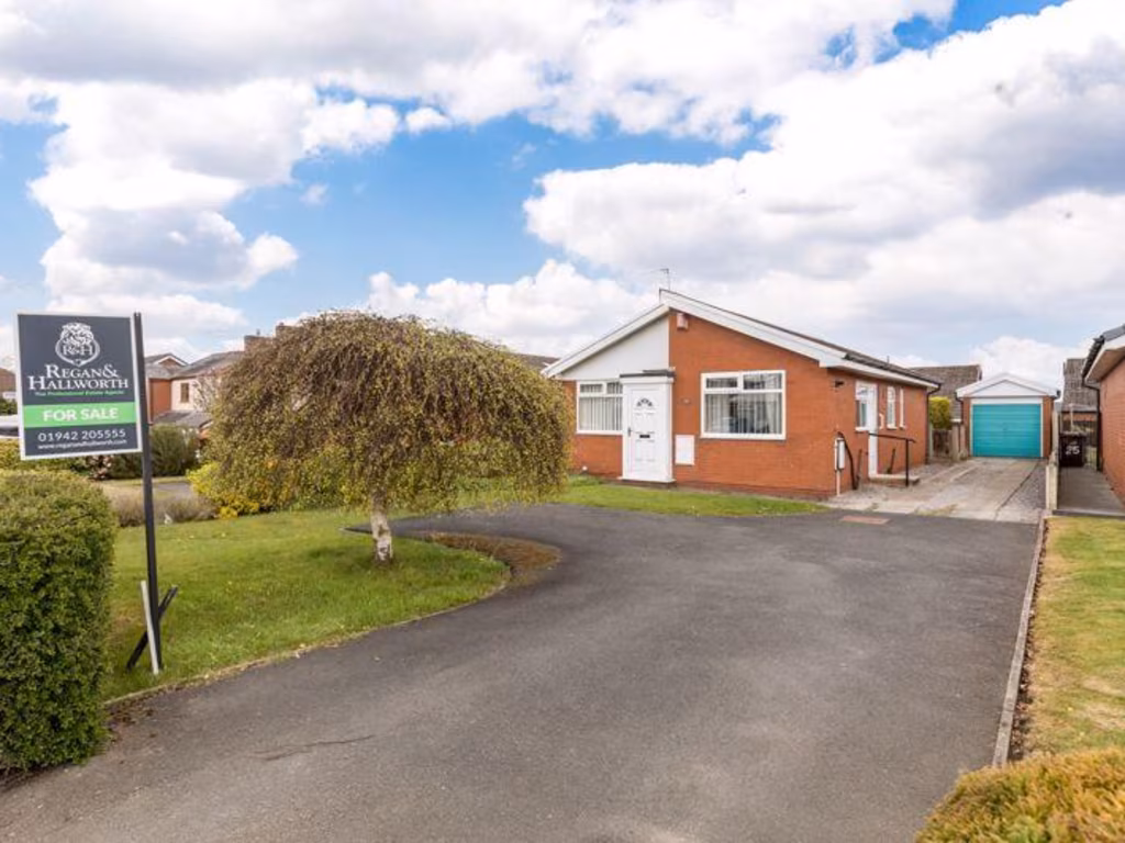
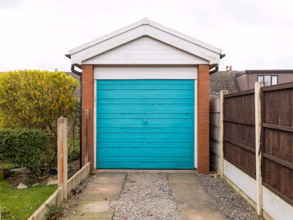
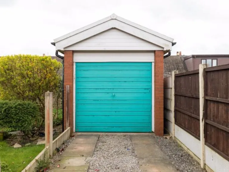
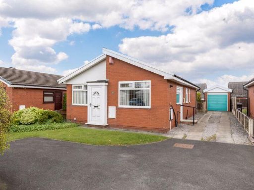
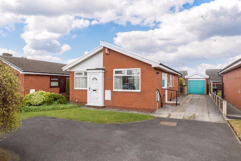
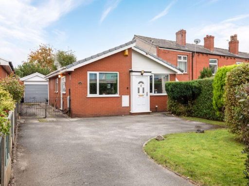
- This charming detached bungalow presents an ideal living space suitable for family life or a quiet retirement. Nestled within a peaceful neighborhood, the property boasts a compact yet well-maintained garden providing just enough greenery without overwhelming maintenance. With a driveway leading to a detached single garage, convenience is assured for car owners or additional storage needs. The bungalow, with its clean red brick exterior, features a pitched roof and a front-facing window that allows natural light to illuminate the interior. The property's overall footprint suggests a modest yet ample residence with practical internal room planning that offers good utility and ease of movement.
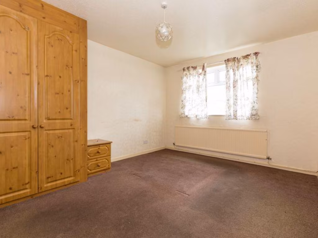
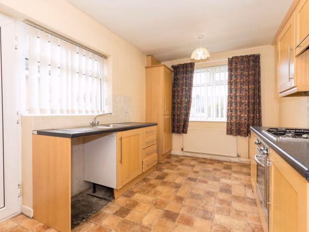
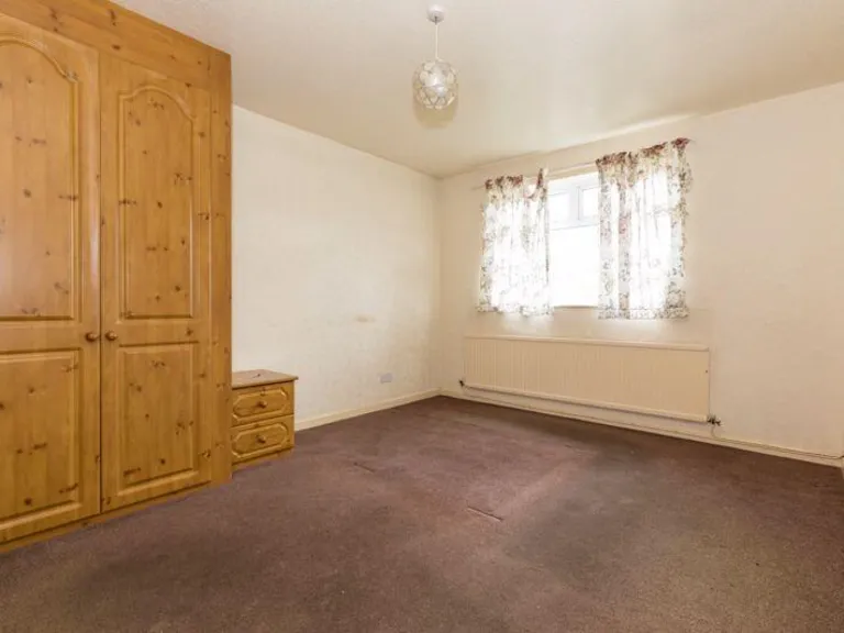
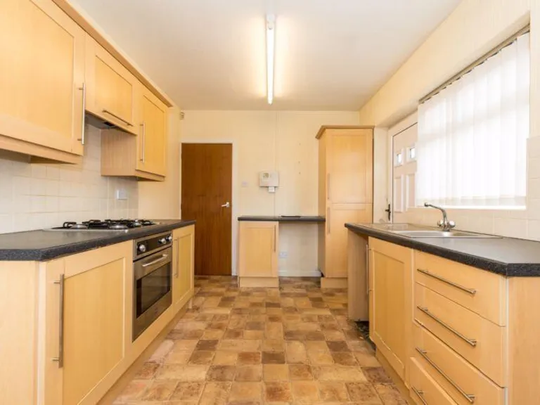
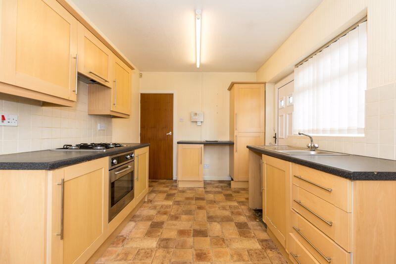
- This property is a well-proportioned home with a total floor area of 822 square feet, offering a functional layout suitable for small families or as a starter home. The residence includes two bedrooms, one of which is notably larger, ideal for creating a master suite. The lounge area is of medium size, providing enough space for comfortable family gatherings. The kitchen is compact yet efficient, connecting seamlessly to the dining area. Complementing the indoor space is a solitary garage measuring a modest 8'2" x 17'2", suitable for a single vehicle or storage. Overall, the property layout maximizes available space efficiently without compromising on conveniences.
Image Descriptions
- detached bungalow mid-20th century
- detached house 1970s bungalow
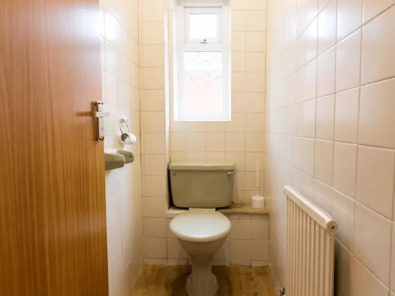
Rooms
- Bedroom:
- Bedroom:
- Lounge:
- Kitchen:
Textual Property Features
- Has Garden
- Chain Free
- Is Retirement
- Success
Detected Visual Features
- detached
- bungalow
- brick
- mid-20th century
- single-storey
- driveway
- garage
- garden
- front lawn
- 1970s
- lawn
- small garden
- residential area
Nearby Schools
- Outwood Academy Hindley
- Dean Trust Rose Bridge
- St Mary and St John Catholic Primary School
- Woodfield Primary School
- Our Lady's RC Primary School Wigan
- Beacon Primary School
- St Mary's CofE Primary School
- Hindley Junior and Infant School
- Hindley All Saints CofE Primary School
- St Benedict's Catholic Primary School Hindley
- St Catharine's CofE Primary School
- Holy Family Catholic Primary School, New Springs, Wigan
- Aspull Church Primary School
- Blackrod Primary School
- Blackrod Anglican/Methodist Primary School
- St Catherine's CofE Primary School
- St Peter's Church of England Primary School, Hindley
- Britannia Bridge Primary School
- St William's Catholic Primary School
- Ince CofE Primary School
- Mab's Cross Primary School
- St David Haigh and Aspull CofE Primary School
- St Joseph's Catholic Primary School, Anderton
- Three Towers Alternative Provision Academy
- Castle Hill St Philip's CofE Primary School
- St Patrick's Catholic Primary School
- Canon Sharples Church of England Primary School and Nursery
Nearest Bars And Restaurants
- Id: 1063530407
- Tags:
- Amenity: pub
- Building: yes
- Name: The Collier's Arms
- TagsNormalized:
- Lat: 53.5612417
- Lon: -2.598654
- FullGeoHash: gcw0sye8ygp5
- PartitionGeoHash: gcw0
- Images:
- FoodStandards: null
- Distance: 1404.9
,- Id: 566232148
- Tags:
- Amenity: pub
- Building: yes
- Name: Balcarres Arms
- TagsNormalized:
- Lat: 53.5761981
- Lon: -2.5955709
- FullGeoHash: gcw0ucjzyz4n
- PartitionGeoHash: gcw0
- Images:
- FoodStandards: null
- Distance: 1045.3
,- Id: 895704894
- Tags:
- Addr:
- City: Haigh
- Postcode: WN2 1RN
- Street: Haigh Road
- Amenity: pub
- Building: yes
- Name: The Victoria
- TagsNormalized:
- Lat: 53.5752081
- Lon: -2.5938409
- FullGeoHash: gcw0ucp4pnsh
- PartitionGeoHash: gcw0
- Images:
- FoodStandards: null
- Distance: 887
,- Id: 766781862
- Tags:
- Addr:
- City: Aspull
- Housenumber: 2
- Postcode: WN2 1PP
- Street: Lucas Nook
- Amenity: restaurant
- Building: yes
- Cuisine: indian
- Name: Bindi of Aspull
- Website: https://bindiaspull.co.uk/
- TagsNormalized:
- Lat: 53.5675707
- Lon: -2.5858358
- FullGeoHash: gcw0tptj9wvj
- PartitionGeoHash: gcw0
- Images:
- FoodStandards: null
- Distance: 321.8
,- Id: 771150384
- Tags:
- Amenity: pub
- Building: yes
- Name: The Moorgate
- TagsNormalized:
- Lat: 53.5709914
- Lon: -2.5825319
- FullGeoHash: gcw0v0r3wsse
- PartitionGeoHash: gcw0
- Images:
- FoodStandards: null
- Distance: 117
}
Nearest General Shops
- Id: 896173336
- Tags:
- Addr:
- City: Aspull
- Housenumber: 3
- Postcode: WN2 1YX
- Street: Scot Lane
- Brand: Spar
- Brand:wikidata: Q610492
- Brand:wikipedia: en:Spar (retailer)
- Building: yes
- Name: Spar
- Shop: supermarket
- TagsNormalized:
- Lat: 53.5691248
- Lon: -2.5844457
- FullGeoHash: gcw0tpynf09s
- PartitionGeoHash: gcw0
- Images:
- FoodStandards: null
- Distance: 126.1
,- Id: 896173337
- Tags:
- Addr:
- City: Aspull
- Housenumber: 4
- Postcode: WN2 1YX
- Street: Scot Lane
- Building: yes
- Name: Deanne's Hair and Beauty
- Shop: hairdresser
- TagsNormalized:
- Lat: 53.5691876
- Lon: -2.5843981
- FullGeoHash: gcw0tpyp5hm5
- PartitionGeoHash: gcw0
- Images:
- FoodStandards: null
- Distance: 118.5
,- Id: 771150385
- Tags:
- TagsNormalized:
- Lat: 53.5707673
- Lon: -2.5824381
- FullGeoHash: gcw0v0r82ffd
- PartitionGeoHash: gcw0
- Images:
- FoodStandards: null
- Distance: 101.4
}
Nearest Grocery shops
- Id: 768310883
- Tags:
- Addr:
- City: Wigan
- Housenumber: 128
- Postcode: WN1 3UB
- Street: Whelley
- Building: commercial
- Opening_hours: Mo-Fr 08:30-17:30; Sa 08:30-12:30
- Shop: convenience
- TagsNormalized:
- Lat: 53.5532071
- Lon: -2.6166871
- FullGeoHash: gcw0smnd4c2e
- PartitionGeoHash: gcw0
- Images:
- FoodStandards: null
- Distance: 2887.2
,- Id: 1044085595
- Tags:
- Addr:
- City: Wigan
- Housename: Whelley Service Station
- Housenumber: 123
- Postcode: WN1 3PX
- Street: Whelley
- Building: yes
- Shop: convenience
- TagsNormalized:
- Lat: 53.5531759
- Lon: -2.6156421
- FullGeoHash: gcw0smp3g5ec
- PartitionGeoHash: gcw0
- Images:
- FoodStandards: null
- Distance: 2837.5
,- Id: 567960332
- Tags:
- Brand: Tesco Express
- Brand:wikidata: Q98456772
- Brand:wikipedia: en:Tesco
- Building: yes
- Contact:
- Website: https://www.tesco.com/store-locator/wigan/whelley-rd
- Name: Tesco Express
- Shop: convenience
- TagsNormalized:
- tesco
- tesco express
- convenience
- shop
- Lat: 53.5556926
- Lon: -2.6125847
- FullGeoHash: gcw0st98d2ew
- PartitionGeoHash: gcw0
- Images:
- FoodStandards: null
- Distance: 2501.8
}
Nearest Religious buildings
- Id: 771125838
- Tags:
- Addr:
- City: Haigh
- Housenumber: 48
- Postcode: WN2 1YA
- Street: Haigh Road
- Amenity: place_of_worship
- Building: yes
- Denomination: roman_catholic
- Name: Our Lady of the Immaculate Conception
- Religion: christian
- TagsNormalized:
- place of worship
- catholic
- roman catholic
- christian
- church
- Lat: 53.5754692
- Lon: -2.5941814
- FullGeoHash: gcw0ucngxpq4
- PartitionGeoHash: gcw0
- Images:
- FoodStandards: null
- Distance: 922.9
,- Id: 380248803
- Tags:
- Addr:
- City: Aspull
- Postcode: WN2 1PP
- Street: Wigan Road
- Amenity: place_of_worship
- Building: yes
- Denomination: methodist
- Name: Aspull Methodist Church
- Religion: christian
- TagsNormalized:
- place of worship
- methodist
- church
- christian
- Lat: 53.5669202
- Lon: -2.5872187
- FullGeoHash: gcw0tps1cmtv
- PartitionGeoHash: gcw0
- Images:
- FoodStandards: null
- Distance: 431.4
,- Id: 380248797
- Tags:
- Addr:
- City: Aspull Moor
- Postcode: WN2 1QT
- Street: Bolton Road
- Amenity: school
- Email: enquiries@admin.aspullchurch.wigan.sch.uk
- Name: Aspull Church Primary School
- Phone: +44 1942 746679
- Ref:
- Website: http://www.aspullchurch.wigan.sch.uk/
- TagsNormalized:
- Lat: 53.5669862
- Lon: -2.5850313
- FullGeoHash: gcw0tptdk3uz
- PartitionGeoHash: gcw0
- Images:
- FoodStandards: null
- Distance: 361.9
}
Nearest Medical buildings
- Id: 769112403
- Tags:
- Amenity: dentist
- Building: commercial
- Healthcare: dentist
- TagsNormalized:
- Lat: 53.5513203
- Lon: -2.6177171
- FullGeoHash: gcw0sktz4c8s
- PartitionGeoHash: gcw0
- Images:
- FoodStandards: null
- Distance: 3077.6
,- Id: 590129045
- Tags:
- Amenity: clinic
- Building: yes
- Healthcare: clinic
- Healthcare:speciality: general
- Name: Blackrod Health Centre
- TagsNormalized:
- clinic
- health
- healthcare
- general
- health centre
- Lat: 53.5943387
- Lon: -2.5861518
- FullGeoHash: gcw0vhscdkc7
- PartitionGeoHash: gcw0
- Images:
- FoodStandards: null
- Distance: 2699.6
,- Id: 895529518
- Tags:
- Addr:
- City: Aspull
- Postcode: WN2 1XH
- Street: Haigh Road
- Amenity: doctors
- Building: yes
- Healthcare: doctor
- Name: Aspull Surgery
- Operator: NHS
- TagsNormalized:
- doctor
- doctors
- health
- healthcare
- surgery
- Lat: 53.569434
- Lon: -2.5859084
- FullGeoHash: gcw0v0hbxfqb
- PartitionGeoHash: gcw0
- Images:
- FoodStandards: null
- Distance: 175.7
,- Id: 895528709
- Tags:
- Addr:
- City: Aspull
- Postcode: WN2 1XH
- Street: Haigh Road
- Amenity: clinic
- Building: yes
- Healthcare: clinic
- Name: Aspull Clinic
- Operator: NHS
- Operator:type: government_facility-public
- TagsNormalized:
- Lat: 53.569238
- Lon: -2.585714
- FullGeoHash: gcw0tpvpkmxz
- PartitionGeoHash: gcw0
- Images:
- FoodStandards: null
- Distance: 175.2
}
Nearest Airports
- Id: 1224469
- Tags:
- Addr:
- City: Manchester
- Country: GB
- Postcode: M90 1QX
- Aerodrome: international
- Aeroway: aerodrome
- Arp: yes
- Atis: 128.175
- Iata: MAN
- Icao: EGCC
- Name: Manchester Airport
- Note: rough sketched outline referring to Yahoo imagery - true boundary is where?
- Old_name: Ringway
- Operator: Manchester Airport PLC
- Size: 18720000
- Source:
- Tower_frequency: 118.625,119.400
- Type: multipolygon
- Website: https://www.manchesterairport.co.uk/
- Wikidata: Q8694
- Wikipedia: en:Manchester Airport
- TagsNormalized:
- airport
- international airport
- Lat: 53.3503197
- Lon: -2.2798822
- FullGeoHash: gcqrs05u4ukt
- PartitionGeoHash: gcqr
- Images:
- FoodStandards: null
- Distance: 31644
,- Id: 116737532
- Tags:
- Addr:
- City: Liverpool
- Country: GB
- Postcode: L24 1YD
- Street: Speke Hall Avenue
- Aerodrome: international
- Aerodrome:type: public
- Aeroway: aerodrome
- Iata: LPL
- Icao: EGGP
- Is_in: Liverpool,England,UK
- Name: Liverpool John Lennon Airport
- Old_name: Speke Airport
- Operator: Liverpool Airport plc
- Source: wikipedia
- Website: https://www.liverpoolairport.com/
- Wikidata: Q8727
- Wikipedia: en:Liverpool John Lennon Airport
- TagsNormalized:
- airport
- international airport
- Lat: 53.3357677
- Lon: -2.8518179
- FullGeoHash: gcmzrj7r7gdr
- PartitionGeoHash: gcmz
- Images:
- FoodStandards: null
- Distance: 31538.1
}
Nearest Leisure Facilities
- Id: 469420454
- Tags:
- TagsNormalized:
- Lat: 53.5716527
- Lon: -2.5878002
- FullGeoHash: gcw0v07t7zuk
- PartitionGeoHash: gcw0
- Images:
- FoodStandards: null
- Distance: 331.3
,- Id: 895559394
- Tags:
- Access: private
- Leisure: playground
- Operator: Our Lady's RC Primary School
- Playground:
- Surface: asphalt
- TagsNormalized:
- Lat: 53.5700767
- Lon: -2.588206
- FullGeoHash: gcw0v05k66jd
- PartitionGeoHash: gcw0
- Images:
- FoodStandards: null
- Distance: 310.4
,- Id: 469420455
- Tags:
- Leisure: playground
- Surface: sand
- TagsNormalized:
- Lat: 53.5719325
- Lon: -2.5869683
- FullGeoHash: gcw0v0kppk09
- PartitionGeoHash: gcw0
- Images:
- FoodStandards: null
- Distance: 305.4
,- Id: 895559395
- Tags:
- Leisure: playground
- Operator: Our Lady's RC Primary School
- Playground:
- Surface: asphalt
- TagsNormalized:
- Lat: 53.570519
- Lon: -2.5876307
- FullGeoHash: gcw0v05wzud9
- PartitionGeoHash: gcw0
- Images:
- FoodStandards: null
- Distance: 276.1
,- Id: 895691877
- Tags:
- Leisure: outdoor_seating
- Operator: The Moorgate
- TagsNormalized:
- outdoor
- outdoor seating
- leisure
- Lat: 53.5711632
- Lon: -2.5825417
- FullGeoHash: gcw0v0r6wktk
- PartitionGeoHash: gcw0
- Images:
- FoodStandards: null
- Distance: 133.1
}
Nearest Tourist attractions
- Id: 995581032
- Tags:
- TagsNormalized:
- Lat: 53.5551289
- Lon: -2.5822477
- FullGeoHash: gcw0tjrtjr8e
- PartitionGeoHash: gcw0
- Images:
- FoodStandards: null
- Distance: 1668.1
,- Id: 963211524
- Tags:
- Access: yes
- Name: North Picnic Area
- Tourism: picnic_site
- TagsNormalized:
- Lat: 53.5719665
- Lon: -2.6054307
- FullGeoHash: gcw0u8qz3465
- PartitionGeoHash: gcw0
- Images:
- FoodStandards: null
- Distance: 1462.4
,- Id: 1074094169
- Tags:
- Access: yes
- Name: South Picnic Area
- Tourism: picnic_site
- TagsNormalized:
- Lat: 53.5695188
- Lon: -2.604728
- FullGeoHash: gcw0u8p316n4
- PartitionGeoHash: gcw0
- Images:
- FoodStandards: null
- Distance: 1402.9
}
Nearest Train stations
- Id: 9777001563
- Tags:
- Name: Hindley
- Naptan:
- Network: National Rail
- Public_transport: station
- Railway: station
- Ref:
- Source: npe
- Train: yes
- Wikidata: Q2147566
- Wikipedia: en:Hindley railway station
- TagsNormalized:
- Lat: 53.542391
- Lon: -2.5748804
- FullGeoHash: gcw0t7j50cn5
- PartitionGeoHash: gcw0
- Images:
- FoodStandards: null
- Distance: 3134.6
,- Id: 6212935276
- Tags:
- Name: Horwich Parkway
- Naptan:
- Network: National Rail
- Public_transport: station
- Railway: station
- Ref:
- Wikidata: Q2707094
- Wikipedia: en:Horwich Parkway railway station
- TagsNormalized:
- Lat: 53.5779831
- Lon: -2.5397317
- FullGeoHash: gcw0y1wd7gyy
- PartitionGeoHash: gcw0
- Images:
- FoodStandards: null
- Distance: 3019.8
,- Id: 22404971
- Tags:
- Air_conditioning: no
- Internet_access: no
- Name: Blackrod
- Naptan:
- Network: National Rail
- Operator: Northern Rail
- Public_transport: station
- Railway: station
- Ref:
- Train: yes
- Wheelchair: yes
- Wikidata: Q1820371
- Wikipedia: en:Blackrod railway station
- TagsNormalized:
- Lat: 53.5912146
- Lon: -2.5698672
- FullGeoHash: gcw0vebxmy2p
- PartitionGeoHash: gcw0
- Images:
- FoodStandards: null
- Distance: 2513.3
,- Id: 7566962252
- Tags:
- Internet_access: no
- Name: Hall Drive
- Network: Haigh Woodland Park Miniature Railway
- Operator: Wigan District Model Engineering Society
- Public_transport: station
- Railway: station
- Usage: tourism
- TagsNormalized:
- Lat: 53.5689612
- Lon: -2.6047757
- FullGeoHash: gcw0sxzmb64k
- PartitionGeoHash: gcw0
- Images:
- FoodStandards: null
- Distance: 1410.4
,- Id: 2606101574
- Tags:
- Name: Walker Gardens
- Network: Haigh Woodland Park Miniature Railway
- Operator: Wigan District Model Engineering Society
- Public_transport: station
- Railway: station
- Usage: tourism
- TagsNormalized:
- Lat: 53.5712017
- Lon: -2.6032062
- FullGeoHash: gcw0ub26uguc
- PartitionGeoHash: gcw0
- Images:
- FoodStandards: null
- Distance: 1306.5
}
Nearest Hotels
- Id: 1046623812
- Tags:
- Addr:
- City: Wigan
- Street: Wigan Lane
- Building: yes
- Name: The Bellingham (closed)
- Tourism: hotel
- TagsNormalized:
- Lat: 53.5567852
- Lon: -2.6280244
- FullGeoHash: gcw0sjwqfs6g
- PartitionGeoHash: gcw0
- Images:
- FoodStandards: null
- Distance: 3292.5
,- Id: 32940496
- Tags:
- Addr:
- Housenumber: 3
- Postcode: BL6 6LB
- Street: Arena Approach
- Brand: Premier Inn
- Brand:wikidata: Q2108626
- Brand:wikipedia: en:Premier Inn
- Building: yes
- Fhrs:
- Internet_access: wlan
- Internet_access:fee: customers
- Internet_access:operator: Virgin Media
- Internet_access:ssid: Premier Inn Free Wi-Fi
- Name: Premier Inn
- Source:
- Tourism: hotel
- TagsNormalized:
- Lat: 53.5787225
- Lon: -2.5380856
- FullGeoHash: gcw0y1xydmf1
- PartitionGeoHash: gcw0
- Images:
- FoodStandards: null
- Distance: 3148
,- Id: 237816095
- Tags:
- Addr:
- Postcode: BL6 5RU
- Street: Manchester Road
- Brand: Mercure
- Brand:wikidata: Q1709809
- Brand:wikipedia: en:Mercure (hotel)
- Building: yes
- Fhrs:
- Name: Bolton Georgian House Hotel
- Source:
- Tourism: hotel
- Wikidata: Q26320144
- TagsNormalized:
- Lat: 53.5766674
- Lon: -2.5600573
- FullGeoHash: gcw0v9rfdqdv
- PartitionGeoHash: gcw0
- Images:
- FoodStandards: null
- Distance: 1711.2
}
Tags
- detached
- bungalow
- brick
- mid-20th century
- single-storey
- driveway
- garage
- garden
- front lawn
- 1970s
- bungalow
- brick
- detached
- lawn
- small garden
- residential area
Local Market Stats
- Average Price/sqft: £172
- Avg Income: £37500
- Rental Yield: 4.7%
- Social Housing: 14%
- Planning Success Rate: 83%
Similar Properties
 2 bedroom detached bungalow for sale in Scot Lane, Aspull, Wigan, WN2 1YX, WN2 — £235,000 • 2 bed • 1 bath • 832 ft²
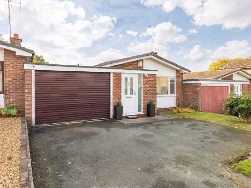 2 bedroom detached bungalow for sale in Woodnook Road, Appley Bridge, WN6 9JT, WN6 — £290,000 • 2 bed • 1 bath • 1153 ft²
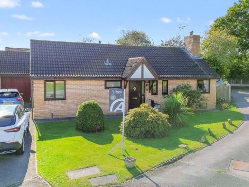 2 bedroom detached bungalow for sale in Leighton Drive, Leigh, WN7 — £270,000 • 2 bed • 2 bath • 872 ft²
 2 bedroom detached bungalow for sale in Bickershaw Lane, Abram, WN2 — £200,000 • 2 bed • 1 bath • 807 ft²
 3 bedroom semi-detached bungalow for sale in Willow Grove, Ashton-In-Makerfield, WN4 8XF, WN4 — £175,000 • 3 bed • 1 bath • 972 ft²
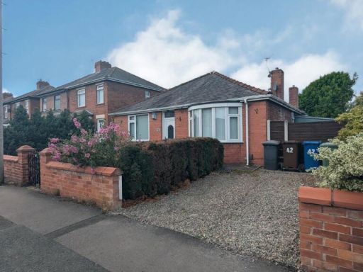 2 bedroom detached bungalow for sale in Windsor Road, Ashton-in-Makerfield, Wigan, WN4 9EQ, WN4 — £230,000 • 2 bed • 1 bath • 1000 ft²
Meta
- {
"@context": "https://schema.org",
"@type": "Residence",
"name": "2 bedroom detached bungalow for sale in Scot Lane, Aspull,…",
"description": "",
"url": "https://propertypiper.co.uk/property/8cb6169d-223d-4c00-bc83-e09ee50dddc8",
"image": "https://image-a.propertypiper.co.uk/477863d2-4896-4790-a953-113c5d27697a-1024.jpeg",
"address": {
"@type": "PostalAddress",
"streetAddress": "\n 27 Scot Lane,Aspull,WIGAN,WN2 1YX\n ",
"postalCode": "WN2 1YX",
"addressLocality": "Wigan",
"addressRegion": "Wigan",
"addressCountry": "England"
},
"geo": {
"@type": "GeoCoordinates",
"latitude": 53.5701119,
"longitude": -2.5835054
},
"numberOfRooms": 2,
"numberOfBathroomsTotal": 1,
"floorSize": {
"@type": "QuantitativeValue",
"value": 822,
"unitCode": "FTK"
},
"offers": {
"@type": "Offer",
"price": 225000,
"priceCurrency": "GBP",
"availability": "https://schema.org/InStock"
},
"additionalProperty": [
{
"@type": "PropertyValue",
"name": "Feature",
"value": "detached"
},
{
"@type": "PropertyValue",
"name": "Feature",
"value": "bungalow"
},
{
"@type": "PropertyValue",
"name": "Feature",
"value": "brick"
},
{
"@type": "PropertyValue",
"name": "Feature",
"value": "mid-20th century"
},
{
"@type": "PropertyValue",
"name": "Feature",
"value": "single-storey"
},
{
"@type": "PropertyValue",
"name": "Feature",
"value": "driveway"
},
{
"@type": "PropertyValue",
"name": "Feature",
"value": "garage"
},
{
"@type": "PropertyValue",
"name": "Feature",
"value": "garden"
},
{
"@type": "PropertyValue",
"name": "Feature",
"value": "front lawn"
},
{
"@type": "PropertyValue",
"name": "Feature",
"value": "1970s"
},
{
"@type": "PropertyValue",
"name": "Feature",
"value": "bungalow"
},
{
"@type": "PropertyValue",
"name": "Feature",
"value": "brick"
},
{
"@type": "PropertyValue",
"name": "Feature",
"value": "detached"
},
{
"@type": "PropertyValue",
"name": "Feature",
"value": "lawn"
},
{
"@type": "PropertyValue",
"name": "Feature",
"value": "small garden"
},
{
"@type": "PropertyValue",
"name": "Feature",
"value": "residential area"
}
]
}
High Res Floorplan Images
Compatible Floorplan Images
FloorplanImages Thumbnail