S73 9QS - 2 bedroom apartment for sale in Hampton Court, Darfield, Ba…
View on Property Piper
2 bedroom apartment for sale in Hampton Court, Darfield, Barnsley, S73
Property Details
- Price: £70000
- Bedrooms: 2
- Bathrooms: 2
- Property Type: undefined
- Property SubType: undefined
Brochure Descriptions
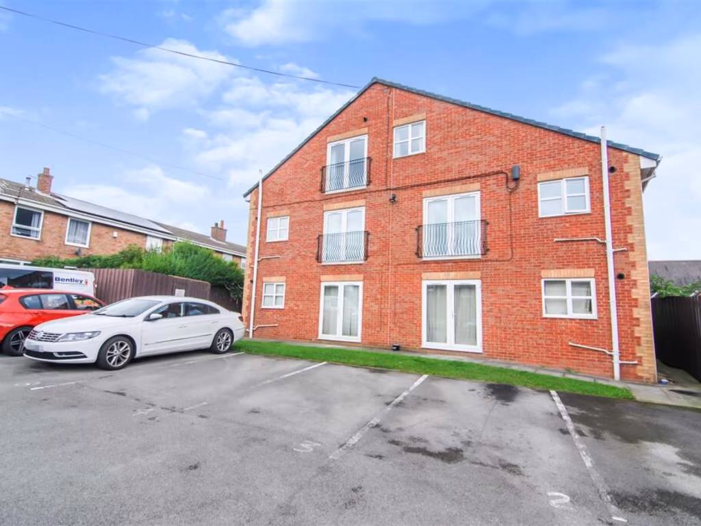
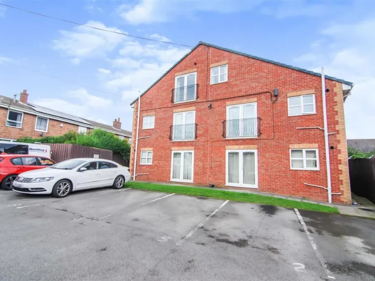
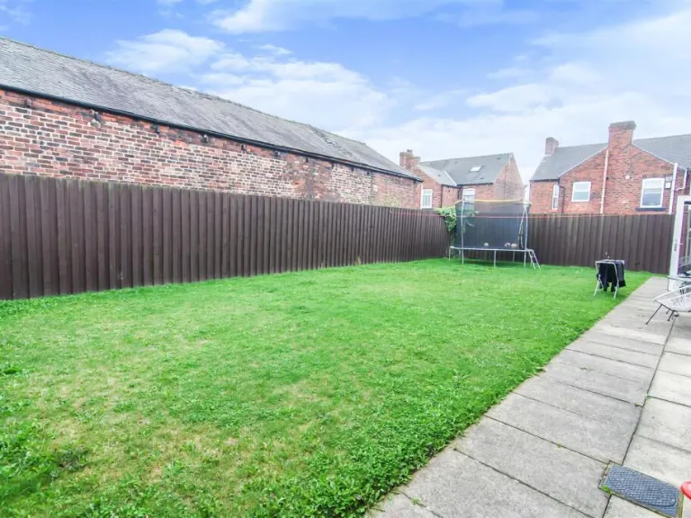
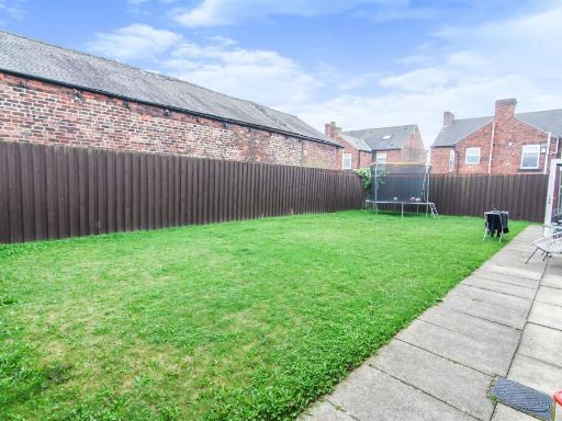
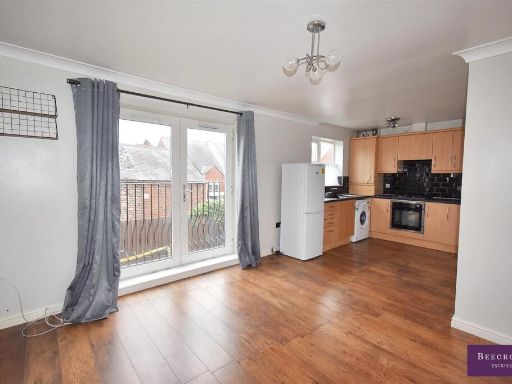
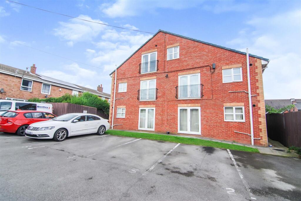
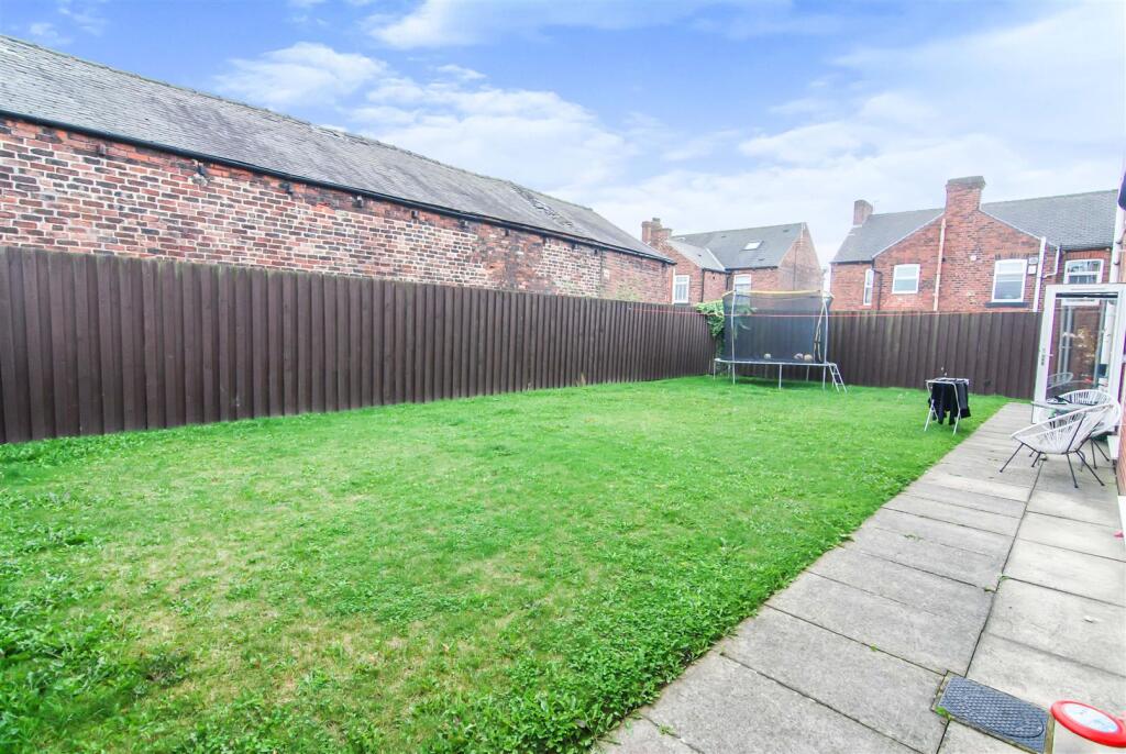
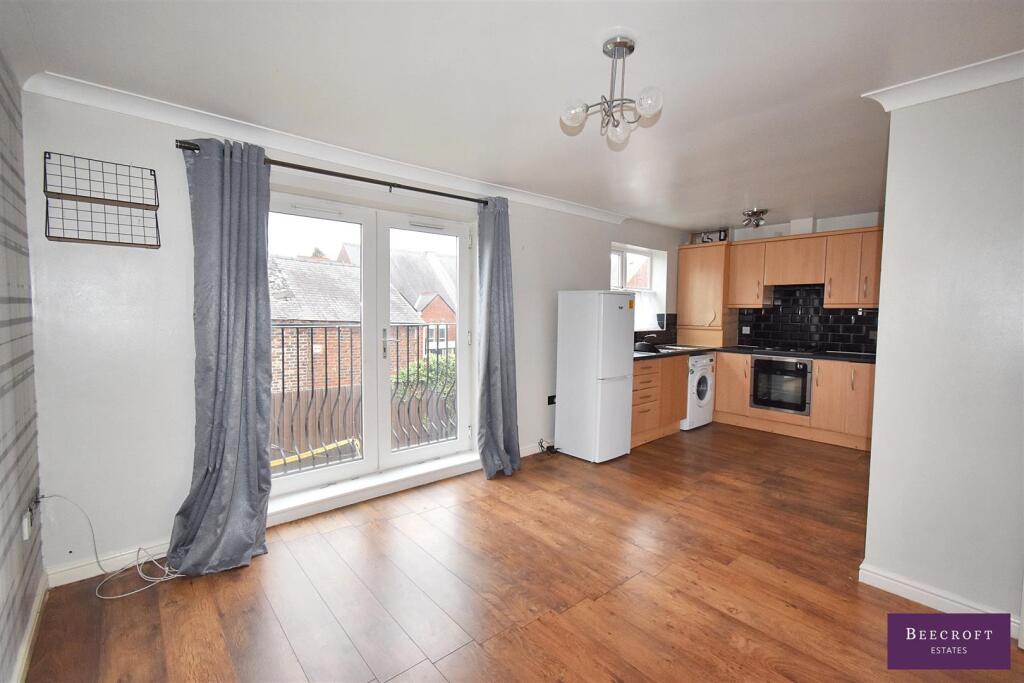
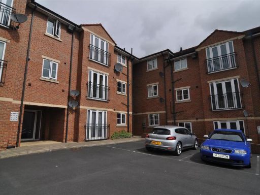
- A two-bedroom apartment within a modern brick-built block located in Darfield, Barnsley. The flat is presented as an ideal first-time purchase or buy-to-let, benefiting from a juliet balcony to the living room, a contemporary bathroom and access to a well-kept, relatively large communal/private garden. Off-street parking spaces are available directly in front of the block. Constructed in recent years (brick façade, pitched roof), the property occupies one level within a small three-storey block and offers efficient living accommodation with good natural light to the main rooms. EPC rating B. Overall plot/garden size: large for a flat setting; unit internal size not specified but typical of a two-bedroom flat (average). Potential rental income noted at approx. £525 pcm.
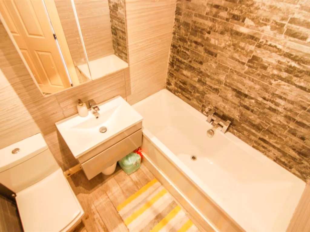
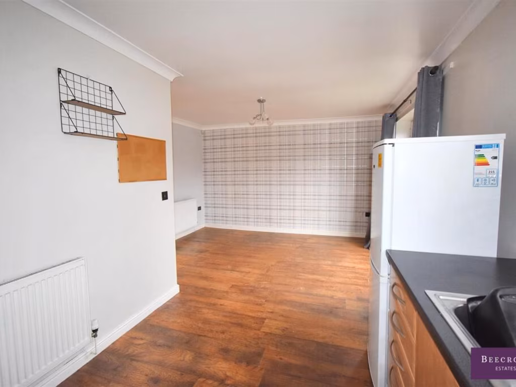
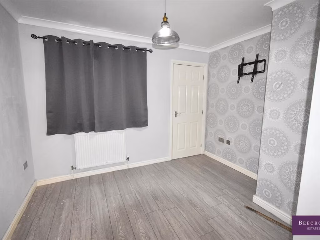
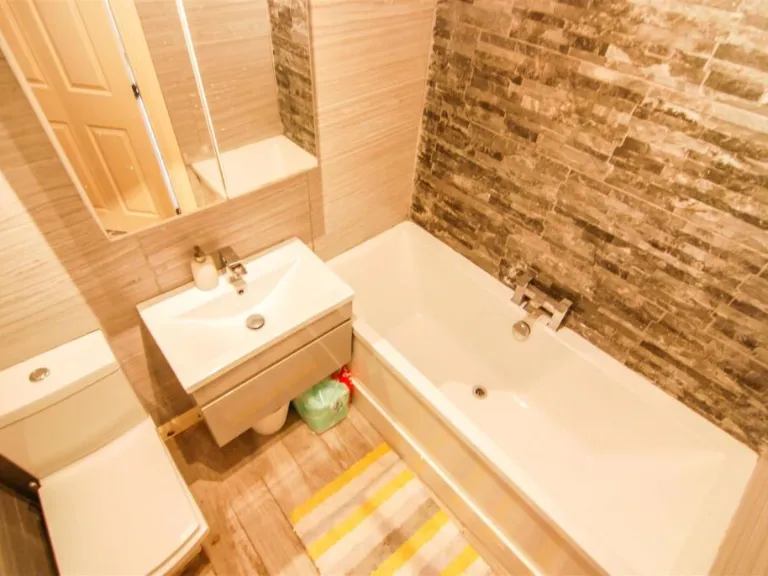
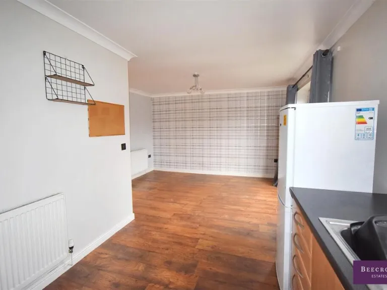
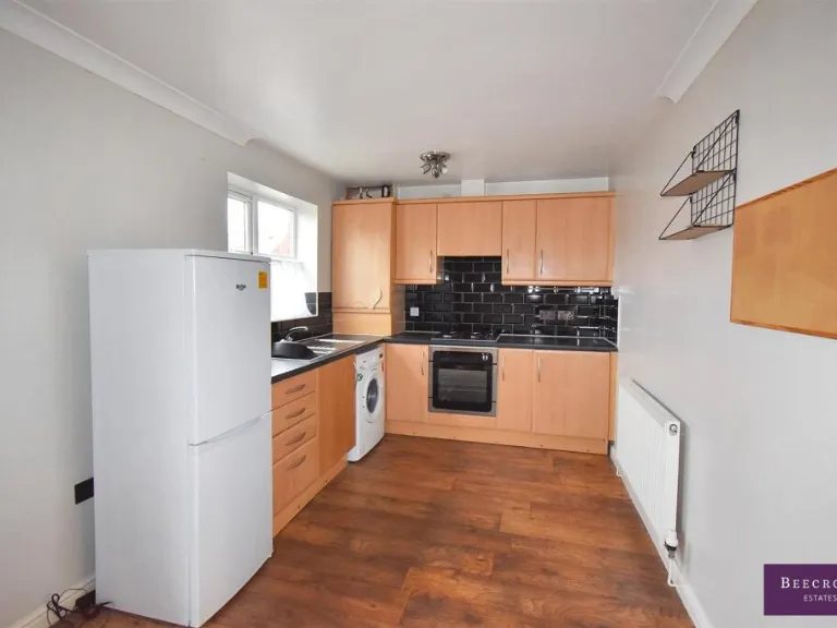
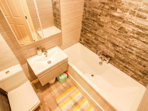
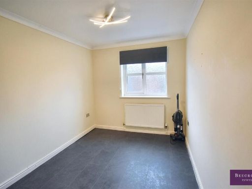
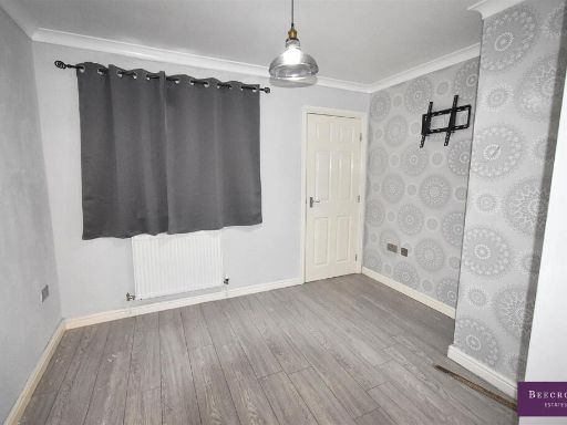
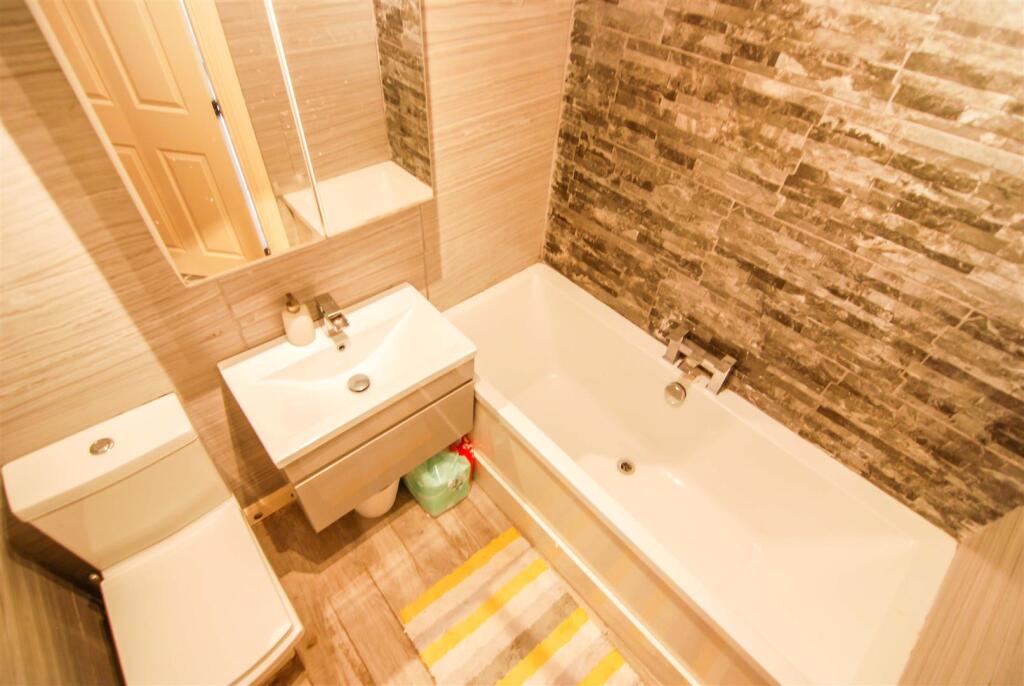
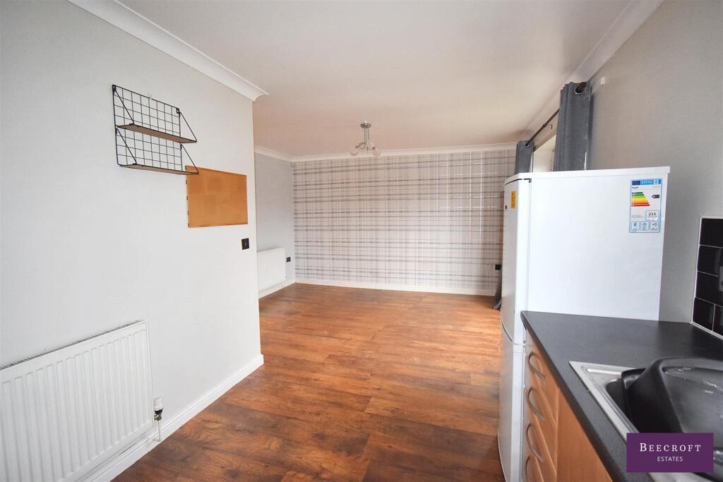
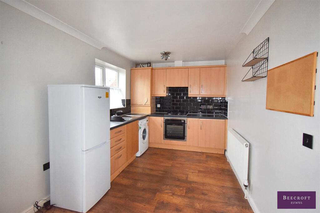
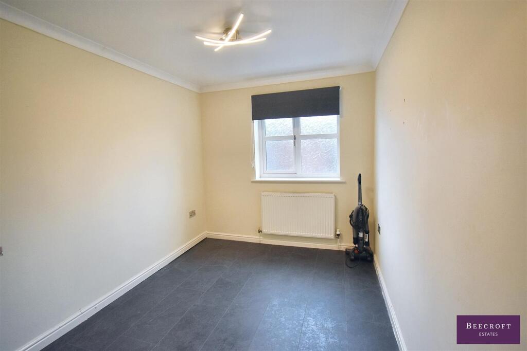
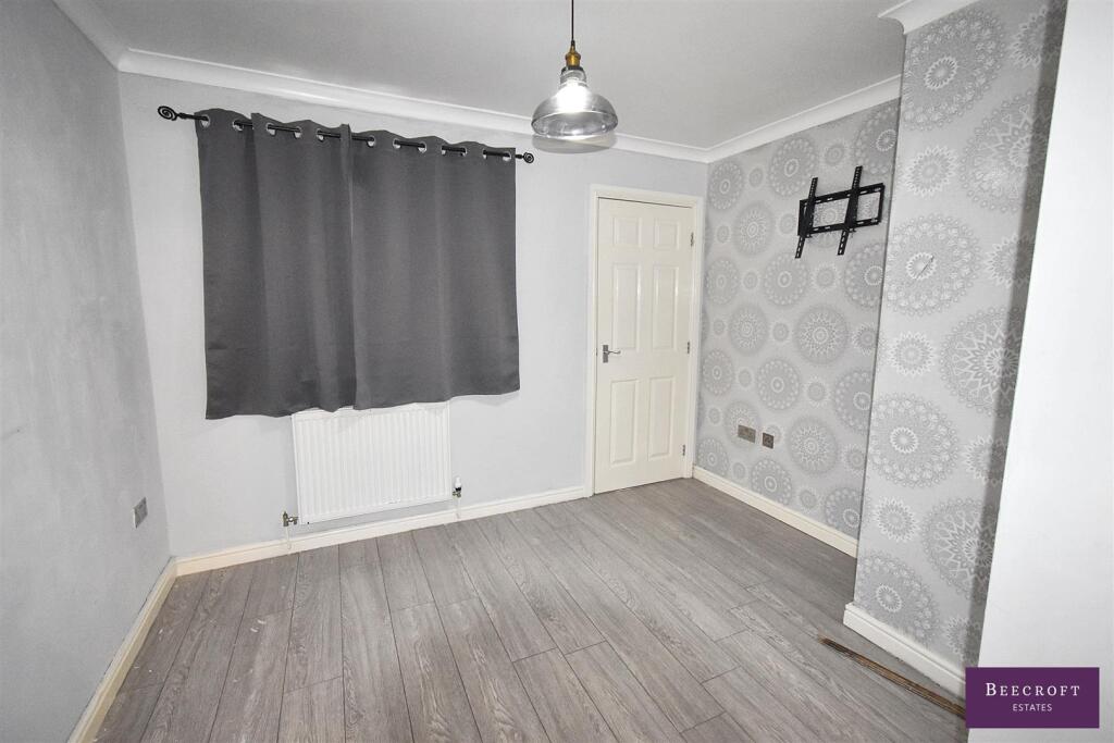
- A two-bedroom apartment presented with laminate flooring and an open-plan lounge/kitchen. The kitchen includes integrated oven, hob and extractor, sink with mixer tap, space and plumbing for a washing machine and provision for a fridge/freezer. The lounge benefits from a Juliet-style balcony. Bedroom one is a double with an en-suite; bedroom two is also a double. There is a modern three-piece bathroom (bath, WC and wash basin). Outside the property has allocated parking and communal gardens. Overall the property appears to be a modest/average-sized apartment suitable for first-time buyers or buy-to-let investors; garden space is communal and therefore small in private terms. No total floor area or full postal address for the residential property is visible on the provided image.
Image Descriptions
- apartment building contemporary
- bathroom modern
Floorplan Description
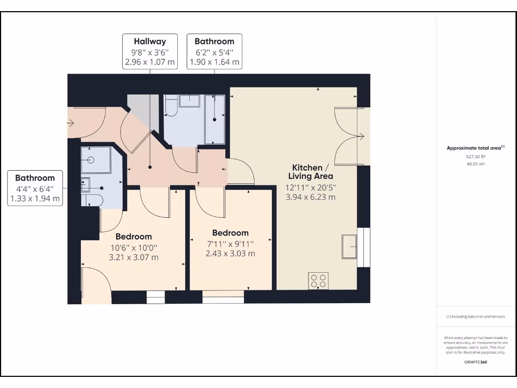
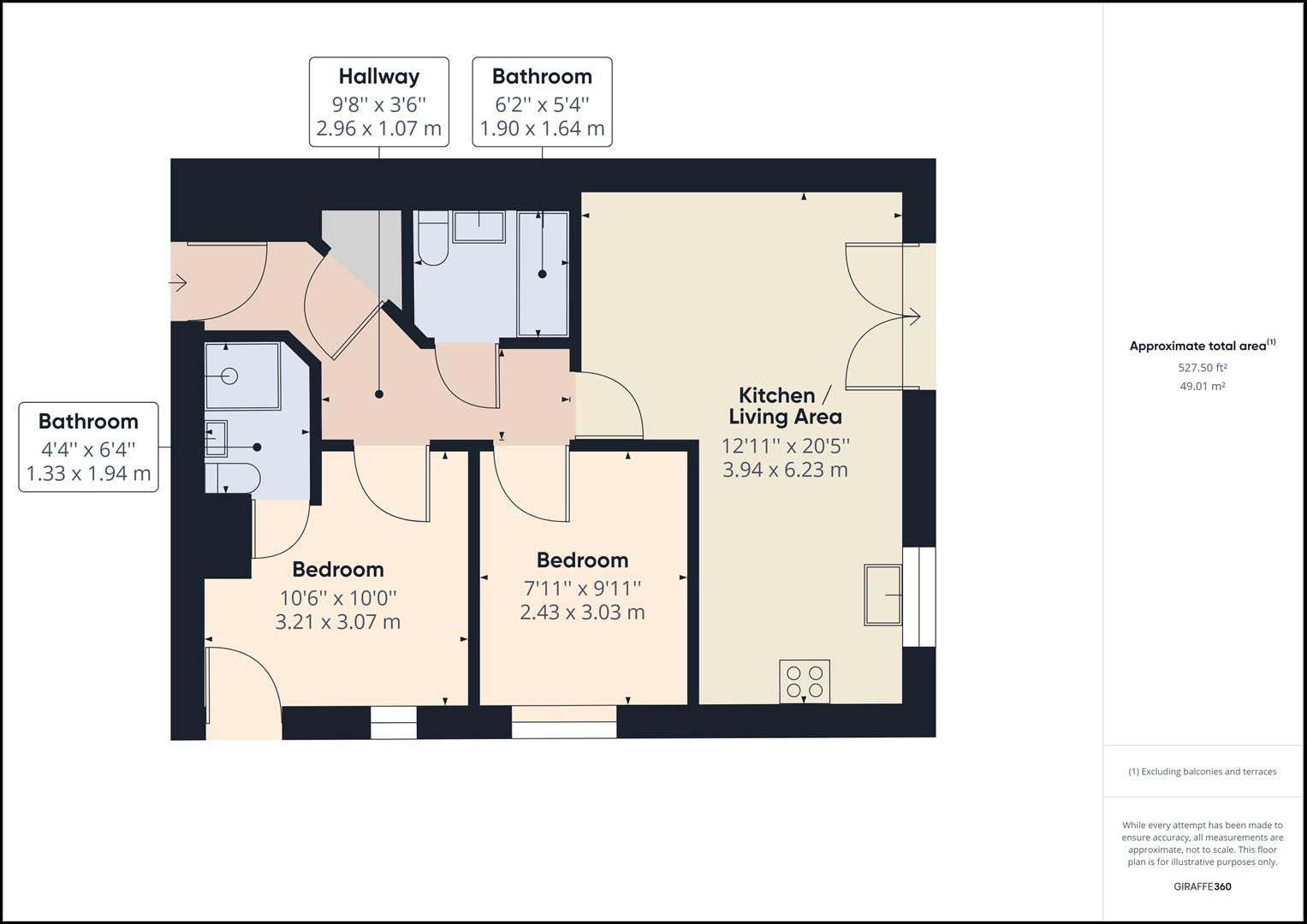
- Two-bedroom apartment with combined kitchen/living area
Rooms
- Hallway:
- Bathroom:
- Bathroom:
- Kitchen / Living Area:
- Bedroom:
- Bedroom:
Textual Property Features
- Has Garden
- Chain Free
- Success
Detected Visual Features
- modern
- brick
- apartment
- multi-story
- parking
- modern bathroom
- small bathroom
- tiled walls
- bathtub
- oversized sink
- mirror
- sink storage
- grey tiles
- contemporary design
EPC Details
- Fully double glazed
- Cavity wall, as built, insulated (assumed)
- Boiler and radiators, mains gas
- Low energy lighting in all fixed outlets
- (another dwelling below)
Nearby Schools
- Wath Central Primary School
- Kings Oak Primary Learning Centre
- St Michael and All Angels Catholic Primary School
- Sandhill Primary School
- Birkwood Primary School
- Churchfield Primary School
- Our Lady and St Joseph's Catholic Primary School
- Greenfield Primary School
- Jump Primary School
- Wombwell Park Street Primary School
- Lacewood Primary School
- Netherwood Academy
- Upperwood Academy
- Brampton Ellis CofE Primary School
- Wath Church of England Primary School
- Highfield Farm Primary School
- The Ellis Church of England (Voluntary Aided) Primary School
- High View Primary Learning Centre
- Outwood Primary Academy Darfield
- Outwood Academy Shafton
- Wath Academy
- Brampton Cortonwood Infant School
- Heather Garth Primary School Academy
- All Saints Academy Darfield
- Hunningley Primary Academy
- Oakhill Primary Academy
- Milefield Primary School
- Cherry Dale Primary School
- Elsecar Holy Trinity CofE Primary Academy
Nearest Bars And Restaurants
- Id: 8308657659
- Tags:
- Amenity: fast_food
- Brand: Greggs
- Brand:wikidata: Q3403981
- Brand:wikipedia: en:Greggs
- Contact:
- Website: https://www.greggs.co.uk/shop-finder?shop-code=0341
- Cuisine: sandwich;bakery
- Name: Greggs
- Takeaway: yes
- TagsNormalized:
- fast food
- food
- greggs
- sandwich
- bakery
- takeaway
- Lat: 53.523447
- Lon: -1.3997148
- FullGeoHash: gcx02psu8m8v
- PartitionGeoHash: gcx0
- Images:
- FoodStandards: null
- Distance: 1334.3
,- Id: 5666383072
- Tags:
- TagsNormalized:
- Lat: 53.5241045
- Lon: -1.4006587
- FullGeoHash: gcx02pu0d21p
- PartitionGeoHash: gcx0
- Images:
- FoodStandards: null
- Distance: 1327.6
,- Id: 1045717725
- Tags:
- Addr:
- Housenumber: 18
- Postcode: S73 9HH
- Street: Doncaster Road
- Amenity: restaurant
- Cuisine: indian
- Name: Thaal
- TagsNormalized:
- Lat: 53.5361185
- Lon: -1.3683184
- FullGeoHash: gcx08cgw7zgf
- PartitionGeoHash: gcx0
- Images:
- FoodStandards: null
- Distance: 1238.3
,- Id: 2261994195
- Tags:
- Amenity: pub
- Name: Cross Keys
- TagsNormalized:
- Lat: 53.5334558
- Lon: -1.3709813
- FullGeoHash: gcx08c3wvz6n
- PartitionGeoHash: gcx0
- Images:
- FoodStandards: null
- Distance: 991.9
,- Id: 2238132172
- Tags:
- Amenity: fast_food
- Cuisine: fish
- Name: Morrison Road Chippy
- Source: arturo888
- TagsNormalized:
- Lat: 53.5379664
- Lon: -1.3821523
- FullGeoHash: gcx08d393829
- PartitionGeoHash: gcx0
- Images:
- FoodStandards: null
- Distance: 690.1
}
Nearest General Shops
- Id: 777288903
- Tags:
- Addr:
- City: Wombwell
- Housenumber: 60
- Postcode: S73 8DA
- Street: High Street
- Brand: Heron Foods
- Brand:wikidata: Q5743472
- Brand:wikipedia: en:Heron Foods
- Building: yes
- Contact:
- Website: https://heronfoods.com/store/wombwell/
- Fhrs:
- Name: Heron Foods
- Shop: supermarket
- TagsNormalized:
- Lat: 53.5238438
- Lon: -1.4000792
- FullGeoHash: gcx02psqzz9k
- PartitionGeoHash: gcx0
- Images:
- FoodStandards:
- Id: 398794
- FHRSID: 398794
- LocalAuthorityBusinessID: 85943
- BusinessName: Heron Foods Ltd
- BusinessType: Retailers - other
- BusinessTypeID: 4613
- AddressLine1: null
- AddressLine2: 60 High Street
- AddressLine3: null
- AddressLine4: Wombwell
- PostCode: S73 8DA
- RatingValue: 5
- RatingKey: fhrs_5_en-GB
- RatingDate: 2018-11-30
- LocalAuthorityCode: 401
- LocalAuthorityName: Barnsley
- LocalAuthorityWebSite: http://www.barnsley.gov.uk
- LocalAuthorityEmailAddress: food@barnsley.gov.uk
- Scores:
- Hygiene: 0
- Structural: 0
- ConfidenceInManagement: 0
- NewRatingPending: false
- Geocode:
- Longitude: -1.40042900000000
- Latitude: 53.52403500000000
- Distance: 1319.7
,- Id: 298304734
- Tags:
- TagsNormalized:
- Lat: 53.541864
- Lon: -1.3903405
- FullGeoHash: gcx086gxfwyg
- PartitionGeoHash: gcx0
- Images:
- FoodStandards: null
- Distance: 1119.6
,- Id: 2238121660
- Tags:
- Name: Whites Bakery
- Shop: bakery
- Source: arturo888
- TagsNormalized:
- Lat: 53.5339222
- Lon: -1.3757633
- FullGeoHash: gcx089w1wqks
- PartitionGeoHash: gcx0
- Images:
- FoodStandards: null
- Distance: 693.7
}
Nearest Grocery shops
- Id: 945187262
- Tags:
- Brand: Tesco Express
- Brand:wikidata: Q98456772
- Contact:
- Website: https://www.tesco.com/store-locator/wombwell/62-high-st
- Name: Tesco Express
- Shop: convenience
- TagsNormalized:
- tesco
- tesco express
- convenience
- shop
- Lat: 53.5238917
- Lon: -1.4003466
- FullGeoHash: gcx02psr389f
- PartitionGeoHash: gcx0
- Images:
- FoodStandards: null
- Distance: 1328.7
,- Id: 3257106796
- Tags:
- Addr:
- City: Darfield
- Country: GB
- Postcode: S73 9DJ
- Street: Barnsley Road
- Brand: The Co-operative Food
- Brand:wikidata: Q107617274
- Fhrs:
- Name: The Co-operative Food
- Operator: The Co-operative Group
- Shop: supermarket
- TagsNormalized:
- the co-operative food
- food
- shop
- Lat: 53.5375797
- Lon: -1.3864119
- FullGeoHash: gcx086nrn20q
- PartitionGeoHash: gcx0
- Images:
- FoodStandards:
- Id: 397277
- FHRSID: 397277
- LocalAuthorityBusinessID: 1049
- BusinessName: Co-operative
- BusinessType: Retailers - supermarkets/hypermarkets
- BusinessTypeID: 7840
- AddressLine1: The Cooperative
- AddressLine2: Barnsley Road
- AddressLine3: null
- AddressLine4: Darfield
- PostCode: S73 9DJ
- RatingValue: 5
- RatingKey: fhrs_5_en-GB
- RatingDate: 2015-05-20
- LocalAuthorityCode: 401
- LocalAuthorityName: Barnsley
- LocalAuthorityWebSite: http://www.barnsley.gov.uk
- LocalAuthorityEmailAddress: food@barnsley.gov.uk
- Scores:
- Hygiene: 0
- Structural: 0
- ConfidenceInManagement: 0
- NewRatingPending: false
- Geocode:
- Longitude: -1.38638600000000
- Latitude: 53.53759900000000
- Distance: 604.1
,- Id: 7282633387
- Tags:
- Brand: One Stop
- Brand:wikidata: Q65954217
- Name: One Stop
- Shop: convenience
- TagsNormalized:
- Lat: 53.5319963
- Lon: -1.3832197
- FullGeoHash: gcx0890y2xks
- PartitionGeoHash: gcx0
- Images:
- FoodStandards: null
- Distance: 173.5
}
Nearest Supermarkets
- Id: 151251603
- Tags:
- Addr:
- Brand: Morrisons
- Brand:wikidata: Q922344
- Brand:wikipedia: en:Morrisons
- Building: yes
- Contact:
- Website: https://my.morrisons.com/storefinder/112
- Name: Morrisons
- Shop: supermarket
- TagsNormalized:
- Lat: 53.5074214
- Lon: -1.3906491
- FullGeoHash: gcx02ker7d2c
- PartitionGeoHash: gcx0
- Images:
- FoodStandards: null
- Distance: 2769
,- Id: 802273073
- Tags:
- Brand: M&S Foodhall
- Brand:wikidata: Q714491
- Brand:wikipedia: en:Marks & Spencer
- Building: yes
- Contact:
- Website: https://www.marksandspencer.com/stores/barnsley-cortonwood-foodhall-2114
- Name: M&S Foodhall
- Shop: supermarket
- TagsNormalized:
- m&s foodhall
- supermarket
- shop
- Lat: 53.5090052
- Lon: -1.385342
- FullGeoHash: gcx02mp0x1w1
- PartitionGeoHash: gcx0
- Images:
- FoodStandards: null
- Distance: 2574.7
,- Id: 852636148
- Tags:
- Addr:
- City: Barnsley
- Postcode: S73 8DS
- Street: Bradbury Balk Lane
- Town: Wombwell
- Brand: Lidl
- Brand:wikidata: Q151954
- Brand:wikipedia: en:Lidl
- Building: yes
- Fhrs:
- Name: Lidl
- Not:
- Note: FHRS Open Data has the postcode as S73 8JN but Code Point Open and Geolytix Open Data suggest S73 8DS
- Shop: supermarket
- TagsNormalized:
- Lat: 53.5296904
- Lon: -1.4077946
- FullGeoHash: gcwbxbych183
- PartitionGeoHash: gcwb
- Images:
- FoodStandards:
- Id: 928285
- FHRSID: 928285
- LocalAuthorityBusinessID: 160523
- BusinessName: Lidl
- BusinessType: Retailers - supermarkets/hypermarkets
- BusinessTypeID: 7840
- AddressLine1: Lidl
- AddressLine2: Bradbury Balk Lane
- AddressLine3: null
- AddressLine4: Wombwell
- PostCode: S73 8JN
- RatingValue: 5
- RatingKey: fhrs_5_en-GB
- RatingDate: 2017-09-07
- LocalAuthorityCode: 401
- LocalAuthorityName: Barnsley
- LocalAuthorityWebSite: http://www.barnsley.gov.uk
- LocalAuthorityEmailAddress: food@barnsley.gov.uk
- Scores:
- Hygiene: 5
- Structural: 0
- ConfidenceInManagement: 5
- NewRatingPending: false
- Geocode:
- Longitude: null
- Latitude: null
- Distance: 1477.4
}
Nearest Religious buildings
- Id: 779920295
- Tags:
- Amenity: community_centre
- Building: yes
- Name: Darfield Church Hall
- TagsNormalized:
- community centre
- church
- church hall
- Lat: 53.5333033
- Lon: -1.3703706
- FullGeoHash: gcx08c6nh518
- PartitionGeoHash: gcx0
- Images:
- FoodStandards: null
- Distance: 1029.7
,- Id: 400848556
- Tags:
- Leisure: pitch
- Name: Darfield/Church Street Crown Green Bowls Club
- Sport: bowls
- TagsNormalized:
- pitch
- leisure
- bowls
- church
- club
- sports
- Lat: 53.5340293
- Lon: -1.3733501
- FullGeoHash: gcx089xfqd7g
- PartitionGeoHash: gcx0
- Images:
- FoodStandards: null
- Distance: 850.7
,- Id: 2261995182
- Tags:
- Amenity: place_of_worship
- Name: Methodist Church
- Religion: christian
- TagsNormalized:
- place of worship
- church
- methodist
- christian
- Lat: 53.5345156
- Lon: -1.3760388
- FullGeoHash: gcx089tvpvp0
- PartitionGeoHash: gcx0
- Images:
- FoodStandards: null
- Distance: 698.2
}
Nearest Medical buildings
- Id: 7282633404
- Tags:
- Amenity: pharmacy
- Dispensing: yes
- Healthcare: pharmacy
- Name: Rowlands
- TagsNormalized:
- Lat: 53.5216367
- Lon: -1.3960096
- FullGeoHash: gcx02pr6ns5y
- PartitionGeoHash: gcx0
- Images:
- FoodStandards: null
- Distance: 1349.6
,- Id: 779920303
- Tags:
- Amenity: pharmacy
- Building: yes
- Dispensing: yes
- Healthcare: pharmacy
- Name: Stone
- TagsNormalized:
- Lat: 53.5341969
- Lon: -1.3728914
- FullGeoHash: gcx08c87339g
- PartitionGeoHash: gcx0
- Images:
- FoodStandards: null
- Distance: 884.7
,- Id: 779920302
- Tags:
- Amenity: doctors
- Healthcare: doctor
- Name: Garland House Surgery
- TagsNormalized:
- doctor
- doctors
- health
- healthcare
- surgery
- Lat: 53.5339864
- Lon: -1.372907
- FullGeoHash: gcx08c860fq7
- PartitionGeoHash: gcx0
- Images:
- FoodStandards: null
- Distance: 878
,- Id: 2238121667
- Tags:
- Amenity: pharmacy
- Brand: Well Pharmacy
- Brand:wikidata: Q7726524
- Healthcare: pharmacy
- Name: Well Pharmacy
- TagsNormalized:
- pharmacy
- well pharmacy
- health
- healthcare
- Lat: 53.5337734
- Lon: -1.3738519
- FullGeoHash: gcx089x8fftv
- PartitionGeoHash: gcx0
- Images:
- FoodStandards: null
- Distance: 811.8
}
Nearest Airports
- Id: 100889514
- Tags:
- Addr:
- Aerodrome: international
- Aerodrome:type: public
- Area: yes
- Cities_served: Doncaster, Sheffield
- Closest_town: Doncaster
- Disused:
- Ele: 17
- Iata: DSA
- Icao: EGCN
- Ifr: yes
- Is_in: Finningley
- Name: Doncaster Sheffield Airport
- Old_iata: FNY
- Old_icao: EGXI
- Old_name: RAF Finningley
- Old_operator: Royal Air Force
- Old_type: military
- Operator: Doncaster Sheffield Airport Limited/Peel Airports
- Source: wikipedia
- Tower_frequency: 128.775
- Vfr: yes
- Website: https://www.robinhoodairport.com/
- Wikidata: Q8996
- Wikipedia: en:Robin Hood Airport Doncaster Sheffield
- TagsNormalized:
- airport
- international airport
- Lat: 53.4761577
- Lon: -1.0054086
- FullGeoHash: gcx21p5chq34
- PartitionGeoHash: gcx2
- Images:
- FoodStandards: null
- Distance: 25918.2
}
Nearest Leisure Facilities
- Id: 4033507657
- Tags:
- TagsNormalized:
- Lat: 53.5262705
- Lon: -1.3881349
- FullGeoHash: gcx082jjnh58
- PartitionGeoHash: gcx0
- Images:
- FoodStandards: null
- Distance: 672.2
,- Id: 774979783
- Tags:
- Leisure: pitch
- Sport: soccer
- TagsNormalized:
- Lat: 53.5313089
- Lon: -1.3955781
- FullGeoHash: gcx081pf2xjx
- PartitionGeoHash: gcx0
- Images:
- FoodStandards: null
- Distance: 651.1
,- Id: 298308158
- Tags:
- TagsNormalized:
- Lat: 53.5284246
- Lon: -1.3849858
- FullGeoHash: gcx082x3xmxd
- PartitionGeoHash: gcx0
- Images:
- FoodStandards: null
- Distance: 418.9
,- Id: 298304891
- Tags:
- TagsNormalized:
- Lat: 53.5354484
- Lon: -1.386112
- FullGeoHash: gcx083ydt4zu
- PartitionGeoHash: gcx0
- Images:
- FoodStandards: null
- Distance: 366.3
,- Id: 298305917
- Tags:
- TagsNormalized:
- Lat: 53.5310504
- Lon: -1.3895438
- FullGeoHash: gcx083h0vr11
- PartitionGeoHash: gcx0
- Images:
- FoodStandards: null
- Distance: 274.6
}
Nearest Tourist attractions
- Id: 968462884
- Tags:
- Area: yes
- Name: Monk Bretton Priory
- Operator: English Heritage
- Tourism: attraction
- Website: https://www.english-heritage.org.uk/visit/places/monk-bretton-priory/
- TagsNormalized:
- Lat: 53.553979
- Lon: -1.4379091
- FullGeoHash: gcwbxm0yw332
- PartitionGeoHash: gcwb
- Images:
- FoodStandards: null
- Distance: 4210.5
,- Id: 137377383
- Tags:
- Amenity: cafe
- Building: yes
- Name: Old Moor Visitor Centre
- Operator: RSPB
- Toilets:
- Tourism: information
- Wheelchair: yes
- TagsNormalized:
- Lat: 53.5154459
- Lon: -1.3648235
- FullGeoHash: gcx02ynnj61v
- PartitionGeoHash: gcx0
- Images:
- FoodStandards: null
- Distance: 2319.8
,- Id: 779920298
- Tags:
- Building: yes
- Name: Maurice Dobson Museum
- Tourism: museum
- Wikidata: Q41663027
- TagsNormalized:
- Lat: 53.53367
- Lon: -1.3714065
- FullGeoHash: gcx08c925zmh
- PartitionGeoHash: gcx0
- Images:
- FoodStandards: null
- Distance: 968
}
Nearest Train stations
- Id: 254510740
- Tags:
- Name: Barnsley Interchange
- Naptan:
- Network: National Rail
- Platforms: 2
- Public_transport: station
- Railway: station
- Ref:
- Wikidata: Q2711384
- Wikipedia: en:Barnsley Interchange
- TagsNormalized:
- Lat: 53.5544108
- Lon: -1.4772984
- FullGeoHash: gcwbwmk303y2
- PartitionGeoHash: gcwb
- Images:
- FoodStandards: null
- Distance: 6530.5
,- Id: 7452565687
- Tags:
- Name: Thurnscoe
- Naptan:
- Network: National Rail
- Public_transport: station
- Railway: station
- Ref:
- Wikidata: Q2012147
- Wikipedia: en:Thurnscoe railway station
- TagsNormalized:
- Lat: 53.5455375
- Lon: -1.3083856
- FullGeoHash: gcx0d5xm27su
- PartitionGeoHash: gcx0
- Images:
- FoodStandards: null
- Distance: 5329.5
,- Id: 7452565685
- Tags:
- Name: Bolton-upon-Dearne
- Naptan:
- Network: National Rail
- Public_transport: station
- Railway: station
- Ref:
- Source: NPE
- Wikidata: Q2001245
- Wikipedia: en:Bolton-upon-Dearne railway station
- TagsNormalized:
- Lat: 53.5188149
- Lon: -1.3114857
- FullGeoHash: gcx06nv18njq
- PartitionGeoHash: gcx0
- Images:
- FoodStandards: null
- Distance: 5133.4
,- Id: 7452565686
- Tags:
- Name: Goldthorpe
- Naptan:
- Network: National Rail
- Public_transport: station
- Railway: station
- Ref:
- Wikidata: Q2537483
- Wikipedia: en:Goldthorpe railway station
- TagsNormalized:
- Lat: 53.5338284
- Lon: -1.3128969
- FullGeoHash: gcx0d1ecpkcj
- PartitionGeoHash: gcx0
- Images:
- FoodStandards: null
- Distance: 4823.7
,- Id: 1477345762
- Tags:
- Heritage: 2
- Heritage:operator: Elsecar Heritage Railway Ltd
- Name: Rockingham
- Public_transport: station
- Railway: station
- Usage: tourism
- Wikidata: Q7355379
- Wikipedia: en:Rockingham railway station (South Yorkshire)
- TagsNormalized:
- Lat: 53.4937958
- Lon: -1.4192072
- FullGeoHash: gcwbrdnxfn63
- PartitionGeoHash: gcwb
- Images:
- FoodStandards: null
- Distance: 4802.8
}
Nearest Hotels
- Id: 323911178
- Tags:
- Amenity: pub
- Building: yes
- Demolished: building
- Name: Black Bull Hotel
- Pub: disused
- Source: survey
- Survey:
- TagsNormalized:
- Lat: 53.5456946
- Lon: -1.4390957
- FullGeoHash: gcwbx78n68um
- PartitionGeoHash: gcwb
- Images:
- FoodStandards: null
- Distance: 3828.1
,- Id: 429961858
- Tags:
- Brand: Holiday Inn Express
- Brand:wikidata: Q5880423
- Building: hotel
- Name: Holiday Inn Express Rotherham North
- Operator: Holiday Inn Express
- Tourism: hotel
- TagsNormalized:
- Lat: 53.5089612
- Lon: -1.3520224
- FullGeoHash: gcx03jp2r974
- PartitionGeoHash: gcx0
- Images:
- FoodStandards: null
- Distance: 3413
,- Id: 1063986475
- Tags:
- Addr:
- Brand: Premier Inn
- Brand:wikidata: Q2108626
- Name: Premier Inn Barnsley
- Tourism: hotel
- TagsNormalized:
- Lat: 53.5160937
- Lon: -1.3776848
- FullGeoHash: gcx02wkccdgv
- PartitionGeoHash: gcx0
- Images:
- FoodStandards: null
- Distance: 1865.7
}
Tags
- modern
- brick
- apartment
- multi-story
- parking
- modern bathroom
- small bathroom
- tiled walls
- bathtub
- oversized sink
- mirror
- sink storage
- grey tiles
- contemporary design
Local Market Stats
- Average Price/sqft: £161
- Avg Income: £34200
- Rental Yield: 4.6%
- Social Housing: 16%
- Planning Success Rate: 91%
Similar Properties
 2 bedroom apartment for sale in Langdale Court, Barnsley, S71 — £90,000 • 2 bed • 2 bath • 664 ft²
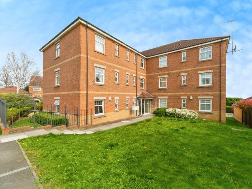 2 bedroom apartment for sale in Birchin Bank, Barnsley, S74 — £100,000 • 2 bed • 2 bath • 754 ft²
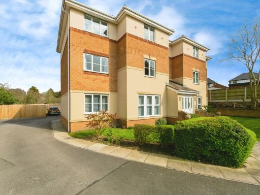 2 bedroom flat for sale in Stoney Croft, Hoyland, Barnsley, South Yorkshire, S74 — £90,000 • 2 bed • 1 bath • 520 ft²
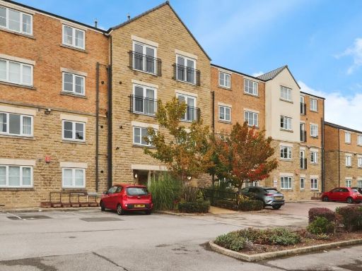 2 bedroom flat for sale in Richmond Way, Rotherham, South Yorkshire, S61 — £120,000 • 2 bed • 1 bath • 667 ft²
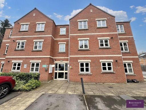 2 bedroom apartment for sale in Grange Court, Wombwell, Barnsley, S73 — £89,500 • 2 bed • 2 bath • 636 ft²
 2 bedroom flat for sale in Beever Lane, Barnsley, S75 — £115,000 • 2 bed • 2 bath
Meta
- {
"@context": "https://schema.org",
"@type": "Residence",
"name": "2 bedroom apartment for sale in Hampton Court, Darfield, Ba…",
"description": "",
"url": "https://propertypiper.co.uk/property/8c2ce0c3-b29f-440d-a502-83b4c498e635",
"image": "https://image-a.propertypiper.co.uk/48a09b59-a98e-41f7-a201-6e80c16341f4-1024.jpeg",
"address": {
"@type": "PostalAddress",
"streetAddress": "6, Hampton Court, Darfield, BARNSLEY",
"postalCode": "S73 9QS",
"addressLocality": "Barnsley",
"addressRegion": "Barnsley East",
"addressCountry": "England"
},
"geo": {
"@type": "GeoCoordinates",
"latitude": 53.53215806054689,
"longitude": -1.385830567584155
},
"numberOfRooms": 2,
"numberOfBathroomsTotal": 2,
"floorSize": {
"@type": "QuantitativeValue",
"value": 527,
"unitCode": "FTK"
},
"offers": {
"@type": "Offer",
"price": 70000,
"priceCurrency": "GBP",
"availability": "https://schema.org/InStock"
},
"additionalProperty": [
{
"@type": "PropertyValue",
"name": "Feature",
"value": "modern"
},
{
"@type": "PropertyValue",
"name": "Feature",
"value": "brick"
},
{
"@type": "PropertyValue",
"name": "Feature",
"value": "apartment"
},
{
"@type": "PropertyValue",
"name": "Feature",
"value": "multi-story"
},
{
"@type": "PropertyValue",
"name": "Feature",
"value": "parking"
},
{
"@type": "PropertyValue",
"name": "Feature",
"value": "modern bathroom"
},
{
"@type": "PropertyValue",
"name": "Feature",
"value": "small bathroom"
},
{
"@type": "PropertyValue",
"name": "Feature",
"value": "tiled walls"
},
{
"@type": "PropertyValue",
"name": "Feature",
"value": "bathtub"
},
{
"@type": "PropertyValue",
"name": "Feature",
"value": "oversized sink"
},
{
"@type": "PropertyValue",
"name": "Feature",
"value": "mirror"
},
{
"@type": "PropertyValue",
"name": "Feature",
"value": "sink storage"
},
{
"@type": "PropertyValue",
"name": "Feature",
"value": "grey tiles"
},
{
"@type": "PropertyValue",
"name": "Feature",
"value": "contemporary design"
}
]
}
High Res Floorplan Images
Compatible Floorplan Images
FloorplanImages Thumbnail