HD4 6RB - 3 bedroom detached bungalow for sale in Jackroyd Lane, Hudd…
View on Property Piper
3 bedroom detached bungalow for sale in Jackroyd Lane, Huddersfield, HD4
Property Details
- Price: £300000
- Bedrooms: 3
- Bathrooms: 1
- Property Type: undefined
- Property SubType: undefined
Brochure Descriptions
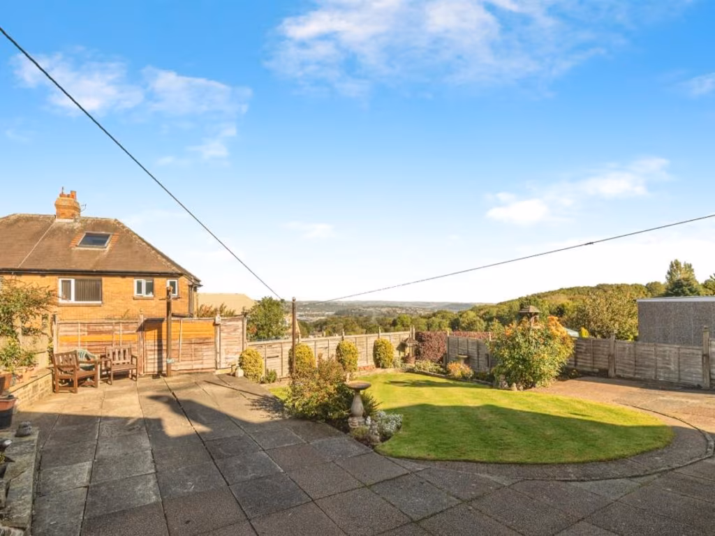
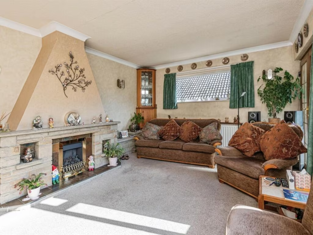
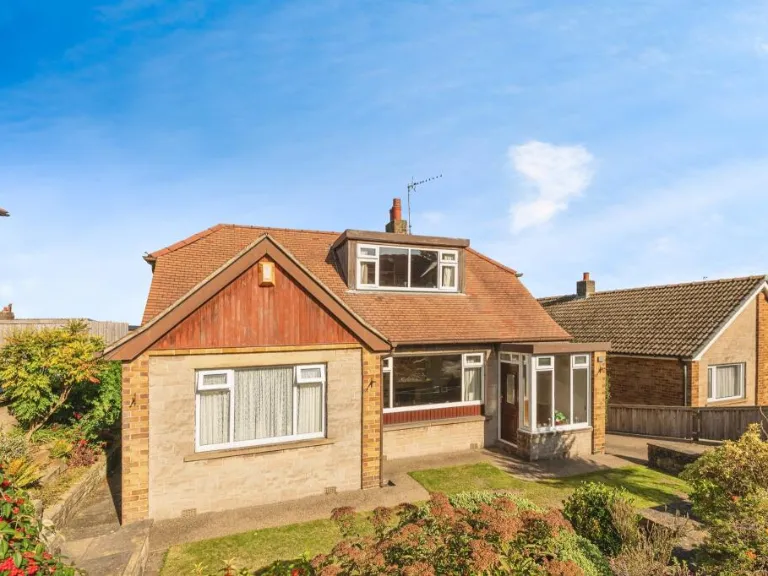
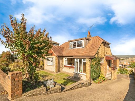
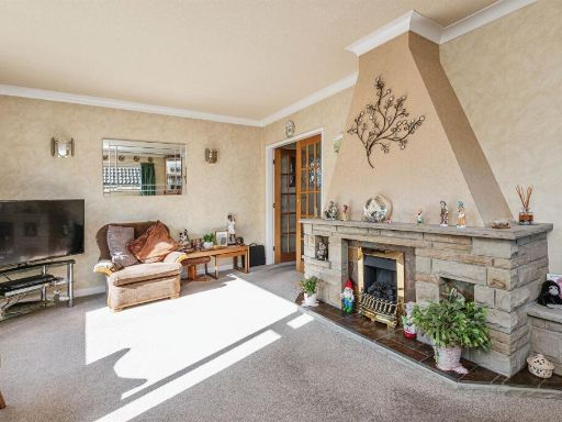
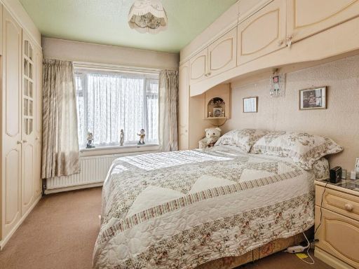
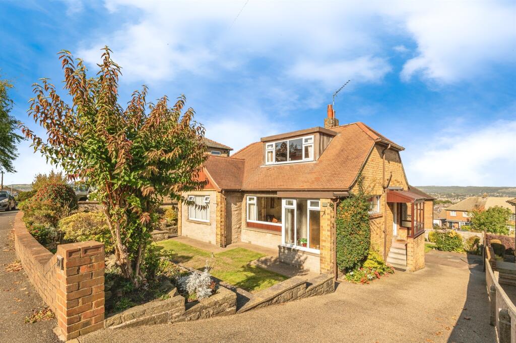
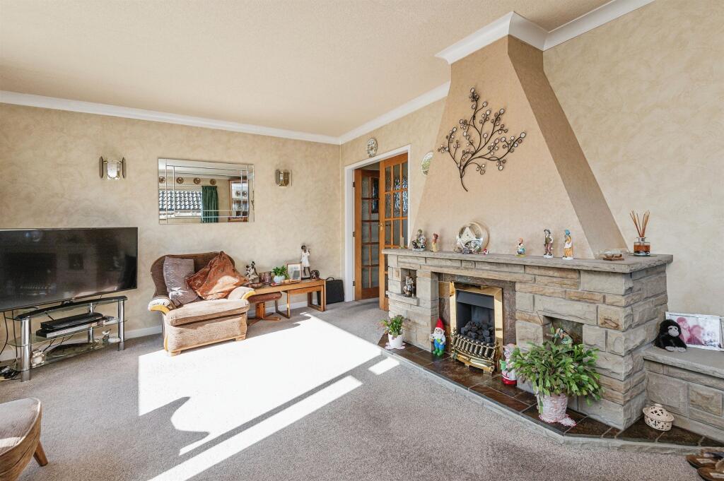
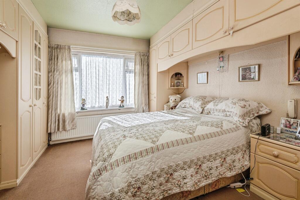
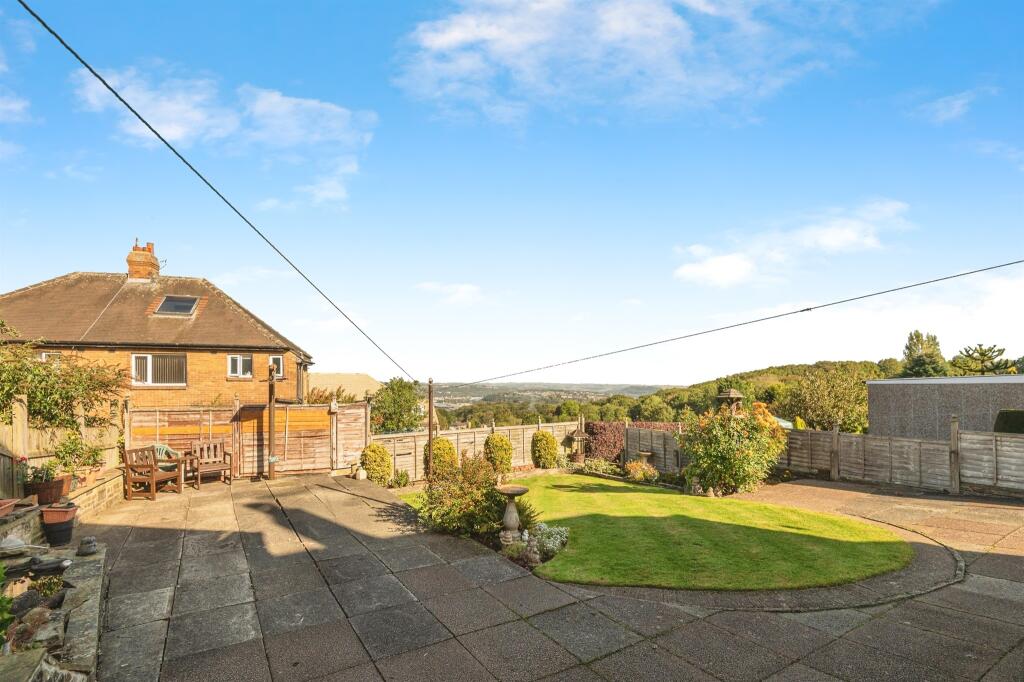
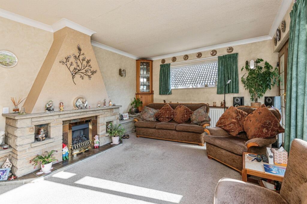
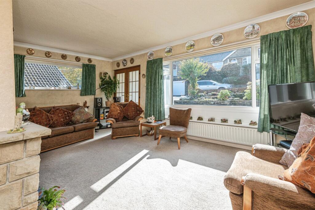
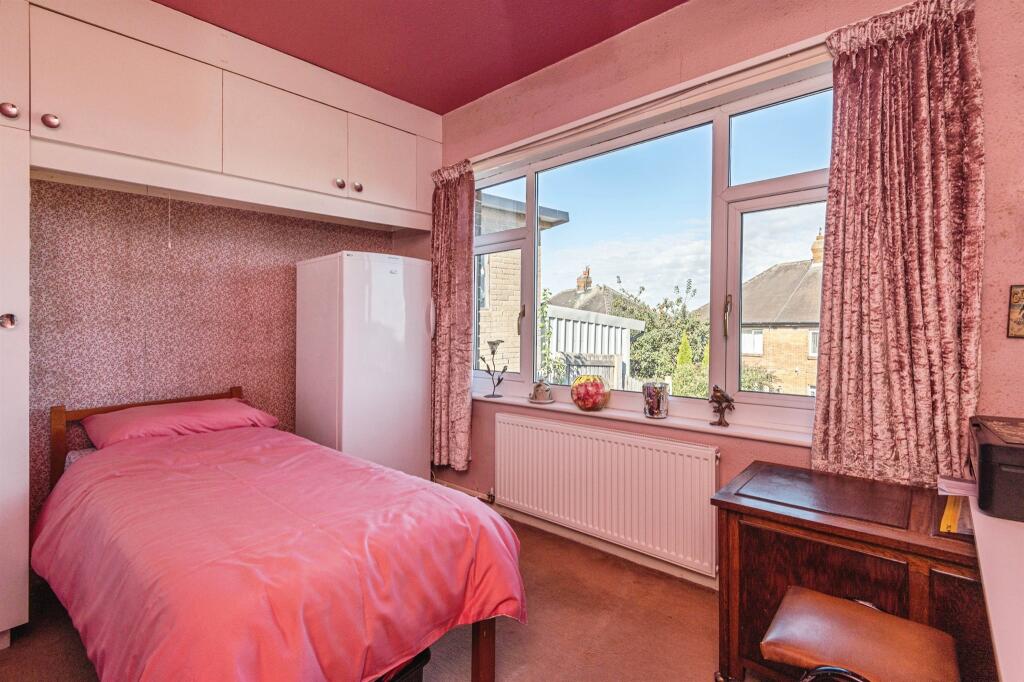
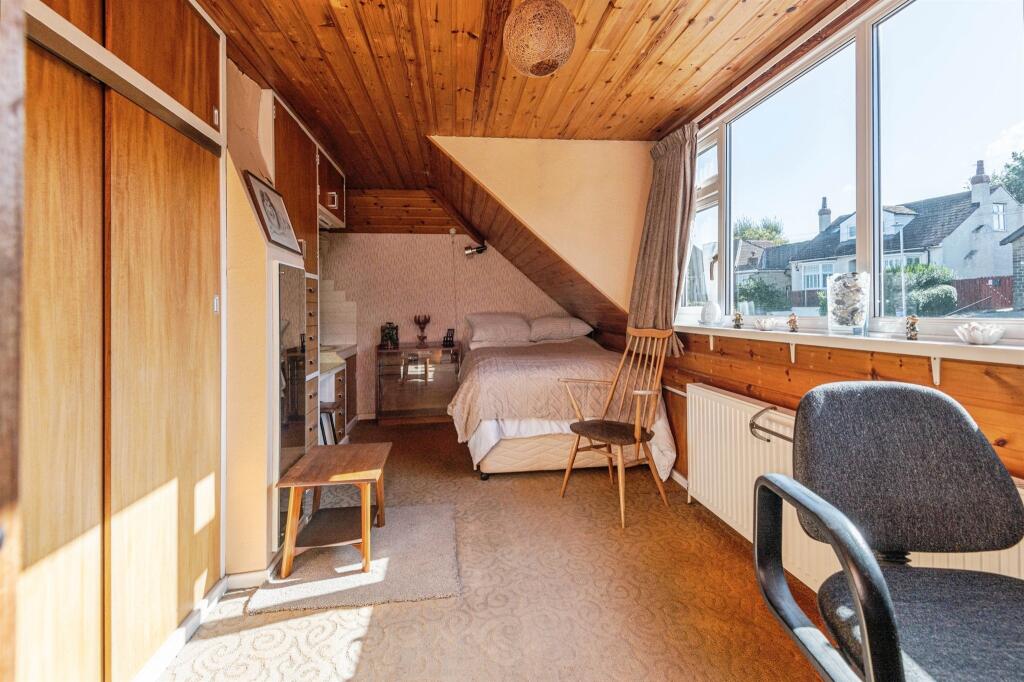
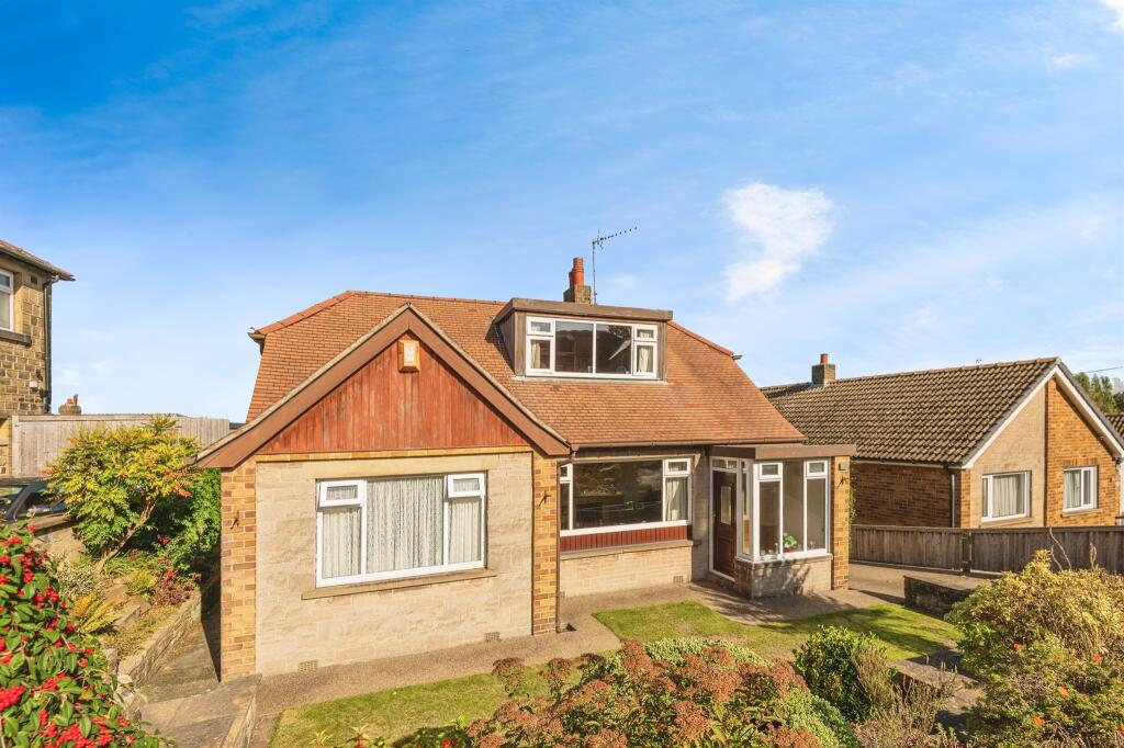
- Dormer-style semi-detached bungalow located on Jackroyd Lane, presented in good external condition. The property sits on a slightly elevated plot with a paved driveway and a small front garden with low boundary walls. Internally the accommodation appears to include a front reception room with a stone surround fireplace, a double bedroom with built-in wardrobes, and additional living space likely arranged over two levels (ground floor plus first-floor dormer). The plot offers a small to average sized rear garden (not fully shown) and off-street parking to the front. Overall property size is modest — suitable for downsizers or a small family — with potential for modernization and improvement to increase market value given the desirable residential setting and street presence.
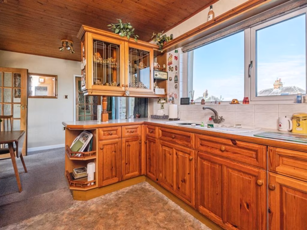
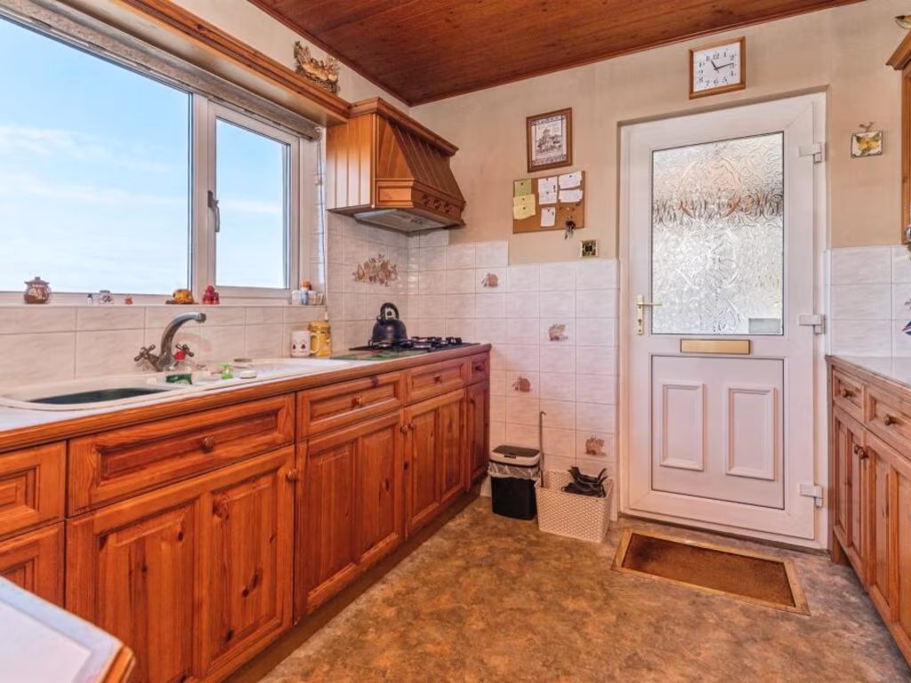
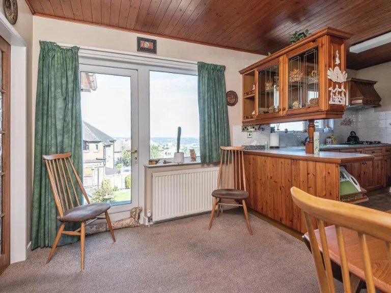
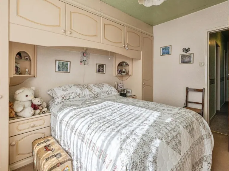
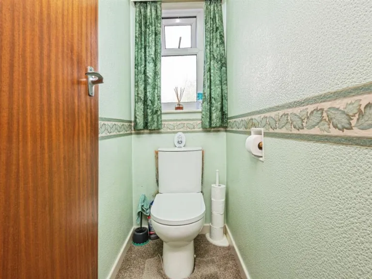
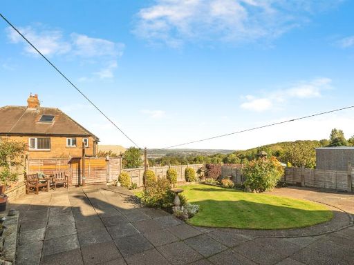
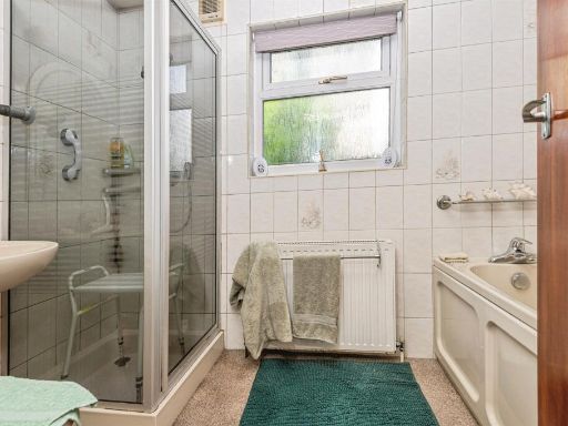
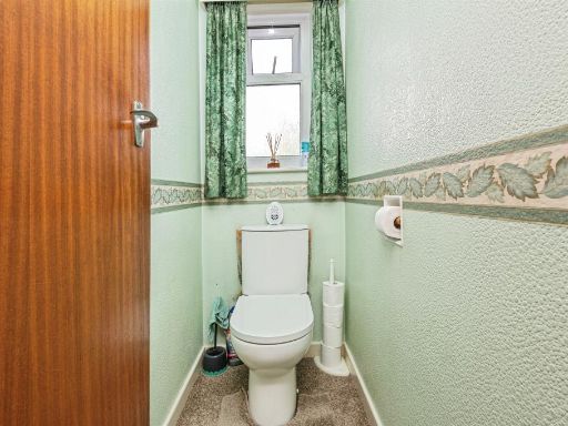
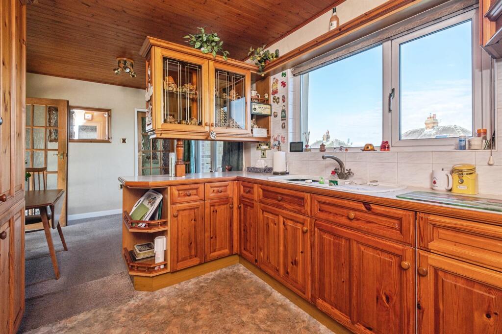
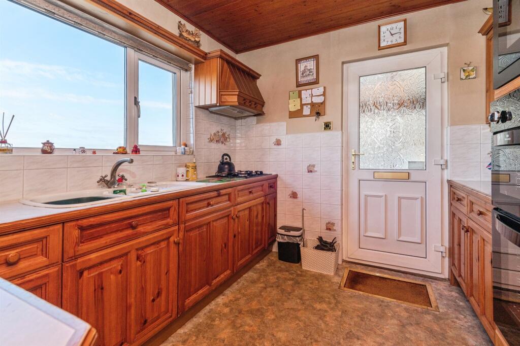
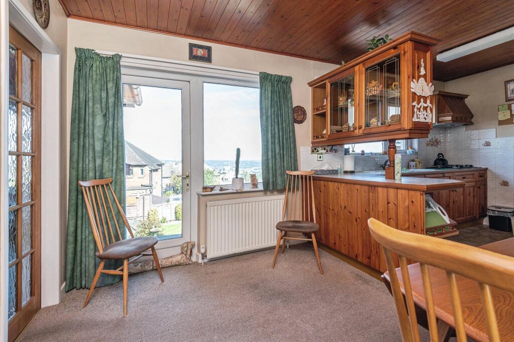
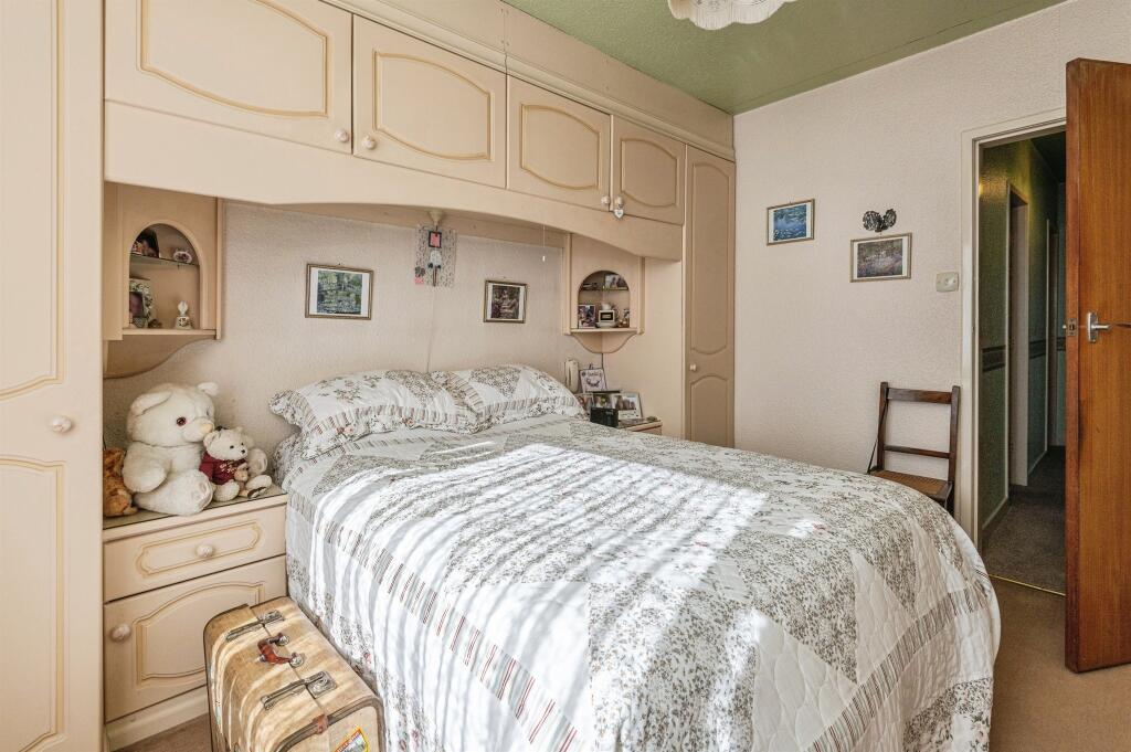
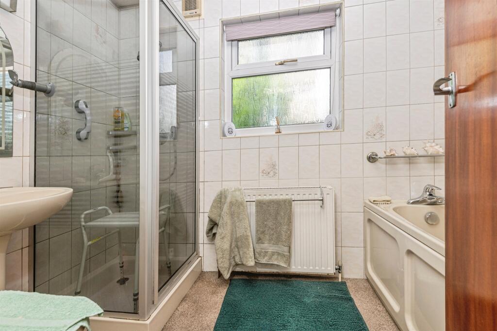
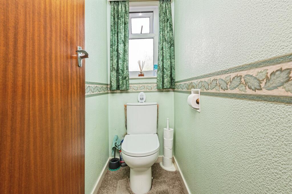
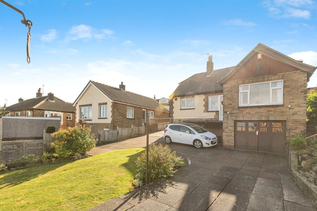
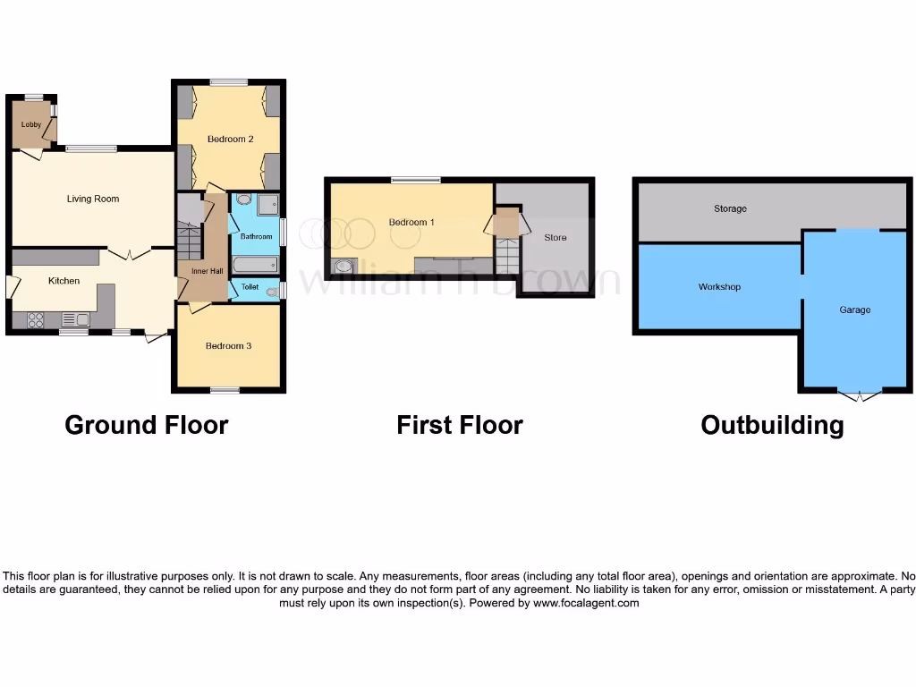
- Detached bungalow set in a generous plot on Jackroyd Lane, Huddersfield. The accommodation (as shown on the floorplan) provides a spacious living room, kitchen, two ground-floor bedrooms plus a first-floor bedroom, bathroom and WC. The site includes substantial outbuildings comprising a garage, workshop and additional storage, and a driveway with parking for multiple cars. The plot appears to have landscaped gardens and occupies a larger-than-average garden for this property type. Location is described as highly sought-after with views. Overall the property represents a spacious, detached bungalow on a large plot — suitable for buyers seeking a family bungalow with significant outdoor space and outbuildings. (Furniture and removable items excluded from description.)
Image Descriptions
- detached house mid-century
- living room 1980s
Rooms
- Lobby:
- Living Room:
- Kitchen:
- Inner Hall:
- Bedroom 2:
- Bedroom 3:
- Bathroom:
- Toilet:
- Bedroom 1:
- Store:
- Storage:
- Workshop:
- Garage:
Textual Property Features
- Has Garden
- Chain Free
- Success
Detected Visual Features
- detached house
- mid-century
- dormer windows
- pitched roof
- front garden
- driveway
- brick exterior
- living room
- fireplace
- stone fireplace
- 1980s
- suburban
- medium size
- standard ceiling
- natural light
- traditional design
EPC Details
- Fully double glazed
- Sandstone or limestone, as built, no insulation (assumed)
- Boiler and radiators, mains gas
- Low energy lighting in 9% of fixed outlets
- Suspended, no insulation (assumed)
Nearby Schools
- Honley CofE (VC) Junior, Infant and Nursery School
- Netherton Infant and Nursery School
- All Hallows' CofE (VA) Primary School
- Hillside Primary School
- Oak CofE Primary School
- St Joseph's Catholic Primary Academy
- Netherhall Learning Campus Junior School
- Birkby Infant and Nursery School
- St Patrick's Catholic Primary Academy
- Honley High School
- Mount Pleasant Primary School
- Moldgreen Community Primary School
- ES Independent School Kirklees
- Netherhall Learning Campus High School
- Brockholes Church of England Voluntary Controlled Junior and Infant School
- Farnley Tyas Church of England Voluntary Controlled First School
- Beaumont Primary Academy
- Lowerhouses CofE Primary School
- Spring Grove Junior Infant and Nursery School
- Birkby Junior School
- South Crosland Church of England Voluntary Aided Junior School
- Newsome Academy
- Moor End Academy
- Paddock Junior Infant and Nursery School
- Brambles Primary Academy
- Netherhall St James CofE (VC) Infant and Nursery School
Nearest Bars And Restaurants
- Id: 2406677451
- Tags:
- Amenity: pub
- Food: yes
- Name: The Lockwood
- Source: survey
- TagsNormalized:
- Lat: 53.6319302
- Lon: -1.7939343
- FullGeoHash: gcw9p5mswk3t
- PartitionGeoHash: gcw9
- Images:
- FoodStandards: null
- Distance: 978.9
,- Id: 4710330451
- Tags:
- Amenity: fast_food
- Cuisine: fish_and_chips
- Source: survey
- TagsNormalized:
- Lat: 53.6283647
- Lon: -1.7860905
- FullGeoHash: gcw9p6erv5f2
- PartitionGeoHash: gcw9
- Images:
- FoodStandards: null
- Distance: 360.9
,- Id: 1320123091
- Tags:
- Amenity: pub
- Name: Clarence
- Source: survey
- TagsNormalized:
- Lat: 53.6285563
- Lon: -1.7853174
- FullGeoHash: gcw9p6gbzp6z
- PartitionGeoHash: gcw9
- Images:
- FoodStandards: null
- Distance: 313.8
,- Id: 1320123078
- Tags:
- Amenity: pub
- Name: The Fountain
- Source: survey
- TagsNormalized:
- Lat: 53.6287682
- Lon: -1.7850944
- FullGeoHash: gcw9p6u4hqcp
- PartitionGeoHash: gcw9
- Images:
- FoodStandards: null
- Distance: 305.2
,- Id: 4710330452
- Tags:
- Amenity: fast_food
- Cuisine: fish_and_chips
- Source: survey
- TagsNormalized:
- Lat: 53.6283845
- Lon: -1.7839019
- FullGeoHash: gcw9p6tpbp6q
- PartitionGeoHash: gcw9
- Images:
- FoodStandards: null
- Distance: 218.5
}
Nearest General Shops
- Id: 2406677447
- Tags:
- Shop: car_repair
- Source: survey
- TagsNormalized:
- Lat: 53.6321418
- Lon: -1.7946665
- FullGeoHash: gcw9p5mjv5ze
- PartitionGeoHash: gcw9
- Images:
- FoodStandards: null
- Distance: 1032.6
,- Id: 2406677436
- Tags:
- TagsNormalized:
- Lat: 53.6321768
- Lon: -1.7946024
- FullGeoHash: gcw9p5mnndrk
- PartitionGeoHash: gcw9
- Images:
- FoodStandards: null
- Distance: 1030.6
,- Id: 1324360155
- Tags:
- TagsNormalized:
- Lat: 53.6298833
- Lon: -1.783736
- FullGeoHash: gcw9p7j0eyy5
- PartitionGeoHash: gcw9
- Images:
- FoodStandards: null
- Distance: 292.1
}
Nearest Grocery shops
- Id: 9035591995
- Tags:
- Brand: Nisa Local
- Name: Nisa Local
- Shop: convenience
- TagsNormalized:
- nisa
- nisa local
- convenience
- shop
- Lat: 53.6315574
- Lon: -1.7946329
- FullGeoHash: gcw9p5m4qnbt
- PartitionGeoHash: gcw9
- Images:
- FoodStandards: null
- Distance: 1003.2
,- Id: 1276282018
- Tags:
- TagsNormalized:
- Lat: 53.6362207
- Lon: -1.7827955
- FullGeoHash: gcw9pkjv9u5r
- PartitionGeoHash: gcw9
- Images:
- FoodStandards: null
- Distance: 925.2
,- Id: 2409297727
- Tags:
- Shop: convenience
- Source: survey
- TagsNormalized:
- Lat: 53.6318707
- Lon: -1.7871786
- FullGeoHash: gcw9p76s79r4
- PartitionGeoHash: gcw9
- Images:
- FoodStandards: null
- Distance: 608.8
}
Nearest Religious buildings
- Id: 131946467
- Tags:
- Amenity: place_of_worship
- Building: yes
- Denomination: Church of God of Prophecy
- Name: Church of God of Prophecy
- Old_name: Primrose Hill Methodist Church
- Religion: christian
- TagsNormalized:
- place of worship
- church
- christian
- Lat: 53.6357412
- Lon: -1.7804853
- FullGeoHash: gcw9pkp6zdvf
- PartitionGeoHash: gcw9
- Images:
- FoodStandards: null
- Distance: 861.1
,- Id: 1308161049
- Tags:
- Amenity: place_of_worship
- Denomination: anglican
- Name: Hall Bower Sunday School
- Religion: christian
- TagsNormalized:
- place of worship
- anglican
- school
- christian
- church
- Lat: 53.6260143
- Lon: -1.7734721
- FullGeoHash: gcw9pdkd5je7
- PartitionGeoHash: gcw9
- Images:
- FoodStandards: null
- Distance: 522.3
,- Id: 131946471
- Tags:
- Amenity: place_of_worship
- Building: church
- Denomination: anglican
- Name: St John's Church
- Religion: christian
- Wikidata: Q105104040
- TagsNormalized:
- place of worship
- church
- anglican
- christian
- Lat: 53.6280692
- Lon: -1.7834422
- FullGeoHash: gcw9p6tq4u9j
- PartitionGeoHash: gcw9
- Images:
- FoodStandards: null
- Distance: 184.1
}
Nearest Medical buildings
- Id: 2391472765
- Tags:
- Amenity: doctors
- Name: Meltham Road Surgery
- TagsNormalized:
- Lat: 53.6318367
- Lon: -1.7971425
- FullGeoHash: gcw9p57k5dcr
- PartitionGeoHash: gcw9
- Images:
- FoodStandards: null
- Distance: 1168.1
,- Id: 2376875672
- Tags:
- Amenity: pharmacy
- Name: Lockwood Pharmacy
- Source: survey
- TagsNormalized:
- Lat: 53.6332184
- Lon: -1.7949964
- FullGeoHash: gcw9p5sujs99
- PartitionGeoHash: gcw9
- Images:
- FoodStandards: null
- Distance: 1109.8
,- Id: 1321558128
- Tags:
- Amenity: doctors
- Source: survey
- TagsNormalized:
- Lat: 53.6291693
- Lon: -1.7847813
- FullGeoHash: gcw9p6uke9dx
- PartitionGeoHash: gcw9
- Images:
- FoodStandards: null
- Distance: 301.8
,- Id: 1321558054
- Tags:
- Amenity: pharmacy
- Dispensing: yes
- Name: Rowlands Pharmacy
- Source: survey
- TagsNormalized:
- pharmacy
- rowlands pharmacy
- Lat: 53.6290872
- Lon: -1.7846064
- FullGeoHash: gcw9p6ukpdmn
- PartitionGeoHash: gcw9
- Images:
- FoodStandards: null
- Distance: 287.5
}
Nearest Airports
- Id: 11519546
- Tags:
- Addr:
- City: Leeds
- Postcode: LS19 7TU
- Aerodrome: international
- Aerodrome:type: public
- Aeroway: aerodrome
- Iata: LBA
- Icao: EGNM
- Name: Leeds Bradford Airport
- Operator: Leeds Bradford Airport Limited
- Operator:type: private
- Ref: LBA
- Type: multipolygon
- Website: https://www.leedsbradfordairport.co.uk/
- Wikidata: Q8699
- Wikipedia: en:Leeds Bradford Airport
- TagsNormalized:
- airport
- international airport
- Lat: 53.8667047
- Lon: -1.660138
- FullGeoHash: gcwf6nph7cx3
- PartitionGeoHash: gcwf
- Images:
- Q8699-1
- Q8699-2
- Q8699-3
- Q8699-4
- FoodStandards: null
- Distance: 27700.7
}
Nearest Leisure Facilities
- Id: 727349093
- Tags:
- Leisure: pitch
- Name: Newsome Wmc Crown Green Bowls Club
- Sport: bowls
- TagsNormalized:
- pitch
- leisure
- bowls
- club
- sports
- Lat: 53.6282642
- Lon: -1.7849419
- FullGeoHash: gcw9p6sprc4b
- PartitionGeoHash: gcw9
- Images:
- FoodStandards: null
- Distance: 284.4
,- Id: 117580667
- Tags:
- Leisure: park
- Source: survey
- TagsNormalized:
- Lat: 53.6276235
- Lon: -1.7847667
- FullGeoHash: gcw9p6s7ect6
- PartitionGeoHash: gcw9
- Images:
- FoodStandards: null
- Distance: 274.5
,- Id: 203120678
- Tags:
- Leisure: pitch
- Source: survey
- Sport: rugby_league
- TagsNormalized:
- pitch
- leisure
- rugby
- rugby league
- sports
- Lat: 53.6267227
- Lon: -1.7780145
- FullGeoHash: gcw9pd3q338m
- PartitionGeoHash: gcw9
- Images:
- FoodStandards: null
- Distance: 224.4
,- Id: 117580663
- Tags:
- Leisure: park
- Source: survey
- TagsNormalized:
- Lat: 53.628541
- Lon: -1.7831991
- FullGeoHash: gcw9p6v8bkw7
- PartitionGeoHash: gcw9
- Images:
- FoodStandards: null
- Distance: 178.5
,- Id: 1320123065
- Tags:
- Leisure: playground
- Source: survey
- TagsNormalized:
- Lat: 53.6271399
- Lon: -1.7809037
- FullGeoHash: gcw9p6x0tzmy
- PartitionGeoHash: gcw9
- Images:
- FoodStandards: null
- Distance: 96.8
}
Nearest Tourist attractions
- Id: 4334615865
- Tags:
- Name: Heritage Quay
- Tourism: museum
- Website: http://heritagequay.org
- TagsNormalized:
- Lat: 53.6437531
- Lon: -1.7768955
- FullGeoHash: gcw9ptd1e26e
- PartitionGeoHash: gcw9
- Images:
- FoodStandards: null
- Distance: 1769.4
,- Id: 918058328
- Tags:
- Historic: monument
- Name: Victoria Tower
- Note: Tower to commemorate Diamond Jubilee of Queen Victoria
- Tourism: attraction
- TagsNormalized:
- Lat: 53.6222011
- Lon: -1.772215
- FullGeoHash: gcw9p9tebqu8
- PartitionGeoHash: gcw9
- Images:
- FoodStandards: null
- Distance: 851.5
,- Id: 986125363
- Tags:
- TagsNormalized:
- Lat: 53.6343511
- Lon: -1.7794436
- FullGeoHash: gcw9peb4xzww
- PartitionGeoHash: gcw9
- Images:
- FoodStandards: null
- Distance: 711
}
Nearest Train stations
- Id: 252822812
- Tags:
- Name: Mirfield
- Naptan:
- Network: National Rail
- Note: checkme, the 1852-base mapping doesn't fit too well
- Operator: Northern
- Platforms: 3
- Public_transport: station
- Railway: station
- Ref:
- Source: NPE
- Wikipedia: en:Mirfield railway station
- TagsNormalized:
- Lat: 53.6714301
- Lon: -1.6928647
- FullGeoHash: gcwc36x69rsx
- PartitionGeoHash: gcwc
- Images:
- FoodStandards: null
- Distance: 7536.6
,- Id: 3711588219
- Tags:
- Name: Shepley
- Naptan:
- Network: National Rail
- Public_transport: station
- Railway: station
- Ref:
- Source: NPE
- Wikipedia: en:Shepley railway station
- TagsNormalized:
- Lat: 53.5887533
- Lon: -1.7048254
- FullGeoHash: gcwbc5w94ewj
- PartitionGeoHash: gcwb
- Images:
- FoodStandards: null
- Distance: 6638.3
,- Id: 6012937552
- Tags:
- Name: Slaithwaite
- Naptan:
- Network: National Rail
- Operator: Northern
- Public_transport: station
- Railway: station
- Ref:
- Source: NPE
- Train: yes
- Wikipedia: en:Slaithwaite railway station
- TagsNormalized:
- Lat: 53.6241585
- Lon: -1.8806027
- FullGeoHash: gcw9j1yx6g8v
- PartitionGeoHash: gcw9
- Images:
- FoodStandards: null
- Distance: 6605
,- Id: 3711588220
- Tags:
- Name: Stocksmoor
- Naptan:
- Network: National Rail
- Public_transport: station
- Railway: station
- Ref:
- Source: NPE
- Wikipedia: en:Stocksmoor railway station
- TagsNormalized:
- Lat: 53.5941495
- Lon: -1.7232658
- FullGeoHash: gcwbbu90scxf
- PartitionGeoHash: gcwb
- Images:
- FoodStandards: null
- Distance: 5338.3
,- Id: 6012937553
- Tags:
- Name: Huddersfield
- Naptan:
- Network: National Rail
- Public_transport: station
- Railway: station
- Ref:
- Wheelchair: yes
- Wikipedia: en:Huddersfield railway station
- TagsNormalized:
- Lat: 53.64849
- Lon: -1.7847509
- FullGeoHash: gcw9pqkmh73k
- PartitionGeoHash: gcw9
- Images:
- FoodStandards: null
- Distance: 2294.6
}
Nearest Hotels
- Id: 204034967
- Tags:
- Addr:
- City: Huddersfield
- Country: GB
- Housenumber: 62
- Postcode: HD1 2BW
- Street: New Street
- Amenity: pub
- Fhrs:
- Name: Commercial Hotel
- Source:
- TagsNormalized:
- Lat: 53.6446089
- Lon: -1.7834855
- FullGeoHash: gcw9pmtq3zbu
- PartitionGeoHash: gcw9
- Images:
- FoodStandards: null
- Distance: 1856.5
,- Id: 1063666756
- Tags:
- Addr:
- City: Huddersfield
- Country: GB
- Housenumber: 4
- Postcode: HD1 2TT
- Street: Princess Street
- Amenity: pub
- Fhrs:
- Name: The County Hotel
- Source:
- TagsNormalized:
- Lat: 53.6433691
- Lon: -1.7828771
- FullGeoHash: gcw9pmmxrby3
- PartitionGeoHash: gcw9
- Images:
- FoodStandards: null
- Distance: 1715.5
,- Id: 893419018
- Tags:
- Amenity: pub
- Name: Victoria Hotel
- TagsNormalized:
- Lat: 53.6283524
- Lon: -1.7763044
- FullGeoHash: gcw9pddxc17q
- PartitionGeoHash: gcw9
- Images:
- FoodStandards: null
- Distance: 289.4
}
Tags
- detached house
- mid-century
- dormer windows
- pitched roof
- front garden
- driveway
- brick exterior
- living room
- fireplace
- stone fireplace
- 1980s
- suburban
- medium size
- standard ceiling
- natural light
- traditional design
Local Market Stats
- Average Price/sqft: £190
- Avg Income: £33700
- Rental Yield: 3.7%
- Social Housing: 10%
- Planning Success Rate: 87%
AirBnB Data
- 1km average: £67/night
- Listings in 1km: 1
Similar Properties
 2 bedroom detached bungalow for sale in Newsome Road, Huddersfield, HD4 — £199,950 • 2 bed • 1 bath • 636 ft²
 3 bedroom detached bungalow for sale in Gleneagles Way, Huddersfield, West Yorkshire, HD2 — £320,000 • 3 bed • 2 bath • 1260 ft²
 4 bedroom house for sale in Inglewood Avenue, Huddersfield, HD2 — £550,000 • 4 bed • 2 bath • 1905 ft²
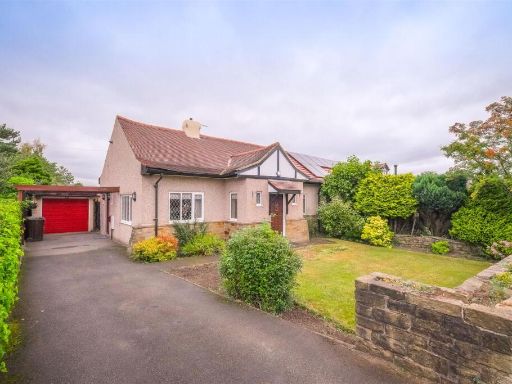 2 bedroom semi-detached bungalow for sale in New Hey Road, Huddersfield, hd3, HD3 — £275,000 • 2 bed • 1 bath • 1197 ft²
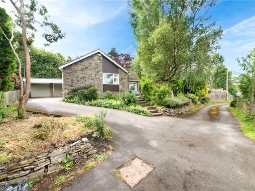 3 bedroom bungalow for sale in Ashes Lane, Almondbury, Huddersfield, HD4 — £450,000 • 3 bed • 1 bath • 1046 ft²
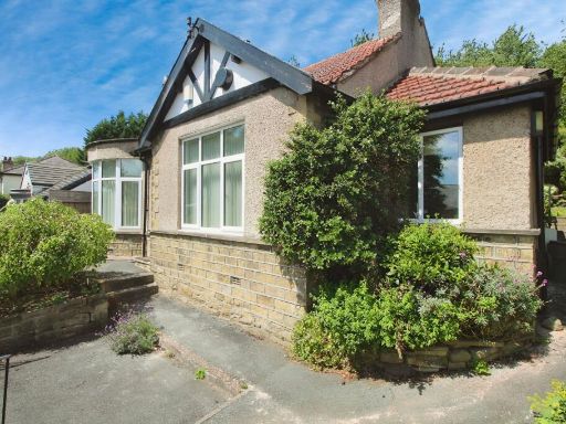 2 bedroom bungalow for sale in Heaton Road, Gledholt, Huddersfield, West Yorkshire, HD1 — £230,000 • 2 bed • 1 bath • 925 ft²
Meta
- {
"@context": "https://schema.org",
"@type": "Residence",
"name": "3 bedroom detached bungalow for sale in Jackroyd Lane, Hudd…",
"description": "",
"url": "https://propertypiper.co.uk/property/8a8d1d4c-b616-48e6-a9f6-3dee8faca42e",
"image": "https://image-a.propertypiper.co.uk/f39915b4-7d2d-4f41-8b55-f3e355367a40-1024.jpeg",
"address": {
"@type": "PostalAddress",
"streetAddress": "41 JACKROYD LANE, NEWSOME, HUDDERSFIELD",
"postalCode": "HD4 6RB",
"addressLocality": "Kirklees",
"addressRegion": "Huddersfield",
"addressCountry": "England"
},
"geo": {
"@type": "GeoCoordinates",
"latitude": 53.6279975,
"longitude": -1.7806526
},
"numberOfRooms": 3,
"numberOfBathroomsTotal": 1,
"floorSize": {
"@type": "QuantitativeValue",
"value": 1163,
"unitCode": "FTK"
},
"offers": {
"@type": "Offer",
"price": 300000,
"priceCurrency": "GBP",
"availability": "https://schema.org/InStock"
},
"additionalProperty": [
{
"@type": "PropertyValue",
"name": "Feature",
"value": "detached house"
},
{
"@type": "PropertyValue",
"name": "Feature",
"value": "mid-century"
},
{
"@type": "PropertyValue",
"name": "Feature",
"value": "dormer windows"
},
{
"@type": "PropertyValue",
"name": "Feature",
"value": "pitched roof"
},
{
"@type": "PropertyValue",
"name": "Feature",
"value": "front garden"
},
{
"@type": "PropertyValue",
"name": "Feature",
"value": "driveway"
},
{
"@type": "PropertyValue",
"name": "Feature",
"value": "brick exterior"
},
{
"@type": "PropertyValue",
"name": "Feature",
"value": "living room"
},
{
"@type": "PropertyValue",
"name": "Feature",
"value": "fireplace"
},
{
"@type": "PropertyValue",
"name": "Feature",
"value": "stone fireplace"
},
{
"@type": "PropertyValue",
"name": "Feature",
"value": "1980s"
},
{
"@type": "PropertyValue",
"name": "Feature",
"value": "suburban"
},
{
"@type": "PropertyValue",
"name": "Feature",
"value": "medium size"
},
{
"@type": "PropertyValue",
"name": "Feature",
"value": "standard ceiling"
},
{
"@type": "PropertyValue",
"name": "Feature",
"value": "natural light"
},
{
"@type": "PropertyValue",
"name": "Feature",
"value": "traditional design"
}
]
}
High Res Floorplan Images
Compatible Floorplan Images
FloorplanImages Thumbnail