TS17 5NA - 4 bedroom detached house for sale in The Orchard, Ingleby B…
View on Property Piper
4 bedroom detached house for sale in The Orchard, Ingleby Barwick, TS17
Property Details
- Price: £389995
- Bedrooms: 4
- Bathrooms: 2
- Property Type: undefined
- Property SubType: undefined
Brochure Descriptions
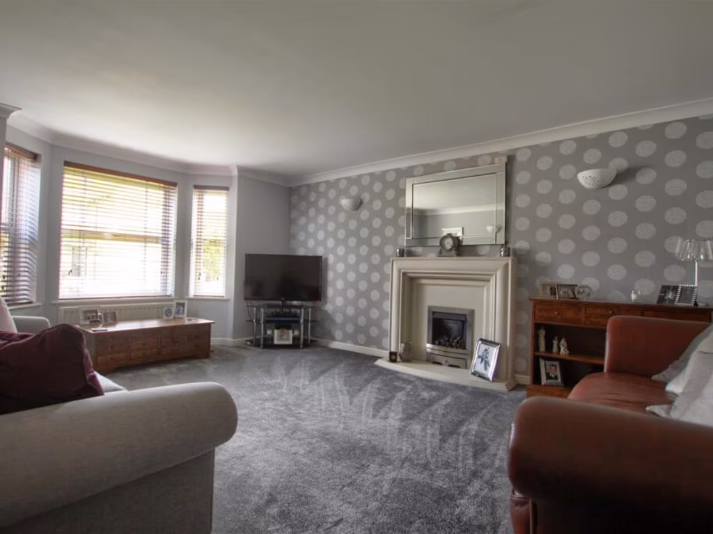
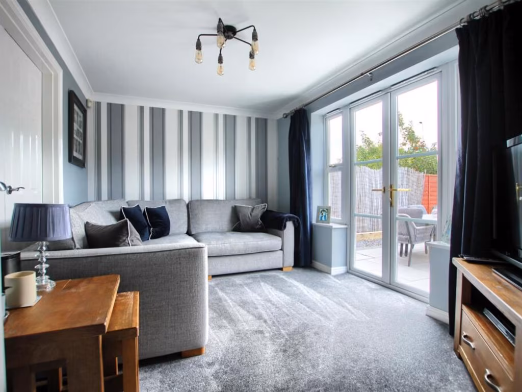
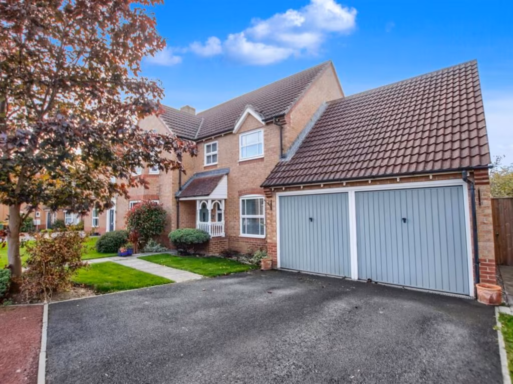
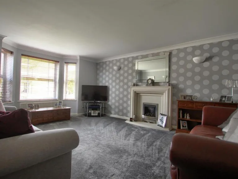
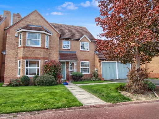
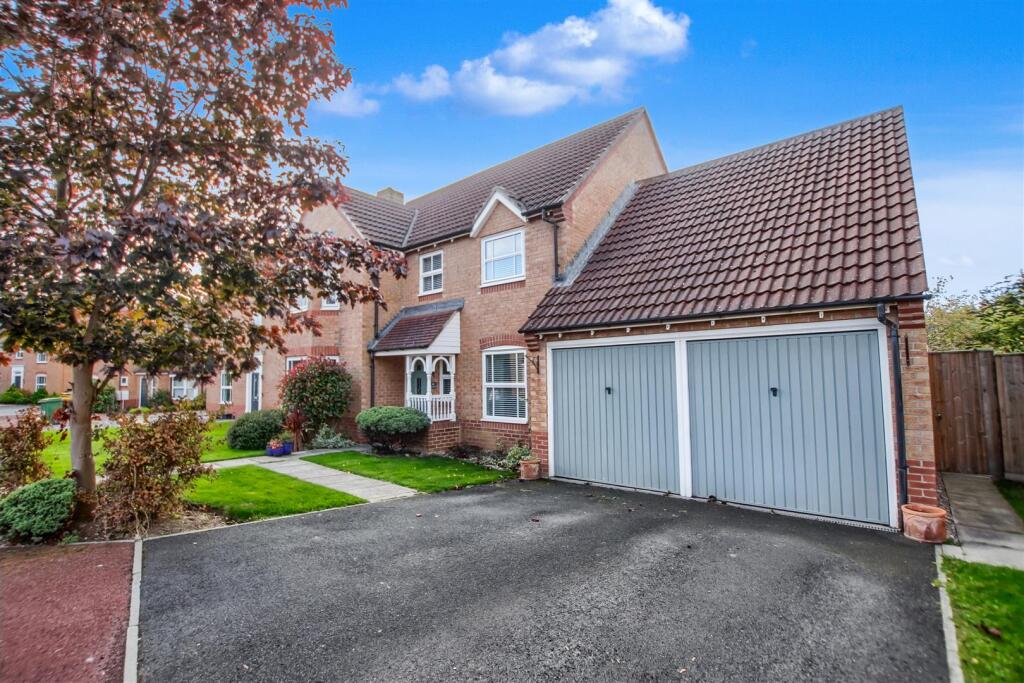
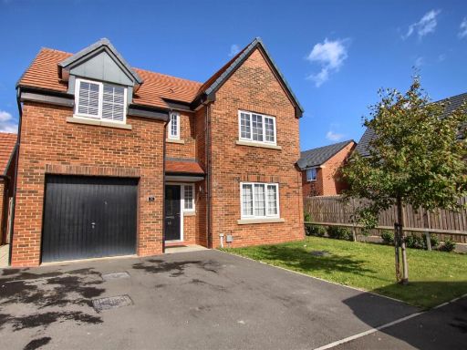
- Detached two‑storey brick family house with integral double garage and private driveway. The property presents a traditional bay window to the front, pitched tiled roof and a covered porch entrance. Front garden is well‑kept and of average size for a suburban plot; overall site likely to be a medium sized residential plot. The house appears to offer multiple reception rooms and first‑floor bedrooms (typical 3–4 bedroom layout for this style). Setting is a residential estate/street with neighbouring similar houses; no exceptional views visible (suburban/street scene). Condition and external finishes appear good with mature shrub planting and an established tree to the front.
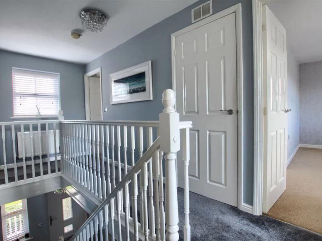
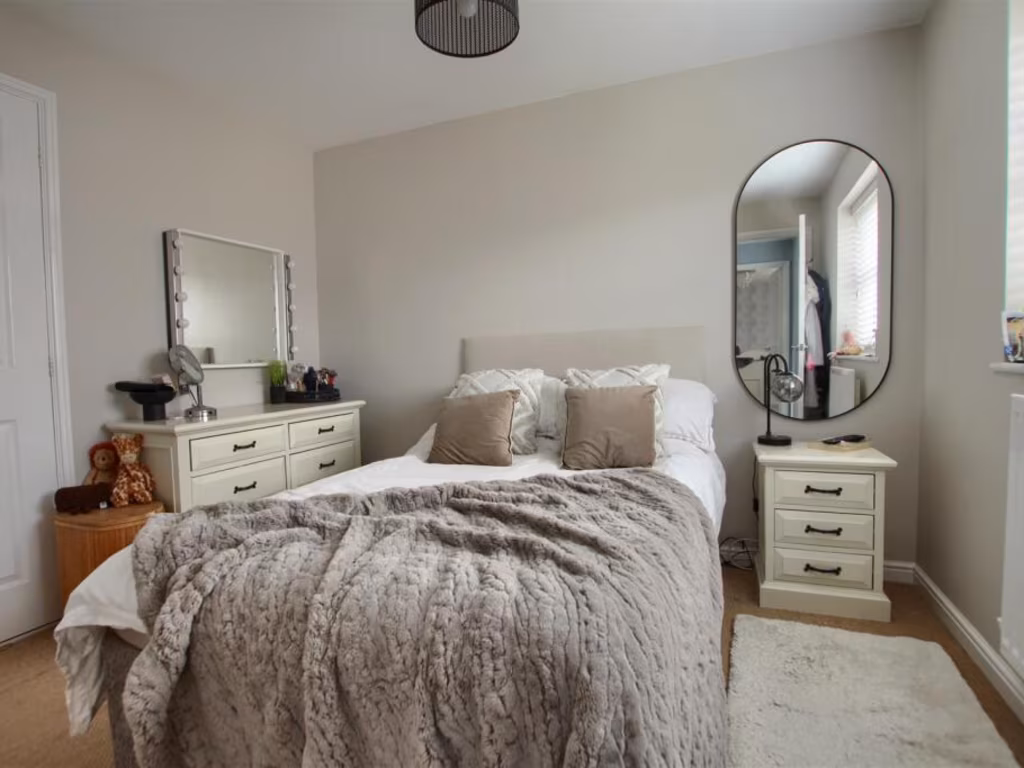
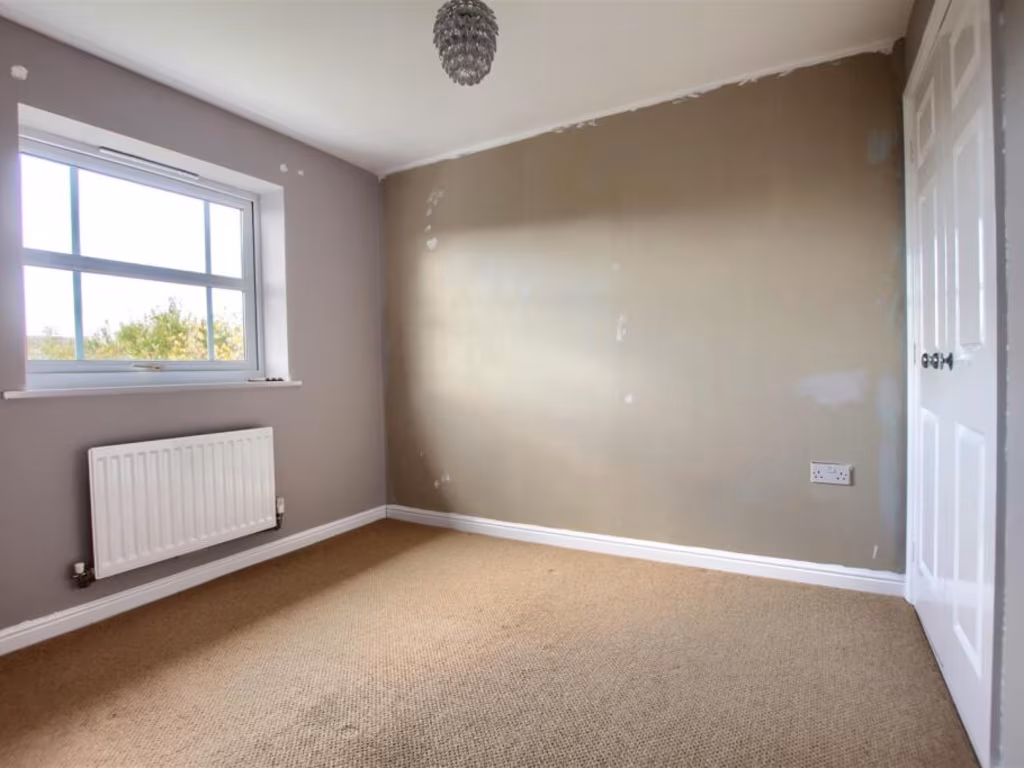
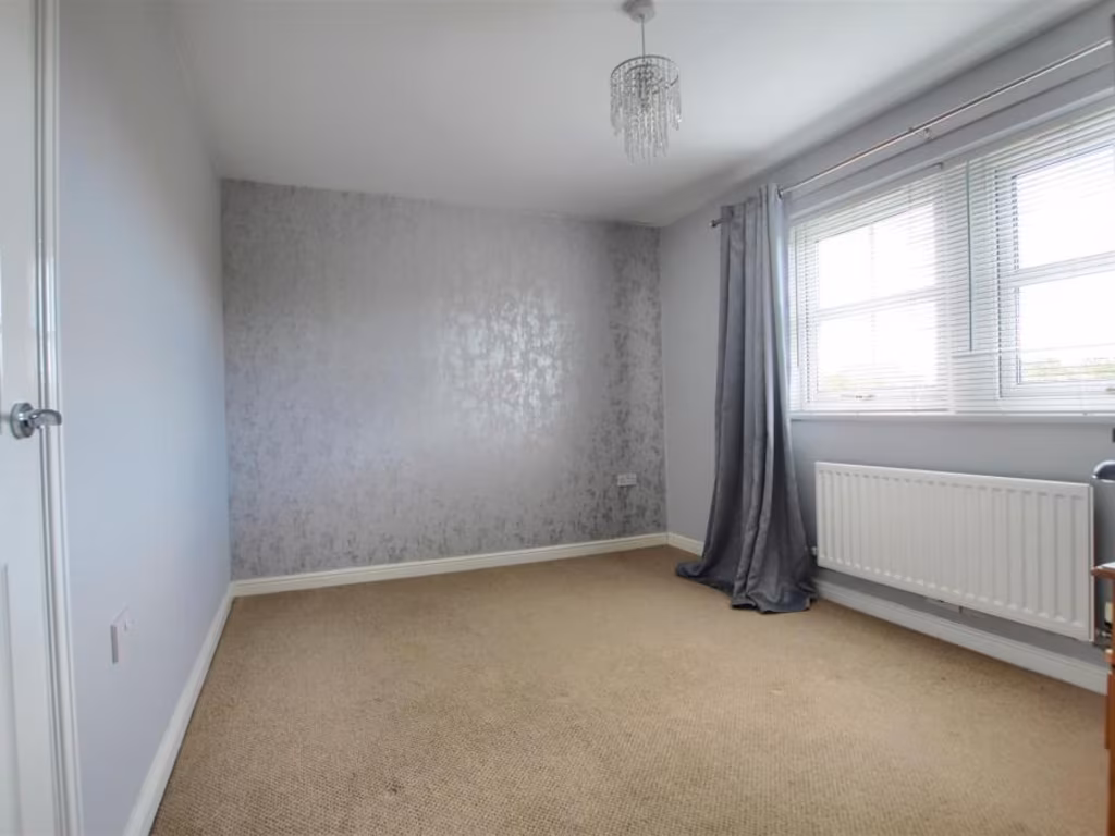
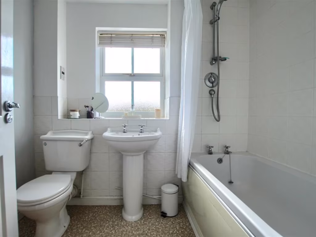
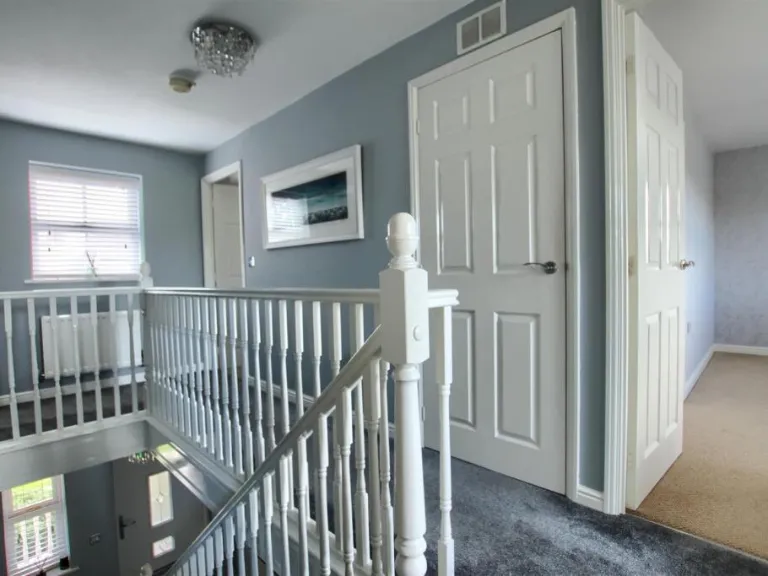
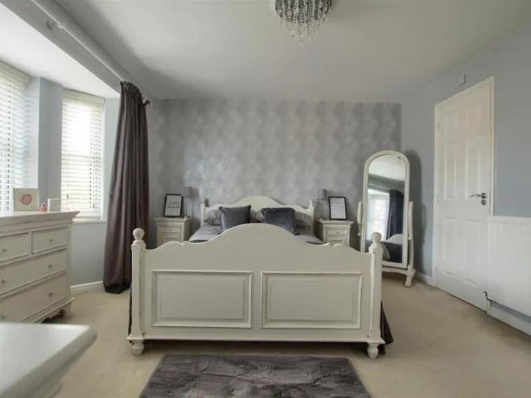
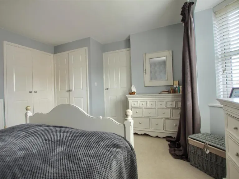
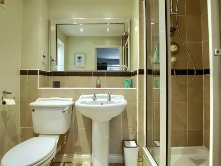
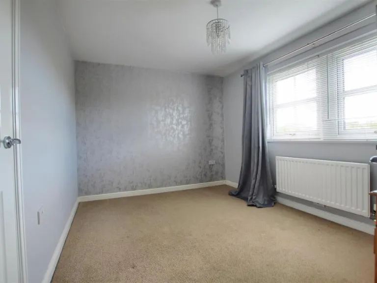
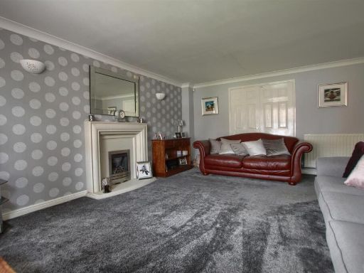
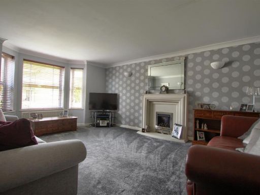
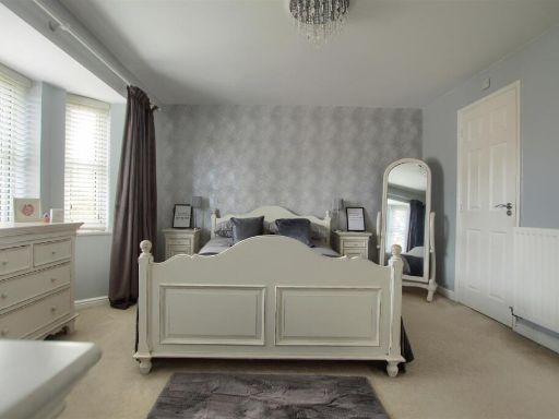
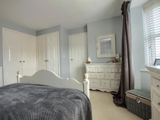
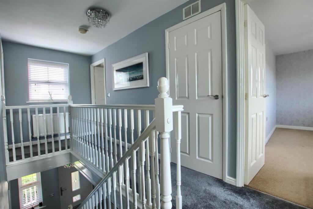
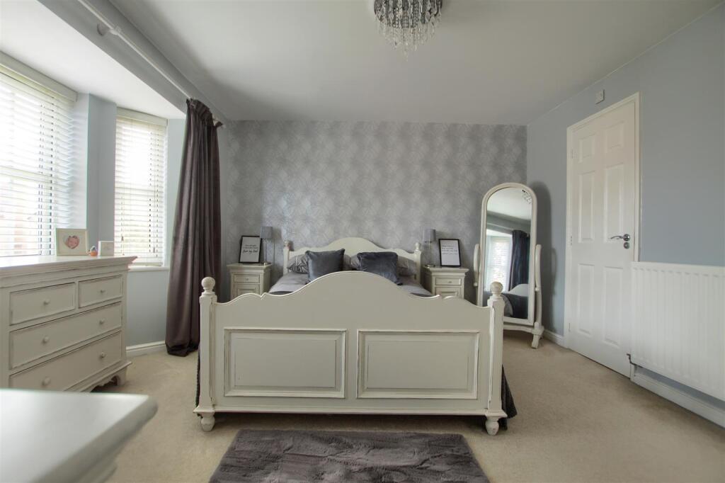
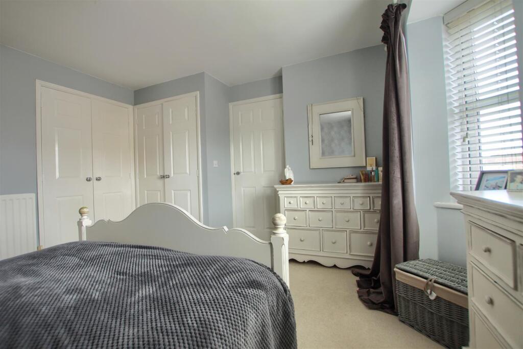
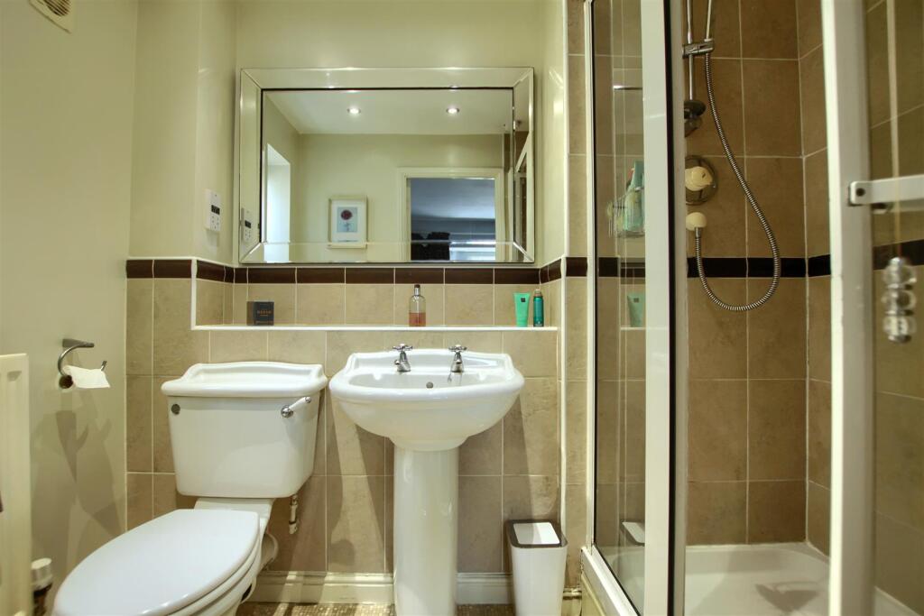
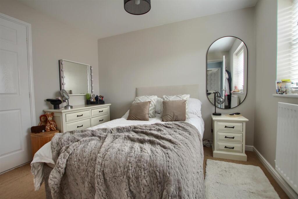
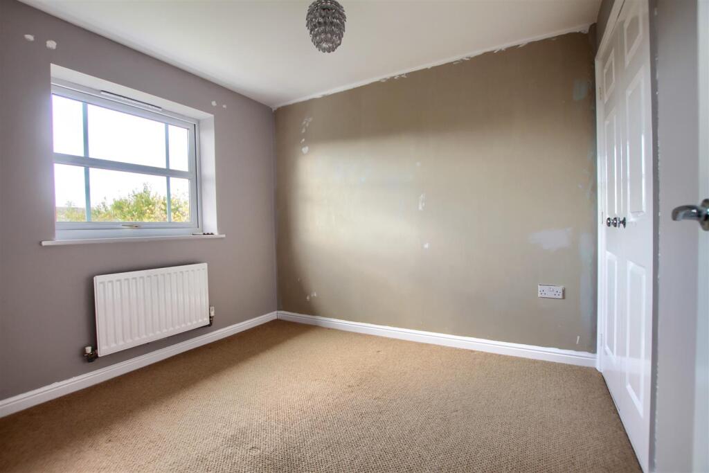
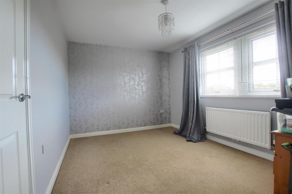
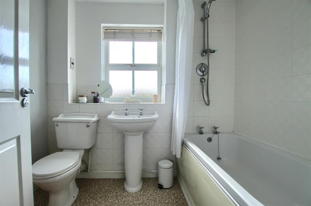
- Well-presented, modern mid-sized residential property shown across six images. Photographs focus on the upper floor: a bright landing with painted spindle balustrade and access to bedrooms; a principal bedroom of generous/large proportion with bay-style window or multiple casement windows providing good natural light, fitted radiators and neutral carpets; an en-suite or bathroom with a separate shower cubicle, basin and WC finished in contemporary tiles and fixtures; at least one further double bedroom with built-in wardrobes and fitted storage/dressers. Décor is neutral and well maintained (soft greys, creams), with PVCu double-glazed windows and modern internal doors. Overall the accommodation appears to be in good condition with ample built-in storage and a comfortable, family-focused layout. No external grounds or views (sea/river/woodland/city) are visible in the images. Room sizes: bedrooms — average to large; overall property size — medium (family house).
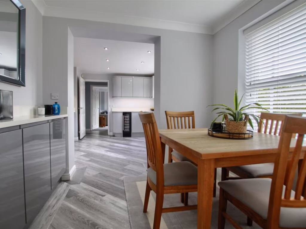
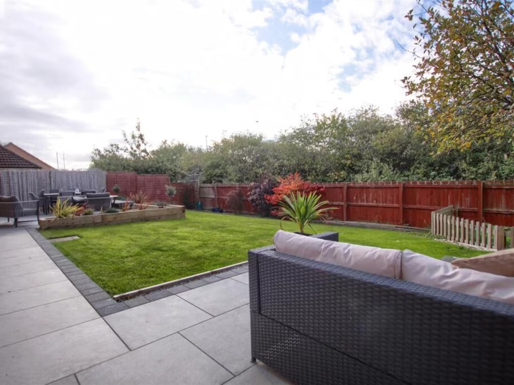
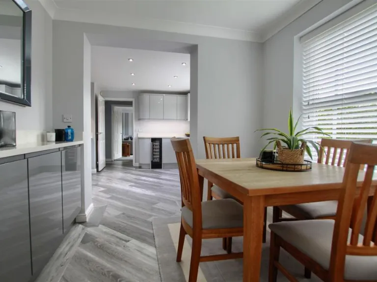
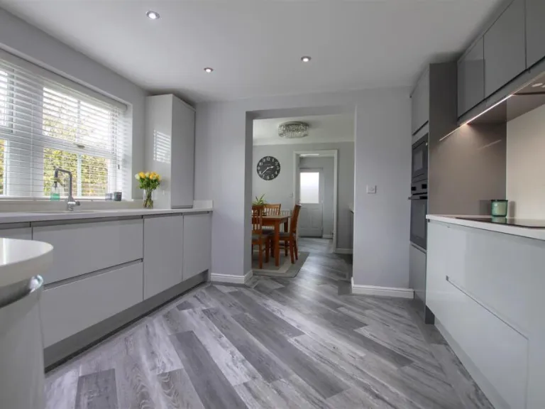
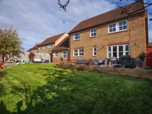
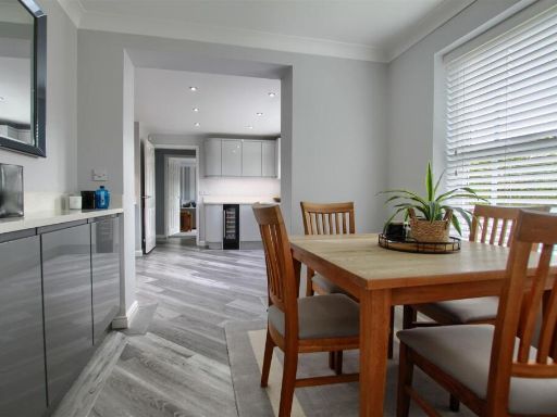
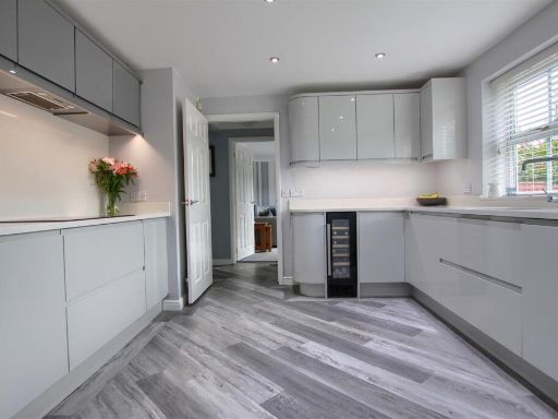
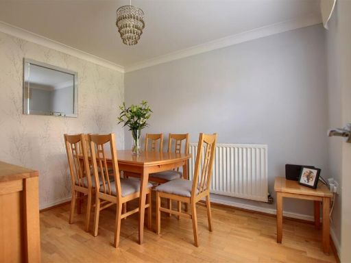
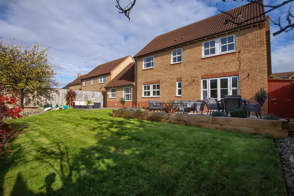
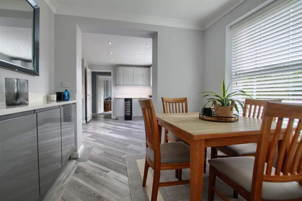
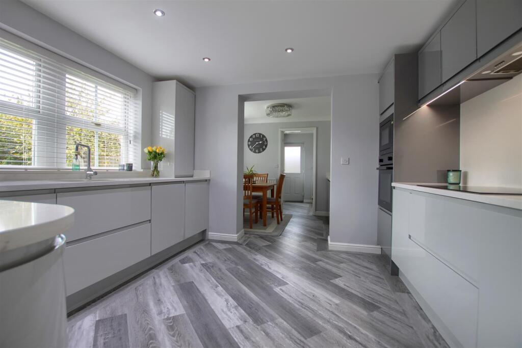
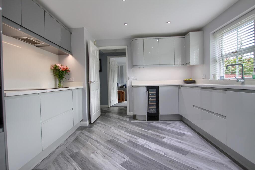
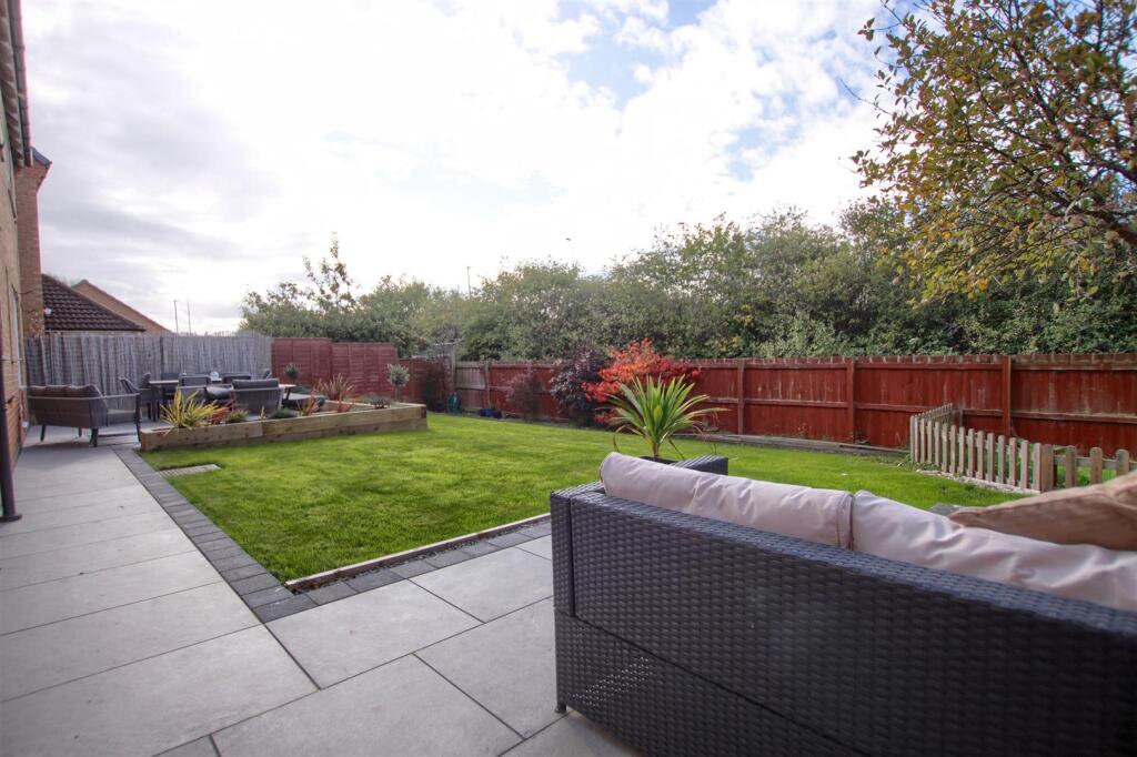
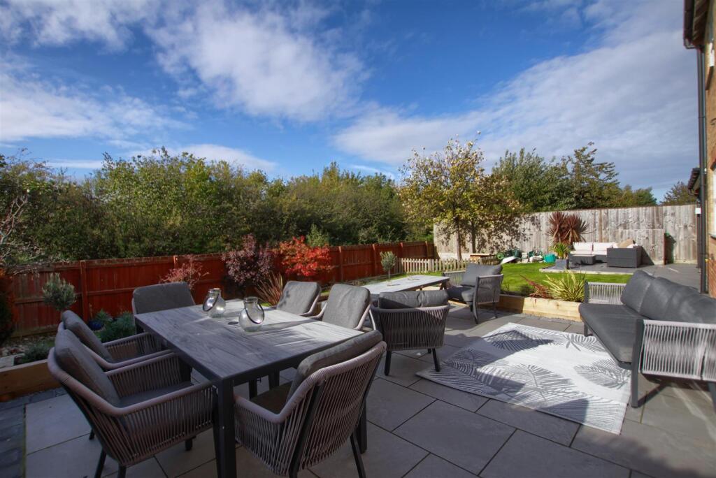
- Well-presented modern two-storey family home (likely 3–4 bedrooms) constructed in brick with a pitched tiled roof. The rear elevation opens onto a level, well-kept lawned garden with a raised paved/terraced seating area and fenced boundaries — garden size appears average to slightly above average for a suburban plot. Interiors have been recently refurbished to a neutral, contemporary specification: high-quality grey handleless kitchen cabinetry, integrated appliances (including a wine cooler), durable wood-effect vinyl flooring laid in a chevron/diagonal pattern, recessed LED downlights and good natural light from large rear windows. The layout provides a formal dining area adjoining the kitchen and a generous circulation space, indicating sensible family-focused accommodation. Overall condition appears excellent with modern finishes throughout. Key value drivers: turnkey presentation, modern fitted kitchen, good private rear garden and strong natural light. Potential considerations: unknown bedroom/bathroom count and parking provision (not visible), which will affect valuation and market banding.
Image Descriptions
- 2-storey detached house Contemporary
- backyard modern suburban
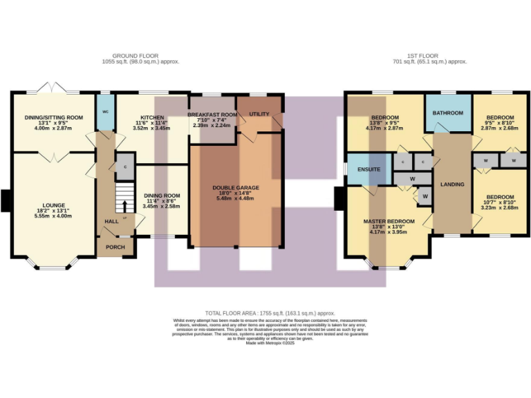
Floorplan Description
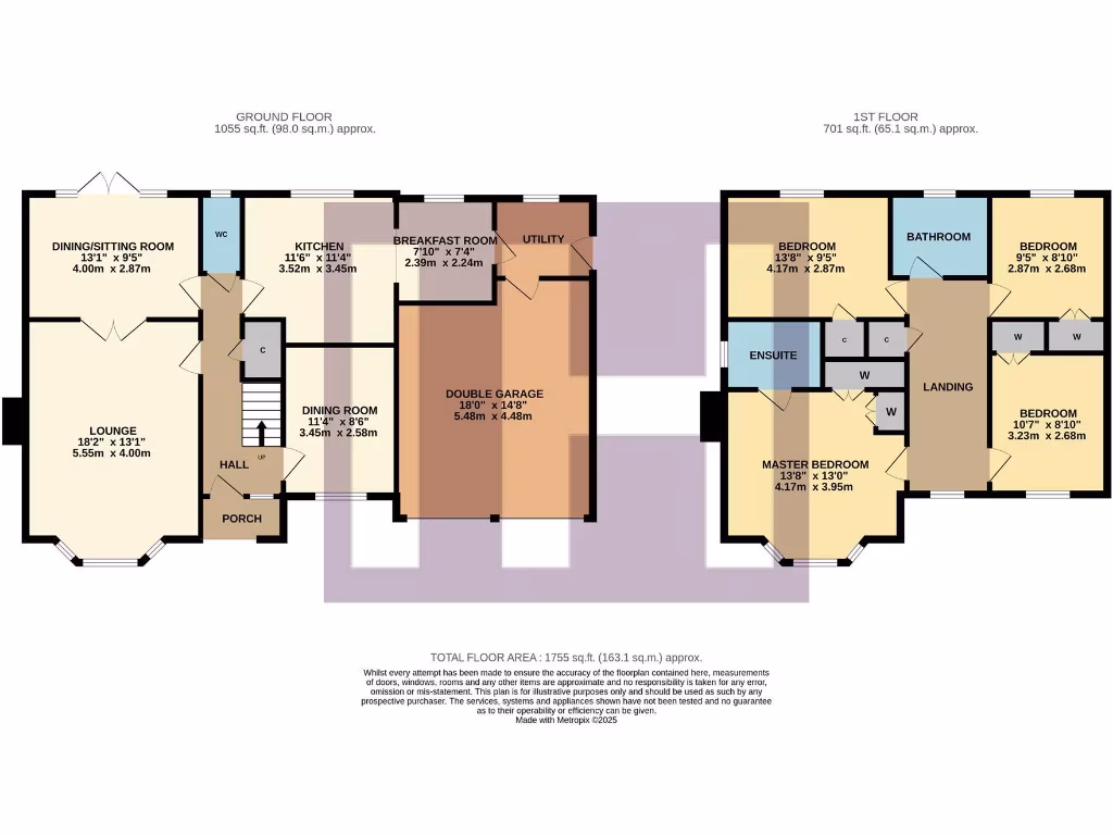
- Floorplan showing ground and first floor with room dimensions labeled on plan
Rooms
- DINING/SITTING ROOM:
- LOUNGE:
- KITCHEN:
- BREAKFAST ROOM:
- DINING ROOM:
- DOUBLE GARAGE:
- MASTER BEDROOM:
- ENSUITE:
- BEDROOM:
- BEDROOM:
- BEDROOM:
Textual Property Features
Detected Visual Features
- detached house
- modern construction
- bay windows
- two-storey
- brick facade
- garage
- driveway
- grass lawn
- well-maintained
- suburban
- modern
- detached
- brick
- garden
- patio
- family home
- quiet neighborhood
EPC Details
- Fully double glazed
- Cavity wall, as built, insulated (assumed)
- Boiler and radiators, mains gas
- No low energy lighting
- Suspended, no insulation (assumed)
Nearby Schools
- Yarm School
- Ingleby Manor Free School & Sixth Form
- St Therese of Lisieux Catholic Primary School, A Voluntary Catholic Academy
- Myton Park Primary School
- Thornaby Church of England Primary School
- St. Patrick's Roman Catholic Primary School, A Voluntary Catholic Academy
- Oxbridge Lane Primary School
- Levendale Primary School
- Ingleby Mill Primary School
- Egglescliffe Church of England Primary School
- Barley Fields Primary
- All Saints Church of England Academy
- Whinstone Primary School
- St Francis of Assisi Church of England Primary School
- Bader Primary School
- Thornaby Academy
- Village Primary School
- Hartburn Primary School
- Bowesfield Primary School
- Yarm Primary School
- Junction Farm Primary School
- Teesside High School
- Preston Primary School
- Mandale Mill Primary School
- The Links Primary School
- Christ The King Roman Catholic Primary School, A Voluntary Catholic Academy
- St Patrick's Catholic College, A Voluntary Catholic Academy
- St Cuthbert's Catholic Primary School, Stockton
Nearest General Shops
- Id: 1269877056
- Tags:
- Name: Fix It DIY
- Shop: doityourself
- TagsNormalized:
- Lat: 54.5222034
- Lon: -1.322712
- FullGeoHash: gcxn1vkyfe67
- PartitionGeoHash: gcxn
- Images:
- FoodStandards: null
- Distance: 453.8
,- Id: 9210157278
- Tags:
- Brand: Cooplands
- Brand:wikidata: Q5167971
- Brand:wikipedia: en:Cooplands
- Name: Cooplands
- Shop: bakery
- TagsNormalized:
- Lat: 54.5223142
- Lon: -1.3223445
- FullGeoHash: gcxn1vmpe0h2
- PartitionGeoHash: gcxn
- Images:
- FoodStandards: null
- Distance: 442
,- Id: 9210157279
- Tags:
- Name: Banardos
- Shop: charity
- TagsNormalized:
- Lat: 54.5223469
- Lon: -1.3222345
- FullGeoHash: gcxn1vmptwn7
- PartitionGeoHash: gcxn
- Images:
- FoodStandards: null
- Distance: 438.7
}
Nearest Religious buildings
- Id: 1136974013
- Tags:
- Amenity: place_of_worship
- Building: yes
- Denomination: catholic
- Name: St Therese of Lisieux Catholic Church
- Religion: christian
- TagsNormalized:
- place of worship
- catholic
- church
- christian
- Lat: 54.5144198
- Lon: -1.3140553
- FullGeoHash: gcxn4h51s23k
- PartitionGeoHash: gcxn
- Images:
- FoodStandards: null
- Distance: 1431.8
,- Id: 59536492
- Tags:
- Amenity: place_of_worship
- Building: yes
- Denomination: anglican
- Name: St. Francis of Assisi Church of England
- Religion: christian
- Wikidata: Q105106944
- TagsNormalized:
- place of worship
- anglican
- church
- christian
- Lat: 54.5159846
- Lon: -1.3142943
- FullGeoHash: gcxn4h6fwsp5
- PartitionGeoHash: gcxn
- Images:
- FoodStandards: null
- Distance: 1266.6
,- Id: 38964076
- Tags:
- Addr:
- Amenity: school
- Capacity: 420
- Denomination: anglican
- Diocese: Diocese of York
- Isced:
- Max_age: 11
- Min_age: 3
- Name: St Francis of Assisi Church of England Primary School
- Phone: +44 1642 769942
- Ref:
- Ref:edubase:group: 16867
- Religion: christian
- School:
- Boarding: no
- Gender: mixed
- Selective: no
- Trust: yes
- Type: academy
- School:trust:name: Dales Academies Trust
- School:trust:type: multi_academy
- Source:
- Addr:
- Postcode: get-information-schools.service.gov.uk
- Website: https://www.stfrancispri.dalesmat.org/
- Wikidata: Q66139348
- TagsNormalized:
- school
- anglican
- church
- christian
- Lat: 54.5275122
- Lon: -1.3205843
- FullGeoHash: gcxn1yqmu1hb
- PartitionGeoHash: gcxn
- Images:
- FoodStandards: null
- Distance: 192
}
Nearest Medical buildings
- Id: 8450802927
- Tags:
- Addr:
- City: Eaglescliffe
- Housenumber: 13
- Postcode: TS16 0BU
- Street: Station Road
- Amenity: dentist
- Brand: mydentist
- Brand:wikidata: Q65118035
- Healthcare: dentist
- Name: mydentist
- TagsNormalized:
- Lat: 54.5297263
- Lon: -1.3480767
- FullGeoHash: gcxn1qf6et9p
- PartitionGeoHash: gcxn
- Images:
- FoodStandards: null
- Distance: 1683.1
,- Id: 186019726
- Tags:
- Amenity: pharmacy
- Created_by: Potlatch 0.6a
- Dispensing: yes
- Name: Kellys
- TagsNormalized:
- Lat: 54.5180761
- Lon: -1.3187171
- FullGeoHash: gcxn1uxwz9vr
- PartitionGeoHash: gcxn
- Images:
- FoodStandards: null
- Distance: 947.8
,- Id: 251618380
- Tags:
- Amenity: doctors
- Created_by: Potlatch 0.7b
- TagsNormalized:
- Lat: 54.5183617
- Lon: -1.3184289
- FullGeoHash: gcxn1uzbqrhp
- PartitionGeoHash: gcxn
- Images:
- FoodStandards: null
- Distance: 922.6
,- Id: 1145154867
- Tags:
- Amenity: doctors
- Building: yes
- Healthcare: doctor
- Name: TBMG
- TagsNormalized:
- doctor
- doctors
- health
- healthcare
- Lat: 54.5238872
- Lon: -1.3103824
- FullGeoHash: gcxn4jvb9vk0
- PartitionGeoHash: gcxn
- Images:
- FoodStandards: null
- Distance: 837
}
Nearest Leisure Facilities
- Id: 42260713
- Tags:
- TagsNormalized:
- Lat: 54.5228468
- Lon: -1.3171943
- FullGeoHash: gcxn4j8fe5k9
- PartitionGeoHash: gcxn
- Images:
- FoodStandards: null
- Distance: 520.8
,- Id: 871837002
- Tags:
- TagsNormalized:
- Lat: 54.522869
- Lon: -1.3251996
- FullGeoHash: gcxn1ve48x7w
- PartitionGeoHash: gcxn
- Images:
- FoodStandards: null
- Distance: 413.2
,- Id: 871837003
- Tags:
- TagsNormalized:
- Lat: 54.5228504
- Lon: -1.3246307
- FullGeoHash: gcxn1ve6tggz
- PartitionGeoHash: gcxn
- Images:
- FoodStandards: null
- Distance: 402.1
,- Id: 871836981
- Tags:
- Leisure: park
- Name: Hazeldene Park
- Opening_hours: 24/7
- Operator: Stockton Council
- TagsNormalized:
- Lat: 54.5229422
- Lon: -1.3243636
- FullGeoHash: gcxn1veehj4f
- PartitionGeoHash: gcxn
- Images:
- FoodStandards: null
- Distance: 387.2
,- Id: 974691506
- Tags:
- Leisure: park
- Name: Bowood Park
- Opening_hours: 24/7
- Operator: Stockton Council
- TagsNormalized:
- Lat: 54.525013
- Lon: -1.3209677
- FullGeoHash: gcxn1vyp5pp5
- PartitionGeoHash: gcxn
- Images:
- FoodStandards: null
- Distance: 179.3
}
Nearest Tourist attractions
- Id: 473559997
- Tags:
- Addr:
- City: Eaglescliffe
- Postcode: TS18 3RH
- Street: Yarm Road
- Fee: yes
- Name: Preston Park Museum
- Tourism: museum
- Website: https://www.prestonparkmuseum.co.uk/
- Wikidata: Q7241901
- Wikipedia: en:Preston Hall, Preston-on-Tees
- TagsNormalized:
- Lat: 54.5356206
- Lon: -1.337356
- FullGeoHash: gcxn1xfjj2e0
- PartitionGeoHash: gcxn
- Images:
- FoodStandards: null
- Distance: 1405.3
,- Id: 854079087
- Tags:
- TagsNormalized:
- Lat: 54.5350326
- Lon: -1.3381364
- FullGeoHash: gcxn1xc9e4vh
- PartitionGeoHash: gcxn
- Images:
- FoodStandards: null
- Distance: 1393.3
,- Id: 59594867
- Tags:
- Name: Preston Park
- Tourism: attraction
- Wikidata: Q7241962
- Wikipedia: en:Preston Park, Stockton-on-Tees
- TagsNormalized:
- Lat: 54.5356203
- Lon: -1.3366602
- FullGeoHash: gcxn1xftj83y
- PartitionGeoHash: gcxn
- Images:
- FoodStandards: null
- Distance: 1375.4
}
Nearest Train stations
- Id: 3711868143
- Tags:
- Name: Yarm
- Name:ur: یارم
- Naptan:
- Network: National Rail
- Operator: TransPennine Express
- Public_transport: station
- Railway: station
- Ref:
- Train: yes
- Wheelchair: yes
- Wikidata: Q2733475
- Wikipedia: en:Yarm railway station
- TagsNormalized:
- Lat: 54.4937626
- Lon: -1.3514668
- FullGeoHash: gcxn10rcht97
- PartitionGeoHash: gcxn
- Images:
- FoodStandards: null
- Distance: 4065.9
,- Id: 7170524815
- Tags:
- Addr:
- Name: Thornaby
- Name:ur: تھورنبی
- Naptan:
- Network: National Rail
- Operator: Northern Rail
- Public_transport: station
- Railway: station
- Ref:
- Wikidata: Q2795880
- Wikipedia: en:Thornaby railway station
- TagsNormalized:
- Lat: 54.5591886
- Lon: -1.3016958
- FullGeoHash: gcxn6khnk3cm
- PartitionGeoHash: gcxn
- Images:
- FoodStandards: null
- Distance: 3901.1
,- Id: 4563657321
- Tags:
- Name: Allens West
- Name:ur: ایلنز ویسٹ
- Naptan:
- Network: National Rail
- Public_transport: station
- Railway: station
- Ref:
- Wikidata: Q2184547
- Wikipedia: en:Allens West railway station
- TagsNormalized:
- Lat: 54.524557
- Lon: -1.3616516
- FullGeoHash: gcxn1jbkx4ng
- PartitionGeoHash: gcxn
- Images:
- FoodStandards: null
- Distance: 2522.4
,- Id: 762005129
- Tags:
- Name: Eaglescliffe
- Name:ur: ایگلس کلف
- Naptan:
- Network: National Rail
- Operator: Northern Rail
- Public_transport: station
- Railway: station
- Ref:
- Source: npe
- Wikidata: Q2239157
- Wikipedia: en:Eaglescliffe railway station
- TagsNormalized:
- Lat: 54.5300894
- Lon: -1.3497203
- FullGeoHash: gcxn1qchv1rt
- PartitionGeoHash: gcxn
- Images:
- FoodStandards: null
- Distance: 1795.6
,- Id: 848836956
- Tags:
- Name: Tees Small Gauge Railway
- Public_transport: station
- Railway: station
- Usage: tourism
- TagsNormalized:
- Lat: 54.5379185
- Lon: -1.3383249
- FullGeoHash: gcxn3836qubs
- PartitionGeoHash: gcxn
- Images:
- FoodStandards: null
- Distance: 1641
}
Nearest Bus stations and stops
- Id: 2390347927
- Tags:
- Highway: bus_stop
- Public_transport: platform
- Tactile_paving: yes
- TagsNormalized:
- Lat: 54.5333646
- Lon: -1.3056993
- FullGeoHash: gcxn4r3pz5bn
- PartitionGeoHash: gcxn
- Images:
- FoodStandards: null
- Distance: 1349
,- Id: 506105979
- Tags:
- Highway: bus_stop
- Public_transport: platform
- TagsNormalized:
- Lat: 54.5207133
- Lon: -1.3056685
- FullGeoHash: gcxn4m1nptx5
- PartitionGeoHash: gcxn
- Images:
- FoodStandards: null
- Distance: 1260.4
,- Id: 5056439694
- Tags:
- Highway: bus_stop
- Public_transport: platform
- TagsNormalized:
- Lat: 54.5155017
- Lon: -1.3264047
- FullGeoHash: gcxn1u4pud0f
- PartitionGeoHash: gcxn
- Images:
- FoodStandards: null
- Distance: 1222.8
,- Id: 2285450302
- Tags:
- Bus: yes
- Highway: bus_stop
- Local_ref: A
- Name: Barkston Avenue
- Public_transport: platform
- Route_ref: 15
- Shelter: yes
- Tactile_paving: yes
- TagsNormalized:
- Lat: 54.5324326
- Lon: -1.3113065
- FullGeoHash: gcxn4pm4kq5p
- PartitionGeoHash: gcxn
- Images:
- FoodStandards: null
- Distance: 1002.8
,- Id: 506337828
- Tags:
- Bus: yes
- Highway: bus_stop
- Public_transport: platform
- TagsNormalized:
- Lat: 54.5278847
- Lon: -1.3176962
- FullGeoHash: gcxn4n2rzqqq
- PartitionGeoHash: gcxn
- Images:
- FoodStandards: null
- Distance: 367.4
}
Nearest Hotels
- Id: 64940967
- Tags:
- Addr:
- Country: GB
- Postcode: TS17 0DA
- Street: Trenchard Avenue
- Building: yes
- Fhrs:
- Name: The Golden Eagle Hotel
- Survey:
- Tourism: hotel
- TagsNormalized:
- Lat: 54.5395575
- Lon: -1.2921761
- FullGeoHash: gcxn68e5fn7t
- PartitionGeoHash: gcxn
- Images:
- FoodStandards: null
- Distance: 2459.9
,- Id: 69719629
- Tags:
- Brand: Premier Inn
- Brand:wikidata: Q2108626
- Building: yes
- Internet_access: wlan
- Internet_access:fee: customers
- Internet_access:operator: Virgin Media
- Internet_access:ssid: Premier Inn Free Wi-Fi
- Name: Premier Inn Stockton on Tees West
- Operator: Whitbread
- Tourism: hotel
- TagsNormalized:
- Lat: 54.5457763
- Lon: -1.3324917
- FullGeoHash: gcxn39v8ntwj
- PartitionGeoHash: gcxn
- Images:
- FoodStandards: null
- Distance: 2258
,- Id: 9116477488
- Tags:
- Addr:
- Country: GB
- Housenumber: 636
- Postcode: TS16 0DH
- Street: Yarm Road
- Fhrs:
- Name: Parkmore Hotel & Leisure Club
- Survey:
- Tourism: hotel
- TagsNormalized:
- Lat: 54.5250152
- Lon: -1.3513693
- FullGeoHash: gcxn1jzznzd0
- PartitionGeoHash: gcxn
- Images:
- FoodStandards: null
- Distance: 1856.9
}
Tags
- detached house
- modern construction
- bay windows
- two-storey
- brick facade
- garage
- driveway
- grass lawn
- well-maintained
- suburban
- modern
- suburban
- detached
- brick
- garden
- patio
- family home
- quiet neighborhood
- well-maintained
Local Market Stats
- Average Price/sqft: £181
- Avg Income: £42400
- Rental Yield: 4.8%
- Social Housing: 13%
- Planning Success Rate: 96%
Similar Properties
 4 bedroom house for sale in Breton Drive, Ingleby Barwick, TS17 — £389,995 • 4 bed • 3 bath • 1550 ft²
 4 bedroom detached house for sale in Church Field Way, Ingleby Barwick, TS17 — £300,000 • 4 bed • 2 bath • 1400 ft²
 4 bedroom detached house for sale in Letch Lane, Stockton-on-Tees, Durham, TS21 — £550,000 • 4 bed • 3 bath • 3498 ft²
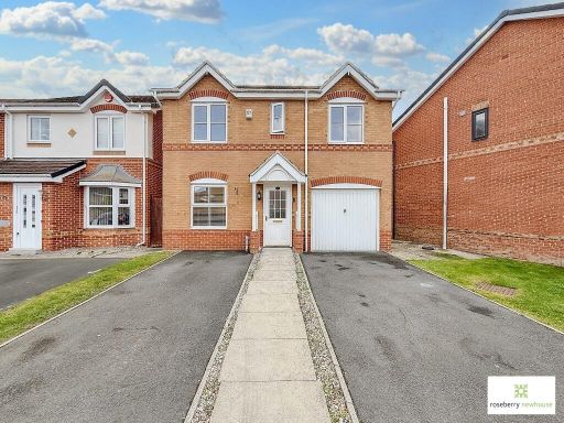 4 bedroom detached house for sale in Brough Field Close, Ingleby Barwick, TS17 — £239,950 • 4 bed • 2 bath • 849 ft²
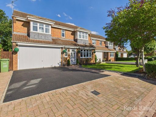 4 bedroom detached house for sale in Snowdrop Close, Stockton-on-Tees, TS19 — £325,000 • 4 bed • 2 bath • 1595 ft²
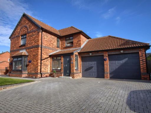 4 bedroom detached house for sale in Thorington Gardens, Ingleby Barwick, TS17 — £405,000 • 4 bed • 2 bath • 1984 ft²
Meta
- {
"@context": "https://schema.org",
"@type": "Residence",
"name": "4 bedroom detached house for sale in The Orchard, Ingleby B…",
"description": "",
"url": "https://propertypiper.co.uk/property/855af136-0cd9-4be3-af10-c955935f7033",
"image": "https://image-a.propertypiper.co.uk/1b76af9c-2d4c-4214-aae8-efbf1a61161c-1024.jpeg",
"address": {
"@type": "PostalAddress",
"streetAddress": "48 THE ORCHARD INGLEBY BARWICK STOCKTON-ON-TEES",
"postalCode": "TS17 5NA",
"addressLocality": "Stockton-on-Tees",
"addressRegion": "Stockton South",
"addressCountry": "England"
},
"geo": {
"@type": "GeoCoordinates",
"latitude": 54.5262841,
"longitude": -1.3226769
},
"numberOfRooms": 4,
"numberOfBathroomsTotal": 2,
"floorSize": {
"@type": "QuantitativeValue",
"value": 700,
"unitCode": "FTK"
},
"offers": {
"@type": "Offer",
"price": 389995,
"priceCurrency": "GBP",
"availability": "https://schema.org/InStock"
},
"additionalProperty": [
{
"@type": "PropertyValue",
"name": "Feature",
"value": "detached house"
},
{
"@type": "PropertyValue",
"name": "Feature",
"value": "modern construction"
},
{
"@type": "PropertyValue",
"name": "Feature",
"value": "bay windows"
},
{
"@type": "PropertyValue",
"name": "Feature",
"value": "two-storey"
},
{
"@type": "PropertyValue",
"name": "Feature",
"value": "brick facade"
},
{
"@type": "PropertyValue",
"name": "Feature",
"value": "garage"
},
{
"@type": "PropertyValue",
"name": "Feature",
"value": "driveway"
},
{
"@type": "PropertyValue",
"name": "Feature",
"value": "grass lawn"
},
{
"@type": "PropertyValue",
"name": "Feature",
"value": "well-maintained"
},
{
"@type": "PropertyValue",
"name": "Feature",
"value": "suburban"
},
{
"@type": "PropertyValue",
"name": "Feature",
"value": "modern"
},
{
"@type": "PropertyValue",
"name": "Feature",
"value": "suburban"
},
{
"@type": "PropertyValue",
"name": "Feature",
"value": "detached"
},
{
"@type": "PropertyValue",
"name": "Feature",
"value": "brick"
},
{
"@type": "PropertyValue",
"name": "Feature",
"value": "garden"
},
{
"@type": "PropertyValue",
"name": "Feature",
"value": "patio"
},
{
"@type": "PropertyValue",
"name": "Feature",
"value": "family home"
},
{
"@type": "PropertyValue",
"name": "Feature",
"value": "quiet neighborhood"
},
{
"@type": "PropertyValue",
"name": "Feature",
"value": "well-maintained"
}
]
}
High Res Floorplan Images
Compatible Floorplan Images
FloorplanImages Thumbnail