CM6 4DD - 2 bedroom semidetached house for sale in Woodside Way, Dunm…
View on Property Piper
2 bedroom semi-detached house for sale in Woodside Way,
Dunmow Grange,
CM6 4DD, CM6
Property Details
- Price: £374995
- Bedrooms: 2
- Bathrooms: 1
- Property Type: undefined
- Property SubType: undefined
Brochure Descriptions
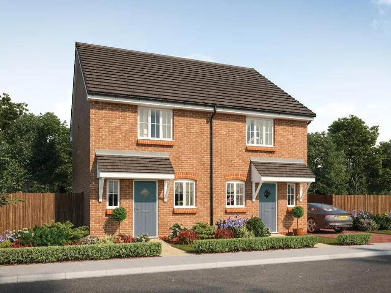
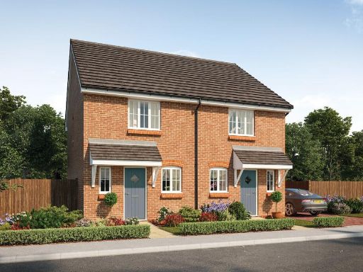
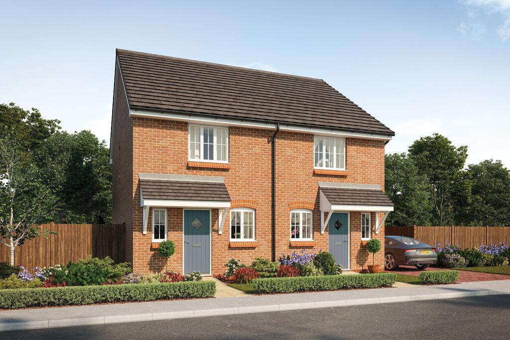
- This is a newly-built, two-bedroom semi-detached house with brick construction, as part of the Artisan Collection. The property likely includes front garden space, private parking, and a tiled pitched roof. The overall size of the property appears average for a two-bedroom modern home, with a modest but well-maintained front garden. The property is set in a suburban location with greenery and fencing visible, but no exceptional views or significant elevation change. Garden size is small to average by British standards; overall layout modern and efficient.
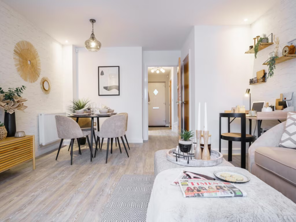
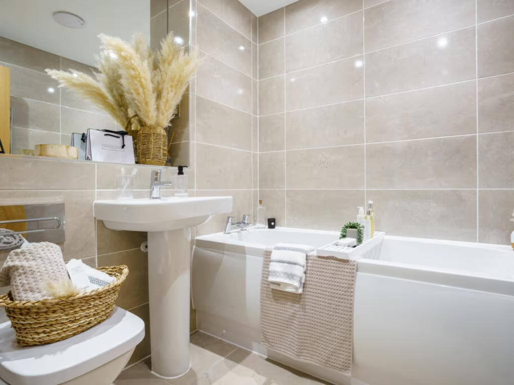
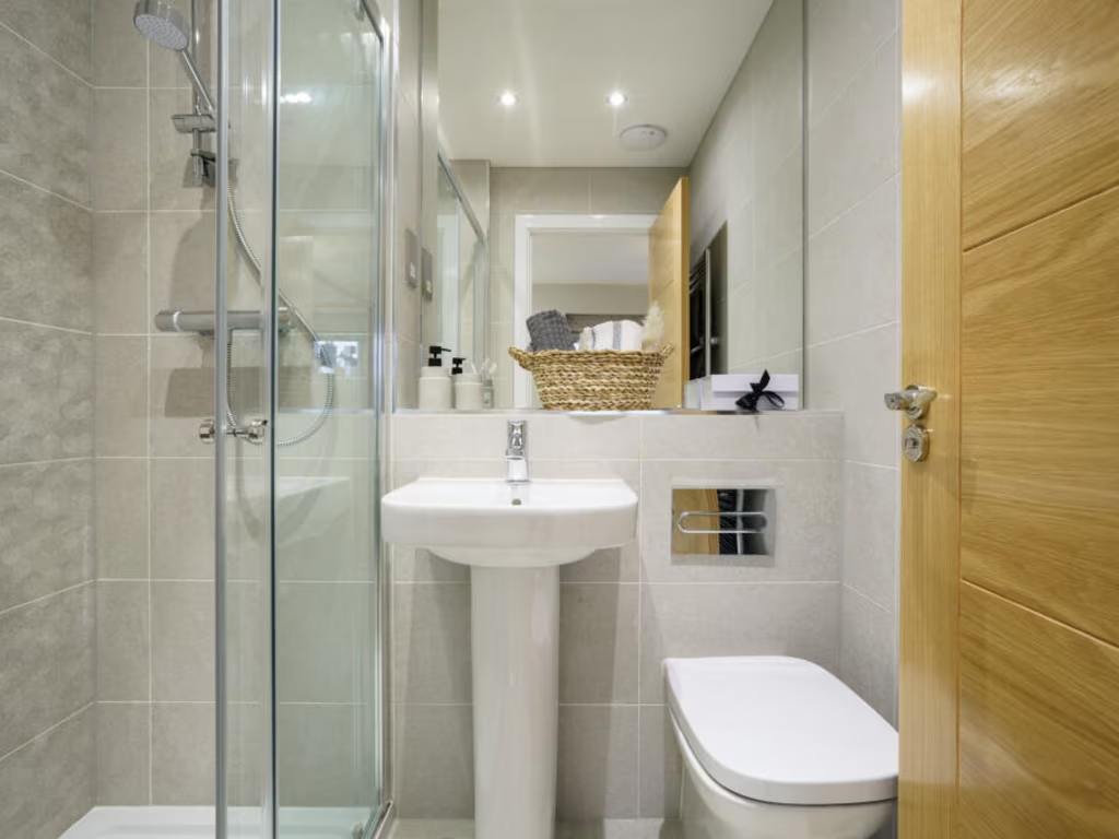
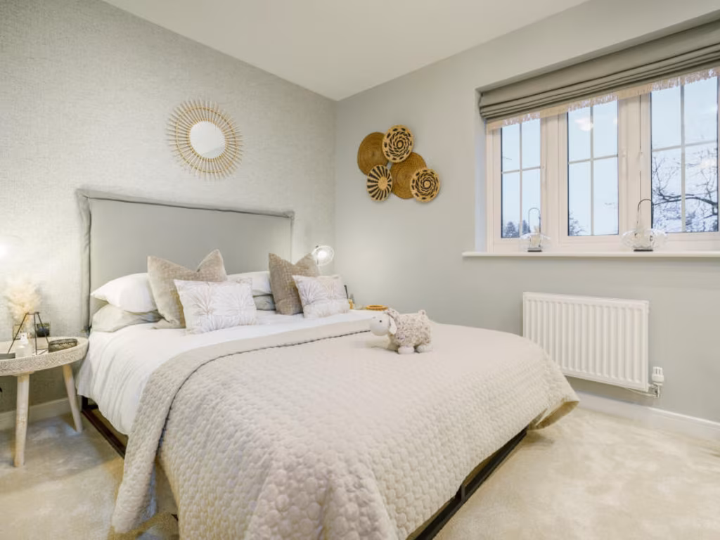
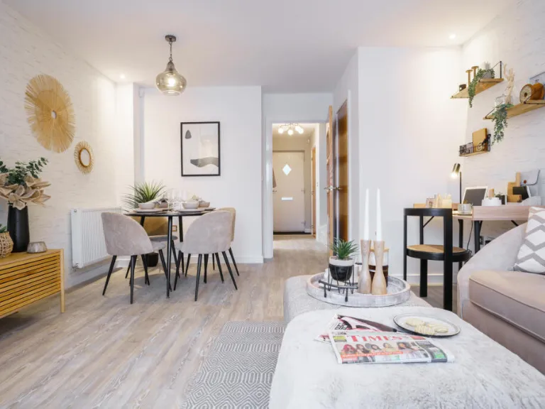
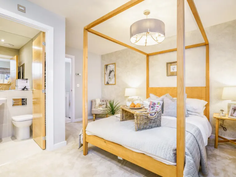
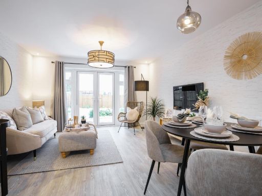
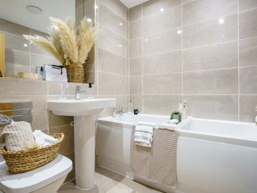
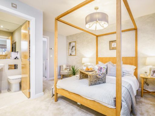
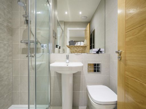
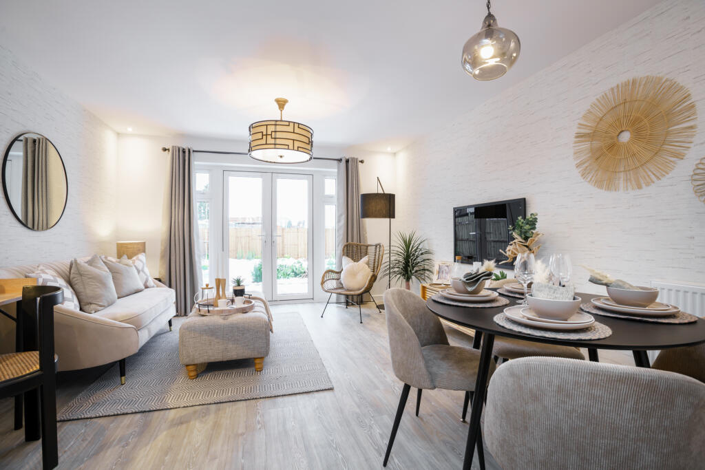
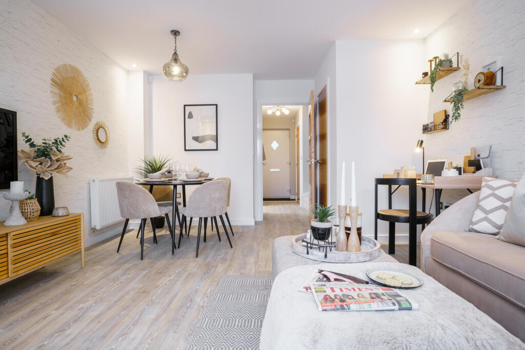
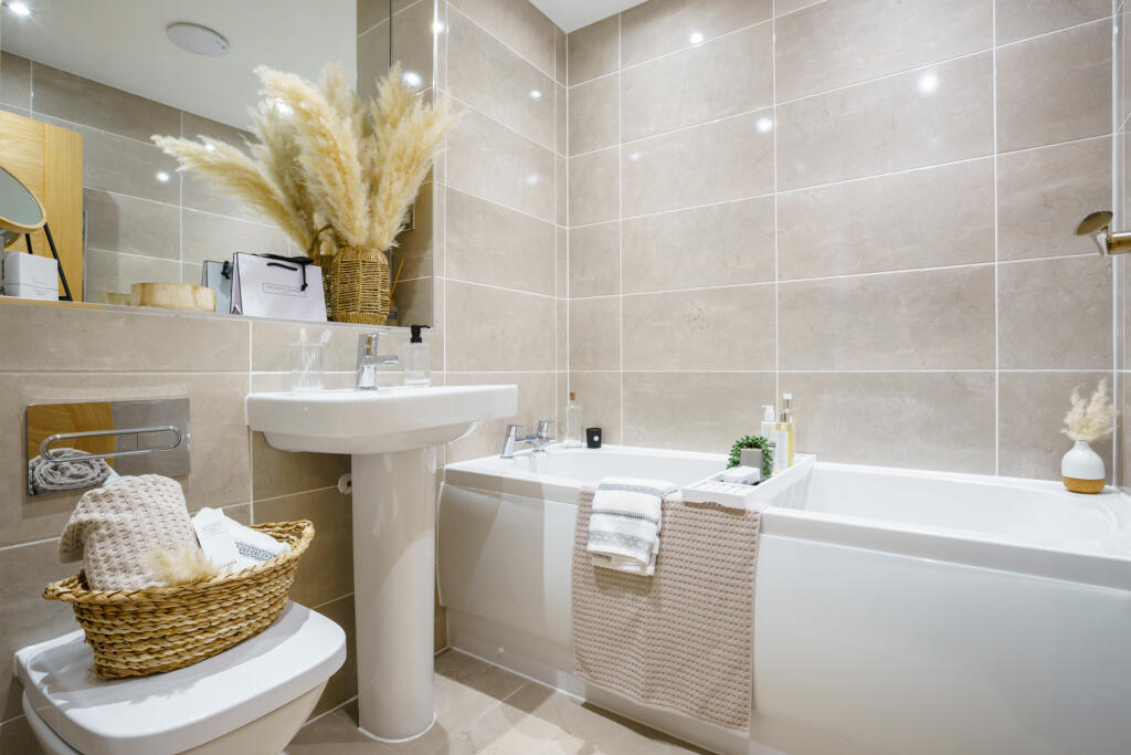
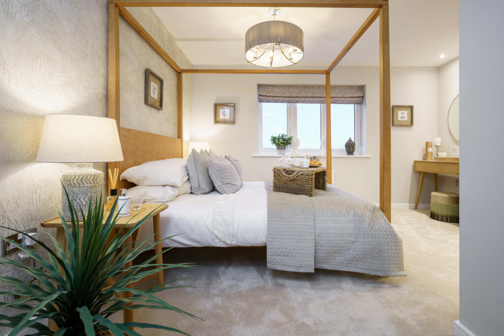
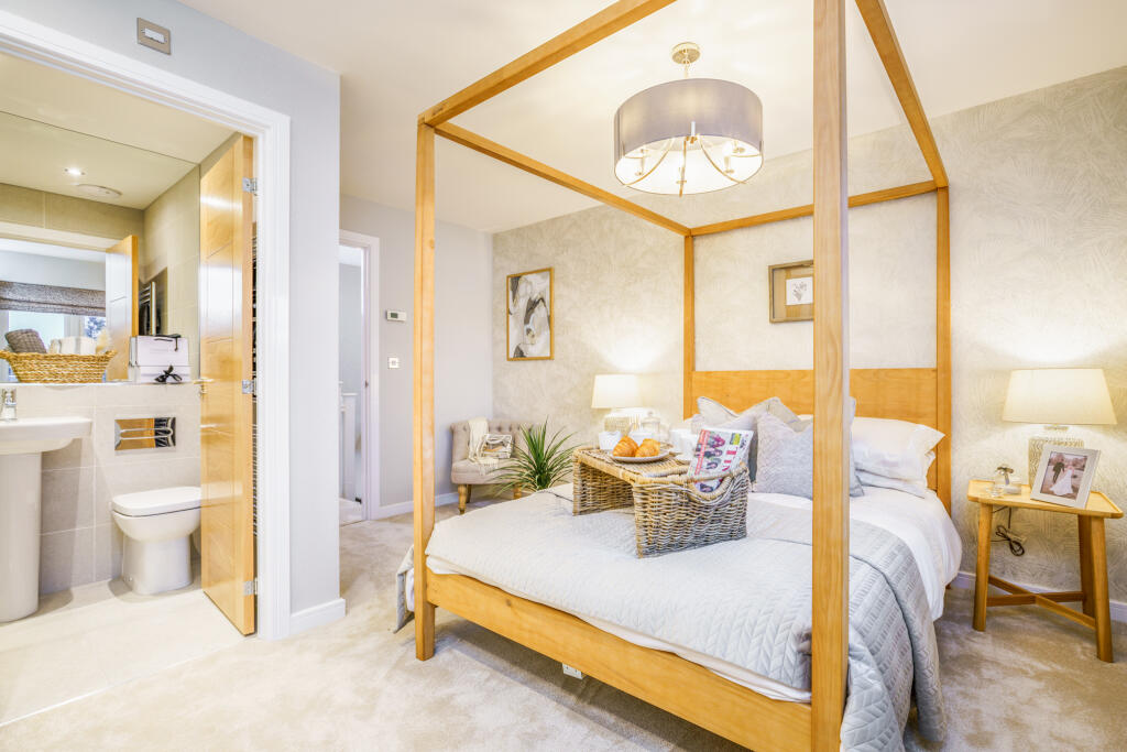
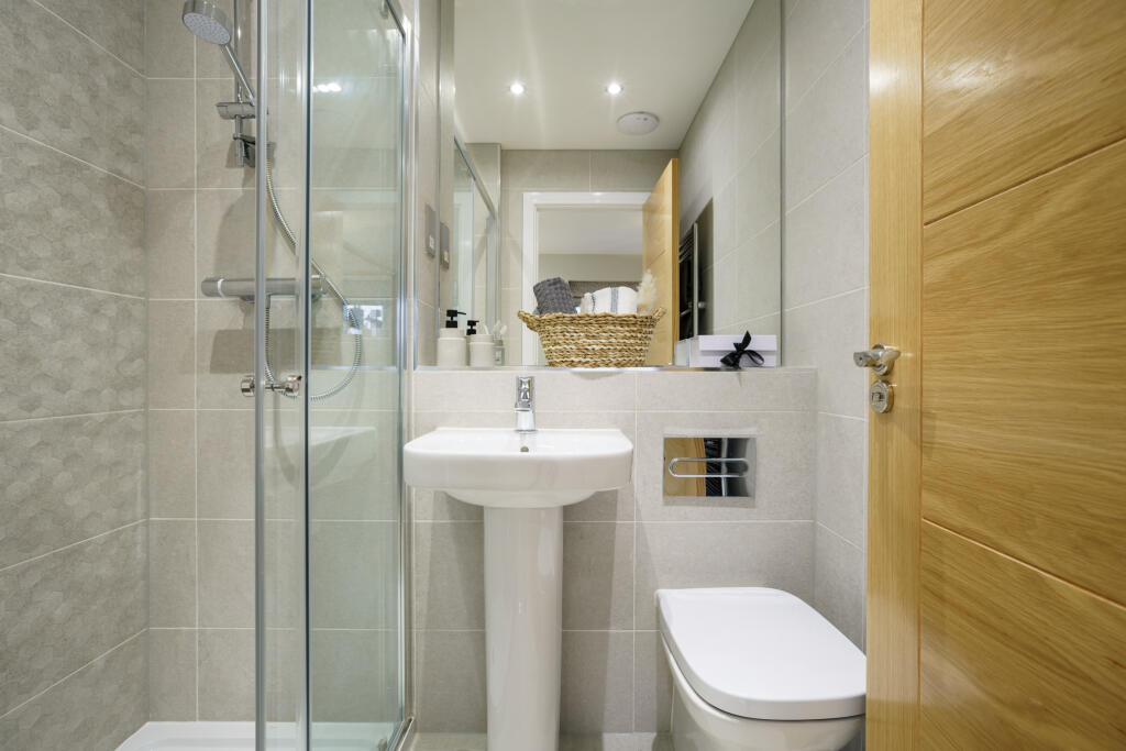
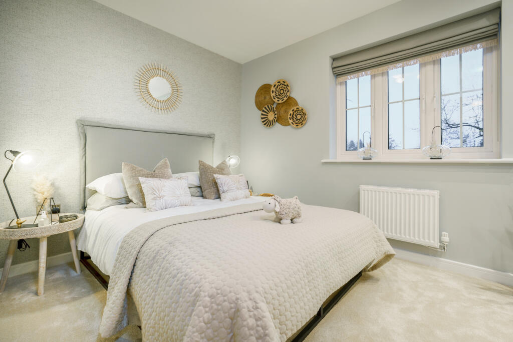
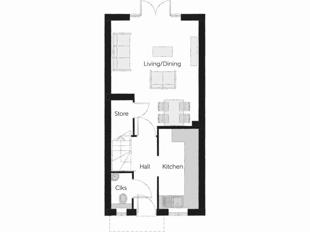
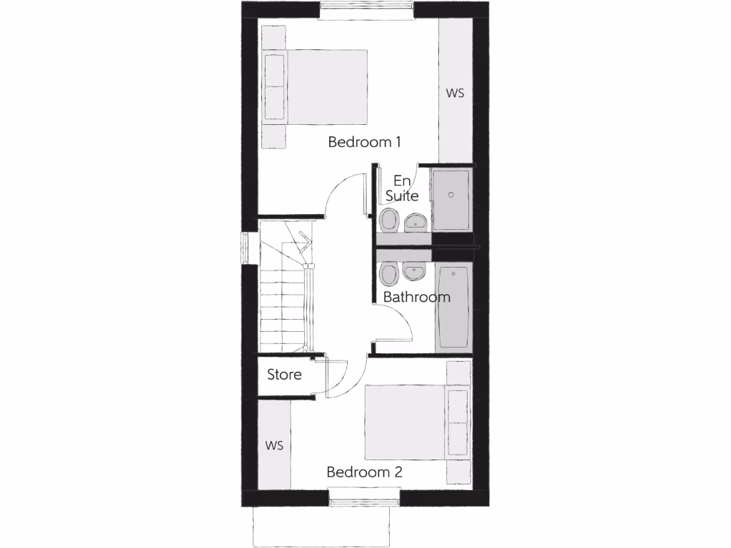
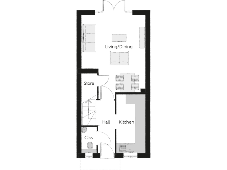
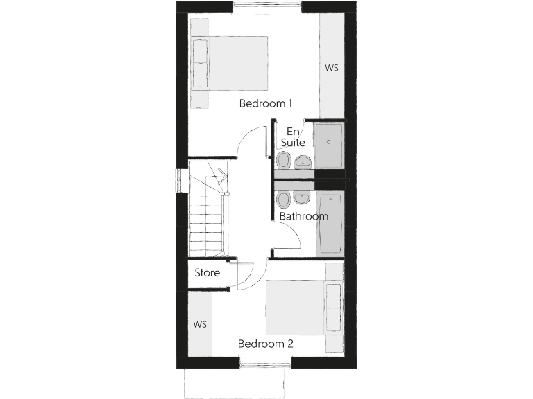
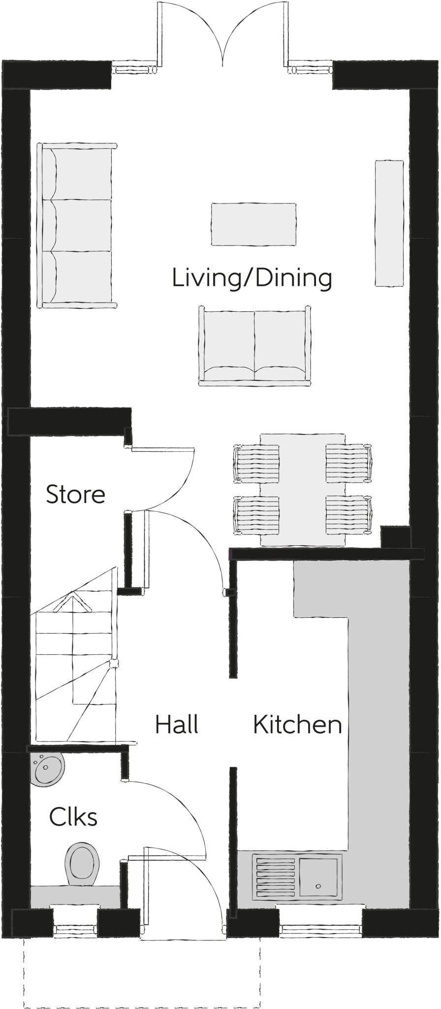
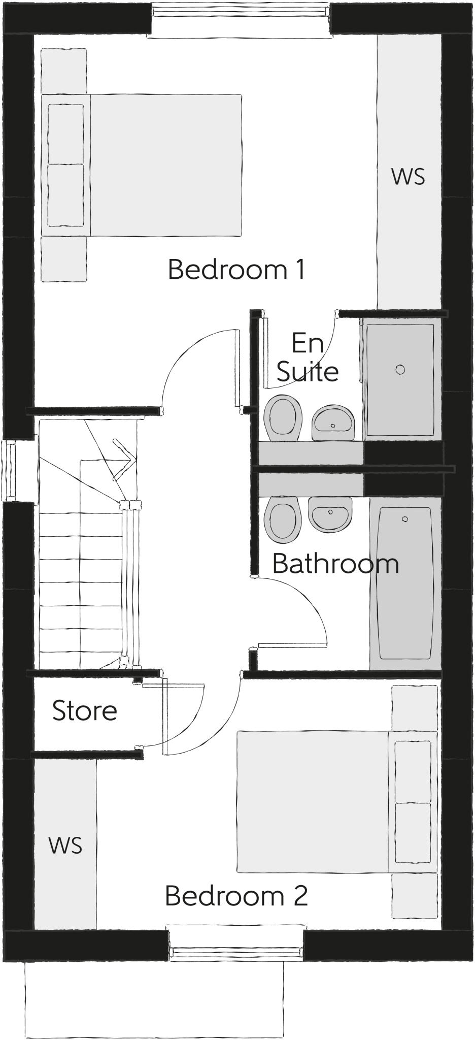
- This is a two-bedroom home called The Potter, arranged over two floors. The ground floor has a hall, kitchen, cloakroom, store, and a large open-plan living/dining area (17'6" x 13'1"). The first floor contains two bedrooms: Bedroom 1 (13'3" x 13'1") with an en suite and Bedroom 2 (13'1" x 8'1"), plus a main bathroom. There are two dedicated wardrobe spaces. Both the living/dining area and bedrooms are generously sized for a home of this type. Overall, the property can be considered average-sized for a modern two-bedroom house; the living spaces are well-proportioned and layout is efficient. No garden or external views are specified or visible from this plan.
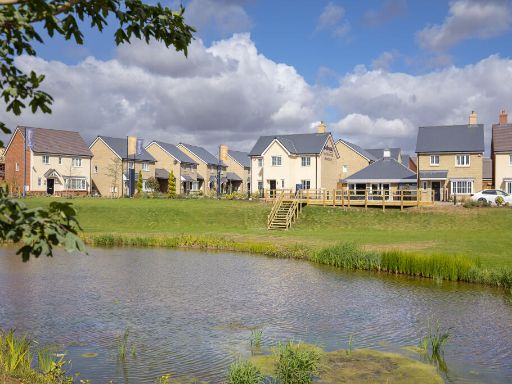
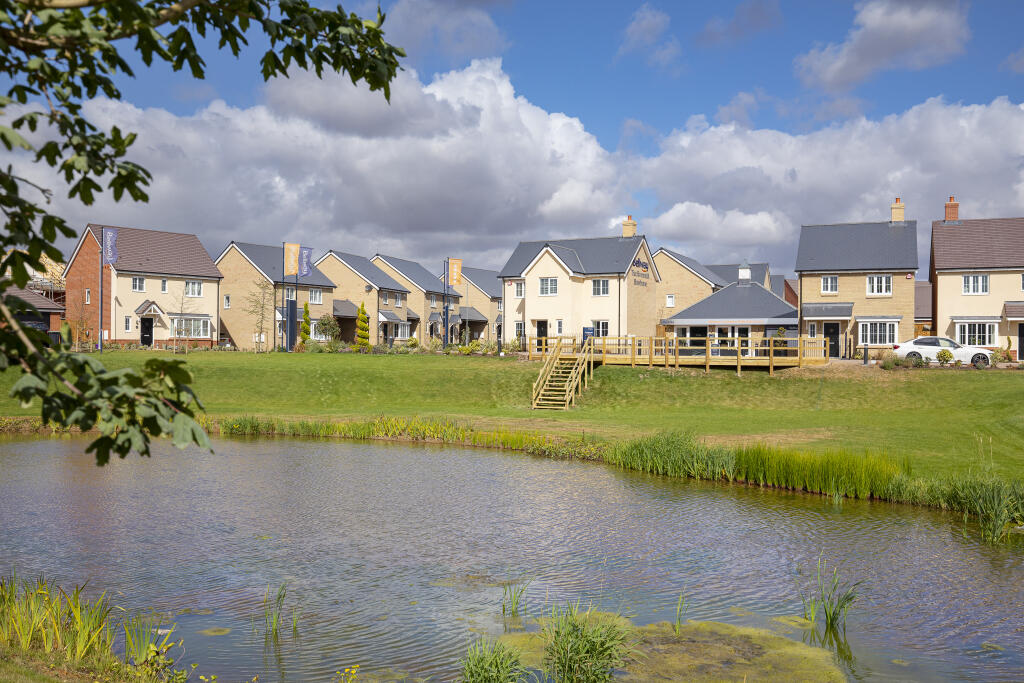
- The property listing refers to a collection of 2, 3, and 4 bedroom homes in the Sapphire Fields development at Great Dunmow Grange. The description suggests a modern residential development, likely comprised of a variety of house sizes, with houses that may suit both small and large families. This is likely a suburban or semi-rural development, potentially offering some countryside views characteristic of the Great Dunmow area. Exact plot sizes and specific garden sizes are not specified, but the presence of multiple bedroom options implies a mixture of small to large family homes within a modern build context.
- The property is located in the residential development of Sapphire Fields on Stortford Road in Great Dunmow, Essex, an area just off the A120 road, offering convenient access to regional transport links. The development is likely to consist of new-build homes. Based on the map, the location appears suburban with possible proximity to open fields or countryside, but no direct view detail is given. The site could accommodate average to large family homes with associated gardens, typical of residential developments in semi-rural Essex.
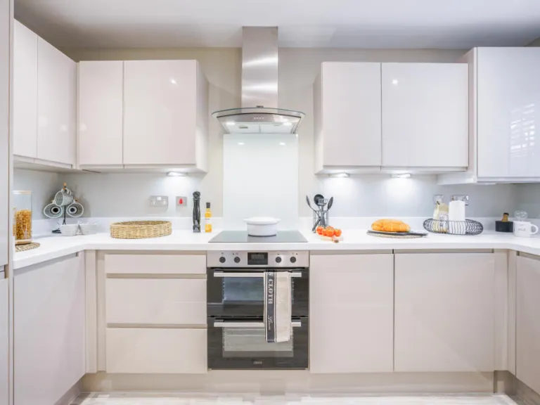
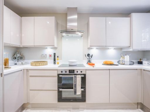
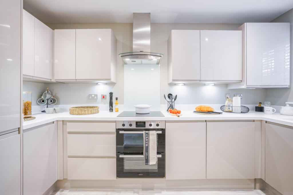
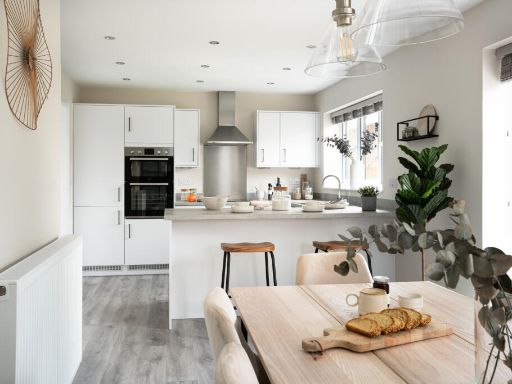
- The property appears to be part of a newly built residential development by Bellway. The image shows a modern kitchen with modern cabinetry, a central island, and integrated appliances, typical of contemporary new builds. Room appears to be of average to large size and receives ample natural light, indicative of good window placement. No exterior views or garden are shown, so overall property size and external features can't be inferred. No square footage is visible. The standard of finish visible suggests a focus on quality and modern design consistent with new build developments aimed at families or professionals.
- The image is a site plan for a new residential development. The properties are a mix of 2, 3, and 4-bedroom houses, divided into types such as "The Jeweller," "The Goldsmith," "The Bowyer," and affordable homes. The development is set around landscaped areas, a pond, and some sports facilities. The site includes a large central green with playing fields, various pockets of green space, a pond to the south, and a roundabout at the entrance. Homes are semi-detached and detached, generally arranged on small-to-medium plots. Most gardens appear small to average. The overall estate is large, designed for a suburban setting, with tree-lined roads and cul-de-sacs. No sea, river, or mountain views are evident; the outlook is of plenty of greenery and parkland.
- This listing advertises a new development, Sapphire Fields at Great Dunmow Grange, located in Great Dunmow. The development comprises a collection of 2, 3, and 4 bedroom homes, likely arranged in a suburban or semi-rural setting. No specific details on plot sizes, views, or architectural style are provided, but as a housing development by Bellway, properties are likely to be modern family homes with average to large room and garden sizes typical for this type of new build estate.
- The property for sale is located in the Sapphire Fields development on Stortford Road in Great Dunmow, Essex. No visual images of the property are provided, so its size, style, and outlook cannot be determined from this image.
- The property appears to be a newly-built home, highlighted for high standards of design and build quality. The kitchen shown in the image is modern, with contemporary cabinetry, integrated appliances, and a large countertop, suggesting an open-plan or spacious kitchen/dining area. The room size can be described as average to large, suitable for family living. The focus on light and layout indicates that the overall property size is likely average to generous for a modern family home. No external views or garden spaces are visible in the image, so surroundings cannot be assessed.
Image Descriptions
- living/dining room modern
- semi-detached house contemporary
Floorplan Description
- A floorplan with Living/Dining area, Kitchen, a Store room, Hall, and Cloakroom
Rooms
- Living/Dining:
- Store:
- Hall:
- Kitchen:
- Clks:
- Bedroom 1:
- En Suite:
- Bathroom:
- Bedroom 2:
Textual Property Features
- Is New Build
- Has Garden
- Chain Free
- Success
Detected Visual Features
- modern
- open-plan
- living room
- dining room
- French doors
- natural light
- wood flooring
- contemporary
- bright
- family home
- semi-detached
- new build
- brick
- two-storey
- front garden
- driveway
- sloped roof
Nearby Schools
- Great Dunmow Primary School
- St Mary's Church of England Voluntary Aided Primary School, Hatfield Broad Oak
- Felsted Primary School
- Takeley Primary School
- Roseacres Primary School
- Ford End Church of England Primary School
- Dunmow St Mary's Primary School
- Great Easton Church of England Voluntary Aided Primary School
- The Flitch Green Academy
- Felsted School
- Helena Romanes School
- Stebbing Primary School
- Elsenham Church of England Voluntary Controlled Primary School
- Henham and Ugley Primary and Nursery School
Nearest Bars And Restaurants
- Id: 3976298084
- Tags:
- Amenity: restaurant
- Name: Rhubarb
- Source: Bing/Knowledge
- TagsNormalized:
- Lat: 51.872499
- Lon: 0.3625537
- FullGeoHash: u10r07050net
- PartitionGeoHash: u10r
- Images:
- FoodStandards: null
- Distance: 1522.4
,- Id: 611380112
- Tags:
- Amenity: fast_food
- Cuisine: chinese
- Name: Jade Garden
- TagsNormalized:
- Lat: 51.873271
- Lon: 0.3622693
- FullGeoHash: u10r05pz9qxd
- PartitionGeoHash: u10r
- Images:
- FoodStandards: null
- Distance: 1507.5
,- Id: 611380103
- Tags:
- Amenity: restaurant
- Name: The Starr
- TagsNormalized:
- Lat: 51.8735691
- Lon: 0.3620392
- FullGeoHash: u10r05r9kn5u
- PartitionGeoHash: u10r
- Images:
- FoodStandards: null
- Distance: 1494.9
,- Id: 1052127316
- Tags:
- Addr:
- City: Great Dunmow
- Housenumber: 27
- Postcode: CM6 1DA
- Street: Stortford Road
- Amenity: pub
- Building: yes
- Name: The Chequers
- Wikidata: Q26305695
- TagsNormalized:
- Lat: 51.8728532
- Lon: 0.3606953
- FullGeoHash: u10r05ntkb9y
- PartitionGeoHash: u10r
- Images:
- FoodStandards: null
- Distance: 1396.5
,- Id: 611380132
- Tags:
- Alt_name: Jalsa Ghar
- Amenity: restaurant
- Cuisine: Bangladeshi; Indian
- Name: Queen Victoria
- TagsNormalized:
- restaurant
- bangladeshi
- indian
- Lat: 51.8719533
- Lon: 0.3543388
- FullGeoHash: u10r054008yn
- PartitionGeoHash: u10r
- Images:
- FoodStandards: null
- Distance: 958.2
}
Nearest General Shops
- Id: 2725329675
- Tags:
- Addr:
- Postcode: CM6 1TD
- Street: High Cross Lane
- Name: Langthorns Plantery
- Opening_hours: Mo-Su 10:00-17:00
- Shop: garden_centre
- Website: https://langthorns.com/
- TagsNormalized:
- Lat: 51.8613371
- Lon: 0.3089853
- FullGeoHash: u10pp10fpvun
- PartitionGeoHash: u10p
- Images:
- FoodStandards: null
- Distance: 2468.7
,- Id: 533674213
- Tags:
- TagsNormalized:
- Lat: 51.8805785
- Lon: 0.3660478
- FullGeoHash: u10r0kdd38c1
- PartitionGeoHash: u10r
- Images:
- FoodStandards: null
- Distance: 1995.4
,- Id: 533673984
- Tags:
- Building: yes
- Name: Flitch Bikes
- Shop: bicycle
- TagsNormalized:
- Lat: 51.875544
- Lon: 0.3625048
- FullGeoHash: u10r05xuyyr1
- PartitionGeoHash: u10r
- Images:
- FoodStandards: null
- Distance: 1564.7
}
Nearest Grocery shops
- Id: 266166662
- Tags:
- Addr:
- City: Takeley
- Postcode: CM22 6SH
- Street: Brewers End
- Building: yes
- Name: Post Office Stores
- Opening_hours: Mo-Sa 08:00-18:00; Su 09:00-14:00
- Shop: convenience
- TagsNormalized:
- post office
- convenience
- shop
- Lat: 51.8679138
- Lon: 0.2672237
- FullGeoHash: u10pn4686zbm
- PartitionGeoHash: u10p
- Images:
- FoodStandards: null
- Distance: 5045.2
,- Id: 611360859
- Tags:
- Brand: One Stop
- Brand:wikidata: Q65954217
- Name: One Stop
- Shop: convenience
- TagsNormalized:
- Lat: 51.8701924
- Lon: 0.3653893
- FullGeoHash: u10r06djf0wj
- PartitionGeoHash: u10r
- Images:
- FoodStandards: null
- Distance: 1730.4
,- Id: 1050875118
- Tags:
- Brand: Tesco
- Brand:wikidata: Q487494
- Brand:wikipedia: en:Tesco
- Building: yes
- Name: Tesco
- Note: Petrol station shop attached to larger store.
- Operator: Tesco
- Shop: convenience
- Website: https://www.tesco.com/store-locator/dunmow/stortford-rd
- TagsNormalized:
- Lat: 51.8729637
- Lon: 0.3449476
- FullGeoHash: u10ppg5jvv79
- PartitionGeoHash: u10p
- Images:
- FoodStandards: null
- Distance: 326
}
Nearest Supermarkets
- Id: 2725318202
- Tags:
- Brand: Tesco Express
- Brand:wikidata: Q98456772
- Contact:
- Website: https://www.tesco.com/store-locator/dunmow/1-priors-green-local-centre
- Name: Priors Green Supermarket (Tesco Express)
- Opening_hours: 07:00-23:00
- Operator: Tesco
- Shop: supermarket
- TagsNormalized:
- tesco
- tesco express
- supermarket
- shop
- Lat: 51.8701024
- Lon: 0.281741
- FullGeoHash: u10pn6tjjpcm
- PartitionGeoHash: u10p
- Images:
- FoodStandards: null
- Distance: 4032.7
,- Id: 285675101
- Tags:
- Addr:
- City: Great Dunmow
- Postcode: CM6 1BD
- Street: White Street
- Alt_name: The Co-operative Food
- Brand: Co-op Food
- Brand:wikidata: Q3277439
- Brand:wikipedia: en:Co-op Food
- Building: yes
- Name: Co-op Food
- Operator: The Co-operative Group
- Operator:wikidata: Q117202
- Shop: supermarket
- TagsNormalized:
- co-op
- co-op food
- food
- supermarket
- shop
- Lat: 51.872224
- Lon: 0.3639644
- FullGeoHash: u10r07118grs
- PartitionGeoHash: u10r
- Images:
- FoodStandards: null
- Distance: 1618.8
,- Id: 274094156
- Tags:
- Addr:
- City: Great Dunmow
- Postcode: CM6 1SF
- Street: Stortford Road
- Alt_name: Tesco Dunmow Superstore
- Brand: Tesco
- Brand:wikidata: Q487494
- Brand:wikipedia: en:Tesco
- Building: retail
- Layer: -1
- Name: Tesco
- Opening_hours: Mo-Sa 06:00-24:00; Su 10:00-16:00
- Operator: Tesco Stores Ltd
- Shop: supermarket
- Website: https://www.tesco.com/store-locator/dunmow/stortford-rd
- Wheelchair: yes
- TagsNormalized:
- tesco
- retail
- supermarket
- shop
- Lat: 51.8730877
- Lon: 0.3471835
- FullGeoHash: u10ppghy9uqv
- PartitionGeoHash: u10p
- Images:
- FoodStandards: null
- Distance: 478.2
}
Nearest Religious buildings
- Id: 595211700
- Tags:
- Addr:
- City: Great Dunmow
- County: Essex
- Postcode: CM6 1BH
- Street: New Street
- Amenity: place_of_worship
- Building: yes
- Denomination: united_reformed
- Name: United Reformed Church
- Religion: christian
- Source: OS OpenMap Local;web search
- TagsNormalized:
- place of worship
- united reformed
- church
- christian
- Lat: 51.8698323
- Lon: 0.3637344
- FullGeoHash: u10r068gets1
- PartitionGeoHash: u10r
- Images:
- FoodStandards: null
- Distance: 1623.6
,- Id: 611113349
- Tags:
- Amenity: place_of_worship
- Denomination: Society of Friends
- Name: Friends' Meeting House
- Religion: christian
- TagsNormalized:
- place of worship
- christian
- church
- Lat: 51.8691624
- Lon: 0.3631025
- FullGeoHash: u10r062rubsv
- PartitionGeoHash: u10r
- Images:
- FoodStandards: null
- Distance: 1594.6
,- Id: 611113354
- Tags:
- Amenity: place_of_worship
- Denomination: baptist
- Name: The Ark Baptist Chapel
- Religion: christian
- TagsNormalized:
- place of worship
- baptist
- chapel
- christian
- church
- Lat: 51.871841
- Lon: 0.3625972
- FullGeoHash: u10r06bp3hh0
- PartitionGeoHash: u10r
- Images:
- FoodStandards: null
- Distance: 1525.3
}
Nearest Medical buildings
- Id: 611452789
- Tags:
- Amenity: pharmacy
- Healthcare: pharmacy
- Name: Ropers
- TagsNormalized:
- Lat: 51.8727187
- Lon: 0.3625918
- FullGeoHash: u10r070h3p85
- PartitionGeoHash: u10r
- Images:
- FoodStandards: null
- Distance: 1525.8
,- Id: 48076432
- Tags:
- Name: Doctor's Pond
- Natural: water
- Water: pond
- TagsNormalized:
- Lat: 51.8745262
- Lon: 0.3620341
- FullGeoHash: u10r05rxh084
- PartitionGeoHash: u10r
- Images:
- FoodStandards: null
- Distance: 1509.5
,- Id: 611453079
- Tags:
- Amenity: doctors
- Healthcare: doctor
- Name: Angel Lane Surgery
- TagsNormalized:
- doctor
- doctors
- health
- healthcare
- surgery
- Lat: 51.8714998
- Lon: 0.3621304
- FullGeoHash: u10r04ztqhru
- PartitionGeoHash: u10r
- Images:
- FoodStandards: null
- Distance: 1494.6
,- Id: 1134695571
- Tags:
- Amenity: pharmacy
- Healthcare: pharmacy
- Name: Yogi Pharmacy
- TagsNormalized:
- Lat: 51.8731717
- Lon: 0.3619816
- FullGeoHash: u10r05px4u14
- PartitionGeoHash: u10r
- Images:
- FoodStandards: null
- Distance: 1486.9
}
Nearest Airports
- Id: 495488524
- Tags:
- Aerodrome: international
- Aerodrome:type: public
- Aeroway: aerodrome
- Alt_name: Stansted
- Iata: STN
- Icao: EGSS
- Is_in: Essex,England,UK
- Name: London Stansted Airport
- Ref: STN
- Source: Gagravarr_Airports
- Website: https://www.stanstedairport.com/
- Wikidata: Q8709
- Wikipedia: en:London Stansted Airport
- TagsNormalized:
- airport
- international airport
- Lat: 51.8869677
- Lon: 0.2429264
- FullGeoHash: u10pjt8zkxg4
- PartitionGeoHash: u10p
- Images:
- FoodStandards: null
- Distance: 6889.8
}
Nearest Leisure Facilities
- Id: 8130363121
- Tags:
- TagsNormalized:
- picnic
- picnic table
- leisure
- Lat: 51.8659369
- Lon: 0.3374345
- FullGeoHash: u10pp9vsyz3k
- PartitionGeoHash: u10p
- Images:
- FoodStandards: null
- Distance: 720
,- Id: 8130363120
- Tags:
- TagsNormalized:
- picnic
- picnic table
- leisure
- Lat: 51.8659526
- Lon: 0.3374647
- FullGeoHash: u10pp9vtp6rf
- PartitionGeoHash: u10p
- Images:
- FoodStandards: null
- Distance: 717.8
,- Id: 920580164
- Tags:
- Access: private
- Leisure: swimming_pool
- TagsNormalized:
- swimming
- swimming pool
- pool
- leisure
- Lat: 51.8727281
- Lon: 0.3501252
- FullGeoHash: u10ppgnuw92k
- PartitionGeoHash: u10p
- Images:
- FoodStandards: null
- Distance: 671.7
,- Id: 938215181
- Tags:
- TagsNormalized:
- Lat: 51.8756849
- Lon: 0.3480931
- FullGeoHash: u10ppgtmz0t4
- PartitionGeoHash: u10p
- Images:
- FoodStandards: null
- Distance: 659.1
,- Id: 919710551
- Tags:
- TagsNormalized:
- swimming
- swimming pool
- pool
- leisure
- Lat: 51.872029
- Lon: 0.3477162
- FullGeoHash: u10ppgj0qr5c
- PartitionGeoHash: u10p
- Images:
- FoodStandards: null
- Distance: 503.4
}
Nearest Tourist attractions
- Id: 1193131902
- Tags:
- TagsNormalized:
- Lat: 51.8773284
- Lon: 0.3674019
- FullGeoHash: u10r07gx34ft
- PartitionGeoHash: u10r
- Images:
- FoodStandards: null
- Distance: 1941.9
,- Id: 1628775292
- Tags:
- TagsNormalized:
- Lat: 51.8740169
- Lon: 0.3681766
- FullGeoHash: u10r07kh51sk
- PartitionGeoHash: u10r
- Images:
- FoodStandards: null
- Distance: 1919.1
,- Id: 611113373
- Tags:
- Name: Dunmow Maltings
- Tourism: museum
- Website: https://www.greatdunmowmaltings.uk/
- Wikidata: Q17534714
- TagsNormalized:
- Lat: 51.8730736
- Lon: 0.3644237
- FullGeoHash: u10r071qe9y1
- PartitionGeoHash: u10r
- Images:
- FoodStandards: null
- Distance: 1653.4
}
Nearest Train stations
- Id: 5906356206
- Tags:
- Light_rail: yes
- Name: Terminal C
- Network: Stansted Airport Terminal Link
- Public_transport: station
- Railway: station
- Station: light_rail
- TagsNormalized:
- Lat: 51.8892206
- Lon: 0.2541483
- FullGeoHash: u10pjy1hd5f9
- PartitionGeoHash: u10p
- Images:
- FoodStandards: null
- Distance: 6216.3
,- Id: 5906356207
- Tags:
- Light_rail: yes
- Name: Terminal B
- Network: Stansted Airport Terminal Link
- Public_transport: station
- Railway: station
- Station: light_rail
- TagsNormalized:
- Lat: 51.8911228
- Lon: 0.2569959
- FullGeoHash: u10pjy7psqqh
- PartitionGeoHash: u10p
- Images:
- FoodStandards: null
- Distance: 6100.2
,- Id: 5906352887
- Tags:
- Level: 1
- Light_rail: yes
- Name: Main Terminal Building (Departures)
- Network: Stansted Airport Terminal Link
- Public_transport: station
- Railway: station
- Station: light_rail
- Wheelchair: yes
- TagsNormalized:
- Lat: 51.8902434
- Lon: 0.2601274
- FullGeoHash: u10pjym6t6mn
- PartitionGeoHash: u10p
- Images:
- FoodStandards: null
- Distance: 5864.8
,- Id: 6432356094
- Tags:
- Building:
- Level: 1
- Light_rail: yes
- Name: Main Terminal Building (Arrivals)
- Network: Stansted Airport Terminal Link
- Public_transport: station
- Railway: station
- Station: light_rail
- Wheelchair: yes
- TagsNormalized:
- Lat: 51.8911955
- Lon: 0.2615497
- FullGeoHash: u10pjyw2necw
- PartitionGeoHash: u10p
- Images:
- FoodStandards: null
- Distance: 5810.9
,- Id: 6137852415
- Tags:
- Name: Stansted Airport
- Naptan:
- Network: National Rail
- Public_transport: station
- Railway: station
- Ref:
- Wikidata: Q2652717
- Wikipedia: en:Stansted Airport railway station
- TagsNormalized:
- Lat: 51.8892596
- Lon: 0.2621537
- FullGeoHash: u10pjynuue5f
- PartitionGeoHash: u10p
- Images:
- FoodStandards: null
- Distance: 5697
}
Nearest Hotels
- Id: 533672901
- Tags:
- Addr:
- City: Dunmow
- Postcode: CM6 1LW
- Street: Chelmsford Road
- Alt_name: Travelodge Great Dunmow
- Branch: Great Dunmow
- Brand: Travelodge
- Brand:wikidata: Q9361374
- Brand:wikipedia: en:Travelodge UK
- Building: yes
- Fhrs:
- Authority: Uttlesford
- Id: 118671
- Local_authority_id: 48013999100
- Internet_access: wlan
- Internet_access:fee: customers
- Internet_access:ssid: Travelodge WiFi
- Name: Travelodge
- Operator: Travelodge Hotels Ltd
- Tourism: hotel
- TagsNormalized:
- Lat: 51.8608876
- Lon: 0.3743392
- FullGeoHash: u10r08bxddps
- PartitionGeoHash: u10r
- Images:
- FoodStandards: null
- Distance: 2646.4
,- Id: 611380186
- Tags:
- Amenity: pub;restaurant
- Name: Saracen's Head
- Tourism: hotel
- TagsNormalized:
- bar
- pub
- restaurant
- hotel
- tourism
- Lat: 51.8726285
- Lon: 0.3622618
- FullGeoHash: u10r05pgcqcc
- PartitionGeoHash: u10r
- Images:
- FoodStandards: null
- Distance: 1502.8
,- Id: 1240412962
- Tags:
- Name: The Saracen's Head
- Tourism: hotel
- TagsNormalized:
- Lat: 51.8726917
- Lon: 0.3621252
- FullGeoHash: u10r05psq4s4
- PartitionGeoHash: u10r
- Images:
- FoodStandards: null
- Distance: 1493.7
}
Tags
- modern
- open-plan
- living room
- dining room
- French doors
- natural light
- wood flooring
- contemporary
- bright
- family home
- semi-detached
- contemporary
- new build
- brick
- two-storey
- front garden
- driveway
- sloped roof
Similar Properties
 4 bedroom detached house for sale in Woodside Way,
Dunmow Grange,
CM6 4DD, CM6 — £609,995 • 4 bed • 1 bath • 1494 ft²
4 bedroom detached house for sale in Woodside Way,
Dunmow Grange,
CM6 4DD, CM6 — £609,995 • 4 bed • 1 bath • 1494 ft²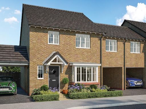 3 bedroom link detached house for sale in Woodside Way,
Dunmow Grange,
CM6 4DD, CM6 — £464,995 • 3 bed • 1 bath • 1101 ft²
3 bedroom link detached house for sale in Woodside Way,
Dunmow Grange,
CM6 4DD, CM6 — £464,995 • 3 bed • 1 bath • 1101 ft² 4 bedroom detached house for sale in Woodside Way,
Dunmow Grange,
CM6 4DD, CM6 — £699,995 • 4 bed • 1 bath • 1713 ft²
4 bedroom detached house for sale in Woodside Way,
Dunmow Grange,
CM6 4DD, CM6 — £699,995 • 4 bed • 1 bath • 1713 ft²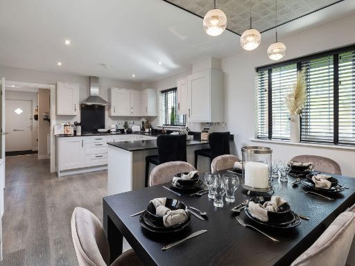 4 bedroom detached house for sale in Woodside Way,
Dunmow Grange,
CM6 4DD, CM6 — £594,995 • 4 bed • 1 bath • 1214 ft²
4 bedroom detached house for sale in Woodside Way,
Dunmow Grange,
CM6 4DD, CM6 — £594,995 • 4 bed • 1 bath • 1214 ft²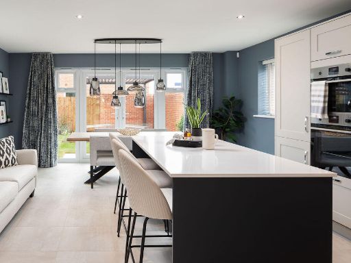 4 bedroom detached house for sale in Woodside Way,
Dunmow Grange,
CM6 4DD, CM6 — £674,995 • 4 bed • 1 bath • 1713 ft²
4 bedroom detached house for sale in Woodside Way,
Dunmow Grange,
CM6 4DD, CM6 — £674,995 • 4 bed • 1 bath • 1713 ft² 4 bedroom detached house for sale in Woodside Way,
Dunmow Grange,
CM6 4DD, CM6 — £599,995 • 4 bed • 1 bath • 1494 ft²
4 bedroom detached house for sale in Woodside Way,
Dunmow Grange,
CM6 4DD, CM6 — £599,995 • 4 bed • 1 bath • 1494 ft²
Meta
- {
"@context": "https://schema.org",
"@type": "Residence",
"name": "2 bedroom semidetached house for sale in Woodside Way, Dunm…",
"description": "",
"url": "https://propertypiper.co.uk/property/828389ac-e3e0-4644-aa25-8d94c1ae74d5",
"image": "https://image-a.propertypiper.co.uk/6208a9dc-e499-4bc8-9512-363fae60707d-1024.jpeg",
"address": {
"@type": "PostalAddress",
"streetAddress": "5 PINCEY BROOK DRIVE DUNMOW",
"postalCode": "CM6 4DD",
"addressLocality": "Uttlesford",
"addressRegion": "Saffron Walden",
"addressCountry": "England"
},
"geo": {
"@type": "GeoCoordinates",
"latitude": 51.87215032984848,
"longitude": 0.3403861126708238
},
"numberOfRooms": 2,
"numberOfBathroomsTotal": 1,
"floorSize": {
"@type": "QuantitativeValue",
"value": 755,
"unitCode": "FTK"
},
"offers": {
"@type": "Offer",
"price": 374995,
"priceCurrency": "GBP",
"availability": "https://schema.org/InStock"
},
"additionalProperty": [
{
"@type": "PropertyValue",
"name": "Feature",
"value": "modern"
},
{
"@type": "PropertyValue",
"name": "Feature",
"value": "open-plan"
},
{
"@type": "PropertyValue",
"name": "Feature",
"value": "living room"
},
{
"@type": "PropertyValue",
"name": "Feature",
"value": "dining room"
},
{
"@type": "PropertyValue",
"name": "Feature",
"value": "French doors"
},
{
"@type": "PropertyValue",
"name": "Feature",
"value": "natural light"
},
{
"@type": "PropertyValue",
"name": "Feature",
"value": "wood flooring"
},
{
"@type": "PropertyValue",
"name": "Feature",
"value": "contemporary"
},
{
"@type": "PropertyValue",
"name": "Feature",
"value": "bright"
},
{
"@type": "PropertyValue",
"name": "Feature",
"value": "family home"
},
{
"@type": "PropertyValue",
"name": "Feature",
"value": "semi-detached"
},
{
"@type": "PropertyValue",
"name": "Feature",
"value": "contemporary"
},
{
"@type": "PropertyValue",
"name": "Feature",
"value": "new build"
},
{
"@type": "PropertyValue",
"name": "Feature",
"value": "brick"
},
{
"@type": "PropertyValue",
"name": "Feature",
"value": "two-storey"
},
{
"@type": "PropertyValue",
"name": "Feature",
"value": "front garden"
},
{
"@type": "PropertyValue",
"name": "Feature",
"value": "driveway"
},
{
"@type": "PropertyValue",
"name": "Feature",
"value": "sloped roof"
}
]
}
High Res Floorplan Images
Compatible Floorplan Images
FloorplanImages Thumbnail