RG2 9LN - 4 bedroom end of terrace house for sale in Arborfield, Berk…
View on Property Piper
4 bedroom end of terrace house for sale in Arborfield,
Berkshire,
RG2 9LN, RG2
Property Details
- Price: £550000
- Bedrooms: 4
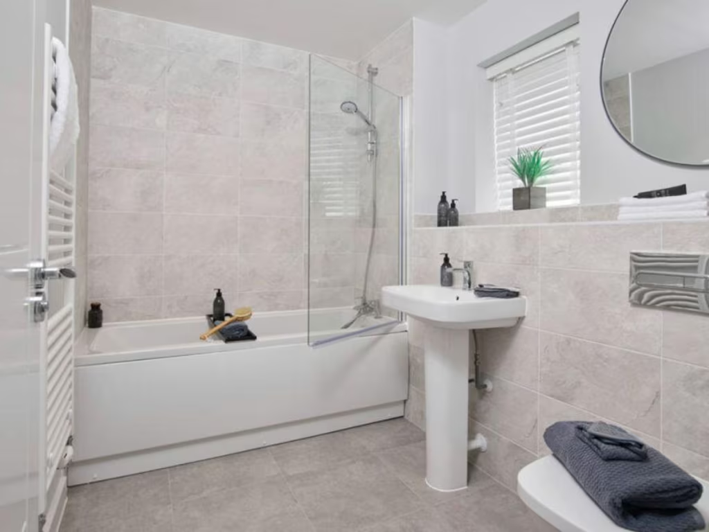
- Bathrooms: 1
- Property Type: undefined
- Property SubType: undefined
Brochure Descriptions
- Promotional brochure for a residential development called Newlands Place by Crest Nicholson. The scheme is described as a mix of 2-bedroom apartments and 3, 4 and 5-bedroom houses set in a landscaped suburban setting. Imagery suggests generous communal green space or parkland with mature trees and open grassed areas, indicating pleasant outlooks and potential family-friendly outdoor amenity. Based on the brochure content the development appears medium-to-large in overall scale; individual garden sizes cannot be determined from the image, but the presence of open parkland implies at least average to large private gardens for houses and communal grounds for apartments. No internal layout, room dimensions or total floor area are provided in the image.
- Brochure cover for a new-build development titled "Newlands Place" marketed by Crest Nicholson. This appears to be a development pack rather than an individual house listing — likely multiple new-build dwellings on a single site. No specific residential address or plot number is legible on the image. The property is presented as a new homes development (developer marketing material); there are no interior or exterior photographs visible to assess accommodation, orientation or views. From the available material one can infer: modern new-build product, likely part of a planned estate; plot sizes and individual garden sizes are not discernible. No reliable indication of room count, floor area or notable views (sea/river/woodland/city) can be determined from this image.
- Modern detached family homes in a semi-rural development setting. The images show a small collection of newly built houses with pitched roofs and brick/neutral render facades set alongside a managed pond/wetland and wildflower planting. The site offers pleasant water and countryside views and appears to be located close to a traditional high street or village shopping area (pedestrianised lane/shopfronts visible). Gardens appear to be medium in size (suitable for family use) and the overall development footprint is medium — not an isolated country estate but a compact suburban/semi-rural scheme. The setting would suit buyers seeking a contemporary family home with attractive natural amenity (pond/wildflower margin) and convenient local shops.
Image Descriptions
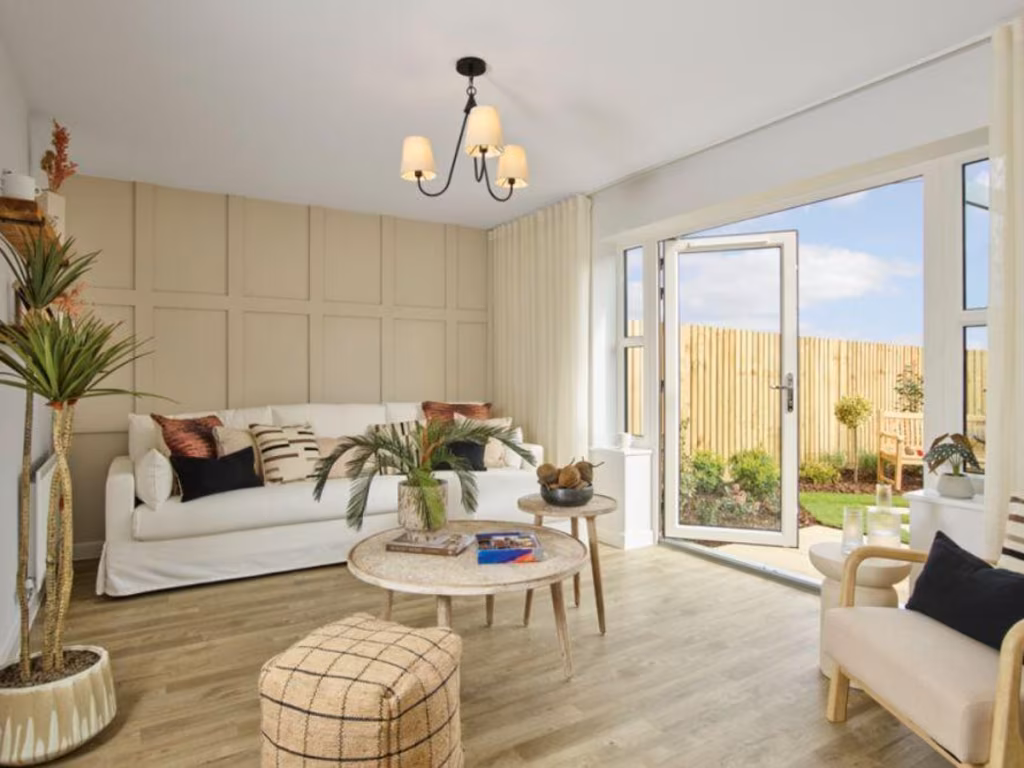
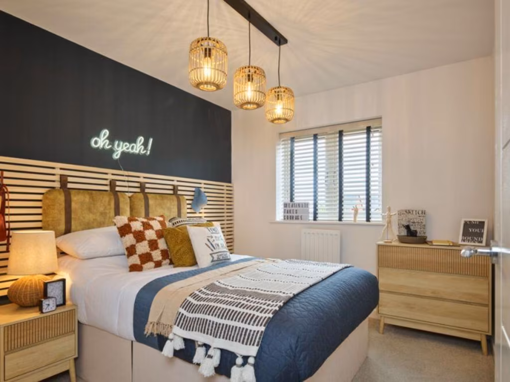
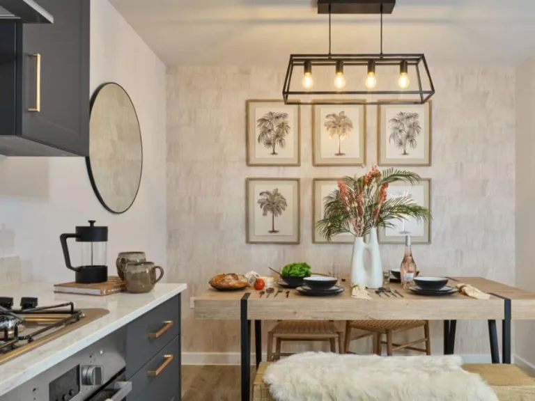
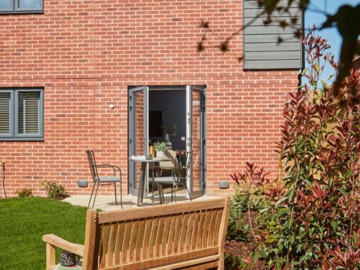
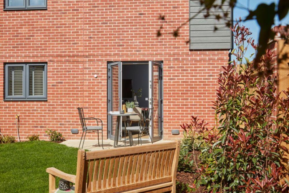
- house exterior with garden modern
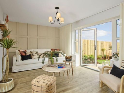
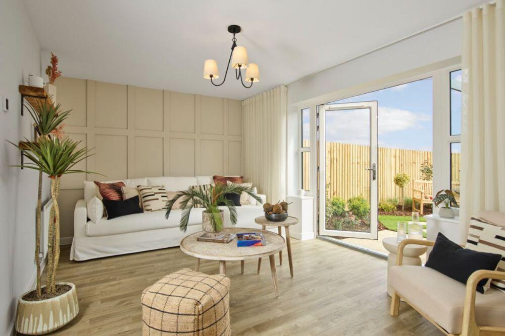
- living room modern
Floorplan Description
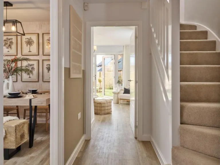
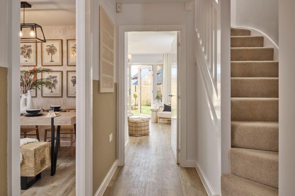
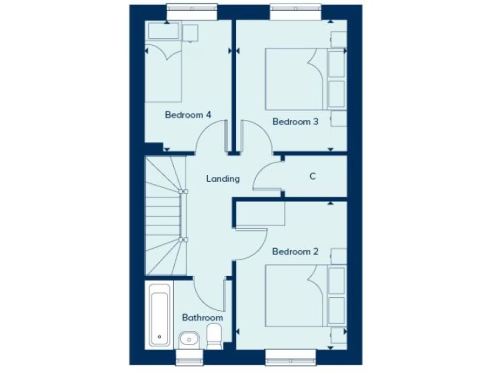
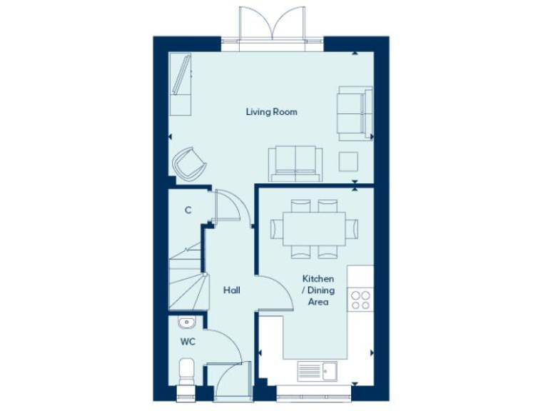
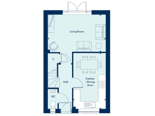
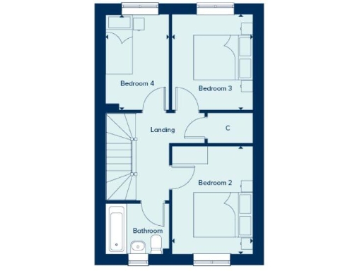
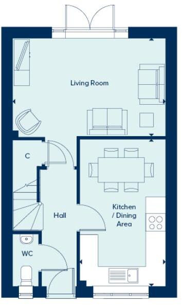
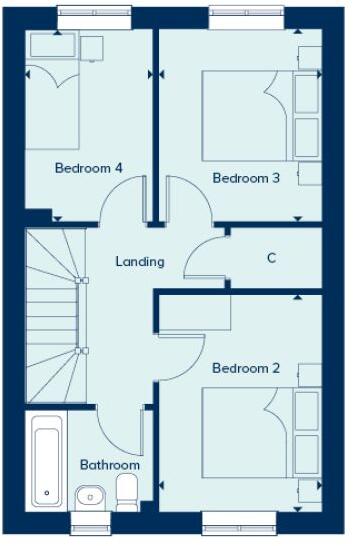
- Ground-floor plan showing living room to rear, kitchen/dining to front, hall, and WC.
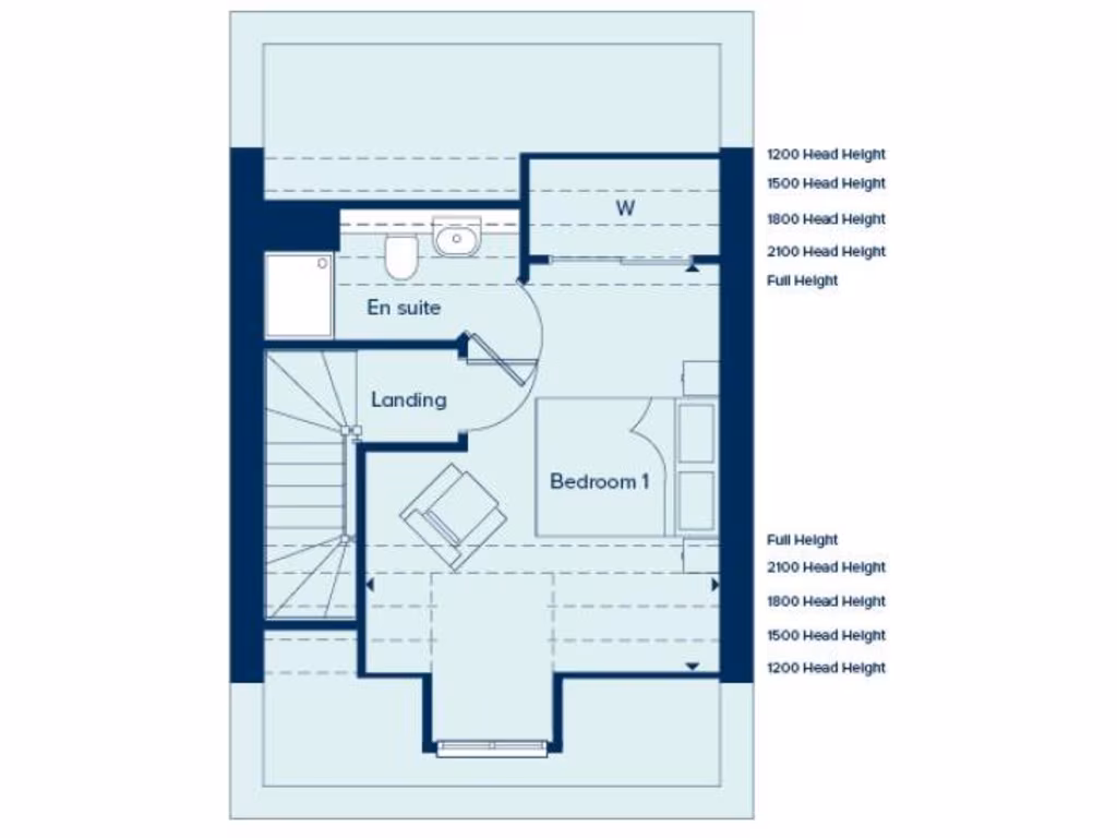
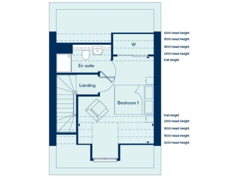
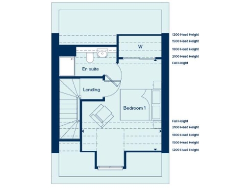
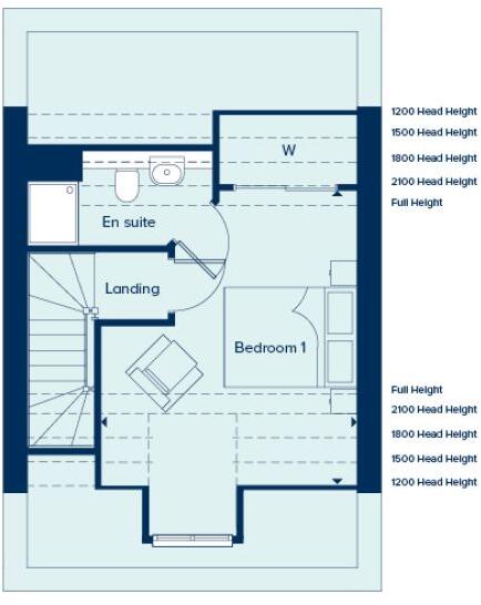
- Floorplan showing Bedroom 1, En suite, Landing and W (wardrobe).
Rooms
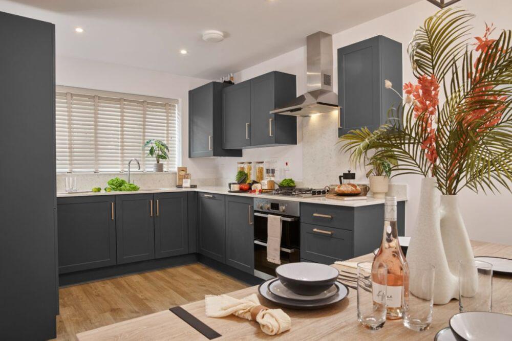
- Living Room:
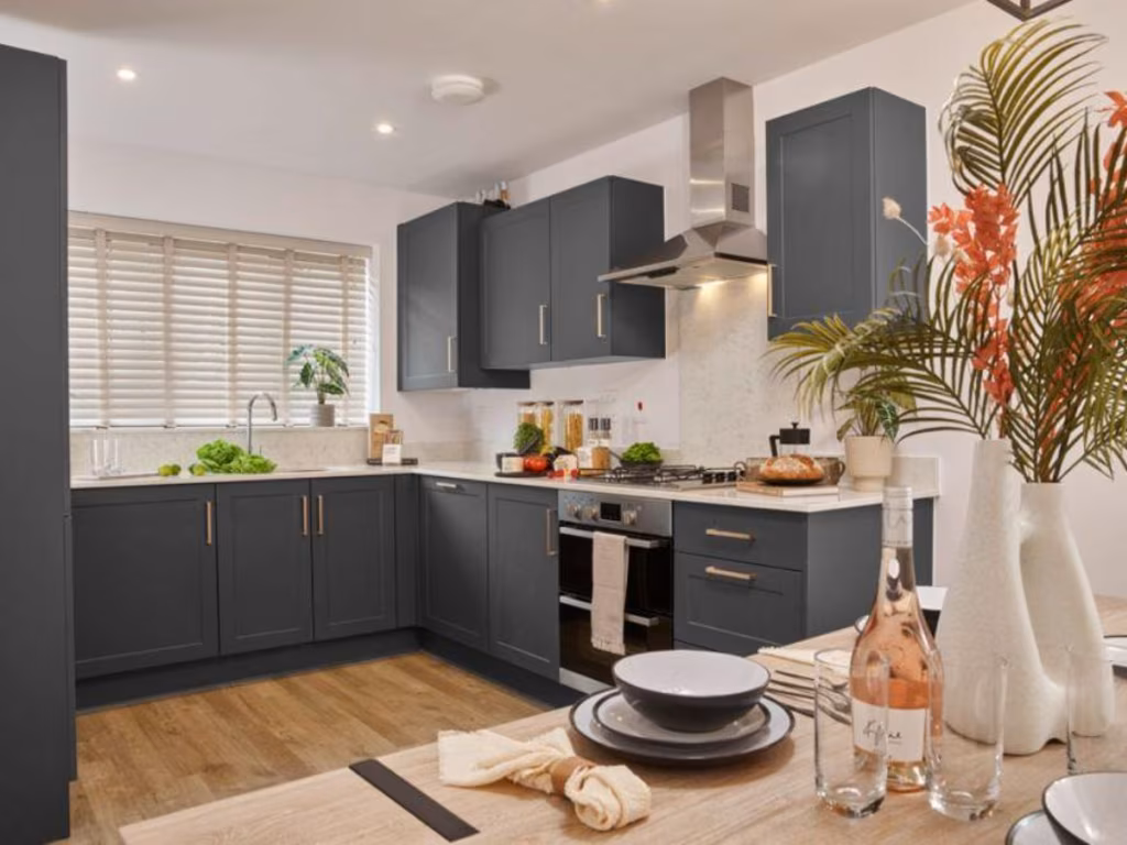
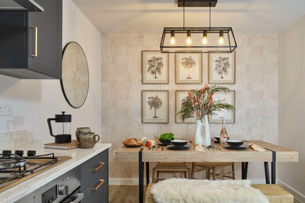
- Kitchen / Dining Area:
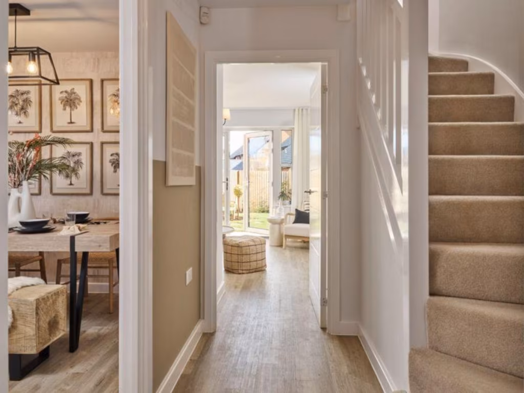
- Hall:
- WC:
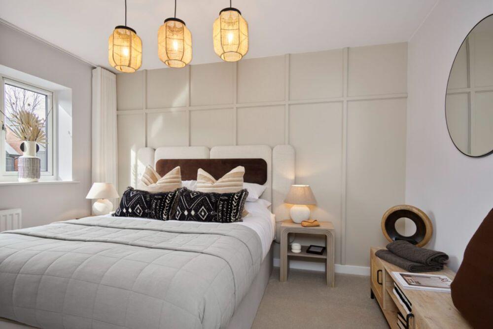
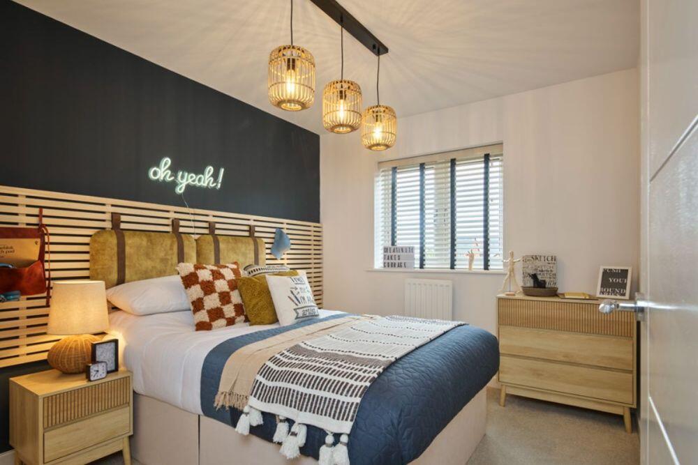
- Bedroom 4:
- Bedroom 3:
- Landing:
- C:
- Bedroom 2:
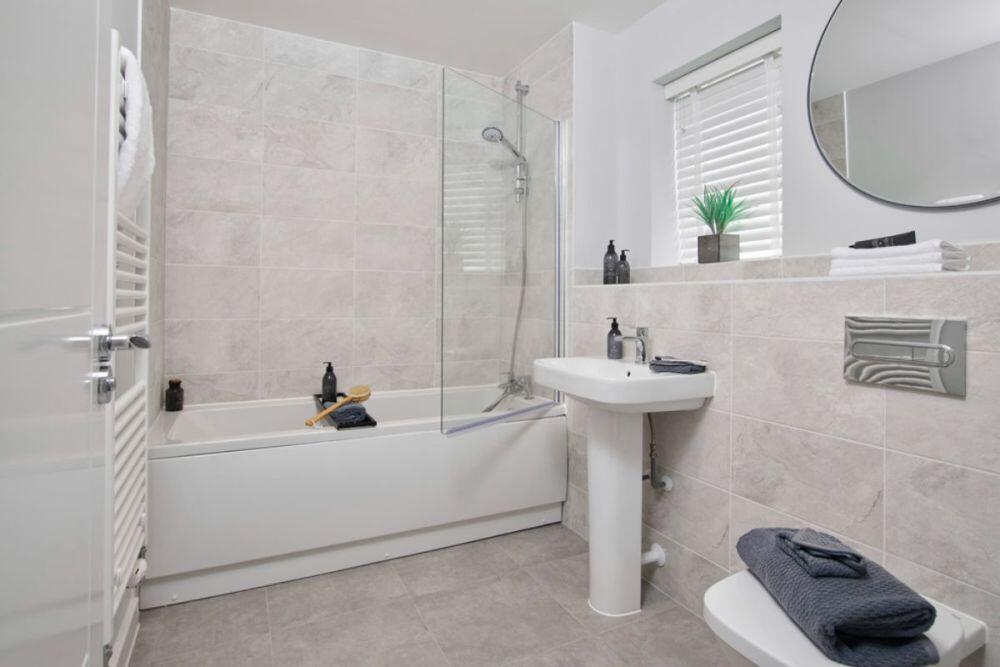
- Bathroom:
- En suite:
- Landing:
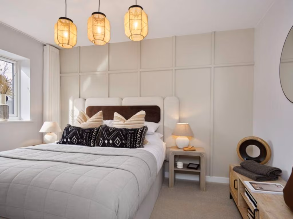
- Bedroom 1:
- W:
Textual Property Features
- Is New Build
- Has Garden
- Success
Detected Visual Features
- modern
- brick exterior
- garden
- patio
- bi-fold doors
- contemporary design
- living room
- panel walls
- wood flooring
- patio doors
- bright
- garden access
- natural light
Nearby Schools
- St Neot's School
- Gorse Ride Junior School
- Bohunt School Wokingham
- Waverley Preparatory School & Day Nursery
- Evendons Primary School
- Luckley House School
- Winnersh Primary School
- Reddam House Berkshire
- The Emmbrook School
- The Forest School
- Charles Kingsley's Church of England Primary School
- Finchampstead CofE VA Primary School
- Gorse Ride Infants' School
- Farley Hill Primary School
- Shinfield St Mary's CofE Junior School
- Shinfield Infant and Nursery School
- Walter Infant School
- St Paul's CofE Junior School
- Windmill Primary School
- The Hawthorns Primary School
- Wheatfield Primary School
- Nine Mile Ride Primary School
- The Coombes Church of England Primary School
- Bearwood Primary School
- Emmbrook Infant School
- Radstock Primary School
- Loddon Primary School
Nearest General Shops
- Id: 5915573845
- Tags:
- Name: Travis Perkins
- Shop: doityourself
- TagsNormalized:
- travis perkins
- doityourself
- shop
- Lat: 51.3809999
- Lon: -0.8836934
- FullGeoHash: gcpk7css02w7
- PartitionGeoHash: gcpk
- Images:
- FoodStandards: null
- Distance: 950.2
,- Id: 5911966472
- Tags:
- TagsNormalized:
- Lat: 51.3769791
- Lon: -0.8926593
- FullGeoHash: gcpk78vuxe0f
- PartitionGeoHash: gcpk
- Images:
- FoodStandards: null
- Distance: 939.7
,- Id: 5915816251
- Tags:
- TagsNormalized:
- Lat: 51.3770671
- Lon: -0.8928922
- FullGeoHash: gcpk78vv457q
- PartitionGeoHash: gcpk
- Images:
- FoodStandards: null
- Distance: 926.8
}
Nearest Grocery shops
- Id: 652392583
- Tags:
- Addr:
- City: Wokingham
- Housenumber: 425
- Postcode: RG40 3RL
- Street: Finchampstead Road
- Building: yes
- Name: Red Oak Stores
- Operator: Premier
- Shop: convenience
- TagsNormalized:
- Lat: 51.3772984
- Lon: -0.8561662
- FullGeoHash: gcpkk8bw3ys4
- PartitionGeoHash: gcpk
- Images:
- FoodStandards: null
- Distance: 2874.7
,- Id: 958597825
- Tags:
- Addr:
- City: Wokingham
- Housenumber: 93
- Postcode: RG40 4HB
- Street: Barkham Ride
- Brand: One Stop
- Brand:wikidata: Q65954217
- Building: yes
- Name: One Stop
- Opening_hours: Mo-Su 07:00-22:00
- Phone: +44118 973 5985
- Shop: convenience
- Website: http://onestop.co.uk
- TagsNormalized:
- Lat: 51.3821301
- Lon: -0.8583985
- FullGeoHash: gcpkk3yftg78
- PartitionGeoHash: gcpk
- Images:
- FoodStandards: null
- Distance: 2603.9
,- Id: 64381262
- Tags:
- Brand: Londis
- Brand:wikidata: Q21008564
- Brand:wikipedia: en:Londis (United Kingdom)
- Building: yes
- Name: Londis
- Shop: convenience
- Source:
- Building: OS_OpenData_StreetView
- TagsNormalized:
- Lat: 51.3955349
- Lon: -0.9060917
- FullGeoHash: gcpk7kk0ww15
- PartitionGeoHash: gcpk
- Images:
- FoodStandards: null
- Distance: 1357.9
}
Nearest Supermarkets
- Id: 46613603
- Tags:
- Addr:
- Housename: Woosehill Shopping Centre
- Postcode: RG41 3SW
- Brand: Morrisons
- Brand:wikidata: Q922344
- Brand:wikipedia: en:Morrisons
- Building: yes
- Contact:
- Website: https://my.morrisons.com/storefinder/436
- Name: Morrisons
- Operator: Morrisons
- Shop: supermarket
- Source:
- Building: OS_OpenData_StreetView
- TagsNormalized:
- Lat: 51.4143916
- Lon: -0.854045
- FullGeoHash: gcpkkxdne33b
- PartitionGeoHash: gcpk
- Images:
- FoodStandards: null
- Distance: 4338.3
,- Id: 148889156
- Tags:
- Brand: Lidl
- Brand:wikidata: Q151954
- Building: retail
- Building:levels: 1.5
- Name: Lidl Wokingham
- Shop: supermarket
- TagsNormalized:
- lidl
- retail
- supermarket
- shop
- Lat: 51.4063174
- Lon: -0.8465662
- FullGeoHash: gcpkkwpx9847
- PartitionGeoHash: gcpk
- Images:
- FoodStandards: null
- Distance: 4131.1
,- Id: 9627814519
- Tags:
- Brand: Co-op Food
- Brand:wikidata: Q3277439
- Brand:wikipedia: en:Co-op Food
- Name: Co-op Food
- Operator: The Co-operative Group
- Operator:wikidata: Q117202
- Shop: supermarket
- TagsNormalized:
- co-op
- co-op food
- food
- supermarket
- shop
- Lat: 51.3876915
- Lon: -0.9036286
- FullGeoHash: gcpk76vgpbj8
- PartitionGeoHash: gcpk
- Images:
- FoodStandards: null
- Distance: 621.4
}
Nearest Religious buildings
- Id: 312909529
- Tags:
- Name: Church Lane Copse
- Natural: wood
- Source:
- Name: OS-OpenData_StreetView
- TagsNormalized:
- Lat: 51.3775335
- Lon: -0.9171852
- FullGeoHash: gcpk70upu43j
- PartitionGeoHash: gcpk
- Images:
- FoodStandards: null
- Distance: 1725.9
,- Id: 196780863
- Tags:
- Amenity: place_of_worship
- Building: church
- Denomination: anglican
- Name: Saint James
- Religion: christian
- Wikidata: Q26411582
- TagsNormalized:
- place of worship
- church
- anglican
- christian
- Lat: 51.3915026
- Lon: -0.8745301
- FullGeoHash: gcpkk5e1jyrn
- PartitionGeoHash: gcpk
- Images:
- FoodStandards: null
- Distance: 1619.3
,- Id: 312238181
- Tags:
- Addr:
- City: Arborfield Garrison
- Housename: Tope Road
- Postcode: RG2 9NN
- Amenity: place_of_worship
- Building: yes
- Denomination: anglican
- Name: St Eligius
- Religion: christian
- Wikidata: Q105084752
- TagsNormalized:
- place of worship
- anglican
- christian
- church
- Lat: 51.3836991
- Lon: -0.8980993
- FullGeoHash: gcpk7d458zb8
- PartitionGeoHash: gcpk
- Images:
- FoodStandards: null
- Distance: 243.5
}
Nearest Medical buildings
- Id: 190556247
- Tags:
- Amenity: doctors
- Building: yes
- Healthcare: doctor
- Name: Woosehill Medical Center
- Source:
- Building: OS_OpenData_StreetView
- TagsNormalized:
- doctor
- doctors
- health
- healthcare
- Lat: 51.4137256
- Lon: -0.8551095
- FullGeoHash: gcpkkx96dt05
- PartitionGeoHash: gcpk
- Images:
- FoodStandards: null
- Distance: 4233.9
,- Id: 293937500
- Tags:
- Addr:
- City: Wokingham
- Housenumber: 422a
- Postcode: RG40 3RB
- Street: Finchampstead Road
- Amenity: pharmacy
- Dispensing: yes
- Drive_through: no
- Healthcare: pharmacy
- Name: Jats Pharmacy
- TagsNormalized:
- Lat: 51.3766938
- Lon: -0.8560009
- FullGeoHash: gcpkk8bdvtzk
- PartitionGeoHash: gcpk
- Images:
- FoodStandards: null
- Distance: 2906.9
,- Id: 6116255589
- Tags:
- Addr:
- City: Wokingham
- Housenumber: 422b
- Postcode: RG40 3RB
- Street: Finchampstead Road
- Amenity: dentist
- Contact:
- Healthcare: dentist
- Name: White Dental
- Opening_hours: Mo,Fr 08:30-17:30; Tu 07:30-17:30; We, Th 08:30-20:00; Sa "by appointment"
- Website: https://whitedentalfinchampstead.co.uk/
- TagsNormalized:
- dentist
- health
- healthcare
- dental
- Lat: 51.3766248
- Lon: -0.8560858
- FullGeoHash: gcpkk8bdec00
- PartitionGeoHash: gcpk
- Images:
- FoodStandards: null
- Distance: 2903.8
,- Id: 958604786
- Tags:
- Amenity: doctors
- Building: yes
- Healthcare: doctor
- Name: The Finchampstead Surgery
- TagsNormalized:
- doctor
- doctors
- health
- healthcare
- surgery
- Lat: 51.3750768
- Lon: -0.8579868
- FullGeoHash: gcpkk2x1x2qw
- PartitionGeoHash: gcpk
- Images:
- FoodStandards: null
- Distance: 2843.5
}
Nearest Airports
- Id: 14001268
- Tags:
- Access: yes
- Aerodrome: international
- Aerodrome:type: public
- Aeroway: aerodrome
- Alt_name: London Heathrow
- Alt_name_2: London Heathrow Airport
- Ele: 25
- Iata: LHR
- Icao: EGLL
- Int_name: Heathrow Airport
- Name: London Heathrow Airport
- Note: area still approx
- Old_name: London Airport
- Operator: Heathrow Airport Limited
- Rank_aci:
- Ref: LHR
- Short_name: Heathrow
- Type: multipolygon
- Website: https://www.heathrow.com/
- Wikidata: Q8691
- Wikipedia: en:Heathrow Airport
- TagsNormalized:
- airport
- international airport
- Lat: 51.4677522
- Lon: -0.4547736
- FullGeoHash: gcpsv9kv7h2h
- PartitionGeoHash: gcps
- Images:
- FoodStandards: null
- Distance: 31910.4
}
Nearest Leisure Facilities
- Id: 310984369
- Tags:
- TagsNormalized:
- Lat: 51.3841591
- Lon: -0.9005699
- FullGeoHash: gcpk7d0nrjw2
- PartitionGeoHash: gcpk
- Images:
- FoodStandards: null
- Distance: 365.5
,- Id: 285591271
- Tags:
- TagsNormalized:
- Lat: 51.3829329
- Lon: -0.8987627
- FullGeoHash: gcpk79cx32cv
- PartitionGeoHash: gcpk
- Images:
- FoodStandards: null
- Distance: 337.2
,- Id: 285587745
- Tags:
- Leisure: pitch
- Lit: no
- Pitch:
- Source: Bing
- Sport: tennis
- Surface: asphalt
- TagsNormalized:
- Lat: 51.3842575
- Lon: -0.8992023
- FullGeoHash: gcpk7d1nzpf5
- PartitionGeoHash: gcpk
- Images:
- FoodStandards: null
- Distance: 273
,- Id: 310984368
- Tags:
- TagsNormalized:
- Lat: 51.3855391
- Lon: -0.8993175
- FullGeoHash: gcpk7d3nkqu2
- PartitionGeoHash: gcpk
- Images:
- FoodStandards: null
- Distance: 260.9
,- Id: 310372445
- Tags:
- Leisure: pitch
- Sport: cricket
- Surface: grass
- TagsNormalized:
- pitch
- leisure
- cricket
- sports
- Lat: 51.3842789
- Lon: -0.8968354
- FullGeoHash: gcpk7d4zn5z5
- PartitionGeoHash: gcpk
- Images:
- FoodStandards: null
- Distance: 136.6
}
Nearest Tourist attractions
- Id: 1854241639
- Tags:
- Name: California Country Park
- Tourism: attraction
- Wikidata: Q5020366
- Wikipedia: en:California Country Park
- TagsNormalized:
- Lat: 51.3791101
- Lon: -0.8743286
- FullGeoHash: gcpkk17348m3
- PartitionGeoHash: gcpk
- Images:
- FoodStandards: null
- Distance: 1624.9
,- Id: 5642670339
- Tags:
- Amenity: telephone
- Booth: K6
- Covered: booth
- Man_made: telephone_box
- Mapillary: 496069058664405
- Survey:
- Tourism: information
- TagsNormalized:
- Lat: 51.3974406
- Lon: -0.9067166
- FullGeoHash: gcpk7keezcr5
- PartitionGeoHash: gcpk
- Images:
- FoodStandards: null
- Distance: 1561.9
,- Id: 682405922
- Tags:
- Name: Bluebell Farm (Caravan Club CL Site
- Tourism: caravan_site
- TagsNormalized:
- Lat: 51.3837309
- Lon: -0.8829885
- FullGeoHash: gcpk7fj5bvsn
- PartitionGeoHash: gcpk
- Images:
- FoodStandards: null
- Distance: 890.2
}
Nearest Train stations
- Id: 1622191508
- Tags:
- Name: Sandhurst
- Naptan:
- Network: National Rail
- Operator: Great Western Railway
- Public_transport: station
- Railway: station
- Ref:
- Source: bing
- Source:operator: Local Knowledge
- Wheelchair: no
- Wikidata: Q2848846
- Wikipedia: en:Sandhurst railway station
- TagsNormalized:
- Lat: 51.3465435
- Lon: -0.8038071
- FullGeoHash: gcpkjeqemcmy
- PartitionGeoHash: gcpk
- Images:
- FoodStandards: null
- Distance: 7688.1
,- Id: 1622191469
- Tags:
- Name: Crowthorne
- Naptan:
- Network: National Rail
- Public_transport: station
- Railway: station
- Ref:
- Source: bing
- Wheelchair: yes
- Wikidata: Q4371483
- Wikipedia: en:Crowthorne railway station
- TagsNormalized:
- Lat: 51.3664877
- Lon: -0.8192585
- FullGeoHash: gcpkjqgrmzkd
- PartitionGeoHash: gcpk
- Images:
- FoodStandards: null
- Distance: 5693.2
,- Id: 6022636082
- Tags:
- Name: Winnersh
- Naptan:
- Network: National Rail
- Public_transport: station
- Railway: station
- Ref:
- Wikidata: Q3543567
- Wikipedia: en:Winnersh railway station
- TagsNormalized:
- Lat: 51.4307527
- Lon: -0.8779199
- FullGeoHash: gcpks48tygpq
- PartitionGeoHash: gcpk
- Images:
- FoodStandards: null
- Distance: 5208.2
,- Id: 7756847448
- Tags:
- Public_transport: station
- Railway: station
- Train: yes
- Usage: tourism
- TagsNormalized:
- Lat: 51.3584485
- Lon: -0.9518419
- FullGeoHash: gcpk4mdbskxn
- PartitionGeoHash: gcpk
- Images:
- FoodStandards: null
- Distance: 4910.7
,- Id: 15721189
- Tags:
- Name: Wokingham
- Naptan:
- Network: National Rail
- Operator: South West Trains
- Public_transport: station
- Railway: station
- Ref:
- Wheelchair: yes
- Wikidata: Q2588372
- Wikipedia: en:Wokingham railway station
- TagsNormalized:
- Lat: 51.4119036
- Lon: -0.8429813
- FullGeoHash: gcpkkz60j17w
- PartitionGeoHash: gcpk
- Images:
- FoodStandards: null
- Distance: 4702.9
}
Nearest Bus stations and stops
- Id: 3018308086
- Tags:
- Bench: yes
- Highway: bus_stop
- Name: Sheerlands Road
- Operator: Reading Buses
- Public_transport: platform
- Shelter: yes
- TagsNormalized:
- Lat: 51.3838047
- Lon: -0.8998242
- FullGeoHash: gcpk7d0u2e6q
- PartitionGeoHash: gcpk
- Images:
- FoodStandards: null
- Distance: 333.9
,- Id: 9644344942
- Tags:
- Bus: yes
- Highway: bus_stop
- Public_transport: platform
- Shelter: no
- TagsNormalized:
- Lat: 51.382801
- Lon: -0.8983897
- FullGeoHash: gcpk79cyd025
- PartitionGeoHash: gcpk
- Images:
- FoodStandards: null
- Distance: 332.7
,- Id: 10181437466
- Tags:
- Bus: yes
- Highway: bus_stop
- Public_transport: platform
- TagsNormalized:
- Lat: 51.3871744
- Lon: -0.8929618
- FullGeoHash: gcpk7dtzbrx7
- PartitionGeoHash: gcpk
- Images:
- FoodStandards: null
- Distance: 282.9
,- Id: 9644344945
- Tags:
- Bus: yes
- Highway: bus_stop
- Public_transport: platform
- Shelter: no
- TagsNormalized:
- Lat: 51.3834039
- Lon: -0.8984261
- FullGeoHash: gcpk7d1f10sz
- PartitionGeoHash: gcpk
- Images:
- FoodStandards: null
- Distance: 282.8
,- Id: 10181437467
- Tags:
- Bus: yes
- Highway: bus_stop
- Public_transport: platform
- TagsNormalized:
- Lat: 51.3871245
- Lon: -0.8933603
- FullGeoHash: gcpk7dtrxnq3
- PartitionGeoHash: gcpk
- Images:
- FoodStandards: null
- Distance: 261.4
}
Nearest Hotels
- Id: 134577562
- Tags:
- Addr:
- Postcode: RG40 2AN
- Street: Wellington Road
- Building: yes
- Contact:
- Name: Cantley Lodge
- Tourism: hotel
- TagsNormalized:
- Lat: 51.4097887
- Lon: -0.8415161
- FullGeoHash: gcpkkyg5xr0n
- PartitionGeoHash: gcpk
- Images:
- FoodStandards: null
- Distance: 4640.1
,- Id: 197889337
- Tags:
- Landuse: commercial
- Name: Shinfield Grange (Conference Centre)
- Tourism: hotel
- TagsNormalized:
- conference centre
- hotel
- tourism
- Lat: 51.4137664
- Lon: -0.9358765
- FullGeoHash: gcpk6xwdbkxy
- PartitionGeoHash: gcpk
- Images:
- FoodStandards: null
- Distance: 4228.4
,- Id: 2872175
- Tags:
- Addr:
- City: Eversley
- Street: The Street
- Building: yes
- Name: Warbrook House Hotel
- Source:
- Building: OS_OpenData_StreetView
- Tourism: hotel
- Type: multipolygon
- Website: https://www.warbrookhouse.com/
- TagsNormalized:
- Lat: 51.350031
- Lon: -0.8899876
- FullGeoHash: gcpk5ezztg94
- PartitionGeoHash: gcpk
- Images:
- FoodStandards: null
- Distance: 3933.2
}
Tags
- modern
- brick exterior
- garden
- patio
- bi-fold doors
- contemporary design
- modern
- living room
- panel walls
- wood flooring
- patio doors
- bright
- garden access
- natural light
Local Market Stats
- Average Price/sqft: £407
- Avg Income: £58000
- Rental Yield: 5%
- Social Housing: 10%
- Planning Success Rate: 90%
AirBnB Data
- 1km average: £86/night
- Listings in 1km: 1
Similar Properties
 4 bedroom semi-detached house for sale in Arborfield,
Berkshire,
RG2 9LN, RG2 — £565,000 • 4 bed • 1 bath • 773 ft²
4 bedroom semi-detached house for sale in Arborfield,
Berkshire,
RG2 9LN, RG2 — £565,000 • 4 bed • 1 bath • 773 ft²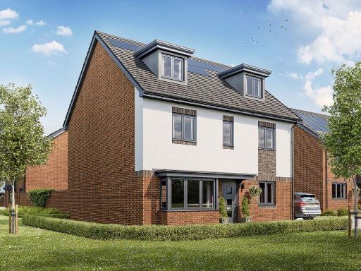 5 bedroom detached house for sale in Arborfield,
Berkshire,
RG2 9LN, RG2 — £815,000 • 5 bed • 1 bath • 1229 ft²
5 bedroom detached house for sale in Arborfield,
Berkshire,
RG2 9LN, RG2 — £815,000 • 5 bed • 1 bath • 1229 ft²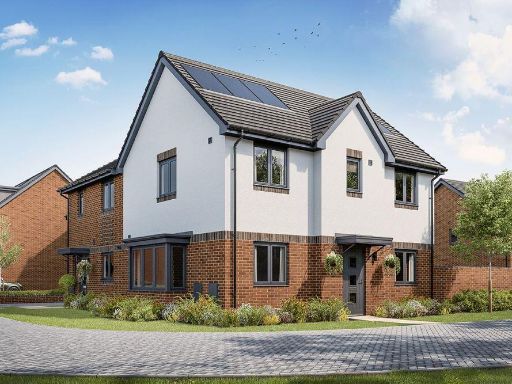 3 bedroom semi-detached house for sale in Arborfield,
Berkshire,
RG2 9LN, RG2 — £565,000 • 3 bed • 1 bath • 655 ft²
3 bedroom semi-detached house for sale in Arborfield,
Berkshire,
RG2 9LN, RG2 — £565,000 • 3 bed • 1 bath • 655 ft² 3 bedroom end of terrace house for sale in Arborfield,
Berkshire,
RG2 9LN, RG2 — £495,000 • 3 bed • 1 bath • 637 ft²
3 bedroom end of terrace house for sale in Arborfield,
Berkshire,
RG2 9LN, RG2 — £495,000 • 3 bed • 1 bath • 637 ft²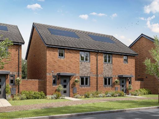 3 bedroom end of terrace house for sale in Arborfield,
Berkshire,
RG2 9LN, RG2 — £505,000 • 3 bed • 1 bath • 637 ft²
3 bedroom end of terrace house for sale in Arborfield,
Berkshire,
RG2 9LN, RG2 — £505,000 • 3 bed • 1 bath • 637 ft²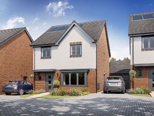 4 bedroom detached house for sale in Arborfield,
Berkshire,
RG2 9LN, RG2 — £630,000 • 4 bed • 1 bath • 854 ft²
4 bedroom detached house for sale in Arborfield,
Berkshire,
RG2 9LN, RG2 — £630,000 • 4 bed • 1 bath • 854 ft²
Meta
- {
"@context": "https://schema.org",
"@type": "Residence",
"name": "4 bedroom end of terrace house for sale in Arborfield, Berk…",
"description": "",
"url": "https://propertypiper.co.uk/property/79f913aa-37f7-42f8-ac36-5e74cedb9524",
"image": "https://image-a.propertypiper.co.uk/29f157e7-72d7-4b8c-96d4-39902239190e-1024.jpeg",
"address": {
"@type": "PostalAddress",
"streetAddress": "Arborfield,\r\nBerkshire,\r\nRG2 9LN",
"postalCode": "RG2 9LN",
"addressLocality": "Wokingham",
"addressRegion": "Wokingham",
"addressCountry": "England"
},
"geo": {
"@type": "GeoCoordinates",
"latitude": 51.38523,
"longitude": -0.89559
},
"numberOfRooms": 4,
"numberOfBathroomsTotal": 1,
"floorSize": {
"@type": "QuantitativeValue",
"value": 773,
"unitCode": "FTK"
},
"offers": {
"@type": "Offer",
"price": 550000,
"priceCurrency": "GBP",
"availability": "https://schema.org/InStock"
},
"additionalProperty": [
{
"@type": "PropertyValue",
"name": "Feature",
"value": "modern"
},
{
"@type": "PropertyValue",
"name": "Feature",
"value": "brick exterior"
},
{
"@type": "PropertyValue",
"name": "Feature",
"value": "garden"
},
{
"@type": "PropertyValue",
"name": "Feature",
"value": "patio"
},
{
"@type": "PropertyValue",
"name": "Feature",
"value": "bi-fold doors"
},
{
"@type": "PropertyValue",
"name": "Feature",
"value": "contemporary design"
},
{
"@type": "PropertyValue",
"name": "Feature",
"value": "modern"
},
{
"@type": "PropertyValue",
"name": "Feature",
"value": "living room"
},
{
"@type": "PropertyValue",
"name": "Feature",
"value": "panel walls"
},
{
"@type": "PropertyValue",
"name": "Feature",
"value": "wood flooring"
},
{
"@type": "PropertyValue",
"name": "Feature",
"value": "patio doors"
},
{
"@type": "PropertyValue",
"name": "Feature",
"value": "bright"
},
{
"@type": "PropertyValue",
"name": "Feature",
"value": "garden access"
},
{
"@type": "PropertyValue",
"name": "Feature",
"value": "natural light"
}
]
}
High Res Floorplan Images
Compatible Floorplan Images
FloorplanImages Thumbnail