TN30 7BF - End of terrace house for sale in Bishop Crescent, Tenterden…
View on Property Piper
End of terrace house for sale in Bishop Crescent, Tenterden, Kent, TN30
Property Details
- Price: £112000
- Bedrooms: 1
- Bathrooms: 1
- Property Type: undefined
- Property SubType: undefined
Image Descriptions
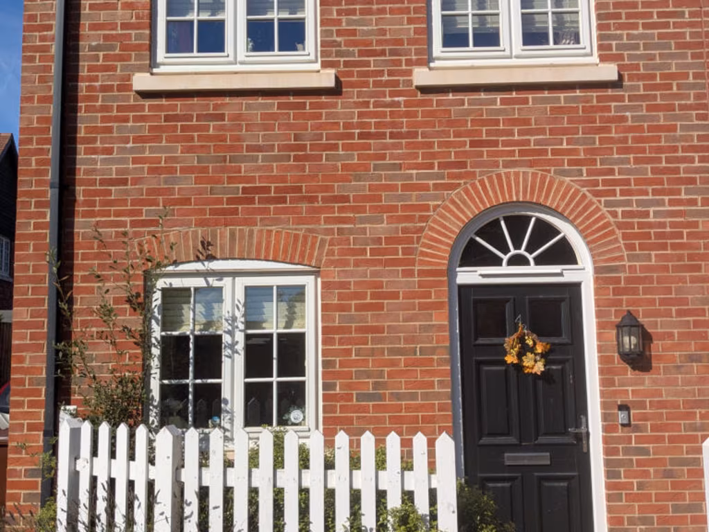
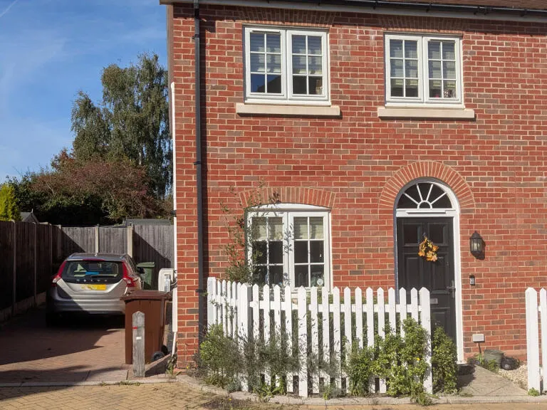
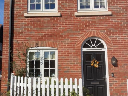
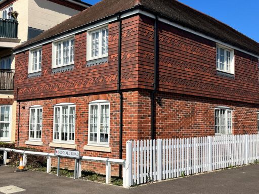
- a red-brick detached house Modern Traditional
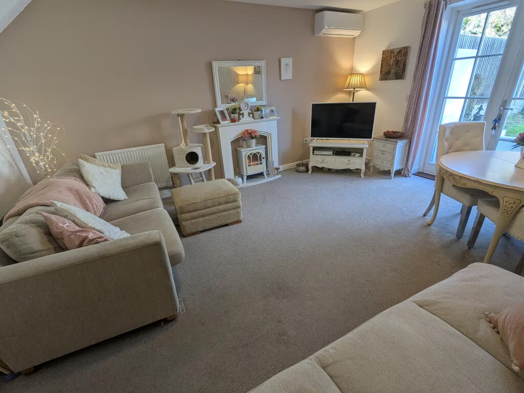
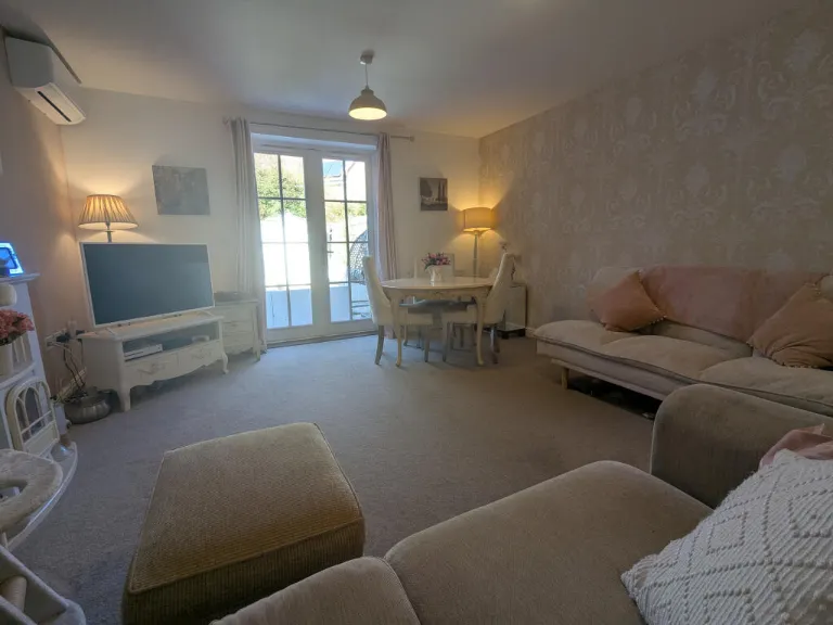
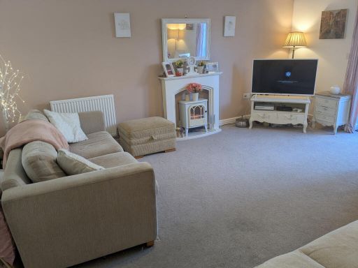
- living room modern
Textual Property Features
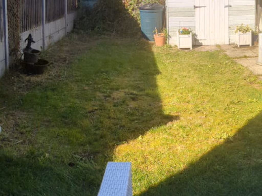
- Is Shared Ownership
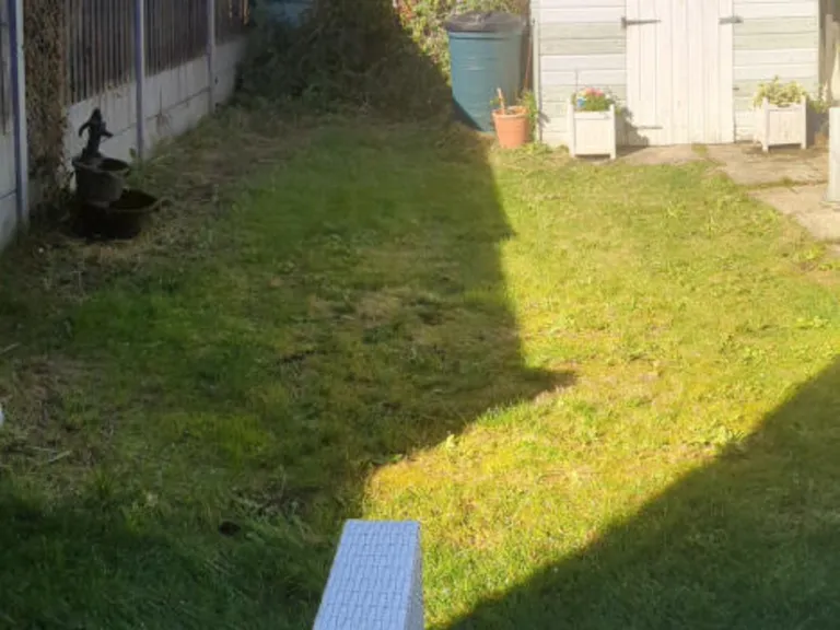
- Has Garden
- Success
Detected Visual Features
- red brick
- detached
- modern traditional
- two-story
- gable roof
- white fence
- driveway
- front garden
- suburban
- modern living room
- standard ceiling
- electric fireplace
- beige walls
- neutral tones
- radiator heating
- corner placement
- carpet flooring
EPC Details
- High performance glazing
- Average thermal transmittance 0.25 W/m-¦K
- Boiler and radiators, mains gas
- Low energy lighting in all fixed outlets
- Average thermal transmittance 0.15 W/m-¦K
Nearby Schools
- Benenden Church of England Primary School
- Homewood School and Sixth Form Centre
- St Michael's Church of England Primary School
- Rolvenden Primary School
- Tenterden Church of England Junior School
- Woodchurch Church of England Primary School
- Wittersham Church of England Primary School
- High Halden Church of England Primary School
- Bethersden Primary School
- Tenterden Infant School
- John Mayne Church of England Primary School
Nearest Bars And Restaurants
- Id: 488105610
- Tags:
- Addr:
- City: Tenterden
- Housename: 13-15
- Postcode: TN30 6BN
- Street: High Street
- Amenity: cafe
- Brand: Costa
- Brand:wikidata: Q608845
- Brand:wikipedia: en:Costa Coffee
- Building: yes
- Cuisine: coffee_shop
- Internet_access: wlan
- Name: Costa
- Takeaway: yes
- TagsNormalized:
- Lat: 51.0685578
- Lon: 0.6887389
- FullGeoHash: u106x8txbv0v
- PartitionGeoHash: u106
- Images:
- FoodStandards: null
- Distance: 378.5
,- Id: 9945024438
- Tags:
- TagsNormalized:
- Lat: 51.068361
- Lon: 0.6880523
- FullGeoHash: u106x8tnbb2z
- PartitionGeoHash: u106
- Images:
- FoodStandards: null
- Distance: 347.2
,- Id: 4960530741
- Tags:
- Addr:
- Housenumber: 52
- Postcode: TN30 6AU
- Street: High Street
- Amenity: restaurant
- Brand: Prezzo
- Brand:wikidata: Q7242489
- Brand:wikipedia: en:Prezzo (restaurant)
- Cuisine: italian
- Name: Prezzo
- Phone: +44 1580 764769
- Source:
- Wheelchair: no
- TagsNormalized:
- Lat: 51.0682351
- Lon: 0.6866259
- FullGeoHash: u106x8eyp912
- PartitionGeoHash: u106
- Images:
- FoodStandards: null
- Distance: 333.1
,- Id: 737618856
- Tags:
- Addr:
- Housename: Manor Row
- Street: High Street
- Unit: 4
- Amenity: restaurant
- Cuisine: regional
- Name: Zest
- TagsNormalized:
- Lat: 51.0675188
- Lon: 0.6841761
- FullGeoHash: u106x8d1y7qx
- PartitionGeoHash: u106
- Images:
- FoodStandards: null
- Distance: 332.9
,- Id: 8292973257
- Tags:
- Addr:
- Housenumber: 43
- Street: High Street
- Amenity: restaurant
- Brand: Café Rouge
- Brand:wikidata: Q5017261
- Brand:wikipedia: en:Café Rouge
- Cuisine: french
- Name: Café Rouge
- TagsNormalized:
- Lat: 51.0682043
- Lon: 0.687477
- FullGeoHash: u106x8stg7k0
- PartitionGeoHash: u106
- Images:
- FoodStandards: null
- Distance: 326.2
}
Nearest General Shops
- Id: 487835990
- Tags:
- Addr:
- Housenumber: 47
- Street: High Street
- Brand: Waterstones
- Brand:wikidata: Q151779
- Brand:wikipedia: en:Waterstones
- Building: yes
- Name: Waterstones
- Shop: books
- Wikidata: Q26324195
- TagsNormalized:
- Lat: 51.0680731
- Lon: 0.6872459
- FullGeoHash: u106x8smjfz9
- PartitionGeoHash: u106
- Images:
- FoodStandards: null
- Distance: 311.5
,- Id: 9945024445
- Tags:
- Name: Pilgrims Hospices
- Shop: charity
- TagsNormalized:
- Lat: 51.0680585
- Lon: 0.6871203
- FullGeoHash: u106x8sm5044
- PartitionGeoHash: u106
- Images:
- FoodStandards: null
- Distance: 310.2
,- Id: 9945024446
- Tags:
- Brand: White Stuff
- Brand:wikidata: Q7995442
- Name: White Stuff
- Shop: clothes
- TagsNormalized:
- Lat: 51.0679329
- Lon: 0.6868534
- FullGeoHash: u106x8shkbej
- PartitionGeoHash: u106
- Images:
- FoodStandards: null
- Distance: 297.7
}
Nearest Grocery shops
- Id: 871994443
- Tags:
- Brand: Costcutter
- Brand:wikidata: Q5175072
- Brand:wikipedia: en:Costcutter
- Name: Costcutter
- Shop: convenience
- TagsNormalized:
- costcutter
- convenience
- shop
- Lat: 51.052737
- Lon: 0.6296732
- FullGeoHash: u106qmfe8ryq
- PartitionGeoHash: u106
- Images:
- FoodStandards: null
- Distance: 4263.4
,- Id: 886306602
- Tags:
- Brand: Tiger Mart
- Brand:wikidata: Q57643977
- Building: yes
- Name: Tiger Mart
- Shop: convenience
- Source: Bing
- TagsNormalized:
- Lat: 51.0658561
- Lon: 0.6658707
- FullGeoHash: u106x0kb5vt1
- PartitionGeoHash: u106
- Images:
- FoodStandards: null
- Distance: 1500.6
,- Id: 5110967828
- Tags:
- Brand: Holland & Barrett
- Brand:wikidata: Q5880870
- Brand:wikipedia: en:Holland & Barrett
- Name: Holland & Barrett
- Shop: health_food
- TagsNormalized:
- holland & barrett
- health
- health food
- food
- shop
- Lat: 51.0689541
- Lon: 0.6885482
- FullGeoHash: u106x8v6hr4c
- PartitionGeoHash: u106
- Images:
- FoodStandards: null
- Distance: 418.3
}
Nearest Supermarkets
- Id: 456411153
- Tags:
- Addr:
- City: Cranbrook
- County: Kent
- Postcode: TN18 4HG
- Street: Rye Road
- Village: Hawkhurst
- Brand: Tesco
- Brand:wikidata: Q487494
- Building: yes
- Fhrs:
- Name: Tesco
- Opening_hours: Mo-Sa 08:00-22:00 Su 10:00-16:00
- Operator: Tesco
- Shop: supermarket
- Source:
- TagsNormalized:
- Lat: 51.0476747
- Lon: 0.5147404
- FullGeoHash: u1067syy6262
- PartitionGeoHash: u106
- Images:
- FoodStandards:
- Id: 510915
- FHRSID: 510915
- LocalAuthorityBusinessID: 13/00014/MIXED
- BusinessName: Tesco
- BusinessType: Retailers - supermarkets/hypermarkets
- BusinessTypeID: 7840
- AddressLine1: Rye Road
- AddressLine2: Hawkhurst
- AddressLine3: Cranbrook
- AddressLine4: Kent
- PostCode: TN18 4HG
- RatingValue: 5
- RatingKey: fhrs_5_en-GB
- RatingDate: 2022-05-03
- LocalAuthorityCode: 192
- LocalAuthorityName: Tunbridge Wells
- LocalAuthorityWebSite: http://www.tunbridgewells.gov.uk
- LocalAuthorityEmailAddress: EHAdmin@Midkent.gov.uk
- Scores:
- Hygiene: 0
- Structural: 0
- ConfidenceInManagement: 0
- NewRatingPending: false
- Geocode:
- Longitude: 0.51401300000000
- Latitude: 51.04769900000000
- Distance: 12219.9
,- Id: 199625562
- Tags:
- Addr:
- Housenumber: 10
- Postcode: TN30 6BW
- Street: Sayers Lane
- Alt_name: Waitrose Tenterden
- Brand: Waitrose
- Brand:wikidata: Q771734
- Brand:wikipedia: en:Waitrose
- Building: yes
- Name: Waitrose
- Official_name: Waitrose & Partners
- Operator: Waitrose & Partners
- Shop: supermarket
- Source: survey
- TagsNormalized:
- Lat: 51.0680209
- Lon: 0.6887594
- FullGeoHash: u106x8tsc304
- PartitionGeoHash: u106
- Images:
- FoodStandards: null
- Distance: 321.7
,- Id: 199625561
- Tags:
- Addr:
- Housename: Highbury Works
- Postcode: TN30 7LN
- Street: Tenterden Road
- Alt_name: Tesco Tenderden Superstore
- Brand: Tesco
- Brand:wikidata: Q487494
- Brand:wikipedia: en:Tesco
- Building: yes
- Contact:
- Website: https://www.tesco.com/store-locator/tenterden/highbury-works
- Name: Tesco
- Shop: supermarket
- TagsNormalized:
- Lat: 51.0658909
- Lon: 0.6856035
- FullGeoHash: u106x870rsp0
- PartitionGeoHash: u106
- Images:
- FoodStandards: null
- Distance: 138.6
}
Nearest Religious buildings
- Id: 58680499
- Tags:
- Amenity: place_of_worship
- Building: yes
- Denomination: anglican
- Heritage: yes
- Name: St Mildreds C of E church
- Religion: christian
- Wikidata: Q17529438
- TagsNormalized:
- place of worship
- anglican
- church
- christian
- Lat: 51.0687475
- Lon: 0.6871729
- FullGeoHash: u106x8u3h292
- PartitionGeoHash: u106
- Images:
- FoodStandards: null
- Distance: 386.6
,- Id: 403519858
- Tags:
- Addr:
- City: Tenterden
- Country: GB
- Postcode: TN30 6RA
- Street: Recreation Ground Road
- Amenity: school
- Capacity: 240
- Contact:
- Phone: +44 1580 763717
- Website: https://www.tenterdenprimaryfederation.kent.sch.uk/
- Denomination: anglican
- Diocese: Diocese of Canterbury
- Isced:
- Max_age: 11
- Min_age: 7
- Name: Tenterden Church of England Junior School
- Ref:
- Ref:edubase:group: 16502
- Religion: christian
- School:
- Boarding: no
- Gender: mixed
- Selective: no
- Trust: yes
- Type: academy
- School:trust:name: Tenterden Schools Trust
- School:trust:type: multi_academy
- Wikidata: Q66231728
- TagsNormalized:
- school
- anglican
- church
- christian
- Lat: 51.0671123
- Lon: 0.6900116
- FullGeoHash: u106x8qrqrty
- PartitionGeoHash: u106
- Images:
- FoodStandards: null
- Distance: 277.7
,- Id: 1119285225
- Tags:
- Amenity: place_of_worship
- Denomination: baptist
- Name: Zion Baptist Church Tenterden
- Religion: christian
- Source: OS_OpenData_StreetView
- TagsNormalized:
- place of worship
- baptist
- church
- christian
- Lat: 51.0675819
- Lon: 0.6859891
- FullGeoHash: u106x8ed0xnx
- PartitionGeoHash: u106
- Images:
- FoodStandards: null
- Distance: 273.3
}
Nearest Medical buildings
- Id: 165813912
- Tags:
- Amenity: hospital
- Healthcare: hospital
- Name: West View Hospital
- Note: Care home
- TagsNormalized:
- Lat: 51.0641373
- Lon: 0.6749555
- FullGeoHash: u106rrgqpt5k
- PartitionGeoHash: u106
- Images:
- FoodStandards: null
- Distance: 873.5
,- Id: 7079391617
- Tags:
- Amenity: pharmacy
- Brand: Boots
- Brand:wikidata: Q6123139
- Brand:wikipedia: en:Boots (company)
- Healthcare: pharmacy
- Name: Boots
- Website: https://www.boots.com/stores/982-tenterden-high-street-tn30-6ah
- Wheelchair: yes
- TagsNormalized:
- pharmacy
- boots
- health
- healthcare
- Lat: 51.0692964
- Lon: 0.6894095
- FullGeoHash: u106x8yh0qug
- PartitionGeoHash: u106
- Images:
- FoodStandards: null
- Distance: 470.6
,- Id: 4090180429
- Tags:
- Addr:
- City: Tenterden
- Housenumber: 4
- Postcode: TN30 6BN
- Street: High Street
- Amenity: dentist
- Description: Dental clinic providing Private Dental Healthcare
- Healthcare: dentist
- Name: EasySmile Dental Practice
- Phone: +44 1580763686
- Website: https://myeasysmile.co.uk/
- TagsNormalized:
- dentist
- health
- healthcare
- dental
- Lat: 51.0687403
- Lon: 0.6893067
- FullGeoHash: u106x8vbyp0m
- PartitionGeoHash: u106
- Images:
- FoodStandards: null
- Distance: 409.8
,- Id: 2269449268
- Tags:
- Addr:
- City: Tenterden
- Postcode: TN30 6RB
- Street: Recreation Ground Road
- Amenity: hospital
- Emergency: no
- Healthcare: hospital
- Name: Ivy Court Surgery (temporary location)
- TagsNormalized:
- hospital
- health
- healthcare
- surgery
- Lat: 51.0678935
- Lon: 0.6909309
- FullGeoHash: u106x8xh5c76
- PartitionGeoHash: u106
- Images:
- FoodStandards: null
- Distance: 385.3
}
Nearest Leisure Facilities
- Id: 27097493
- Tags:
- TagsNormalized:
- Lat: 51.0676038
- Lon: 0.6917683
- FullGeoHash: u106x8xdr77f
- PartitionGeoHash: u106
- Images:
- FoodStandards: null
- Distance: 404.5
,- Id: 2269443306
- Tags:
- Covered: yes
- Leisure: swimming_pool
- Name: Tenterden Leisure Centre
- Operator: Ashford Borough Council
- Sport: swimming
- TagsNormalized:
- swimming
- swimming pool
- pool
- leisure
- sports
- Lat: 51.0667793
- Lon: 0.6925349
- FullGeoHash: u106xb2m91xk
- PartitionGeoHash: u106
- Images:
- FoodStandards: null
- Distance: 400.8
,- Id: 58680496
- Tags:
- Building: yes
- Leisure: sports_centre
- Name: Tenterden Leisure Centre
- TagsNormalized:
- sports
- sports centre
- leisure
- Lat: 51.0669118
- Lon: 0.6923324
- FullGeoHash: u106xb2nkd26
- PartitionGeoHash: u106
- Images:
- FoodStandards: null
- Distance: 394.6
,- Id: 6029532824
- Tags:
- Leisure: park
- Name: Millennium Gardens
- TagsNormalized:
- Lat: 51.0677714
- Lon: 0.6870773
- FullGeoHash: u106x8s7649f
- PartitionGeoHash: u106
- Images:
- FoodStandards: null
- Distance: 278.5
,- Id: 7856592065
- Tags:
- TagsNormalized:
- Lat: 51.0655034
- Lon: 0.6885445
- FullGeoHash: u106x8jqh5zc
- PartitionGeoHash: u106
- Images:
- FoodStandards: null
- Distance: 89.1
}
Nearest Tourist attractions
- Id: 9073480723
- Tags:
- Addr:
- Country: GB
- Housenumber: 3
- Postcode: TN30 6LF
- Street: Rogersmead
- Fhrs:
- Guest_house: bed_and_breakfast
- Name: Signal Cottage Bed & Breakfast
- Tourism: guest_house
- TagsNormalized:
- Lat: 51.0697203
- Lon: 0.684206
- FullGeoHash: u106x8fnxjug
- PartitionGeoHash: u106
- Images:
- FoodStandards: null
- Distance: 540.5
,- Id: 888217770
- Tags:
- Addr:
- Housenumber: 24
- Street: High Street
- Building: yes
- Heritage: yes
- Name: Town Hall
- Tourism: attraction
- Wikidata: Q26324136
- TagsNormalized:
- Lat: 51.068828
- Lon: 0.6879481
- FullGeoHash: u106x8ucqre3
- PartitionGeoHash: u106
- Images:
- FoodStandards: null
- Distance: 397.8
,- Id: 1119285230
- Tags:
- Addr:
- City: Tenterden
- Postcode: TN30 6HN
- Street: Station Road
- Fee: yes
- Museum: history
- Name: Tenterden District Museum
- Source: OS_OpenData_StreetView
- Tourism: museum
- Website: https://tenterdenmuseum.co.uk/
- Wikidata: Q113369895
- TagsNormalized:
- Lat: 51.0682182
- Lon: 0.6846128
- FullGeoHash: u106x8dtbtu7
- PartitionGeoHash: u106
- Images:
- FoodStandards: null
- Distance: 378.5
}
Nearest Train stations
- Id: 7158803343
- Tags:
- Name: Ham Street
- Naptan:
- Network: National Rail
- Public_transport: station
- Railway: station
- Ref:
- Wikidata: Q2453414
- Wikipedia: en:Ham Street railway station
- TagsNormalized:
- Lat: 51.0681986
- Lon: 0.8545851
- FullGeoHash: u10de2wmc60y
- PartitionGeoHash: u10d
- Images:
- FoodStandards: null
- Distance: 11692.1
,- Id: 29647645
- Tags:
- Name: Northiam
- Naptan:
- Note: Explicitly named on NPE
- Public_transport: station
- Railway: station
- Source: survey
- Tourism: preserved_railway
- Usage: tourism
- Wikidata: Q7059479
- TagsNormalized:
- Lat: 51.0094167
- Lon: 0.6138687
- FullGeoHash: u106jvzp2hmw
- PartitionGeoHash: u106
- Images:
- FoodStandards: null
- Distance: 8059.4
,- Id: 29647593
- Tags:
- Name: Wittersham Road
- Naptan:
- Note: Explictly named on NPE
- Public_transport: station
- Railway: station
- Tourism: preserved_railway
- Usage: tourism
- Wikidata: Q8028586
- Wikipedia: en:Wittersham Road railway station
- TagsNormalized:
- Lat: 51.0279011
- Lon: 0.6611109
- FullGeoHash: u106r137j40n
- PartitionGeoHash: u106
- Images:
- FoodStandards: null
- Distance: 4541.6
,- Id: 29647549
- Tags:
- Name: Rolvenden
- Naptan:
- Public_transport: station
- Railway: station
- Tourism: preserved_railway
- Usage: tourism
- Wikidata: Q7361435
- Wikipedia: en:Rolvenden railway station
- TagsNormalized:
- Lat: 51.0639927
- Lon: 0.6600068
- FullGeoHash: u106rpbt760t
- PartitionGeoHash: u106
- Images:
- FoodStandards: null
- Distance: 1914.2
,- Id: 29647467
- Tags:
- Name: Tenterden Town
- Naptan:
- Public_transport: station
- Railway: station
- Tourism: preserved_railway
- Usage: tourism
- Wikidata: Q7700834
- Wikipedia: en:Tenterden Town railway station
- TagsNormalized:
- Lat: 51.0703263
- Lon: 0.6852189
- FullGeoHash: u106x94fnyb4
- PartitionGeoHash: u106
- Images:
- FoodStandards: null
- Distance: 581
}
Nearest Hotels
- Id: 298257640
- Tags:
- Addr:
- Country: GB
- Postcode: TN30 6HX
- Street: Ashford Road
- Fhrs:
- Name: London Beach Golf Club
- Tourism: hotel
- TagsNormalized:
- beach
- golf
- club
- hotel
- tourism
- Lat: 51.0907645
- Lon: 0.6885522
- FullGeoHash: u106xsv3k2v9
- PartitionGeoHash: u106
- Images:
- FoodStandards: null
- Distance: 2835.9
,- Id: 298257644
- Tags:
- Amenity: pub
- Name: Woolpack Hotel
- Source: TMJ-Mobile_0.6.2
- TagsNormalized:
- Lat: 51.0687153
- Lon: 0.687716
- FullGeoHash: u106x8ubbfw0
- PartitionGeoHash: u106
- Images:
- FoodStandards: null
- Distance: 383.9
,- Id: 487835997
- Tags:
- Addr:
- Country: GB
- Housenumber: 57
- Postcode: TN30 6BD
- Street: High Street
- Amenity: restaurant
- Building: yes
- Fhrs:
- Heritage: yes
- Name: The White Lion
- Tourism: hotel
- Wikidata: Q26324200
- TagsNormalized:
- Lat: 51.0678127
- Lon: 0.6867348
- FullGeoHash: u106x8s5d468
- PartitionGeoHash: u106
- Images:
- FoodStandards: null
- Distance: 285.5
}
Tags
- red brick
- detached
- modern traditional
- two-story
- gable roof
- white fence
- driveway
- front garden
- suburban
- modern living room
- standard ceiling
- electric fireplace
- beige walls
- neutral tones
- radiator heating
- corner placement
- carpet flooring
Local Market Stats
- Average Price/sqft: £407
- Avg Income: £43300
- Social Housing: 8%
- Planning Success Rate: 86%
AirBnB Data
- 1km average: £137/night
- Listings in 1km: 2
Similar Properties
 1 bedroom flat for sale in Holdstock Road, Tenterden, Kent, TN30 — £69,000 • 1 bed • 1 bath • 549 ft²
 2 bedroom flat for sale in White Willow Close, Ashford, TN24 — £85,000 • 2 bed • 1 bath • 818 ft²
 3 bedroom end of terrace house for sale in Rother Drive, Tenterden, Kent, TN30 — £205,000 • 3 bed • 1 bath • 1768 ft²
 2 bedroom house for sale in Tunbridge Way, Ashford, Kent, TN23 — £143,000 • 2 bed • 1 bath • 693 ft²
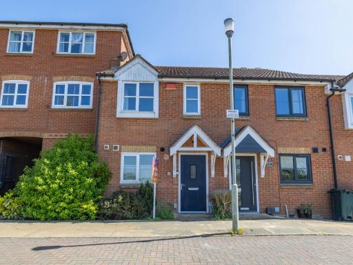 2 bedroom terraced house for sale in White Willow Close, Ashford, Kent, TN24 — £137,500 • 2 bed • 1 bath • 734 ft²
 2 bedroom flat for sale in Pipin Crescent, Finberry, Ashford, Kent, TN25 — £166,875 • 2 bed • 1 bath • 744 ft²
Meta
- {
"@context": "https://schema.org",
"@type": "Residence",
"name": "End of terrace house for sale in Bishop Crescent, Tenterden…",
"description": "",
"url": "https://propertypiper.co.uk/property/771e474d-80dd-4f4c-94dd-5695661cbfce",
"image": "https://image-a.propertypiper.co.uk/1b19dcb9-e359-458e-bde9-72a81aa3c218-1024.jpeg",
"address": {
"@type": "PostalAddress",
"streetAddress": "Bishop Crescent, Tenterden, Kent",
"postalCode": "TN30 7BF",
"addressLocality": "Ashford",
"addressRegion": "Ashford",
"addressCountry": "England"
},
"geo": {
"@type": "GeoCoordinates",
"latitude": 51.065272,
"longitude": 0.6873245
},
"numberOfRooms": 1,
"numberOfBathroomsTotal": 1,
"floorSize": {
"@type": "QuantitativeValue",
"value": 904,
"unitCode": "FTK"
},
"offers": {
"@type": "Offer",
"price": 112000,
"priceCurrency": "GBP",
"availability": "https://schema.org/InStock"
},
"additionalProperty": [
{
"@type": "PropertyValue",
"name": "Feature",
"value": "red brick"
},
{
"@type": "PropertyValue",
"name": "Feature",
"value": "detached"
},
{
"@type": "PropertyValue",
"name": "Feature",
"value": "modern traditional"
},
{
"@type": "PropertyValue",
"name": "Feature",
"value": "two-story"
},
{
"@type": "PropertyValue",
"name": "Feature",
"value": "gable roof"
},
{
"@type": "PropertyValue",
"name": "Feature",
"value": "white fence"
},
{
"@type": "PropertyValue",
"name": "Feature",
"value": "driveway"
},
{
"@type": "PropertyValue",
"name": "Feature",
"value": "front garden"
},
{
"@type": "PropertyValue",
"name": "Feature",
"value": "suburban"
},
{
"@type": "PropertyValue",
"name": "Feature",
"value": "modern living room"
},
{
"@type": "PropertyValue",
"name": "Feature",
"value": "standard ceiling"
},
{
"@type": "PropertyValue",
"name": "Feature",
"value": "electric fireplace"
},
{
"@type": "PropertyValue",
"name": "Feature",
"value": "beige walls"
},
{
"@type": "PropertyValue",
"name": "Feature",
"value": "neutral tones"
},
{
"@type": "PropertyValue",
"name": "Feature",
"value": "radiator heating"
},
{
"@type": "PropertyValue",
"name": "Feature",
"value": "corner placement"
},
{
"@type": "PropertyValue",
"name": "Feature",
"value": "carpet flooring"
}
]
}