SY1 3YY - 3 bedroom semidetached house for sale in Katesway, Herongat…
View on Property Piper
3 bedroom semi-detached house for sale in Katesway, Herongate, Shrewsbury, SY1
Property Details
- Price: £210000
- Bedrooms: 3
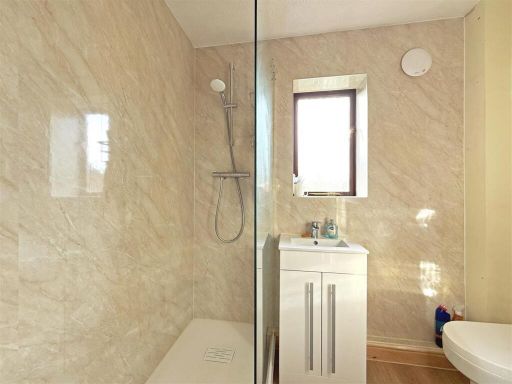
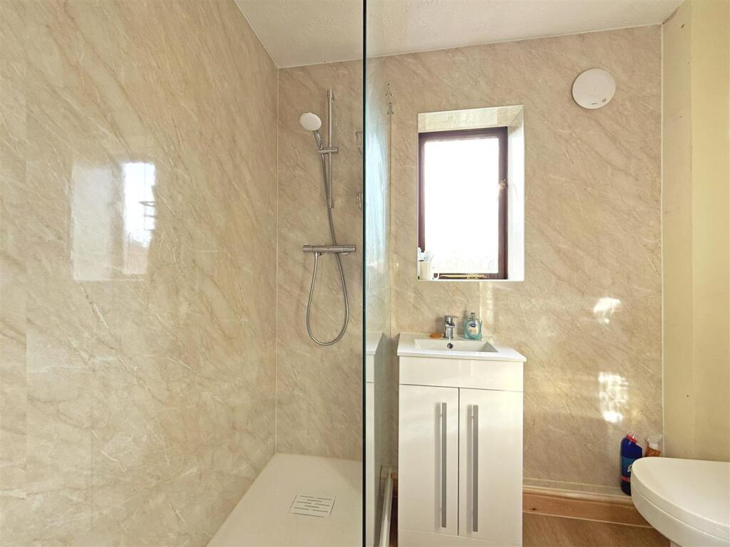
- Bathrooms: 1
- Property Type: undefined
- Property SubType: undefined
Brochure Descriptions
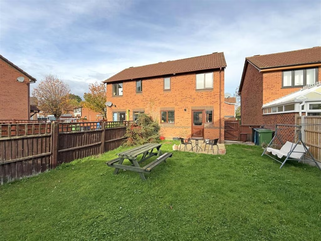
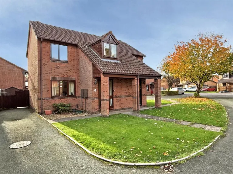
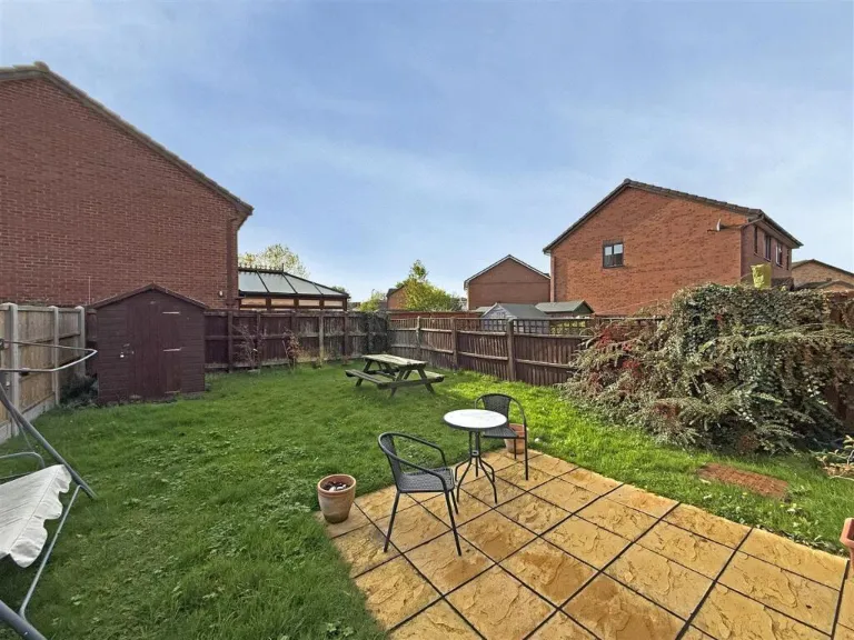
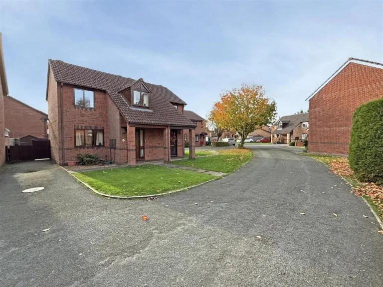
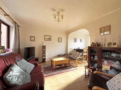
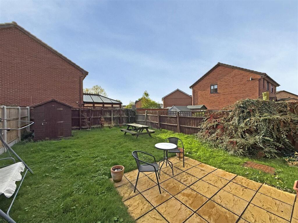
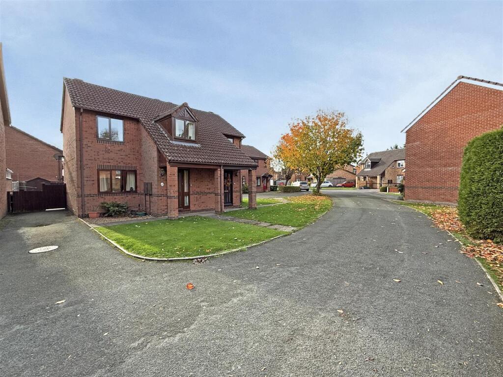
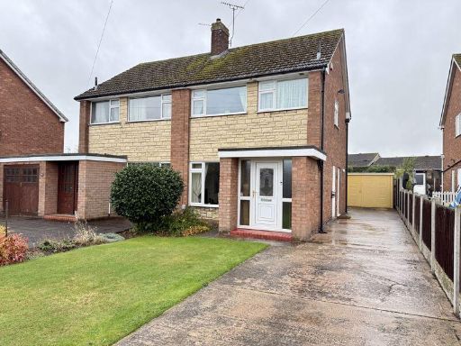
- Substantial two-storey, 3-bedroom semi‑detached house constructed in red brick with a tiled pitched roof and dormer to the front. Occupies a corner/cul‑de‑sac plot with a short front lawn, paved path to a covered porch, and a side driveway providing off‑street parking. Property appears in good external condition with potential to extend to the side or rear (subject to consent). Plot size: small/average front garden with an average‑sized rear garden likely (not visible). Overall property footprint: typical for a 3‑bed suburban semi‑detached dwelling. Suitable for owner‑occupiers or buy‑to‑let investors; good curb appeal and parking are positives. Shrewsbury location (SY1) will influence valuation; note the marketing price shown in the image of £210,000 (Freehold).
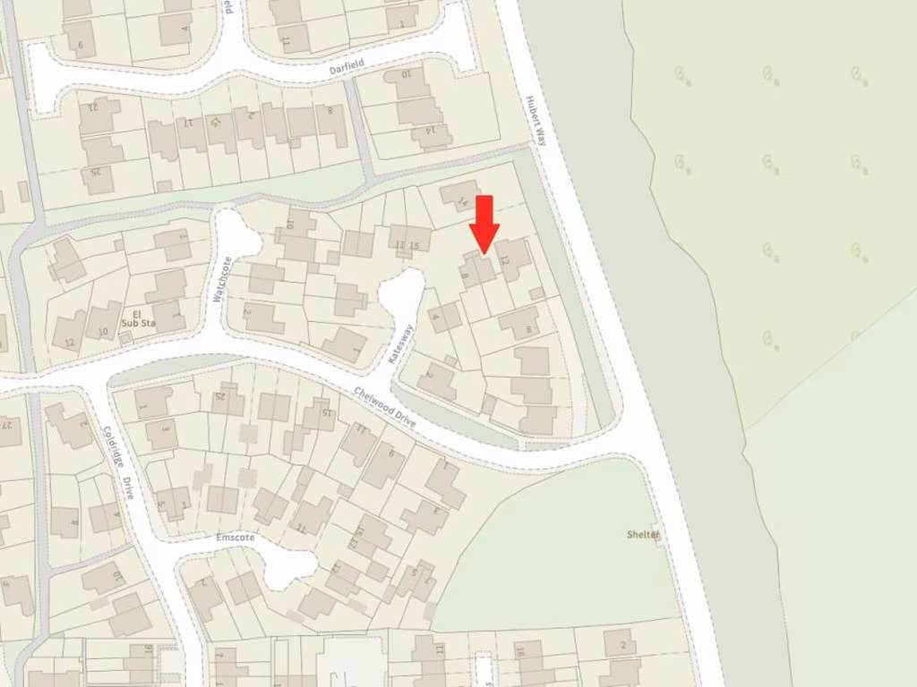
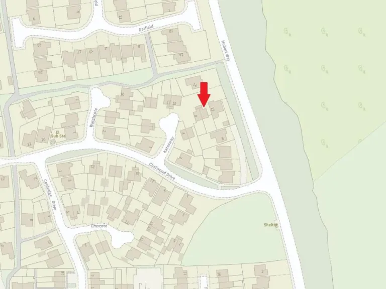
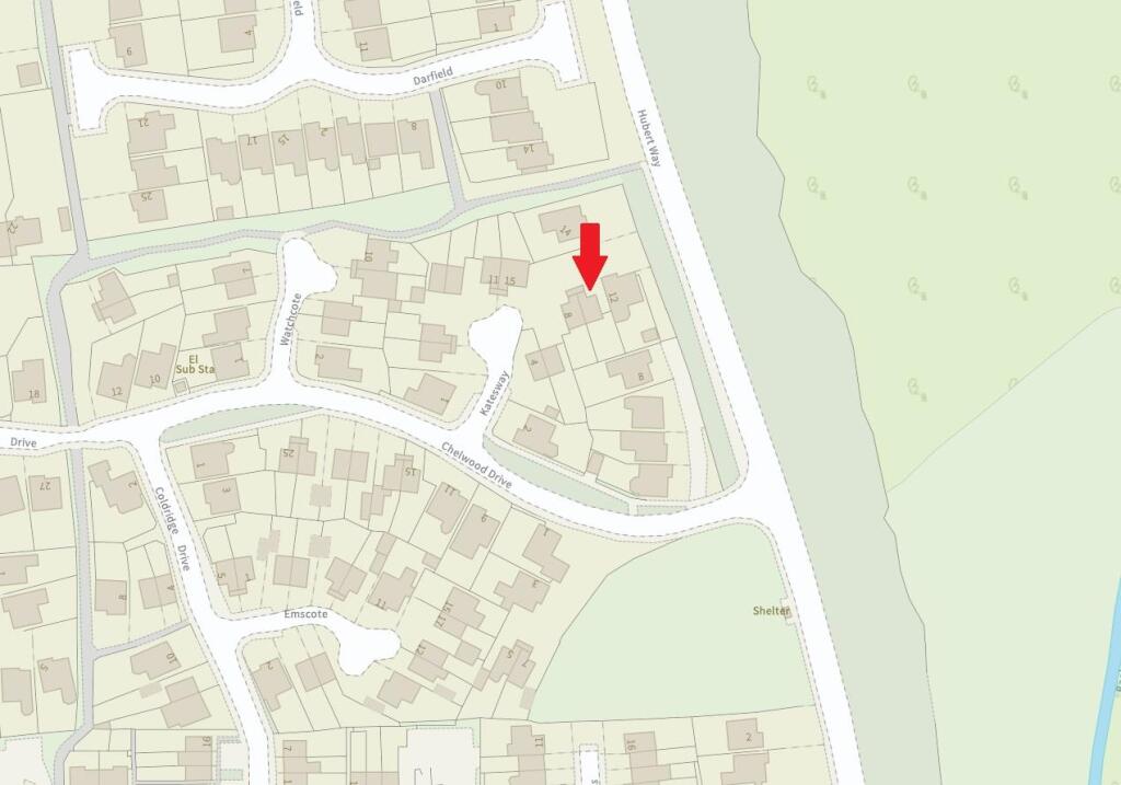
- Three-bedroom semi‑detached house offered Freehold in the Herongate area of Shrewsbury. The listing indicates a conventional mid‑terrace/semi layout (3 beds) likely suited to families or first‑time buyers. Location is shown on a town map close to significant green space and the River Severn corridor to the west/north‑west, suggesting pleasant local outlooks and access to recreational routes. Property appears to sit within an established residential neighbourhood with good road links into central Shrewsbury. From the information available the dwelling and garden are likely average in size for this suburb — suitable family accommodation with scope for modest updating. No internal photographs or floorplans provided on the image, so room configuration, finish and exact garden dimensions cannot be determined.
Image Descriptions
- exterior modern
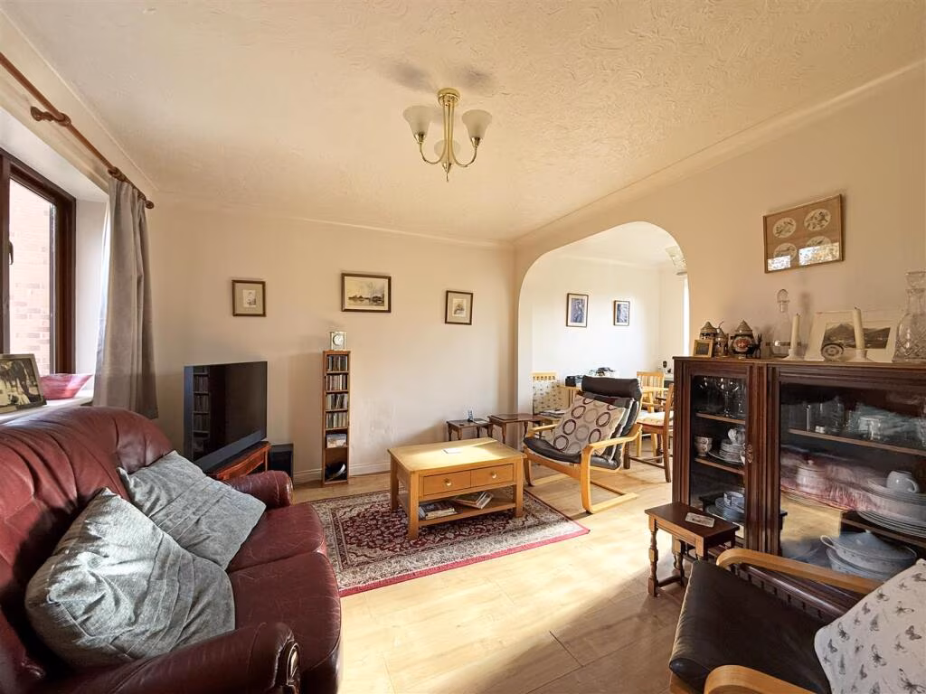
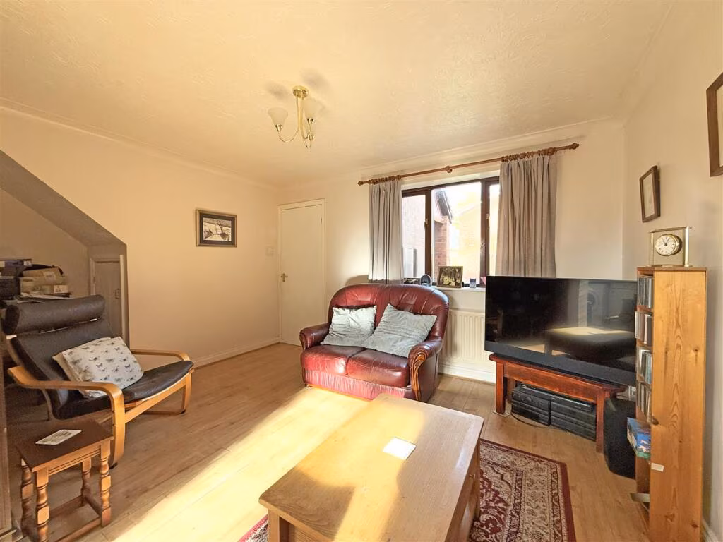
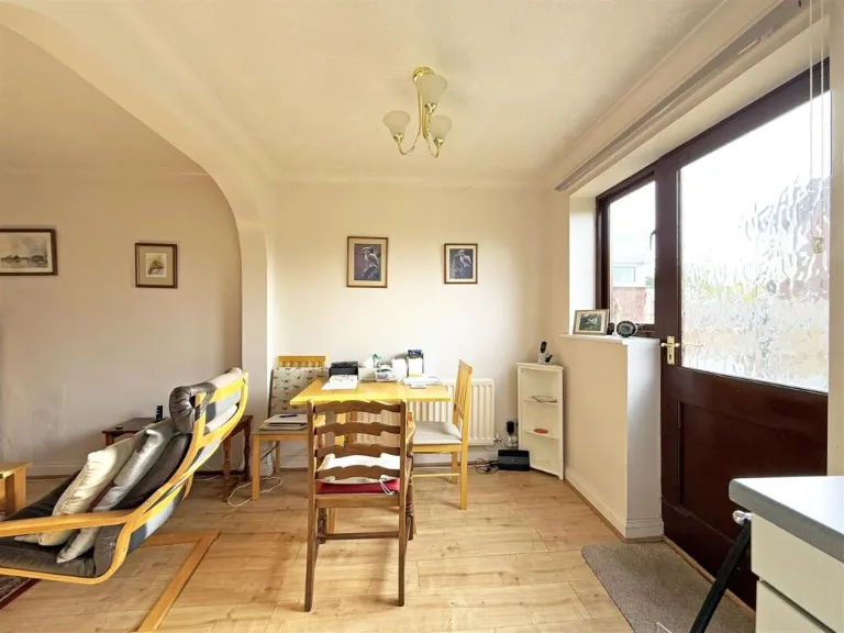
- living and dining area mid-20th century
Floorplan Description
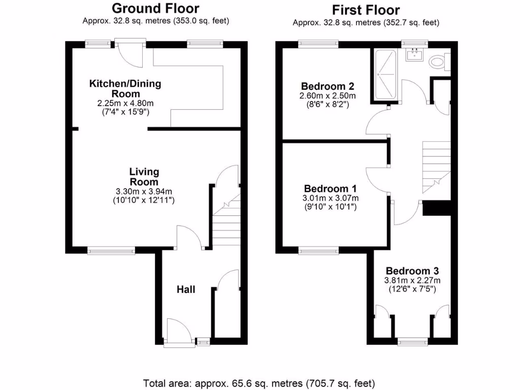
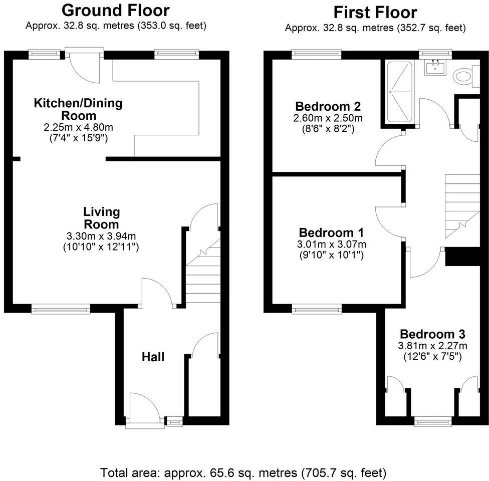
- Two-floor residential property with kitchen/dining, living room, hall and three bedrooms
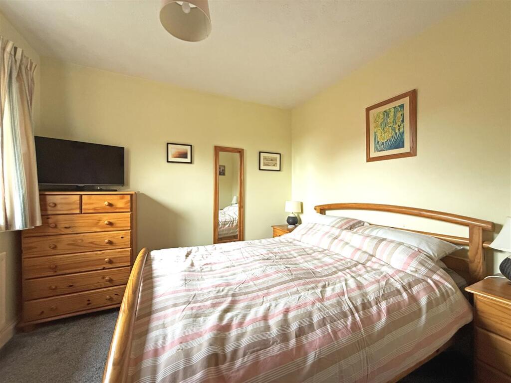
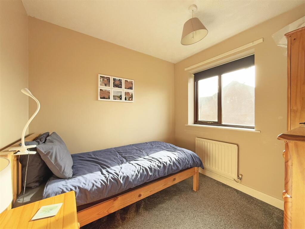
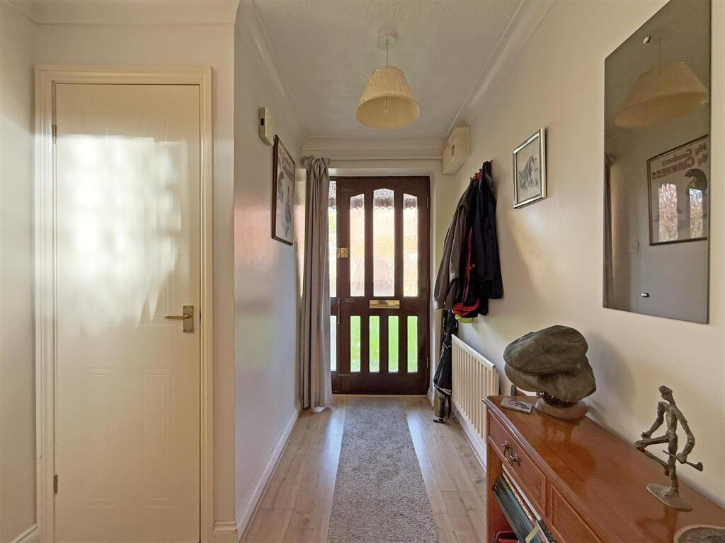
Rooms
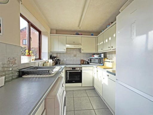
- Kitchen/Dining Room:
- Living Room:
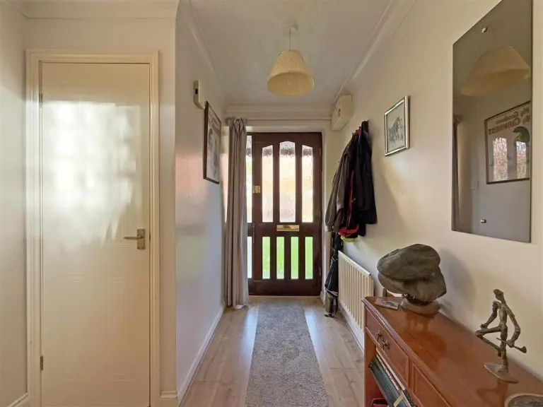
- Hall:
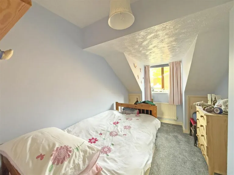
- Bedroom 2:
- Bedroom 1:
- Bedroom 3:
Textual Property Features
- Has Garden
- Chain Free
- Success
Detected Visual Features
- modern house
- pitched roof
- brick construction
- semi-detached
- two-story
- garage
- garden
- driveway
- suburban property
- living room
- dining area
- mid-20th century
- archway
- wooden flooring
- dual area
- natural light
- standard ceiling
EPC Details
- Fully double glazed
- Cavity wall, as built, insulated (assumed)
- Boiler and radiators, mains gas
- Low energy lighting in all fixed outlets
- Solid, no insulation (assumed)
Nearby Schools
- St Giles CofE Primary School
- The Martin Wilson School
- Grange Primary School
- Meole Brace Church of England Primary and Nursery
- Meole Brace School
- Coleham Primary School
- St George's Junior School
- Belvidere School
- Belvidere Primary School
- The Priory School
- Prestfelde School
- St Winefride's Convent School
- Woodfield Infant School
- Crowmoor Primary School and Nursery
- The Wilfred Owen School
- Greenfields Primary School
- Mereside Church of England Primary Academy
- Shrewsbury School
- Shrewsbury High School
- Mount Pleasant Primary
- Shrewsbury Academy
- Greenacres Primary School
Nearest Bars And Restaurants
- Id: 366855313
- Tags:
- Amenity: fast_food
- Building: yes
- Cuisine: chinese
- Name: Tasty Food
- TagsNormalized:
- Lat: 52.7238952
- Lon: -2.738357
- FullGeoHash: gcq5cwjfzwmj
- PartitionGeoHash: gcq5
- Images:
- FoodStandards: null
- Distance: 628.8
,- Id: 366850812
- Tags:
- Amenity: fast_food
- Building: yes
- Cuisine: fish_and_chips
- Name: The Sea Fryer
- TagsNormalized:
- Lat: 52.7224707
- Lon: -2.7392937
- FullGeoHash: gcq5ctv69ufs
- PartitionGeoHash: gcq5
- Images:
- FoodStandards: null
- Distance: 608.5
,- Id: 366850811
- Tags:
- Amenity: fast_food
- Building: yes
- Cuisine: chinese
- Name: Mandarin Chef
- Source: survey
- TagsNormalized:
- Lat: 52.7225412
- Lon: -2.7392711
- FullGeoHash: gcq5ctv74652
- PartitionGeoHash: gcq5
- Images:
- FoodStandards: null
- Distance: 606.9
,- Id: 366948104
- Tags:
- Amenity: pub
- Building: yes
- Name: The Coach
- Opening_hours: Mo-Th 11:00-23:00; Fr,Sa 11:00-24:00; Su 12:00-23:30
- TagsNormalized:
- Lat: 52.7225111
- Lon: -2.7398808
- FullGeoHash: gcq5ctufuhkv
- PartitionGeoHash: gcq5
- Images:
- FoodStandards: null
- Distance: 570.4
,- Id: 456172247
- Tags:
- Amenity: pub
- Name: The Compasses Inn
- TagsNormalized:
- Lat: 52.7254405
- Lon: -2.7400089
- FullGeoHash: gcq5cwkgcnmr
- PartitionGeoHash: gcq5
- Images:
- FoodStandards: null
- Distance: 521.5
}
Nearest General Shops
- Id: 6022543853
- Tags:
- Name: Loans2Go
- Shop: money_lender
- Source: mapillary
- Website: https://loans2go.co.uk/locations/shrewsbury-loans-2-go/
- TagsNormalized:
- Lat: 52.7243623
- Lon: -2.7386181
- FullGeoHash: gcq5cwjv9t6r
- PartitionGeoHash: gcq5
- Images:
- FoodStandards: null
- Distance: 607
,- Id: 3708320066
- Tags:
- TagsNormalized:
- Lat: 52.7227063
- Lon: -2.7391967
- FullGeoHash: gcq5ctvkh0fc
- PartitionGeoHash: gcq5
- Images:
- FoodStandards: null
- Distance: 604.9
,- Id: 366855310
- Tags:
- Addr:
- Housenumber: 43
- Street: Ditherington Road
- Building: yes
- Name: Cyclelife - Shrewsbury Cycles
- Phone: +44 1743 232061
- Shop: bicycle
- Website: https://shrewsburycycles.co.uk/
- TagsNormalized:
- Lat: 52.7239308
- Lon: -2.738874
- FullGeoHash: gcq5cwje5t59
- PartitionGeoHash: gcq5
- Images:
- FoodStandards: null
- Distance: 593.8
}
Nearest Grocery shops
- Id: 366946194
- Tags:
- Brand: Costcutter
- Brand:wikidata: Q5175072
- Brand:wikipedia: en:Costcutter
- Building: yes
- Name: Costcutter
- Shop: convenience
- TagsNormalized:
- costcutter
- convenience
- shop
- Lat: 52.7264304
- Lon: -2.7383409
- FullGeoHash: gcq5cww18p10
- PartitionGeoHash: gcq5
- Images:
- FoodStandards: null
- Distance: 657.8
,- Id: 366850816
- Tags:
- Brand: One Stop
- Brand:wikidata: Q65954217
- Building: yes
- Name: One Stop
- Operator: One Stop
- Shop: convenience
- TagsNormalized:
- Lat: 52.7227123
- Lon: -2.739014
- FullGeoHash: gcq5ctvs03gj
- PartitionGeoHash: gcq5
- Images:
- FoodStandards: null
- Distance: 616.3
,- Id: 639097601
- Tags:
- Addr:
- City: Shrewsbury
- Housenumber: 59
- Postcode: SY1 4BD
- Street: Ditherington Road
- Brand: Tesco Express
- Brand:wikidata: Q98456772
- Brand:wikipedia: en:Tesco
- Building: retail
- Contact:
- Website: https://www.tesco.com/store-locator/shrewsbury/ditherington-rd
- Fhrs:
- Name: Tesco Express
- Shop: convenience
- Source:
- TagsNormalized:
- tesco
- tesco express
- retail
- convenience
- shop
- Lat: 52.7244815
- Lon: -2.7386403
- FullGeoHash: gcq5cwjy359y
- PartitionGeoHash: gcq5
- Images:
- FoodStandards:
- Id: 352744
- FHRSID: 352744
- LocalAuthorityBusinessID: 199420
- BusinessName: Tesco Express
- BusinessType: Retailers - supermarkets/hypermarkets
- BusinessTypeID: 7840
- AddressLine1: 59 Ditherington Road
- AddressLine2: Shrewsbury
- AddressLine3: Shropshire
- AddressLine4: null
- PostCode: SY1 4BD
- RatingValue: 5
- RatingKey: fhrs_5_en-GB
- RatingDate: 2019-03-25
- LocalAuthorityCode: 708
- LocalAuthorityName: Shropshire
- LocalAuthorityWebSite: http://www.shropshire.gov.uk/foodhygienescheme
- LocalAuthorityEmailAddress: food@shropshire.gov.uk
- Scores:
- Hygiene: 5
- Structural: 5
- ConfidenceInManagement: 5
- NewRatingPending: false
- Geocode:
- Longitude: -2.73838500000000
- Latitude: 52.72468200000000
- Distance: 605.1
}
Nearest Supermarkets
- Id: 200714912
- Tags:
- Addr:
- Housename: Cattle Market
- Postcode: SY1 4HA
- Street: Battlefield Road
- Brand: Tesco Extra
- Brand:wikidata: Q25172225
- Brand:wikipedia: en:Tesco Extra
- Building: commercial
- Contact:
- Website: https://www.tesco.com/store-locator/shrewsbury/cattle-market
- Name: Tesco Extra
- Opening_hours: Mo-Sa 06:00-24:00; Su 10:00-16:00
- Shop: supermarket
- TagsNormalized:
- tesco
- tesco extra
- supermarket
- shop
- Lat: 52.7379186
- Lon: -2.7255698
- FullGeoHash: gcqh1bxk9sef
- PartitionGeoHash: gcqh
- Images:
- FoodStandards: null
- Distance: 2098.1
,- Id: 200715154
- Tags:
- Addr:
- Country: GB
- Postcode: SY1 3AA
- Street: Whitchurch Road
- Brand: Lidl
- Brand:wikidata: Q151954
- Brand:wikipedia: en:Lidl
- Building: yes
- Fhrs:
- Name: Lidl
- Shop: supermarket
- TagsNormalized:
- Lat: 52.7362795
- Lon: -2.7257557
- FullGeoHash: gcqh1br5j710
- PartitionGeoHash: gcqh
- Images:
- FoodStandards:
- Id: 126007
- FHRSID: 126007
- LocalAuthorityBusinessID: 54742
- BusinessName: Lidl
- BusinessType: Retailers - supermarkets/hypermarkets
- BusinessTypeID: 7840
- AddressLine1: Whitchurch Road
- AddressLine2: Shrewsbury
- AddressLine3: Shropshire
- AddressLine4: null
- PostCode: SY1 3AA
- RatingValue: 5
- RatingKey: fhrs_5_en-GB
- RatingDate: 2016-12-06
- LocalAuthorityCode: 708
- LocalAuthorityName: Shropshire
- LocalAuthorityWebSite: http://www.shropshire.gov.uk/foodhygienescheme
- LocalAuthorityEmailAddress: food@shropshire.gov.uk
- Scores:
- Hygiene: 5
- Structural: 5
- ConfidenceInManagement: 5
- NewRatingPending: false
- Geocode:
- Longitude: -2.72602900000000
- Latitude: 52.73667000000000
- Distance: 1964.2
,- Id: 155052635
- Tags:
- Addr:
- Postcode: SY1 4DL
- Street: Whitchurch Road
- Brand: Morrisons
- Brand:wikidata: Q922344
- Brand:wikipedia: en:Morrisons
- Building: yes
- Contact:
- Website: https://my.morrisons.com/storefinder/68
- Name: Morrisons
- Shop: supermarket
- TagsNormalized:
- Lat: 52.7290369
- Lon: -2.7359306
- FullGeoHash: gcq5cxpbbhyk
- PartitionGeoHash: gcq5
- Images:
- FoodStandards: null
- Distance: 929.9
}
Nearest Religious buildings
- Id: 860099828
- Tags:
- Amenity: place_of_worship
- Building: church
- Denomination: anglican
- Name: All Saints Church
- Religion: christian
- Wikidata: Q26538760
- TagsNormalized:
- place of worship
- church
- anglican
- christian
- Lat: 52.7141658
- Lon: -2.7432511
- FullGeoHash: gcq5cs66m8ex
- PartitionGeoHash: gcq5
- Images:
- FoodStandards: null
- Distance: 1195.8
,- Id: 985156594
- Tags:
- Addr:
- City: Shrewsbury
- Postcode: SY1 2RZ
- Street: John Street
- Amenity: place_of_worship
- Building: yes
- Name: Johns Street Church
- Religion: christian
- Website: https://www.johnstreetchurchshrewsbury.co.uk/
- TagsNormalized:
- place of worship
- church
- christian
- Lat: 52.7158929
- Lon: -2.7430522
- FullGeoHash: gcq5csds668j
- PartitionGeoHash: gcq5
- Images:
- FoodStandards: null
- Distance: 1014.8
,- Id: 118371931
- Tags:
- Amenity: place_of_worship
- Denomination: methodist;anglican
- Name: Greenfields Church
- Religion: christian
- TagsNormalized:
- place of worship
- methodist
- anglican
- church
- christian
- Lat: 52.7192972
- Lon: -2.7513259
- FullGeoHash: gcq5cmk81mq9
- PartitionGeoHash: gcq5
- Images:
- FoodStandards: null
- Distance: 639.1
}
Nearest Medical buildings
- Id: 1771507952
- Tags:
- Amenity: pharmacy
- Brand: Lloyds Pharmacy
- Brand:wikidata: Q6662870
- Brand:wikipedia: en:LloydsPharmacy
- Healthcare: pharmacy
- Name: Lloyds Pharmacy
- TagsNormalized:
- pharmacy
- lloyds pharmacy
- health
- healthcare
- Lat: 52.7103179
- Lon: -2.7545493
- FullGeoHash: gcq5c7d5y77j
- PartitionGeoHash: gcq5
- Images:
- FoodStandards: null
- Distance: 1654
,- Id: 9711049344
- Tags:
- Addr:
- City: Shrewsbury
- Housenumber: 76
- Postcode: SY1 2DP
- Street: Coton Hill
- Amenity: dentist
- Email: info@winchesterhousedental.co.uk
- Healthcare: dentist
- Name: Winchester House Dental Practice
- Opening_hours: Mo-Fr 08:15-17:00; Th 08:15-19:30; PH off
- Phone: +441743 362326
- Website: https://winchesterhousedental.co.uk/
- TagsNormalized:
- dentist
- health
- healthcare
- dental
- Lat: 52.7136534
- Lon: -2.7521004
- FullGeoHash: gcq5ck5zr3jn
- PartitionGeoHash: gcq5
- Images:
- FoodStandards: null
- Distance: 1252.8
,- Id: 202799762
- Tags:
- Addr:
- Housename: St Michael's Clinic
- Postcode: SY1 2HE
- Street: St Michael's Street
- Amenity: clinic
- Beauty: skin_care
- Building: yes
- Building:levels: 2
- Healthcare: clinic
- Healthcare:speciality: dermatology
- Name: St Michael's Clinic
- Opening_hours: Mo 08:30-18:00; Tu-Fr 09:00-17:00; PH off
- Roof:
- Source: Bing
- Website: https://www.stmichaelsclinic.co.uk/
- TagsNormalized:
- Lat: 52.7175187
- Lon: -2.7453101
- FullGeoHash: gcq5csbvv9u2
- PartitionGeoHash: gcq5
- Images:
- FoodStandards: null
- Distance: 801.5
,- Id: 3290869674
- Tags:
- Amenity: pharmacy
- Brand: Well Pharmacy
- Brand:wikidata: Q7726524
- Dispensing: yes
- Healthcare: pharmacy
- Name: Well Pharmacy
- TagsNormalized:
- pharmacy
- well pharmacy
- health
- healthcare
- Lat: 52.7301677
- Lon: -2.7430167
- FullGeoHash: gcq5cx4x7pdw
- PartitionGeoHash: gcq5
- Images:
- FoodStandards: null
- Distance: 693.6
}
Nearest Leisure Facilities
- Id: 367307317
- Tags:
- Access: private
- Leisure: pitch
- Sport: bowls
- Surface: grass
- TagsNormalized:
- Lat: 52.7200228
- Lon: -2.7468231
- FullGeoHash: gcq5cmru6ks1
- PartitionGeoHash: gcq5
- Images:
- FoodStandards: null
- Distance: 510.6
,- Id: 38420728
- Tags:
- TagsNormalized:
- Lat: 52.7205351
- Lon: -2.7475666
- FullGeoHash: gcq5cmrr3h1c
- PartitionGeoHash: gcq5
- Images:
- FoodStandards: null
- Distance: 450.8
,- Id: 548754937
- Tags:
- Bicycle: yes
- Leisure: track
- Lit: no
- Sport: bmx
- Surface: ground
- TagsNormalized:
- Lat: 52.7212349
- Lon: -2.7452751
- FullGeoHash: gcq5ct8gqqw8
- PartitionGeoHash: gcq5
- Images:
- FoodStandards: null
- Distance: 405.1
,- Id: 38420729
- Tags:
- Hoops: 2
- Leisure: pitch
- Lit: no
- Sport: basketball;soccer
- TagsNormalized:
- pitch
- leisure
- basketball
- soccer
- sports
- Lat: 52.7212801
- Lon: -2.7456496
- FullGeoHash: gcq5ct8etwzm
- PartitionGeoHash: gcq5
- Images:
- FoodStandards: null
- Distance: 391.2
,- Id: 941739852
- Tags:
- Access: private
- Garden:
- Leisure: garden
- Meadow: orchard
- TagsNormalized:
- Lat: 52.721654
- Lon: -2.7446415
- FullGeoHash: gcq5ct9mvhwu
- PartitionGeoHash: gcq5
- Images:
- FoodStandards: null
- Distance: 383.2
}
Nearest Tourist attractions
- Id: 6944201
- Tags:
- Addr:
- City: Shrewsbury
- Postcode: SY1 2HR
- Street: The Dana
- Attraction: prison
- Historic: yes
- Name: The Dana
- Tourism: attraction
- Type: multipolygon
- Website: https://www.jailhousetours.com/
- TagsNormalized:
- Lat: 52.7122287
- Lon: -2.7475197
- FullGeoHash: gcq5c7zqfpsu
- PartitionGeoHash: gcq5
- Images:
- FoodStandards: null
- Distance: 1374.4
,- Id: 1520113898
- Tags:
- Name: Sydney House B&B
- Tourism: guest_house
- TagsNormalized:
- Lat: 52.7164353
- Lon: -2.7531609
- FullGeoHash: gcq5ckepqxy3
- PartitionGeoHash: gcq5
- Images:
- FoodStandards: null
- Distance: 980.3
,- Id: 639096924
- Tags:
- Building: yes
- Name: Ditherington Flax Mill
- Note: video & displays
- Operator: Friends of Ditherington Flax Mill
- Tourism: museum
- TagsNormalized:
- Lat: 52.7193847
- Lon: -2.7442804
- FullGeoHash: gcq5ct38tts5
- PartitionGeoHash: gcq5
- Images:
- FoodStandards: null
- Distance: 621
}
Nearest Train stations
- Id: 367981086
- Tags:
- Name: Horsehay & Dawley
- Public_transport: station
- Railway: station
- Usage: tourism
- Wikidata: Q28970323
- TagsNormalized:
- Lat: 52.6629789
- Lon: -2.4816699
- FullGeoHash: gcq5xe0bhfuc
- PartitionGeoHash: gcq5
- Images:
- FoodStandards: null
- Distance: 19187.9
,- Id: 814684302
- Tags:
- Name: Spring Village
- Public_transport: station
- Railway: station
- Usage: tourism
- TagsNormalized:
- Lat: 52.6628632
- Lon: -2.4825389
- FullGeoHash: gcq5xdbr2thz
- PartitionGeoHash: gcq5
- Images:
- FoodStandards: null
- Distance: 19137.9
,- Id: 3711424258
- Tags:
- Name: Wellington
- Naptan:
- Network: National Rail
- Public_transport: station
- Railway: station
- Ref:
- Wheelchair: yes
- Wikidata: Q1851350
- Wikipedia: en:Wellington railway station (Shropshire)
- TagsNormalized:
- Lat: 52.7014362
- Lon: -2.5167193
- FullGeoHash: gcq5ydp2h5y0
- PartitionGeoHash: gcq5
- Images:
- FoodStandards: null
- Distance: 15766
,- Id: 1080583465
- Tags:
- Name: Wem
- Naptan:
- Network: National Rail
- Operator: Trafnidiaeth Cymru
- Operator:cy: Trafnidiaeth Cymru
- Operator:en: Transport for Wales
- Platforms: 2
- Public_transport: station
- Railway: station
- Ref:
- Source: Local Knowledge
- Wheelchair: yes
- Wikidata: Q2557796
- Wikipedia: en:Wem railway station
- TagsNormalized:
- Lat: 52.8561108
- Lon: -2.7182651
- FullGeoHash: gcqhdnht5v4w
- PartitionGeoHash: gcqh
- Images:
- FoodStandards: null
- Distance: 14757.2
,- Id: 5071836748
- Tags:
- Name: Shrewsbury
- Name:cy: Yr Amwythig
- Naptan:
- Network: National Rail
- Old_name: Shrewsbury General
- Operator: Trafnidiaeth Cymru
- Operator:cy: Trafnidiaeth Cymru
- Operator:en: Transport for Wales
- Public_transport: station
- Railway: station
- Railway:etcs: 2
- Ref:
- Wheelchair: yes
- Wikidata: Q1911181
- Wikipedia: en:Shrewsbury railway station
- TagsNormalized:
- Lat: 52.7118509
- Lon: -2.7494043
- FullGeoHash: gcq5c7vuy1pw
- PartitionGeoHash: gcq5
- Images:
- FoodStandards: null
- Distance: 1421.5
}
Nearest Bus stations and stops
- Id: 447878286
- Tags:
- Bench: no
- Bin: no
- Bus: yes
- Highway: bus_stop
- Mapillary: 772670136638461
- Public_transport: platform
- Shelter: no
- Survey:
- TagsNormalized:
- Lat: 52.7204382
- Lon: -2.7416076
- FullGeoHash: gcq5ct7wgcvp
- PartitionGeoHash: gcq5
- Images:
- FoodStandards: null
- Distance: 614.2
,- Id: 493637417
- Tags:
- Bin: yes
- Bus: yes
- Covered: yes
- Highway: bus_stop
- Name: Comet Drive
- Public_transport: platform
- TagsNormalized:
- Lat: 52.7230926
- Lon: -2.7390409
- FullGeoHash: gcq5ctvqr8z1
- PartitionGeoHash: gcq5
- Images:
- FoodStandards: null
- Distance: 601.5
,- Id: 493637438
- Tags:
- Bench: no
- Bin: no
- Bus: yes
- Highway: bus_stop
- Mapillary: 303322847956808
- Name: The Coach
- Public_transport: platform
- Shelter: no
- Survey:
- TagsNormalized:
- Lat: 52.7225878
- Lon: -2.7396006
- FullGeoHash: gcq5ctv56dtw
- PartitionGeoHash: gcq5
- Images:
- FoodStandards: null
- Distance: 584.4
,- Id: 493637390
- Tags:
- Bus: yes
- Highway: bus_stop
- Public_transport: platform
- TagsNormalized:
- Lat: 52.727209
- Lon: -2.7405533
- FullGeoHash: gcq5cwsqk2pm
- PartitionGeoHash: gcq5
- Images:
- FoodStandards: null
- Distance: 558.2
,- Id: 5275547731
- Tags:
- Bench: yes
- Bus: yes
- Highway: bus_stop
- Public_transport: platform
- Shelter: yes
- TagsNormalized:
- Lat: 52.7238349
- Lon: -2.7467774
- FullGeoHash: gcq5cqpfe7nm
- PartitionGeoHash: gcq5
- Images:
- FoodStandards: null
- Distance: 101.4
}
Nearest Hotels
- Id: 187923792
- Tags:
- Addr:
- Amenity: pub
- Brand: Wetherspoon
- Brand:wikidata: Q6109362
- Brand:wikipedia: en:Wetherspoons
- Cider: real
- Contact:
- Website: https://www.jdwetherspoon.com/pubs/all-pubs/england/shropshire/the-shrewsbury-hotel-shrewsbury
- Food: yes
- Name: The Shrewsbury Hotel
- Outdoor_seating: yes
- Parking: yes
- Real_ale: yes
- Toilets: yes
- Toilets:wheelchair: yes
- Wheelchair: yes
- TagsNormalized:
- Lat: 52.7094425
- Lon: -2.7572029
- FullGeoHash: gcq5c72qb80x
- PartitionGeoHash: gcq5
- Images:
- FoodStandards: null
- Distance: 1803.6
,- Id: 307905320
- Tags:
- Addr:
- City: Shrewsbury
- Postcode: SY1 1QB
- Street: Smithfield Road
- Brand: Premier Inn
- Brand:wikidata: Q2108626
- Brand:wikipedia: en:Premier Inn
- Building: yes
- Building:levels: 5
- Fhrs:
- Internet_access: wlan
- Internet_access:fee: customers
- Internet_access:operator: Virgin Media
- Internet_access:ssid: Premier Inn Free Wi-Fi
- Name: Premier Inn
- Operator: Premier Inns
- Smoking: no
- Source:
- Tourism: hotel
- Wheelchair: yes
- TagsNormalized:
- Lat: 52.7107644
- Lon: -2.7533261
- FullGeoHash: gcq5c7en6yem
- PartitionGeoHash: gcq5
- Images:
- FoodStandards: null
- Distance: 1584.5
,- Id: 2050027346
- Tags:
- Addr:
- Housenumber: 4
- Postcode: SY1 2DJ
- Street: Castle Foregate
- Fhrs:
- Name: Station Hotel
- Source:
- Tourism: hotel
- TagsNormalized:
- Lat: 52.7118508
- Lon: -2.7504925
- FullGeoHash: gcq5c7vhuchj
- PartitionGeoHash: gcq5
- Images:
- FoodStandards: null
- Distance: 1429.5
}
Tags
- modern house
- pitched roof
- brick construction
- semi-detached
- two-story
- garage
- garden
- driveway
- suburban property
- living room
- dining area
- mid-20th century
- archway
- wooden flooring
- dual area
- natural light
- standard ceiling
Local Market Stats
- Average Price/sqft: £247
- Avg Income: £40700
- Rental Yield: 4%
- Social Housing: 17%
- Planning Success Rate: 89%
AirBnB Data
- 1km average: £63/night
- Listings in 1km: 2
Similar Properties
 3 bedroom semi-detached house for sale in Leamore Crescent, Belle Vue, Shrewsbury, SY3 7QD, SY3 — £260,000 • 3 bed • 1 bath
 3 bedroom semi-detached house for sale in Murrell Way, Off Oteley Road, Shrewsbury, SY2 6FN, SY2 — £290,000 • 3 bed • 2 bath
 3 bedroom semi-detached house for sale in 4 Well Meadow Gardens, Shrewsbury, SY3 8UP, SY3 — £389,995 • 3 bed • 1 bath • 784 ft²
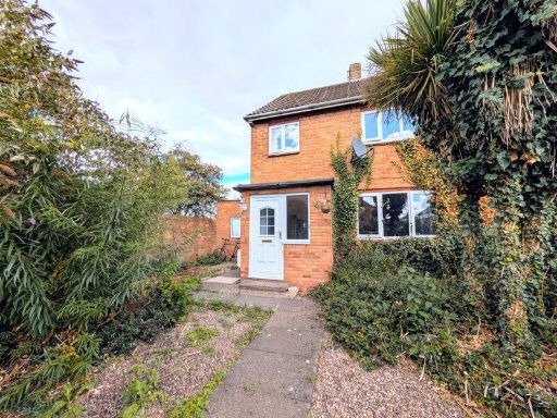 3 bedroom semi-detached house for sale in Judith Butts Gardens, Monkmoor, Shrewsbury, SY2 5RZ, SY2 — £205,000 • 3 bed • 1 bath
 3 bedroom semi-detached house for sale in Fox Avenue, Shrewsbury, SY2 — £280,000 • 3 bed • 2 bath • 640 ft²
 3 bedroom semi-detached house for sale in Lydham Road, Heath Farm, Shrewsbury, SY1 — £290,000 • 3 bed • 1 bath • 1221 ft²
Meta
- {
"@context": "https://schema.org",
"@type": "Residence",
"name": "3 bedroom semidetached house for sale in Katesway, Herongat…",
"description": "",
"url": "https://propertypiper.co.uk/property/75bb2fef-7437-4a8f-b24e-670cb9e002a1",
"image": "https://image-a.propertypiper.co.uk/ea6ef314-deb8-4384-a685-dd3a5b0ba191-1024.jpeg",
"address": {
"@type": "PostalAddress",
"streetAddress": "10 KATESWAY SHREWSBURY",
"postalCode": "SY1 3YY",
"addressLocality": "Shropshire",
"addressRegion": "Shrewsbury and Atcham",
"addressCountry": "England"
},
"geo": {
"@type": "GeoCoordinates",
"latitude": 52.72458893524044,
"longitude": -2.7476241142939073
},
"numberOfRooms": 3,
"numberOfBathroomsTotal": 1,
"floorSize": {
"@type": "QuantitativeValue",
"value": 706,
"unitCode": "FTK"
},
"offers": {
"@type": "Offer",
"price": 210000,
"priceCurrency": "GBP",
"availability": "https://schema.org/InStock"
},
"additionalProperty": [
{
"@type": "PropertyValue",
"name": "Feature",
"value": "modern house"
},
{
"@type": "PropertyValue",
"name": "Feature",
"value": "pitched roof"
},
{
"@type": "PropertyValue",
"name": "Feature",
"value": "brick construction"
},
{
"@type": "PropertyValue",
"name": "Feature",
"value": "semi-detached"
},
{
"@type": "PropertyValue",
"name": "Feature",
"value": "two-story"
},
{
"@type": "PropertyValue",
"name": "Feature",
"value": "garage"
},
{
"@type": "PropertyValue",
"name": "Feature",
"value": "garden"
},
{
"@type": "PropertyValue",
"name": "Feature",
"value": "driveway"
},
{
"@type": "PropertyValue",
"name": "Feature",
"value": "suburban property"
},
{
"@type": "PropertyValue",
"name": "Feature",
"value": "living room"
},
{
"@type": "PropertyValue",
"name": "Feature",
"value": "dining area"
},
{
"@type": "PropertyValue",
"name": "Feature",
"value": "mid-20th century"
},
{
"@type": "PropertyValue",
"name": "Feature",
"value": "archway"
},
{
"@type": "PropertyValue",
"name": "Feature",
"value": "wooden flooring"
},
{
"@type": "PropertyValue",
"name": "Feature",
"value": "dual area"
},
{
"@type": "PropertyValue",
"name": "Feature",
"value": "natural light"
},
{
"@type": "PropertyValue",
"name": "Feature",
"value": "standard ceiling"
}
]
}
High Res Floorplan Images
Compatible Floorplan Images
FloorplanImages Thumbnail