B60 3ED - 4 bedroom detached house for sale in Stoke Road, Bromsgrove…
View on Property Piper
4 bedroom detached house for sale in Stoke Road, Bromsgrove, Worcestershire, B60
Property Details
- Price: £585000
- Bedrooms: 4
- Bathrooms: 2
- Property Type: undefined
- Property SubType: undefined
Brochure Descriptions
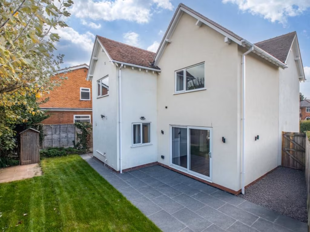
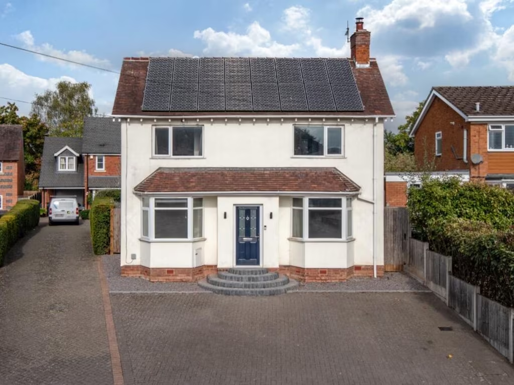
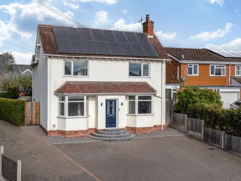
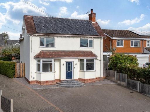
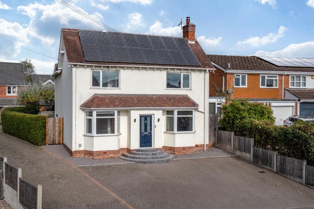
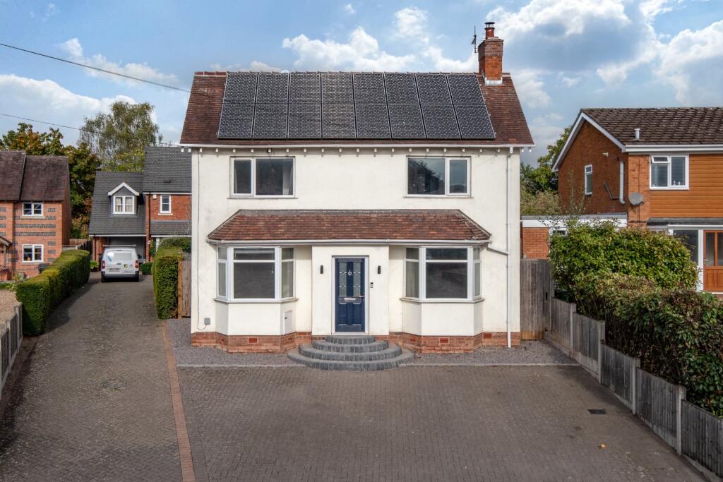
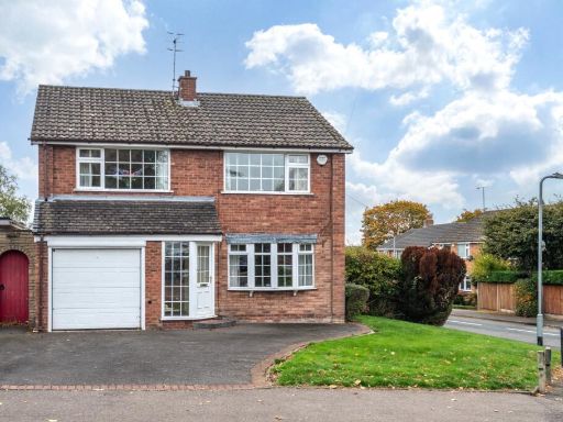
- Detached two-storey family residence presented in good order. The house features a symmetrical frontage with twin bay windows either side of a central entrance, tiled porch canopy and large paved driveway providing off-street parking for multiple vehicles. Solar panels are fitted to the main roof, indicating reduced running costs. The plot appears to be of average depth with modest front garden areas and side access gates; neighbouring properties are similar semi-urban family homes. Internal layout likely comprises ground-floor reception rooms to the front, with bedrooms to the first floor (typical 3–4 bedroom arrangement inferred from scale). Overall property size is medium — suitable for a family — with no prominent long-distance views visible (residential street outlook).
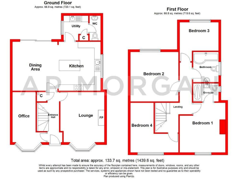
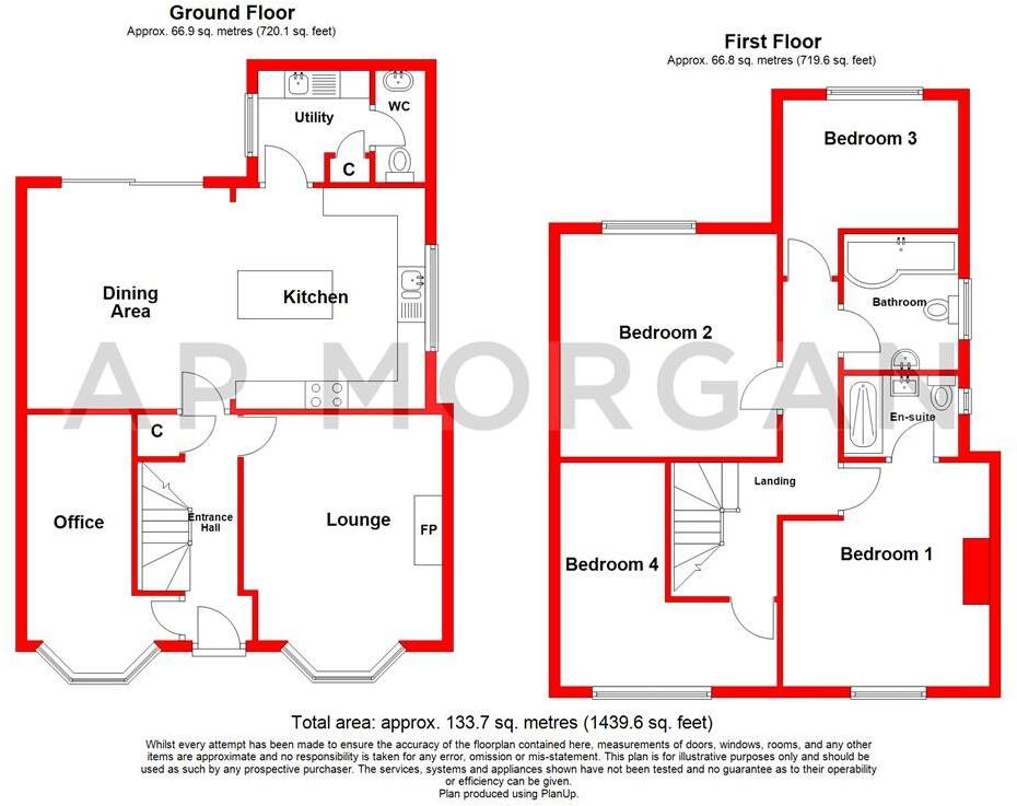
- Two-storey detached family house as shown on the floorplan. Ground floor layout includes entrance hall, lounge, open-plan dining area with adjoining kitchen, a separate office/study, utility room and downstairs WC. First floor provides three bedrooms (one principal bedroom with en-suite layout indicated) plus a family bathroom. Internal layout is regular and efficient with good-sized reception spaces and a study suitable for home-working. Based on the plan scale the property footprint and room proportions indicate an average/medium sized family home with a modest to medium private garden (not shown in detail). No notable external views are visible on the image.
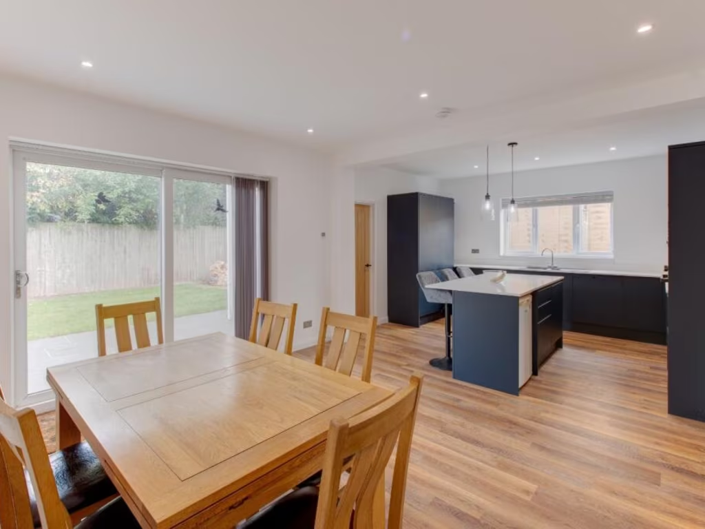
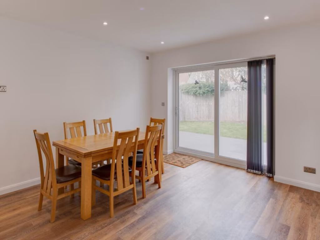
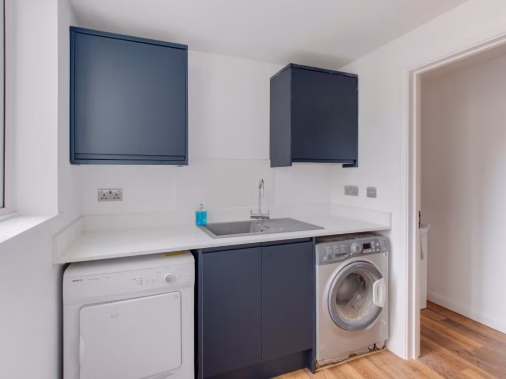
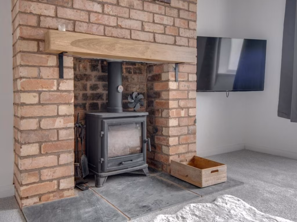
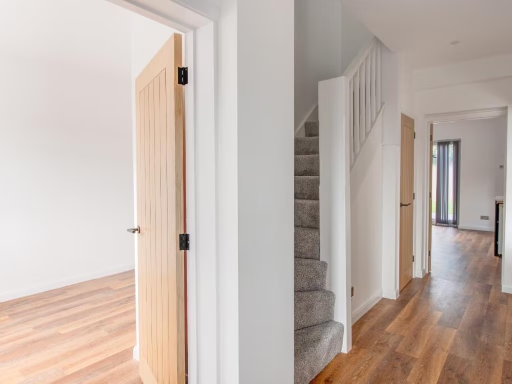
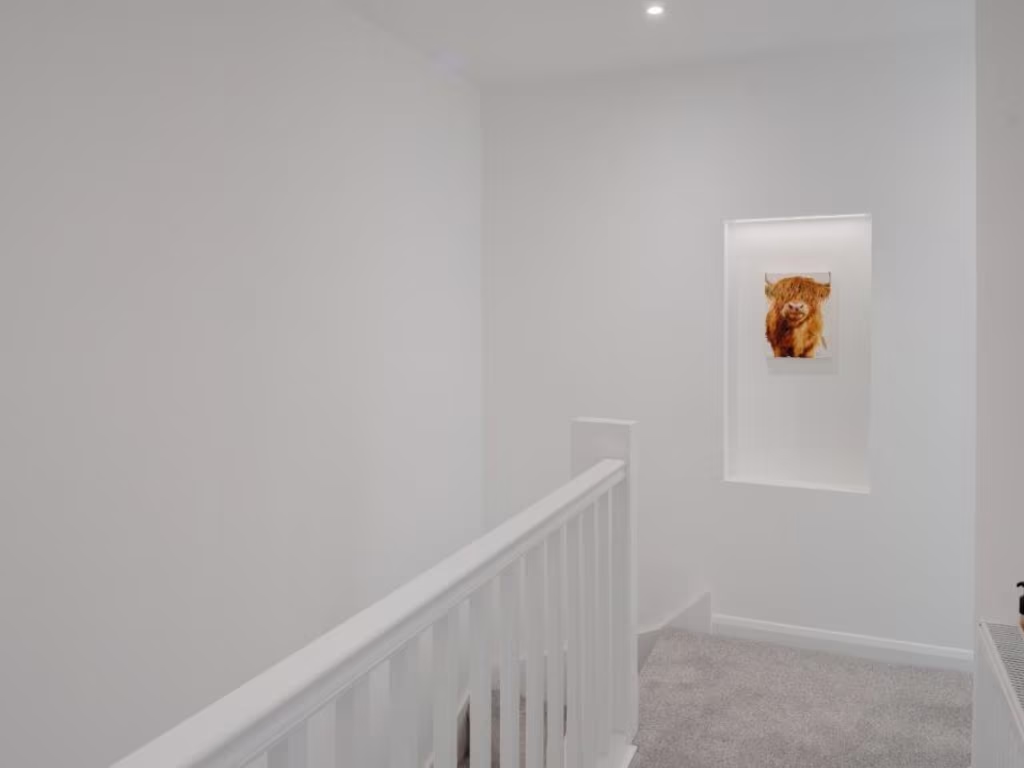
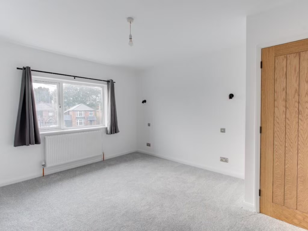
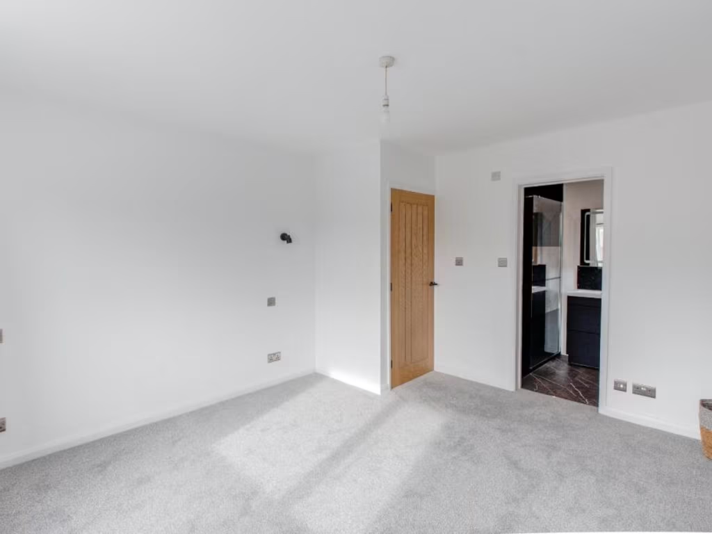
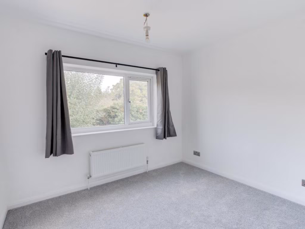
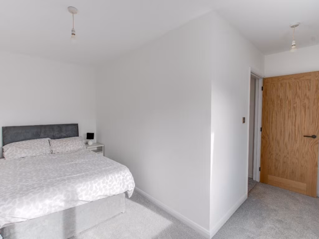
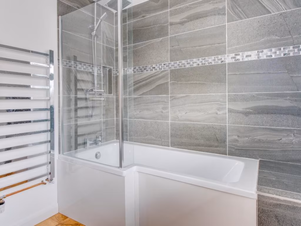
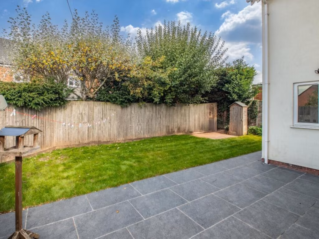
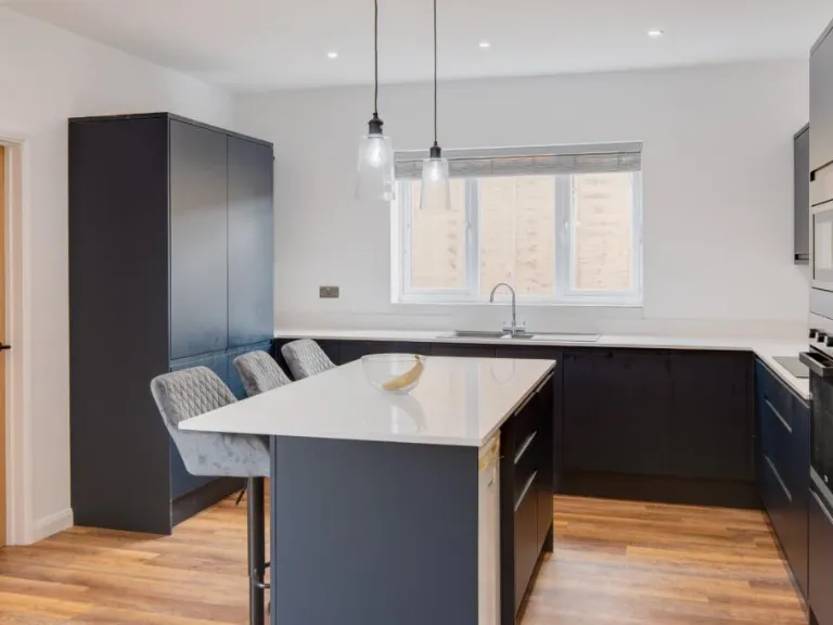
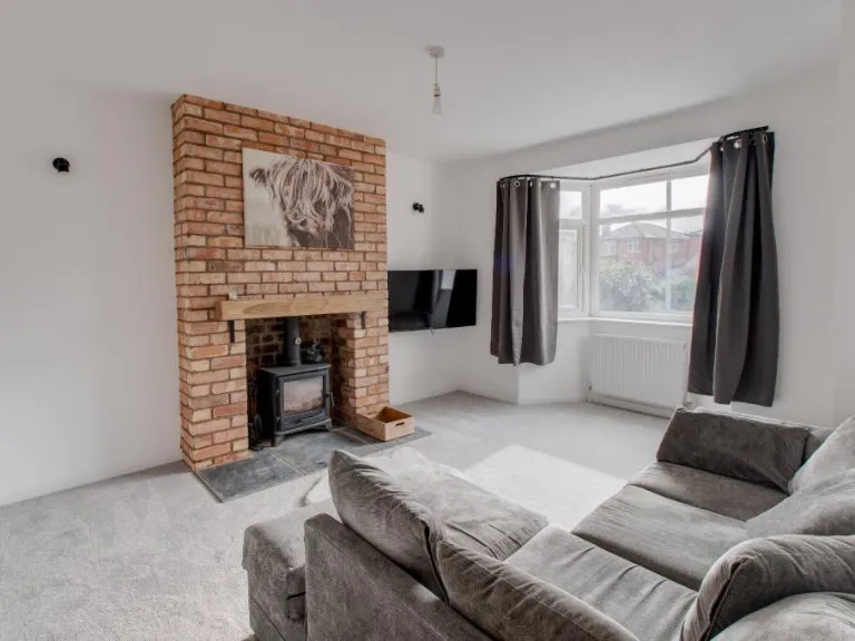
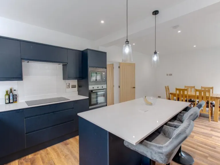
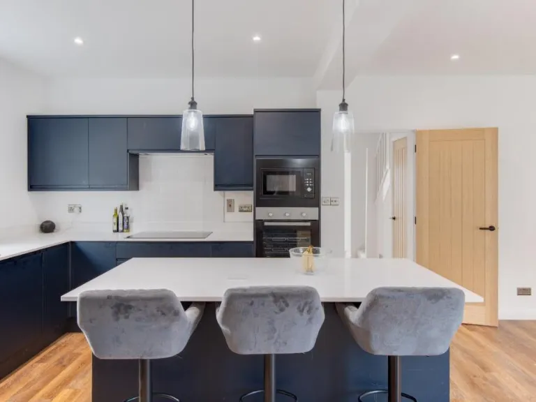
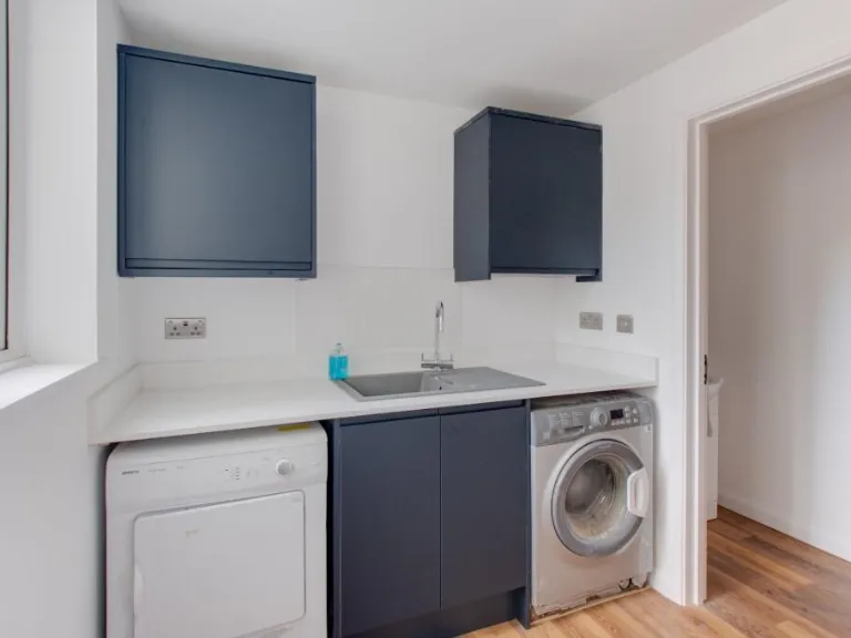
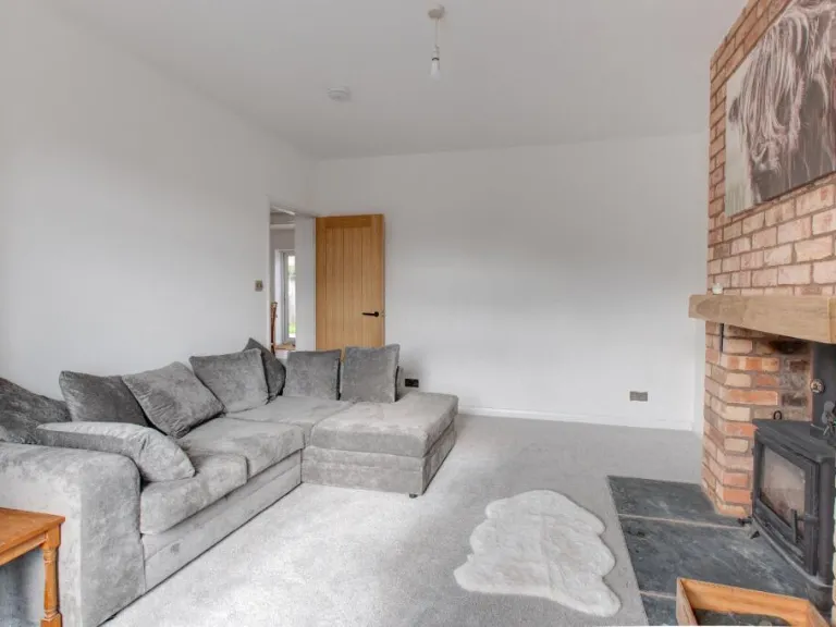
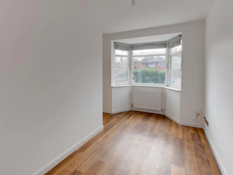
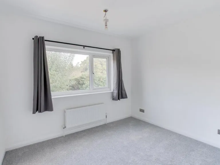
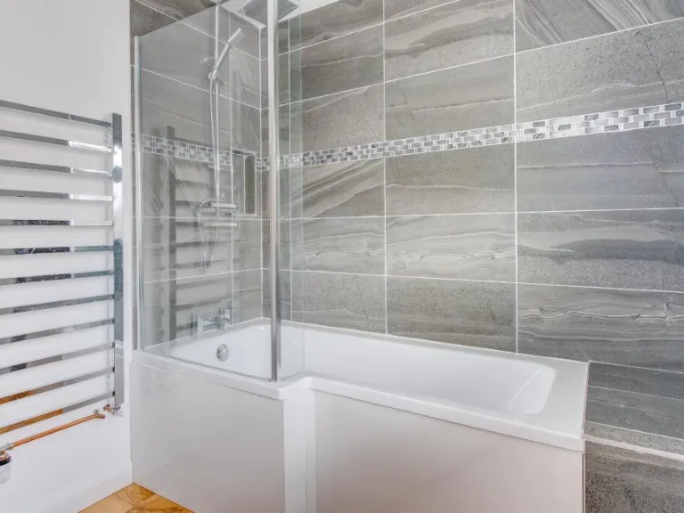
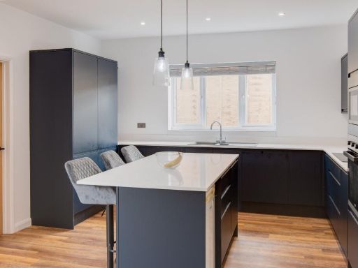
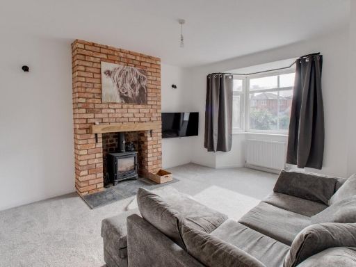
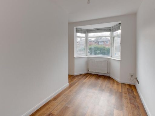
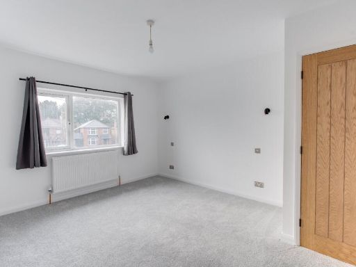
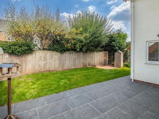
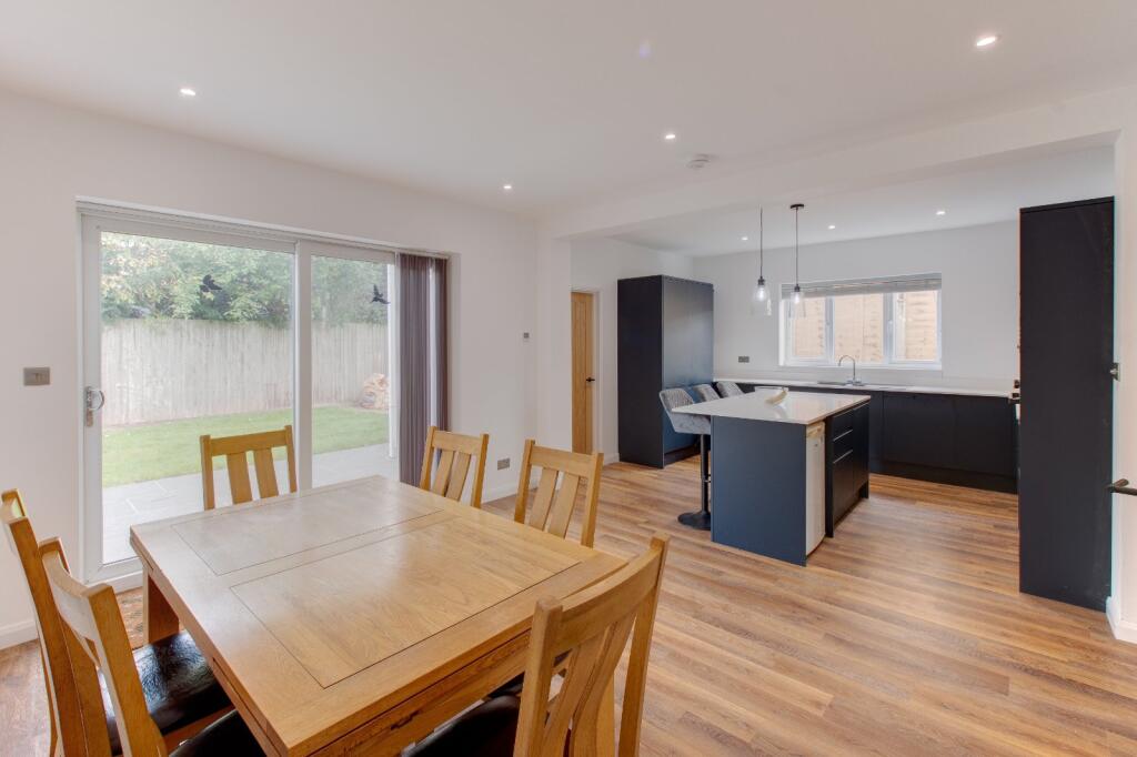
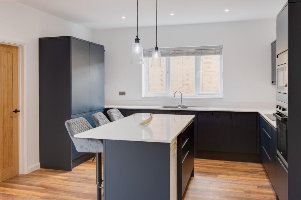
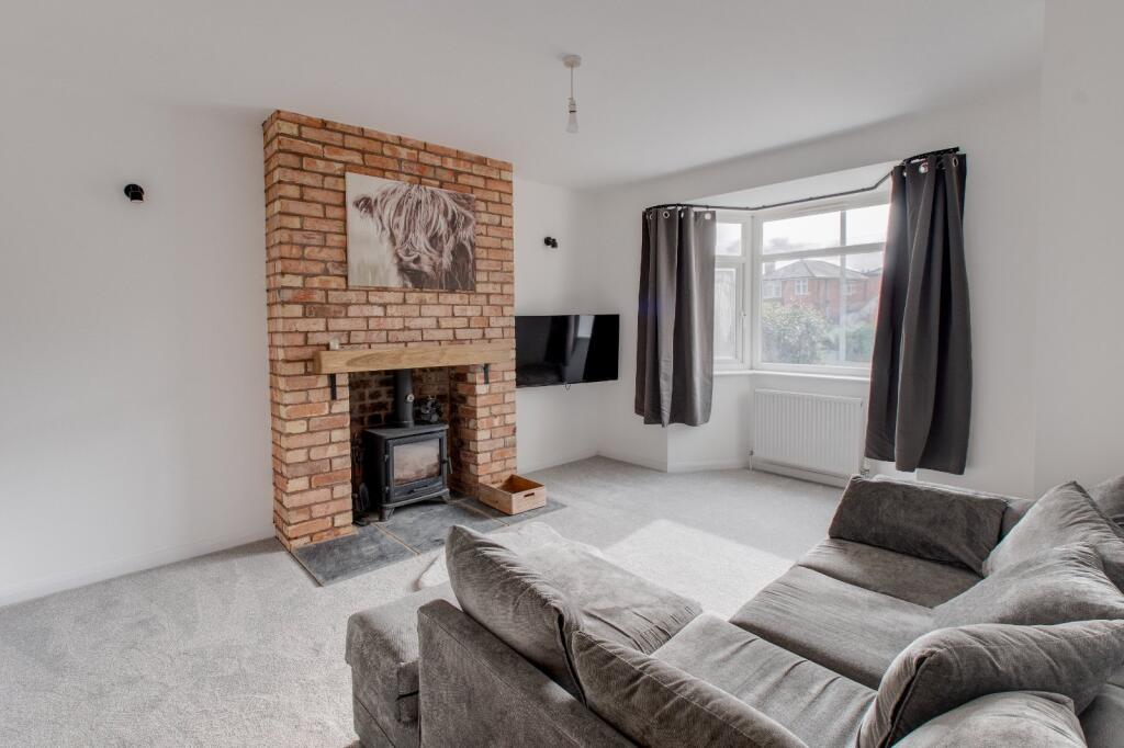
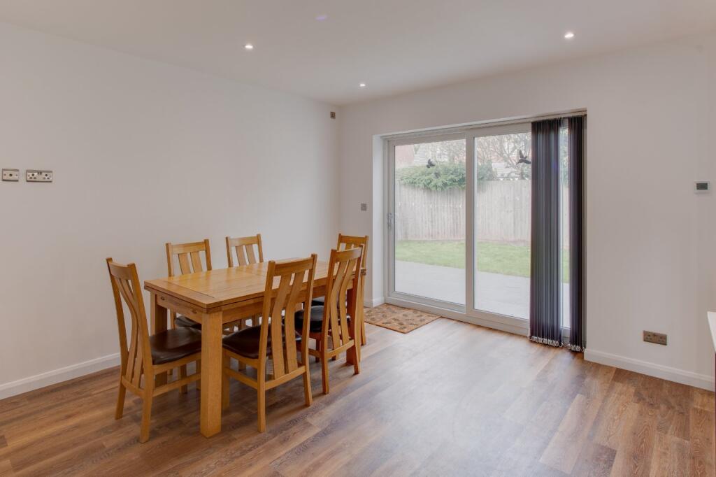
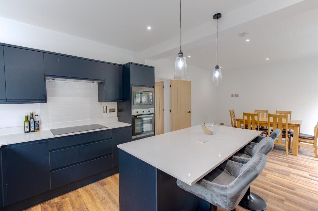
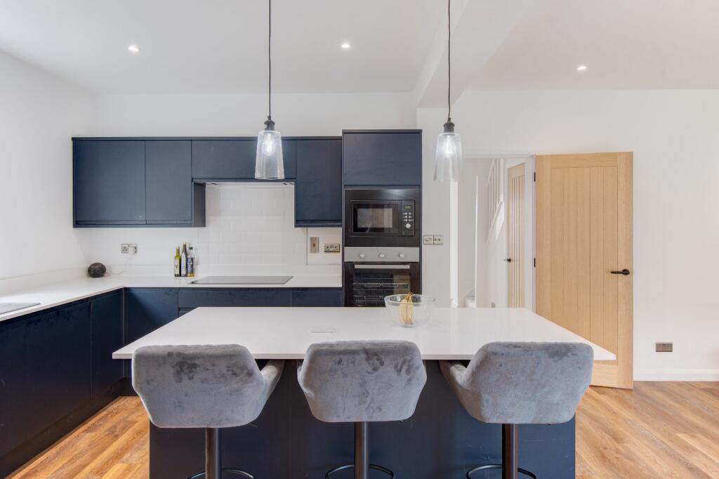
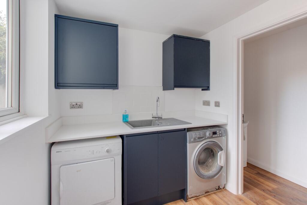
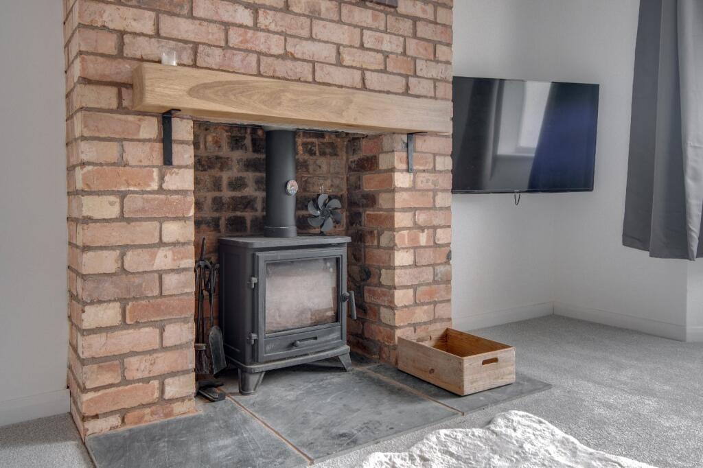
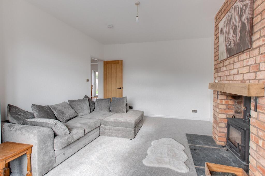
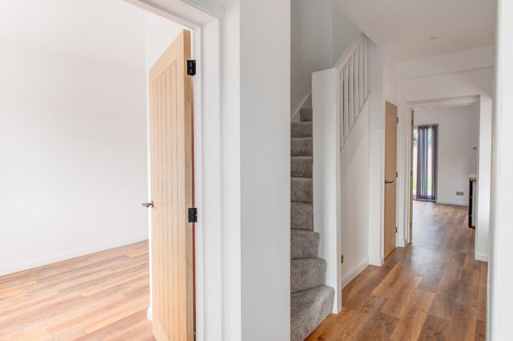
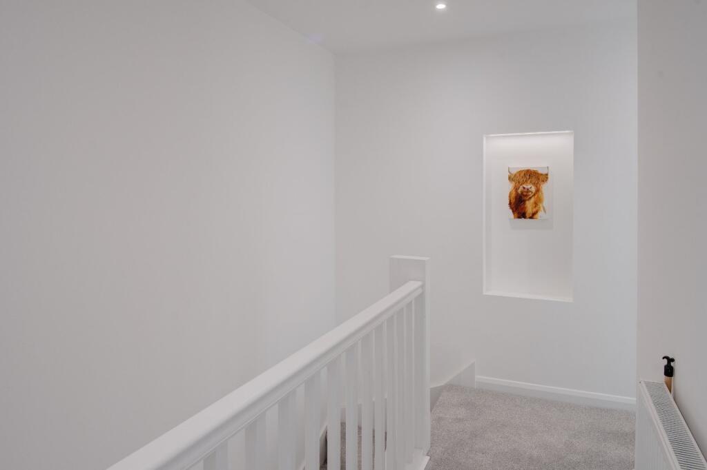
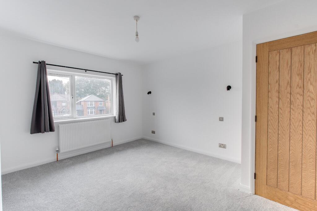
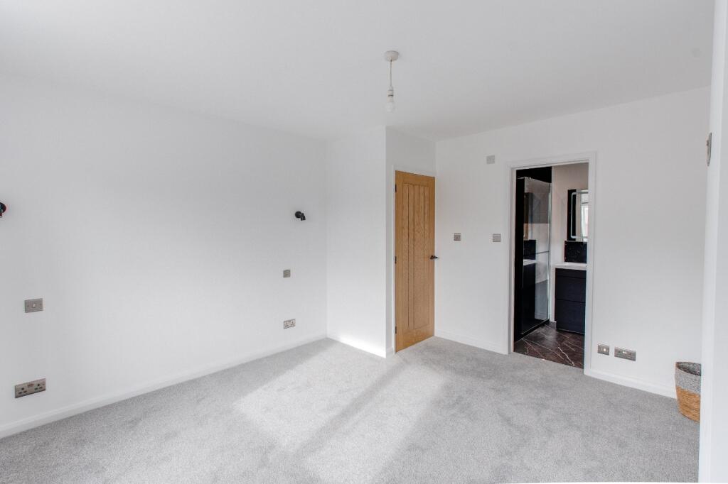
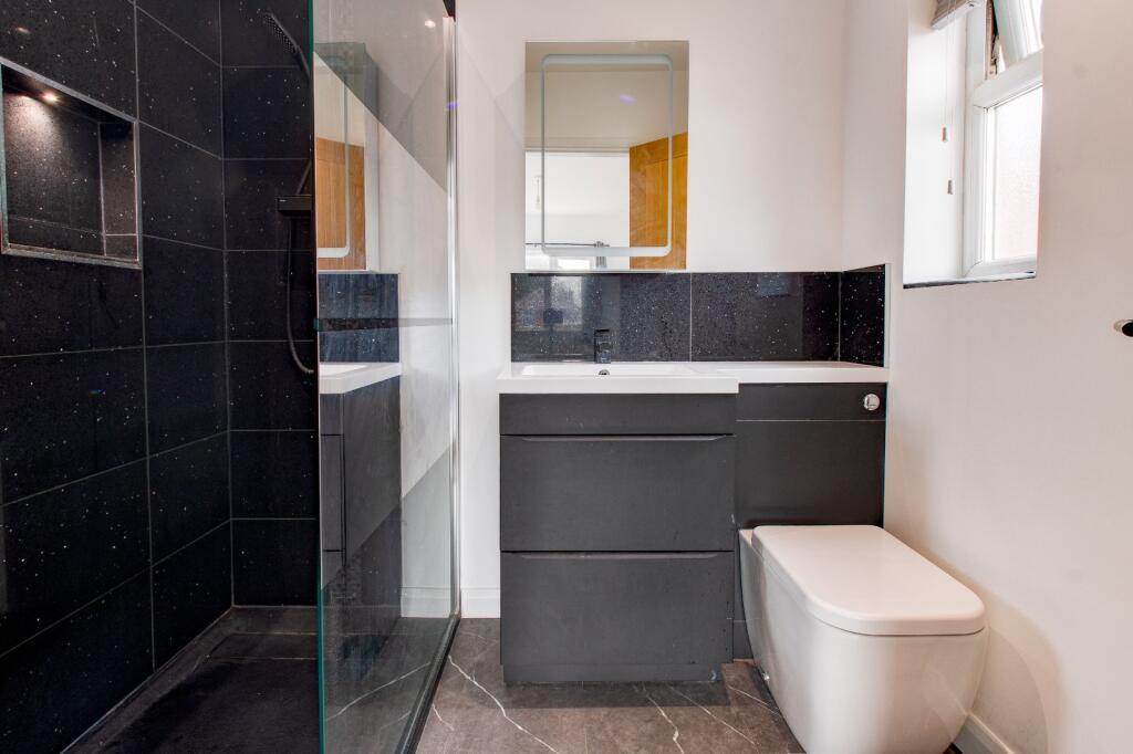
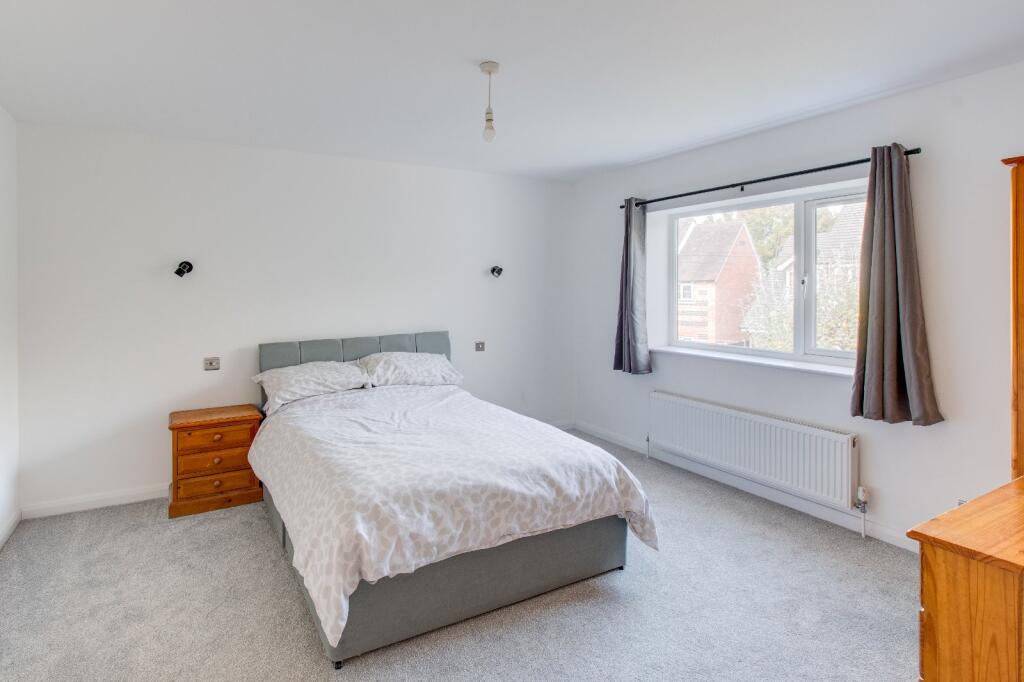
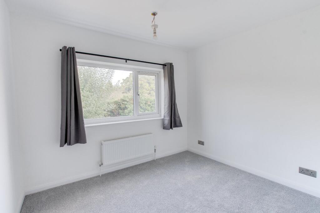
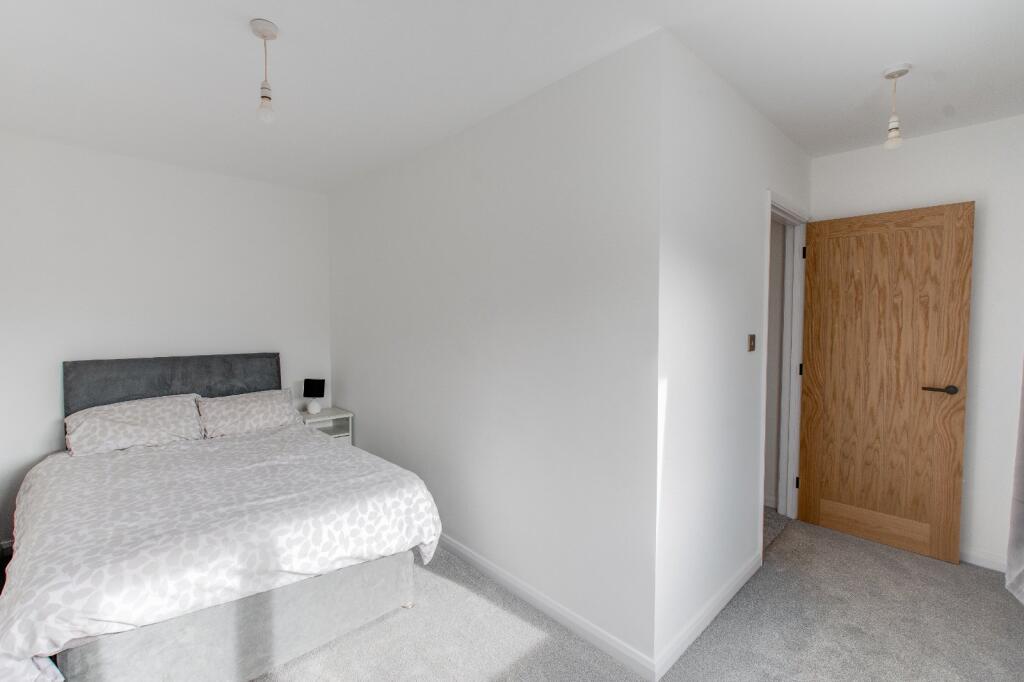
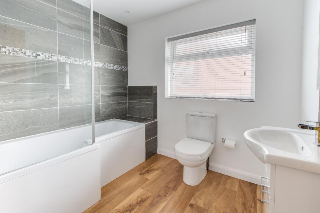
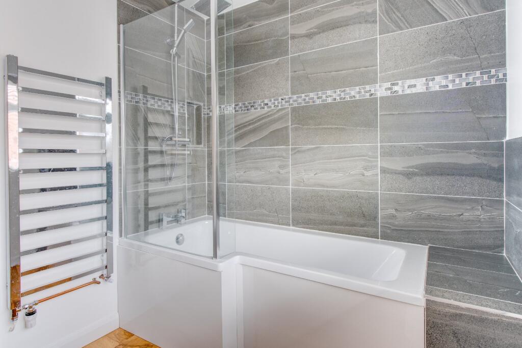
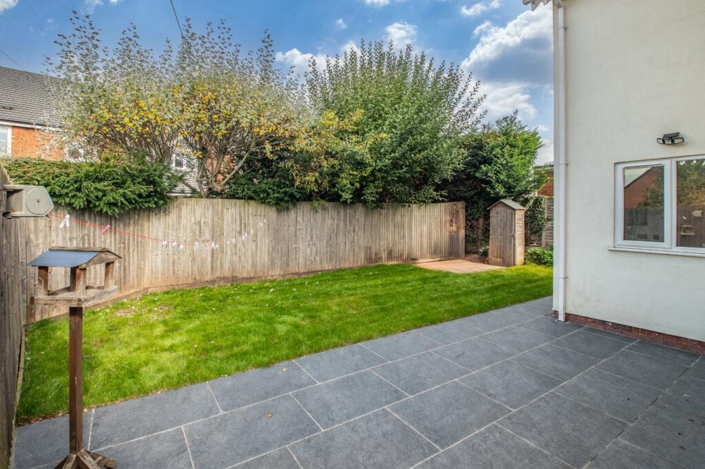
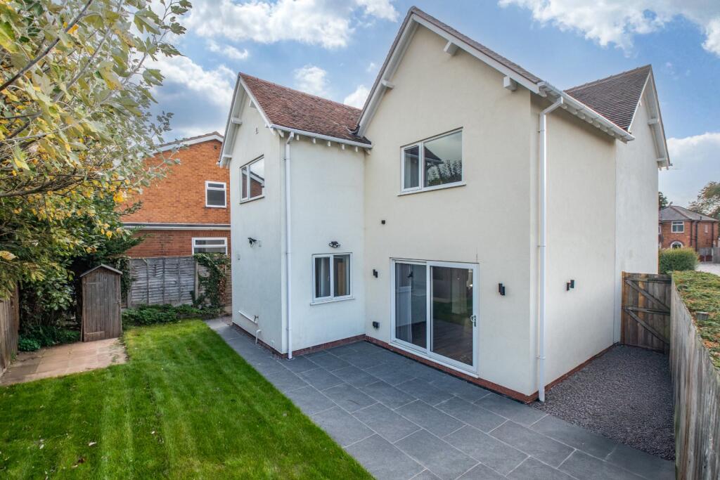
- Detached, double-fronted family home occupying a prominent plot in Aston Fields, Bromsgrove. The property has been extensively refurbished and extended to create a modern, energy-efficient residence with generous living accommodation. Key features visible and described: four bedrooms (master with en-suite), an impressive open-plan kitchen/dining/living area with a central island and integrated appliances, a separate utility and downstairs WC, a bay-fronted lounge with a log burner set into an exposed brick surround, and a bright home office space off the hallway. The dining area opens directly onto the rear garden via sliding doors. Externally there is a large block-paved driveway providing parking for several vehicles and gated side access to a private rear garden with paved patio and lawn – a peaceful, family-friendly outdoor space. Room proportions appear generous in the reception and kitchen/dining spaces; bedrooms are well-sized (average to large for a family home). Overall the property presents as a spacious, modern family house in good decorative order with practical storage and contemporary fittings throughout.
Image Descriptions
- residential house post-war
- dining and kitchen area contemporary
Floorplan Description
- Two-storey residential property with lounge, dining area, kitchen, utility and four bedrooms
Rooms
- Dining Area:
- Kitchen:
- Utility:
- WC:
- Office:
- Entrance Hall:
- Lounge:
- Bedroom 3:
- Bedroom 2:
- Bathroom:
- En-suite:
- Bedroom 1:
- Bedroom 4:
- Landing:
Textual Property Features
Detected Visual Features
- post-war
- detached
- solar panels
- brickwork
- bay window
- driveway
- chimney
- contemporary style
- open-plan
- kitchen island
- wood flooring
- sliding doors
- natural light
EPC Details
- Mostly double glazing
- Cavity wall, filled cavity
- Boiler and radiators, mains gas
- Low energy lighting in 52% of fixed outlets
- Solid, no insulation (assumed)
Nearby Schools
- St Andrew's CofE First School
- Hanbury CofE First School
- St Peter's Catholic First School
- Aston Fields Middle School
- Parkside Middle School
- Meadows First School
- Dodford First School
- Millfields First School
- Bromsgrove School
- Finstall First School
- St John's Church of England Middle School Academy
- Lickey End First School
- Lickey Hills Primary School and Nursery
- Beaconside Primary and Nursery School
- Waseley Hills High School
- North Bromsgrove High School
- The Orchards School
- Fairfield First School
- Wychbold First and Nursery School
- Stoke Prior First School
- Tardebigge CofE First School
- South Bromsgrove High
Nearest Bars And Restaurants
- Id: 3504165810
- Tags:
- Amenity: fast_food
- Name: Zinga
- TagsNormalized:
- Lat: 52.323009
- Lon: -2.0484774
- FullGeoHash: gcq99mh7e5bd
- PartitionGeoHash: gcq9
- Images:
- FoodStandards: null
- Distance: 590.6
,- Id: 8549592703
- Tags:
- Addr:
- City: Bromsgrove
- Housenumber: 3
- Postcode: B60 3EQ
- Street: Stoke Road
- Amenity: restaurant
- Name: No3a social
- Phone: +44 1527 874139
- Website: www.no3a.co.uk
- TagsNormalized:
- Lat: 52.3230079
- Lon: -2.048632
- FullGeoHash: gcq99mh5x7t7
- PartitionGeoHash: gcq9
- Images:
- FoodStandards: null
- Distance: 580.1
,- Id: 3504165774
- Tags:
- Amenity: fast_food
- Cuisine: chinese
- Name: Aston House Chinese Take-away
- TagsNormalized:
- Lat: 52.3228166
- Lon: -2.049521
- FullGeoHash: gcq99m5d6xyq
- PartitionGeoHash: gcq9
- Images:
- FoodStandards: null
- Distance: 521.1
,- Id: 579358224
- Tags:
- Amenity: pub
- Building: yes
- Name: Aston Fields Social Club
- Source: bing
- TagsNormalized:
- Lat: 52.322867
- Lon: -2.0536939
- FullGeoHash: gcq99m0dc3qg
- PartitionGeoHash: gcq9
- Images:
- FoodStandards: null
- Distance: 238.7
,- Id: 372317204
- Tags:
- Addr:
- City: Bromsgrove
- Street: Charford Road
- Alt_name: Kentucky Fried Chicken
- Amenity: fast_food
- Brand: KFC
- Brand:wikidata: Q524757
- Brand:wikipedia: en:KFC
- Building: retail
- Contact:
- Website: https://www.kfc.co.uk/kfc-near-me/bromsgrove-charford-road
- Cuisine: chicken
- Drive_through: yes
- Name: KFC
- Opening_hours: Mo-Su 10:30-23:00
- Outdoor_seating: yes
- Smoking: no
- Takeaway: yes
- Wheelchair: yes
- TagsNormalized:
- fast food
- food
- kfc
- retail
- chicken
- drive through
- takeaway
- Lat: 52.3226471
- Lon: -2.0598567
- FullGeoHash: gcq99jh19b7e
- PartitionGeoHash: gcq9
- Images:
- FoodStandards: null
- Distance: 193.4
}
Nearest General Shops
- Id: 54611544
- Tags:
- Building: yes
- Name: Bromsgrove Tyres & Exhausts
- Shop: tyres
- TagsNormalized:
- Lat: 52.3215311
- Lon: -2.0571661
- FullGeoHash: gcq99hy5083f
- PartitionGeoHash: gcq9
- Images:
- FoodStandards: null
- Distance: 186.3
,- Id: 343578270
- Tags:
- Brand: Pets at Home
- Brand:wikidata: Q7179258
- Brand:wikipedia: en:Pets at Home
- Building: yes
- Name: Pets at Home
- Shop: pet
- Wheelchair: yes
- TagsNormalized:
- Lat: 52.3217318
- Lon: -2.0584272
- FullGeoHash: gcq99hvh5jtr
- PartitionGeoHash: gcq9
- Images:
- FoodStandards: null
- Distance: 185.1
,- Id: 343578246
- Tags:
- Brand: Homebase
- Brand:wikidata: Q9293447
- Brand:wikipedia: en:Homebase
- Building: yes
- Contact:
- Website: https://store.homebase.co.uk/bromsgrove/brook-retail-park
- Name: Homebase
- Shop: doityourself
- Wheelchair: yes
- TagsNormalized:
- Lat: 52.3217649
- Lon: -2.0579757
- FullGeoHash: gcq99hvkmeyh
- PartitionGeoHash: gcq9
- Images:
- FoodStandards: null
- Distance: 169.6
}
Nearest Grocery shops
- Id: 3505203234
- Tags:
- Addr:
- City: Bromsgrove
- Housenumber: 176-180
- Postcode: B61 7AZ
- Street: Worcester Road
- Brand: One Stop
- Brand:wikidata: Q65954217
- Fhrs:
- Name: One Stop
- Shop: convenience
- TagsNormalized:
- Lat: 52.3279782
- Lon: -2.0697211
- FullGeoHash: gcq98yhbs40h
- PartitionGeoHash: gcq9
- Images:
- FoodStandards:
- Id: 684460
- FHRSID: 684460
- LocalAuthorityBusinessID: BD/PI/000016873
- BusinessName: One Stop
- BusinessType: Retailers - other
- BusinessTypeID: 4613
- AddressLine1: 176-180 Worcester Road
- AddressLine2: Bromsgrove
- AddressLine3: Worcestershire
- AddressLine4: null
- PostCode: B61 7AZ
- RatingValue: 5
- RatingKey: fhrs_5_en-GB
- RatingDate: 2021-09-01
- LocalAuthorityCode: 145
- LocalAuthorityName: Bromsgrove
- LocalAuthorityWebSite: https://www.worcsregservices.gov.uk
- LocalAuthorityEmailAddress: enquiries@worcsregservices.gov.uk
- Scores:
- Hygiene: 5
- Structural: 5
- ConfidenceInManagement: 5
- NewRatingPending: false
- Geocode:
- Longitude: -2.07028400000000
- Latitude: 52.32761300000000
- Distance: 1005
,- Id: 690262547
- Tags:
- TagsNormalized:
- Lat: 52.3225626
- Lon: -2.0665451
- FullGeoHash: gcq98vp1n087
- PartitionGeoHash: gcq9
- Images:
- FoodStandards: null
- Distance: 641.7
,- Id: 595349073
- Tags:
- Name: The Co-operative
- Shop: convenience
- TagsNormalized:
- Lat: 52.3229941
- Lon: -2.0483642
- FullGeoHash: gcq99mh7t9hc
- PartitionGeoHash: gcq9
- Images:
- FoodStandards: null
- Distance: 598.4
}
Nearest Supermarkets
- Id: 538373522
- Tags:
- Addr:
- Postcode: B61 8RR
- Street: St John Street
- Brand: Waitrose
- Brand:wikidata: Q771734
- Brand:wikipedia: en:Waitrose
- Building: supermarket
- Name: Waitrose
- Official_name: Waitrose & Partners
- Opening_hours: Mo-Sa 07:00-22:00; Su 11:00-17:00
- Operator: Waitrose & Partners
- Phone: +44 1527 876189
- Shop: supermarket
- Website: https://www.waitrose.com/bf_home/bf/877.html
- Wheelchair: yes
- TagsNormalized:
- Lat: 52.3330706
- Lon: -2.0644403
- FullGeoHash: gcq99nbwpp3w
- PartitionGeoHash: gcq9
- Images:
- FoodStandards: null
- Distance: 1203.2
,- Id: 54510516
- Tags:
- Addr:
- City: Bromsgrove
- Country: GB
- Postcode: B60 3EX
- Street: Buntsford Park Road
- Brand: Morrisons
- Brand:wikidata: Q922344
- Brand:wikipedia: en:Morrisons
- Building: yes
- Contact:
- Website: https://my.morrisons.com/storefinder/242
- Name: Morrisons
- Shop: supermarket
- TagsNormalized:
- Lat: 52.3170946
- Lon: -2.0652969
- FullGeoHash: gcq99h015j71
- PartitionGeoHash: gcq9
- Images:
- FoodStandards: null
- Distance: 876.1
,- Id: 54513845
- Tags:
- Brand: ALDI
- Brand:wikidata: Q41171672
- Brand:wikipedia: en:Aldi
- Building: yes
- Contact:
- Website: https://stores.aldi.co.uk/bromsgrove/sherwood-road
- Name: ALDI
- Shop: supermarket
- TagsNormalized:
- Lat: 52.3183427
- Lon: -2.0625542
- FullGeoHash: gcq99h607jbn
- PartitionGeoHash: gcq9
- Images:
- FoodStandards: null
- Distance: 653.3
}
Nearest Religious buildings
- Id: 54510513
- Tags:
- Amenity: place_of_worship
- Building: yes
- Denomination: catholic
- Name: St Peter's Catholic Church
- Name:la: Ecclesia Sancti Petri
- Religion: christian
- TagsNormalized:
- place of worship
- catholic
- church
- christian
- Lat: 52.3266137
- Lon: -2.0706458
- FullGeoHash: gcq98vu0w7y9
- PartitionGeoHash: gcq9
- Images:
- FoodStandards: null
- Distance: 991.6
,- Id: 54510923
- Tags:
- Amenity: place_of_worship
- Building: church
- Denomination: anglican
- Name: St Andrew
- Religion: christian
- Wikidata: Q105105252
- TagsNormalized:
- place of worship
- church
- anglican
- christian
- Lat: 52.3226528
- Lon: -2.0694801
- FullGeoHash: gcq98vj1997v
- PartitionGeoHash: gcq9
- Images:
- FoodStandards: null
- Distance: 839.5
,- Id: 343728259
- Tags:
- Amenity: place_of_worship
- Building: yes
- Denomination: anglican
- Name: St Godwald
- Religion: christian
- Source: visual survey;bing
- Wikidata: Q26639393
- TagsNormalized:
- place of worship
- anglican
- christian
- church
- Lat: 52.3243124
- Lon: -2.0463064
- FullGeoHash: gcq99mmgjwg3
- PartitionGeoHash: gcq9
- Images:
- FoodStandards: null
- Distance: 747.9
}
Nearest Medical buildings
- Id: 3505188793
- Tags:
- Addr:
- City: Bromsgrove
- Housenumber: 58-60
- Postcode: B61 8EX
- Street: High Street
- Amenity: pharmacy
- Brand: Superdrug
- Brand:wikidata: Q7643261
- Brand:wikipedia: en:Superdrug
- Drive_through: no
- Healthcare: pharmacy
- Name: Superdrug
- Opening_hours: Mo-Sa 09:00-17:30; Su 10:00-16:00
- Phone: +44 1527 831 421
- Website: https://www.superdrug.com/store/bromsgrove
- TagsNormalized:
- pharmacy
- superdrug
- health
- healthcare
- Lat: 52.334634
- Lon: -2.0609311
- FullGeoHash: gcq99p5r2ffk
- PartitionGeoHash: gcq9
- Images:
- FoodStandards: null
- Distance: 1296.3
,- Id: 459375985
- Tags:
- Amenity: doctors
- Healthcare: doctor
- Name: New Road Surgery
- TagsNormalized:
- doctor
- doctors
- health
- healthcare
- surgery
- Lat: 52.3304554
- Lon: -2.0556672
- FullGeoHash: gcq99nrngrzm
- PartitionGeoHash: gcq9
- Images:
- FoodStandards: null
- Distance: 812.4
,- Id: 459375471
- Tags:
- Amenity: pharmacy
- Healthcare: pharmacy
- TagsNormalized:
- Lat: 52.3303014
- Lon: -2.0554414
- FullGeoHash: gcq99nrq0epz
- PartitionGeoHash: gcq9
- Images:
- FoodStandards: null
- Distance: 797.6
,- Id: 3504165785
- Tags:
- Amenity: dentist
- Healthcare: dentist
- Name: Dental Surgery
- TagsNormalized:
- dentist
- health
- healthcare
- dental
- surgery
- Lat: 52.3228299
- Lon: -2.0494282
- FullGeoHash: gcq99m5dsf7t
- PartitionGeoHash: gcq9
- Images:
- FoodStandards: null
- Distance: 527.2
}
Nearest Airports
- Id: 2437117
- Tags:
- Aerodrome: international
- Aerodrome:type: public
- Aeroway: aerodrome
- Ele: 104
- Iata: BHX
- Icao: EGBB
- Internet_access: wlan
- Is_in: Birmingham,England,UK
- Name: Birmingham Airport
- Ref: BHX
- Type: multipolygon
- Website: https://www.birminghamairport.co.uk/
- Wikidata: Q8719
- Wikipedia: en:Birmingham Airport
- TagsNormalized:
- airport
- international airport
- Lat: 52.4543817
- Lon: -1.7468974
- FullGeoHash: gcqf2jpbym6y
- PartitionGeoHash: gcqf
- Images:
- FoodStandards: null
- Distance: 25613.9
}
Nearest Leisure Facilities
- Id: 3504165808
- Tags:
- Leisure: sports_centre
- Name: Verve Martial Arts
- Sport: martial_arts
- TagsNormalized:
- sports
- sports centre
- leisure
- martial
- martial arts
- Lat: 52.3207315
- Lon: -2.0586681
- FullGeoHash: gcq99hsyme3b
- PartitionGeoHash: gcq9
- Images:
- FoodStandards: null
- Distance: 293.6
,- Id: 3504165797
- Tags:
- Leisure: swimming_pool
- Name: Making Waves Swimming Pool
- TagsNormalized:
- swimming
- swimming pool
- pool
- leisure
- Lat: 52.3207905
- Lon: -2.0583606
- FullGeoHash: gcq99htnswr0
- PartitionGeoHash: gcq9
- Images:
- FoodStandards: null
- Distance: 280.7
,- Id: 897470572
- Tags:
- Leisure: playground
- Source: bing
- TagsNormalized:
- Lat: 52.323472
- Lon: -2.0532907
- FullGeoHash: gcq99m0y6f5k
- PartitionGeoHash: gcq9
- Images:
- FoodStandards: null
- Distance: 264.7
,- Id: 3504165794
- Tags:
- Leisure: fitness_centre
- Name: Lifeline Fitness
- TagsNormalized:
- fitness
- fitness centre
- leisure
- Lat: 52.3208987
- Lon: -2.0579368
- FullGeoHash: gcq99htrqd7j
- PartitionGeoHash: gcq9
- Images:
- FoodStandards: null
- Distance: 261.9
,- Id: 54611546
- Tags:
- Building: yes
- Leisure: fitness_centre
- Name: Lowcost Gyms
- TagsNormalized:
- fitness
- fitness centre
- leisure
- Lat: 52.3213656
- Lon: -2.0570318
- FullGeoHash: gcq99hy459my
- PartitionGeoHash: gcq9
- Images:
- FoodStandards: null
- Distance: 204.9
}
Nearest Tourist attractions
- Id: 260766093
- Tags:
- Access: private
- Addr:
- City: Bromsgrove
- Postcode: B60 1PX
- Street: Agmore Road
- Description: Outdoor activity centre, camp site, indoor accommodation. Available for Schools, Youth Organisations (Scouts), company activities and birthday parties.
- Fee: yes
- Internet_access: yes
- Name: Blackwell Adventure Outdoor Activity Centre
- Operator: Blackwell Adventure
- Phone: +44 121 4451285
- Tourism: camp_site
- Website: http://www.blackwelladventure.co.uk
- TagsNormalized:
- Lat: 52.3430713
- Lon: -2.012916
- FullGeoHash: gcq9f0y0rxtn
- PartitionGeoHash: gcq9
- Images:
- FoodStandards: null
- Distance: 3730.6
,- Id: 38741056
- Tags:
- Addr:
- Name: Avoncroft Museum of Buildings
- Tourism: museum
- Website: https://www.avoncroft.org.uk/
- Wikidata: Q4829273
- Wikipedia: en:Avoncroft Museum of Historic Buildings
- TagsNormalized:
- Lat: 52.3135331
- Lon: -2.0718781
- FullGeoHash: gcq98g7k3trs
- PartitionGeoHash: gcq9
- Images:
- FoodStandards: null
- Distance: 1468.8
,- Id: 121521900
- Tags:
- Source: visual survey;bing
- Tourism: picnic_site
- TagsNormalized:
- Lat: 52.314314
- Lon: -2.0697336
- FullGeoHash: gcq98gsbgwyy
- PartitionGeoHash: gcq9
- Images:
- FoodStandards: null
- Distance: 1306.9
}
Nearest Train stations
- Id: 21227482
- Tags:
- Name: Droitwich Spa
- Naptan:
- Network: National Rail
- Operator: London Midland
- Platforms: 2
- Public_transport: station
- Railway: station
- Ref:
- Train: yes
- Wikidata: Q2360854
- Wikipedia: en:Droitwich Spa railway station
- TagsNormalized:
- Lat: 52.2683805
- Lon: -2.1583391
- FullGeoHash: gcq3qghm7h3d
- PartitionGeoHash: gcq3
- Images:
- FoodStandards: null
- Distance: 9192.8
,- Id: 335714346
- Tags:
- Name: Redditch
- Naptan:
- Network: National Rail
- Public_transport: station
- Railway: station
- Ref:
- Wheelchair: yes
- Wikidata: Q2253146
- Wikipedia: en:Redditch railway station
- TagsNormalized:
- Lat: 52.3063807
- Lon: -1.9456089
- FullGeoHash: gcq9edp6b00f
- PartitionGeoHash: gcq9
- Images:
- FoodStandards: null
- Distance: 7810.3
,- Id: 9290941286
- Tags:
- Name: Alvechurch
- Naptan:
- Network: National Rail
- Public_transport: station
- Railway: station
- Ref:
- Source: NPE
- Wikidata: Q4355883
- Wikipedia: en:Alvechurch railway station
- TagsNormalized:
- Lat: 52.3468339
- Lon: -1.9679877
- FullGeoHash: gcq9g1qyqt45
- PartitionGeoHash: gcq9
- Images:
- FoodStandards: null
- Distance: 6604
,- Id: 21227431
- Tags:
- Name: Barnt Green
- Naptan:
- Network: National Rail
- Public_transport: station
- Railway: station
- Ref:
- Source: NPE
- Wikidata: Q2658226
- Wikipedia: en:Barnt Green railway station
- TagsNormalized:
- Lat: 52.3609702
- Lon: -1.9924997
- FullGeoHash: gcq9fsj0g2k9
- PartitionGeoHash: gcq9
- Images:
- FoodStandards: null
- Distance: 6076.9
,- Id: 1523190627
- Tags:
- Name: Bromsgrove
- Naptan:
- Network: National Rail
- Public_transport: station
- Railway: station
- Ref:
- Source: NPE
- Wikidata: Q1978141
- Wikipedia: en:Bromsgrove railway station
- TagsNormalized:
- Lat: 52.3201581
- Lon: -2.0499793
- FullGeoHash: gcq99ke7002e
- PartitionGeoHash: gcq9
- Images:
- FoodStandards: null
- Distance: 594.3
}
Nearest Hotels
- Id: 54869292
- Tags:
- Brand: Premier Inn
- Brand:wikidata: Q2108626
- Brand:wikipedia: en:Premier Inn
- Building: yes
- Internet_access: wlan
- Internet_access:fee: customers
- Internet_access:operator: Virgin Media
- Internet_access:ssid: Premier Inn Free Wi-Fi
- Name: Premier Inn
- Source: bing;survey
- Tourism: hotel
- TagsNormalized:
- Lat: 52.33887
- Lon: -2.0490362
- FullGeoHash: gcq9c25bjbxb
- PartitionGeoHash: gcq9
- Images:
- FoodStandards: null
- Distance: 1827.1
,- Id: 443655057
- Tags:
- Addr:
- City: Bromsgrove
- Country: GB
- Housenumber: 20
- Postcode: B61 8HH
- Street: High Street
- Amenity: pub
- Brand: Wetherspoon
- Brand:wikidata: Q6109362
- Brand:wikipedia: en:Wetherspoons
- Contact:
- Website: https://www.jdwetherspoon.com/pubs/all-pubs/england/worcestershire/golden-cross-hotel-bromsgrove
- Fhrs:
- Food: yes
- Name: Golden Cross Hotel
- Phone: +44 1527 870005
- Real_ale: yes
- TagsNormalized:
- Lat: 52.3339155
- Lon: -2.0617546
- FullGeoHash: gcq99p4ejsuq
- PartitionGeoHash: gcq9
- Images:
- FoodStandards: null
- Distance: 1231
,- Id: 138945537
- Tags:
- Addr:
- City: Bromsgrove
- Housenumber: 2
- Postcode: B60 2DZ
- Street: Finstall Road
- Suburb: Aston Fields
- Air_conditioning: no
- Brand: Ibis Budget
- Brand:wikidata: Q1458135
- Brand:wikipedia: en:Ibis Budget
- Building: yes
- Email: hb8f1@accor.com
- Internet_access: wlan
- Internet_access:fee: no
- Internet_access:ssid: Travelodge WiFi
- Name: ibis budget Bromsgrove 2 stars
- Pets_allowed: yes
- Phone: +44 1527 919396
- Rooms: 43
- Smoking: no
- Stars: 2
- Tourism: hotel
- Website: https://all.accor.com/hotel/B8F1/index.en.shtml
- Wheelchair: yes
- TagsNormalized:
- Lat: 52.3226702
- Lon: -2.0477546
- FullGeoHash: gcq99mhceuet
- PartitionGeoHash: gcq9
- Images:
- FoodStandards: null
- Distance: 642.1
}
Tags
- post-war
- detached
- solar panels
- brickwork
- bay window
- driveway
- chimney
- contemporary style
- open-plan
- kitchen island
- wood flooring
- sliding doors
- natural light
Local Market Stats
- Average Price/sqft: £314
- Avg Income: £51500
- Rental Yield: 3.3%
- Social Housing: 4%
- Planning Success Rate: 83%
Similar Properties
 3 bedroom detached house for sale in Marlborough Avenue, Bromsgrove, Worcestershire, B60 — £495,000 • 3 bed • 1 bath • 1468 ft²
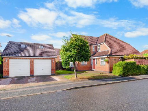 4 bedroom detached house for sale in Rutherford Road, Bromsgrove B60 3SA, B60 — £550,000 • 4 bed • 2 bath • 2007 ft²
 2 bedroom bungalow for sale in Brueton Avenue, Bromsgrove, Worcestershire, B60 — £315,000 • 2 bed • 1 bath • 969 ft²
 6 bedroom detached house for sale in Marlborough Avenue, Bromsgrove B60 2PG, B60 — £1,395,000 • 6 bed • 6 bath • 4433 ft²
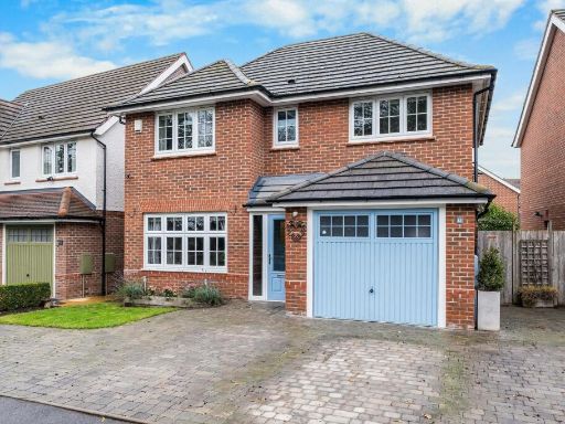 4 bedroom detached house for sale in Sidings Close, Bromsgrove B60 3SG, B60 — £525,000 • 4 bed • 2 bath • 1331 ft²
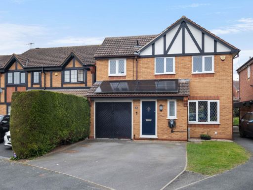 4 bedroom detached house for sale in Cirencester Close, Bromsgrove. B60 2RE, B60 — £450,000 • 4 bed • 2 bath • 1194 ft²
Meta
- {
"@context": "https://schema.org",
"@type": "Residence",
"name": "4 bedroom detached house for sale in Stoke Road, Bromsgrove…",
"description": "",
"url": "https://propertypiper.co.uk/property/719e1933-e217-4605-a42a-653a5bc230c0",
"image": "https://image-a.propertypiper.co.uk/a746bc47-3b6e-4f80-a300-d1a48bf739a5-1024.jpeg",
"address": {
"@type": "PostalAddress",
"streetAddress": "Stoke Road, Bromsgrove, Worcestershire, B60",
"postalCode": "B60 3ED",
"addressLocality": "Bromsgrove",
"addressRegion": "Bromsgrove",
"addressCountry": "England"
},
"geo": {
"@type": "GeoCoordinates",
"latitude": 52.32320627837558,
"longitude": -2.0571615489351105
},
"numberOfRooms": 4,
"numberOfBathroomsTotal": 2,
"floorSize": {
"@type": "QuantitativeValue",
"value": 1439,
"unitCode": "FTK"
},
"offers": {
"@type": "Offer",
"price": 585000,
"priceCurrency": "GBP",
"availability": "https://schema.org/InStock"
},
"additionalProperty": [
{
"@type": "PropertyValue",
"name": "Feature",
"value": "post-war"
},
{
"@type": "PropertyValue",
"name": "Feature",
"value": "detached"
},
{
"@type": "PropertyValue",
"name": "Feature",
"value": "solar panels"
},
{
"@type": "PropertyValue",
"name": "Feature",
"value": "brickwork"
},
{
"@type": "PropertyValue",
"name": "Feature",
"value": "bay window"
},
{
"@type": "PropertyValue",
"name": "Feature",
"value": "driveway"
},
{
"@type": "PropertyValue",
"name": "Feature",
"value": "chimney"
},
{
"@type": "PropertyValue",
"name": "Feature",
"value": "contemporary style"
},
{
"@type": "PropertyValue",
"name": "Feature",
"value": "open-plan"
},
{
"@type": "PropertyValue",
"name": "Feature",
"value": "kitchen island"
},
{
"@type": "PropertyValue",
"name": "Feature",
"value": "wood flooring"
},
{
"@type": "PropertyValue",
"name": "Feature",
"value": "sliding doors"
},
{
"@type": "PropertyValue",
"name": "Feature",
"value": "natural light"
}
]
}
High Res Floorplan Images
Compatible Floorplan Images
FloorplanImages Thumbnail