SO43 7GN - 3 bedroom detached house for sale in Ringwood Road, Stoney…
View on Property Piper
3 bedroom detached house for sale in Ringwood Road, Stoney Cross, Lyndhurst, SO43
Property Details
- Price: £1100000
- Bedrooms: 3
- Bathrooms: 3
- Property Type: undefined
- Property SubType: undefined
Brochure Descriptions
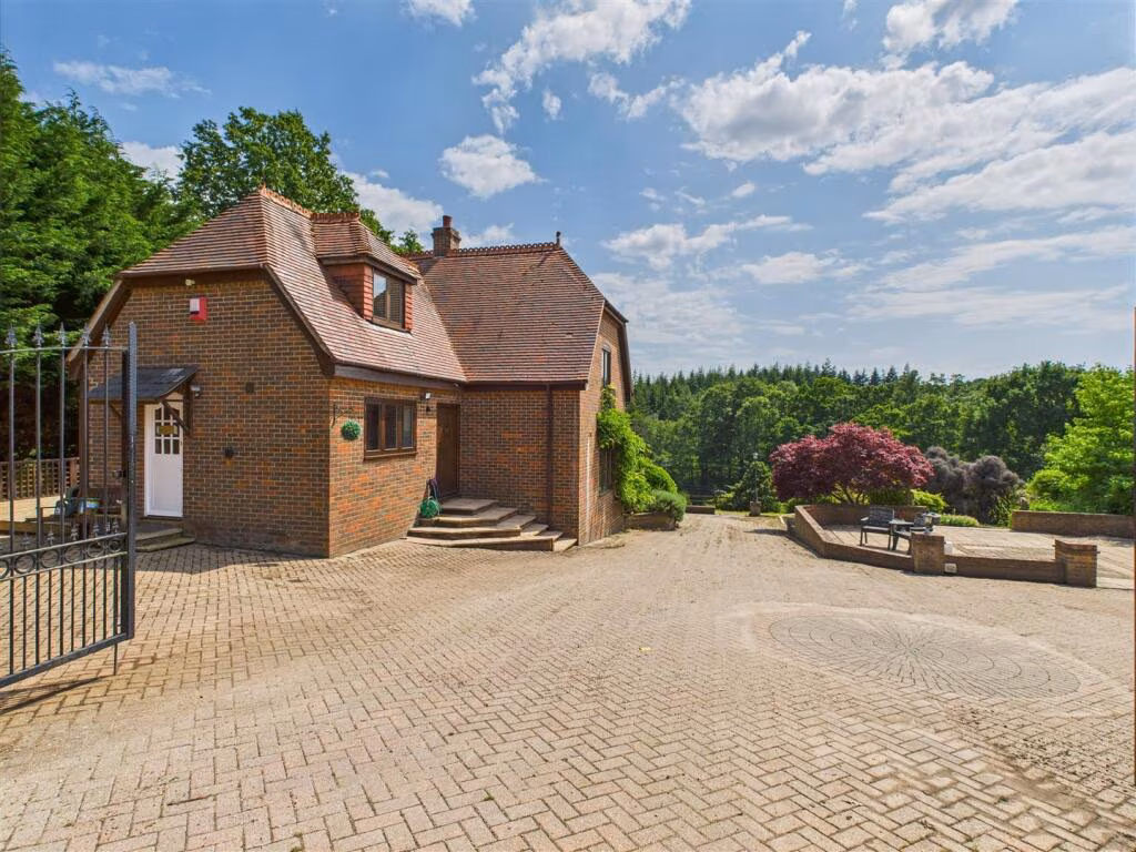
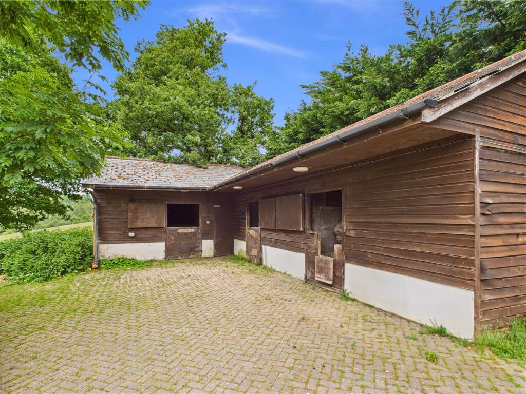
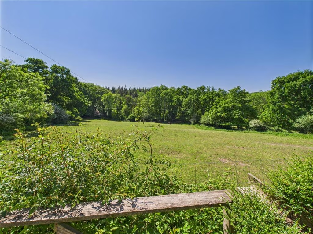
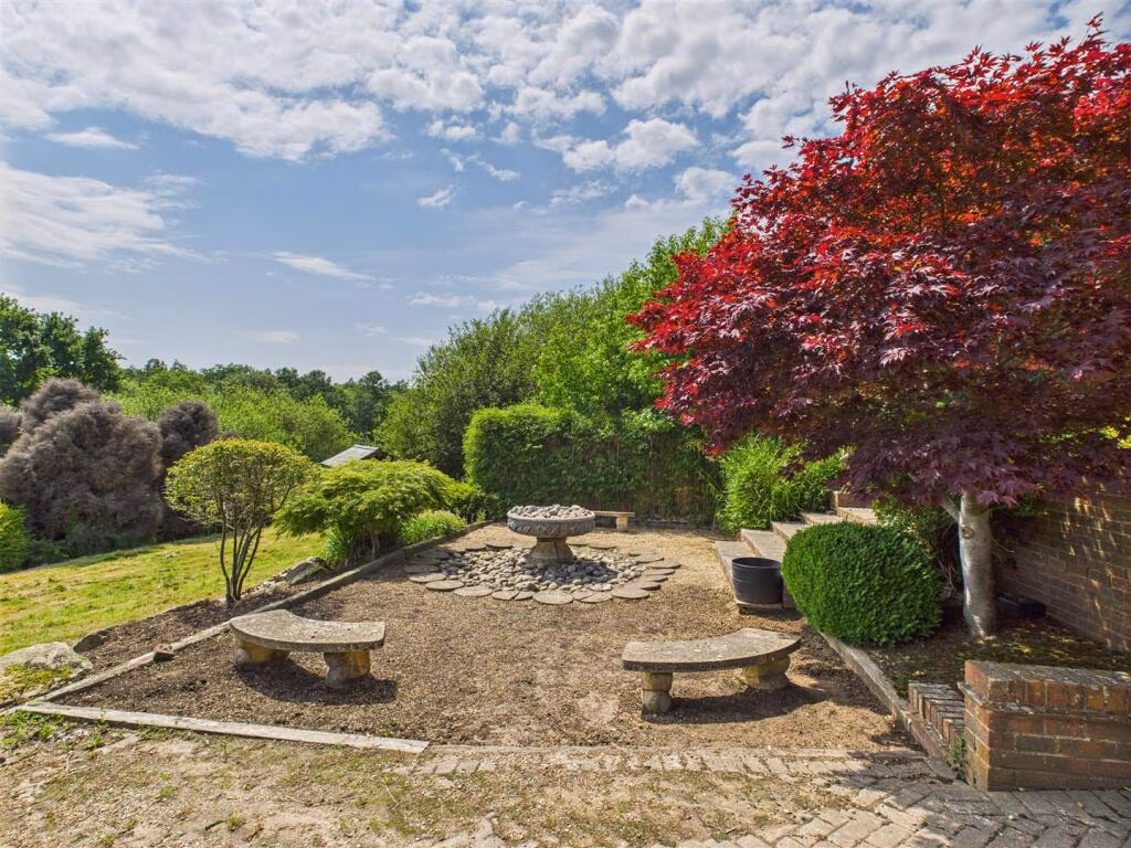
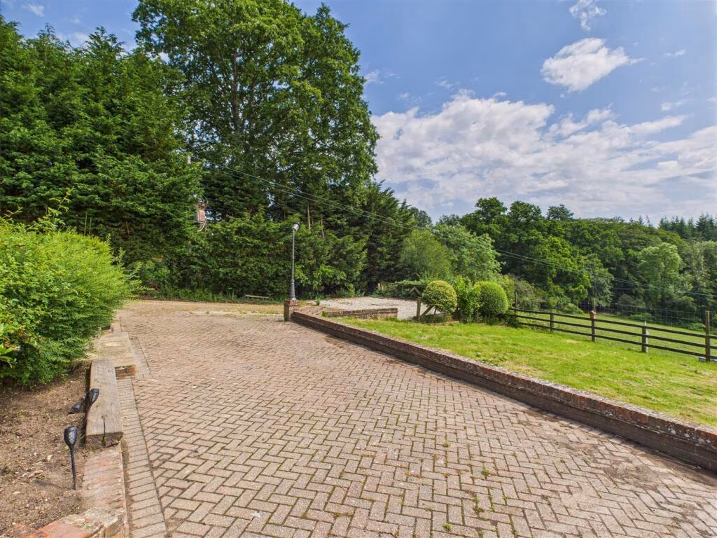
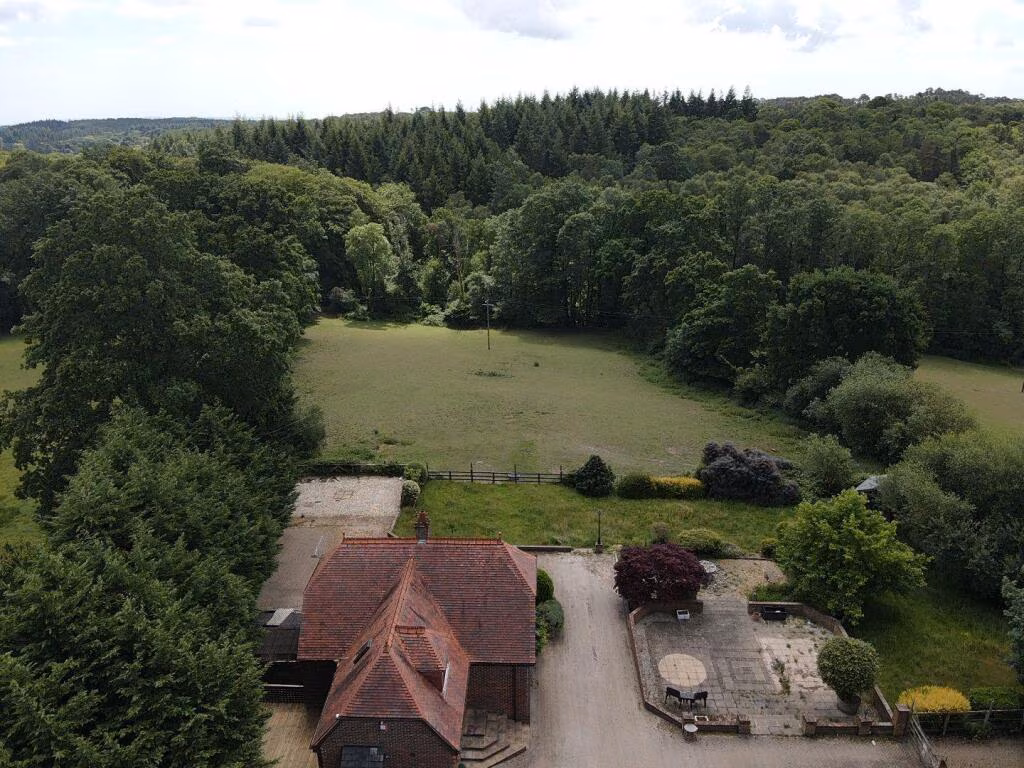
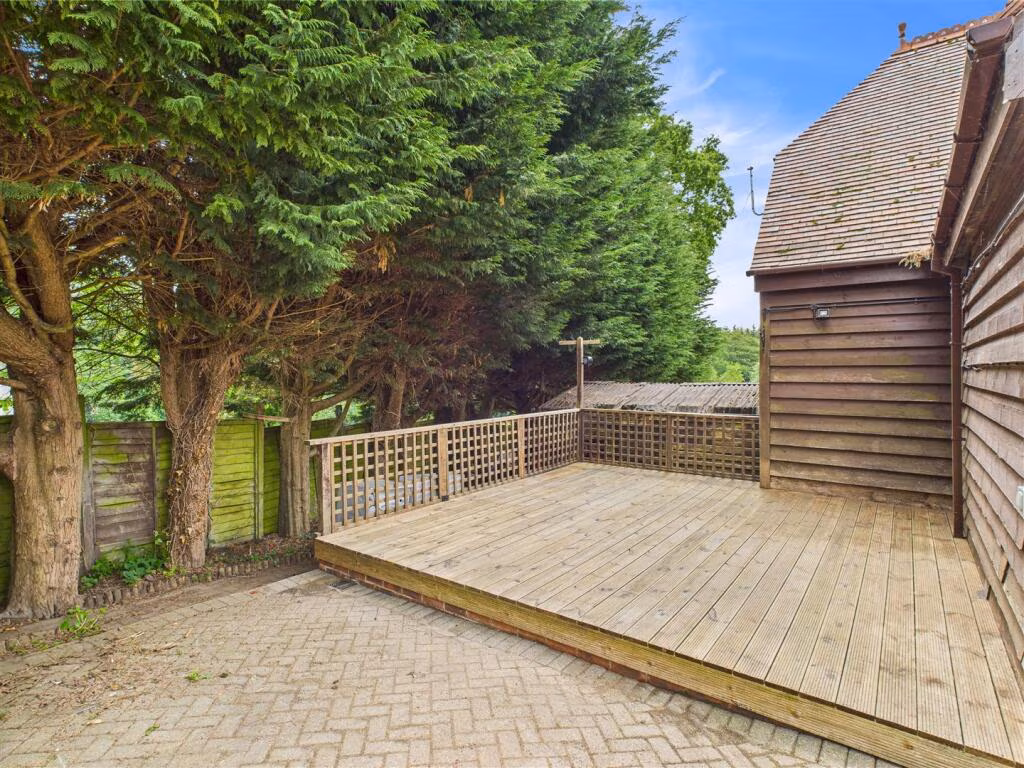
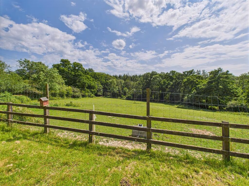
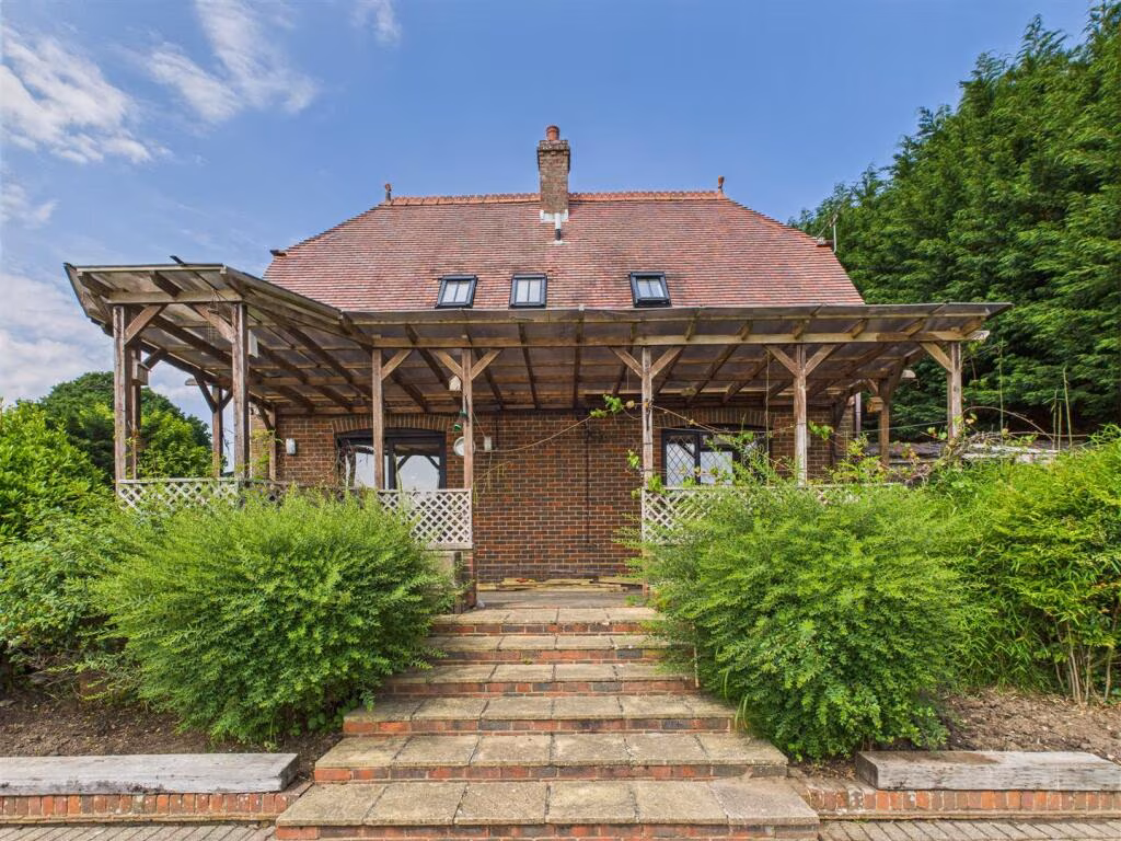
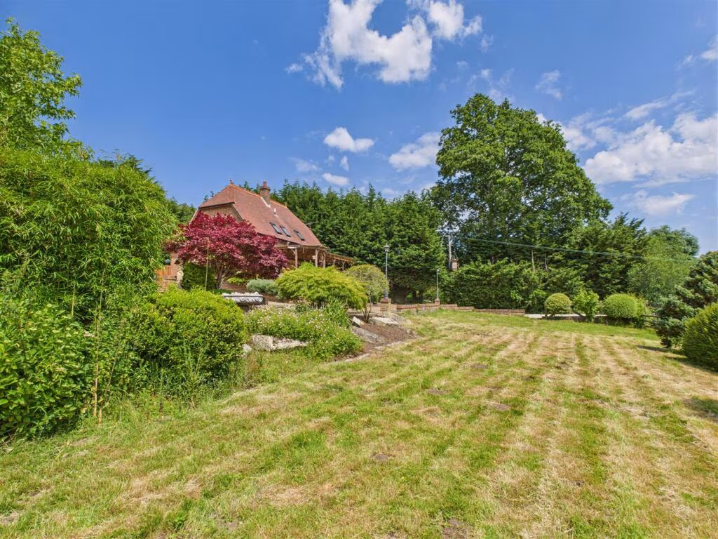
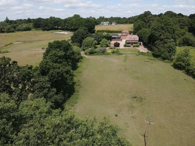
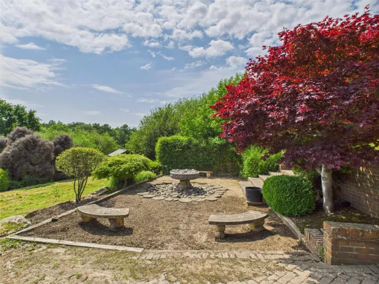
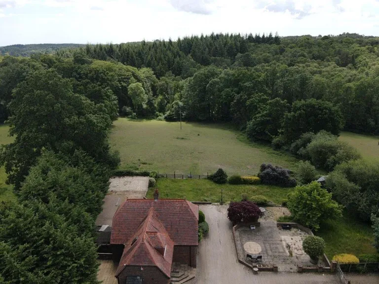
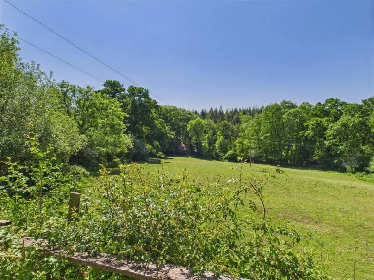
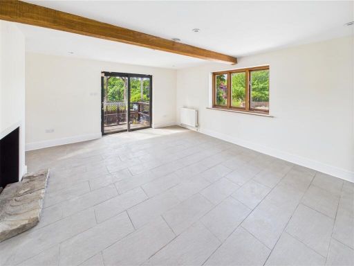
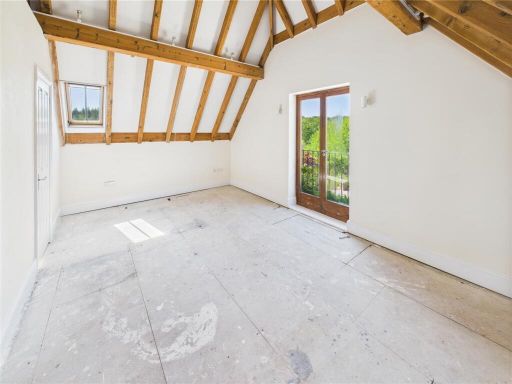
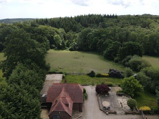
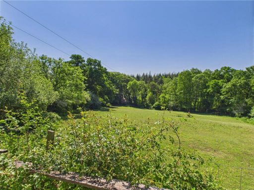
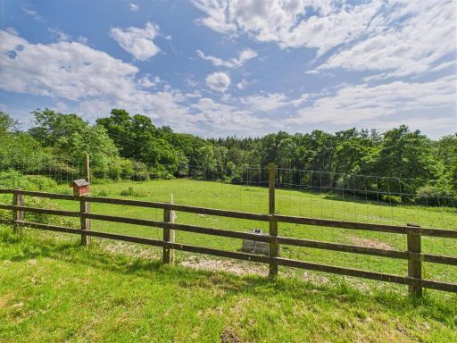
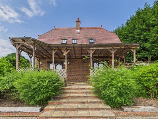
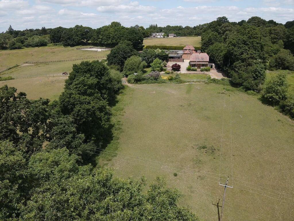
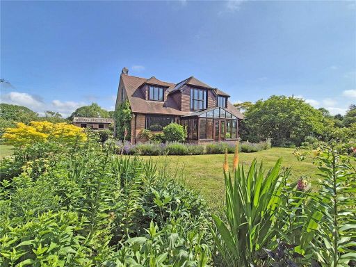
- Detached rural residence set in extensive grounds and paddock land. The property appears to be a traditional farmhouse/converted outbuilding cluster positioned at the head of a large, mainly level pasture with fenced paddocks and a ménage/riding area visible to the rear/left. Heavily treed boundaries and adjoining woodland provide strong privacy and shelter. The immediate garden around the house is of average size given the wider holding, with formal driveway and parking/yard areas. Overall plot size is large (several acres apparent) with agricultural/equestrian potential; the built footprint appears modest (single main house with attached outbuildings). Views are predominantly over open pasture and mature woodland. In valuator terms: a countryside property with substantial land component, good privacy and equestrian scope, likely to appeal to buyers seeking a small country holding near Lyndhurst.
- No property photos or details of the residential property for sale are present in the provided image. The image only contains estate agent contact information (telephone, email and office address). Therefore no accurate description of the property (size, rooms, views or garden) can be inferred from this image.
Image Descriptions
- a rural house rural traditional
- outbuilding/stables rustic
Floorplan Description
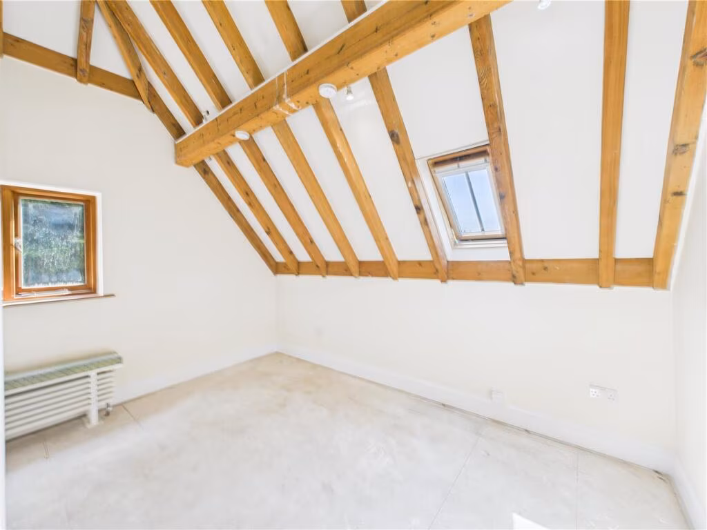
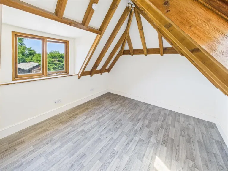
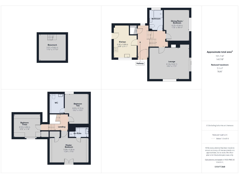
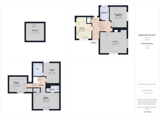
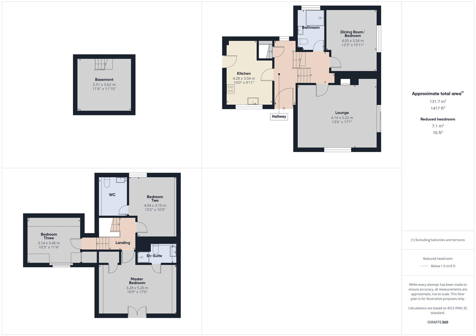
- Multi-story house with basement, ground floor and first floor
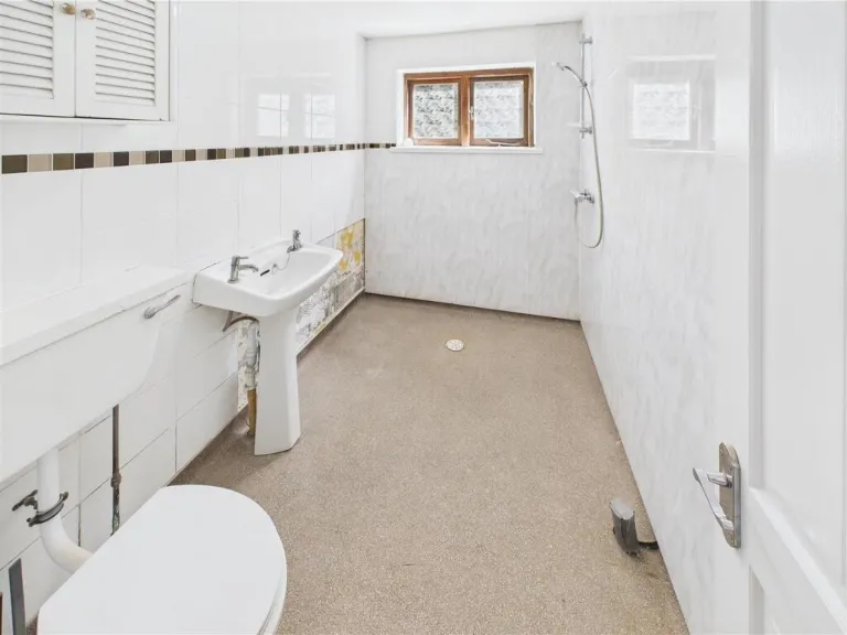
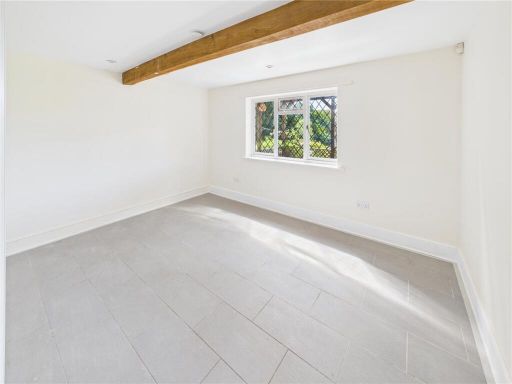
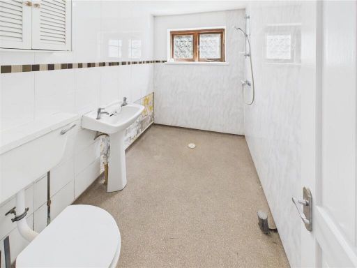
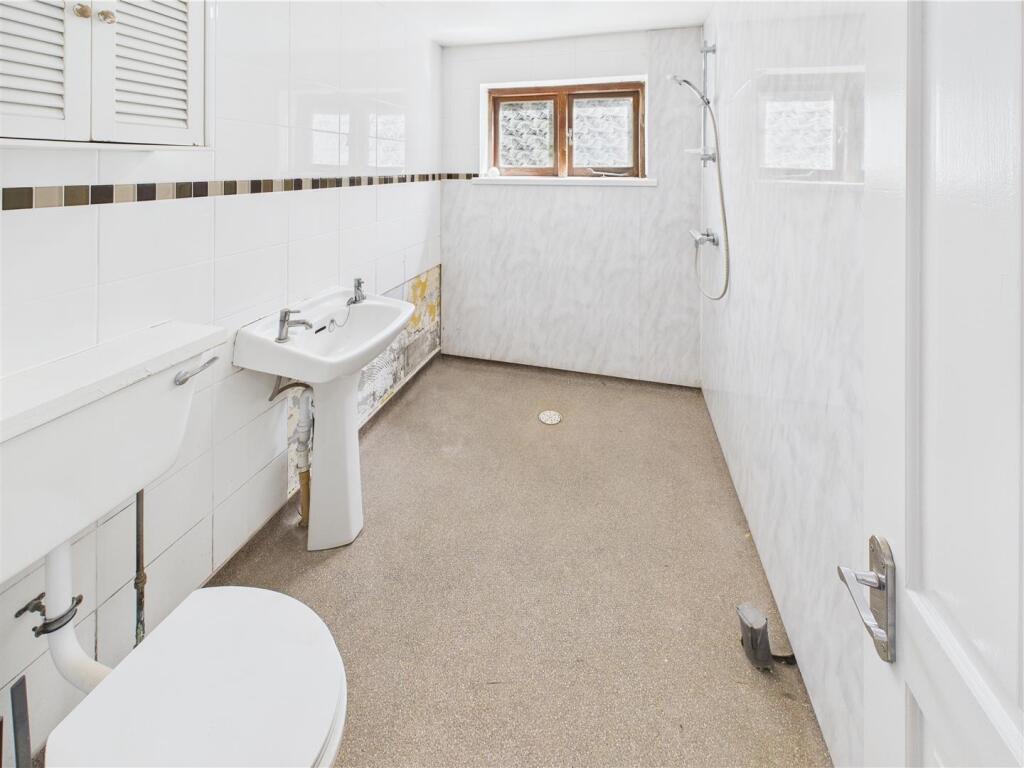
Rooms
- Basement:
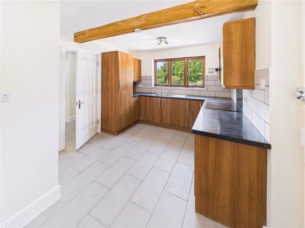
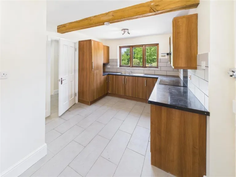
- Kitchen:
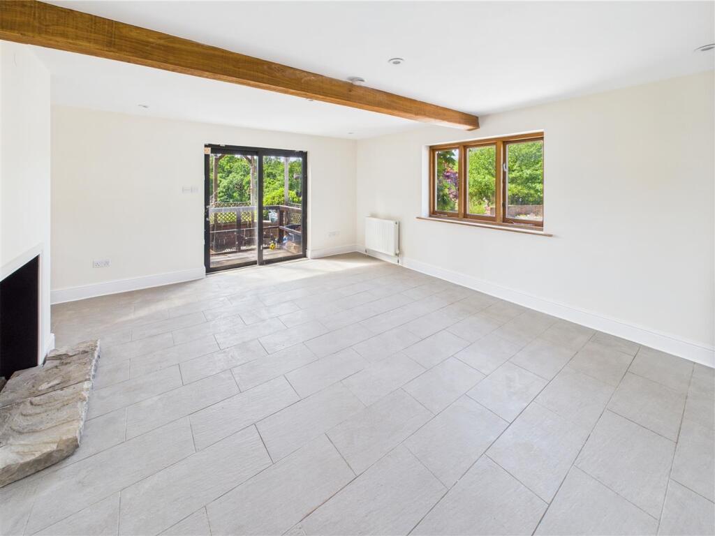
- Lounge:
- Dining Room/Bedroom:
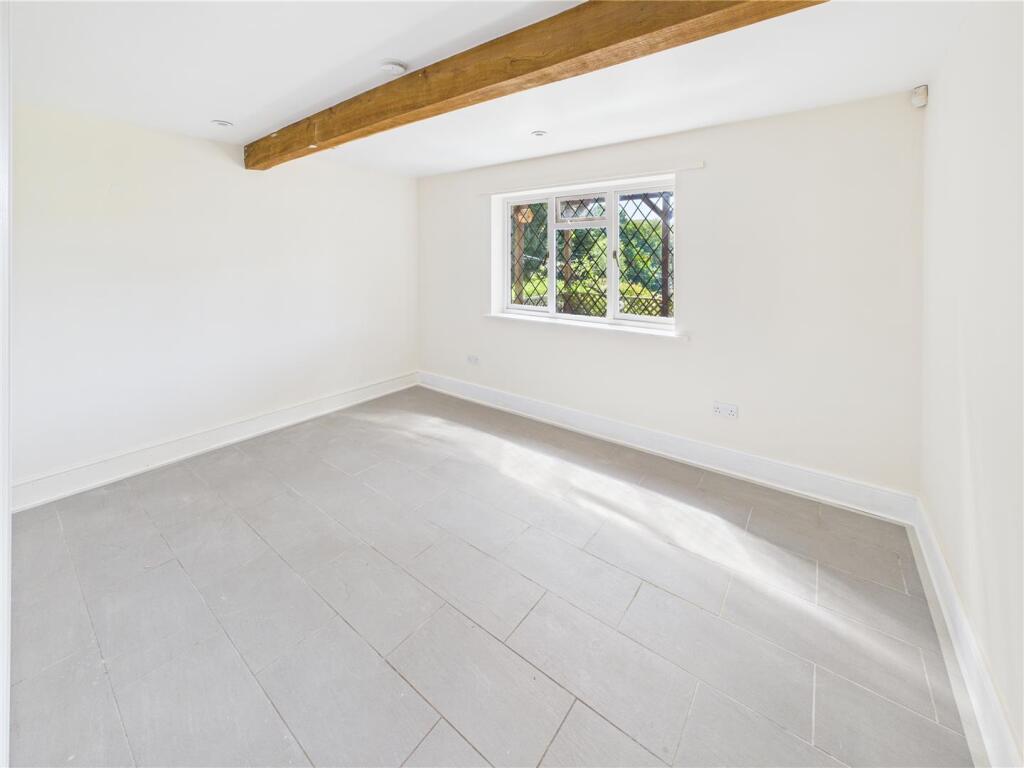
- Bedroom Two:
- Bedroom Three:
- Master Bedroom:
Textual Property Features
Detected Visual Features
- countryside
- brick exterior
- sloped roof
- driveway
- nature view
- trees
- privacy
- quiet
- traditional style
- stables
- rustic
- outbuilding
- wooden structure
- country property
- green surroundings
- equine facilities
- property with potential
EPC Details
- Fully double glazed
- Cavity wall, as built, no insulation (assumed)
- Boiler and radiators, mains gas
- Low energy lighting in 71% of fixed outlets
- Solid, no insulation (assumed)
Nearby Schools
- Netley Marsh Church of England Infant School
- Bartley Church of England Junior School
- Calmore Junior School
- The New Forest Church of England Primary School
- Calmore Infant School
- Wellow Primary School
- St Michael and All Angels CofE Infant School
- Foxhills Junior School
- New Forest Small School
- Foxhills Infant School
- Hazel Wood Infant School
- Copythorne CofE Infant School
Nearest Bars And Restaurants
- Id: 648842966
- Tags:
- Addr:
- City: New Forest
- Housename: The Green Dragon
- Postcode: SO43 7HE
- Amenity: pub
- Building: yes
- Name: The Green Dragon
- Website: https://www.greendragonbrook.co.uk/
- TagsNormalized:
- Lat: 50.9253335
- Lon: -1.6126862
- FullGeoHash: gcnceq9ttdnp
- PartitionGeoHash: gcnc
- Images:
- FoodStandards: null
- Distance: 2426.4
,- Id: 5034493243
- Tags:
- Amenity: pub
- Name: Green Dragon
- Wikidata: Q26459976
- TagsNormalized:
- Lat: 50.9253025
- Lon: -1.6126773
- FullGeoHash: gcnceq9tmukw
- PartitionGeoHash: gcnc
- Images:
- FoodStandards: null
- Distance: 2423.2
,- Id: 254675258
- Tags:
- Addr:
- City: Lyndhurst
- Country: GB
- Place: Minstead
- Postcode: SO43 7FY
- Amenity: pub
- Building: yes
- Cuisine: regional
- Email: info@thetrustyservant.co.uk
- Internet_access: wlan
- Name: The Trusty Servant Inn
- Phone: +442380812137
- Website: https://www.thetrustyservant.co.uk/
- TagsNormalized:
- Lat: 50.8981783
- Lon: -1.6012121
- FullGeoHash: gcnce9dp3h1s
- PartitionGeoHash: gcnc
- Images:
- FoodStandards: null
- Distance: 1577.9
,- Id: 650086636
- Tags:
- Addr:
- City: Lyndhurst
- Housename: Sir Walter Tyrrell
- Postcode: SO43 7HD
- Street: Rufus Stone
- Amenity: pub
- Building: yes
- Name: Sir Walter Tyrrell
- Website: https://www.thesirwaltertyrrell.co.uk/
- TagsNormalized:
- Lat: 50.9133841
- Lon: -1.6193029
- FullGeoHash: gcncehkzgw8n
- PartitionGeoHash: gcnc
- Images:
- FoodStandards: null
- Distance: 1028.9
,- Id: 271421
- Tags:
- Amenity: pub
- Name: Sir Walter Tyrrell
- TagsNormalized:
- Lat: 50.9133439
- Lon: -1.6192629
- FullGeoHash: gcncehkzsrnn
- PartitionGeoHash: gcnc
- Images:
- FoodStandards: null
- Distance: 1024.9
}
Nearest General Shops
- Id: 271078
- Tags:
- Name: Acres Down Farm
- Shop: tea
- TagsNormalized:
- Lat: 50.8872225
- Lon: -1.6186833
- FullGeoHash: gcnc7ptr9cy6
- PartitionGeoHash: gcnc
- Images:
- FoodStandards: null
- Distance: 1903.1
,- Id: 5037499567
- Tags:
- Name: Acres Down Farm
- Shop: farm
- TagsNormalized:
- Lat: 50.8874294
- Lon: -1.6184358
- FullGeoHash: gcnc7pv2z8qu
- PartitionGeoHash: gcnc
- Images:
- FoodStandards: null
- Distance: 1882.1
,- Id: 4453900611
- Tags:
- TagsNormalized:
- Lat: 50.9021478
- Lon: -1.6130043
- FullGeoHash: gcnce63qw20g
- PartitionGeoHash: gcnc
- Images:
- FoodStandards: null
- Distance: 643.3
}
Nearest Grocery shops
- Id: 2010335135
- Tags:
- Name: Bramshaw Village Store and Newsagents
- Shop: convenience
- TagsNormalized:
- Lat: 50.9300593
- Lon: -1.6165312
- FullGeoHash: gcncepwch54v
- PartitionGeoHash: gcnc
- Images:
- FoodStandards: null
- Distance: 2892.4
,- Id: 935200249
- Tags:
- Addr:
- City: Lyndhurst
- Country: GB
- Place: Minstead
- Postcode: SO43 7FY
- Name: Minstead Village Shop
- Shop: convenience
- TagsNormalized:
- Lat: 50.8977773
- Lon: -1.6007813
- FullGeoHash: gcnce9dm516g
- PartitionGeoHash: gcnc
- Images:
- FoodStandards: null
- Distance: 1624.5
,- Id: 1060028396
- Tags:
- Addr:
- City: Stoney Cross, Lyndhurst
- Housename: Rufus Stone Services, A31 Westbound
- Postcode: SO43 7GN
- Street: Ringwood Road
- Brand: Londis
- Brand:wikidata: Q21008564
- Building: yes
- Name: Londis
- Note: When I passed this service station on Thursday 9th December 2021, this shop may have changed from a Hursts to a Londis. If somebody could check this please and confirm it here on OSM.
Confirmed Londis from survey 20th August 2021.
- Opening_hours: 24/7
- Phone: +44 2380 814663
- Shop: convenience
- Source: survey
- TagsNormalized:
- Lat: 50.9059888
- Lon: -1.625495
- FullGeoHash: gcnce50kghp5
- PartitionGeoHash: gcnc
- Images:
- FoodStandards: null
- Distance: 337.7
}
Nearest Supermarkets
- Id: 750236196
- Tags:
- Addr:
- City: Southampton
- Housenumber: 23
- Postcode: SO40 9DQ
- Street: Rumbridge Street
- Suburb: Totton
- Brand: Co-op Food
- Brand:wikidata: Q3277439
- Brand:wikipedia: en:Co-op Food
- Building: yes
- Name: Co-op Food
- Shop: supermarket
- TagsNormalized:
- co-op
- co-op food
- food
- supermarket
- shop
- Lat: 50.9153462
- Lon: -1.4859564
- FullGeoHash: gcncwhvgqsqw
- PartitionGeoHash: gcnc
- Images:
- FoodStandards: null
- Distance: 9587.2
,- Id: 23134411
- Tags:
- Addr:
- City: Southampton
- Postcode: SO40 3ZA
- Street: Maynard Road
- Suburb: Totton
- Brand: Asda
- Brand:wikidata: Q297410
- Brand:wikipedia: en:Asda
- Building: yes
- Contact:
- Facebook: https://www.facebook.com/asda/
- Twitter: @asda
- Website: https://storelocator.asda.com/south-east/totton/maynard-road
- Fhrs:
- Name: Asda
- Operator: Asda Stores Ltd
- Shop: supermarket
- Source:
- TagsNormalized:
- Lat: 50.9180018
- Lon: -1.4883309
- FullGeoHash: gcncwjk4z7kp
- PartitionGeoHash: gcnc
- Images:
- FoodStandards:
- Id: 547700
- FHRSID: 547700
- LocalAuthorityBusinessID: 43
- BusinessName: ASDA STORES LTD
- BusinessType: Retailers - supermarkets/hypermarkets
- BusinessTypeID: 7840
- AddressLine1: MAYNARD ROAD
- AddressLine2: TOTTON
- AddressLine3: SOUTHAMPTON
- AddressLine4: null
- PostCode: SO40 3ZA
- RatingValue: 5
- RatingKey: fhrs_5_en-GB
- RatingDate: 2022-02-10
- LocalAuthorityCode: 138
- LocalAuthorityName: New Forest
- LocalAuthorityWebSite: http://www.newforest.gov.uk
- LocalAuthorityEmailAddress: hygiene.rating@nfdc.gov.uk
- Scores:
- Hygiene: 0
- Structural: 5
- ConfidenceInManagement: 0
- NewRatingPending: false
- Geocode:
- Longitude: -1.48800200000000
- Latitude: 50.91812900000000
- Distance: 9465.1
,- Id: 335134053
- Tags:
- Brand: Morrisons
- Brand:wikidata: Q922344
- Brand:wikipedia: en:Morrisons
- Building: yes
- Contact:
- Website: https://my.morrisons.com/storefinder/364
- Name: Morrisons
- Shop: supermarket
- TagsNormalized:
- Lat: 50.9226046
- Lon: -1.5223513
- FullGeoHash: gcnctq5mwts8
- PartitionGeoHash: gcnc
- Images:
- FoodStandards: null
- Distance: 7248.6
}
Nearest Religious buildings
- Id: 190653816
- Tags:
- Amenity: place_of_worship
- Building: church
- Denomination: anglican
- Name: Emery Down Church
- Religion: christian
- Source: Bing
- Wikidata: Q26387050
- TagsNormalized:
- place of worship
- church
- anglican
- christian
- Lat: 50.8740581
- Lon: -1.5933662
- FullGeoHash: gcnc7trdzgu1
- PartitionGeoHash: gcnc
- Images:
- FoodStandards: null
- Distance: 3895.4
,- Id: 289910050
- Tags:
- Amenity: place_of_worship
- Denomination: methodist
- Name: Methodist Church
- Religion: christian
- Source: Bing
- TagsNormalized:
- place of worship
- methodist
- church
- christian
- Lat: 50.9225098
- Lon: -1.5809415
- FullGeoHash: gcncsn0v17ue
- PartitionGeoHash: gcnc
- Images:
- FoodStandards: null
- Distance: 3497.8
,- Id: 254675872
- Tags:
- Amenity: place_of_worship
- Building: church
- Denomination: anglican
- Heritage: yes
- Name: All Saints
- Religion: christian
- Wikidata: Q17528422
- TagsNormalized:
- place of worship
- church
- anglican
- christian
- Lat: 50.8966817
- Lon: -1.6016909
- FullGeoHash: gcnce93wtvhs
- PartitionGeoHash: gcnc
- Images:
- FoodStandards: null
- Distance: 1627
}
Nearest Medical buildings
- Id: 730125261
- Tags:
- Amenity: pharmacy
- Brand: Rowlands Pharmacy
- Brand:wikidata: Q62663235
- Building: yes
- Dispensing: yes
- Healthcare: pharmacy
- Name: Rowlands Pharmacy
- TagsNormalized:
- pharmacy
- rowlands pharmacy
- health
- healthcare
- Lat: 50.8723596
- Lon: -1.5754738
- FullGeoHash: gcnckjhbbz1t
- PartitionGeoHash: gcnc
- Images:
- FoodStandards: null
- Distance: 4797.5
,- Id: 730125290
- Tags:
- Amenity: dentist
- Building: yes
- Healthcare: dentist
- Name: The Lyndhurst Dental Practice
- TagsNormalized:
- dentist
- health
- healthcare
- dental
- Lat: 50.8738763
- Lon: -1.5760886
- FullGeoHash: gcnckjk3f3zh
- PartitionGeoHash: gcnc
- Images:
- FoodStandards: null
- Distance: 4644.5
,- Id: 1721062155
- Tags:
- Amenity: pharmacy
- Healthcare: pharmacy
- TagsNormalized:
- Lat: 50.9180391
- Lon: -1.5646668
- FullGeoHash: gcncsmkehd7y
- PartitionGeoHash: gcnc
- Images:
- FoodStandards: null
- Distance: 4273.5
,- Id: 2503627996
- Tags:
- Amenity: clinic
- Name: Fenwick2 Health & Wellbeing Centre
- TagsNormalized:
- Lat: 50.8794056
- Lon: -1.5834828
- FullGeoHash: gcnc7yqfn0ts
- PartitionGeoHash: gcnc
- Images:
- FoodStandards: null
- Distance: 3841.6
}
Nearest Airports
- Id: 100647893
- Tags:
- Aerodrome: international
- Aerodrome:type: public
- Aeroway: aerodrome
- Contact:
- Vhf:
- Approach: 120.225 MHz
- Tower: 118.2 MHz
- Ele: 44ft
- Iata: SOU
- Icao: EGHI
- Is_in: Hampshire, England,UK
- Name: Southampton Airport
- Operator: Southampton International Airport Limited
- Source: Bing;Gagravarr_Airports
- Wikidata: Q8988
- Wikipedia: en:Southampton Airport
- TagsNormalized:
- airport
- international airport
- Lat: 50.9513872
- Lon: -1.3516684
- FullGeoHash: gcp1c5rtrffz
- PartitionGeoHash: gcp1
- Images:
- FoodStandards: null
- Distance: 19628.4
,- Id: 386864426
- Tags:
- Aerodrome: international
- Aeroway: aerodrome
- Alt_name: Bournemouth International Airport
- Ele: 12
- Iata: BOH
- Icao: EGHH
- Int_name: B
- Name: Bournemouth Airport
- Old_name: Hurn Airport
- Ref: EGHH
- Source: wikipedia
- Wikidata: Q580409
- Wikipedia: en:Bournemouth Airport
- TagsNormalized:
- airport
- international airport
- Lat: 50.7825186
- Lon: -1.84232
- FullGeoHash: gcn8yhdmwgde
- PartitionGeoHash: gcn8
- Images:
- FoodStandards: null
- Distance: 20578.1
}
Nearest Leisure Facilities
- Id: 948271071
- Tags:
- Leisure: pitch
- Sport: tennis
- TagsNormalized:
- Lat: 50.8997765
- Lon: -1.628754
- FullGeoHash: gcncdfjbxq0c
- PartitionGeoHash: gcnc
- Images:
- FoodStandards: null
- Distance: 708
,- Id: 84955040
- Tags:
- Access: customers
- Fee: yes
- Garden:
- Leisure: garden
- Name: Furzey Gardens
- Tourism: attraction
- Website: https://www.minsteadtrust.org.uk/furzey-gardens/
- TagsNormalized:
- Lat: 50.900952
- Lon: -1.6131202
- FullGeoHash: gcnce61re94m
- PartitionGeoHash: gcnc
- Images:
- FoodStandards: null
- Distance: 695.5
,- Id: 948271128
- Tags:
- TagsNormalized:
- swimming
- swimming pool
- pool
- leisure
- Lat: 50.8995606
- Lon: -1.6281172
- FullGeoHash: gcncdcyrqjgc
- PartitionGeoHash: gcnc
- Images:
- FoodStandards: null
- Distance: 694.6
,- Id: 1112779653
- Tags:
- Access: private
- Leisure: pitch
- Sport: equestrian
- TagsNormalized:
- pitch
- leisure
- equestrian
- sports
- Lat: 50.9050891
- Lon: -1.6256705
- FullGeoHash: gcnce4bpxhkh
- PartitionGeoHash: gcnc
- Images:
- FoodStandards: null
- Distance: 303.5
,- Id: 1112779651
- Tags:
- Access: private
- Leisure: swimming_pool
- TagsNormalized:
- swimming
- swimming pool
- pool
- leisure
- Lat: 50.905053
- Lon: -1.6174903
- FullGeoHash: gcnce4ypmtxv
- PartitionGeoHash: gcnc
- Images:
- FoodStandards: null
- Distance: 299.1
}
Nearest Tourist attractions
- Id: 83295704
- Tags:
- Name: Long Beech
- Natural: heath
- Tourism: camp_site
- TagsNormalized:
- Lat: 50.9142372
- Lon: -1.6388348
- FullGeoHash: gcncdswsumsp
- PartitionGeoHash: gcnc
- Images:
- FoodStandards: null
- Distance: 1644.1
,- Id: 969181211
- Tags:
- TagsNormalized:
- Lat: 50.913661
- Lon: -1.6370015
- FullGeoHash: gcncdsxcx471
- PartitionGeoHash: gcnc
- Images:
- FoodStandards: null
- Distance: 1506.6
,- Id: 248634710
- Tags:
- Historic: memorial
- Name: Rufus Stone
- Tourism: attraction
- TagsNormalized:
- Lat: 50.9111785
- Lon: -1.6170541
- FullGeoHash: gcncehn7pgt1
- PartitionGeoHash: gcnc
- Images:
- FoodStandards: null
- Distance: 833.5
}
Nearest Hotels
- Id: 911683965
- Tags:
- Accommodation: yes
- Amenity: restaurant
- Building: yes
- Cuisine: french
- Name: Le Chateau Hotel & Bistro
- TagsNormalized:
- Lat: 50.926088
- Lon: -1.5751901
- FullGeoHash: gcncsnuczqv5
- PartitionGeoHash: gcnc
- Images:
- FoodStandards: null
- Distance: 4058
,- Id: 151876202
- Tags:
- Addr:
- City: Southampton
- Housename: The Bartley Lodge Hotel
- Postcode: SO40 2NR
- Street: Lyndhurst Road
- Building: yes
- Name: The Bartley Lodge Hotel
- Phone: +44 2380812248
- Tourism: hotel
- Wikidata: Q4865447
- Wikipedia: en:Bartley Lodge
- TagsNormalized:
- Lat: 50.916459
- Lon: -1.5771806
- FullGeoHash: gcncsj59c5bu
- PartitionGeoHash: gcnc
- Images:
- FoodStandards: null
- Distance: 3395
,- Id: 1060028391
- Tags:
- Brand: Travelodge
- Brand:wikidata: Q9361374
- Building: yes
- Internet_access: wlan
- Internet_access:fee: customers
- Internet_access:ssid: Travelodge WiFi
- Name: Travelodge Stoney Cross Lyndhurst
- Tourism: hotel
- TagsNormalized:
- Lat: 50.9059824
- Lon: -1.624477
- FullGeoHash: gcnce51hffyj
- PartitionGeoHash: gcnc
- Images:
- FoodStandards: null
- Distance: 281.9
}
Tags
- countryside
- brick exterior
- sloped roof
- driveway
- nature view
- trees
- privacy
- quiet
- traditional style
- stables
- rustic
- outbuilding
- wooden structure
- country property
- green surroundings
- equine facilities
- property with potential
Local Market Stats
- Average Price/sqft: £442
- Avg Income: £54200
- Social Housing: 6%
- Planning Success Rate: 62%
AirBnB Data
- 1km average: £93/night
- Listings in 1km: 2
Similar Properties
 Detached house for sale in Ossemsley, Christchurch, Hampshire, BH23 — £1,350,000 • 1 bed • 1 bath • 2555 ft²
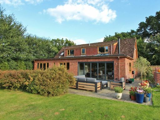 Equestrian facility for sale in Linnies Lane, Sway, Lymington, Hampshire, SO41 — £1,450,000 • 4 bed • 2 bath • 2664 ft²
 4 bedroom bungalow for sale in Wootton Road, Tiptoe, Lymington, Hampshire, SO41 — £1,075,000 • 4 bed • 3 bath • 2657 ft²
 3 bedroom detached house for sale in Ossemsley, Christchurch, Hampshire, BH23 — £1,350,000 • 3 bed • 3 bath • 2544 ft²
 5 bedroom detached house for sale in Picket Hill, Ringwood, BH24 — £1,950,000 • 5 bed • 4 bath • 5062 ft²
 3 bedroom detached house for sale in Shepherds Road, Bartley, Southampton, SO40 — £1,195,000 • 3 bed • 1 bath • 1200 ft²
Meta
- {
"@context": "https://schema.org",
"@type": "Residence",
"name": "3 bedroom detached house for sale in Ringwood Road, Stoney…",
"description": "",
"url": "https://propertypiper.co.uk/property/6de9f2c0-ab29-41a7-a814-e65b919ed54b",
"image": "https://image-a.propertypiper.co.uk/38ec9177-6e21-419b-9833-0b9c247824cd-1024.jpeg",
"address": {
"@type": "PostalAddress",
"streetAddress": "Cartref, Ringwood Road, Stoney Cross",
"postalCode": "SO43 7GN",
"addressLocality": "New Forest",
"addressRegion": "New Forest East",
"addressCountry": "England"
},
"geo": {
"@type": "GeoCoordinates",
"latitude": 50.90424093557945,
"longitude": -1.621556234035575
},
"numberOfRooms": 3,
"numberOfBathroomsTotal": 3,
"floorSize": {
"@type": "QuantitativeValue",
"value": 1417,
"unitCode": "FTK"
},
"offers": {
"@type": "Offer",
"price": 1100000,
"priceCurrency": "GBP",
"availability": "https://schema.org/InStock"
},
"additionalProperty": [
{
"@type": "PropertyValue",
"name": "Feature",
"value": "countryside"
},
{
"@type": "PropertyValue",
"name": "Feature",
"value": "brick exterior"
},
{
"@type": "PropertyValue",
"name": "Feature",
"value": "sloped roof"
},
{
"@type": "PropertyValue",
"name": "Feature",
"value": "driveway"
},
{
"@type": "PropertyValue",
"name": "Feature",
"value": "nature view"
},
{
"@type": "PropertyValue",
"name": "Feature",
"value": "trees"
},
{
"@type": "PropertyValue",
"name": "Feature",
"value": "privacy"
},
{
"@type": "PropertyValue",
"name": "Feature",
"value": "quiet"
},
{
"@type": "PropertyValue",
"name": "Feature",
"value": "traditional style"
},
{
"@type": "PropertyValue",
"name": "Feature",
"value": "stables"
},
{
"@type": "PropertyValue",
"name": "Feature",
"value": "rustic"
},
{
"@type": "PropertyValue",
"name": "Feature",
"value": "outbuilding"
},
{
"@type": "PropertyValue",
"name": "Feature",
"value": "wooden structure"
},
{
"@type": "PropertyValue",
"name": "Feature",
"value": "country property"
},
{
"@type": "PropertyValue",
"name": "Feature",
"value": "green surroundings"
},
{
"@type": "PropertyValue",
"name": "Feature",
"value": "equine facilities"
},
{
"@type": "PropertyValue",
"name": "Feature",
"value": "property with potential"
}
]
}
High Res Floorplan Images
Compatible Floorplan Images
FloorplanImages Thumbnail