BH12 4BZ - 2 bedroom bungalow for sale in Gussage Road, Parkstone, Poo…
View on Property Piper
2 bedroom bungalow for sale in Gussage Road, Parkstone, Poole, BH12
Property Details
- Price: £294000
- Bedrooms: 2
- Bathrooms: 1
- Property Type: undefined
- Property SubType: undefined
Image Descriptions
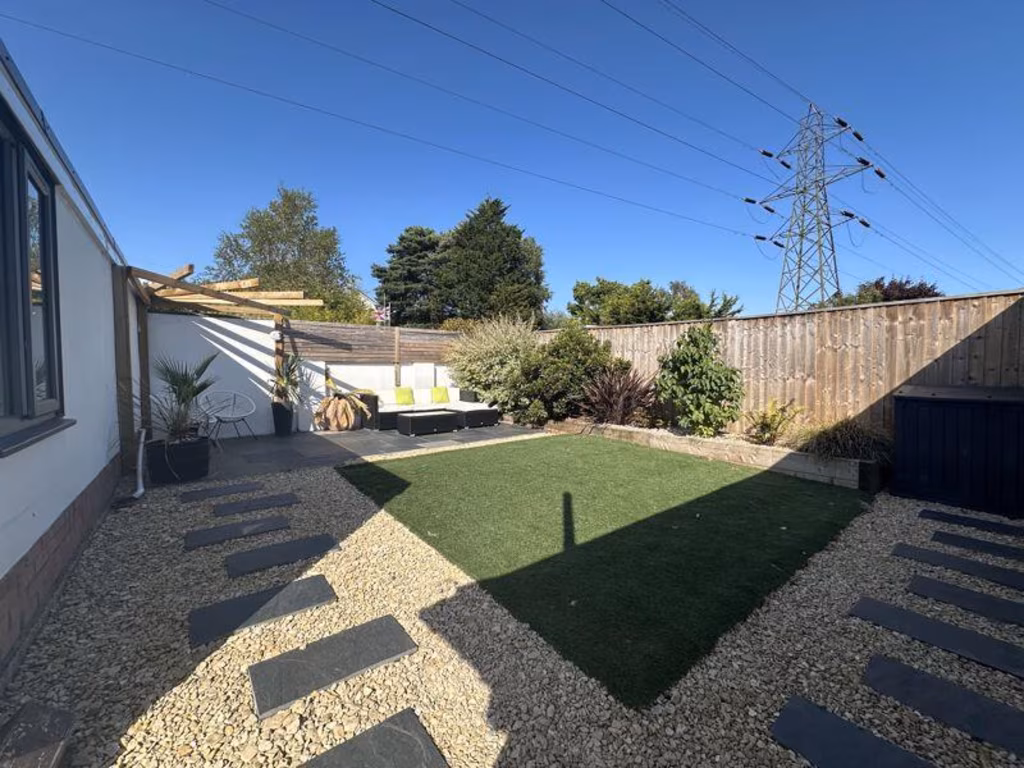
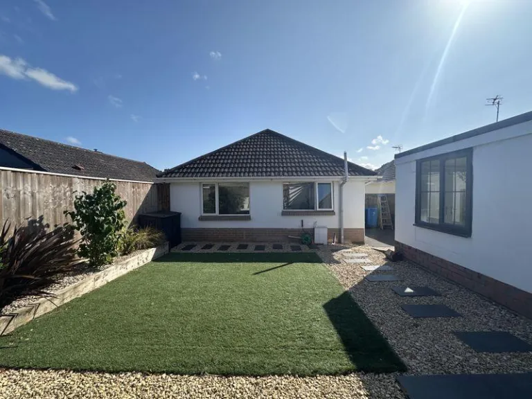
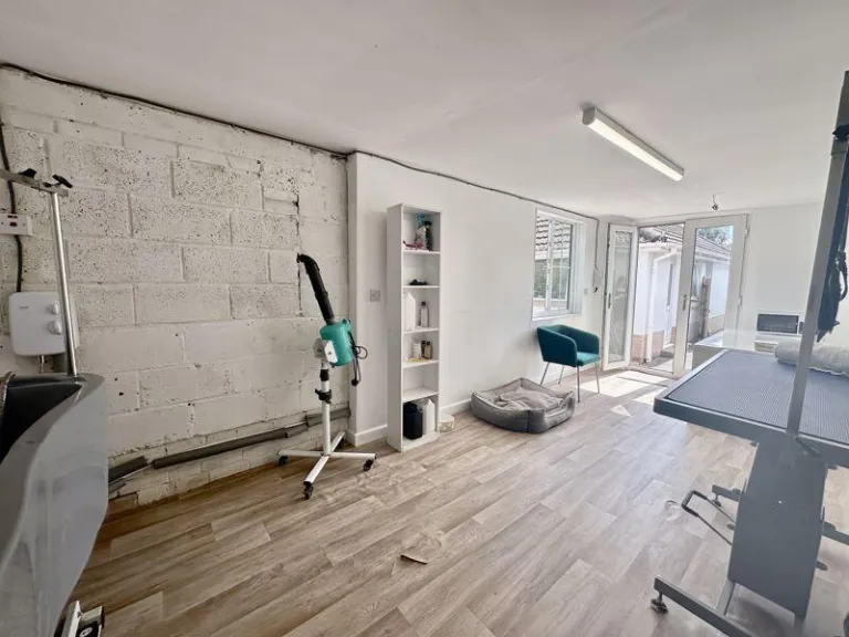
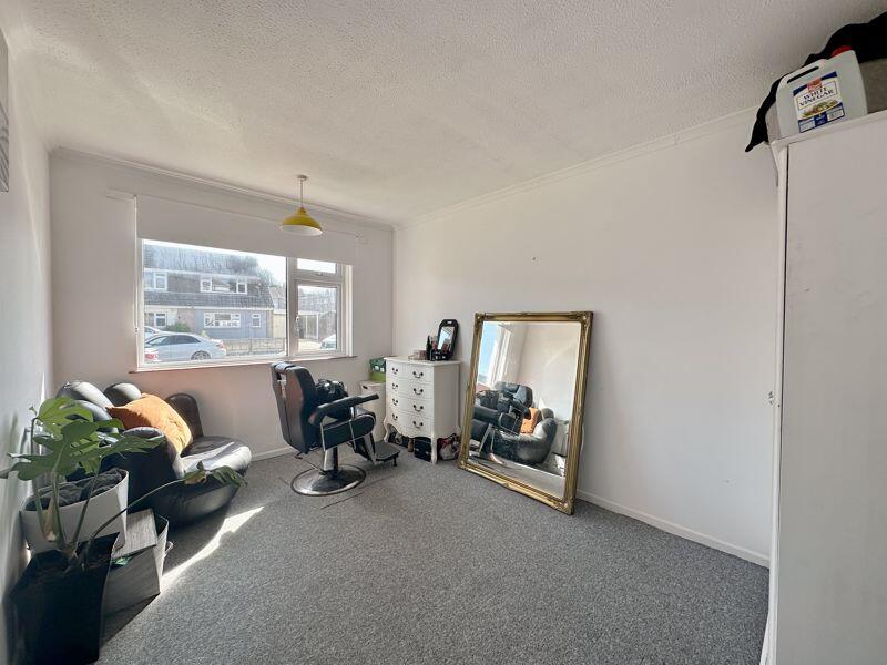
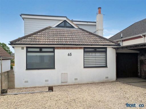
- bungalow 1960s
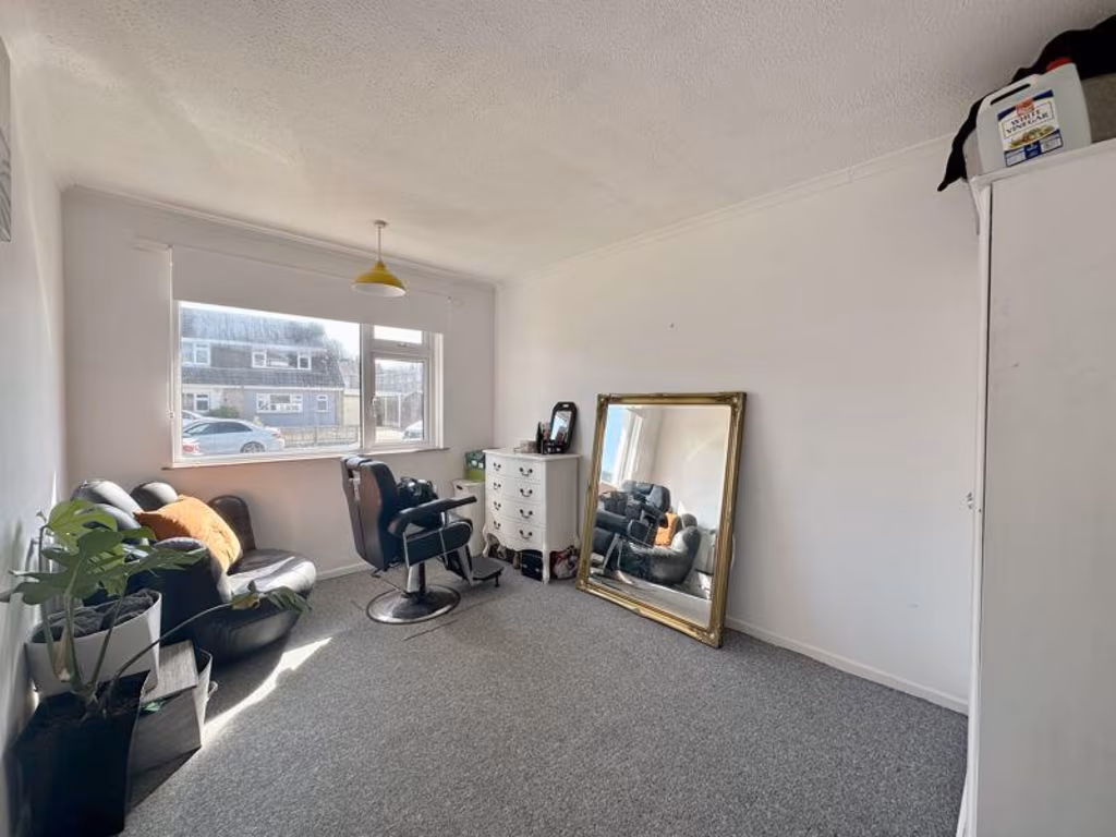
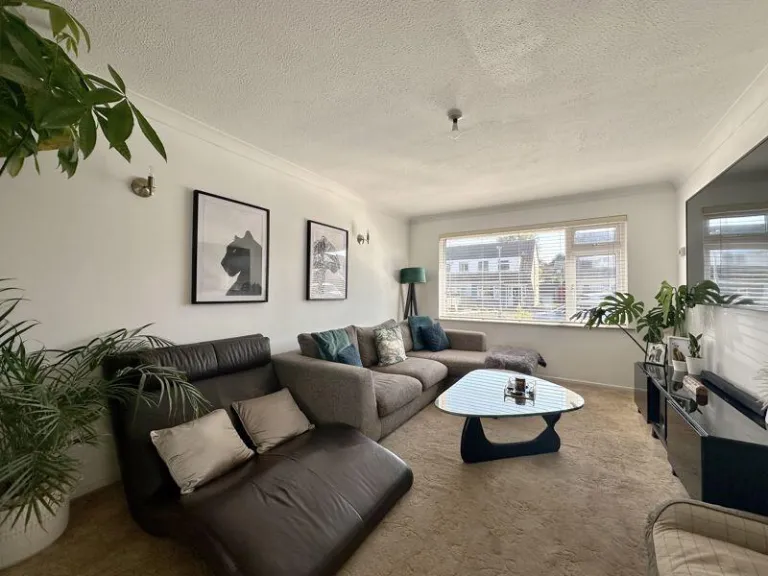
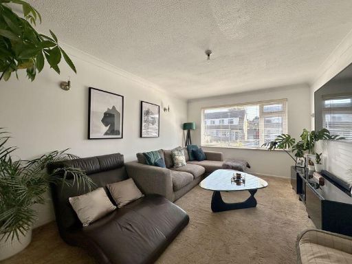
- living room mid-20th century
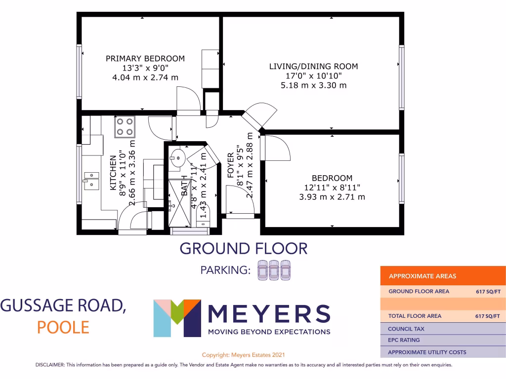
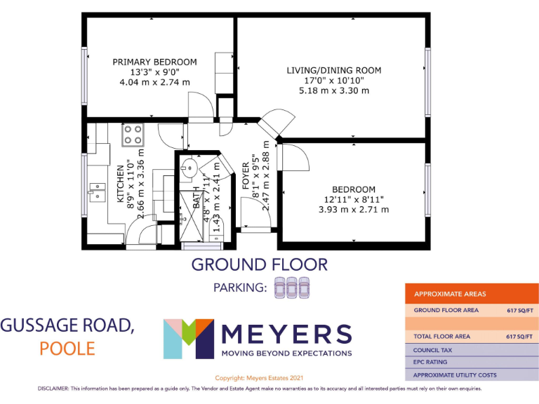
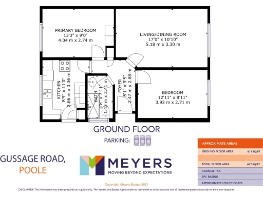
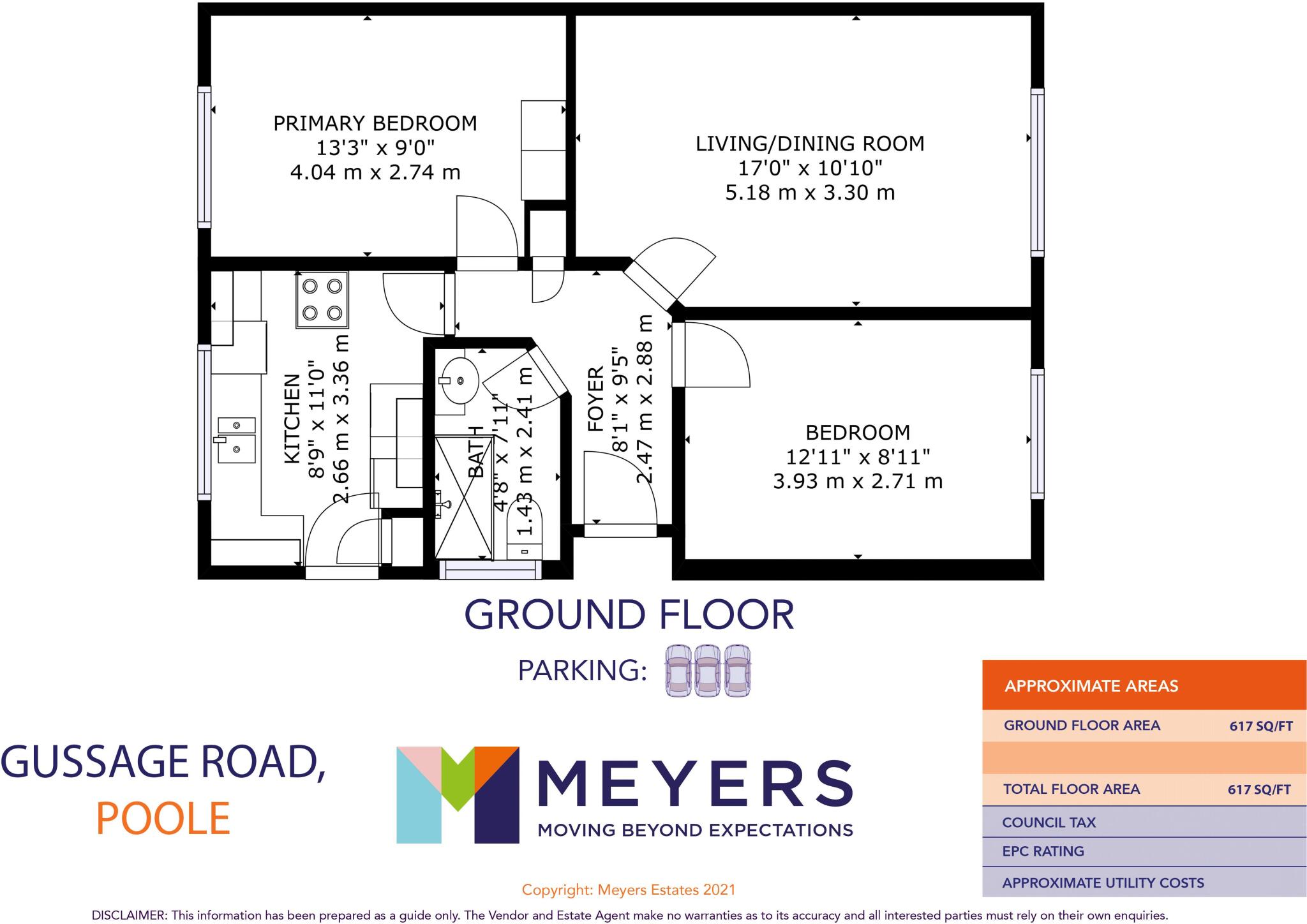
Floorplan Description
- A compact living space in Poole with a practical layout and two bedrooms.
Rooms
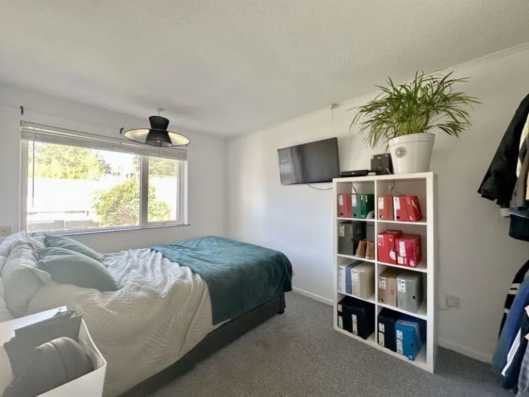
- Primary Bedroom:
- Living/Dining Room:
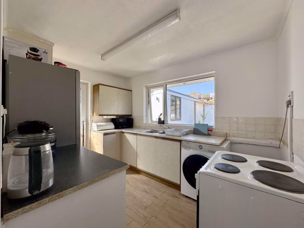
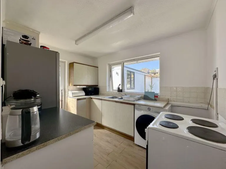
- Kitchen:
- Bedroom:
- Foyer:
Textual Property Features
Detected Visual Features
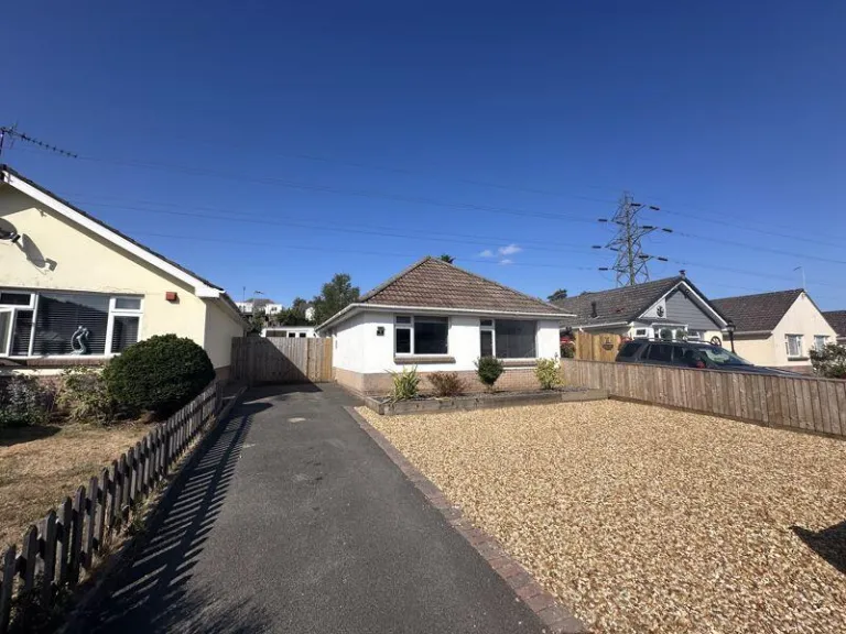
- bungalow
- 1960s
- single-story
- compact
- driveway
- low-maintenance
- suburban
- mid-20th century
- living room
- standard ceiling
- large window
- natural light
- suburban views
EPC Details
- Fully double glazed
- Cavity wall, as built, no insulation (assumed)
- Warm air, mains gas
- Low energy lighting in 75% of fixed outlets
- Solid, no insulation (assumed)
Nearby Schools
- Bournemouth Collegiate Preparatory School
- St Joseph's Catholic Primary School, Poole
- Heathlands Primary Academy
- Baden-Powell and St Peter's Church of England Junior School
- Livingstone Road Infant School
- Livingstone Road Junior School
- St Mark's Church of England Primary School
- Winton Academy
- LeAF Studio
- Kinson Academy
- Bearwood Primary and Nursery School
- Talbot Heath School
- St Aldhelm's Academy
- Talbot Primary School
- Manorside Academy
- Glenmoor Academy
- Oak Academy
- Courthill Infant School
- Heatherlands Primary School
- Bishop Aldhelm's Church of England Primary School
- Kingsleigh Primary School
- The Bourne Academy
- Elm Academy
- Christ The King Catholic Primary School
Nearest General Shops
- Id: 696103087
- Tags:
- Building: yes
- Name: Model Railway Solutions
- Shop: model
- TagsNormalized:
- Lat: 50.7404812
- Lon: -1.9148405
- FullGeoHash: gcn8smj8szr2
- PartitionGeoHash: gcn8
- Images:
- FoodStandards: null
- Distance: 667.2
,- Id: 1106559209
- Tags:
- Building: yes
- Name: Dorset Scrap Store
- Shop: craft
- TagsNormalized:
- Lat: 50.740369
- Lon: -1.9150438
- FullGeoHash: gcn8smj804rf
- PartitionGeoHash: gcn8
- Images:
- FoodStandards: null
- Distance: 660
,- Id: 695637979
- Tags:
- Building: yes
- Name: Clove Technology
- Shop: mobile_phone
- TagsNormalized:
- Lat: 50.7406057
- Lon: -1.9154486
- FullGeoHash: gcn8smj1qy6n
- PartitionGeoHash: gcn8
- Images:
- FoodStandards: null
- Distance: 622.7
}
Nearest Religious buildings
- Id: 409443295
- Tags:
- Addr:
- City: Poole
- Street: Rossmore Road
- Amenity: place_of_worship
- Building: yes
- Name: Rossmore Gospel Church
- Religion: christian
- TagsNormalized:
- place of worship
- church
- christian
- Lat: 50.7383793
- Lon: -1.9328836
- FullGeoHash: gcn8sh8s2x3t
- PartitionGeoHash: gcn8
- Images:
- FoodStandards: null
- Distance: 848.4
,- Id: 372512340
- Tags:
- Amenity: place_of_worship
- Building: yes
- Denomination: anglican
- Name: The Good Shepherd
- Religion: christian
- Wikidata: Q105086925
- TagsNormalized:
- place of worship
- anglican
- christian
- church
- Lat: 50.7403779
- Lon: -1.9330988
- FullGeoHash: gcn8sj025ecp
- PartitionGeoHash: gcn8
- Images:
- FoodStandards: null
- Distance: 746.5
,- Id: 808481530
- Tags:
- Amenity: place_of_worship
- Building: church
- Denomination: anglican
- Name: St Saviour
- Religion: christian
- Wikidata: Q105086955
- TagsNormalized:
- place of worship
- church
- anglican
- christian
- Lat: 50.7475026
- Lon: -1.9185323
- FullGeoHash: gcn8sq6cwuns
- PartitionGeoHash: gcn8
- Images:
- FoodStandards: null
- Distance: 598.8
}
Nearest Medical buildings
- Id: 5082512197
- Tags:
- Amenity: pharmacy
- Name: Nimo Pharmacy
- TagsNormalized:
- Lat: 50.7444804
- Lon: -1.940361
- FullGeoHash: gcn8evg042cb
- PartitionGeoHash: gcn8
- Images:
- FoodStandards: null
- Distance: 1204.4
,- Id: 761680859
- Tags:
- Amenity: pharmacy
- Building: yes
- Dispensing: yes
- Healthcare: pharmacy
- Name: Avicenna Pharmacy
- TagsNormalized:
- Lat: 50.7488736
- Lon: -1.9089722
- FullGeoHash: gcn8sw9ctexn
- PartitionGeoHash: gcn8
- Images:
- FoodStandards: null
- Distance: 1201.5
,- Id: 761680881
- Tags:
- Amenity: pharmacy
- Building: yes
- Dispensing: yes
- Healthcare: pharmacy
- Name: Wallisdown Pharmacy
- TagsNormalized:
- Lat: 50.7463192
- Lon: -1.9114631
- FullGeoHash: gcn8sw04extc
- PartitionGeoHash: gcn8
- Images:
- FoodStandards: null
- Distance: 913
,- Id: 260383927
- Tags:
- Addr:
- Amenity: doctors
- Building: yes
- Name: HeatherView Surgery
- Source: local knowledge
- TagsNormalized:
- Lat: 50.7397603
- Lon: -1.9130668
- FullGeoHash: gcn8skyuw2f5
- PartitionGeoHash: gcn8
- Images:
- FoodStandards: null
- Distance: 814.7
}
Nearest Airports
- Id: 386864426
- Tags:
- Aerodrome: international
- Aeroway: aerodrome
- Alt_name: Bournemouth International Airport
- Ele: 12
- Iata: BOH
- Icao: EGHH
- Int_name: B
- Name: Bournemouth Airport
- Old_name: Hurn Airport
- Ref: EGHH
- Source: wikipedia
- Wikidata: Q580409
- Wikipedia: en:Bournemouth Airport
- TagsNormalized:
- airport
- international airport
- Lat: 50.7825186
- Lon: -1.84232
- FullGeoHash: gcn8yhdmwgde
- PartitionGeoHash: gcn8
- Images:
- FoodStandards: null
- Distance: 7193.2
}
Nearest Leisure Facilities
- Id: 252583868
- Tags:
- Leisure: park
- Natural: wood
- Source: bing
- TagsNormalized:
- Lat: 50.7436674
- Lon: -1.9172727
- FullGeoHash: gcn8smegk31y
- PartitionGeoHash: gcn8
- Images:
- FoodStandards: null
- Distance: 435.2
,- Id: 320749027
- Tags:
- TagsNormalized:
- Lat: 50.742819
- Lon: -1.9289785
- FullGeoHash: gcn8sj7q7e13
- PartitionGeoHash: gcn8
- Images:
- FoodStandards: null
- Distance: 394.5
,- Id: 902684072
- Tags:
- Leisure: pitch
- Sport: skateboard
- TagsNormalized:
- pitch
- leisure
- skateboard
- sports
- Lat: 50.7437187
- Lon: -1.9280411
- FullGeoHash: gcn8sjs596u2
- PartitionGeoHash: gcn8
- Images:
- FoodStandards: null
- Distance: 335.1
,- Id: 327221831
- Tags:
- Leisure: pitch
- Sport: basketball
- TagsNormalized:
- pitch
- leisure
- basketball
- sports
- Lat: 50.7458724
- Lon: -1.9216716
- FullGeoHash: gcn8sq08ju1z
- PartitionGeoHash: gcn8
- Images:
- FoodStandards: null
- Distance: 333.1
,- Id: 128359525
- Tags:
- TagsNormalized:
- Lat: 50.7436621
- Lon: -1.9264208
- FullGeoHash: gcn8sjt5r0hw
- PartitionGeoHash: gcn8
- Images:
- FoodStandards: null
- Distance: 223
}
Nearest Tourist attractions
- Id: 10584192759
- Tags:
- Name: Jordan's Place
- Tourism: guest_house
- TagsNormalized:
- Lat: 50.7397332
- Lon: -1.8930555
- FullGeoHash: gcn8suvs2egd
- PartitionGeoHash: gcn8
- Images:
- FoodStandards: null
- Distance: 2166.5
,- Id: 2425177533
- Tags:
- Addr:
- Email: play@lemurlandings.co.uk
- Name: Lemur Landings Soft Play
- Phone: +44 1202 740500
- Tourism: attraction
- Website: http://www.lemurlandings.co.uk/
- Wheelchair: yes
- TagsNormalized:
- Lat: 50.7462128
- Lon: -1.9519105
- FullGeoHash: gcn8ew4dj5wn
- PartitionGeoHash: gcn8
- Images:
- FoodStandards: null
- Distance: 2036.9
,- Id: 5018732923
- Tags:
- Name: Cunningham Crescent Skate Park
- Name:en: Cunningham Crescent Skate Park
- Tourism: attraction
- TagsNormalized:
- Lat: 50.7570596
- Lon: -1.9129338
- FullGeoHash: gcn8u2p133tn
- PartitionGeoHash: gcn8
- Images:
- FoodStandards: null
- Distance: 1719.6
}
Nearest Train stations
- Id: 19404192
- Tags:
- Addr:
- Name: Pokesdown
- Naptan:
- Network: National Rail
- Public_transport: station
- Railway: station
- Ref:
- Source: NPE
- Wikidata: Q12066077
- Wikipedia: en:Pokesdown railway station
- TagsNormalized:
- Lat: 50.7311874
- Lon: -1.8267335
- FullGeoHash: gcn8w7mfd4bb
- PartitionGeoHash: gcn8
- Images:
- FoodStandards: null
- Distance: 6929.2
,- Id: 19425303
- Tags:
- Addr:
- Name: Poole
- Naptan:
- Network: National Rail
- Public_transport: station
- Railway: station
- Ref:
- Source: NPE
- Surveillance: outdoor
- Train: yes
- Wheelchair: yes
- Wikidata: Q7228632
- Wikipedia: en:Poole railway station
- TagsNormalized:
- Lat: 50.7189814
- Lon: -1.9836745
- FullGeoHash: gcn8dc5e3p3h
- PartitionGeoHash: gcn8
- Images:
- FoodStandards: null
- Distance: 5018.4
,- Id: 6634567434
- Tags:
- Name: Bournemouth
- Name:en: Bournemouth
- Name:lt: Bornmutas
- Naptan:
- Network: National Rail
- Old_name: Bournemouth Central
- Public_transport: station
- Railway: station
- Ref:
- Wheelchair: yes
- Wikidata: Q4950306
- Wikipedia: en:Bournemouth railway station
- TagsNormalized:
- Lat: 50.7272094
- Lon: -1.8641943
- FullGeoHash: gcn8tdde3j5y
- PartitionGeoHash: gcn8
- Images:
- FoodStandards: null
- Distance: 4524.1
,- Id: 7566828921
- Tags:
- Name: Poole Park
- Public_transport: station
- Railway: station
- Usage: tourism
- TagsNormalized:
- Lat: 50.7203394
- Lon: -1.9647209
- FullGeoHash: gcn8e3376stc
- PartitionGeoHash: gcn8
- Images:
- FoodStandards: null
- Distance: 3854.5
,- Id: 19404890
- Tags:
- Addr:
- Name: Parkstone
- Naptan:
- Network: National Rail
- Public_transport: station
- Railway: station
- Ref:
- Source: NPE
- Wikidata: Q7138723
- Wikipedia: en:Parkstone railway station
- TagsNormalized:
- Lat: 50.7229607
- Lon: -1.9478482
- FullGeoHash: gcn8e9vdev5n
- PartitionGeoHash: gcn8
- Images:
- FoodStandards: null
- Distance: 2822.9
}
Nearest Hotels
- Id: 5829419345
- Tags:
- Addr:
- City: Parkstone, Poole
- Housenumber: 81
- Postcode: BH14 0JB
- Street: Commercial Road
- Amenity: restaurant
- Fhrs:
- Name: The OX Hotel, Bar & Grill
- Source:
- Website: http://www.oxhotel.co.uk/
- TagsNormalized:
- Lat: 50.7233594
- Lon: -1.9538438
- FullGeoHash: gcn8e9ckbps2
- PartitionGeoHash: gcn8
- Images:
- FoodStandards: null
- Distance: 3066.5
,- Id: 616594627
- Tags:
- Addr:
- City: Parkstone, Poole
- Housenumber: 81
- Postcode: BH14 0JB
- Street: Commercial Road
- Building: yes
- Name: The Ox
- Tourism: hotel
- Website: http://www.oxhotel.co.uk/
- TagsNormalized:
- Lat: 50.7234154
- Lon: -1.9538744
- FullGeoHash: gcn8e9cjr3vw
- PartitionGeoHash: gcn8
- Images:
- FoodStandards: null
- Distance: 3063.5
,- Id: 309404433
- Tags:
- Addr:
- City: Poole
- Housename: The Greenhouse Christian Centre
- Housenumber: 17
- Postcode: BH13 6DT
- Street: Burton Road
- Building: yes
- Fhrs:
- Name: The Greenhouse Christian Centre
- Source:
- Tourism: hotel
- Website: https://www.the-greenhouse.org/
- TagsNormalized:
- Lat: 50.7197903
- Lon: -1.9108064
- FullGeoHash: gcn8s9284ypq
- PartitionGeoHash: gcn8
- Images:
- FoodStandards: null
- Distance: 2736.9
}
Tags
- bungalow
- 1960s
- single-story
- compact
- driveway
- low-maintenance
- suburban
- mid-20th century
- living room
- standard ceiling
- large window
- natural light
- suburban views
Local Market Stats
- Average Price/sqft: £345
- Avg Income: £45300
- Rental Yield: 4.5%
- Social Housing: 13%
- Planning Success Rate: 79%
AirBnB Data
- 1km average: £110/night
- Listings in 1km: 1
Similar Properties
 2 bedroom bungalow for sale in Rossmore Road, Parkstone, Poole, Dorset, BH12 — £380,000 • 2 bed • 2 bath • 1633 ft²
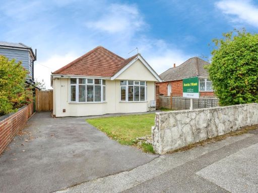 2 bedroom bungalow for sale in Upper Road, Poole, Dorset, BH12 — £340,000 • 2 bed • 1 bath • 643 ft²
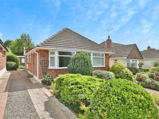 3 bedroom detached bungalow for sale in Astbury Avenue, Poole, BH12 — £325,000 • 3 bed • 1 bath • 614 ft²
 2 bedroom bungalow for sale in Rossmore Road, Parkstone, Poole, Dorset, BH12 — £332,000 • 2 bed • 1 bath • 680 ft²
 2 bedroom detached bungalow for sale in Heaton Road, Bournemouth, BH10 — £310,000 • 2 bed • 1 bath • 676 ft²
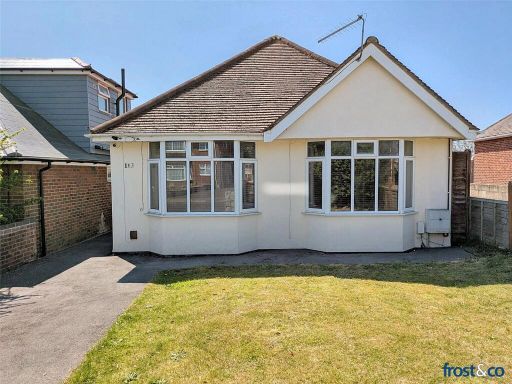 2 bedroom bungalow for sale in Upper Road, Branksome, Poole, Dorset, BH12 — £340,000 • 2 bed • 1 bath • 710 ft²
Meta
- {
"@context": "https://schema.org",
"@type": "Residence",
"name": "2 bedroom bungalow for sale in Gussage Road, Parkstone, Poo…",
"description": "",
"url": "https://propertypiper.co.uk/property/6c374b13-d74f-4687-ae3f-4869c10b76dc",
"image": "https://image-a.propertypiper.co.uk/043f0f48-458a-4b0d-b3fb-0fbf6ffa08fc-1024.jpeg",
"address": {
"@type": "PostalAddress",
"streetAddress": "3 GUSSAGE ROAD POOLE",
"postalCode": "BH12 4BZ",
"addressLocality": "Bournemouth, Christchurch and Poole",
"addressRegion": "Bournemouth West",
"addressCountry": "England"
},
"geo": {
"@type": "GeoCoordinates",
"latitude": 50.74308013377904,
"longitude": -1.9233873003556872
},
"numberOfRooms": 2,
"numberOfBathroomsTotal": 1,
"floorSize": {
"@type": "QuantitativeValue",
"value": 617,
"unitCode": "FTK"
},
"offers": {
"@type": "Offer",
"price": 294000,
"priceCurrency": "GBP",
"availability": "https://schema.org/InStock"
},
"additionalProperty": [
{
"@type": "PropertyValue",
"name": "Feature",
"value": "bungalow"
},
{
"@type": "PropertyValue",
"name": "Feature",
"value": "1960s"
},
{
"@type": "PropertyValue",
"name": "Feature",
"value": "single-story"
},
{
"@type": "PropertyValue",
"name": "Feature",
"value": "compact"
},
{
"@type": "PropertyValue",
"name": "Feature",
"value": "driveway"
},
{
"@type": "PropertyValue",
"name": "Feature",
"value": "low-maintenance"
},
{
"@type": "PropertyValue",
"name": "Feature",
"value": "suburban"
},
{
"@type": "PropertyValue",
"name": "Feature",
"value": "mid-20th century"
},
{
"@type": "PropertyValue",
"name": "Feature",
"value": "living room"
},
{
"@type": "PropertyValue",
"name": "Feature",
"value": "standard ceiling"
},
{
"@type": "PropertyValue",
"name": "Feature",
"value": "large window"
},
{
"@type": "PropertyValue",
"name": "Feature",
"value": "natural light"
},
{
"@type": "PropertyValue",
"name": "Feature",
"value": "suburban views"
}
]
}
High Res Floorplan Images
Compatible Floorplan Images
FloorplanImages Thumbnail