YO26 7AG - 4 bedroom detached house for sale in Southfield Lane, Tockw…
View on Property Piper
4 bedroom detached house for sale in Southfield Lane,
Tockwith,
YO26 7AG
, YO26
Property Details
- Price: £509950
- Bedrooms: 4
- Bathrooms: 3
- Property Type: undefined
- Property SubType: undefined
Brochure Descriptions
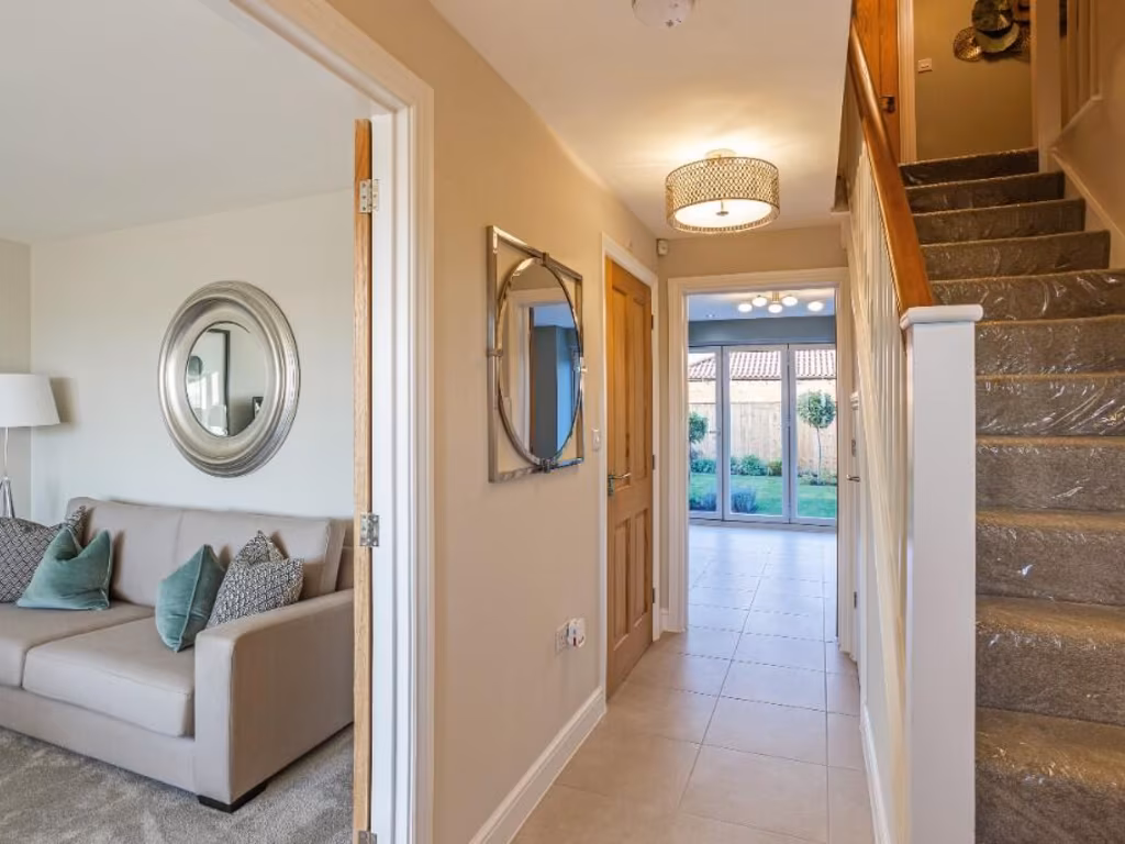
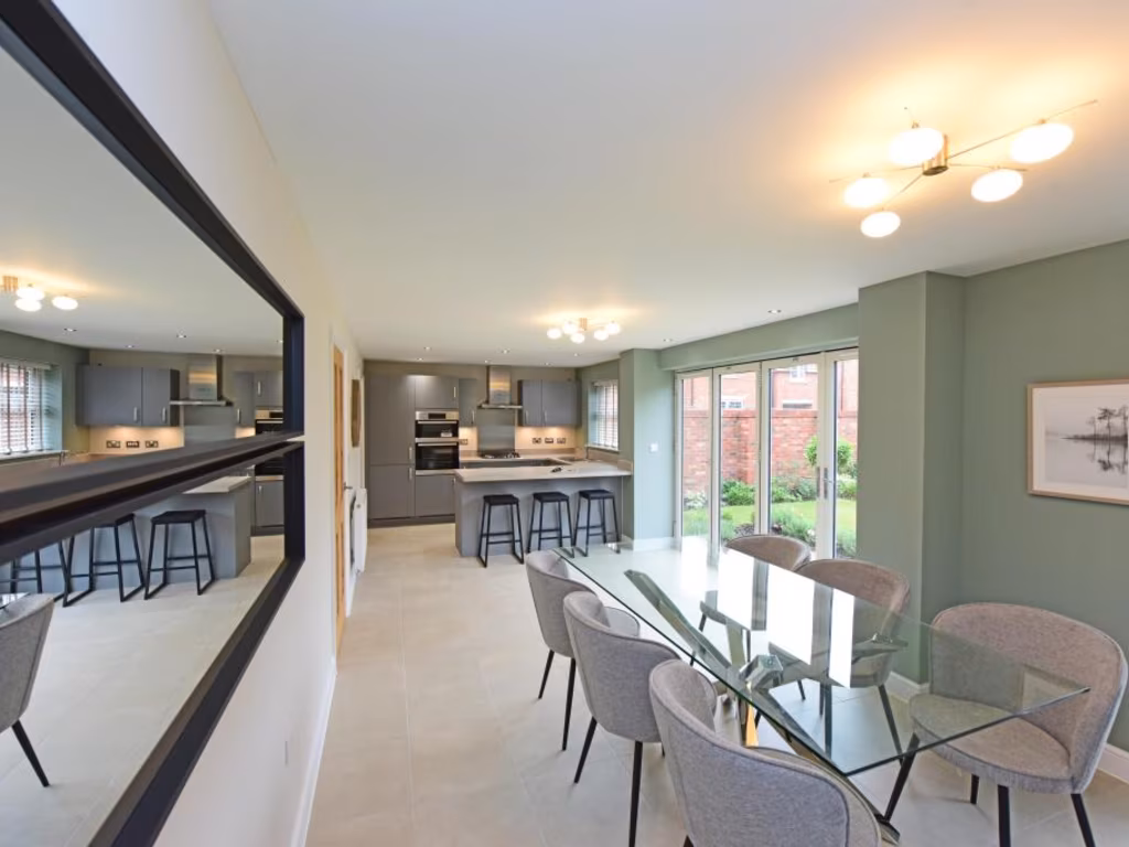
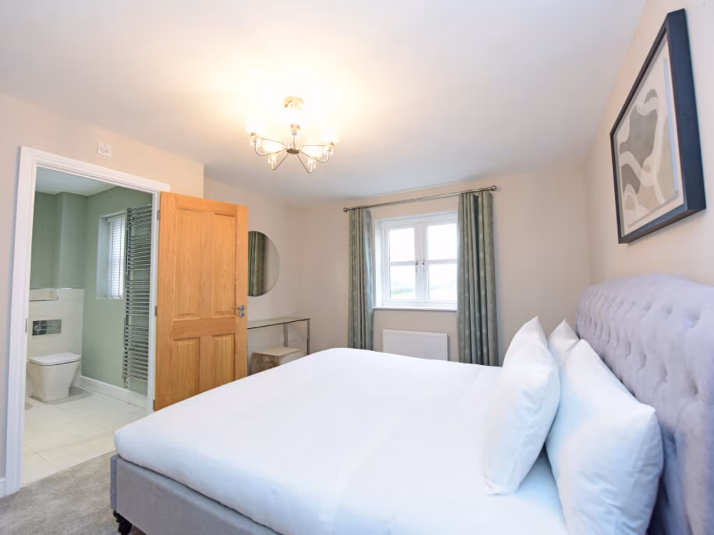
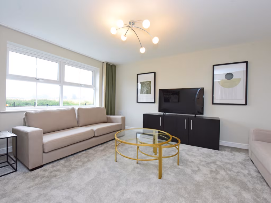
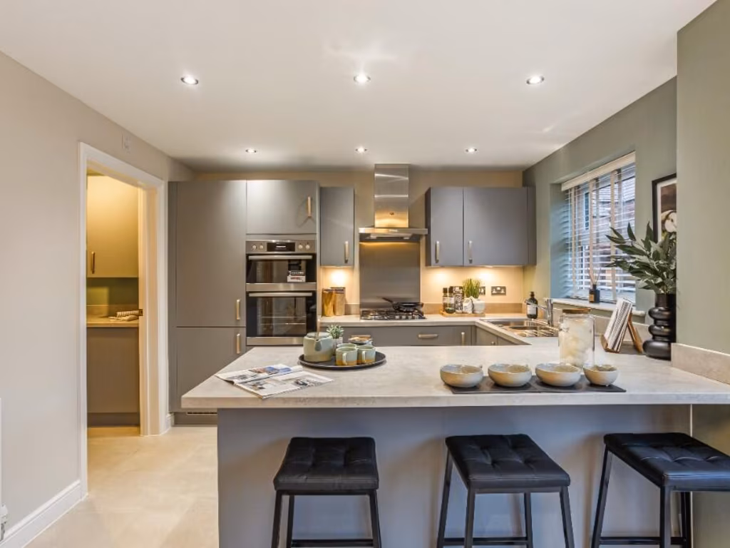
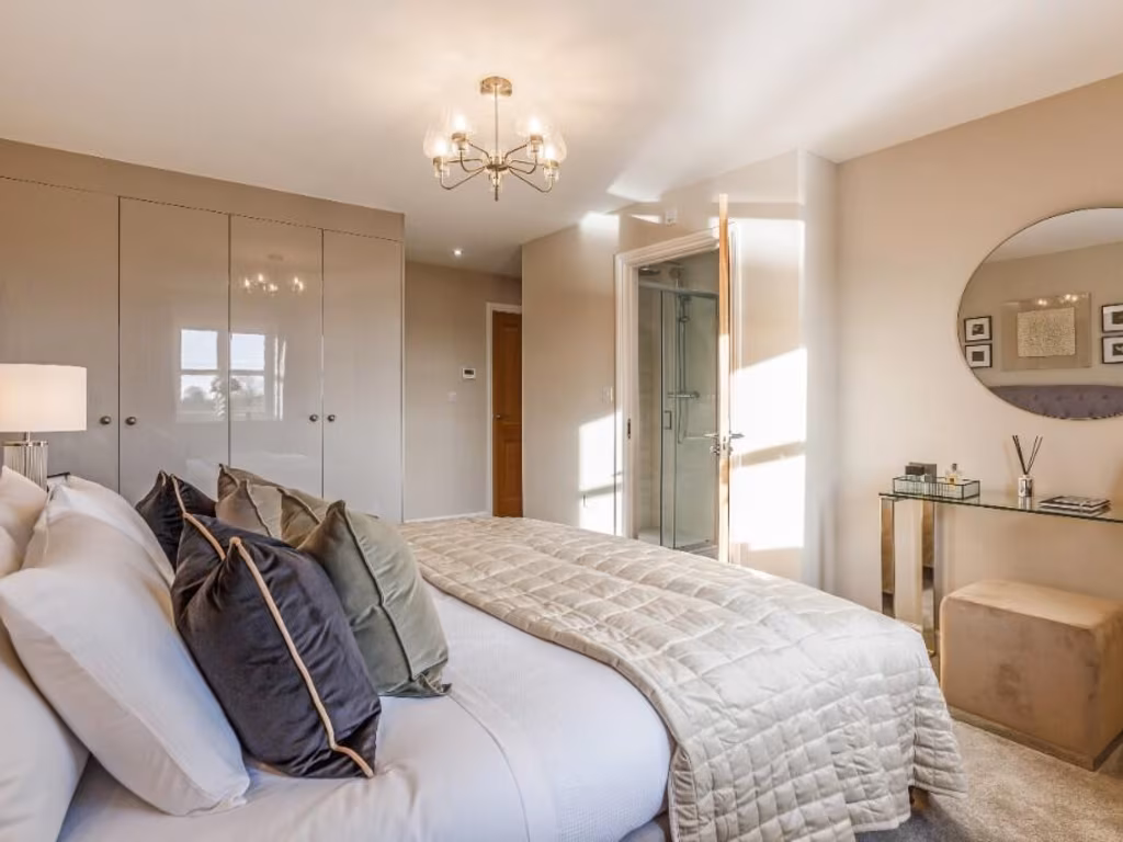
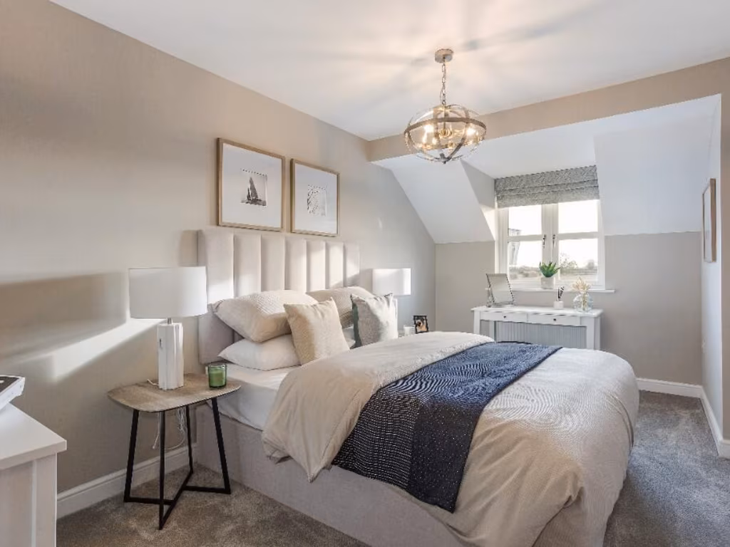
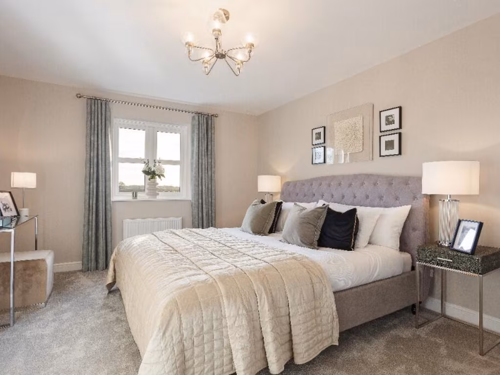
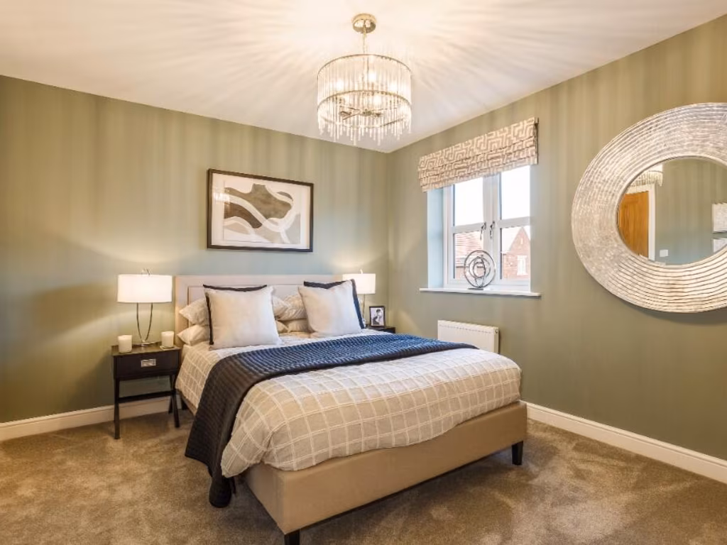
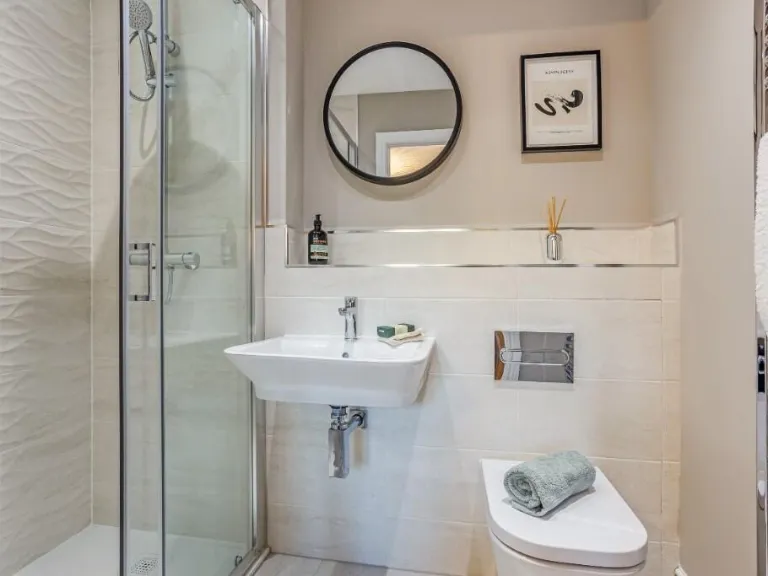
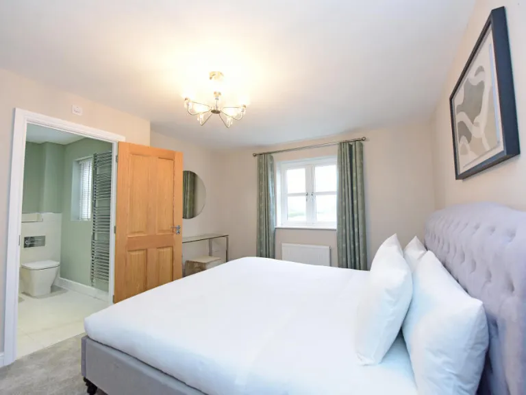
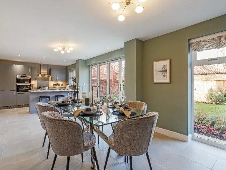
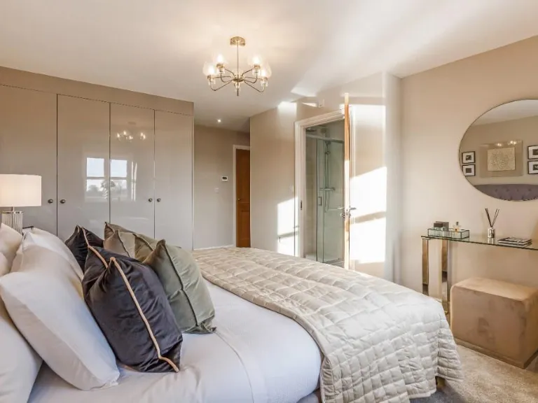
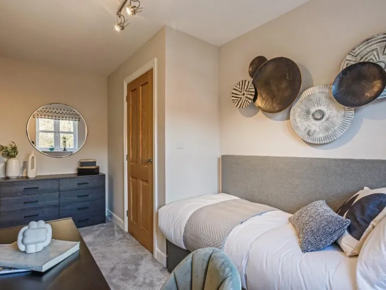
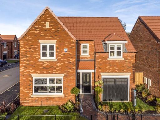
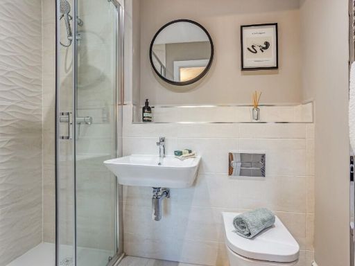
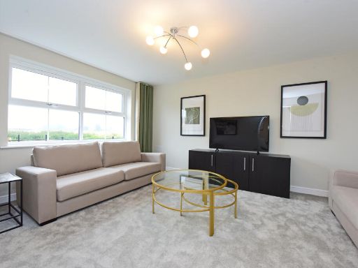
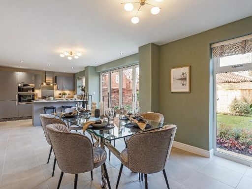
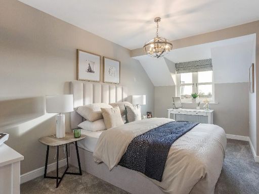
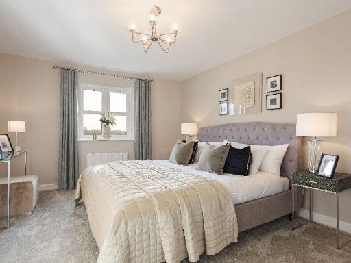
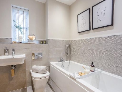
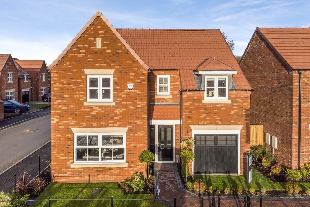
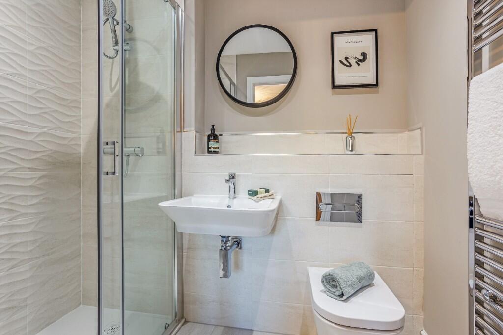
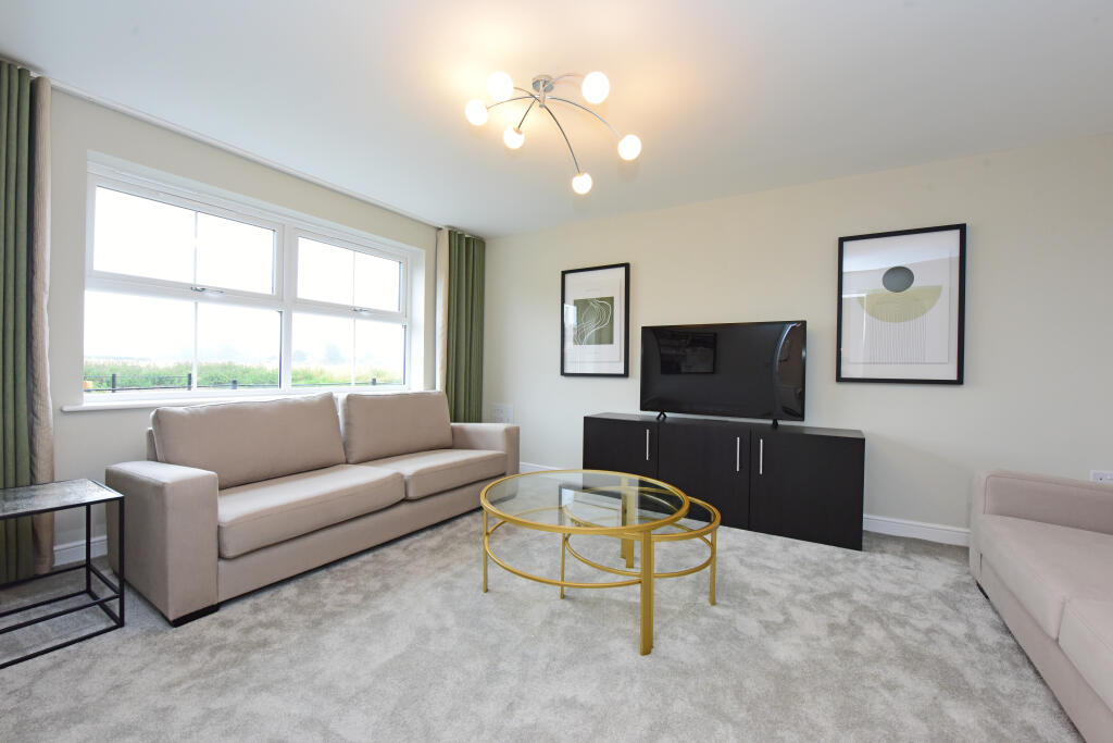
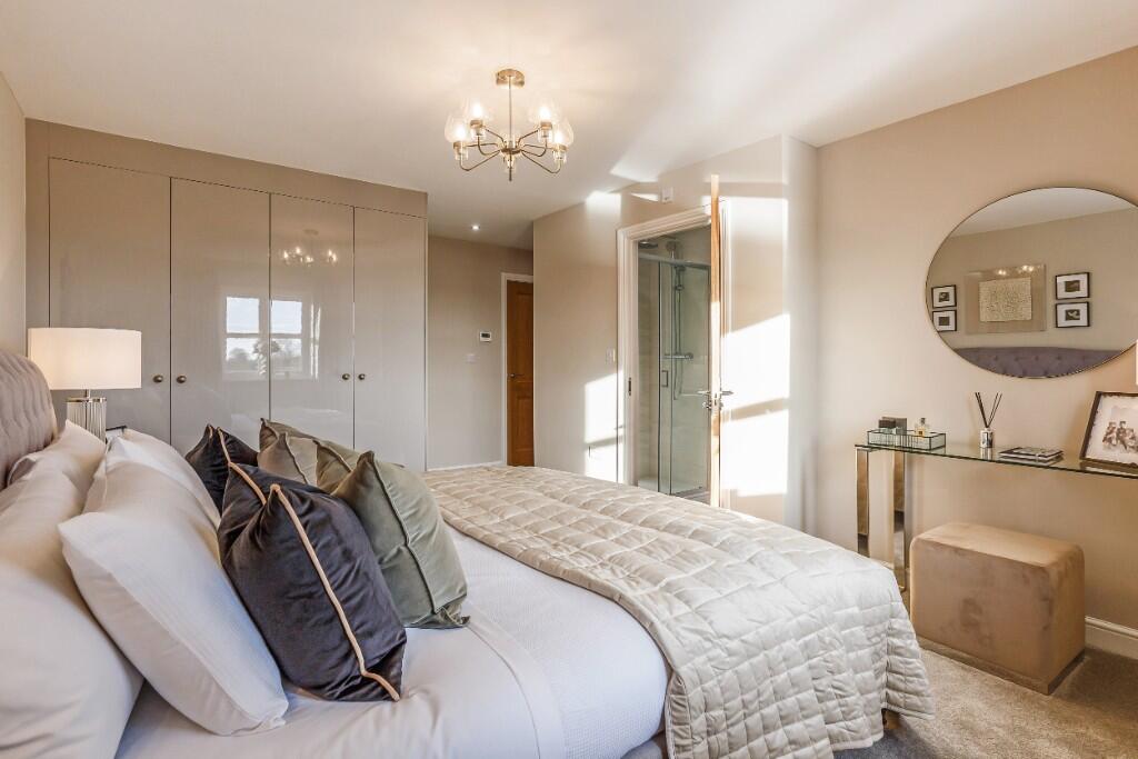
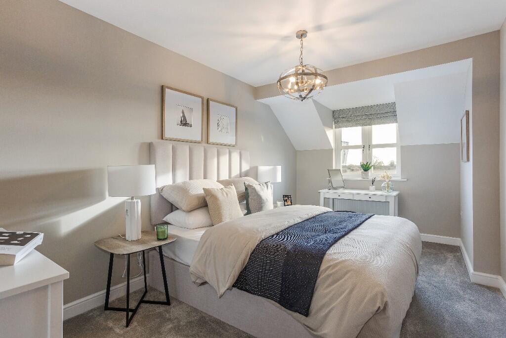
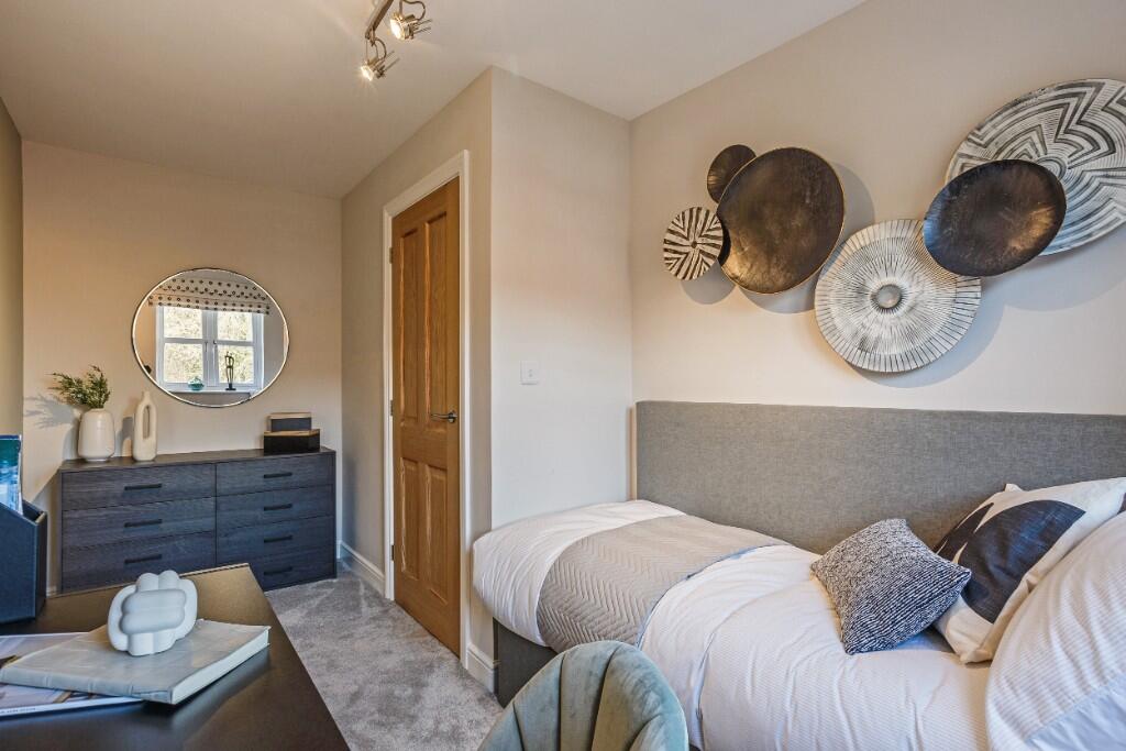
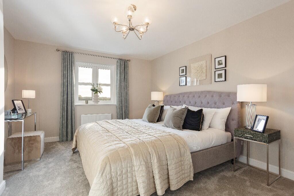
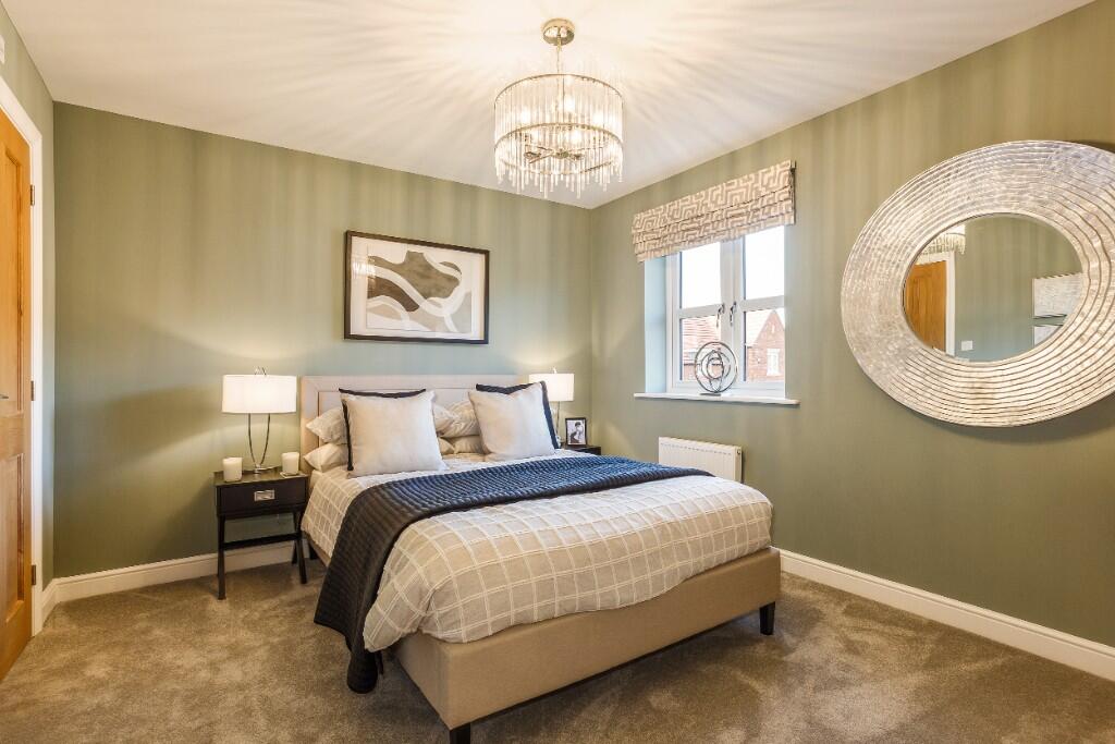
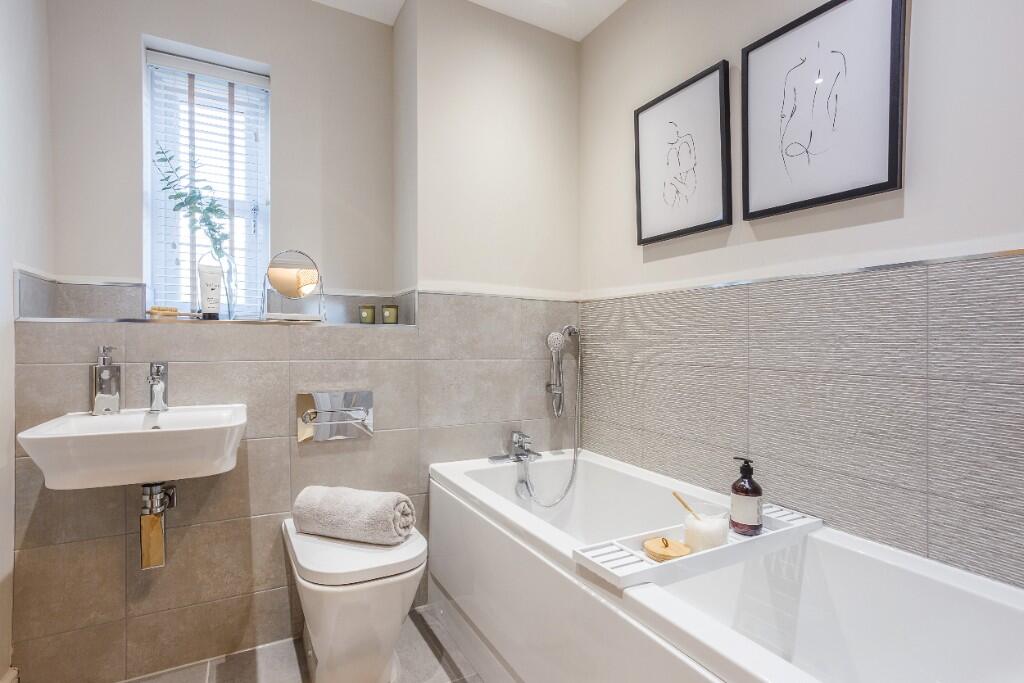
- The property appears to be located in a newly developed residential area known as Regency Place in Tockwith. The homes in this development offer stylish interiors and are crafted with a high standard of specification. The available image of the interior suggests an average-sized living room with modern design elements and ample natural lighting. The properties are likely designed for family living, with external images suggesting access to outdoor areas suitable for children. The development is marketed towards those seeking quality living environments in a desirable location.
- The property is likely located within a development named Regency Place in Tockwith. It potentially offers modern homes that might cater to both families and professionals. The surrounding area could likely include a suburban setting with well-maintained green spaces and possible community amenities. Without more detailed images, the exact features and size of the property remain unspecified.
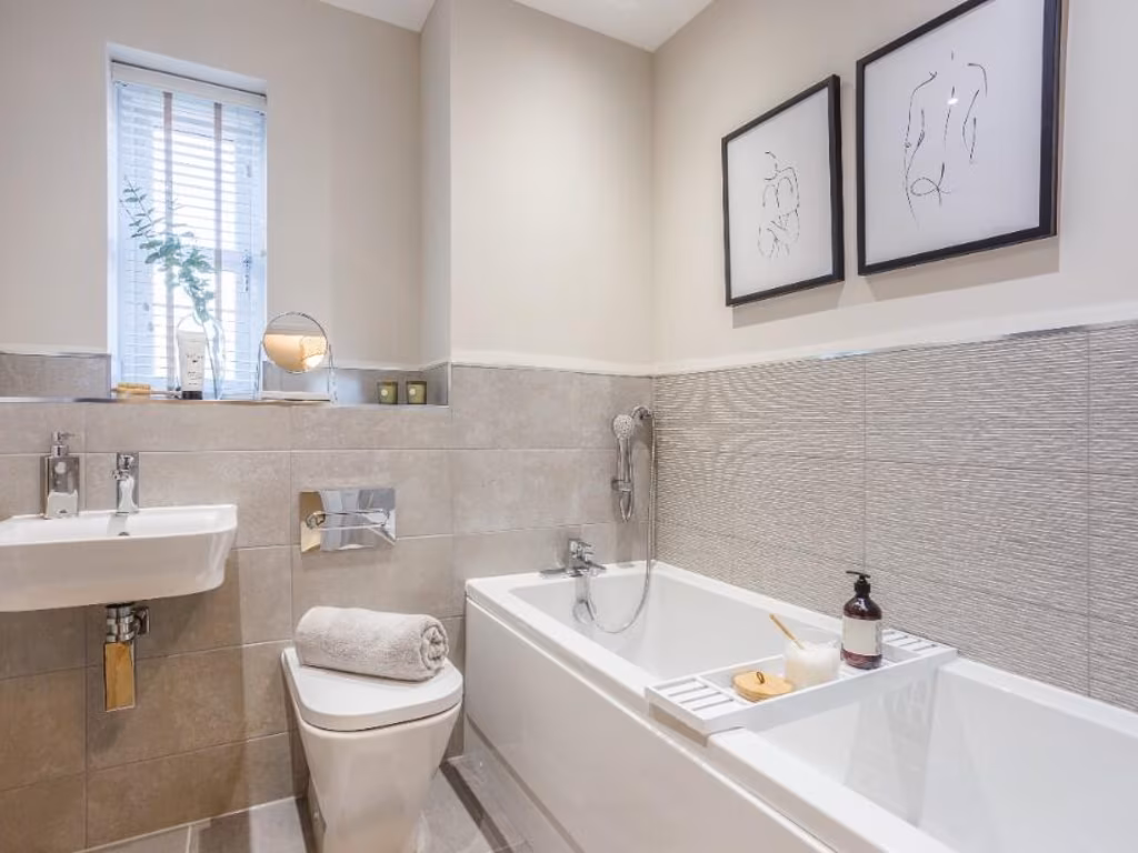
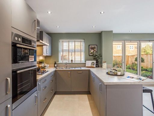
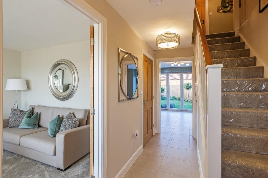
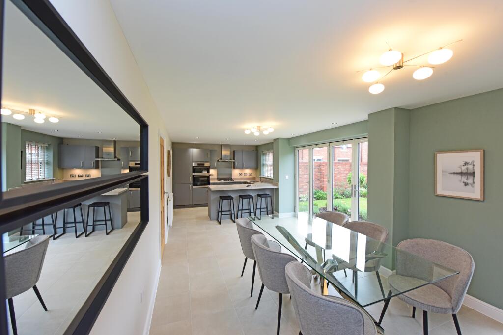
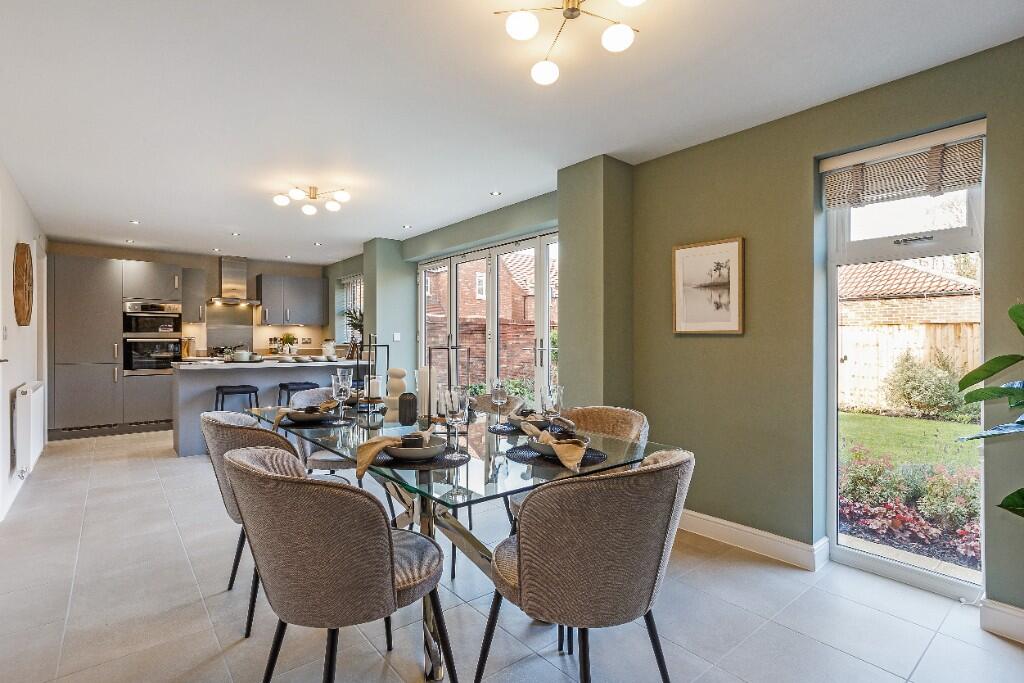
- The property is located in Regency Place, Tockwith, featuring a stylish and sophisticated design. This residential area provides a serene environment with beautiful exteriors and professionally landscaped gardens. The interior offers a large, open-plan living area with excellent lighting, reflecting a modern and spacious dwelling. It appears as a well-planned community thoughtfully designed for comfortable and upscale living, although individual room sizes are not explicitly depicted.
Image Descriptions
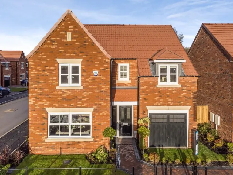
- modern detached family house Modern
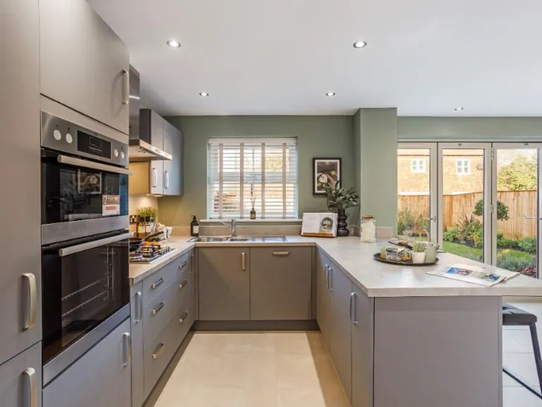
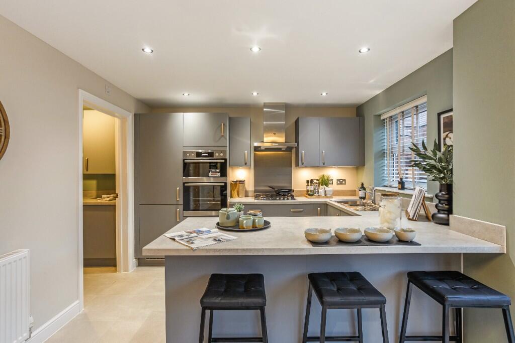
- kitchen modern
Floorplan Description
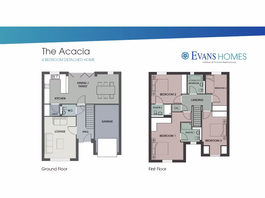
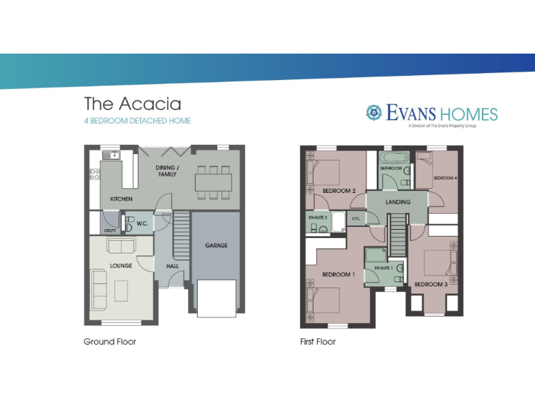
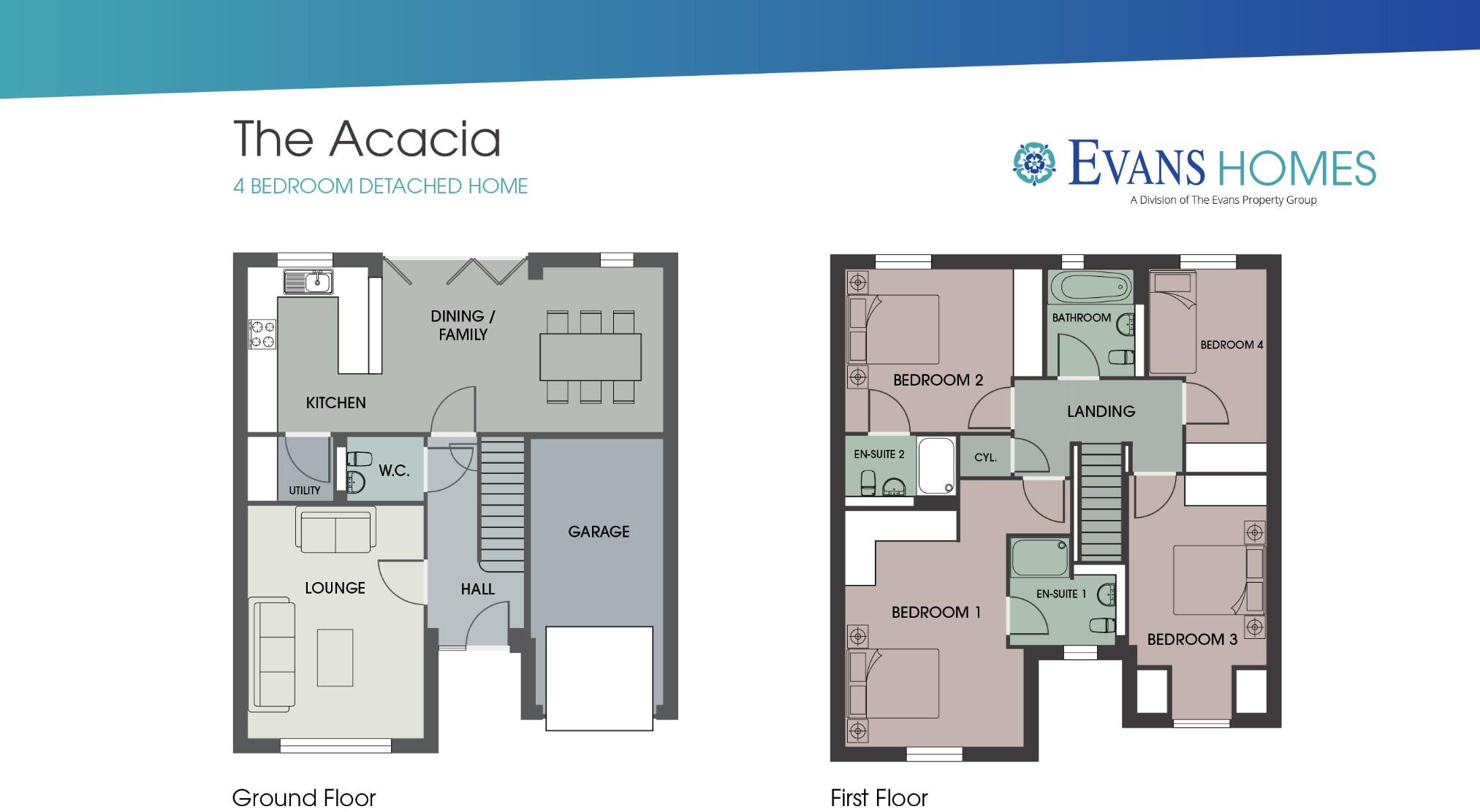
- 4 bedroom detached home with a ground and first floor.
Rooms
- Kitchen:
- Dining / Family:
- Lounge:
- Utility:
- W.C.:
- Hall:
- Garage:
- Bedroom 1:
- Bedroom 2:
- Bedroom 3:
- Bedroom 4:
Textual Property Features
Detected Visual Features
- modern
- detached
- family house
- double garage
- bay window
- garden
- driveway
- brick facade
- modern kitchen
- integrated appliances
- natural light
- neutral decor
- double oven
Nearby Schools
- Green Hammerton Church of England Primary School
- Riverside School, Tadcaster
- Tadcaster Primary Academy
- Bramham Primary School
- Lady Elizabeth Hastings' CofE VA Primary School, Thorp Arch
- Rufforth Primary School
- Tockwith Church of England Primary Academy
- Queen Ethelburga's College
- The Faculty of Queen Ethelburga's
- Boston Spa Academy
- Primrose Lane Primary School
- Wetherby High School
- St James' Church of England Voluntary Controlled Primary School
- Kirk Hammerton Church of England Primary School
- Nun Monkton Primary Foundation School
- St Edward's Catholic Primary School, Boston Spa
- Long Marston Church of England Voluntary Controlled Primary School
- St Mary's Church of England Controlled Primary School Boston Spa
- St Mary's Church of England Voluntary Controlled Primary School
Nearest General Shops
- Id: 6662822520
- Tags:
- Addr:
- City: Kirk Hammerton
- Postcode: YO26 8DH
- Street: York Road
- Description: Mirrors ans Table lamps
- Name: Geoffrey Benson and Son
- Shop: homewares
- TagsNormalized:
- Lat: 53.9990638
- Lon: -1.2817389
- FullGeoHash: gcx54y4xm744
- PartitionGeoHash: gcx5
- Images:
- FoodStandards: null
- Distance: 4191.3
,- Id: 6371140671
- Tags:
- Name: Get Ahead Hats
- Shop: hat
- Source: Sign on main road
- TagsNormalized:
- Lat: 53.9666541
- Lon: -1.2370163
- FullGeoHash: gcx55b74x3mz
- PartitionGeoHash: gcx5
- Images:
- FoodStandards: null
- Distance: 3600.7
,- Id: 422851860
- Tags:
- Name: Wighill Park Guns
- Shop: gun
- TagsNormalized:
- Lat: 53.933022
- Lon: -1.290671
- FullGeoHash: gcx4fdhnt5vz
- PartitionGeoHash: gcx4
- Images:
- FoodStandards: null
- Distance: 3200.8
}
Nearest Grocery shops
- Id: 1759067411
- Tags:
- Addr:
- City: Kirk Hammerton
- Postcode: YO26 8EQ
- Street: York Road
- Name: Co-operative
- Shop: convenience
- TagsNormalized:
- Lat: 53.9983038
- Lon: -1.2720863
- FullGeoHash: gcx55n1dyjrs
- PartitionGeoHash: gcx5
- Images:
- FoodStandards: null
- Distance: 4251.3
,- Id: 685131677
- Tags:
- Name: Marston Animal Supplies
- Shop: convenience
- TagsNormalized:
- Lat: 53.9534458
- Lon: -1.2367193
- FullGeoHash: gcx4gvgmw772
- PartitionGeoHash: gcx4
- Images:
- FoodStandards: null
- Distance: 3698.7
,- Id: 747162041
- Tags:
- Brand: Costcutter
- Brand:wikidata: Q5175072
- Contact:
- Website: https://store-locator.costcutter.co.uk/costcutter-a369350854b9
- Name: Costcutter
- Shop: convenience
- TagsNormalized:
- costcutter
- convenience
- shop
- Lat: 53.9653601
- Lon: -1.2877746
- FullGeoHash: gcx548n708m8
- PartitionGeoHash: gcx5
- Images:
- FoodStandards: null
- Distance: 462.4
}
Nearest Religious buildings
- Id: 176245347
- Tags:
- Amenity: place_of_worship
- Building: church
- Denomination: anglican
- Name: St John the Baptist
- Religion: christian
- Wikidata: Q7593757
- TagsNormalized:
- place of worship
- church
- anglican
- baptist
- christian
- Lat: 53.9937156
- Lon: -1.2918755
- FullGeoHash: gcx54t721n5g
- PartitionGeoHash: gcx5
- Images:
- FoodStandards: null
- Distance: 3548.5
,- Id: 387402753
- Tags:
- Amenity: place_of_worship
- Building: church
- Denomination: anglican
- Designation: 12c, romanesque
- Name: St Helen's
- Religion: christian
- Source: visit
- Wikidata: Q17538231
- TagsNormalized:
- place of worship
- church
- anglican
- christian
- Lat: 53.9473644
- Lon: -1.2761777
- FullGeoHash: gcx4fuydnvsg
- PartitionGeoHash: gcx4
- Images:
- FoodStandards: null
- Distance: 1890.8
,- Id: 188800709
- Tags:
- Amenity: place_of_worship
- Building: church
- Denomination: anglican
- Name: Church of the Epiphany
- Religion: christian
- Wikidata: Q26670301
- TagsNormalized:
- place of worship
- church
- anglican
- christian
- Lat: 53.9651279
- Lon: -1.2909322
- FullGeoHash: gcx5485cxhgp
- PartitionGeoHash: gcx5
- Images:
- FoodStandards: null
- Distance: 371.1
}
Nearest Medical buildings
- Id: 262069622
- Tags:
- Amenity: clinic
- Building: yes
- Healthcare: clinic
- Name: Wetherby Health Centre
- TagsNormalized:
- clinic
- health
- healthcare
- health centre
- Lat: 53.9283182
- Lon: -1.3809061
- FullGeoHash: gcx4b967nx1u
- PartitionGeoHash: gcx4
- Images:
- FoodStandards: null
- Distance: 6938.8
,- Id: 4397050320
- Tags:
- Amenity: veterinary
- Name: Parkhill Veterinary Surgery
- TagsNormalized:
- Lat: 53.9245454
- Lon: -1.3746015
- FullGeoHash: gcx4b8xj1ryf
- PartitionGeoHash: gcx4
- Images:
- FoodStandards: null
- Distance: 6840.2
,- Id: 4744103764
- Tags:
- Addr:
- City: Green Hammerton
- Postcode: YO26 8BN
- Street: York Road
- Amenity: doctors
- Name: Springbank Surgery
- TagsNormalized:
- Lat: 54.0031424
- Lon: -1.2977717
- FullGeoHash: gcx54qyzperk
- PartitionGeoHash: gcx5
- Images:
- FoodStandards: null
- Distance: 4615.2
,- Id: 741145957
- Tags:
- Addr:
- City: Tockwith
- Housenumber: 21
- Postcode: YO26 7PR
- Street: Marston Road
- Amenity: doctors
- Building: yes
- Name: Springbank Surgery Tockwith Branch
- Phone: +44 1423 330030
- Website: https://www.springbankhealth.co.uk/
- TagsNormalized:
- Lat: 53.9653987
- Lon: -1.2853853
- FullGeoHash: gcx54b050r7q
- PartitionGeoHash: gcx5
- Images:
- FoodStandards: null
- Distance: 562.6
}
Nearest Airports
- Id: 11519546
- Tags:
- Addr:
- City: Leeds
- Postcode: LS19 7TU
- Aerodrome: international
- Aerodrome:type: public
- Aeroway: aerodrome
- Iata: LBA
- Icao: EGNM
- Name: Leeds Bradford Airport
- Operator: Leeds Bradford Airport Limited
- Operator:type: private
- Ref: LBA
- Type: multipolygon
- Website: https://www.leedsbradfordairport.co.uk/
- Wikidata: Q8699
- Wikipedia: en:Leeds Bradford Airport
- TagsNormalized:
- airport
- international airport
- Lat: 53.8667047
- Lon: -1.660138
- FullGeoHash: gcwf6nph7cx3
- PartitionGeoHash: gcwf
- Images:
- Q8699-1
- Q8699-2
- Q8699-3
- Q8699-4
- FoodStandards: null
- Distance: 26361.2
}
Nearest Leisure Facilities
- Id: 324013060
- Tags:
- Leisure: park
- Name: The Green
- TagsNormalized:
- Lat: 53.9655343
- Lon: -1.2942357
- FullGeoHash: gcx5481s40ez
- PartitionGeoHash: gcx5
- Images:
- FoodStandards: null
- Distance: 453.3
,- Id: 324013049
- Tags:
- Leisure: pitch
- Sport: tennis
- TagsNormalized:
- Lat: 53.9616896
- Lon: -1.2868059
- FullGeoHash: gcx4fxqvxhpb
- PartitionGeoHash: gcx4
- Images:
- FoodStandards: null
- Distance: 303.4
,- Id: 324013062
- Tags:
- Leisure: pitch
- Sport: bowls
- TagsNormalized:
- Lat: 53.9619993
- Lon: -1.2870823
- FullGeoHash: gcx4fxqz2vcb
- PartitionGeoHash: gcx4
- Images:
- FoodStandards: null
- Distance: 285.8
,- Id: 324013057
- Tags:
- Leisure: park
- Name: Lucas Drive Park
- TagsNormalized:
- Lat: 53.9637401
- Lon: -1.2932559
- FullGeoHash: gcx4fxf38fq8
- PartitionGeoHash: gcx4
- Images:
- FoodStandards: null
- Distance: 245.9
,- Id: 671328687
- Tags:
- Leisure: park
- Name: Lucas Drive Park
- TagsNormalized:
- Lat: 53.9636471
- Lon: -1.2931286
- FullGeoHash: gcx4fxf35bvm
- PartitionGeoHash: gcx4
- Images:
- FoodStandards: null
- Distance: 232.8
}
Nearest Tourist attractions
- Id: 4860603832
- Tags:
- Addr:
- City: Hessay
- Postcode: YO26 8JU
- Name: The Willows
- Tourism: guest_house
- TagsNormalized:
- Lat: 53.9786481
- Lon: -1.1869713
- FullGeoHash: gcx5hfx8mt64
- PartitionGeoHash: gcx5
- Images:
- FoodStandards: null
- Distance: 7084.8
,- Id: 27475931
- Tags:
- Addr:
- City: Wetherby
- Housenumber: 60
- Postcode: LS22 6NR
- Street: North Street
- Amenity: pub
- Fhrs:
- Guest_house: bed_and_breakfast
- Name: The Royal Oak
- Source:
- Tourism: guest_house
- Website: www.theroyaloakwetherby.co.uk
- TagsNormalized:
- Lat: 53.9308259
- Lon: -1.3843302
- FullGeoHash: gcx4b3zcyf8e
- PartitionGeoHash: gcx4
- Images:
- FoodStandards:
- Id: 702414
- FHRSID: 702414
- LocalAuthorityBusinessID: 14/00160/COMM
- BusinessName: The Royal Oak
- BusinessType: Pub/bar/nightclub
- BusinessTypeID: 7843
- AddressLine1: 60 North Street
- AddressLine2: Wetherby
- AddressLine3: null
- AddressLine4: null
- PostCode: LS22 6NR
- RatingValue: 5
- RatingKey: fhrs_5_en-GB
- RatingDate: 2019-06-13
- LocalAuthorityCode: 413
- LocalAuthorityName: Leeds
- LocalAuthorityWebSite: http://www.leeds.gov.uk/
- LocalAuthorityEmailAddress: food.safety@leeds.gov.uk
- Scores:
- Hygiene: 0
- Structural: 0
- ConfidenceInManagement: 0
- NewRatingPending: false
- Geocode:
- Longitude: -1.38432100000000
- Latitude: 53.93084000000000
- Distance: 6987.2
,- Id: 4906718421
- Tags:
- Name: Tockwith Caravan Storage
- Tourism: caravan_site
- TagsNormalized:
- Lat: 53.9654709
- Lon: -1.3103757
- FullGeoHash: gcx540jgdhcj
- PartitionGeoHash: gcx5
- Images:
- FoodStandards: null
- Distance: 1304.1
}
Nearest Bus stations and stops
- Id: 496722037
- Tags:
- Bus: yes
- Highway: bus_stop
- Local_ref: 45014495
- Name: Walton Corner Walton
- Naptan:
- AtcoCode: 450014495
- Bearing: E
- CommonName: Walton Corner Walton
- Indicator: Stop 45014495
- PlusbusZoneRef: LEEDS
- ShortCommonName: Walton Corner
- Street: Wetherby Road
- Verified: no
- Public_transport: platform
- Source: naptan_import
- TagsNormalized:
- Lat: 53.922407
- Lon: -1.330694
- FullGeoHash: gcx4c8r0b94w
- PartitionGeoHash: gcx4
- Images:
- FoodStandards: null
- Distance: 5078.6
,- Id: 6286866109
- Tags:
- Bus: yes
- Highway: bus_stop
- Name: 006s School Bus
- Public_transport: platform
- Surface: paved
- TagsNormalized:
- Lat: 53.953864
- Lon: -1.2371361
- FullGeoHash: gcx4gy50h9hr
- PartitionGeoHash: gcx4
- Images:
- FoodStandards: null
- Distance: 3660.8
,- Id: 4574219867
- Tags:
- Bus: yes
- Highway: bus_stop
- Public_transport: platform
- TagsNormalized:
- Lat: 53.9496192
- Lon: -1.314347
- FullGeoHash: gcx4fj4zm3zy
- PartitionGeoHash: gcx4
- Images:
- FoodStandards: null
- Distance: 2020.5
,- Id: 6286866116
- Tags:
- Bus: yes
- Highway: bus_stop
- Public_transport: platform
- TagsNormalized:
- Lat: 53.9689291
- Lon: -1.2945554
- FullGeoHash: gcx5489rf9td
- PartitionGeoHash: gcx5
- Images:
- FoodStandards: null
- Distance: 818
,- Id: 6289615263
- Tags:
- Bus: yes
- Highway: bus_stop
- Public_transport: platform
- TagsNormalized:
- Lat: 53.9657407
- Lon: -1.2909077
- FullGeoHash: gcx5485vpxjq
- PartitionGeoHash: gcx5
- Images:
- FoodStandards: null
- Distance: 439.1
}
Nearest Hotels
- Id: 262069680
- Tags:
- Addr:
- Postcode: LS22 5HE
- Street: Leeds Road
- Town: Wetherby
- Fhrs:
- Name: Mercure Wetherby Hotel
- Source: Bing
- Tourism: hotel
- TagsNormalized:
- Lat: 53.9245363
- Lon: -1.3874233
- FullGeoHash: gcx4b2ttnwnh
- PartitionGeoHash: gcx4
- Images:
- FoodStandards: null
- Distance: 7525.7
,- Id: 633012581
- Tags:
- Addr:
- Amenity: pub
- Building: commercial
- Name: The Crown Hotel
- TagsNormalized:
- Lat: 53.9055781
- Lon: -1.3491107
- FullGeoHash: gcx49m1wg2n4
- PartitionGeoHash: gcx4
- Images:
- FoodStandards: null
- Distance: 7303.5
,- Id: 752987727
- Tags:
- Brand: Days Inn
- Brand:wikidata: Q1047239
- Name: Days Inn
- Operator: Welcome Break
- Tourism: hotel
- TagsNormalized:
- Lat: 53.9476827
- Lon: -1.3691994
- FullGeoHash: gcx4bufup2fy
- PartitionGeoHash: gcx4
- Images:
- FoodStandards: null
- Distance: 5324.6
}
Tags
- modern
- detached
- family house
- double garage
- bay window
- garden
- driveway
- brick facade
- modern kitchen
- integrated appliances
- natural light
- neutral decor
- double oven
Local Market Stats
- Average Price/sqft: £313
- Avg Income: £47000
- Rental Yield: 3.8%
- Social Housing: 7%
- Planning Success Rate: 89%
Similar Properties
 4 bedroom detached house for sale in Southfield Lane,
Tockwith,
YO26 7AG
, YO26 — £499,950 • 4 bed • 3 bath
4 bedroom detached house for sale in Southfield Lane,
Tockwith,
YO26 7AG
, YO26 — £499,950 • 4 bed • 3 bath 4 bedroom detached house for sale in Southfield Lane,
Tockwith,
YO26 7AG
, YO26 — £499,950 • 4 bed • 3 bath
4 bedroom detached house for sale in Southfield Lane,
Tockwith,
YO26 7AG
, YO26 — £499,950 • 4 bed • 3 bath 4 bedroom detached house for sale in Southfield Lane,
Tockwith,
YO26 7AG
, YO26 — £495,000 • 4 bed • 3 bath
4 bedroom detached house for sale in Southfield Lane,
Tockwith,
YO26 7AG
, YO26 — £495,000 • 4 bed • 3 bath 4 bedroom detached house for sale in Southfield Lane,
Tockwith,
YO26 7AG
, YO26 — £495,950 • 4 bed • 3 bath
4 bedroom detached house for sale in Southfield Lane,
Tockwith,
YO26 7AG
, YO26 — £495,950 • 4 bed • 3 bath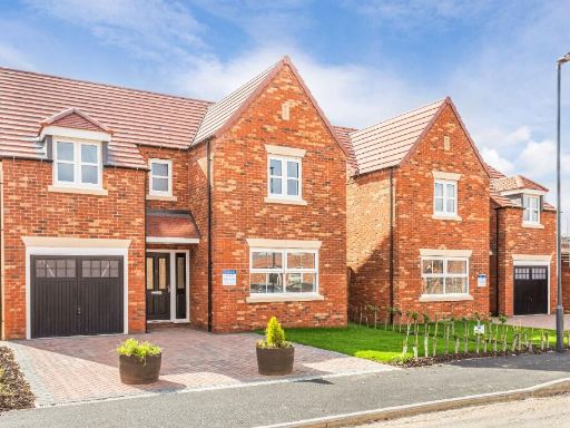 4 bedroom detached house for sale in Southfield Lane,
Tockwith,
YO26 7AG
, YO26 — £470,000 • 4 bed • 3 bath
4 bedroom detached house for sale in Southfield Lane,
Tockwith,
YO26 7AG
, YO26 — £470,000 • 4 bed • 3 bath 4 bedroom detached house for sale in Southfield Lane,
Tockwith,
YO26 7AG
, YO26 — £499,950 • 4 bed • 3 bath
4 bedroom detached house for sale in Southfield Lane,
Tockwith,
YO26 7AG
, YO26 — £499,950 • 4 bed • 3 bath
Meta
- {
"@context": "https://schema.org",
"@type": "Residence",
"name": "4 bedroom detached house for sale in Southfield Lane, Tockw…",
"description": "",
"url": "https://propertypiper.co.uk/property/69dda4d1-7146-49c5-b5b5-4fb21593ab11",
"image": "https://image-a.propertypiper.co.uk/bd726fc5-62fd-4518-a720-8bfa1d6e8dab-1024.jpeg",
"address": {
"@type": "PostalAddress",
"streetAddress": "Southfield Lane, \r\nTockwith, \r\nYO26 7AG\r\n",
"postalCode": "YO26 7AG",
"addressLocality": "Harrogate",
"addressRegion": "Selby and Ainsty",
"addressCountry": "England"
},
"geo": {
"@type": "GeoCoordinates",
"latitude": 53.961804307517305,
"longitude": -1.291439080255205
},
"numberOfRooms": 4,
"numberOfBathroomsTotal": 3,
"offers": {
"@type": "Offer",
"price": 509950,
"priceCurrency": "GBP",
"availability": "https://schema.org/InStock"
},
"additionalProperty": [
{
"@type": "PropertyValue",
"name": "Feature",
"value": "modern"
},
{
"@type": "PropertyValue",
"name": "Feature",
"value": "detached"
},
{
"@type": "PropertyValue",
"name": "Feature",
"value": "family house"
},
{
"@type": "PropertyValue",
"name": "Feature",
"value": "double garage"
},
{
"@type": "PropertyValue",
"name": "Feature",
"value": "bay window"
},
{
"@type": "PropertyValue",
"name": "Feature",
"value": "garden"
},
{
"@type": "PropertyValue",
"name": "Feature",
"value": "driveway"
},
{
"@type": "PropertyValue",
"name": "Feature",
"value": "brick facade"
},
{
"@type": "PropertyValue",
"name": "Feature",
"value": "modern kitchen"
},
{
"@type": "PropertyValue",
"name": "Feature",
"value": "integrated appliances"
},
{
"@type": "PropertyValue",
"name": "Feature",
"value": "natural light"
},
{
"@type": "PropertyValue",
"name": "Feature",
"value": "neutral decor"
},
{
"@type": "PropertyValue",
"name": "Feature",
"value": "double oven"
}
]
}
High Res Floorplan Images
Compatible Floorplan Images
FloorplanImages Thumbnail