ST13 5RQ - 3 bedroom detached house for sale in Birchall Close, Bircha…
View on Property Piper
3 bedroom detached house for sale in Birchall Close, Birchall, Leek, Staffordshire, ST13
Property Details
- Price: £495000
- Bedrooms: 3
- Bathrooms: 1
- Property Type: undefined
- Property SubType: undefined
Brochure Descriptions
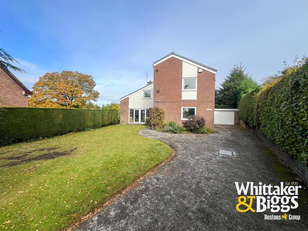
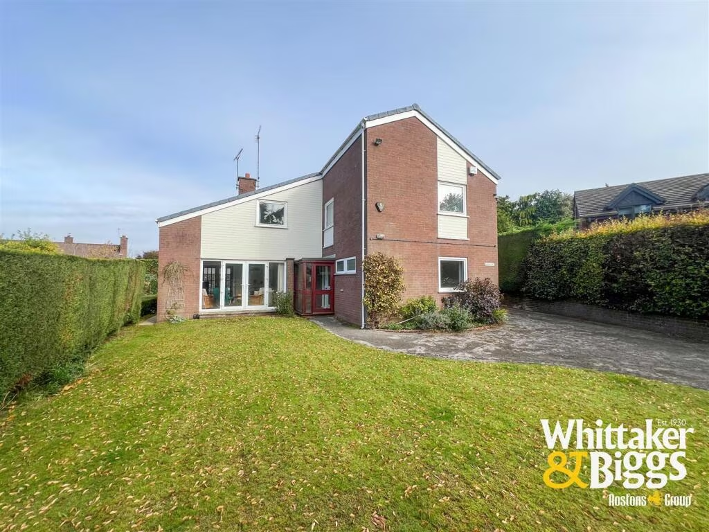
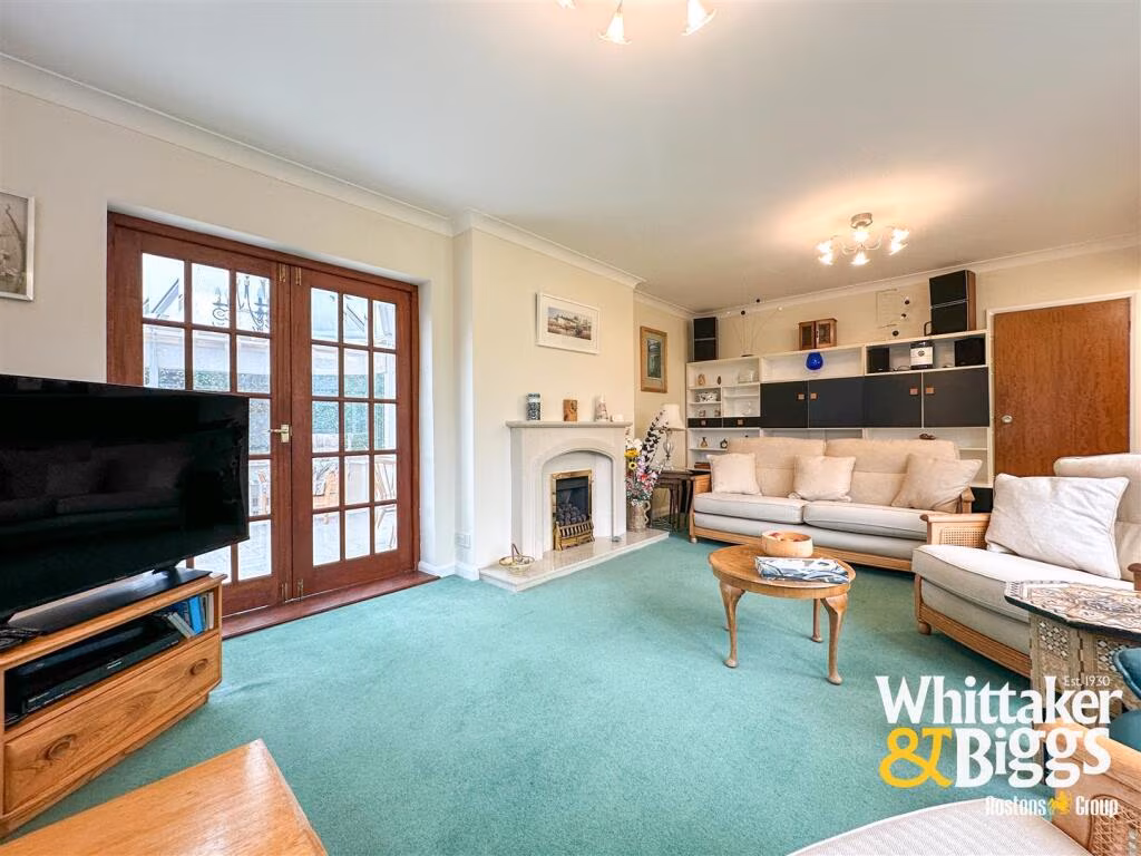
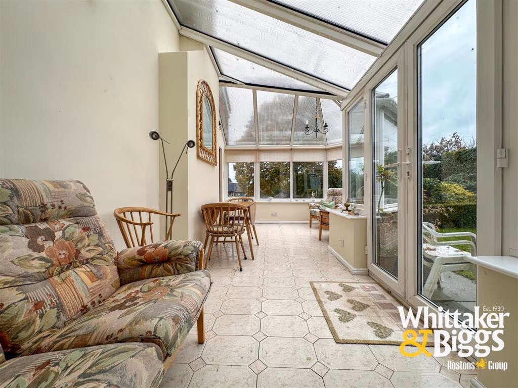
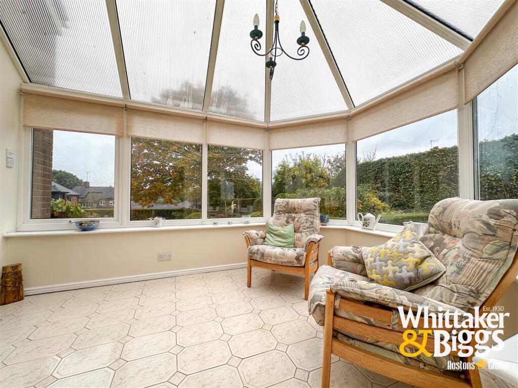
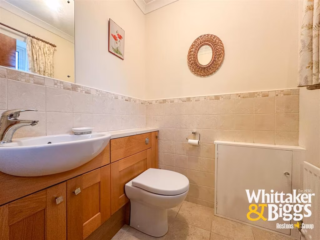
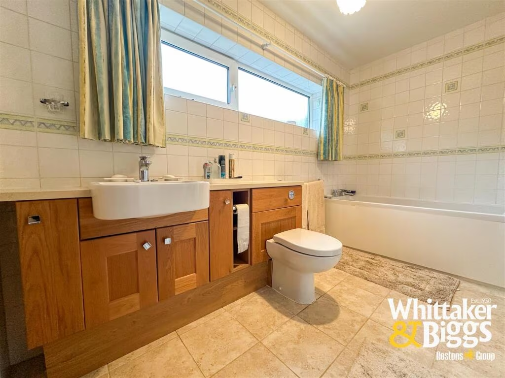
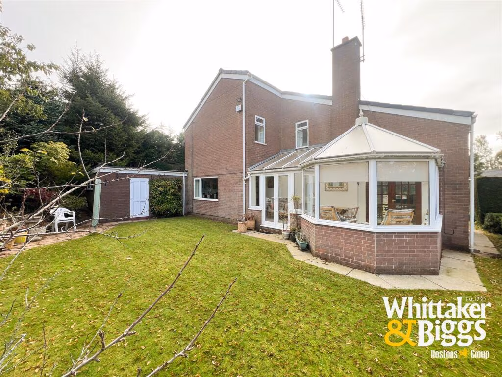
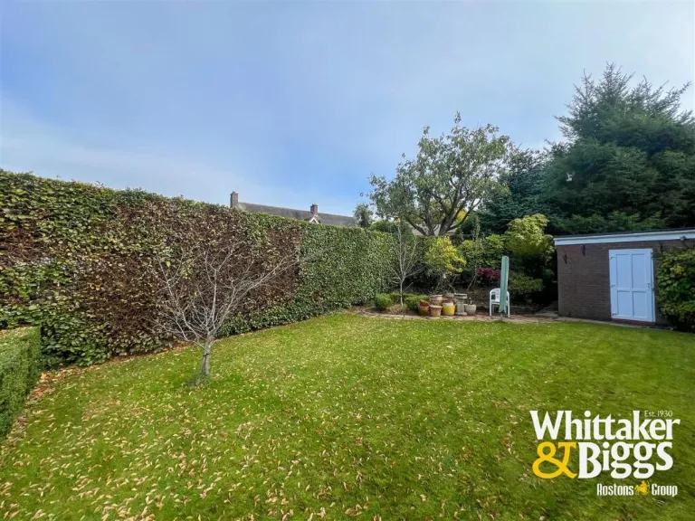
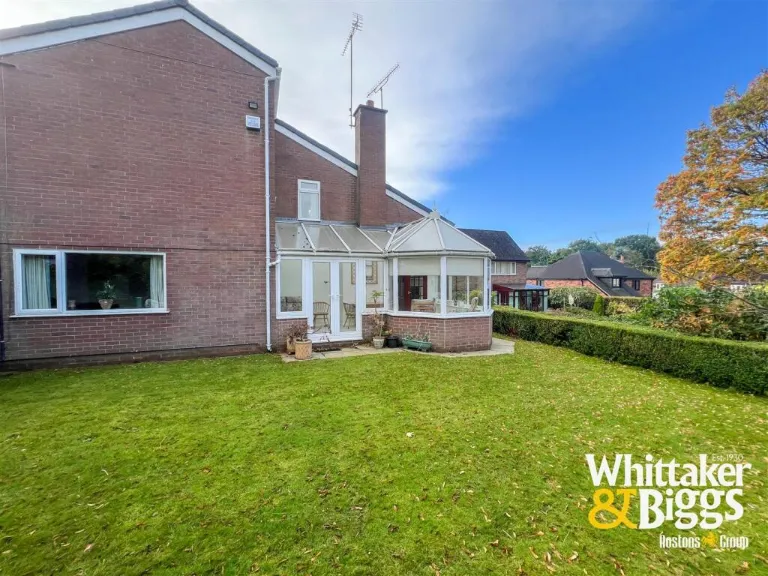
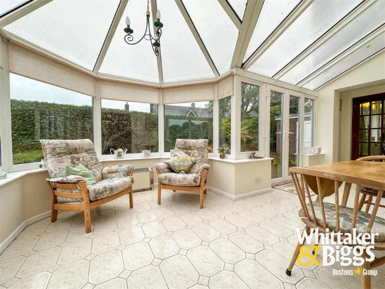
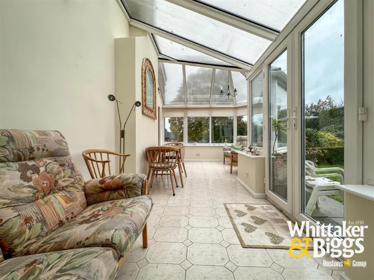
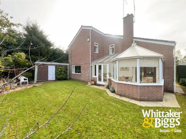
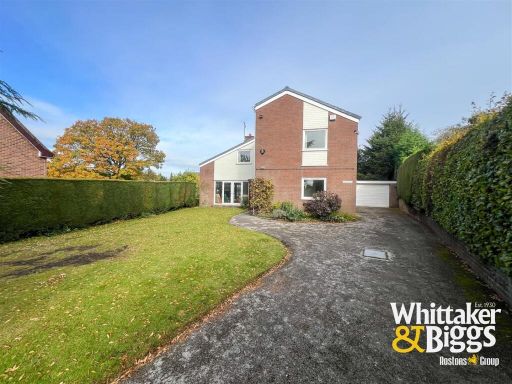
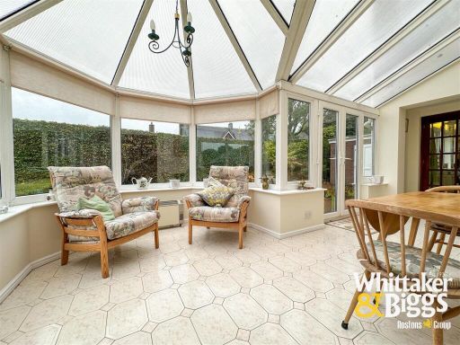
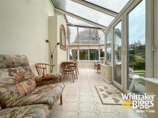
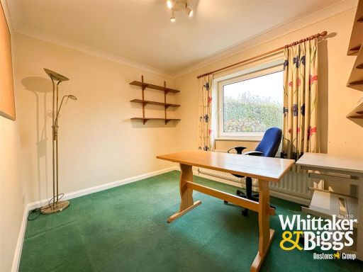
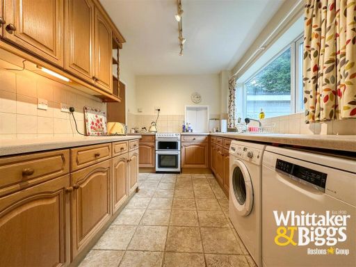
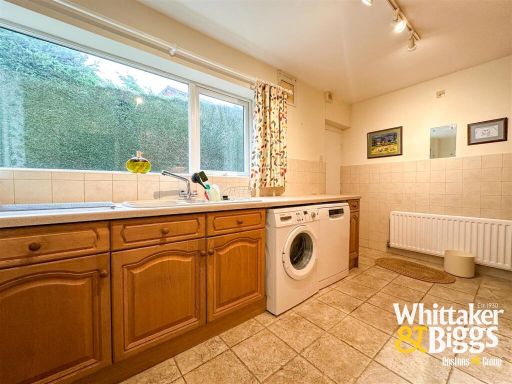
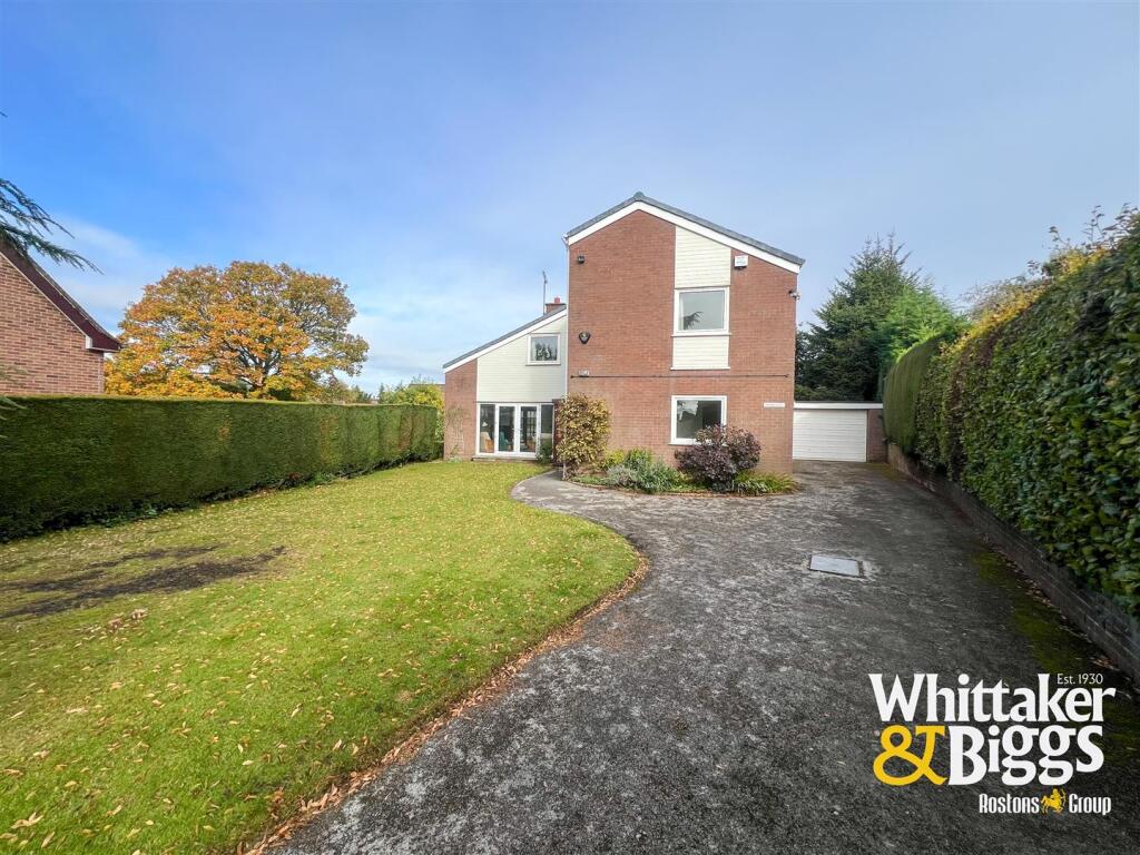
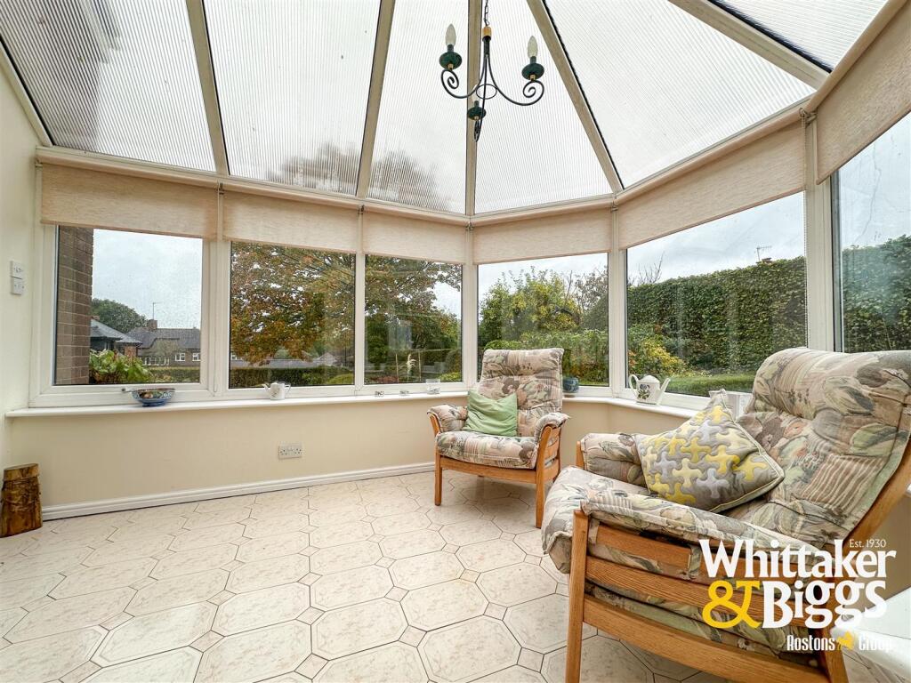
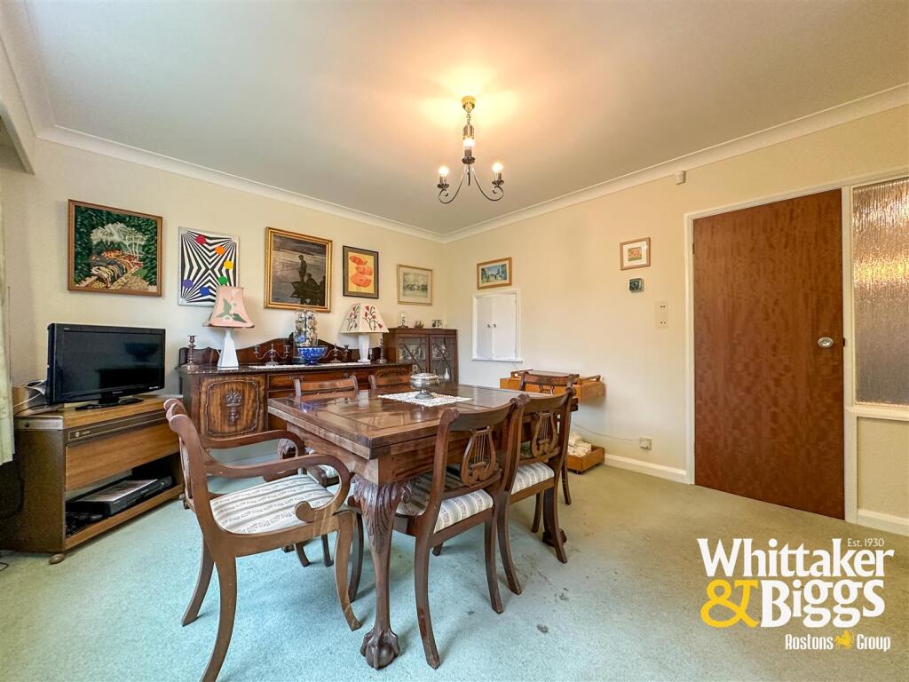
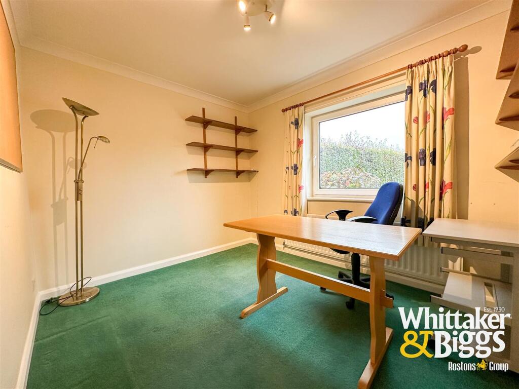
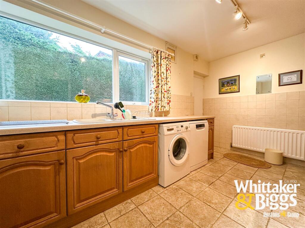
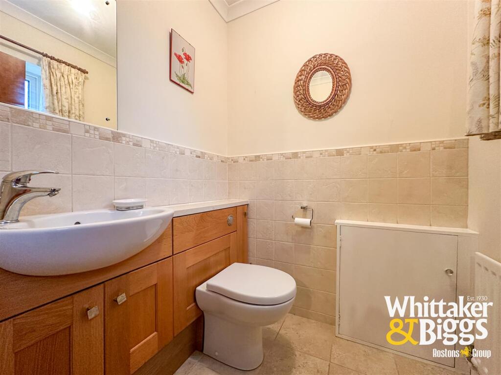
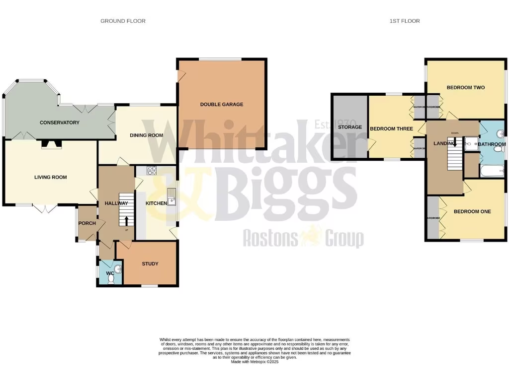
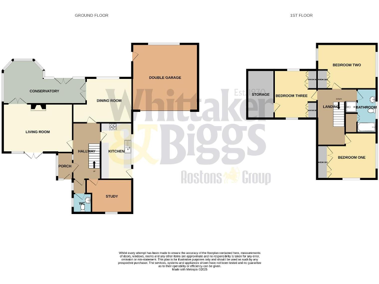
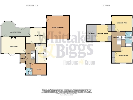
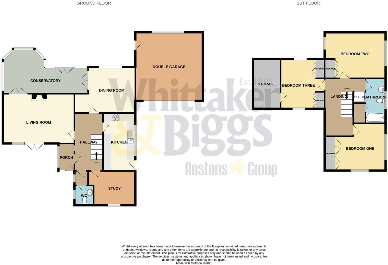
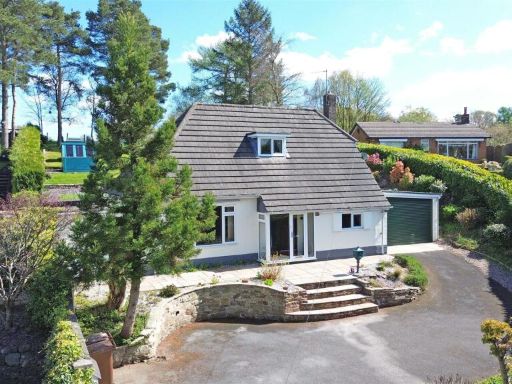
- Detached three-bedroom family home presented on a substantial plot within a cul-de-sac. The property has a long driveway providing parking to the front and side and leads to a double garage with electric door. Gardens to the front and rear are large and private, enclosed by high hedging. The house appears to include a substantial conservatory to the rear, a well-equipped kitchen and bathroom, a study and a ground-floor WC. Overall plot size is large; the dwelling itself is medium–large for a suburban detached house and sits in a quiet residential setting.
Image Descriptions
- detached house mid-century modern
- house and garden mid-century modern
Rooms
- CONSERVATORY:
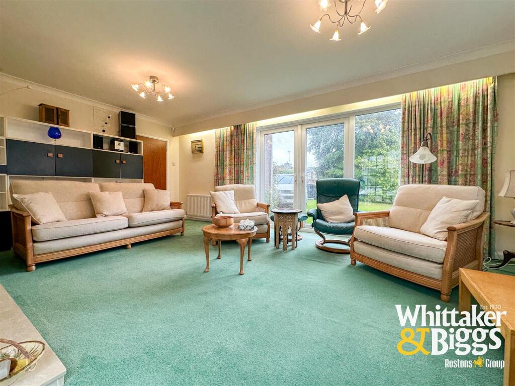
- LIVING ROOM:
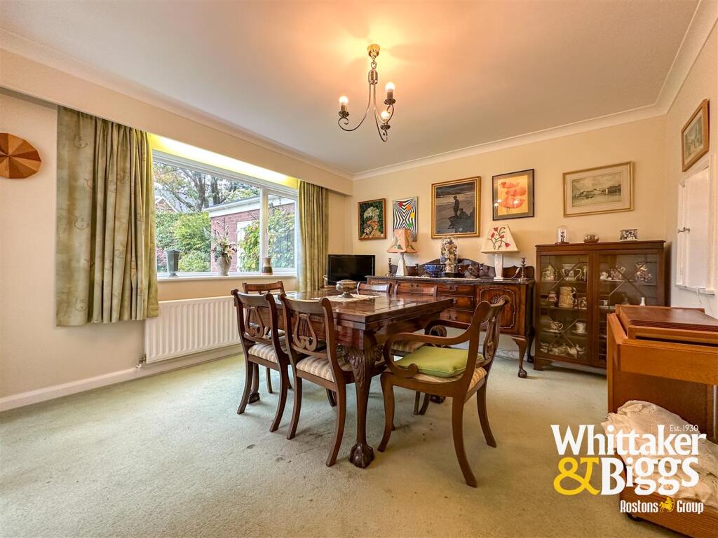
- DINING ROOM:
- DOUBLE GARAGE:
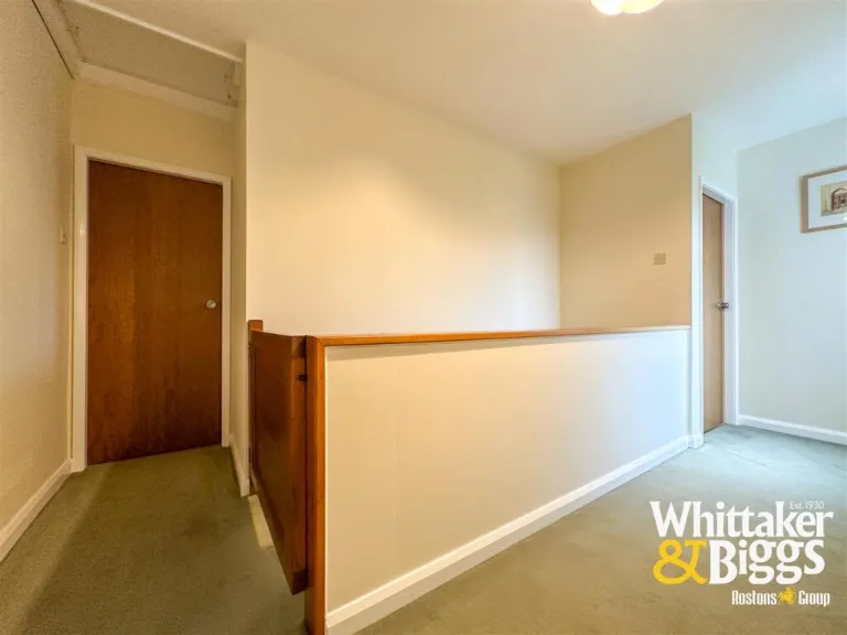
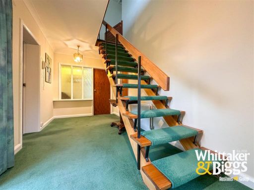
- HALLWAY:
- KITCHEN:
- PORCH:
- STUDY:
- WC:
- STORAGE:
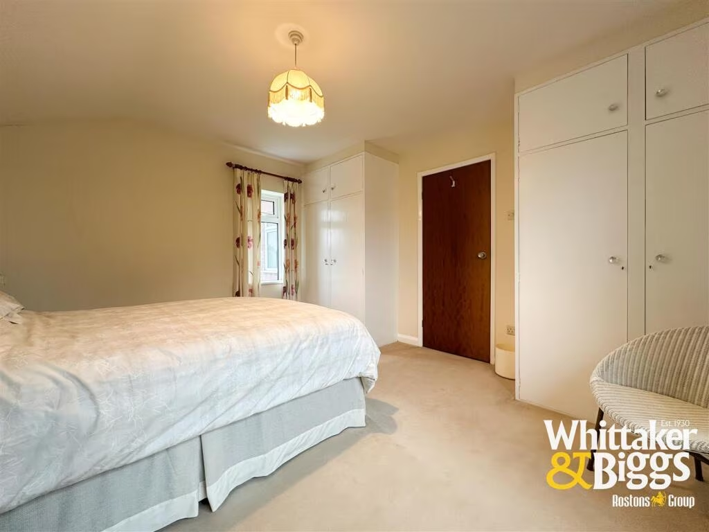
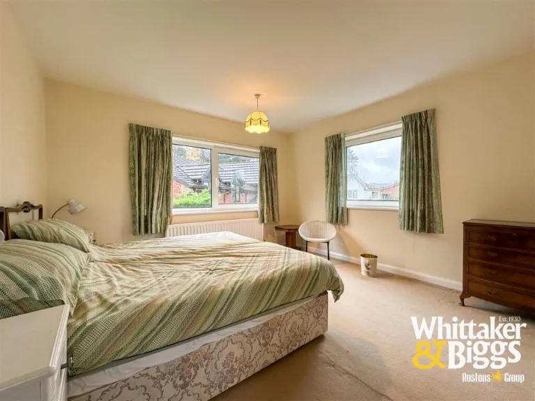
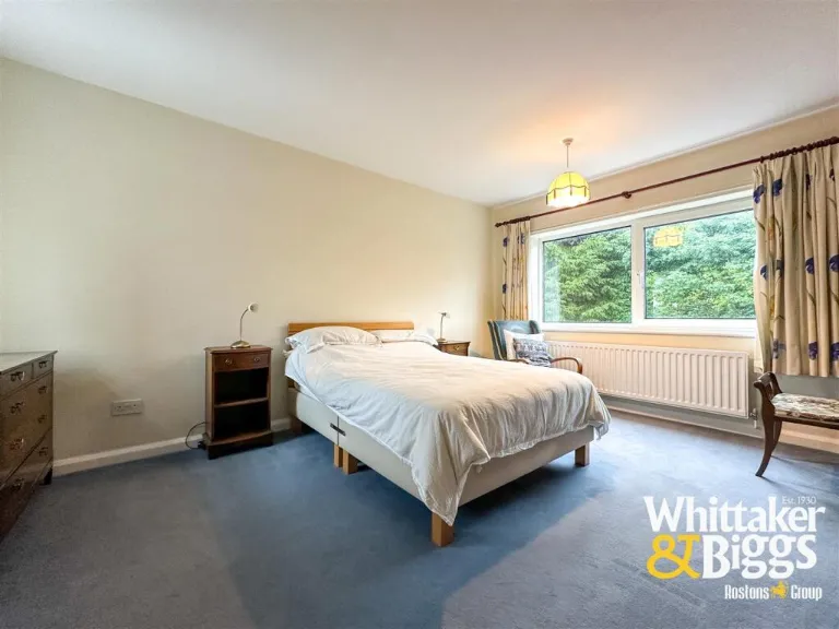
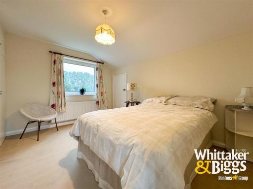
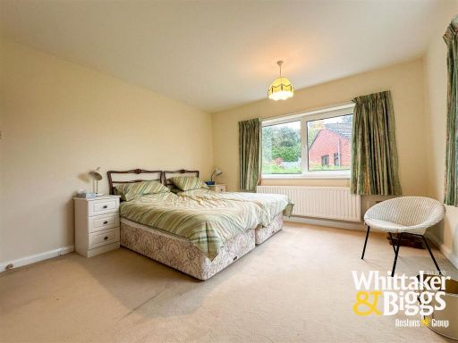
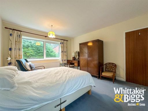
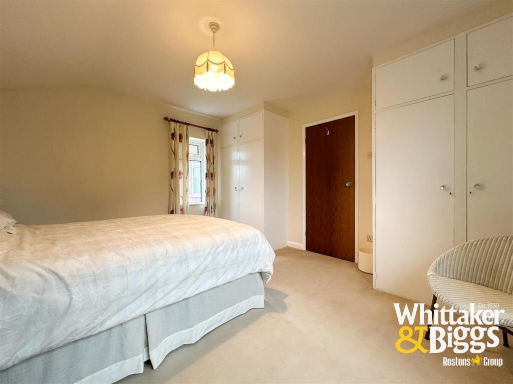
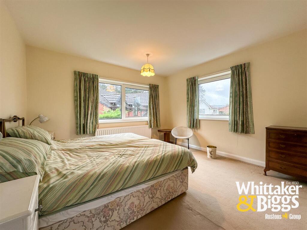
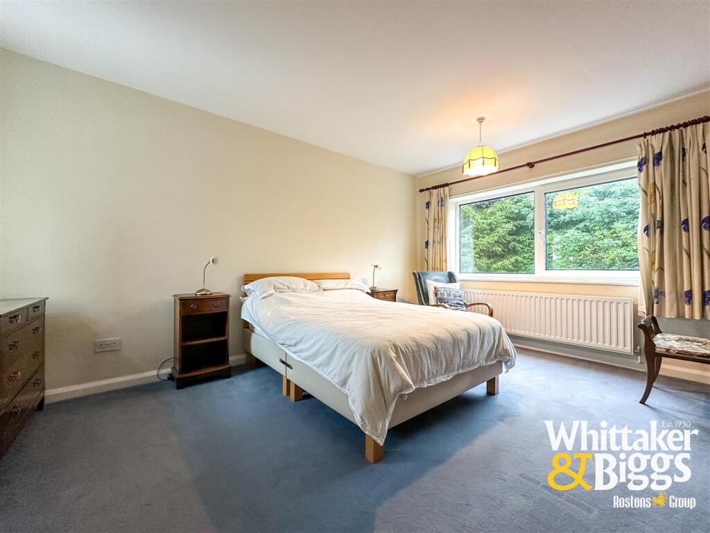
- BEDROOM THREE:
- BEDROOM TWO:
- LANDING:
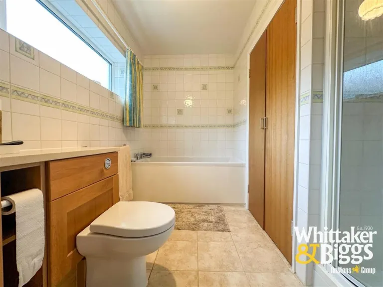
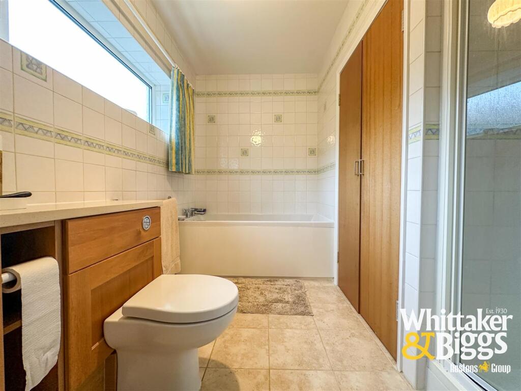
- BATHROOM:
- BEDROOM ONE:
Textual Property Features
- Has Garden
- Chain Free
- Success
Detected Visual Features
- detached house
- mid-century
- modern
- garage
- garden
- driveway
- brick exterior
- privacy hedges
- well-maintained
- suburban
- detached
- large plot
- brick
EPC Details
- Fully double glazed
- Cavity wall, as built, insulated (assumed)
- Boiler and radiators, mains gas
- Low energy lighting in 5% of fixed outlets
- Solid, insulated (assumed)
Nearby Schools
- St Leonard's CofE (A) First School
- Blackshaw Moor CofE First School
- All Saints CofE First School
- Woodcroft Academy
- Rushton CofE First School
- Werrington Primary School
- St Mary's Catholic Academy
- Westwood First School
- Leek First School
- Beresford Memorial CofE First School
- Churnet View Middle School
- St Werburgh's CE (A) Primary School
- St John's CofE Primary School
- St Edward's CofE Academy Cheddleton
- St Edward's Church of England Academy
- Westwood College
- Leek High School
- Evergreen
- Moorside High School
- Greenways Primary Academy
- Endon High School
- St Luke's CofE Academy Endon
- Endon Hall Primary School
- Horton St Michael's CofE First School
Nearest Bars And Restaurants
- Id: 558914470
- Tags:
- Amenity: pub
- Building: pub
- Name: Earl Grey Inn
- Source: Bing
- TagsNormalized:
- Lat: 53.1047523
- Lon: -2.017797
- FullGeoHash: gcqw456ttgmd
- PartitionGeoHash: gcqw
- Images:
- FoodStandards: null
- Distance: 1804.3
,- Id: 441948476
- Tags:
- Amenity: cafe
- Name: Hungry Horse Cafe
- TagsNormalized:
- Lat: 53.1046298
- Lon: -2.0228319
- FullGeoHash: gcqw1grhbs7p
- PartitionGeoHash: gcqw
- Images:
- FoodStandards: null
- Distance: 1804.2
,- Id: 559517440
- Tags:
- Amenity: pub
- Landuse: retail
- Name: The Flying Horse
- TagsNormalized:
- Lat: 53.1020554
- Lon: -2.0104876
- FullGeoHash: gcqw46bjbhxg
- PartitionGeoHash: gcqw
- Images:
- FoodStandards: null
- Distance: 1611.3
,- Id: 558544123
- Tags:
- Amenity: pub
- Landuse: retail
- Name: Pride of the Moorlands
- TagsNormalized:
- Lat: 53.0983638
- Lon: -2.0307091
- FullGeoHash: gcqw1f323h3t
- PartitionGeoHash: gcqw
- Images:
- FoodStandards: null
- Distance: 1333.5
,- Id: 246185495
- Tags:
- Amenity: pub
- Building: pub
- Name: Travellers Rest
- TagsNormalized:
- Lat: 53.0797861
- Lon: -2.0274899
- FullGeoHash: gcqtcygshj3c
- PartitionGeoHash: gcqt
- Images:
- FoodStandards: null
- Distance: 1119.6
}
Nearest General Shops
- Id: 462198705
- Tags:
- Name: Gill Newsagent's
- Shop: newsagent
- TagsNormalized:
- Lat: 53.1030458
- Lon: -2.0290632
- FullGeoHash: gcqw1g47xmhy
- PartitionGeoHash: gcqw
- Images:
- FoodStandards: null
- Distance: 1740.5
,- Id: 10606063787
- Tags:
- Name: Nina Hair & Beauty
- Shop: hairdresser
- TagsNormalized:
- Lat: 53.103033
- Lon: -2.0246121
- FullGeoHash: gcqw1gjex4gf
- PartitionGeoHash: gcqw
- Images:
- FoodStandards: null
- Distance: 1650.1
,- Id: 173499547
- Tags:
- Addr:
- Brand: B&M Bargains
- Brand:wikidata: Q4836931
- Brand:wikipedia: en:B&M
- Building: retail
- Contact:
- Website: https://www.bmstores.co.uk/stores/leek-401
- Name: B&M Bargains
- Old_name: Focus
- Shop: variety_store
- TagsNormalized:
- b&m
- retail
- variety store
- shop
- Lat: 53.0994421
- Lon: -2.0333532
- FullGeoHash: gcqw1drqemmy
- PartitionGeoHash: gcqw
- Images:
- FoodStandards: null
- Distance: 1535
}
Nearest Grocery shops
- Id: 308538529
- Tags:
- Building: yes
- Name: Newsmarket
- Shop: convenience
- TagsNormalized:
- Lat: 53.1031102
- Lon: -2.029039
- FullGeoHash: gcqw1g4kpcnz
- PartitionGeoHash: gcqw
- Images:
- FoodStandards: null
- Distance: 1746.5
,- Id: 441945188
- Tags:
- Name: Gills General Store
- Shop: convenience
- TagsNormalized:
- Lat: 53.1031451
- Lon: -2.0226411
- FullGeoHash: gcqw1gphjp9r
- PartitionGeoHash: gcqw
- Images:
- FoodStandards: null
- Distance: 1638.9
,- Id: 441945162
- Tags:
- Addr:
- Postcode: ST13 5BJ
- Street: Ashbourne Road
- Amenity: fuel
- Brand: Esso
- Brand:wikidata: Q867662
- Brand:wikipedia: en:Esso
- Fhrs:
- Name: Poplar Service Station
- Operator: Esso
- Shop: convenience
- Source:
- TagsNormalized:
- Lat: 53.1012224
- Lon: -2.0091559
- FullGeoHash: gcqw46bcp32c
- PartitionGeoHash: gcqw
- Images:
- FoodStandards:
- Id: 1259809
- FHRSID: 1259809
- LocalAuthorityBusinessID: 54726
- BusinessName: POPLAR SERVICE STATION
- BusinessType: Retailers - other
- BusinessTypeID: 4613
- AddressLine1: Ashbourne Road
- AddressLine2: Leek
- AddressLine3: Staffordshire Moorlands
- AddressLine4: null
- PostCode: ST13 5BJ
- RatingValue: 5
- RatingKey: fhrs_5_en-GB
- RatingDate: 2021-11-15
- LocalAuthorityCode: 293
- LocalAuthorityName: Staffordshire Moorlands
- LocalAuthorityWebSite: http://www.staffsmoorlands.gov.uk
- LocalAuthorityEmailAddress: Envhealth@highpeak.gov.uk
- Scores:
- Hygiene: 0
- Structural: 0
- ConfidenceInManagement: 5
- NewRatingPending: false
- Geocode:
- Longitude: -2.00958100000000
- Latitude: 53.10117680000000
- Distance: 1561.6
}
Nearest Religious buildings
- Id: 558563020
- Tags:
- Amenity: place_of_worship
- Building: residential
- Building:levels: 2
- Denomination: roman_catholic
- Name: Catholic Church of St Mary
- Religion: christian
- Source: Bing
- Wikidata: Q26558918
- TagsNormalized:
- place of worship
- residential
- catholic
- roman catholic
- church
- christian
- Lat: 53.1034978
- Lon: -2.025403
- FullGeoHash: gcqw1gjnk9qp
- PartitionGeoHash: gcqw
- Images:
- FoodStandards: null
- Distance: 1712.5
,- Id: 322510293
- Tags:
- Amenity: place_of_worship
- Building: church
- Religion: christian
- TagsNormalized:
- place of worship
- church
- christian
- Lat: 53.0799828
- Lon: -2.0400086
- FullGeoHash: gcqtcwft23gq
- PartitionGeoHash: gcqt
- Images:
- FoodStandards: null
- Distance: 1683.1
,- Id: 415880023
- Tags:
- Amenity: place_of_worship
- Building: church
- Denomination: anglican
- Name: All Saints' Church, Leek
- Religion: christian
- Wikidata: Q17541384
- TagsNormalized:
- place of worship
- church
- anglican
- christian
- Lat: 53.1023305
- Lon: -2.0238888
- FullGeoHash: gcqw1fyprzzh
- PartitionGeoHash: gcqw
- Images:
- FoodStandards: null
- Distance: 1563.6
}
Nearest Medical buildings
- Id: 10605980278
- Tags:
- Amenity: dentist
- Healthcare: dentist
- Name: St. Edward Street Dental Practice
- TagsNormalized:
- dentist
- health
- healthcare
- dental
- Lat: 53.1050787
- Lon: -2.0261788
- FullGeoHash: gcqw1gkxd85t
- PartitionGeoHash: gcqw
- Images:
- FoodStandards: null
- Distance: 1895.6
,- Id: 405381925
- Tags:
- Access: customers
- Amenity: parking
- Fee: no
- Name: Leek Health Centre Car Park
- Operator: Leek Health Centre
- Park_ride: no
- Parking: surface
- Supervised: no
- Surface: asphalt
- TagsNormalized:
- Lat: 53.1055556
- Lon: -2.019022
- FullGeoHash: gcqw459f33h4
- PartitionGeoHash: gcqw
- Images:
- FoodStandards: null
- Distance: 1891.1
,- Id: 559517364
- Tags:
- Addr:
- Postcode: ST13 5BQ
- Street: Ashbourne Road
- Amenity: hospital
- Beds: 44
- Emergency: no
- Healthcare: hospital
- Name: Leek Moorlands Hospital
- Note: Minor Injuries and Illnesses Unit
- Phone: +44 300 123 1894
- Website: https://www.mpft.nhs.uk/services/leek-moorlands-hospital
- TagsNormalized:
- Lat: 53.1028493
- Lon: -2.0095409
- FullGeoHash: gcqw470dw29d
- PartitionGeoHash: gcqw
- Images:
- FoodStandards: null
- Distance: 1716.7
,- Id: 443727534
- Tags:
- Amenity: clinic
- Healthcare: clinic
- Name: Edith Shaw Unit
- Note: part of John Munroe Independent Hospital
- TagsNormalized:
- clinic
- health
- healthcare
- unit
- Lat: 53.1026419
- Lon: -2.0275417
- FullGeoHash: gcqw1g596cgm
- PartitionGeoHash: gcqw
- Images:
- FoodStandards: null
- Distance: 1662.4
}
Nearest Airports
- Id: 1224469
- Tags:
- Addr:
- City: Manchester
- Country: GB
- Postcode: M90 1QX
- Aerodrome: international
- Aeroway: aerodrome
- Arp: yes
- Atis: 128.175
- Iata: MAN
- Icao: EGCC
- Name: Manchester Airport
- Note: rough sketched outline referring to Yahoo imagery - true boundary is where?
- Old_name: Ringway
- Operator: Manchester Airport PLC
- Size: 18720000
- Source:
- Tower_frequency: 118.625,119.400
- Type: multipolygon
- Website: https://www.manchesterairport.co.uk/
- Wikidata: Q8694
- Wikipedia: en:Manchester Airport
- TagsNormalized:
- airport
- international airport
- Lat: 53.3503197
- Lon: -2.2798822
- FullGeoHash: gcqrs05u4ukt
- PartitionGeoHash: gcqr
- Images:
- FoodStandards: null
- Distance: 33888
}
Nearest Leisure Facilities
- Id: 385540269
- Tags:
- Leisure: pitch
- Source: Bing
- Sport: soccer
- Surface: grass
- TagsNormalized:
- Lat: 53.0931238
- Lon: -2.0254332
- FullGeoHash: gcqw1cm1ggxe
- PartitionGeoHash: gcqw
- Images:
- FoodStandards: null
- Distance: 655.9
,- Id: 385540274
- Tags:
- Leisure: pitch
- Source: Bing
- Sport: soccer
- Surface: grass
- TagsNormalized:
- Lat: 53.0937288
- Lon: -2.0237568
- FullGeoHash: gcqw1cqm7h3s
- PartitionGeoHash: gcqw
- Images:
- FoodStandards: null
- Distance: 650.4
,- Id: 385540268
- Tags:
- Leisure: pitch
- Source: Bing
- Sport: soccer
- Surface: grass
- TagsNormalized:
- Lat: 53.0934417
- Lon: -2.0226993
- FullGeoHash: gcqw1cr5ewyh
- PartitionGeoHash: gcqw
- Images:
- FoodStandards: null
- Distance: 591.2
,- Id: 93940322
- Tags:
- Leisure: golf_course
- Name: Leek Golf Club
- TagsNormalized:
- golf
- golf course
- leisure
- club
- Lat: 53.0888687
- Lon: -2.0247868
- FullGeoHash: gcqw1bt9543t
- PartitionGeoHash: gcqw
- Images:
- FoodStandards: null
- Distance: 372.6
,- Id: 429722895
- Tags:
- Building: yes
- Leisure: sports_centre
- Source: Bing
- Sport: golf
- TagsNormalized:
- sports
- sports centre
- leisure
- golf
- Lat: 53.0902688
- Lon: -2.022501
- FullGeoHash: gcqw1bz30r3v
- PartitionGeoHash: gcqw
- Images:
- FoodStandards: null
- Distance: 290.2
}
Nearest Tourist attractions
- Id: 1070611799
- Tags:
- Historic:
- Name: Bradnop
- Railway: site
- Source: Eye, photos and OS 1" 7th series 1955-61
- Tourism: heritage_railway
- Website: http://www.churnet-valley-railway.co.uk/news/bradnop-station-renamed
- TagsNormalized:
- Lat: 53.0911207
- Lon: -1.9863703
- FullGeoHash: gcqw4bcw4nny
- PartitionGeoHash: gcqw
- Images:
- FoodStandards: null
- Distance: 2213.1
,- Id: 2467265381
- Tags:
- Name: White Hart
- Tourism: guest_house
- TagsNormalized:
- Lat: 53.1067659
- Lon: -2.0249981
- FullGeoHash: gcqw1gv3q4ey
- PartitionGeoHash: gcqw
- Images:
- FoodStandards: null
- Distance: 2061.9
,- Id: 171108661
- Tags:
- Amenity: clock
- Building: memorial
- Faces: 4
- Historic: memorial
- Name: Nicholson War Memorial
- Source: website; Bing
- Support: tower
- Tourism: attraction
- Url: http://www.nicholsonmemorial.org.uk
- Wikidata: Q7026637
- Wikipedia: en:Nicholson War Memorial
- TagsNormalized:
- Lat: 53.105631
- Lon: -2.0207499
- FullGeoHash: gcqw458d9p5s
- PartitionGeoHash: gcqw
- Images:
- FoodStandards: null
- Distance: 1902.1
}
Nearest Train stations
- Id: 1711412439
- Tags:
- Monorail: yes
- Name: Alton Towers Main Entrance
- Railway: station
- Station: monorail
- Tourism: attraction
- Usage: tourism
- TagsNormalized:
- railway
- station
- attraction
- tourism
- Lat: 52.9915619
- Lon: -1.8920461
- FullGeoHash: gcqtkyy60ph5
- PartitionGeoHash: gcqt
- Images:
- FoodStandards: null
- Distance: 13733.5
,- Id: 58978526
- Tags:
- Internet_access: no
- Name: Longton
- Naptan:
- Network: National Rail
- Public_transport: station
- Railway: station
- Ref:
- Source: NPE
- Wikidata: Q2096431
- Wikipedia: en:Longton railway station
- TagsNormalized:
- Lat: 52.9900417
- Lon: -2.1372966
- FullGeoHash: gcqmrqe9m7sp
- PartitionGeoHash: gcqm
- Images:
- FoodStandards: null
- Distance: 13501.4
,- Id: 8361780629
- Tags:
- Name: Foxfield Colliery
- Public_transport: station
- Railway: station
- Usage: tourism
- TagsNormalized:
- Lat: 52.9984067
- Lon: -2.0369415
- FullGeoHash: gcqt98hdpg46
- PartitionGeoHash: gcqt
- Images:
- FoodStandards: null
- Distance: 10093.1
,- Id: 671328140
- Tags:
- Name: Kingsley & Froghall
- Naptan:
- Operator: Churnet Valley Railway
- Platforms: 2
- Public_transport: station
- Railway: station
- Tourism: heritage_railway
- Usage: tourism
- TagsNormalized:
- Lat: 53.0215468
- Lon: -1.9645057
- FullGeoHash: gcqtek32zswq
- PartitionGeoHash: gcqt
- Images:
- FoodStandards: null
- Distance: 8299.7
,- Id: 478751924
- Tags:
- Listed_status: Grade II
- Name: Cheddleton
- Naptan:
- Public_transport: station
- Railway: station
- Tourism: heritage_railway
- Usage: tourism
- Wikidata: Q5089206
- TagsNormalized:
- Lat: 53.0654183
- Lon: -2.0272962
- FullGeoHash: gcqtcu7b2wfq
- PartitionGeoHash: gcqt
- Images:
- FoodStandards: null
- Distance: 2627.8
}
Nearest Hotels
- Id: 299206794
- Tags:
- Addr:
- Postcode: ST13 5DG
- Street: Ashbourne Road
- Brand: Premier Inn
- Brand:wikidata: Q2108626
- Brand:wikipedia: en:Premier Inn
- Building: hotel
- Fhrs:
- Internet_access: wlan
- Internet_access:fee: customers
- Internet_access:operator: Virgin Media
- Internet_access:ssid: Premier Inn Free Wi-Fi
- Name: Premier Inn
- Source: OS OpenData StreetView
- Source:addr: FHRS Open Data
- Tourism: hotel
- TagsNormalized:
- Lat: 53.1053928
- Lon: -2.0200753
- FullGeoHash: gcqw45912fdx
- PartitionGeoHash: gcqw
- Images:
- FoodStandards: null
- Distance: 1873.8
,- Id: 443727535
- Tags:
- Addr:
- Housenumber: 21
- Postcode: ST13 5NW
- Street: King Street
- Fhrs:
- Name: Peak Weavers Hotel
- Source:
- Tourism: hotel
- TagsNormalized:
- Lat: 53.1033814
- Lon: -2.0258057
- FullGeoHash: gcqw1ghve7cb
- PartitionGeoHash: gcqw
- Images:
- FoodStandards: null
- Distance: 1706.7
,- Id: 443727536
- Tags:
- Name: The Green Man Motel
- Tourism: hotel
- TagsNormalized:
- Lat: 53.1032178
- Lon: -2.0250381
- FullGeoHash: gcqw1gjktjq1
- PartitionGeoHash: gcqw
- Images:
- FoodStandards: null
- Distance: 1676.5
}
Tags
- detached house
- mid-century
- modern
- garage
- garden
- driveway
- brick exterior
- privacy hedges
- well-maintained
- suburban
- mid-century
- modern
- detached
- large plot
- garden
- brick
- driveway
Local Market Stats
- Average Price/sqft: £206
- Avg Income: £40000
- Rental Yield: 3.4%
- Social Housing: 3%
- Planning Success Rate: 83%
Similar Properties
 3 bedroom detached house for sale in Birchall Lane, Leek, ST13 — £475,000 • 3 bed • 1 bath • 738 ft²
 4 bedroom detached house for sale in Eastbourne Close, Leek, ST13 — £350,000 • 4 bed • 1 bath • 1458 ft²
 3 bedroom detached house for sale in Sandybrook Lane, Leek, Staffordshire, ST13 5RZ, ST13 — £525,000 • 3 bed • 2 bath • 2277 ft²
 3 bedroom detached house for sale in Kniveden Lane, Leek, ST13 — £335,000 • 3 bed • 1 bath • 847 ft²
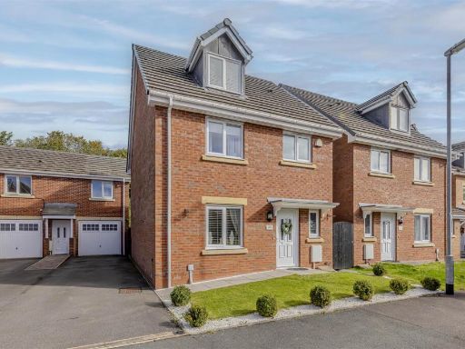 4 bedroom detached house for sale in Clover Grove, Leekbrook, Near Leek, Staffordshire, ST13 7AS, ST13 — £330,000 • 4 bed • 2 bath • 1475 ft²
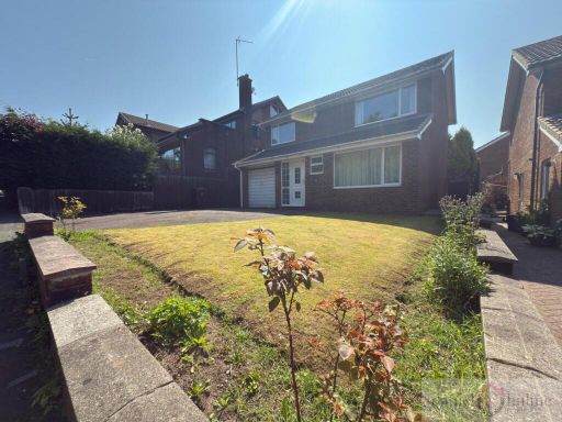 4 bedroom detached house for sale in Kniveden Lane, Leek, Staffordshire, ST13 5BE, ST13 — £325,000 • 4 bed • 1 bath • 1109 ft²
Meta
- {
"@context": "https://schema.org",
"@type": "Residence",
"name": "3 bedroom detached house for sale in Birchall Close, Bircha…",
"description": "",
"url": "https://propertypiper.co.uk/property/67c35a74-9a4a-4702-b5a5-febee060e7cf",
"image": "https://image-a.propertypiper.co.uk/7b03f155-1147-4f69-9425-28eab4709055-1024.jpeg",
"address": {
"@type": "PostalAddress",
"streetAddress": "DROMQUINNA, BIRCHALL CLOSE, LEEK",
"postalCode": "ST13 5RQ",
"addressLocality": "Staffordshire Moorlands",
"addressRegion": "Staffordshire Moorlands",
"addressCountry": "England"
},
"geo": {
"@type": "GeoCoordinates",
"latitude": 53.0885491,
"longitude": -2.0192324
},
"numberOfRooms": 3,
"numberOfBathroomsTotal": 1,
"floorSize": {
"@type": "QuantitativeValue",
"value": 1918,
"unitCode": "FTK"
},
"offers": {
"@type": "Offer",
"price": 495000,
"priceCurrency": "GBP",
"availability": "https://schema.org/InStock"
},
"additionalProperty": [
{
"@type": "PropertyValue",
"name": "Feature",
"value": "detached house"
},
{
"@type": "PropertyValue",
"name": "Feature",
"value": "mid-century"
},
{
"@type": "PropertyValue",
"name": "Feature",
"value": "modern"
},
{
"@type": "PropertyValue",
"name": "Feature",
"value": "garage"
},
{
"@type": "PropertyValue",
"name": "Feature",
"value": "garden"
},
{
"@type": "PropertyValue",
"name": "Feature",
"value": "driveway"
},
{
"@type": "PropertyValue",
"name": "Feature",
"value": "brick exterior"
},
{
"@type": "PropertyValue",
"name": "Feature",
"value": "privacy hedges"
},
{
"@type": "PropertyValue",
"name": "Feature",
"value": "well-maintained"
},
{
"@type": "PropertyValue",
"name": "Feature",
"value": "suburban"
},
{
"@type": "PropertyValue",
"name": "Feature",
"value": "mid-century"
},
{
"@type": "PropertyValue",
"name": "Feature",
"value": "modern"
},
{
"@type": "PropertyValue",
"name": "Feature",
"value": "detached"
},
{
"@type": "PropertyValue",
"name": "Feature",
"value": "large plot"
},
{
"@type": "PropertyValue",
"name": "Feature",
"value": "garden"
},
{
"@type": "PropertyValue",
"name": "Feature",
"value": "brick"
},
{
"@type": "PropertyValue",
"name": "Feature",
"value": "driveway"
}
]
}
High Res Floorplan Images
Compatible Floorplan Images
FloorplanImages Thumbnail