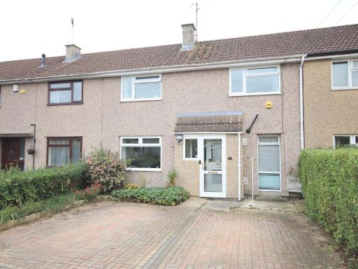
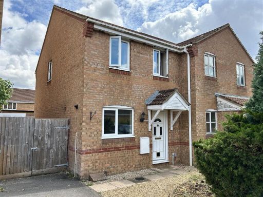
SN14 0LE - 3 bedroom terraced house for sale in Lamberts, Chippenham,…
View on Property Piper
3 bedroom terraced house for sale in Lamberts, Chippenham, SN14
Property Details
- Price: £279950
- Bedrooms: 3
- Bathrooms: 1
- Property Type: undefined
- Property SubType: undefined
Image Descriptions
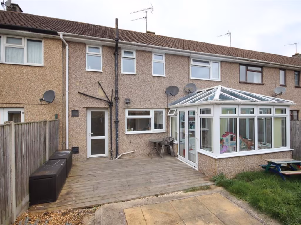
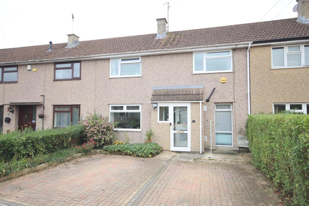
- exterior mid-20th century
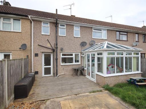
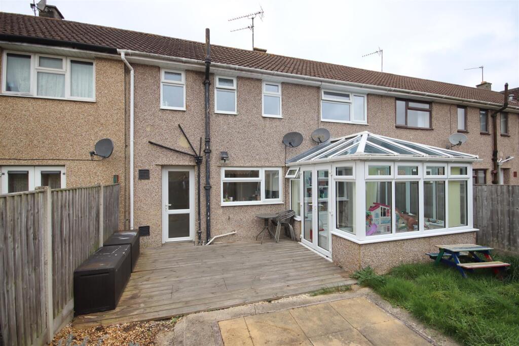
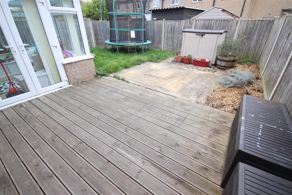
- backyard of a mid-20th century terraced house mid-20th century terraced
Floorplan Description
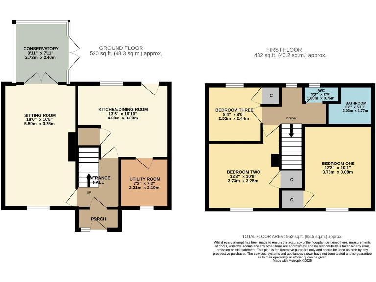
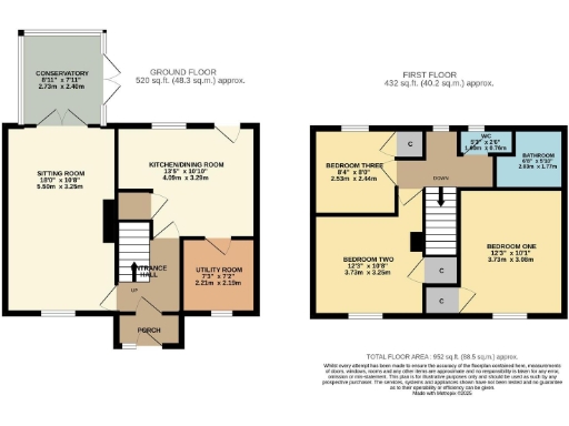
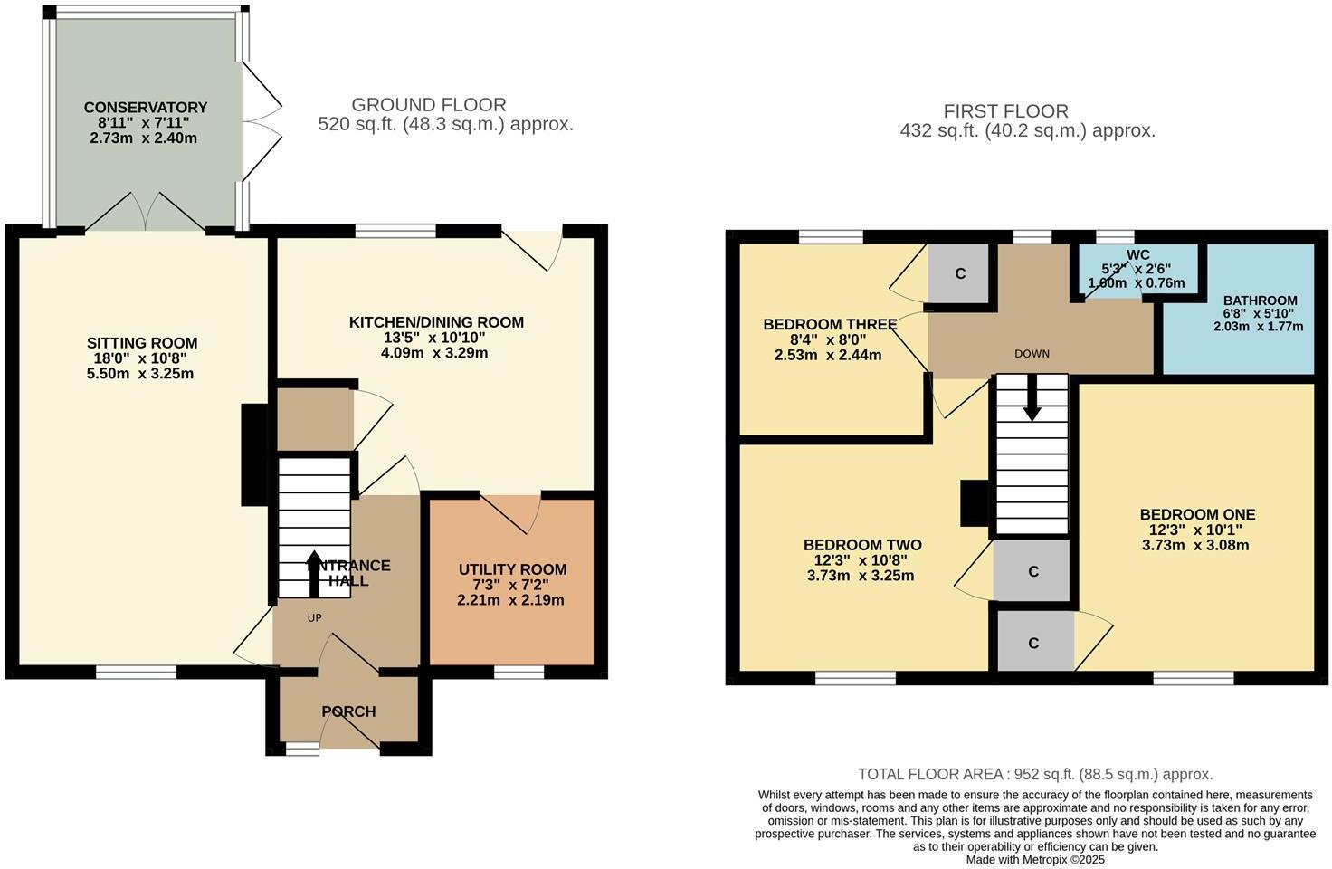
- Two-storey house with sitting room, kitchen/dining, utility and conservatory on ground floor; three bedrooms and bathroom/WC on first floor.
Rooms
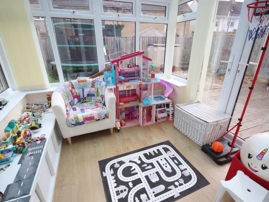
- CONSERVATORY:
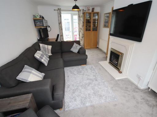
- SITTING ROOM:
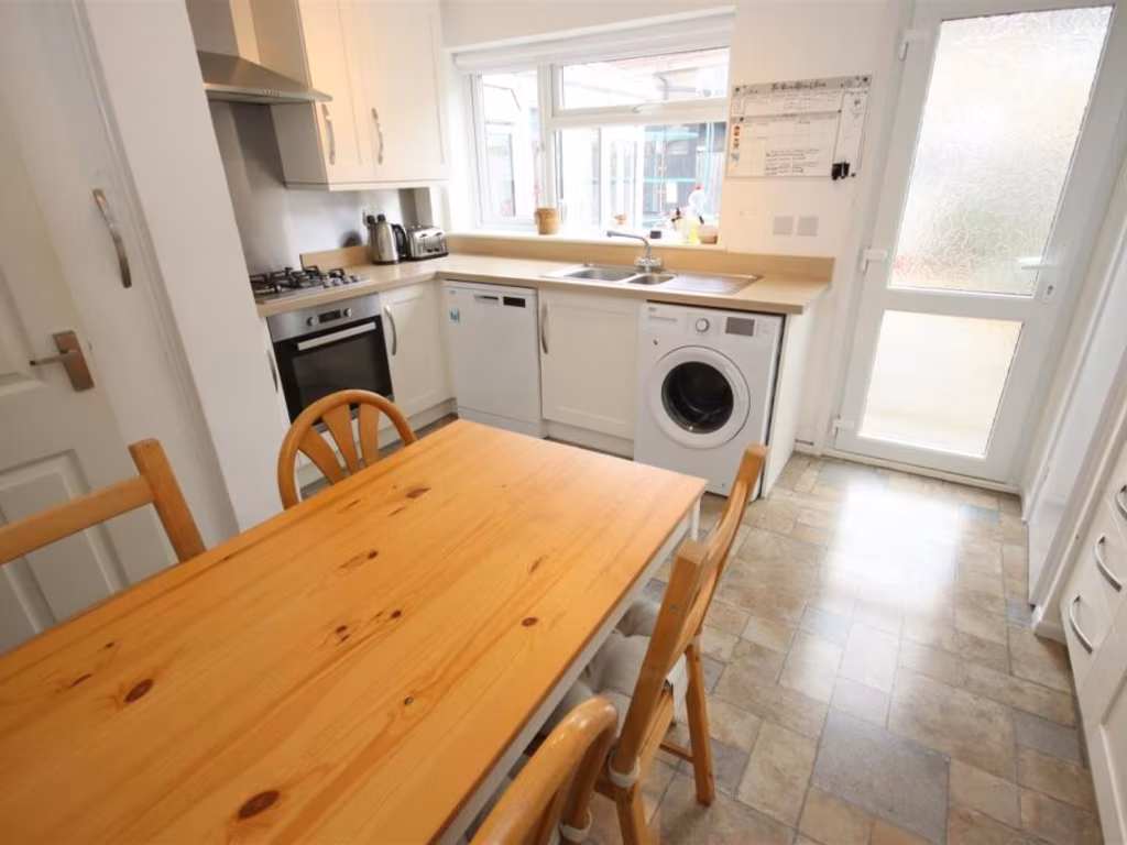
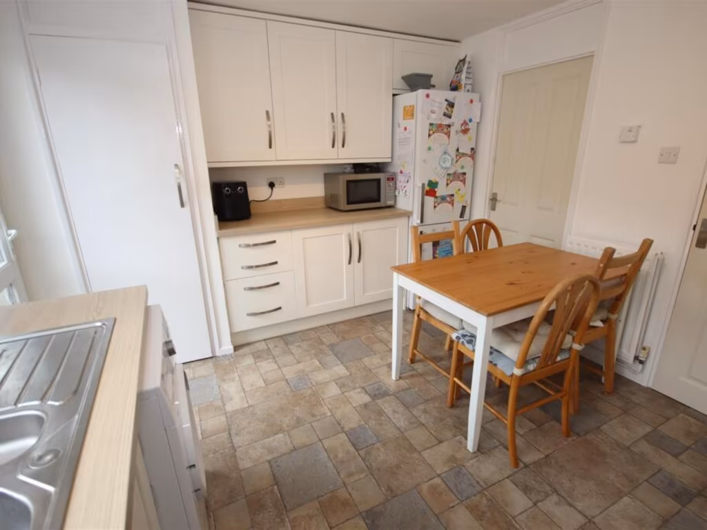
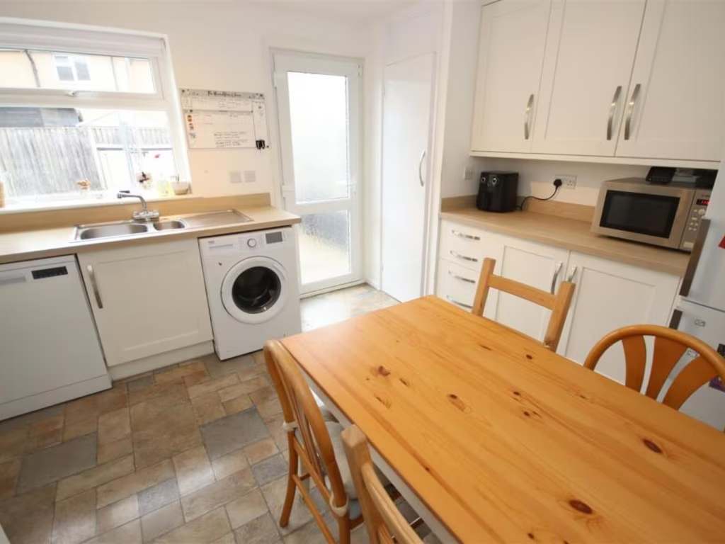
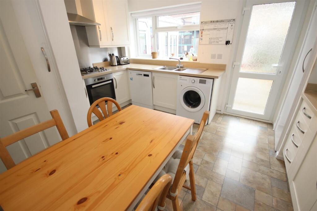
- KITCHEN/DINING ROOM:
- UTILITY ROOM:
- PORCH:
- ENTRANCE HALL:
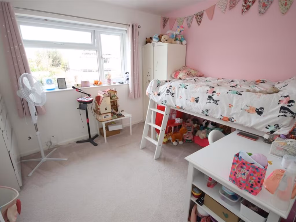
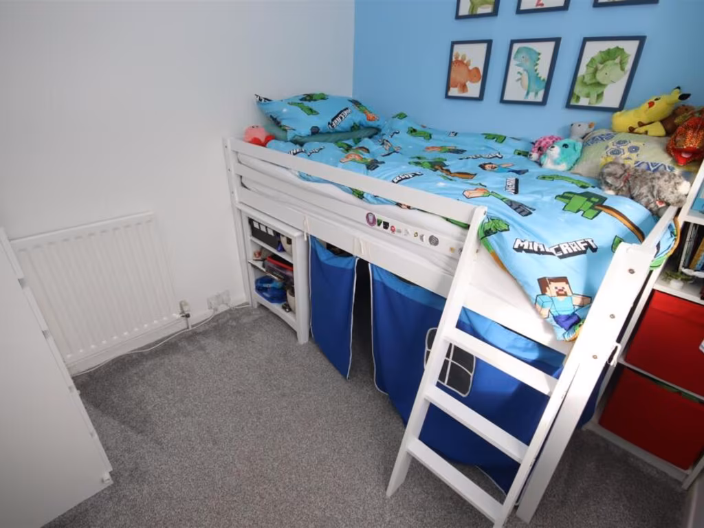
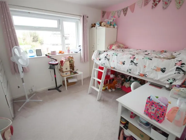
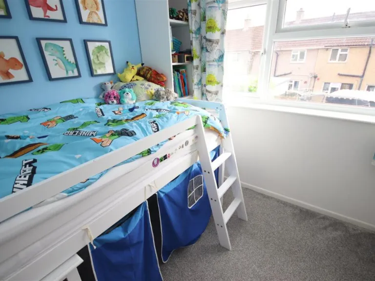
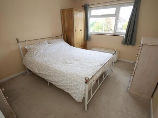
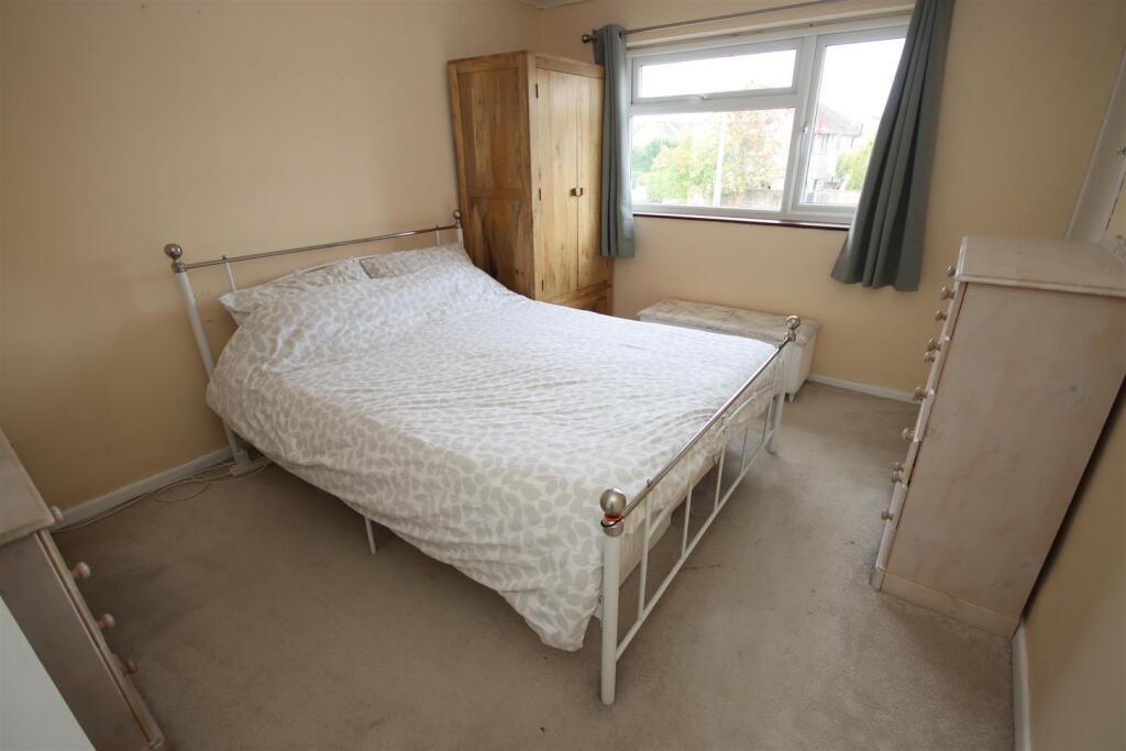
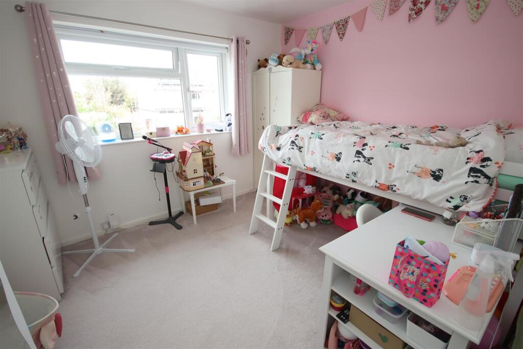
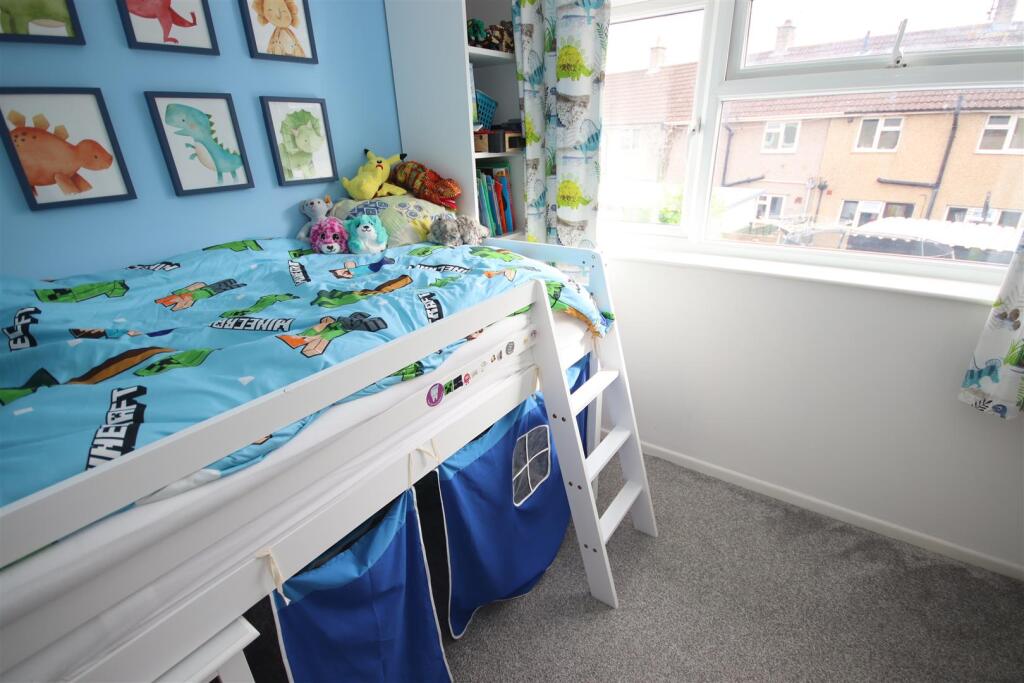
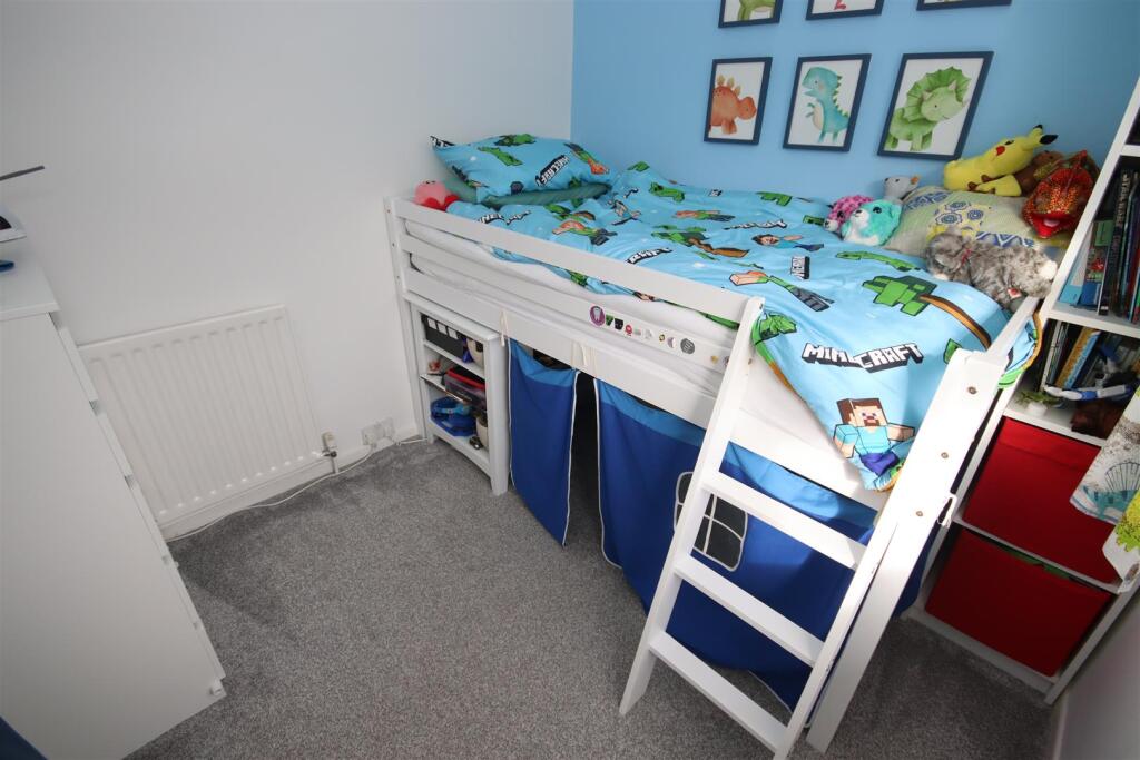
- BEDROOM THREE:
- BEDROOM TWO:
- BEDROOM ONE:
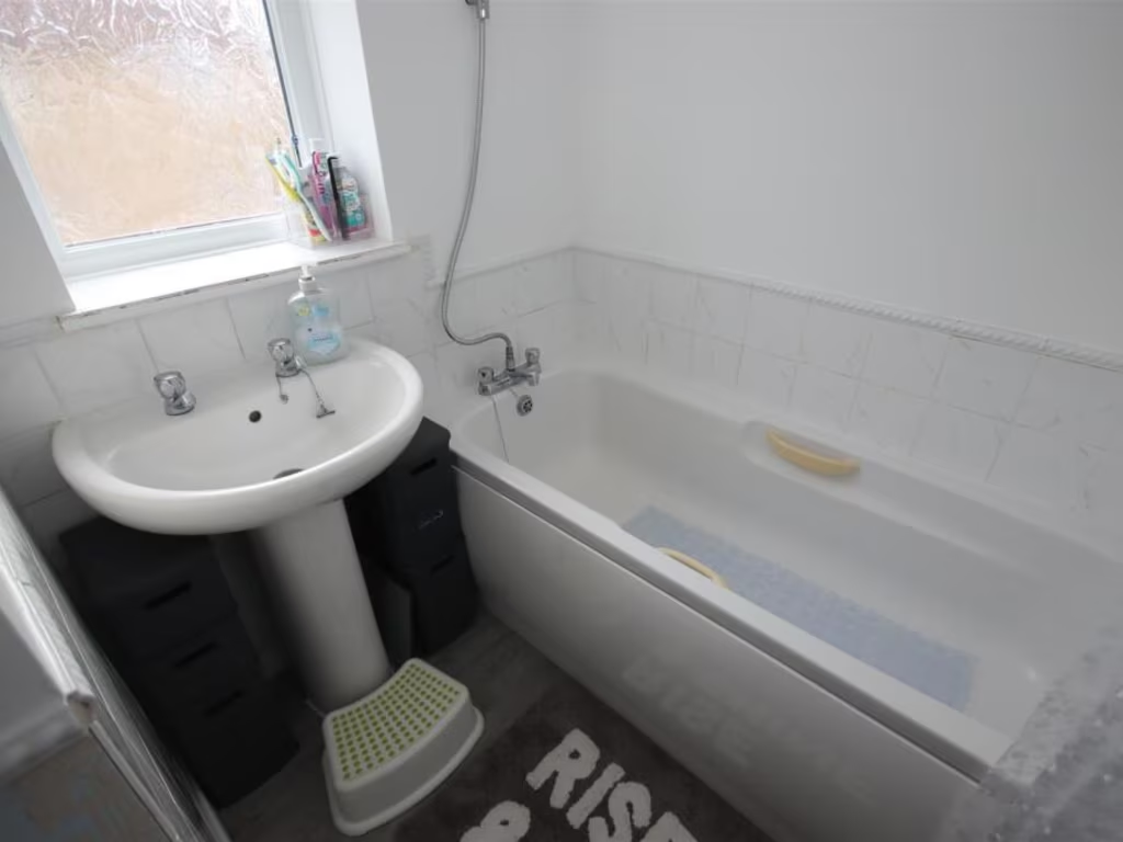
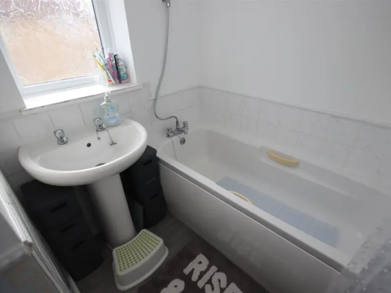
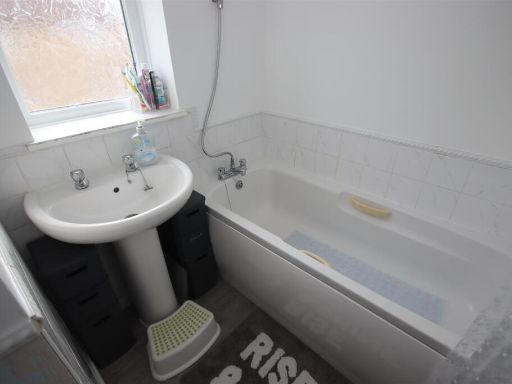
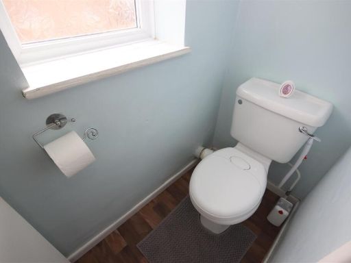
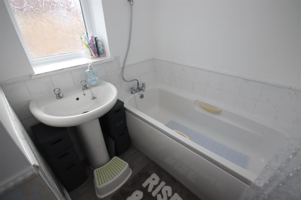
- BATHROOM:
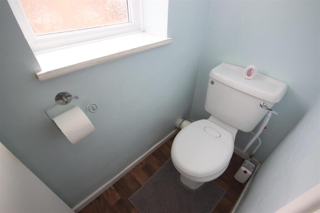
- WC:
Textual Property Features
Detected Visual Features
- mid-20th century
- terraced house
- two-storey
- concrete facade
- paved driveway
- basic condition
- needs modernization
- simple architecture
- residential neighborhood
- conservatory
- decking
- outdoor space
- low maintenance
- satellite dish
- potential for renovation
- concrete patio
EPC Details
- Fully double glazed
- System built, with external insulation
- Boiler and radiators, mains gas
- Low energy lighting in 40% of fixed outlets
- Solid, no insulation (assumed)
Nearby Schools
- St Patrick's Catholic Primary School, Corsham
- Heywood Prep
- Queen's Crescent School
- Frogwell Primary School
- Redland Primary School
- By Brook Valley CofE Primary School
- Kington St Michael Church of England Primary School
- Stanton St Quintin Primary and Nursery School
- Corsham Primary School
- Derry Hill Church of England Voluntary Aided Primary School
- Abbeyfield School
- Ivy Lane Primary School
- St Peter's CofE Academy
- Lacock Church of England Primary School
- The Corsham School
- The Corsham Regis Primary Academy
- Kings Lodge Primary School
- St Mary's Catholic Primary School
- Monkton Park Primary School
- Sheldon School
- Hardenhuish School
- Langley Fitzurse Church of England Primary School
- Sutton Benger Church of England Primary School
- Seagry Church of England Primary School
- Charter Primary School
- St Paul's Primary School
- Christian Malford CofE Primary School
Nearest Bars And Restaurants
- Id: 556523430
- Tags:
- Amenity: restaurant
- Building: yes
- Name: Fortune Inn
- TagsNormalized:
- Lat: 51.4587042
- Lon: -2.1357303
- FullGeoHash: gcnkxrub9vsp
- PartitionGeoHash: gcnk
- Images:
- FoodStandards: null
- Distance: 645.4
,- Id: 415605131
- Tags:
- Addr:
- City: Chippenham
- Housenumber: 305
- Postcode: SN14 0JJ
- Street: Hungerdown Lane
- Amenity: fast_food
- Name: Classic Wok
- TagsNormalized:
- Lat: 51.4610432
- Lon: -2.1381421
- FullGeoHash: gcnkz25n39tx
- PartitionGeoHash: gcnk
- Images:
- FoodStandards: null
- Distance: 358.2
,- Id: 411091940
- Tags:
- Amenity: pub
- Name: Steam Railway Company
- TagsNormalized:
- Lat: 51.4639807
- Lon: -2.136004
- FullGeoHash: gcnkz2sx7mrf
- PartitionGeoHash: gcnk
- Images:
- FoodStandards: null
- Distance: 170.9
,- Id: 564807260
- Tags:
- Amenity: pub
- Building: yes
- Name: The Kingfisher
- TagsNormalized:
- Lat: 51.4627404
- Lon: -2.1382871
- FullGeoHash: gcnkz2dbnq1s
- PartitionGeoHash: gcnk
- Images:
- FoodStandards: null
- Distance: 169.2
,- Id: 410330895
- Tags:
- Addr:
- City: Chippenham
- Postcode: SN14 0JL
- Street: Hungerdown Lane
- Amenity: pub
- Name: The Kingfisher
- TagsNormalized:
- Lat: 51.4628048
- Lon: -2.1381662
- FullGeoHash: gcnkz2e0945s
- PartitionGeoHash: gcnk
- Images:
- FoodStandards: null
- Distance: 162.8
}
Nearest General Shops
- Id: 265441883
- Tags:
- Brand: Peugeot;Seat;Kia;Citroen
- Building: retail
- Building:levels: 2
- Name: Chippenham Motor Company
- Second_hand: yes
- Shop: car
- TagsNormalized:
- peugeot
- kia
- retail
- motor
- shop
- Lat: 51.4637632
- Lon: -2.1436446
- FullGeoHash: gcnkz0xn1ky9
- PartitionGeoHash: gcnk
- Images:
- FoodStandards: null
- Distance: 365.4
,- Id: 1112270451
- Tags:
- Addr:
- City: Chippenham
- Housenumber: Unit C9/ C10
- Postcode: SN14 6LH
- Street: Bumpers Way
- Building: yes
- Contact:
- Email: gary_fortune@live.co.uk
- Name: G.F. Alloy Wheel Refurbishments & Smart Body Repair
- Operator: Gary Fortune
- Phone: +44 7876 531614
- Service:
- Vehicle:
- Body_repair: yes
- Painting: yes
- Shop: car_repair
- Website: https://en-gb.facebook.com/GFCarBodyRepairs/
- TagsNormalized:
- Lat: 51.4655433
- Lon: -2.1420423
- FullGeoHash: gcnkz300wb9k
- PartitionGeoHash: gcnk
- Images:
- FoodStandards: null
- Distance: 288.1
,- Id: 562041892
- Tags:
- TagsNormalized:
- Lat: 51.4639414
- Lon: -2.1356632
- FullGeoHash: gcnkz2sz5qn0
- PartitionGeoHash: gcnk
- Images:
- FoodStandards: null
- Distance: 194.9
}
Nearest Grocery shops
- Id: 572757070
- Tags:
- Brand: Tesco Express
- Brand:wikidata: Q98456772
- Brand:wikipedia: en:Tesco
- Building: yes
- Contact:
- Website: https://www.tesco.com/store-locator/chippenham/hungerdown-ln
- Name: Tesco Express
- Operator: Tesco
- Shop: convenience
- TagsNormalized:
- tesco
- tesco express
- convenience
- shop
- Lat: 51.459672
- Lon: -2.1378383
- FullGeoHash: gcnkxrgq2f0h
- PartitionGeoHash: gcnk
- Images:
- FoodStandards: null
- Distance: 511.8
,- Id: 415605128
- Tags:
- Amenity: fast_food
- Name: Lees Fish & Chip Shop
- TagsNormalized:
- fast food
- food
- chip
- fish
- shop
- Lat: 51.4638857
- Lon: -2.1355839
- FullGeoHash: gcnkz2syv79h
- PartitionGeoHash: gcnk
- Images:
- FoodStandards: null
- Distance: 201.5
,- Id: 9651333339
- Tags:
- Addr:
- Country: GB
- Housenumber: 64-66
- Postcode: SN14 0JB
- Street: Redland
- Brand: Morrisons Daily
- Brand:wikidata: Q99752411
- Contact:
- Website: https://my.morrisons.com/storefinder/36712
- Fhrs:
- Name: Morrisons Daily
- Operator: McColl's
- Operator:website: https://www.mccolls.co.uk/storelocator/chippenham-red-land/
- Operator:wikidata: Q16997477
- Shop: convenience
- TagsNormalized:
- morrisons
- morrisons daily
- convenience
- shop
- Lat: 51.4639846
- Lon: -2.1357778
- FullGeoHash: gcnkz2sz2y0d
- PartitionGeoHash: gcnk
- Images:
- FoodStandards:
- Id: 260739
- FHRSID: 260739
- LocalAuthorityBusinessID: PI/000011727
- BusinessName: Morrisons Daily
- BusinessType: Retailers - other
- BusinessTypeID: 4613
- AddressLine1: 64-66 Redland
- AddressLine2: Chippenham
- AddressLine3: Wiltshire
- AddressLine4: null
- PostCode: SN14 0JB
- RatingValue: 3
- RatingKey: fhrs_3_en-GB
- RatingDate: 2021-10-22
- LocalAuthorityCode: 709
- LocalAuthorityName: Wiltshire
- LocalAuthorityWebSite: http://www.wiltshire.gov.uk
- LocalAuthorityEmailAddress: publicprotectionwest@wiltshire.gov.uk
- Scores:
- Hygiene: 5
- Structural: 10
- ConfidenceInManagement: 10
- NewRatingPending: false
- Geocode:
- Longitude: -2.13579300000000
- Latitude: 51.46398400000000
- Distance: 186.3
}
Nearest Religious buildings
- Id: 564782960
- Tags:
- Amenity: place_of_worship
- Building: church
- Denomination: anglican
- Name: St Nicholas
- Religion: christian
- Wheelchair: no
- Wikidata: Q17544328
- TagsNormalized:
- place of worship
- church
- anglican
- christian
- Lat: 51.4716364
- Lon: -2.1314366
- FullGeoHash: gcnkz6pujbmw
- PartitionGeoHash: gcnk
- Images:
- FoodStandards: null
- Distance: 952.6
,- Id: 766486808
- Tags:
- Amenity: place_of_worship
- Name: Ladyfield Evangelical Church
- Religion: christian
- TagsNormalized:
- place of worship
- church
- evangelical
- christian
- Lat: 51.4569787
- Lon: -2.1368575
- FullGeoHash: gcnkxr7yxs5d
- PartitionGeoHash: gcnk
- Images:
- FoodStandards: null
- Distance: 816.9
,- Id: 568386294
- Tags:
- Amenity: place_of_worship
- Building: church
- Denomination: anglican
- Name: St Peter's
- Religion: christian
- Wikidata: Q105092372
- TagsNormalized:
- place of worship
- church
- anglican
- christian
- Lat: 51.4608345
- Lon: -2.1423472
- FullGeoHash: gcnkz0pvpdy5
- PartitionGeoHash: gcnk
- Images:
- FoodStandards: null
- Distance: 467.6
}
Nearest Medical buildings
- Id: 411733674
- Tags:
- Amenity: pharmacy
- Dispensing: yes
- Healthcare: pharmacy
- Name: Morrisons Pharmacy
- Opening_hours: Mo-Fr 09:00-19:00; Sa 09:00-18:00; Su 10:00-16:00
- Operator: Morrisons
- Wheelchair: yes
- TagsNormalized:
- pharmacy
- health
- healthcare
- morrisons
- Lat: 51.477049
- Lon: -2.1302864
- FullGeoHash: gcnkze0g89rq
- PartitionGeoHash: gcnk
- Images:
- FoodStandards: null
- Distance: 1529.9
,- Id: 544001668
- Tags:
- Amenity: doctors
- Building: yes
- Healthcare: doctor
- Name: Rowden Surgery
- TagsNormalized:
- doctor
- doctors
- health
- healthcare
- surgery
- Lat: 51.4538733
- Lon: -2.1250731
- FullGeoHash: gcnkxwusd1nt
- PartitionGeoHash: gcnk
- Images:
- FoodStandards: null
- Distance: 1479.9
,- Id: 410563585
- Tags:
- Addr:
- City: Chippenham
- Housename: Hathaway Medical Centre
- Postcode: SN14 6GT
- Street: Middlefield Road
- Amenity: pharmacy
- Brand: Lloyds Pharmacy
- Brand:wikidata: Q6662870
- Brand:wikipedia: en:LloydsPharmacy
- Dispensing: yes
- Drive_through: no
- Healthcare: pharmacy
- Name: Lloyds Pharmacy
- TagsNormalized:
- pharmacy
- lloyds pharmacy
- health
- healthcare
- Lat: 51.4674616
- Lon: -2.1394511
- FullGeoHash: gcnkz365enjx
- PartitionGeoHash: gcnk
- Images:
- FoodStandards: null
- Distance: 363
,- Id: 611000783
- Tags:
- Addr:
- City: Chippenham
- Housename: Hathaway Medical Centre
- Postcode: SN14 6GT
- Street: Middlefield Road
- Amenity: clinic
- Building: yes
- Healthcare: clinic
- Healthcare:speciality: general;dentistry
- Name: Hathaway Medical Centre
- Operator: NHS
- Operator:wikidata: Q918396
- TagsNormalized:
- clinic
- health
- healthcare
- general
- dentist
- dentistry
- Lat: 51.4673896
- Lon: -2.1396992
- FullGeoHash: gcnkz33gm2u9
- PartitionGeoHash: gcnk
- Images:
- FoodStandards: null
- Distance: 359
}
Nearest Airports
- Id: 47483196
- Tags:
- Aerodrome: international
- Aeroway: aerodrome
- Iata: BRS
- Icao: EGGD
- Internet_access: wlan
- Internet_access:fee: no
- Name: Bristol Airport
- Type: public
- Website: https://www.bristolairport.co.uk/
- Wikidata: Q8725
- Wikipedia: en:Bristol Airport
- TagsNormalized:
- airport
- international airport
- Lat: 51.3830799
- Lon: -2.7186615
- FullGeoHash: gcnh64h24s74
- PartitionGeoHash: gcnh
- Images:
- FoodStandards: null
- Distance: 41231.2
}
Nearest Leisure Facilities
- Id: 626056793
- Tags:
- TagsNormalized:
- Lat: 51.4635598
- Lon: -2.1334148
- FullGeoHash: gcnkz2wkzyfs
- PartitionGeoHash: gcnk
- Images:
- FoodStandards: null
- Distance: 356.1
,- Id: 582315408
- Tags:
- Leisure: pitch
- Sport: soccer
- TagsNormalized:
- Lat: 51.4641714
- Lon: -2.1420936
- FullGeoHash: gcnkz2b0t8gh
- PartitionGeoHash: gcnk
- Images:
- FoodStandards: null
- Distance: 254
,- Id: 35770601
- Tags:
- Leisure: park
- Name: Little Battens Park
- TagsNormalized:
- Lat: 51.4642553
- Lon: -2.141743
- FullGeoHash: gcnkz2b3jb88
- PartitionGeoHash: gcnk
- Images:
- FoodStandards: null
- Distance: 229.5
,- Id: 36817512
- Tags:
- Leisure: playground
- Name: Little Battens Play Area
- TagsNormalized:
- Lat: 51.464552
- Lon: -2.1413475
- FullGeoHash: gcnkz2bdwzzd
- PartitionGeoHash: gcnk
- Images:
- FoodStandards: null
- Distance: 204.7
,- Id: 548762411
- Tags:
- TagsNormalized:
- Lat: 51.463077
- Lon: -2.1363655
- FullGeoHash: gcnkz2s65hfk
- PartitionGeoHash: gcnk
- Images:
- FoodStandards: null
- Distance: 194.3
}
Nearest Tourist attractions
- Id: 10563771249
- Tags:
- TagsNormalized:
- Lat: 51.4698916
- Lon: -2.1509492
- FullGeoHash: gcnkz1c9z70n
- PartitionGeoHash: gcnk
- Images:
- FoodStandards: null
- Distance: 1069.7
,- Id: 1684784079
- Tags:
- Addr:
- Housenumber: 35
- Postcode: SN15 1JT
- Street: Marshfield Road
- Name: Number 35
- Tourism: guest_house
- TagsNormalized:
- Lat: 51.4630658
- Lon: -2.1238143
- FullGeoHash: gcnkz8t6pdc3
- PartitionGeoHash: gcnk
- Images:
- FoodStandards: null
- Distance: 1021.2
,- Id: 10563771250
- Tags:
- TagsNormalized:
- Lat: 51.4697634
- Lon: -2.150109
- FullGeoHash: gcnkz1f34g69
- PartitionGeoHash: gcnk
- Images:
- FoodStandards: null
- Distance: 1014.4
}
Nearest Bus stations and stops
- Id: 431324859
- Tags:
- Bus: yes
- Highway: bus_stop
- Public_transport: platform
- TagsNormalized:
- Lat: 51.4756744
- Lon: -2.1324313
- FullGeoHash: gcnkz6z5w9py
- PartitionGeoHash: gcnk
- Images:
- FoodStandards: null
- Distance: 1335.6
,- Id: 422673115
- Tags:
- Bus: yes
- Highway: bus_stop
- Public_transport: platform
- TagsNormalized:
- Lat: 51.457514
- Lon: -2.1225718
- FullGeoHash: gcnkxxw3srzg
- PartitionGeoHash: gcnk
- Images:
- FoodStandards: null
- Distance: 1330.3
,- Id: 10007462415
- Tags:
- Bus: yes
- Highway: bus_stop
- Name: Greenway Park
- Public_transport: platform
- Ref: wilampaw
- TagsNormalized:
- Lat: 51.466923
- Lon: -2.1209742
- FullGeoHash: gcnkz9r899z4
- PartitionGeoHash: gcnk
- Images:
- FoodStandards: null
- Distance: 1245
,- Id: 10007462414
- Tags:
- Bus: yes
- Highway: bus_stop
- Name: Long Ridings
- Public_transport: platform
- Ref: wilamjma
- TagsNormalized:
- Lat: 51.4700092
- Lon: -2.1240832
- FullGeoHash: gcnkz9v6930u
- PartitionGeoHash: gcnk
- Images:
- FoodStandards: null
- Distance: 1181.7
,- Id: 5468141036
- Tags:
- Bus: yes
- Highway: bus_stop
- Public_transport: stop_position
- TagsNormalized:
- Lat: 51.4744178
- Lon: -2.1338578
- FullGeoHash: gcnkz6whjwbq
- PartitionGeoHash: gcnk
- Images:
- FoodStandards: null
- Distance: 1173.1
}
Nearest Hotels
- Id: 742873831
- Tags:
- Brand: Travelodge
- Brand:wikidata: Q9361374
- Brand:wikipedia: en:Travelodge UK
- Building: yes
- Internet_access: wlan
- Internet_access:fee: customers
- Internet_access:ssid: Travelodge WiFi
- Name: Travelodge Chippenham
- Tourism: hotel
- TagsNormalized:
- Lat: 51.4640799
- Lon: -2.1129492
- FullGeoHash: gcnkzbtruxyf
- PartitionGeoHash: gcnk
- Images:
- FoodStandards: null
- Distance: 1765.3
,- Id: 265977094
- Tags:
- Addr:
- Full: Cepen Way, West Cepen Park, Chippenham SN14 6UZ
- Brand: Premier Inn
- Brand:wikidata: Q2108626
- Brand:wikipedia: en:Premier Inn
- Building: retail
- Internet_access: wlan
- Internet_access:fee: customers
- Internet_access:operator: Virgin Media
- Internet_access:ssid: Premier Inn Free Wi-Fi
- Name: Premier Inn
- Operator: Premier Inn
- Tourism: hotel
- TagsNormalized:
- premier
- inn
- retail
- hotel
- tourism
- Lat: 51.4786559
- Lon: -2.1317318
- FullGeoHash: gcnkz7rszhcx
- PartitionGeoHash: gcnk
- Images:
- FoodStandards: null
- Distance: 1666.7
,- Id: 433076423
- Tags:
- Addr:
- City: Chippenham
- Housenumber: 81-82
- Postcode: SN15 1JR
- Street: Marshfield Road
- Name: Pines Hotel
- Tourism: hotel
- TagsNormalized:
- Lat: 51.4623211
- Lon: -2.1218679
- FullGeoHash: gcnkz8qvszuw
- PartitionGeoHash: gcnk
- Images:
- FoodStandards: null
- Distance: 1167.4
}
Tags
- mid-20th century
- terraced house
- two-storey
- concrete facade
- paved driveway
- basic condition
- needs modernization
- simple architecture
- residential neighborhood
- terraced house
- mid-20th century
- conservatory
- decking
- outdoor space
- low maintenance
- satellite dish
- potential for renovation
- concrete patio
Local Market Stats
- Average Price/sqft: £341
- Avg Income: £52900
- Rental Yield: 4.1%
- Social Housing: 6%
- Planning Success Rate: 92%
Similar Properties
 3 bedroom terraced house for sale in Ascot Close, Chippenham, SN14 — £275,000 • 3 bed • 1 bath • 685 ft²
 3 bedroom terraced house for sale in Mount Pleasant, Chippenham, Wiltshire, SN14 — £375,000 • 3 bed • 2 bath • 1221 ft²
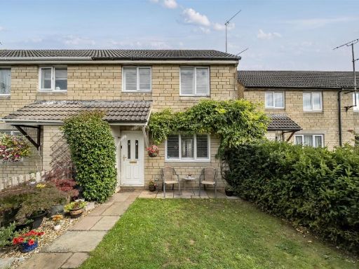 3 bedroom terraced house for sale in Charter Road, Chippenham, SN15 — £270,000 • 3 bed • 1 bath • 565 ft²
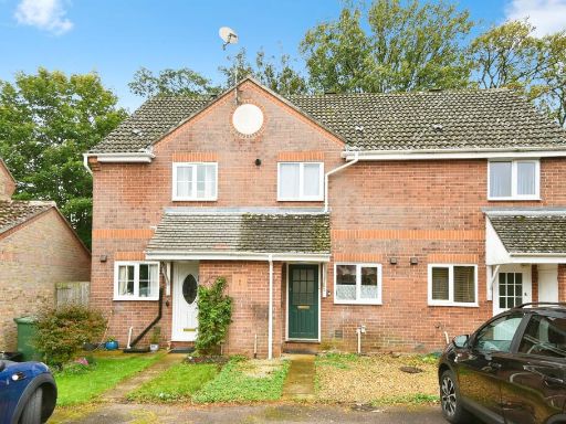 2 bedroom terraced house for sale in Twickenham Way, Chippenham, SN15 — £240,000 • 2 bed • 1 bath • 549 ft²
 3 bedroom detached house for sale in Orchard Road, Chippenham, SN14 — £395,000 • 3 bed • 1 bath • 1131 ft²
 3 bedroom terraced house for sale in Patchway, Chippenham, SN14 — £260,000 • 3 bed • 1 bath • 915 ft²
Meta
- {
"@context": "https://schema.org",
"@type": "Residence",
"name": "3 bedroom terraced house for sale in Lamberts, Chippenham,…",
"description": "",
"url": "https://propertypiper.co.uk/property/6492772c-05b4-46db-8e34-98b7663fcd59",
"image": "https://image-a.propertypiper.co.uk/bc7c9ea9-e6a3-47ce-b6ab-b9606501dfeb-1024.jpeg",
"address": {
"@type": "PostalAddress",
"streetAddress": "16 LAMBERTS CHIPPENHAM",
"postalCode": "SN14 0LE",
"addressLocality": "Wiltshire",
"addressRegion": "Chippenham",
"addressCountry": "England"
},
"geo": {
"@type": "GeoCoordinates",
"latitude": 51.464259581435655,
"longitude": -2.1384302213619324
},
"numberOfRooms": 3,
"numberOfBathroomsTotal": 1,
"floorSize": {
"@type": "QuantitativeValue",
"value": 952,
"unitCode": "FTK"
},
"offers": {
"@type": "Offer",
"price": 279950,
"priceCurrency": "GBP",
"availability": "https://schema.org/InStock"
},
"additionalProperty": [
{
"@type": "PropertyValue",
"name": "Feature",
"value": "mid-20th century"
},
{
"@type": "PropertyValue",
"name": "Feature",
"value": "terraced house"
},
{
"@type": "PropertyValue",
"name": "Feature",
"value": "two-storey"
},
{
"@type": "PropertyValue",
"name": "Feature",
"value": "concrete facade"
},
{
"@type": "PropertyValue",
"name": "Feature",
"value": "paved driveway"
},
{
"@type": "PropertyValue",
"name": "Feature",
"value": "basic condition"
},
{
"@type": "PropertyValue",
"name": "Feature",
"value": "needs modernization"
},
{
"@type": "PropertyValue",
"name": "Feature",
"value": "simple architecture"
},
{
"@type": "PropertyValue",
"name": "Feature",
"value": "residential neighborhood"
},
{
"@type": "PropertyValue",
"name": "Feature",
"value": "terraced house"
},
{
"@type": "PropertyValue",
"name": "Feature",
"value": "mid-20th century"
},
{
"@type": "PropertyValue",
"name": "Feature",
"value": "conservatory"
},
{
"@type": "PropertyValue",
"name": "Feature",
"value": "decking"
},
{
"@type": "PropertyValue",
"name": "Feature",
"value": "outdoor space"
},
{
"@type": "PropertyValue",
"name": "Feature",
"value": "low maintenance"
},
{
"@type": "PropertyValue",
"name": "Feature",
"value": "satellite dish"
},
{
"@type": "PropertyValue",
"name": "Feature",
"value": "potential for renovation"
},
{
"@type": "PropertyValue",
"name": "Feature",
"value": "concrete patio"
}
]
}
High Res Floorplan Images
Compatible Floorplan Images
FloorplanImages Thumbnail