GL4 4WQ - 3 bedroom detached house for sale in Tern Close, Abbeydale,…
View on Property Piper
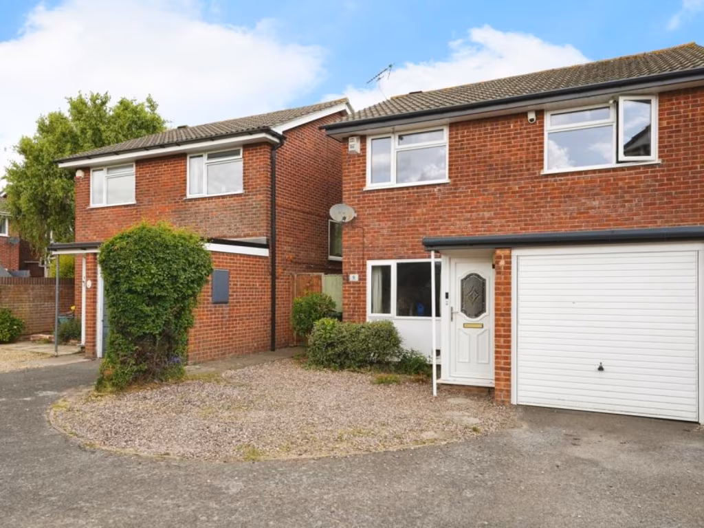
3 bedroom detached house for sale in Tern Close, Abbeydale, Gloucester, Gloucestershire, GL4
Property Details
- Price: £325000
- Bedrooms: 3
- Bathrooms: 2
- Property Type: undefined
- Property SubType: undefined
Image Descriptions
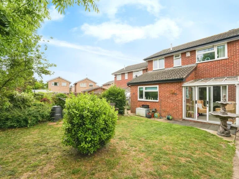
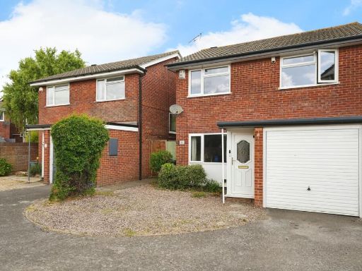
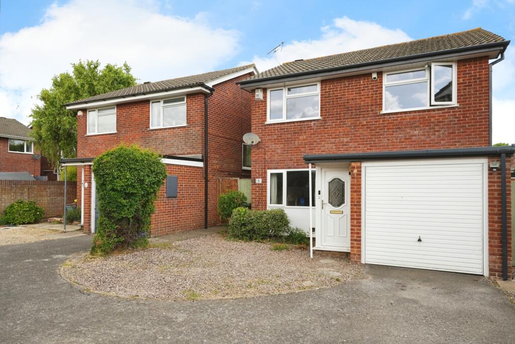
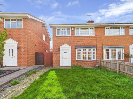
- semi-detached house modern
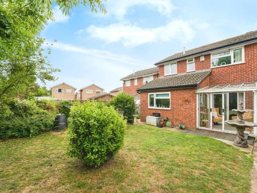
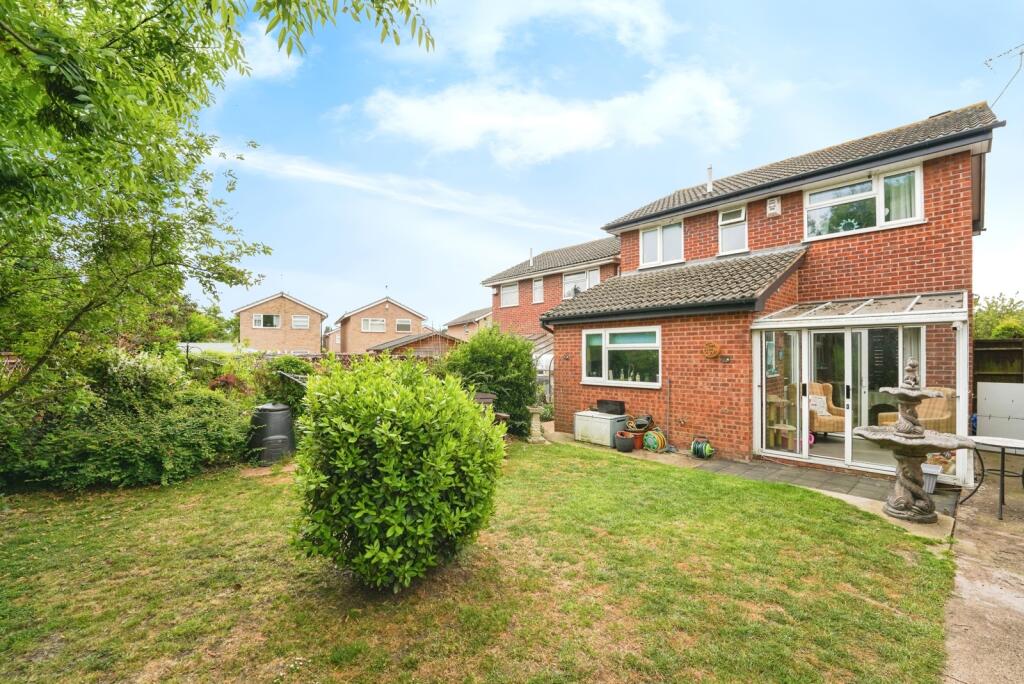
- rear view of suburban house modern
Floorplan Description
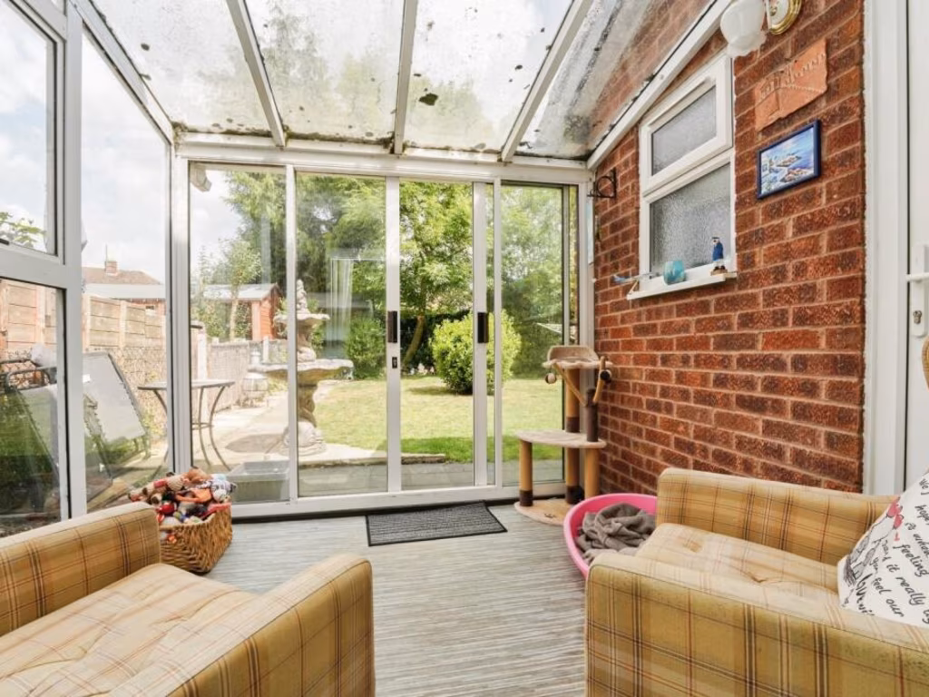
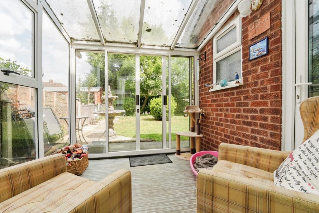
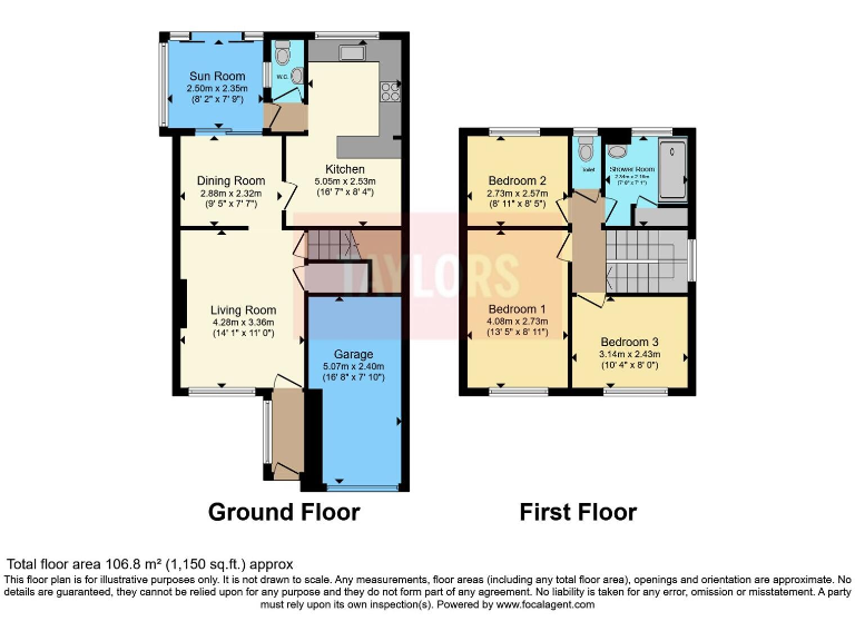
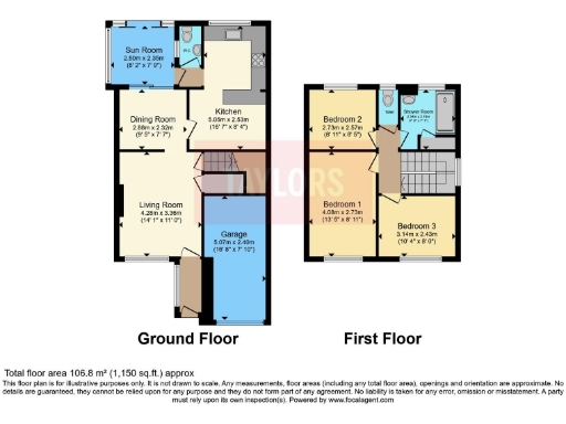
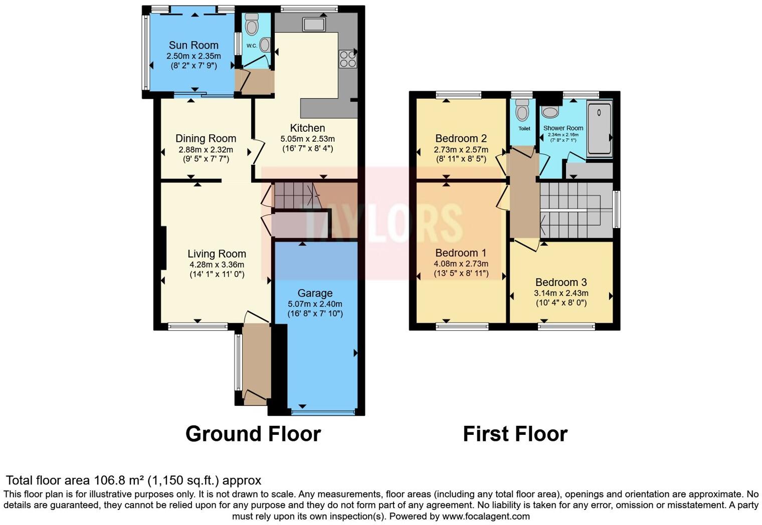
- This property is a two-story house with three bedrooms and various living spaces, including a sun room and a garage.
Rooms
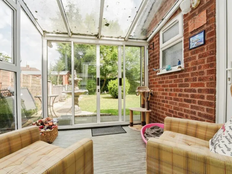
- Sun Room: small
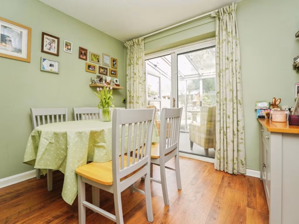
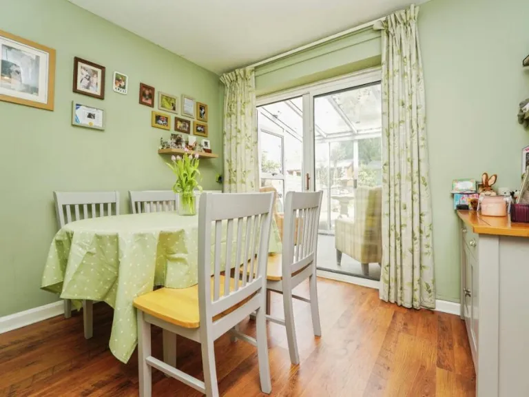
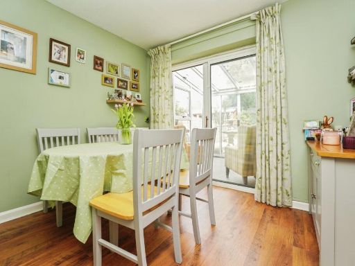
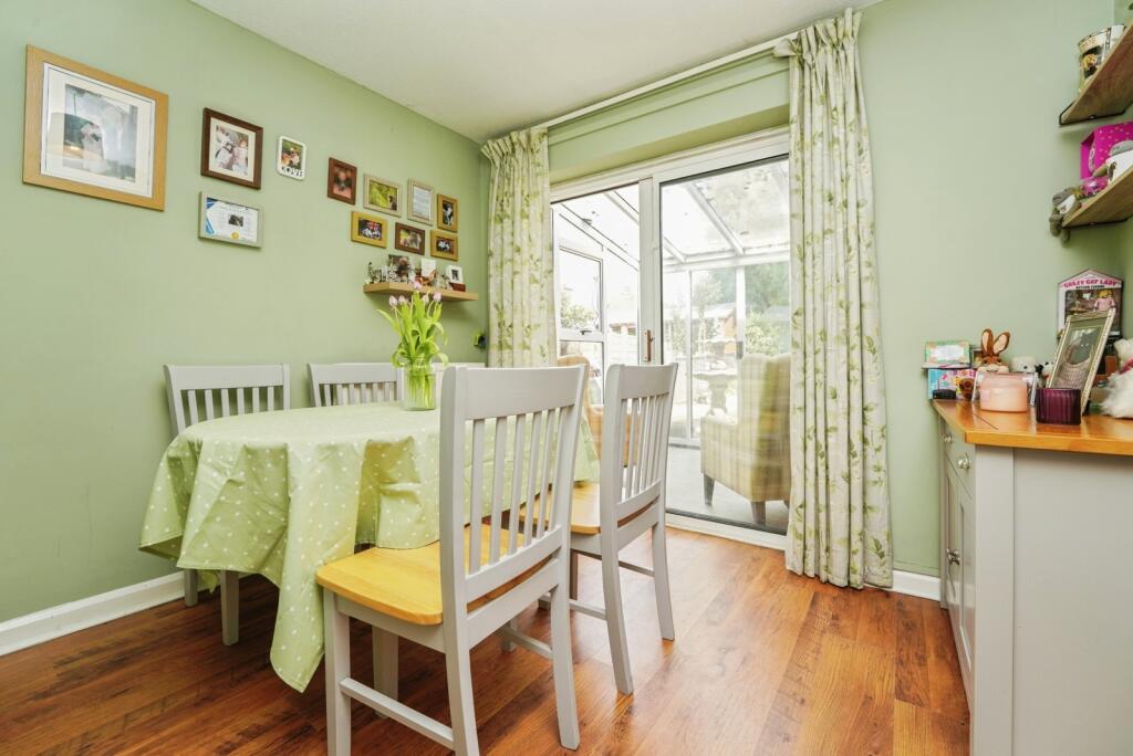
- Dining Room: small
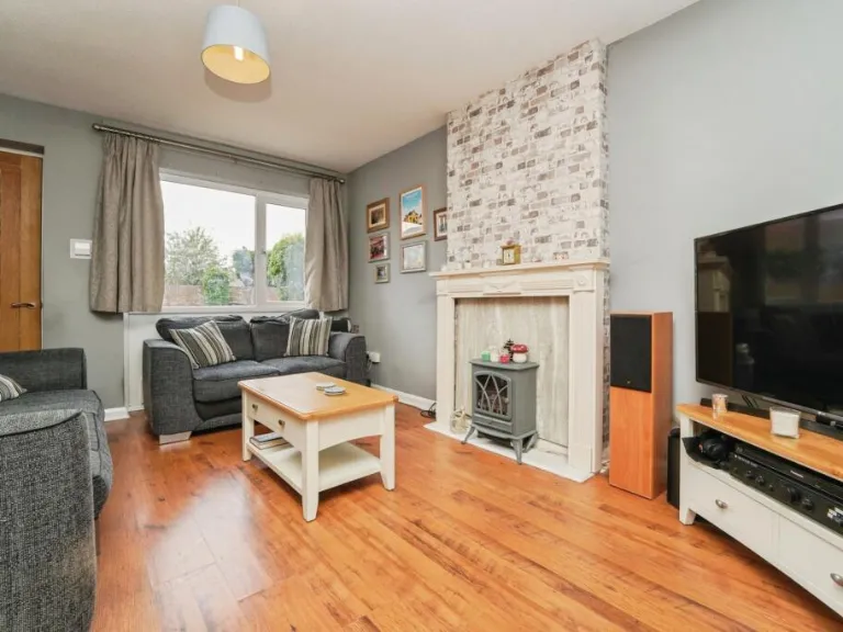
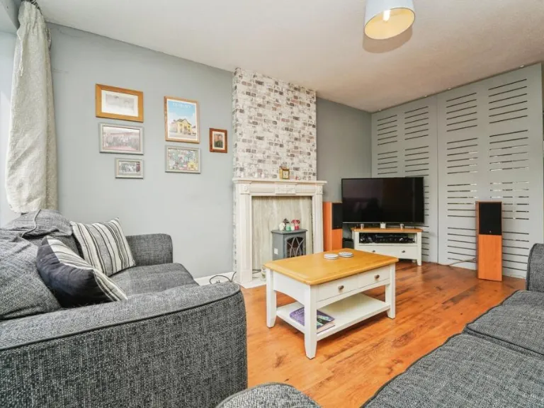
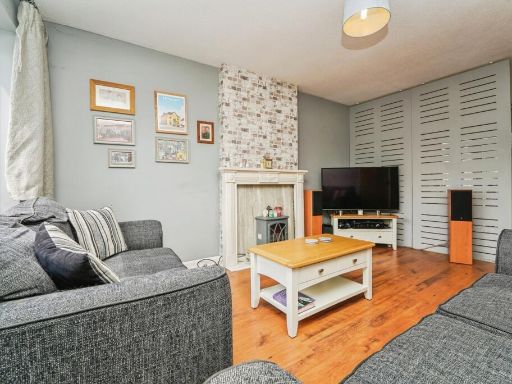
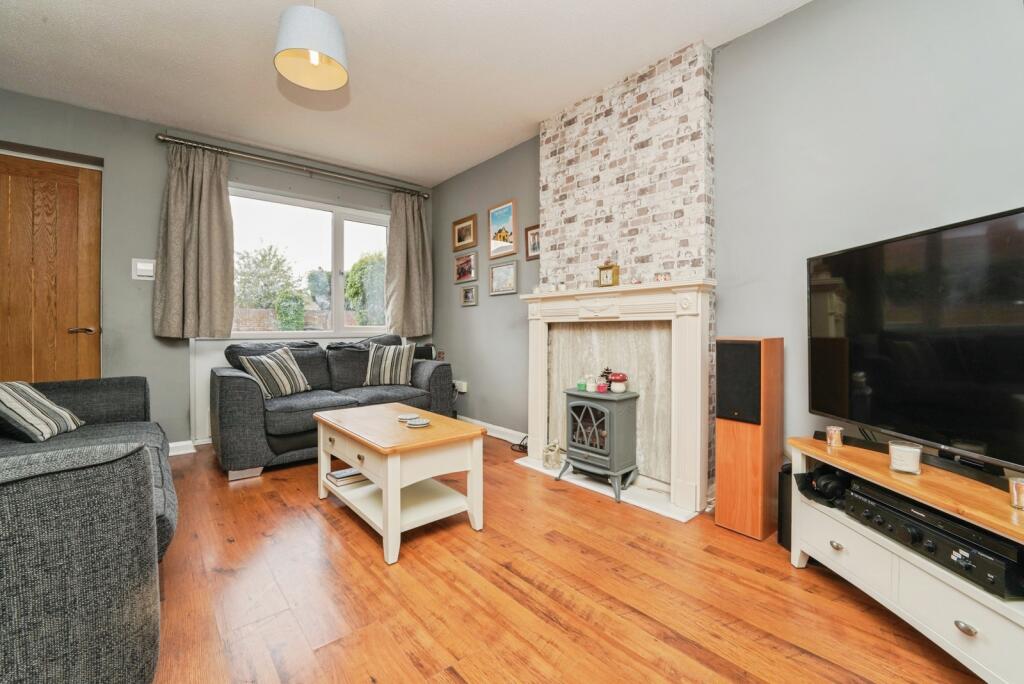
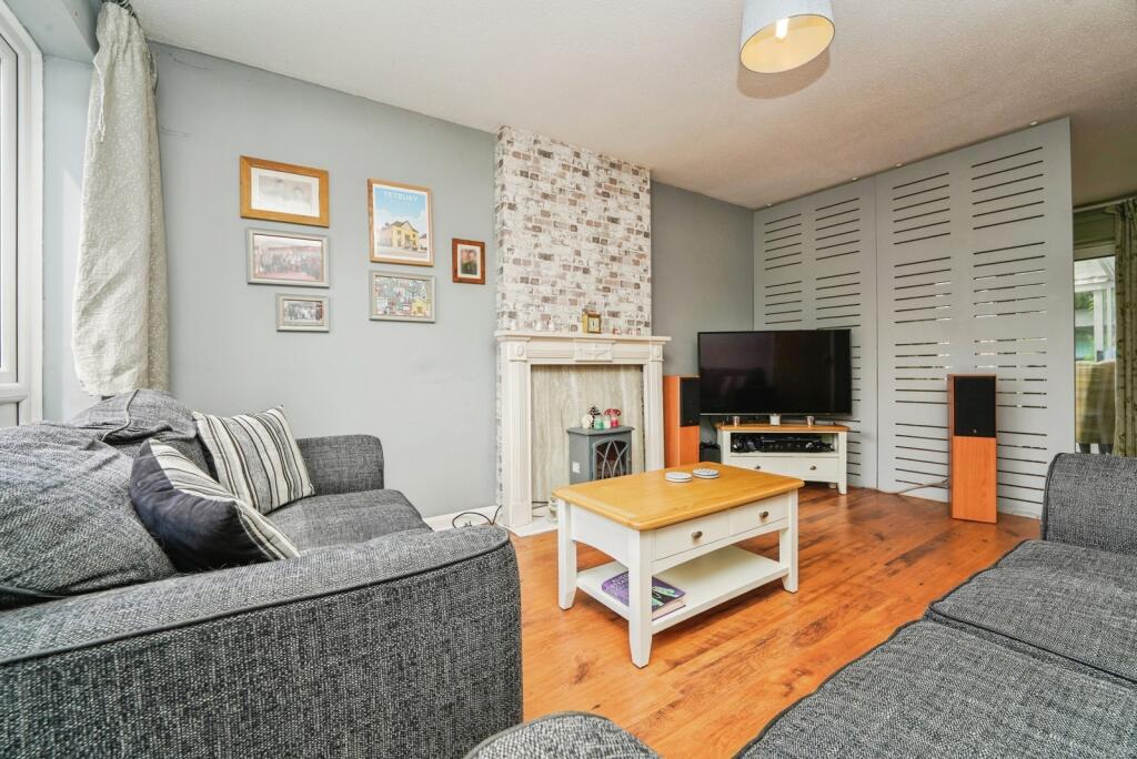
- Living Room: average
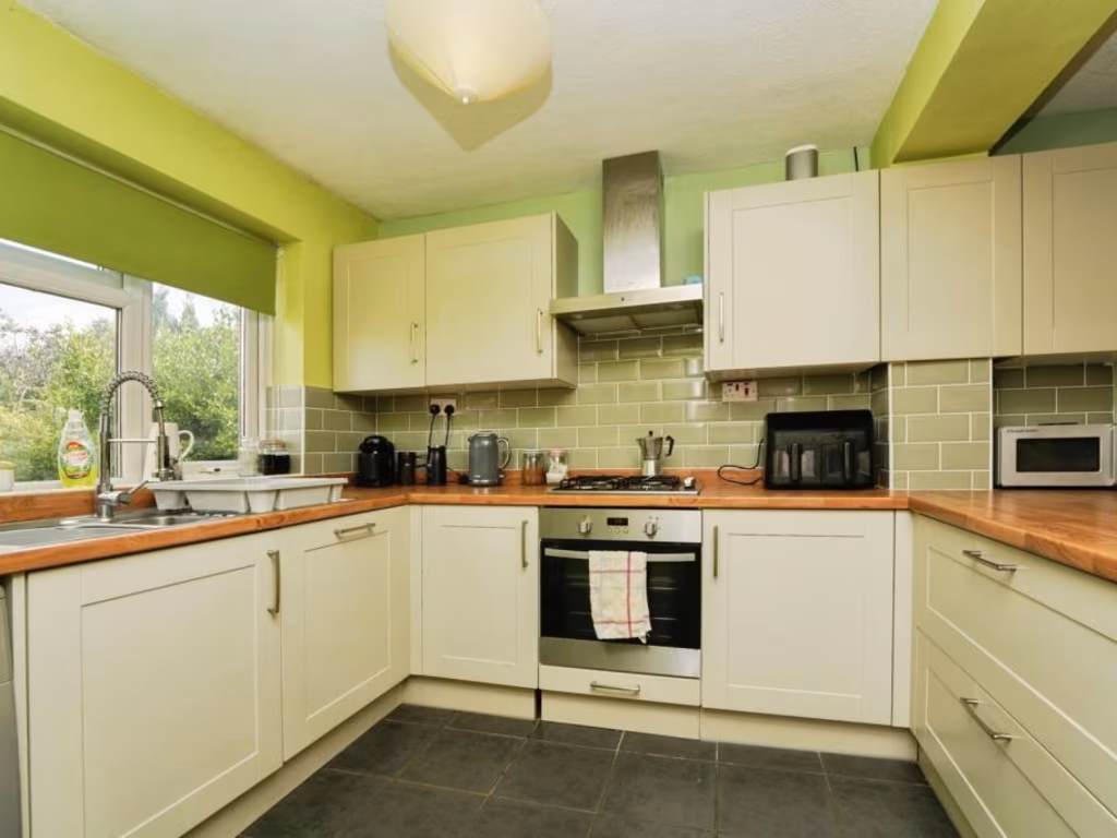
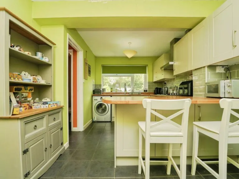
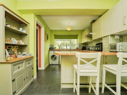
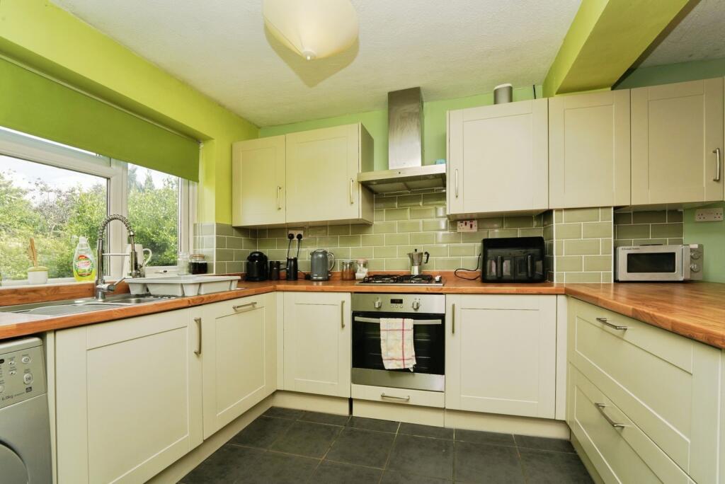
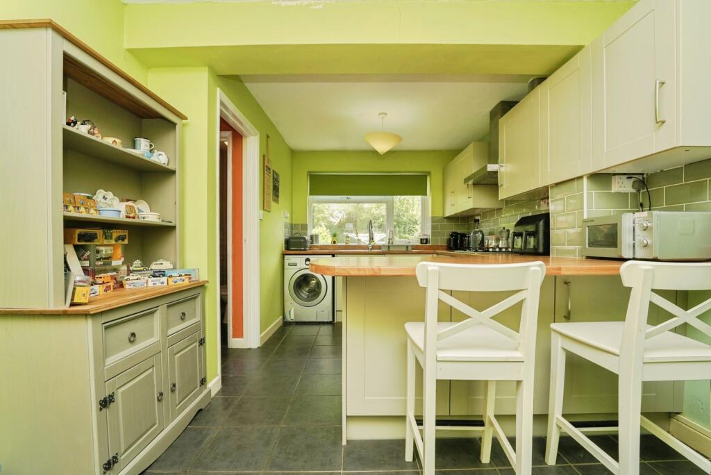
- Kitchen: average
- Garage: average
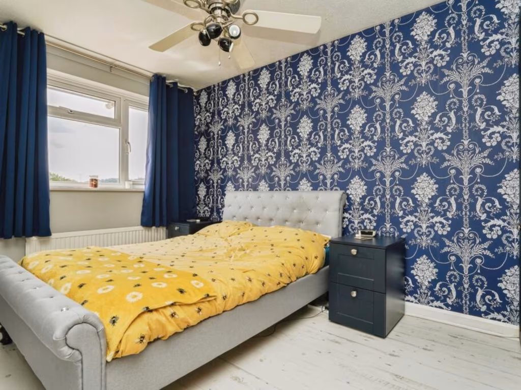
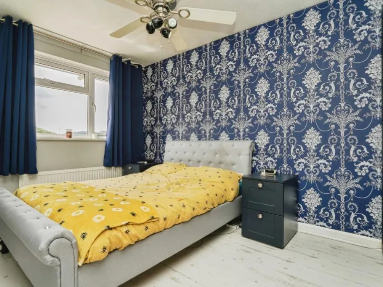
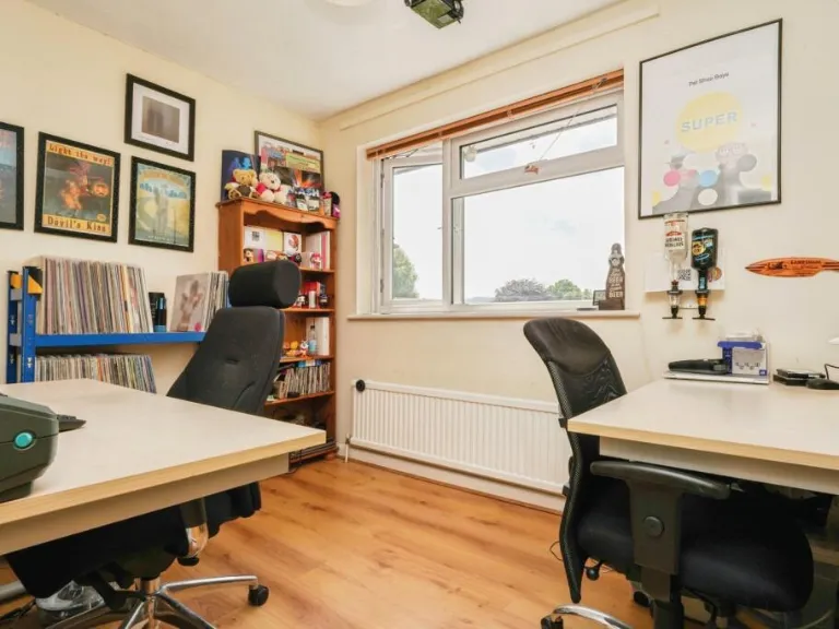
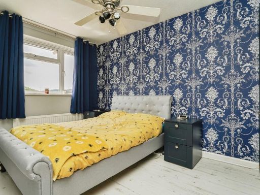
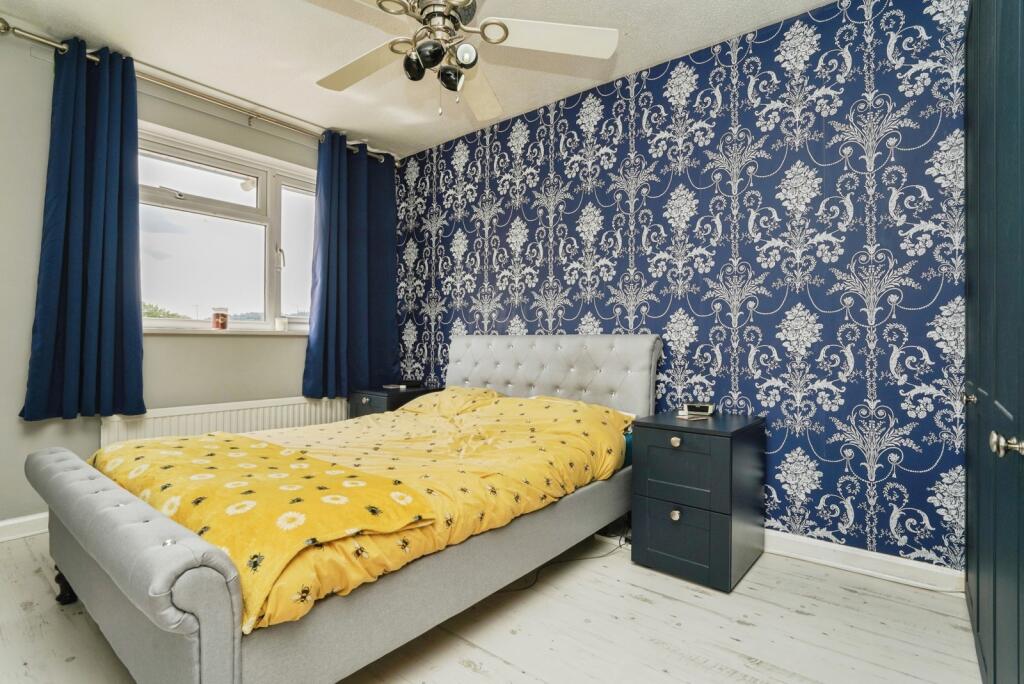
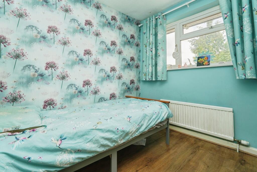
- Bedroom 1: average
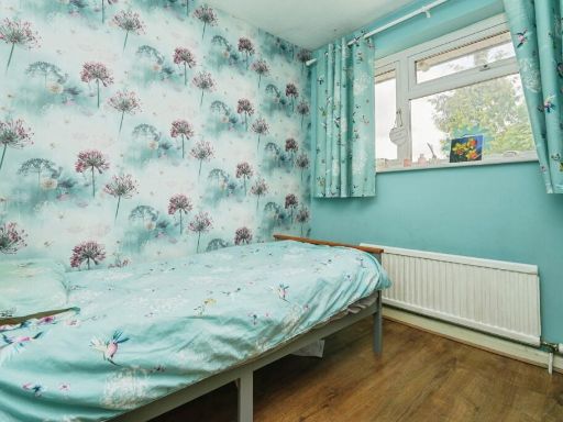
- Bedroom 2: small
- Bedroom 3: small
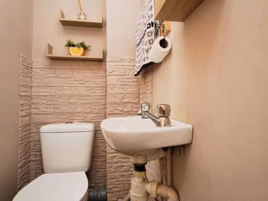
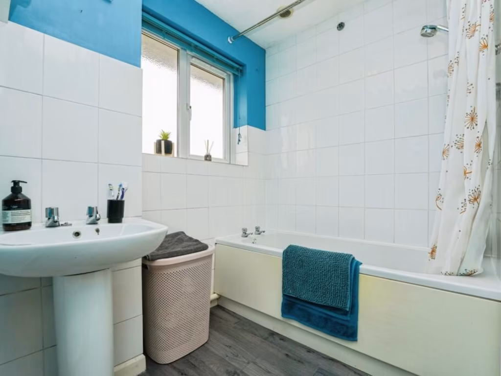
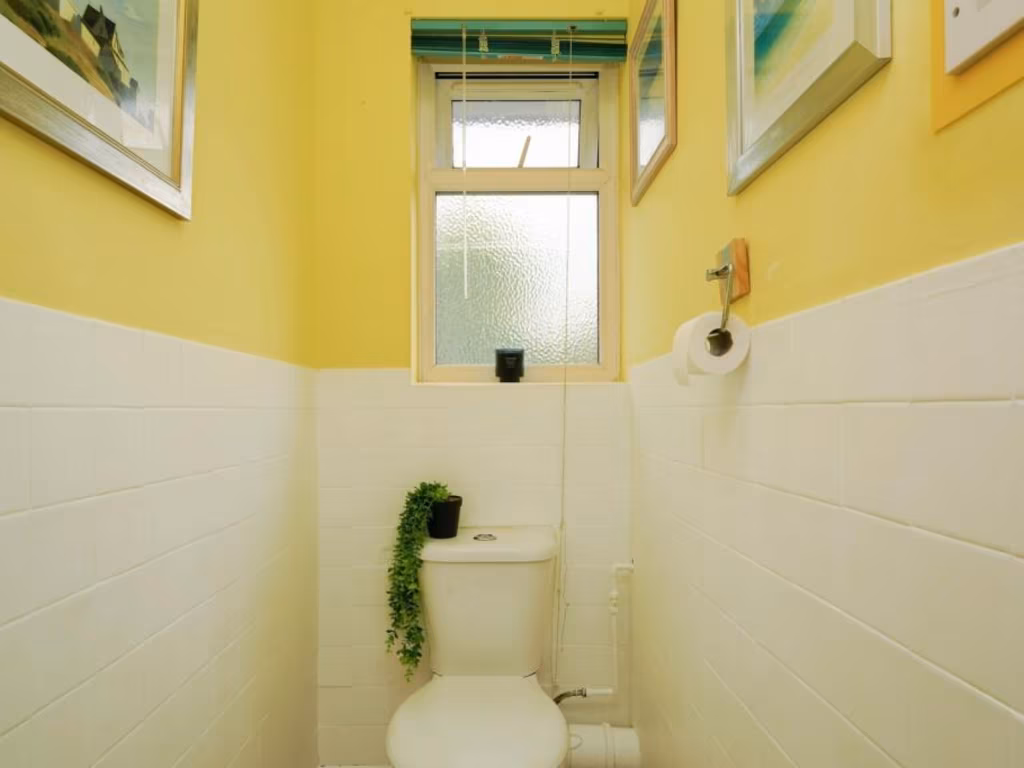
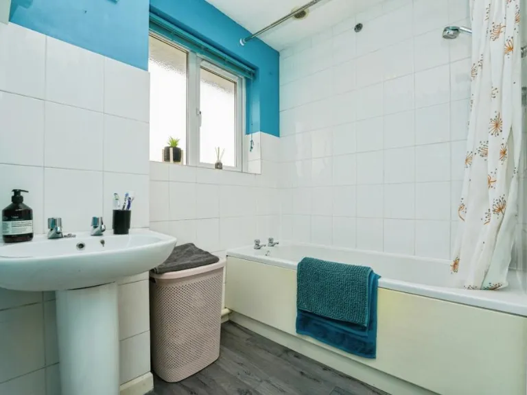
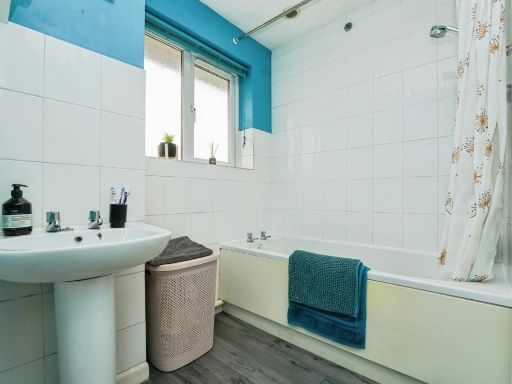
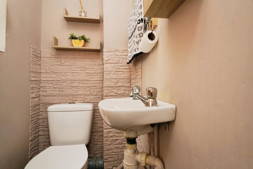
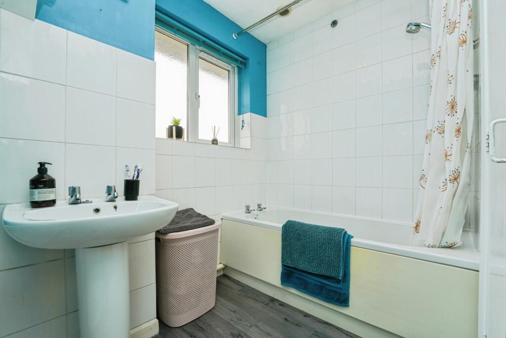
- Shower Room: small
Textual Property Features
Detected Visual Features
- semi-detached
- modern
- garage
- driveway
- red brick
- two-story
- suburban
- detached
- extended
- conservatory
- brick exterior
- garden
- residential area
- family home
EPC Details
- Fully double glazed
- Cavity wall, filled cavity
- Boiler and radiators, mains gas
- Low energy lighting in 90% of fixed outlets
- Solid, no insulation (assumed)
Nearby Schools
- Robinswood Primary Academy
- Heron Primary School
- Ribston Hall High School
- Dinglewell Infant School
- Barnwood Park School
- Barnwood Church of England Primary School
- Denmark Road High School
- Sir Thomas Rich's School
- Moat Primary Academy
- Gloucester Academy
- Abbeymead Primary School
- Finlay Community School
- Tredworth Infant and Nursery Academy
- Al Ashraf Primary School
- Al-Ashraf Secondary School for Girls
- Widden Primary School
- St Peter's Catholic Primary School
- Upton St Leonards Church of England Primary School
- Tredworth Junior School
- Dinglewell Junior School
- Hillview Primary School
- Edward Jenner School
- Longlevens Junior School
- Coney Hill Community Primary School
- Wotton House International School Gloucestershire
- Elmbridge Primary School
- Longlevens Infant School
Nearest General Shops
- Id: 9439460307
- Tags:
- TagsNormalized:
- Lat: 51.8560291
- Lon: -2.2208368
- FullGeoHash: gcnrj2ng6b2n
- PartitionGeoHash: gcnr
- Images:
- FoodStandards: null
- Distance: 761
,- Id: 9439460308
- Tags:
- TagsNormalized:
- Lat: 51.8558113
- Lon: -2.221038
- FullGeoHash: gcnrj2n9ypf5
- PartitionGeoHash: gcnr
- Images:
- FoodStandards: null
- Distance: 754.5
,- Id: 9439460309
- Tags:
- Addr:
- City: Gloucester
- Housenumber: 108
- Postcode: GL4 4LP
- Street: Eastern Avenue
- Unit: 2A
- Shop: yes
- TagsNormalized:
- Lat: 51.8552857
- Lon: -2.2216643
- FullGeoHash: gcnqvrynzmzh
- PartitionGeoHash: gcnq
- Images:
- FoodStandards: null
- Distance: 750.6
}
Nearest Grocery shops
- Id: 10298115162
- Tags:
- Brand: Premier
- Brand:wikidata: Q7240340
- Name: Harmina Stores
- Opening_hours: Mo-Sa 06:30-21:30; Su 07:30-21:30
- Shop: convenience
- TagsNormalized:
- Lat: 51.852609
- Lon: -2.2276111
- FullGeoHash: gcnqvr3zkfuu
- PartitionGeoHash: gcnq
- Images:
- FoodStandards: null
- Distance: 1021.6
,- Id: 250391633
- Tags:
- Brand: Tesco Express
- Brand:wikidata: Q98456772
- Contact:
- Website: https://www.tesco.com/store-locator/gloucester/eastern-ave
- Name: Tesco Express
- Shop: convenience
- TagsNormalized:
- tesco
- tesco express
- convenience
- shop
- Lat: 51.8494173
- Lon: -2.225796
- FullGeoHash: gcnqvqghxpyj
- PartitionGeoHash: gcnq
- Images:
- FoodStandards: null
- Distance: 909
,- Id: 9439460310
- Tags:
- Addr:
- City: Gloucester
- Housenumber: 108
- Postcode: GL4 4LP
- Street: Eastern Avenue
- Unit: 2B
- Brand: Farmfoods
- Brand:wikidata: Q5435841
- Brand:wikipedia: en:Farmfoods
- Name: Farmfoods
- Shop: frozen_food
- TagsNormalized:
- farmfoods
- frozen food
- food
- shop
- Lat: 51.8554638
- Lon: -2.2214954
- FullGeoHash: gcnqvryrgrhf
- PartitionGeoHash: gcnq
- Images:
- FoodStandards: null
- Distance: 753.4
}
Nearest Supermarkets
- Id: 235216984
- Tags:
- Alt_name: Morrisons Gloucester
- Brand: Morrisons
- Brand:wikidata: Q922344
- Brand:wikipedia: en:Morrisons
- Building: yes
- Contact:
- Website: https://my.morrisons.com/storefinder/575
- Loc_name: Morrisons Metz Way
- Name: Morrisons
- Operator: Morrisons
- Shop: supermarket
- TagsNormalized:
- Lat: 51.8607322
- Lon: -2.2223951
- FullGeoHash: gcnrj2vwwmnj
- PartitionGeoHash: gcnr
- Images:
- FoodStandards: null
- Distance: 1239.4
,- Id: 25347825
- Tags:
- Addr:
- City: Gloucester
- Country: GB
- Postcode: GL4 4FF
- Street: Heron Way
- Alt_name: Morrisons Glevum Shopping Centre
- Brand: Morrisons
- Brand:wikidata: Q922344
- Brand:wikipedia: en:Morrisons
- Name: Morrisons
- Operator: Morrisons
- Shop: supermarket
- Website: https://my.morrisons.com/storefinder/142
- TagsNormalized:
- Lat: 51.8415663
- Lon: -2.2054838
- FullGeoHash: gcnqvv6p082h
- PartitionGeoHash: gcnq
- Images:
- FoodStandards: null
- Distance: 1191.6
,- Id: 747316838
- Tags:
- Addr:
- City: Gloucester
- Postcode: GL4 4LP
- Street: Eastern Avenue
- Brand: Lidl
- Brand:wikidata: Q151954
- Brand:wikipedia: en:Lidl
- Building: retail
- Fhrs:
- Name: Lidl
- Shop: supermarket
- TagsNormalized:
- lidl
- retail
- supermarket
- shop
- Lat: 51.8546799
- Lon: -2.222479
- FullGeoHash: gcnqvrvekkzw
- PartitionGeoHash: gcnq
- Images:
- FoodStandards:
- Id: 15727
- FHRSID: 15727
- LocalAuthorityBusinessID: 05/00616/FOOD
- BusinessName: Lidl
- BusinessType: Retailers - other
- BusinessTypeID: 4613
- AddressLine1: Eastern Avenue Gloucester Gloucestershire
- AddressLine2: null
- AddressLine3: null
- AddressLine4: null
- PostCode: GL4 4LP
- RatingValue: 5
- RatingKey: fhrs_5_en-GB
- RatingDate: 2020-10-16
- LocalAuthorityCode: 127
- LocalAuthorityName: Gloucester City
- LocalAuthorityWebSite: http://www.gloucester.gov.uk
- LocalAuthorityEmailAddress: community.wellbeing@gloucester.gov.uk
- Scores:
- Hygiene: 5
- Structural: 0
- ConfidenceInManagement: 0
- NewRatingPending: false
- Geocode:
- Longitude: -2.22130000000000
- Latitude: 51.85547500000000
- Distance: 760.2
}
Nearest Religious buildings
- Id: 438545109
- Tags:
- Amenity: place_of_worship
- Building: church
- Denomination: anglican
- Description: The Parish Church of St Lawrence, Barnwood
- Name: Saint Lawrence
- Religion: christian
- Url: http://www.stlawrencebarnwood.uk.eu.org/
- Wikidata: Q17537687
- TagsNormalized:
- place of worship
- church
- anglican
- christian
- Lat: 51.8581942
- Lon: -2.2070307
- FullGeoHash: gcnrjb2zukn9
- PartitionGeoHash: gcnr
- Images:
- FoodStandards: null
- Distance: 870.7
,- Id: 726951135
- Tags:
- Amenity: place_of_worship
- Denomination: community_of_christ
- Name: Gloucester Church
- Religion: christian
- Source: OS OpenData StreetView
- Source:name: Local knowledge
- TagsNormalized:
- place of worship
- church
- christian
- Lat: 51.8518262
- Lon: -2.2172443
- FullGeoHash: gcnqvx36y2yz
- PartitionGeoHash: gcnq
- Images:
- FoodStandards: null
- Distance: 305.1
,- Id: 869076988
- Tags:
- Addr:
- City: Gloucester
- Housename: St Oswald's Church
- Postcode: GL4 4LX
- Street: Coney Hill Road
- Amenity: place_of_worship
- Building: church
- Building:levels: 1
- Denomination: anglican
- Name: St Oswald's Church, Coney Hill
- Religion: christian
- Wikidata: Q26660807
- TagsNormalized:
- place of worship
- church
- anglican
- christian
- Lat: 51.8524544
- Lon: -2.2142888
- FullGeoHash: gcnqvx7w7q4d
- PartitionGeoHash: gcnq
- Images:
- FoodStandards: null
- Distance: 164.1
}
Nearest Medical buildings
- Id: 1034892967
- Tags:
- Amenity: doctors
- Building: yes
- Healthcare: doctor
- Name: Hucclecote Surgery
- TagsNormalized:
- doctor
- doctors
- health
- healthcare
- surgery
- Lat: 51.8571657
- Lon: -2.1935456
- FullGeoHash: gcnrn069ysmf
- PartitionGeoHash: gcnr
- Images:
- FoodStandards: null
- Distance: 1482.9
,- Id: 1205506312
- Tags:
- Amenity: health_centre
- Healthcare: centre
- TagsNormalized:
- health
- health centre
- healthcare
- Lat: 51.8394019
- Lon: -2.2052554
- FullGeoHash: gcnqvv44mufm
- PartitionGeoHash: gcnq
- Images:
- FoodStandards: null
- Distance: 1418.7
,- Id: 747402049
- Tags:
- Addr:
- City: Gloucester
- Postcode: GL4 4BL
- Street: Glevum Way
- Amenity: doctors
- Building: yes
- Healthcare: doctor
- Name: Hadwen Medical Practice
- Operator: Hadwen Medical Practice
- TagsNormalized:
- doctor
- doctors
- health
- healthcare
- Lat: 51.8415545
- Lon: -2.203875
- FullGeoHash: gcnqvv7nvypw
- PartitionGeoHash: gcnq
- Images:
- FoodStandards: null
- Distance: 1244
,- Id: 104495020
- Tags:
- Addr:
- City: Gloucester
- Housename: Glevum Way Surgery
- Postcode: GL4 4BL
- Street: Glevum Way
- Amenity: pharmacy
- Building: yes
- Dispensing: yes
- Drive_through: no
- Healthcare: pharmacy
- Name: Glevum Pharmacy
- Operator: Glevum Pharmacy
- TagsNormalized:
- Lat: 51.8414844
- Lon: -2.2042222
- FullGeoHash: gcnqvv6ytchu
- PartitionGeoHash: gcnq
- Images:
- FoodStandards: null
- Distance: 1239.1
}
Nearest Leisure Facilities
- Id: 157076644
- Tags:
- Leisure: park
- Name: Coney Hill Park
- Source: Bing and Local Knowledge
- TagsNormalized:
- Lat: 51.8550781
- Lon: -2.2138221
- FullGeoHash: gcnqvxgvwpnt
- PartitionGeoHash: gcnq
- Images:
- FoodStandards: null
- Distance: 429.9
,- Id: 164674483
- Tags:
- TagsNormalized:
- Lat: 51.8532201
- Lon: -2.2083709
- FullGeoHash: gcnqvxxfvhz6
- PartitionGeoHash: gcnq
- Images:
- FoodStandards: null
- Distance: 380.2
,- Id: 134914235
- Tags:
- Leisure: park
- Name: Birch Avenue Open Space
- Source: council web site
- TagsNormalized:
- Lat: 51.8510922
- Lon: -2.2183883
- FullGeoHash: gcnqvx0web1u
- PartitionGeoHash: gcnq
- Images:
- FoodStandards: null
- Distance: 377.4
,- Id: 1594621395
- Tags:
- Leisure: playground
- Source: Local knowledge
- TagsNormalized:
- Lat: 51.8510154
- Lon: -2.2181843
- FullGeoHash: gcnqvx0y09cf
- PartitionGeoHash: gcnq
- Images:
- FoodStandards: null
- Distance: 363.9
,- Id: 1693112287
- Tags:
- Leisure: playground
- Source: Local knowledge
- TagsNormalized:
- Lat: 51.8542864
- Lon: -2.213355
- FullGeoHash: gcnqvxu315dg
- PartitionGeoHash: gcnq
- Images:
- FoodStandards: null
- Distance: 338.6
}
Nearest Tourist attractions
- Id: 2701765847
- Tags:
- Addr:
- City: Gloucester
- Housenumber: Bond End Farm
- Postcode: GL4 8ED
- Street: Bondend Lane
- Suburb: Upton St Leonards
- Email: shamba.barn@gmail.com
- Name: Shamba Barn
- Operator: Bond End Farm
- Phone: +44 7714 022023
- Tourism: chalet
- Website: http://www.homeaway.co.uk/p1611714#summary
- TagsNormalized:
- Lat: 51.8351281
- Lon: -2.1912477
- FullGeoHash: gcnqyhk3s0pr
- PartitionGeoHash: gcnq
- Images:
- FoodStandards: null
- Distance: 2329.8
,- Id: 30847305
- Tags:
- Name: Robinswood Hill Rare Breeds Farm
- Tourism: attraction
- TagsNormalized:
- Lat: 51.8398232
- Lon: -2.2391184
- FullGeoHash: gcnqvj1sbg2q
- PartitionGeoHash: gcnq
- Images:
- FoodStandards: null
- Distance: 2204.4
,- Id: 365284652
- Tags:
- Addr:
- City: Gloucester
- Housenumber: 23
- Postcode: GL1 4NG
- Street: Albany Street
- Name: Saint James City Farm
- Phone: +44 1452 305728
- Tourism: attraction
- Website: www.stjamescityfarm.co.uk
- TagsNormalized:
- Lat: 51.8560918
- Lon: -2.2338261
- FullGeoHash: gcnrj0j7sh4s
- PartitionGeoHash: gcnr
- Images:
- FoodStandards: null
- Distance: 1534.6
}
Nearest Train stations
- Id: 5520072621
- Tags:
- Name: Ashchurch
- Naptan:
- Network: National Rail
- Public_transport: station
- Railway: station
- Ref:
- Source: NPE
- Wikipedia: en:Ashchurch for Tewkesbury railway station
- TagsNormalized:
- Lat: 51.9990255
- Lon: -2.1087299
- FullGeoHash: gcnxb40kr0cj
- PartitionGeoHash: gcnx
- Images:
- FoodStandards: null
- Distance: 17917
,- Id: 1592883651
- Tags:
- Name: Gotherington
- Naptan:
- Operator: Gloucestershire and Warwickshire Steam Railway
- Public_transport: station
- Railway: station
- Source: Bing;local_knowledge
- Usage: tourism
- Wikidata: Q5587849
- TagsNormalized:
- Lat: 51.9672114
- Lon: -2.0380294
- FullGeoHash: gcnx9s7fyqr4
- PartitionGeoHash: gcnx
- Images:
- FoodStandards: null
- Distance: 17611
,- Id: 15825263
- Tags:
- Name: Cheltenham Racecourse
- Naptan:
- Operator: Gloucestershire and Warwickshire Steam Railway
- Public_transport: station
- Railway: station
- Source: npe
- Usage: tourism
- Wikidata: Q5090223
- Wikipedia: en:Cheltenham Racecourse railway station
- TagsNormalized:
- Lat: 51.9243306
- Lon: -2.0678139
- FullGeoHash: gcnx2uw30ky0
- PartitionGeoHash: gcnx
- Images:
- FoodStandards: null
- Distance: 12852
,- Id: 7154294070
- Tags:
- Addr:
- City: Cheltenham
- Postcode: GL51 8NP
- Street: Queens Road
- Name: Cheltenham Spa
- Naptan:
- Network: National Rail
- Old_name: Cheltenham Spa (Lansdown)
- Operator: First Great Western
- Public_transport: station
- Railway: station
- Ref:
- Source: Bing
- Wheelchair: yes
- Wikipedia: en:Cheltenham Spa railway station
- TagsNormalized:
- Lat: 51.8969882
- Lon: -2.1001222
- FullGeoHash: gcnx0pw9zeg3
- PartitionGeoHash: gcnx
- Images:
- FoodStandards: null
- Distance: 9263.1
,- Id: 6646199707
- Tags:
- Name: Gloucester
- Naptan:
- Network: National Rail
- Operator: Great Western Railway
- Postal_code: GL1 1DE
- Public_transport: station
- Railway: station
- Ref:
- Wheelchair: yes
- Wikipedia: en:Gloucester railway station
- TagsNormalized:
- Lat: 51.8655109
- Lon: -2.2382438
- FullGeoHash: gcnrj1f4mpur
- PartitionGeoHash: gcnr
- Images:
- FoodStandards: null
- Distance: 2354.2
}
Nearest Hotels
- Id: 59011640
- Tags:
- Addr:
- City: Gloucester
- Postcode: GL4 3RX
- Brand: Holiday Inn
- Brand:wikidata: Q2717882
- Brand:wikipedia: en:Holiday Inn
- Building: yes
- Name: Holiday Inn Barnwood
- Source: OS_OpenData_StreetView & Local Knowledge
- Tourism: hotel
- TagsNormalized:
- Lat: 51.8640867
- Lon: -2.1937898
- FullGeoHash: gcnrn1dd0yxb
- PartitionGeoHash: gcnr
- Images:
- FoodStandards: null
- Distance: 1938.7
,- Id: 272039303
- Tags:
- Addr:
- City: Gloucester
- Postcode: GL4 6EA
- Building: hotel
- Name: Hallmark Hotel
- Operator: Hallmark
- Tourism: hotel
- Url: http://www.hallmarkhotels.co.uk/
- TagsNormalized:
- Lat: 51.8356266
- Lon: -2.2194799
- FullGeoHash: gcnqvkru6m5u
- PartitionGeoHash: gcnq
- Images:
- FoodStandards: null
- Distance: 1795.5
,- Id: 144934840
- Tags:
- Addr:
- City: Gloucester
- Parentstreet: Corinium Avenue
- Postcode: GL4 3DG
- Street: Sawmills End
- Brand: Ibis
- Brand:wikidata: Q920166
- Building: hotel
- Name: Ibis Gloucester
- Source: survey
- Tourism: hotel
- Website: http://www.ibis.com/gb/hotel-6900-ibis-gloucester/
- TagsNormalized:
- Lat: 51.8648468
- Lon: -2.211067
- FullGeoHash: gcnrj9tywkhy
- PartitionGeoHash: gcnr
- Images:
- FoodStandards: null
- Distance: 1516.7
}
Tags
- semi-detached
- modern
- garage
- driveway
- red brick
- two-story
- suburban
- modern
- suburban
- detached
- extended
- two-story
- conservatory
- brick exterior
- garden
- residential area
- family home
Local Market Stats
- Average Price/sqft: £287
- Avg Income: £46700
- Rental Yield: 4.9%
- Social Housing: 7%
- Planning Success Rate: 82%
Similar Properties
 3 bedroom semi-detached house for sale in Swift Road, Abbeydale, Gloucester, Gloucestershire, GL4 — £270,000 • 3 bed • 1 bath • 791 ft²
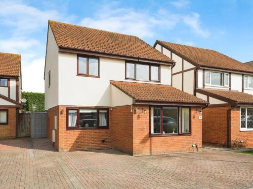 4 bedroom detached house for sale in Ashton Close, Abbeydale, Gloucester, Gloucestershire, GL4 — £375,000 • 4 bed • 2 bath • 1026 ft²
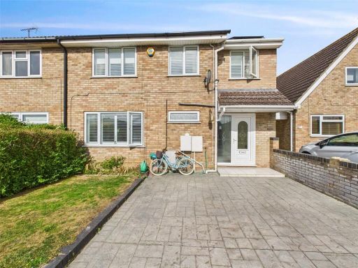 4 bedroom semi-detached house for sale in Jaythorpe, Abbeydale, Gloucester, Gloucestershire, GL4 — £375,000 • 4 bed • 3 bath • 1491 ft²
 4 bedroom link detached house for sale in Oriole Way, Abbeydale, Gloucester, GL4 — £365,000 • 4 bed • 1 bath • 1119 ft²
 3 bedroom detached house for sale in Cox's Way, Abbeymead, Gloucester, Gloucestershire, GL4 — £325,000 • 3 bed • 2 bath • 980 ft²
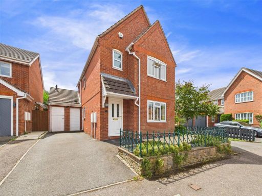 3 bedroom detached house for sale in Prices Ground, Abbeymead, Gloucester, Gloucestershire, GL4 — £350,000 • 3 bed • 2 bath • 1079 ft²
Meta
- {
"@context": "https://schema.org",
"@type": "Residence",
"name": "3 bedroom detached house for sale in Tern Close, Abbeydale,…",
"description": "",
"url": "https://propertypiper.co.uk/property/60a3ce3c-1864-4f96-8e64-890256fe81e4",
"image": "https://image-a.propertypiper.co.uk/3bc4354c-314d-41ba-8ee8-f4ed94408a9b-1024.jpeg",
"address": {
"@type": "PostalAddress",
"streetAddress": "6 TERN CLOSE ABBEYDALE GLOUCESTER",
"postalCode": "GL4 4WQ",
"addressLocality": "Gloucester",
"addressRegion": "Gloucester",
"addressCountry": "England"
},
"geo": {
"@type": "GeoCoordinates",
"latitude": 51.851254,
"longitude": -2.2128999
},
"numberOfRooms": 3,
"numberOfBathroomsTotal": 2,
"floorSize": {
"@type": "QuantitativeValue",
"value": 1150,
"unitCode": "FTK"
},
"offers": {
"@type": "Offer",
"price": 325000,
"priceCurrency": "GBP",
"availability": "https://schema.org/InStock"
},
"additionalProperty": [
{
"@type": "PropertyValue",
"name": "Feature",
"value": "semi-detached"
},
{
"@type": "PropertyValue",
"name": "Feature",
"value": "modern"
},
{
"@type": "PropertyValue",
"name": "Feature",
"value": "garage"
},
{
"@type": "PropertyValue",
"name": "Feature",
"value": "driveway"
},
{
"@type": "PropertyValue",
"name": "Feature",
"value": "red brick"
},
{
"@type": "PropertyValue",
"name": "Feature",
"value": "two-story"
},
{
"@type": "PropertyValue",
"name": "Feature",
"value": "suburban"
},
{
"@type": "PropertyValue",
"name": "Feature",
"value": "modern"
},
{
"@type": "PropertyValue",
"name": "Feature",
"value": "suburban"
},
{
"@type": "PropertyValue",
"name": "Feature",
"value": "detached"
},
{
"@type": "PropertyValue",
"name": "Feature",
"value": "extended"
},
{
"@type": "PropertyValue",
"name": "Feature",
"value": "two-story"
},
{
"@type": "PropertyValue",
"name": "Feature",
"value": "conservatory"
},
{
"@type": "PropertyValue",
"name": "Feature",
"value": "brick exterior"
},
{
"@type": "PropertyValue",
"name": "Feature",
"value": "garden"
},
{
"@type": "PropertyValue",
"name": "Feature",
"value": "residential area"
},
{
"@type": "PropertyValue",
"name": "Feature",
"value": "family home"
}
]
}
High Res Floorplan Images
Compatible Floorplan Images
FloorplanImages Thumbnail