PL21 0BS - 4 bedroom detached house for sale in Crescent Gardens, Ivyb…
View on Property Piper
4 bedroom detached house for sale in Crescent Gardens, Ivybridge, Devon, PL21
Property Details
- Price: £435000
- Bedrooms: 4
- Bathrooms: 2
- Property Type: undefined
- Property SubType: undefined
Brochure Descriptions
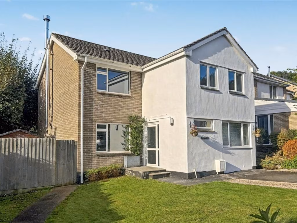
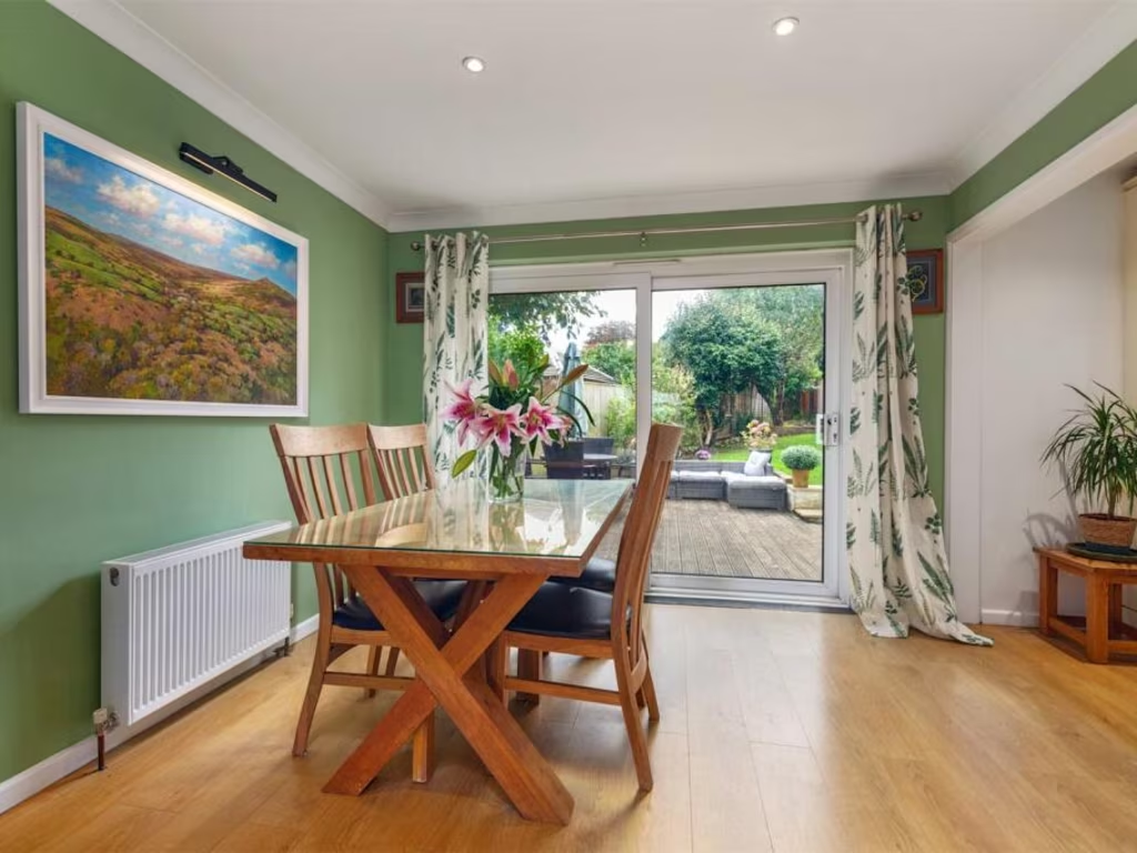
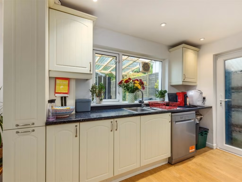
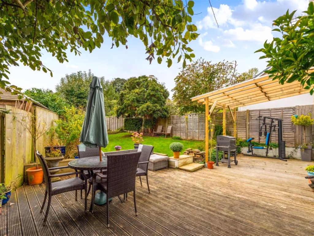
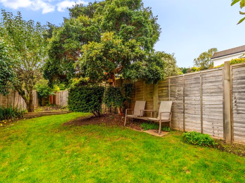
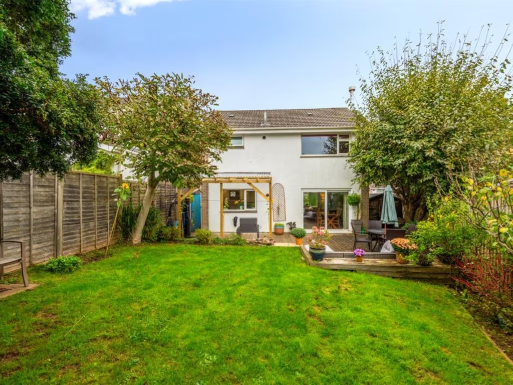
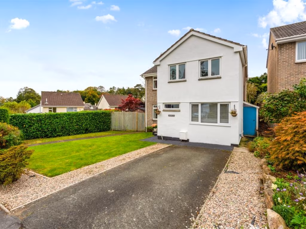
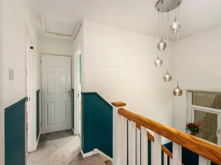
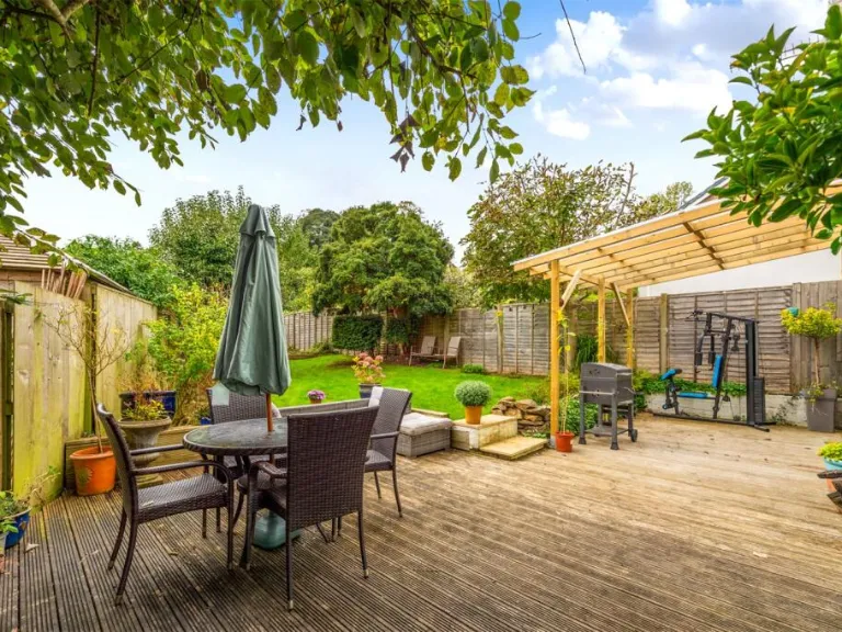
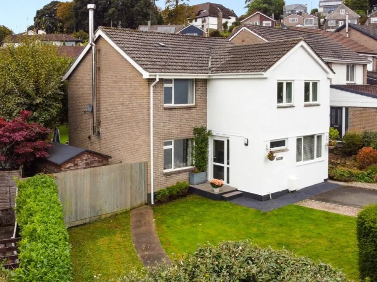
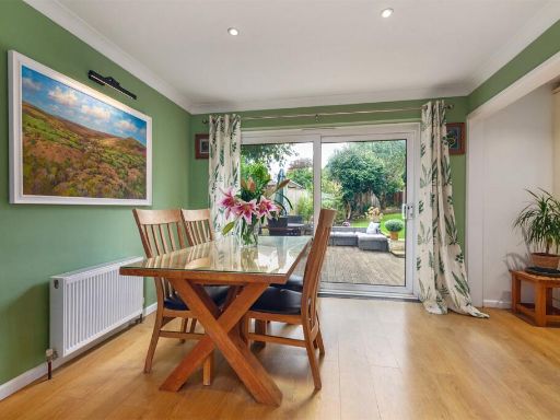
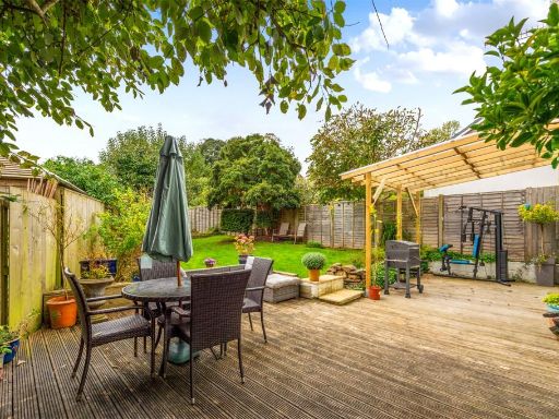
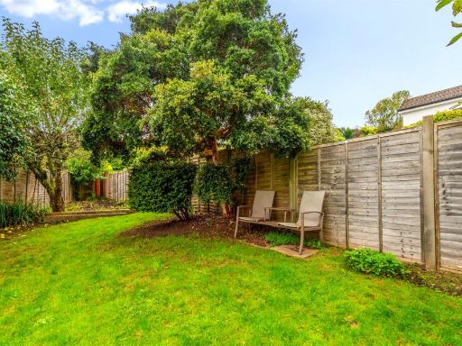
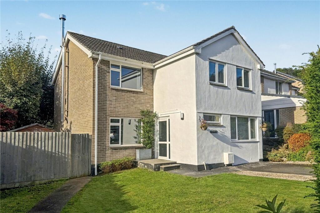
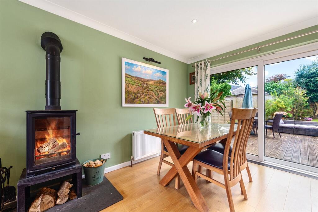
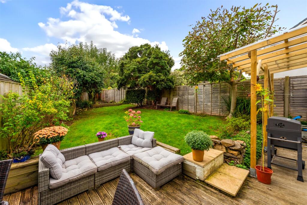
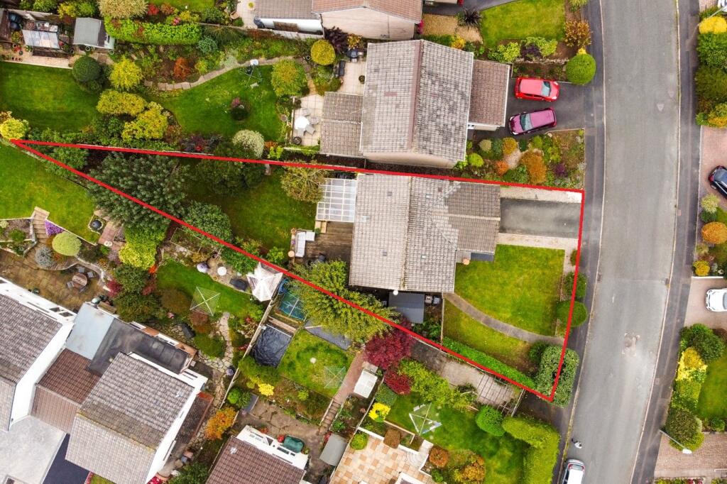
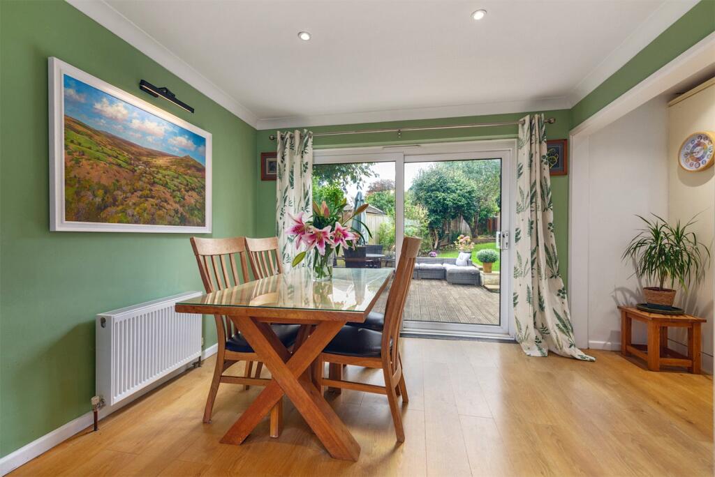
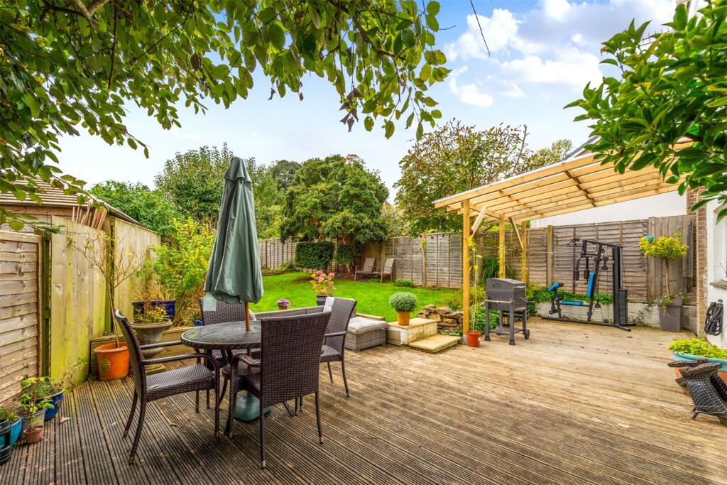
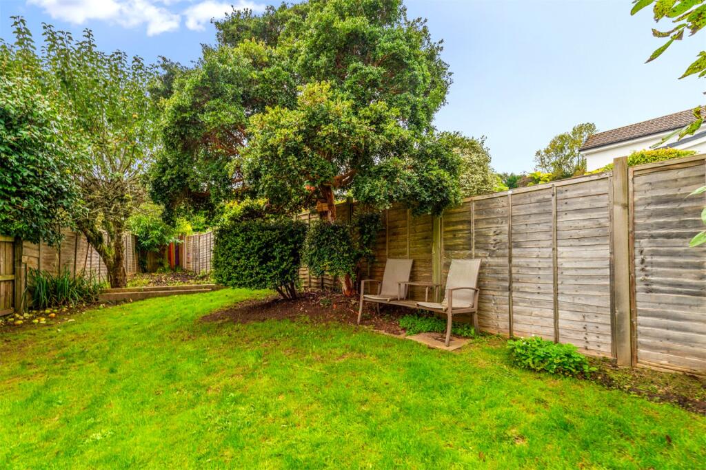
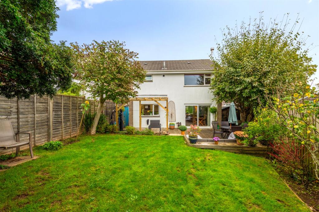
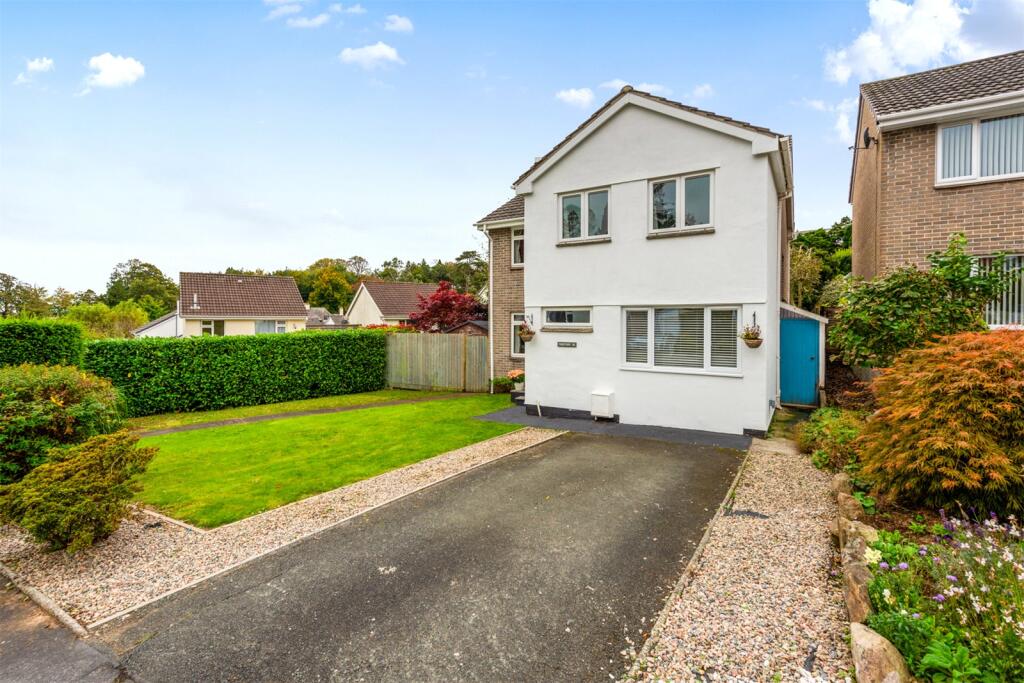
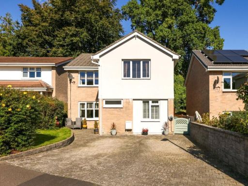
- Detached two-storey house on Crescent Gardens in Ivybridge. The property presents a rendered and brick exterior with a private front lawn and mature hedging providing good privacy. It appears to sit on a generous plot with a paved path to the entrance, planted borders and space at the side that could provide additional parking or a side garden. The garden is large for a suburban plot and the overall property footprint is medium — a typical family house offering multiple reception rooms and first-floor bedrooms (exact internal layout not shown). The setting is residential/suburban with pleasant garden outlooks; no exceptional water, sea or city views are visible.
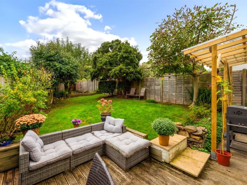
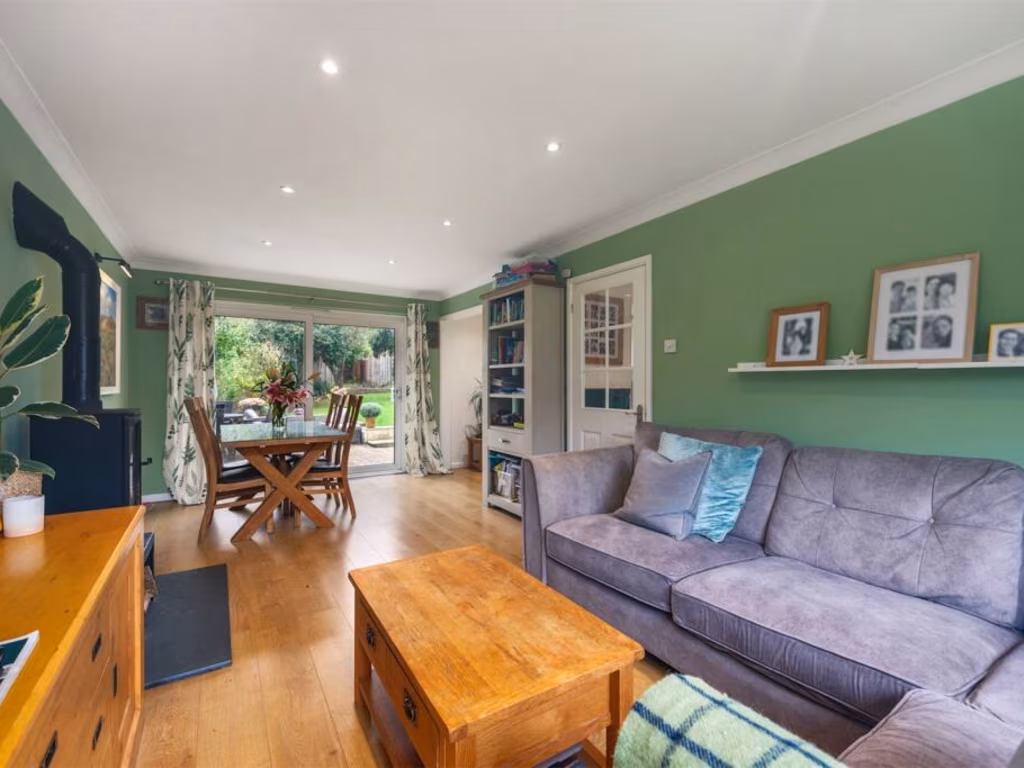
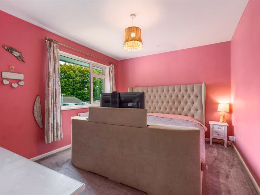
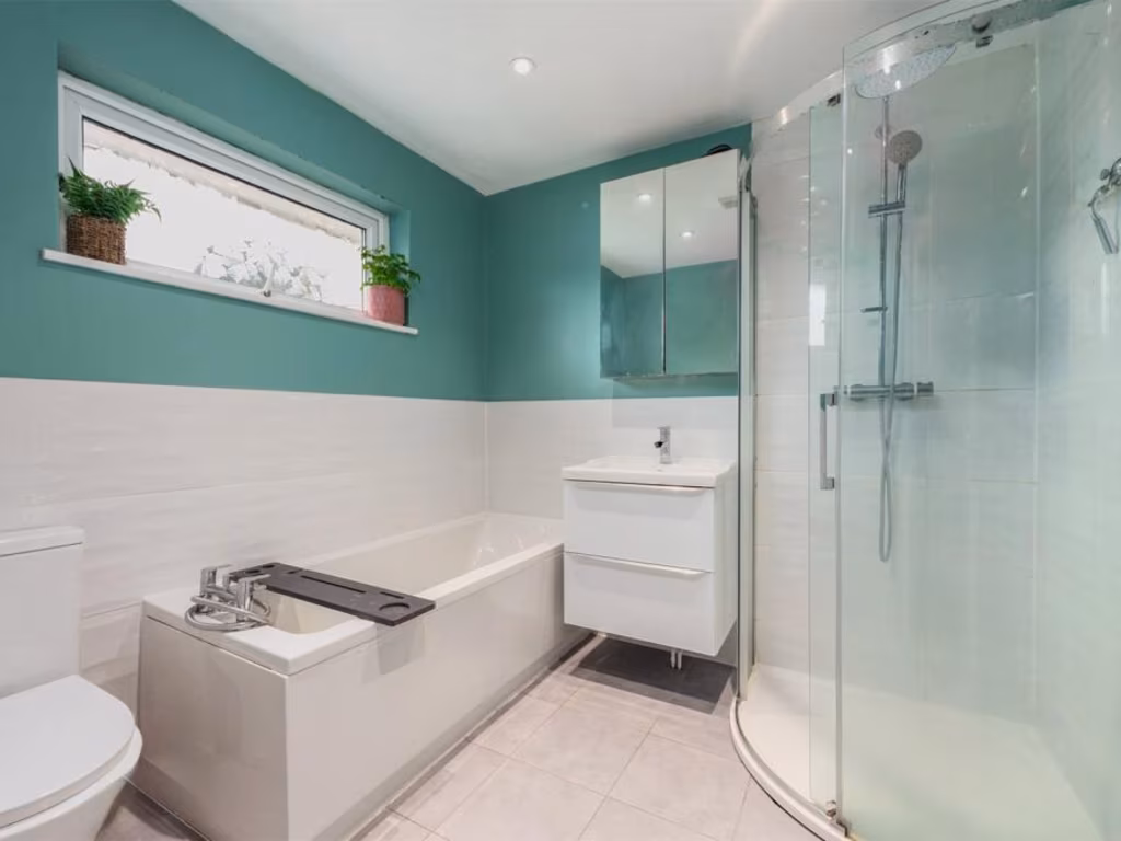
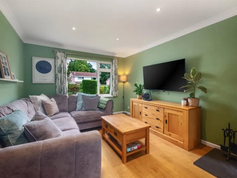
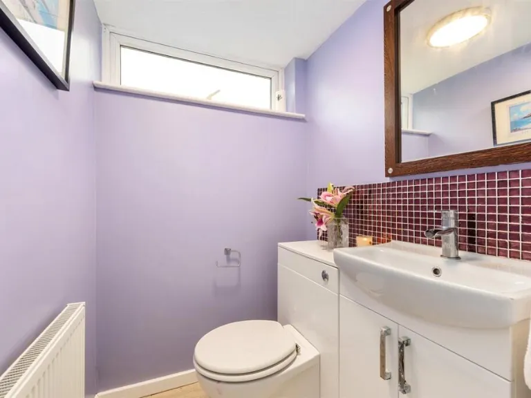
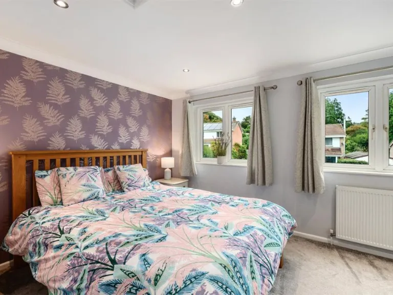
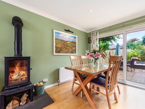
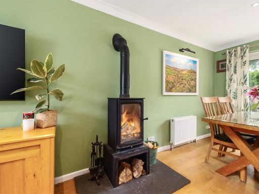
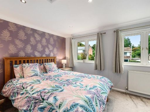
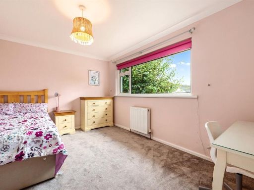
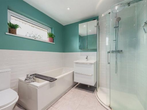
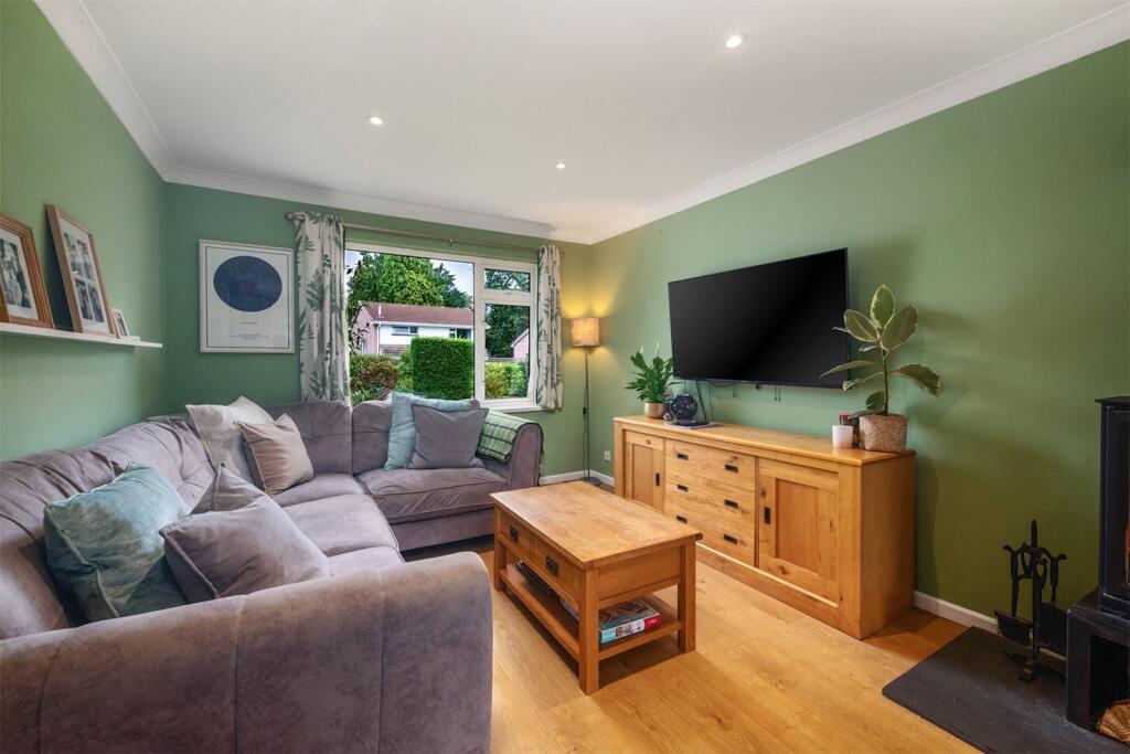
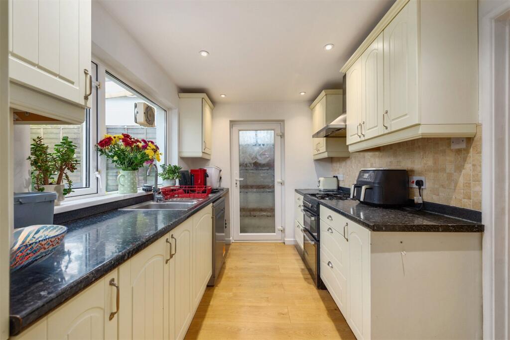
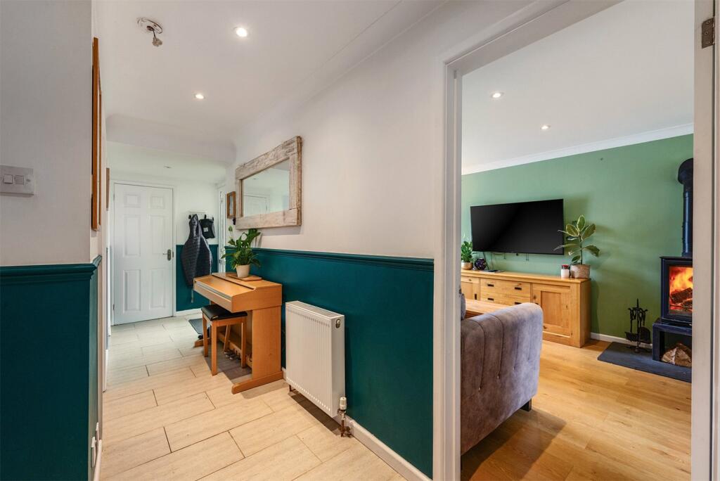
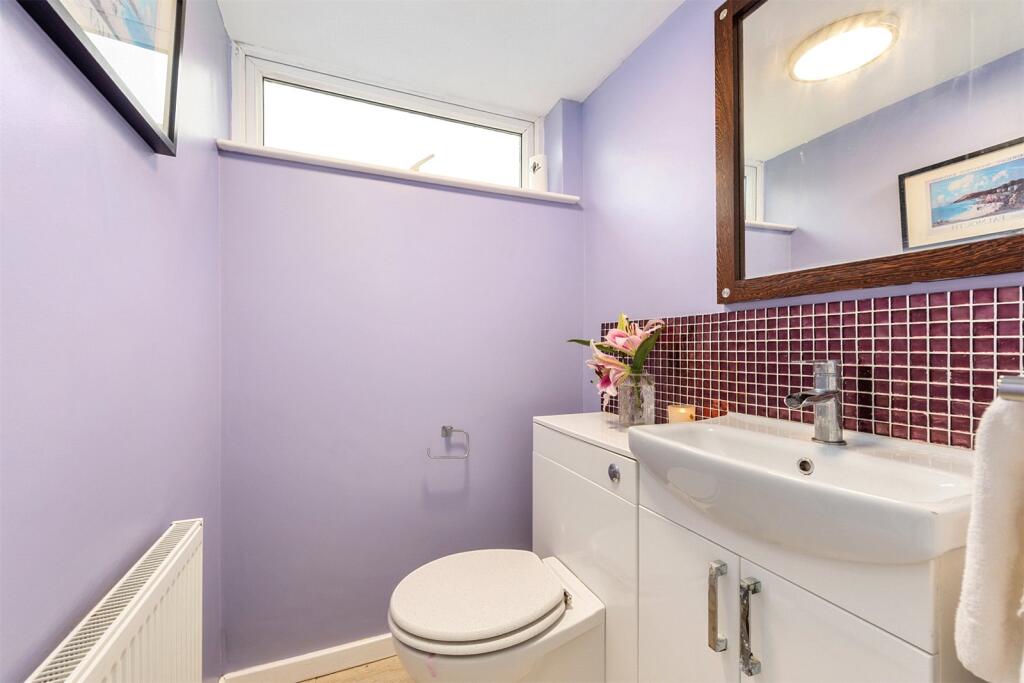
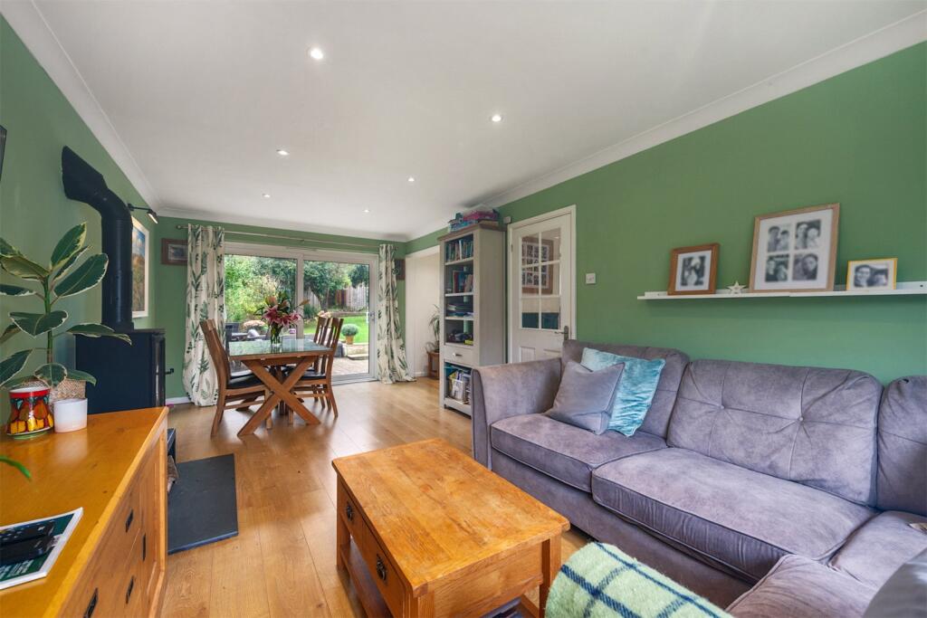
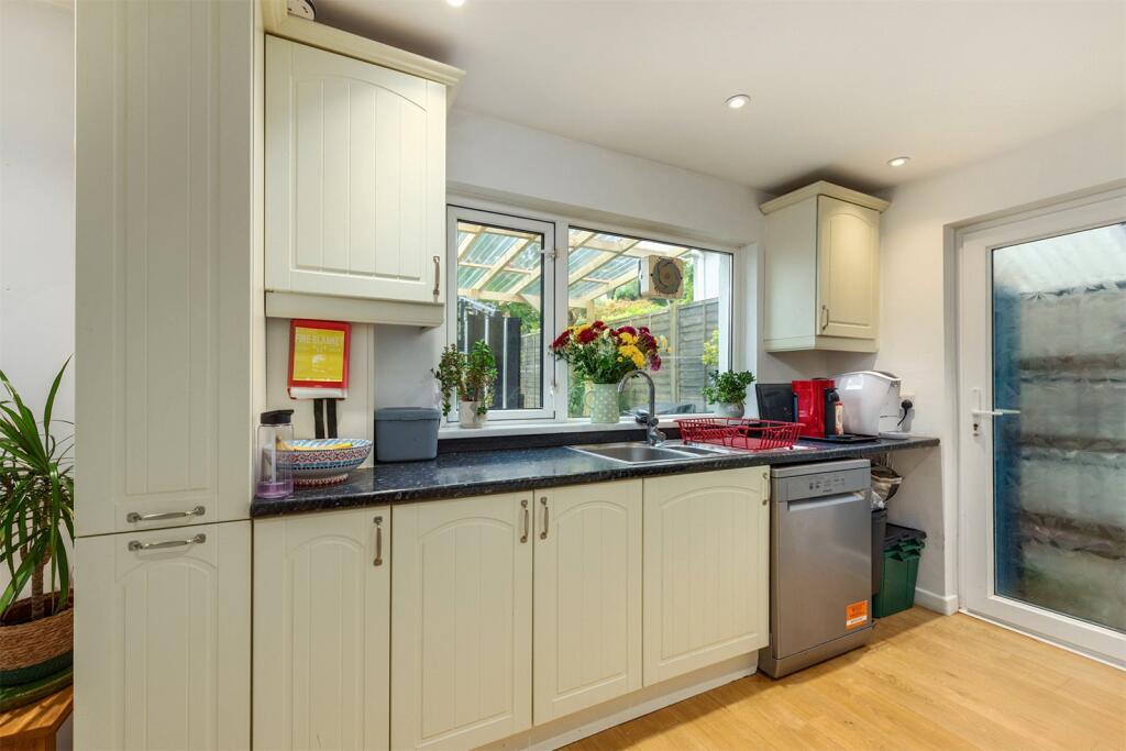
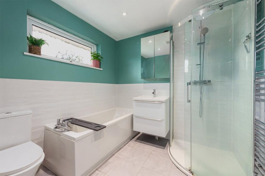
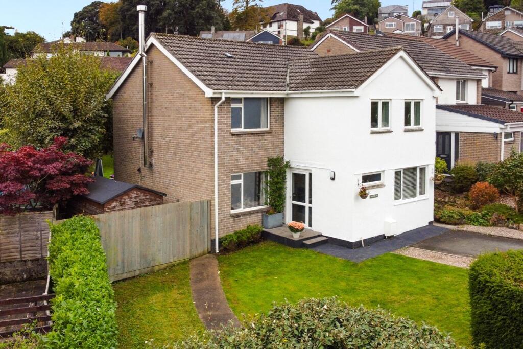
- Mid‑sized, modern family house presented to a good standard. Photographs show a two‑storey dwelling with a well‑proportioned, deep rear garden and decking area, mature boundary planting and private feel (large rear garden). Interior images indicate at least two double bedrooms (bright, average‑sized bedrooms) and a fully fitted contemporary bathroom with separate bath and shower. Overall accommodation appears suited to a 3‑bed family home with average internal room sizes and good outdoor amenity. The property benefits from a generous, private rear garden (large) and usable outdoor entertaining space (decking). Overall property size: medium (typical family house footprint), well maintained and ready for occupation. No definitive total square footage or full address for the residential property is visible in the images provided.
Image Descriptions
- house exterior modern
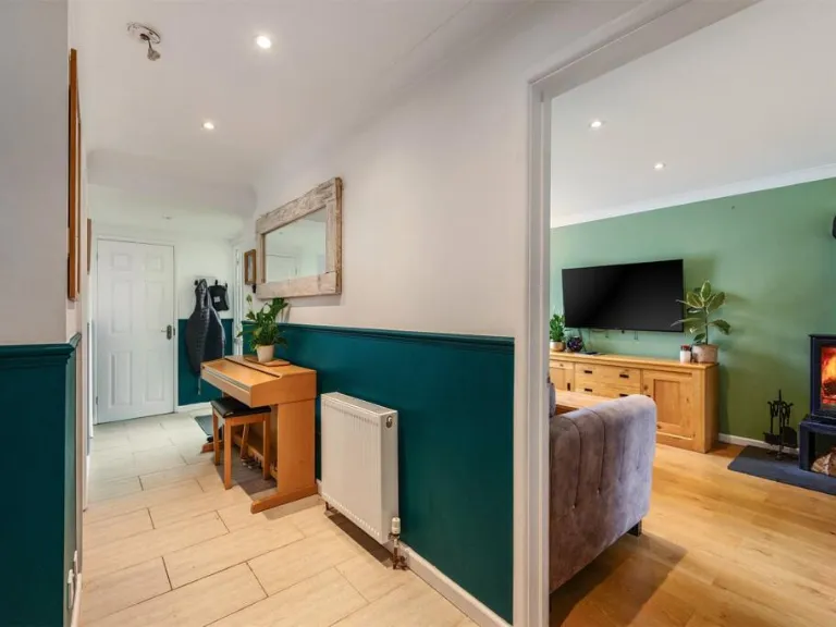
- living room modern
Rooms
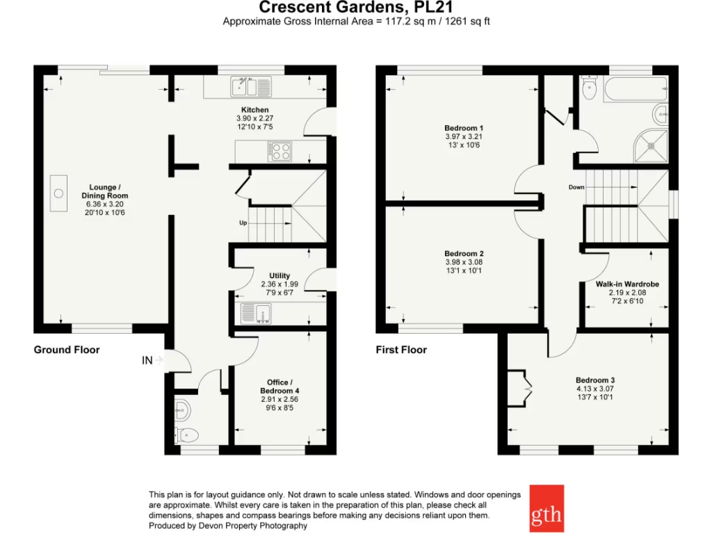
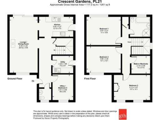
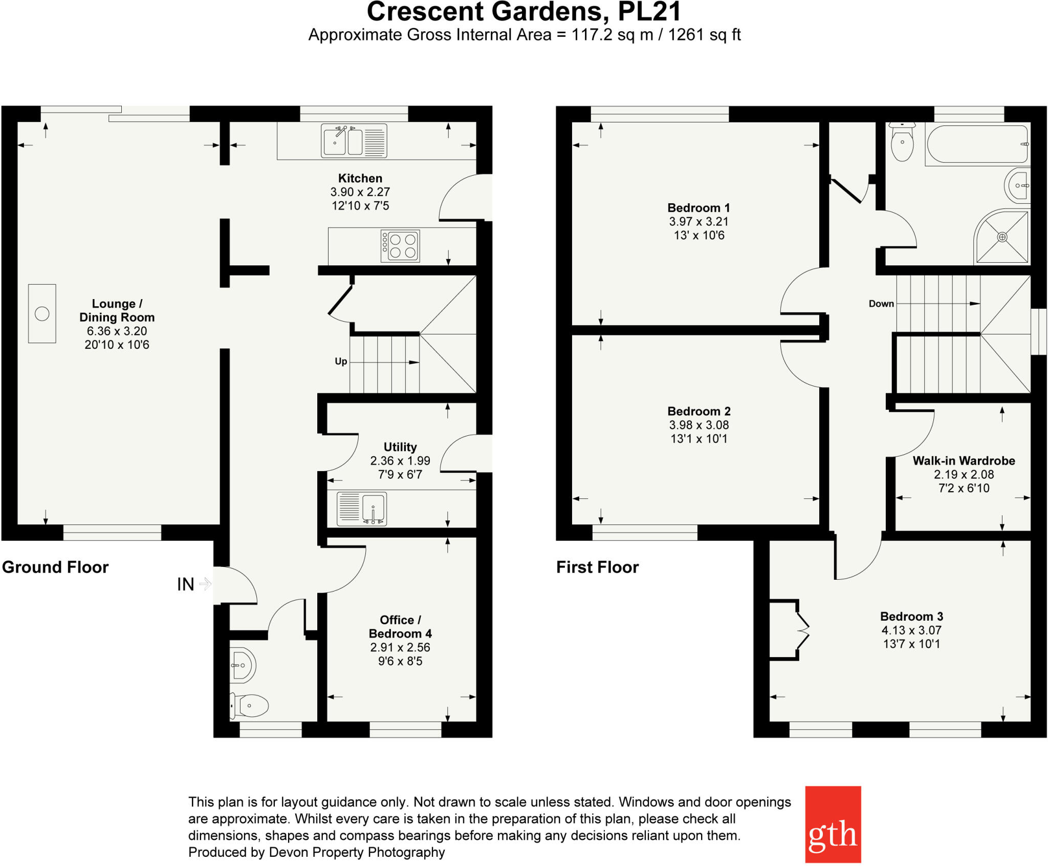
- Lounge / Dining Room:
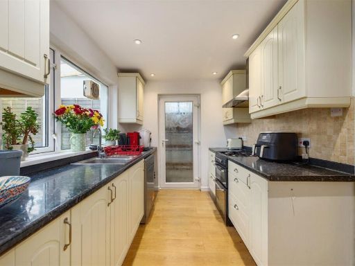
- Kitchen:
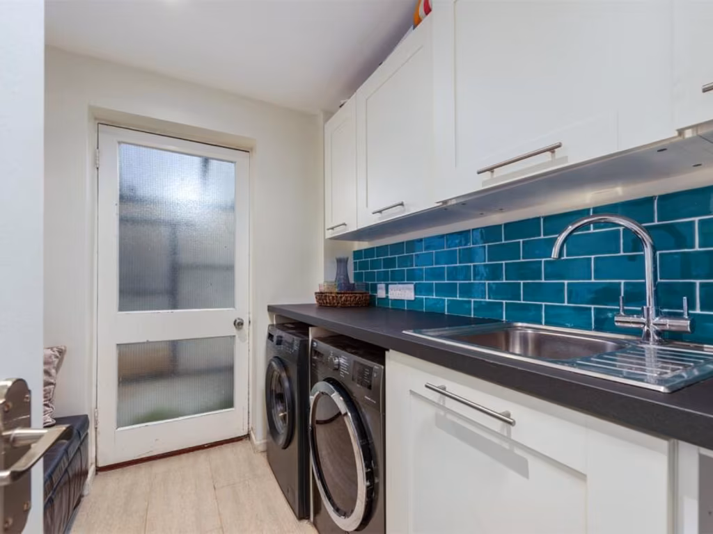
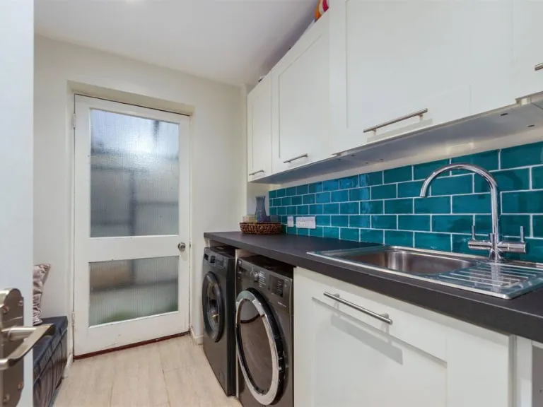
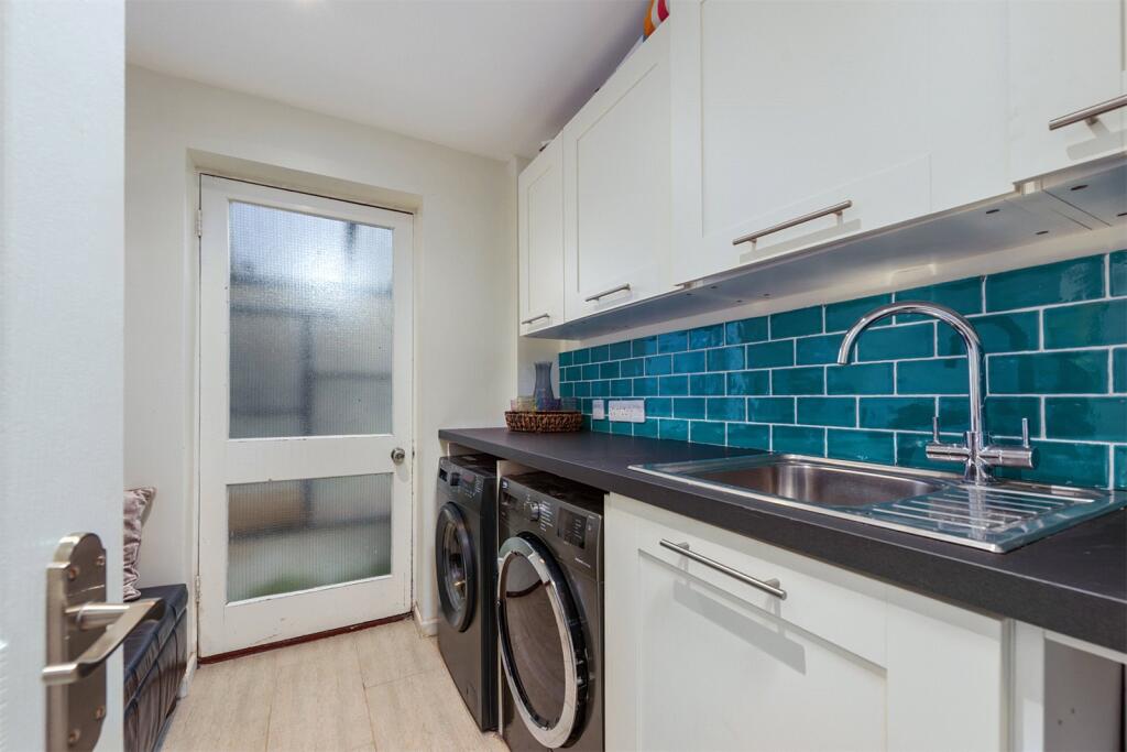
- Utility:
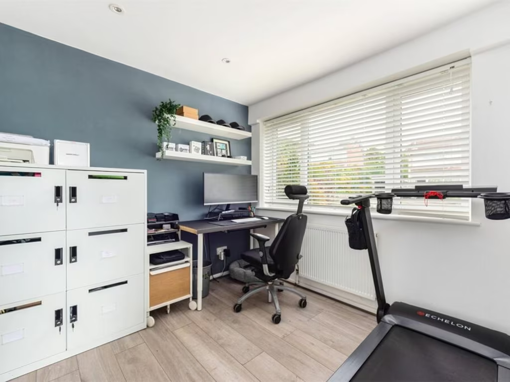
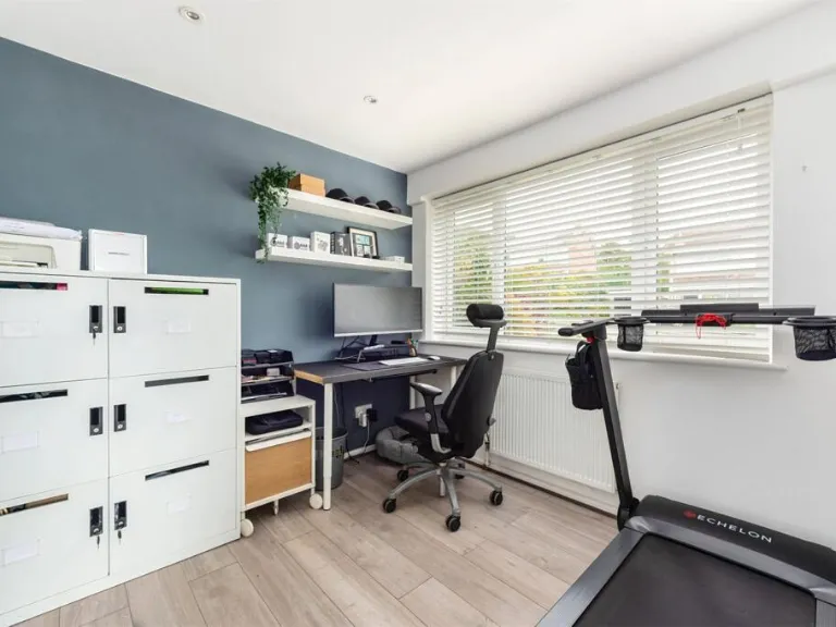
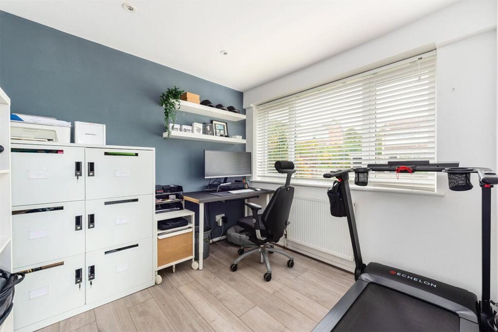
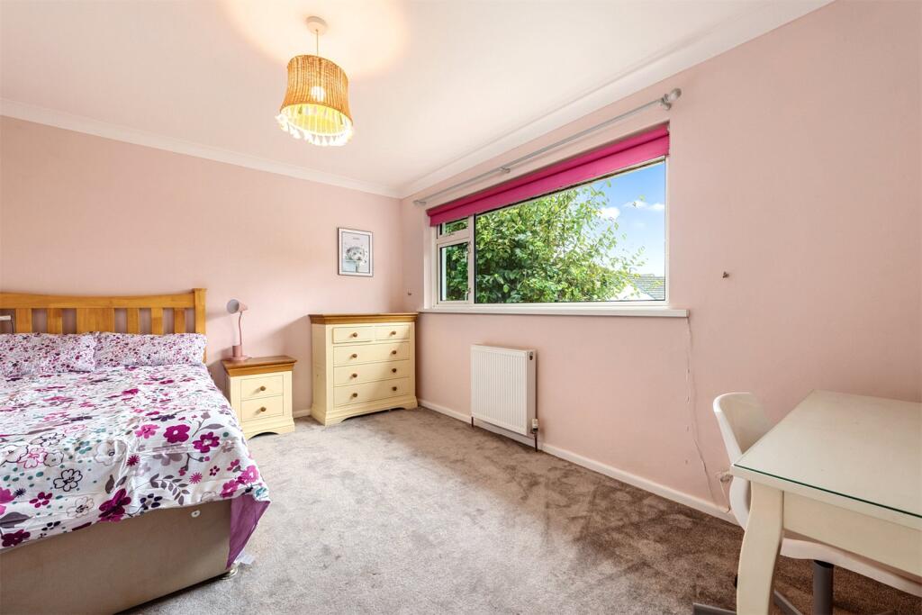
- Office / Bedroom 4:
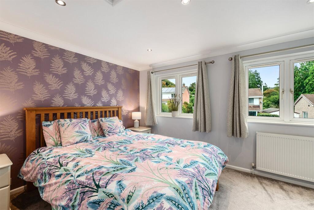
- Bedroom 1:
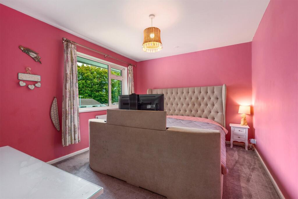
- Bedroom 2:
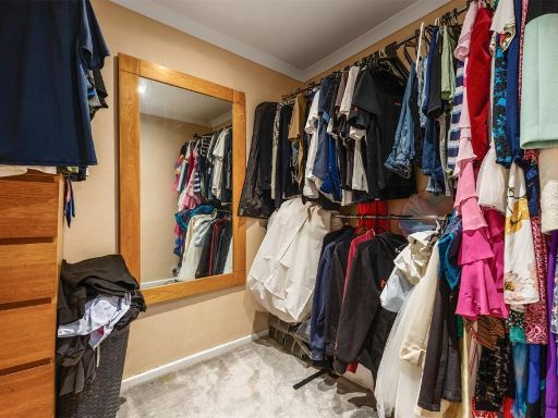
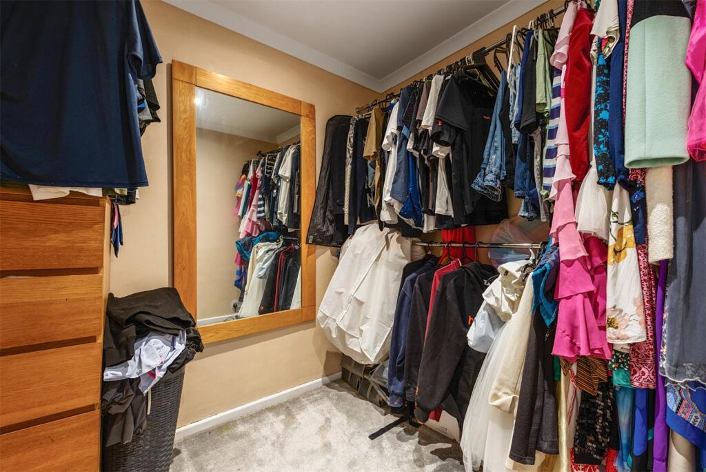
- Walk-in Wardrobe:
- Bedroom 3:
Textual Property Features
Detected Visual Features
- modern
- two-story
- detached
- brick
- stucco
- lawn
- residential
- suburban
- living room
- medium size
- standard ceiling
- green wall
- wood flooring
- large window
- natural light
EPC Details
- Fully double glazed
- Cavity wall, filled cavity
- Boiler and radiators, mains gas
- Low energy lighting in 60% of fixed outlets
- Solid, no insulation (assumed)
Nearby Schools
- Ermington Primary School
- Ugborough Primary School
- Woodlands Park Primary School
- The Erme Primary School
- Ivybridge Community College
- Sparkwell All Saints Primary School
- Glen Park Primary School
- Stowford School
- South Brent Primary School
- Yealmpton Primary School
- Holbeton Primary School
- Modbury Primary School
- Manor Primary School, Ivybridge
- Cornwood Church of England Primary School
- Yealmpstone Farm Primary School
- Chaddlewood Primary School
Nearest Bars And Restaurants
- Id: 3769218685
- Tags:
- Amenity: fast_food
- Cuisine: indian
- Name: Meghna Tandoori Take-Away
- TagsNormalized:
- fast food
- food
- indian
- tandoori
- Lat: 50.389611
- Lon: -3.9203786
- FullGeoHash: gbvnwv1kb83c
- PartitionGeoHash: gbvn
- Images:
- FoodStandards: null
- Distance: 426.9
,- Id: 2880578857
- Tags:
- Addr:
- City: Ivybridge
- Housenumber: 1
- Postcode: PL21 0AS
- Street: Harford Road
- Amenity: pub
- Name: The Bridge Inn
- Opening_hours: Mo 14:00-23:00; Th-Su 09:30-12:00
- Operator: Admiral Taverns
- Phone: +44 1752 923973
- Smoking: outside
- TagsNormalized:
- Lat: 50.3905684
- Lon: -3.9187598
- FullGeoHash: gbvnwv66q6bc
- PartitionGeoHash: gbvn
- Images:
- FoodStandards: null
- Distance: 426.1
,- Id: 3769218681
- Tags:
- Amenity: fast_food
- Cuisine: chinese
- Name: Joy King
- Source: survey
- TagsNormalized:
- Lat: 50.3896738
- Lon: -3.9203492
- FullGeoHash: gbvnwv1m1hpb
- PartitionGeoHash: gbvn
- Images:
- FoodStandards: null
- Distance: 422.1
,- Id: 373455415
- Tags:
- Amenity: pub
- Building: yes
- Level: 2
- Name: The Exchange
- Source: survey
- Source:geometry: Bing
- Wikidata: Q79837713
- TagsNormalized:
- Lat: 50.3898189
- Lon: -3.9203252
- FullGeoHash: gbvnwv1mcz1d
- PartitionGeoHash: gbvn
- Images:
- FoodStandards: null
- Distance: 409.6
,- Id: 3769218673
- Tags:
- Amenity: cafe
- Name: Friary Mill
- Source: survey
- TagsNormalized:
- Lat: 50.3898016
- Lon: -3.9205036
- FullGeoHash: gbvnwv1jveud
- PartitionGeoHash: gbvn
- Images:
- FoodStandards: null
- Distance: 404.3
}
Nearest General Shops
- Id: 3769218670
- Tags:
- Name: Creations Hair
- Phone: +44 1752 893606
- Shop: hairdresser
- Source: survey
- TagsNormalized:
- Lat: 50.3895965
- Lon: -3.9207404
- FullGeoHash: gbvnwv1h8js5
- PartitionGeoHash: gbvn
- Images:
- FoodStandards: null
- Distance: 415.3
,- Id: 3769218697
- Tags:
- Name: True Designs
- Shop: clothes
- Source: survey
- TagsNormalized:
- Lat: 50.3896193
- Lon: -3.9206927
- FullGeoHash: gbvnwv1hc1ze
- PartitionGeoHash: gbvn
- Images:
- FoodStandards: null
- Distance: 414.7
,- Id: 3769218692
- Tags:
- Name: St Luke’s Hospice
- Shop: charity
- TagsNormalized:
- Lat: 50.3898424
- Lon: -3.9204738
- FullGeoHash: gbvnwv1nn76y
- PartitionGeoHash: gbvn
- Images:
- FoodStandards: null
- Distance: 401.6
}
Nearest Grocery shops
- Id: 329910649
- Tags:
- Addr:
- City: Ivybridge
- Housenumber: 14
- Postcode: PL21 9PS
- Street: Glanvilles Mill
- Atm: yes
- Branch: ivybridge - Glanvilles Mill
- Brand: The Co-operative Food
- Brand:wikidata: Q107617274
- Building: yes
- Name: The Co-operative Food
- Opening_hours: Mo-Sa 06:00-22:00; Su 10:00-16:00
- Shop: supermarket
- TagsNormalized:
- atm
- the co-operative food
- food
- shop
- Lat: 50.3890712
- Lon: -3.9204797
- FullGeoHash: gbvnwv11w5wm
- PartitionGeoHash: gbvn
- Images:
- FoodStandards: null
- Distance: 475.5
,- Id: 329908872
- Tags:
- Addr:
- City: Ivybridge
- Postcode: PL21 0SZ
- Street: Leonards Road
- Atm: yes
- Branch: Ivybridge Express
- Brand: Tesco Express
- Brand:wikidata: Q98456772
- Building: retail
- Contact:
- Website: https://www.tesco.com/store-locator/ivybrige/leonards-rd
- Name: Tesco Express
- Opening_hours: Mo-Su 06:00-23:00
- Shop: convenience
- TagsNormalized:
- atm
- tesco
- tesco express
- retail
- convenience
- shop
- Lat: 50.3899214
- Lon: -3.9191113
- FullGeoHash: gbvnwv4nw44v
- PartitionGeoHash: gbvn
- Images:
- FoodStandards: null
- Distance: 455.2
,- Id: 329910650
- Tags:
- Addr:
- City: Ivybridge
- Housename: Warrenstone
- Postcode: PL21 0BD
- Street: Costly Street
- Brand: Morrisons Daily
- Brand:wikidata: Q99752411
- Brand:wikipedia: en:McColl's
- Building: yes
- Contact:
- Website: https://my.morrisons.com/storefinder/35965
- Name: Morrisons Daily
- Shop: convenience
- TagsNormalized:
- morrisons
- morrisons daily
- convenience
- shop
- Lat: 50.3901606
- Lon: -3.9191498
- FullGeoHash: gbvnwv4pvny0
- PartitionGeoHash: gbvn
- Images:
- FoodStandards: null
- Distance: 434.4
}
Nearest Supermarkets
- Id: 875749763
- Tags:
- Brand: ALDI
- Brand:wikidata: Q41171672
- Brand:wikipedia: en:Aldi
- Building: retail
- Contact:
- Website: https://stores.aldi.co.uk/plympton/galileo-close
- Name: Aldi
- Opening_hours: Mo-Sa 08:00-22:00; Su 10:00-16:00
- Shop: supermarket
- TagsNormalized:
- aldi
- retail
- supermarket
- shop
- Lat: 50.3929982
- Lon: -4.0483748
- FullGeoHash: gbvnevu06p8z
- PartitionGeoHash: gbvn
- Images:
- FoodStandards: null
- Distance: 8847.3
,- Id: 1881279276
- Tags:
- Addr:
- Housenumber: 2-4
- Postcode: TQ10 9AB
- Street: Church Street
- Name: Co-op
- Shop: supermarket
- TagsNormalized:
- Lat: 50.426438
- Lon: -3.8349226
- FullGeoHash: gbvqbez7rc67
- PartitionGeoHash: gbvq
- Images:
- FoodStandards: null
- Distance: 7307.3
,- Id: 42135017
- Tags:
- Addr:
- City: Ivybridge
- Housename: Lee Mill Industrial Estate
- Postcode: PL21 9PE
- Street: Central Avenue
- Branch: Ivybridge Lee Mill Extra
- Brand: Tesco Extra
- Brand:wikidata: Q25172225
- Building: yes
- Contact:
- Website: https://www.tesco.com/store-locator/ivybridge/central-avenue
- Name: Tesco Extra
- Operator: Tesco Stores Ltd.
- Phone: +44 345 677 9816
- Shop: supermarket
- Wheelchair: yes
- TagsNormalized:
- tesco
- tesco extra
- supermarket
- shop
- Lat: 50.3859588
- Lon: -3.9652459
- FullGeoHash: gbvntu2x7p6r
- PartitionGeoHash: gbvn
- Images:
- FoodStandards: null
- Distance: 3052.8
}
Nearest Religious buildings
- Id: 555459110
- Tags:
- Addr:
- City: Ivybridge
- Street: Fore Street
- Amenity: place_of_worship
- Building: church
- Denomination: methodist
- Description: Area includes hall and other building
- Name: Ivybridge Methodist Church
- Religion: christian
- Service_times: 10:30
- TagsNormalized:
- place of worship
- church
- methodist
- christian
- Lat: 50.388181
- Lon: -3.9231533
- FullGeoHash: gbvnwszhrvsz
- PartitionGeoHash: gbvn
- Images:
- FoodStandards: null
- Distance: 521.9
,- Id: 918399254
- Tags:
- Amenity: place_of_worship
- Name: Ivybridge Baptist Church
- Religion: christian
- Source: OS_OpenData_Streetview
- TagsNormalized:
- place of worship
- baptist
- church
- christian
- Lat: 50.3903109
- Lon: -3.9184808
- FullGeoHash: gbvnwv68ufbb
- PartitionGeoHash: gbvn
- Images:
- FoodStandards: null
- Distance: 459.3
,- Id: 663812566
- Tags:
- Amenity: place_of_worship
- Building: church
- Denomination: anglican
- Name: St John the Evangelist
- Religion: christian
- Source: OS_OpenData_Streetview
- Wikidata: Q105086686
- TagsNormalized:
- place of worship
- church
- anglican
- evangelist
- christian
- Lat: 50.3914592
- Lon: -3.9218494
- FullGeoHash: gbvnwv2pw2c4
- PartitionGeoHash: gbvn
- Images:
- FoodStandards: null
- Distance: 198.4
}
Nearest Medical buildings
- Id: 3769218700
- Tags:
- Amenity: pharmacy
- Name: day lewis Pharmacy
- Source: survey
- TagsNormalized:
- pharmacy
- day lewis pharmacy
- Lat: 50.389188
- Lon: -3.9212235
- FullGeoHash: gbvnwv0dkc7y
- PartitionGeoHash: gbvn
- Images:
- FoodStandards: null
- Distance: 441.6
,- Id: 3769218687
- Tags:
- Addr:
- Amenity: dentist
- Brand: Bupa
- Brand:wikidata: Q931628
- Brand:wikipedia: en:Bupa
- Contact:
- Website: https://www.bupa.co.uk/dental/dental-care/practices/ivybridge
- Healthcare: dentist
- Name: Bupa Dental Care
- TagsNormalized:
- dentist
- bupa
- health
- healthcare
- dental
- Lat: 50.3897009
- Lon: -3.9206302
- FullGeoHash: gbvnwv1j69n4
- PartitionGeoHash: gbvn
- Images:
- FoodStandards: null
- Distance: 409.1
,- Id: 306365573
- Tags:
- TagsNormalized:
- Lat: 50.3917634
- Lon: -3.9207408
- FullGeoHash: gbvnwv9121ec
- PartitionGeoHash: gbvn
- Images:
- FoodStandards: null
- Distance: 235.1
,- Id: 727602726
- Tags:
- Amenity: clinic
- Building: yes
- Healthcare: clinic
- Name: Ivybridge Medical Centre
- TagsNormalized:
- Lat: 50.391823
- Lon: -3.9207546
- FullGeoHash: gbvnwv8cxu9m
- PartitionGeoHash: gbvn
- Images:
- FoodStandards: null
- Distance: 230.9
}
Nearest Leisure Facilities
- Id: 1035965645
- Tags:
- Access: private
- Leisure: swimming_pool
- Location: outdoor
- TagsNormalized:
- swimming
- swimming pool
- pool
- leisure
- Lat: 50.3892252
- Lon: -3.9251682
- FullGeoHash: gbvnwtjf8bqk
- PartitionGeoHash: gbvn
- Images:
- FoodStandards: null
- Distance: 420.5
,- Id: 3769375814
- Tags:
- Leisure: club
- Name: Constitutional Club
- Source: survey
- TagsNormalized:
- Lat: 50.3913448
- Lon: -3.9203836
- FullGeoHash: gbvnwv3qb7w0
- PartitionGeoHash: gbvn
- Images:
- FoodStandards: null
- Distance: 282.2
,- Id: 850847583
- Tags:
- Leisure: park
- Operator: south hams council
- TagsNormalized:
- Lat: 50.3909187
- Lon: -3.9248845
- FullGeoHash: gbvnwtmurs1f
- PartitionGeoHash: gbvn
- Images:
- FoodStandards: null
- Distance: 235.8
,- Id: 850854361
- Tags:
- Leisure: pitch
- Sport: basketball
- Surface: asphalt
- TagsNormalized:
- pitch
- leisure
- basketball
- sports
- Lat: 50.3921881
- Lon: -3.921402
- FullGeoHash: gbvnwv8eb8ww
- PartitionGeoHash: gbvn
- Images:
- FoodStandards: null
- Distance: 171.2
,- Id: 1094738166
- Tags:
- Access: private
- Leisure: swimming_pool
- Location: outdoor
- TagsNormalized:
- swimming
- swimming pool
- pool
- leisure
- Lat: 50.3918025
- Lon: -3.9244851
- FullGeoHash: gbvnwtw38bgf
- PartitionGeoHash: gbvn
- Images:
- FoodStandards: null
- Distance: 135
}
Nearest Tourist attractions
- Id: 6680273018
- Tags:
- Name: Harford Bunkhouse
- Phone: +44 7968 566 218
- Tourism: hostel
- Website: https://www.harfordbunkhouse.co.uk
- TagsNormalized:
- Lat: 50.4092
- Lon: -3.91356
- FullGeoHash: gbvnybwnz7yn
- PartitionGeoHash: gbvn
- Images:
- FoodStandards: null
- Distance: 1949.8
,- Id: 3085170361
- Tags:
- Name: The Donkey Sanctuary
- Tourism: attraction
- TagsNormalized:
- Lat: 50.3810907
- Lon: -3.9102053
- FullGeoHash: gbvnx58ejs58
- PartitionGeoHash: gbvn
- Images:
- FoodStandards: null
- Distance: 1616.3
,- Id: 257755151
- Tags:
- Attraction: gardens
- Name: Lukesland Gardens
- Tourism: attraction
- TagsNormalized:
- Lat: 50.4056912
- Lon: -3.9141236
- FullGeoHash: gbvnybjf6mcu
- PartitionGeoHash: gbvn
- Images:
- FoodStandards: null
- Distance: 1575.4
}
Nearest Train stations
- Id: 7821383480
- Tags:
- Name: Kingsbridge Park Side
- Operator: Kingsbridge and District Light Railway
- Public_transport: station
- Railway: station
- Train: yes
- Usage: tourism
- TagsNormalized:
- Lat: 50.2804378
- Lon: -3.7745489
- FullGeoHash: gbvq4172y8uq
- PartitionGeoHash: gbvq
- Images:
- FoodStandards: null
- Distance: 16375.3
,- Id: 7821403685
- Tags:
- Name: Kingsbridge Ria End
- Operator: Kingsbridge and District Light Railway
- Public_transport: station
- Railway: station
- Train: yes
- Usage: tourism
- TagsNormalized:
- Lat: 50.2822448
- Lon: -3.7755403
- FullGeoHash: gbvq41der9c1
- PartitionGeoHash: gbvq
- Images:
- FoodStandards: null
- Distance: 16176.5
,- Id: 4098520591
- Tags:
- Name: Plymouth
- Naptan:
- Network: National Rail
- Public_transport: station
- Railway: station
- Ref:
- Wheelchair: yes
- Wikidata: Q956813
- Wikipedia: en:Plymouth railway station
- TagsNormalized:
- Lat: 50.3780005
- Lon: -4.1433202
- FullGeoHash: gbvn9encjeuw
- PartitionGeoHash: gbvn
- Images:
- FoodStandards: null
- Distance: 15667.8
,- Id: 2089237068
- Tags:
- Name: Plym Bridge
- Old_name: Plym Bridge (Halt)
- Public_transport: station
- Railway: station
- Start_date: 30 December 2012
- Usage: tourism
- Wikipedia: en:Plym Valley Railway
- TagsNormalized:
- Lat: 50.4087718
- Lon: -4.079354
- FullGeoHash: gbvng0ts2hjh
- PartitionGeoHash: gbvn
- Images:
- FoodStandards: null
- Distance: 11182.3
,- Id: 29264839
- Tags:
- Name: Ivybridge
- Naptan:
- Network: National Rail
- Public_transport: station
- Railway: station
- Ref:
- Wheelchair: yes
- Wikipedia: en:Ivybridge railway station
- TagsNormalized:
- Lat: 50.393467
- Lon: -3.9050319
- FullGeoHash: gbvnxju7npj5
- PartitionGeoHash: gbvn
- Images:
- FoodStandards: null
- Distance: 1315.8
}
Nearest Bus stations and stops
- Id: 9623866158
- Tags:
- Bus: yes
- Highway: bus_stop
- Public_transport: platform
- TagsNormalized:
- Lat: 50.3930724
- Lon: -3.904077
- FullGeoHash: gbvnxjv0umt1
- PartitionGeoHash: gbvn
- Images:
- FoodStandards: null
- Distance: 1382
,- Id: 10064502750
- Tags:
- Bus: yes
- Highway: bus_stop
- Public_transport: platform
- TagsNormalized:
- Lat: 50.3904264
- Lon: -3.9074049
- FullGeoHash: gbvnxj69wb79
- PartitionGeoHash: gbvn
- Images:
- FoodStandards: null
- Distance: 1177.6
,- Id: 10064502733
- Tags:
- Bus: yes
- Highway: bus_stop
- Public_transport: platform
- TagsNormalized:
- Lat: 50.3923844
- Lon: -3.9070657
- FullGeoHash: gbvnxjduyv29
- PartitionGeoHash: gbvn
- Images:
- FoodStandards: null
- Distance: 1171.2
,- Id: 10059469933
- Tags:
- Bus: yes
- Highway: bus_stop
- Public_transport: platform
- TagsNormalized:
- Lat: 50.3936537
- Lon: -3.9087665
- FullGeoHash: gbvnxjcsr1um
- PartitionGeoHash: gbvn
- Images:
- FoodStandards: null
- Distance: 1053
,- Id: 558421271
- Tags:
- Bus: yes
- Highway: bus_stop
- Public_transport: platform
- TagsNormalized:
- Lat: 50.3948961
- Lon: -3.9133887
- FullGeoHash: gbvnwyn7e3tb
- PartitionGeoHash: gbvn
- Images:
- FoodStandards: null
- Distance: 756.2
}
Nearest Hotels
- Id: 318097682
- Tags:
- Building: yes
- Name: Kitley House Hotel
- Tourism: hotel
- Website: https://www.kitleyhousehotel.com/
- Wikidata: Q17527169
- TagsNormalized:
- Lat: 50.3453989
- Lon: -4.0257594
- FullGeoHash: gbvnkmhe1n84
- PartitionGeoHash: gbvn
- Images:
- FoodStandards: null
- Distance: 8966
,- Id: 734724677
- Tags:
- Building: yes
- Name: White Hart
- Tourism: hotel
- TagsNormalized:
- Lat: 50.3490264
- Lon: -3.887198
- FullGeoHash: gbvnrtc2mdz1
- PartitionGeoHash: gbvn
- Images:
- FoodStandards: null
- Distance: 5515.3
,- Id: 691527567
- Tags:
- Building: yes
- Name: Welbeck Manor
- Tourism: hotel
- TagsNormalized:
- Lat: 50.4055749
- Lon: -3.994766
- FullGeoHash: gbvnv051g0nw
- PartitionGeoHash: gbvn
- Images:
- FoodStandards: null
- Distance: 5240.4
}
Tags
- modern
- two-story
- detached
- brick
- stucco
- lawn
- residential
- suburban
- modern
- living room
- medium size
- standard ceiling
- green wall
- wood flooring
- large window
- natural light
Local Market Stats
- Average Price/sqft: £308
- Avg Income: £48200
- Rental Yield: 4%
- Social Housing: 3%
- Planning Success Rate: 86%
AirBnB Data
- 1km average: £90/night
- Listings in 1km: 2
Similar Properties
 4 bedroom detached house for sale in Crescent Gardens, Ivybridge, Devon, PL21 — £435,000 • 4 bed • 2 bath • 1058 ft²
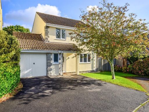 3 bedroom detached house for sale in The Spinney, Woodlands, Ivybridge, Devon, PL21 — £395,000 • 3 bed • 2 bath • 984 ft²
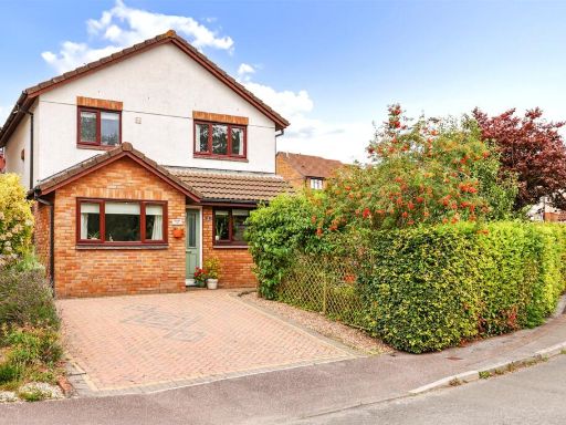 4 bedroom detached house for sale in Claymans Pathway, Woodlands, Ivybridge, Devon, PL21 — £390,000 • 4 bed • 2 bath • 1114 ft²
 6 bedroom detached house for sale in Tom Maddock Gardens, Ivybridge, Devon, PL21 — £830,000 • 6 bed • 4 bath • 3289 ft²
 4 bedroom detached bungalow for sale in Crescent Gardens, Ivybridge, PL21 0BS, PL21 — £550,000 • 4 bed • 2 bath • 1536 ft²
 3 bedroom semi-detached house for sale in Julian Road, Ivybridge, Devon, PL21 — £315,000 • 3 bed • 1 bath • 945 ft²
Meta
- {
"@context": "https://schema.org",
"@type": "Residence",
"name": "4 bedroom detached house for sale in Crescent Gardens, Ivyb…",
"description": "",
"url": "https://propertypiper.co.uk/property/5df705f6-be44-4727-8e49-63cd9f2a80f5",
"image": "https://image-a.propertypiper.co.uk/5355a92d-9544-4d4c-8e30-d9287afd78b7-1024.jpeg",
"address": {
"@type": "PostalAddress",
"streetAddress": "26 CRESCENT GARDENS IVYBRIDGE",
"postalCode": "PL21 0BS",
"addressLocality": "South Hams",
"addressRegion": "South West Devon",
"addressCountry": "England"
},
"geo": {
"@type": "GeoCoordinates",
"latitude": 50.39286681959139,
"longitude": -3.92356996359858
},
"numberOfRooms": 4,
"numberOfBathroomsTotal": 2,
"floorSize": {
"@type": "QuantitativeValue",
"value": 1261,
"unitCode": "FTK"
},
"offers": {
"@type": "Offer",
"price": 435000,
"priceCurrency": "GBP",
"availability": "https://schema.org/InStock"
},
"additionalProperty": [
{
"@type": "PropertyValue",
"name": "Feature",
"value": "modern"
},
{
"@type": "PropertyValue",
"name": "Feature",
"value": "two-story"
},
{
"@type": "PropertyValue",
"name": "Feature",
"value": "detached"
},
{
"@type": "PropertyValue",
"name": "Feature",
"value": "brick"
},
{
"@type": "PropertyValue",
"name": "Feature",
"value": "stucco"
},
{
"@type": "PropertyValue",
"name": "Feature",
"value": "lawn"
},
{
"@type": "PropertyValue",
"name": "Feature",
"value": "residential"
},
{
"@type": "PropertyValue",
"name": "Feature",
"value": "suburban"
},
{
"@type": "PropertyValue",
"name": "Feature",
"value": "modern"
},
{
"@type": "PropertyValue",
"name": "Feature",
"value": "living room"
},
{
"@type": "PropertyValue",
"name": "Feature",
"value": "medium size"
},
{
"@type": "PropertyValue",
"name": "Feature",
"value": "standard ceiling"
},
{
"@type": "PropertyValue",
"name": "Feature",
"value": "green wall"
},
{
"@type": "PropertyValue",
"name": "Feature",
"value": "wood flooring"
},
{
"@type": "PropertyValue",
"name": "Feature",
"value": "large window"
},
{
"@type": "PropertyValue",
"name": "Feature",
"value": "natural light"
}
]
}
High Res Floorplan Images
Compatible Floorplan Images
FloorplanImages Thumbnail