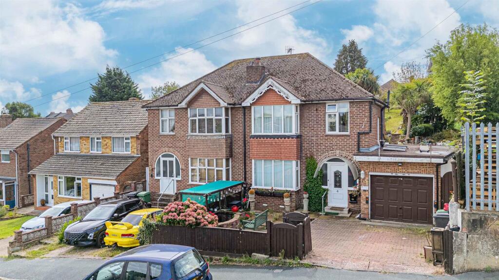
TN34 2ND - 3 bedroom semidetached house for sale in Normandy Road, Has…
View on Property Piper
3 bedroom semi-detached house for sale in Normandy Road, Hastings, TN34
Property Details
- Price: £325000
- Bedrooms: 3
- Bathrooms: 1
- Property Type: undefined
- Property SubType: undefined
Brochure Descriptions
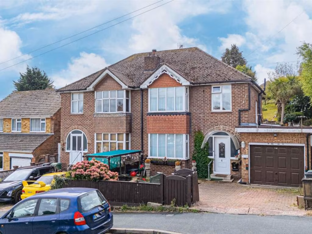
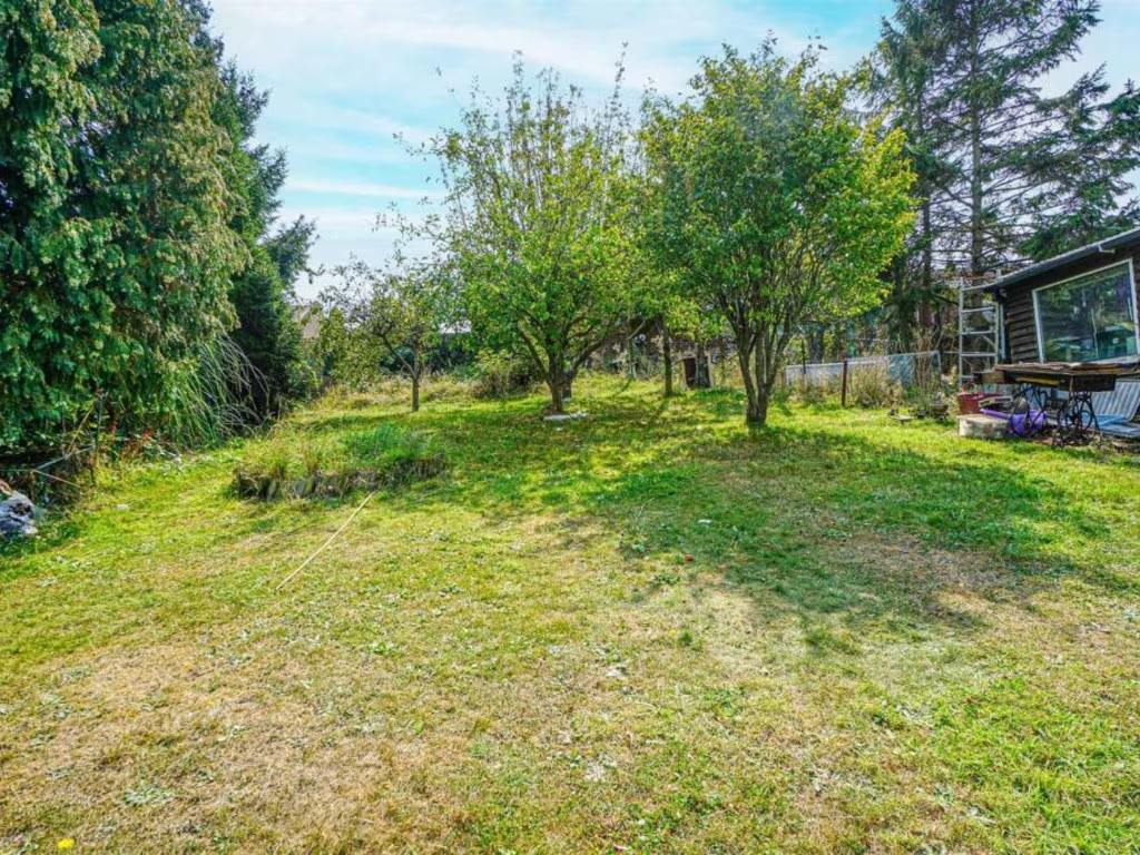
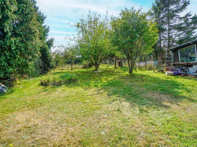
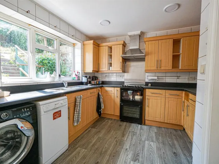
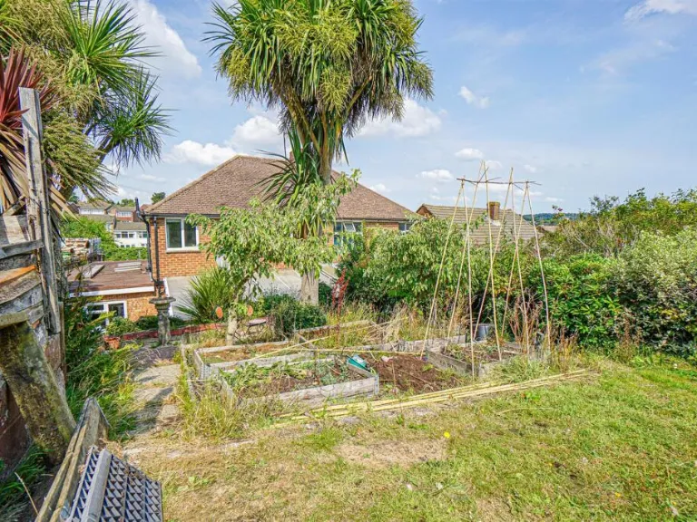
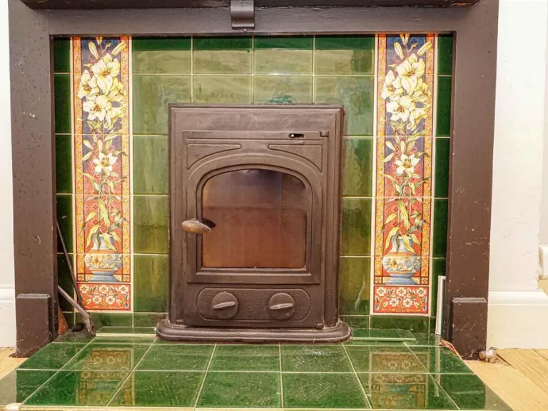
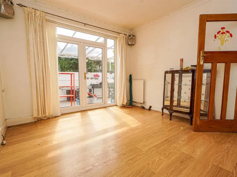
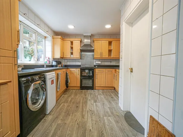
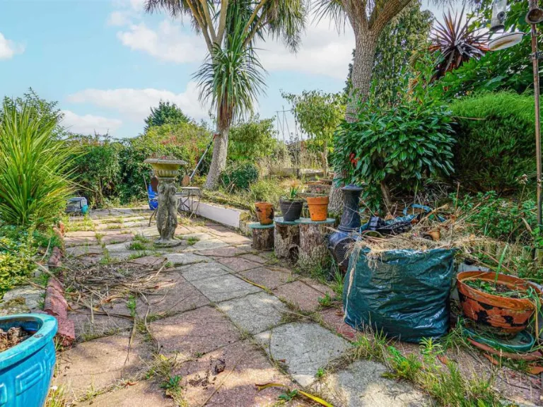
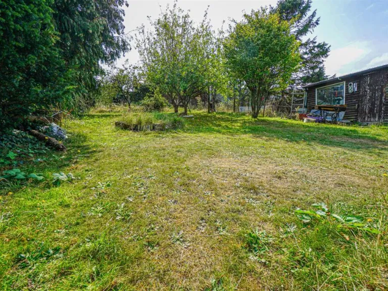
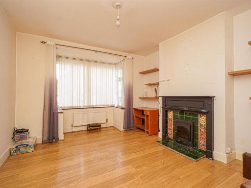
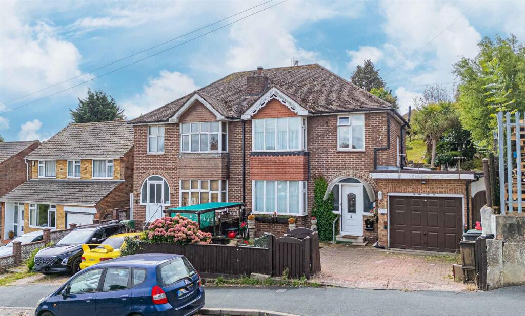
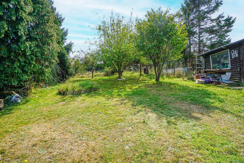
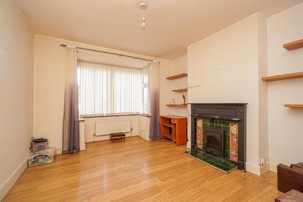
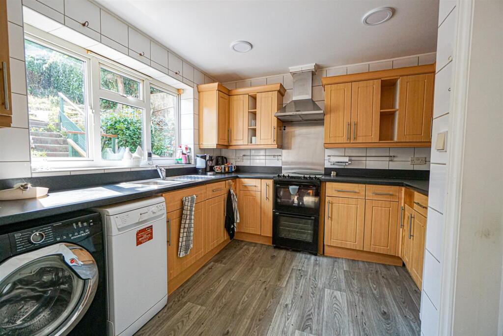
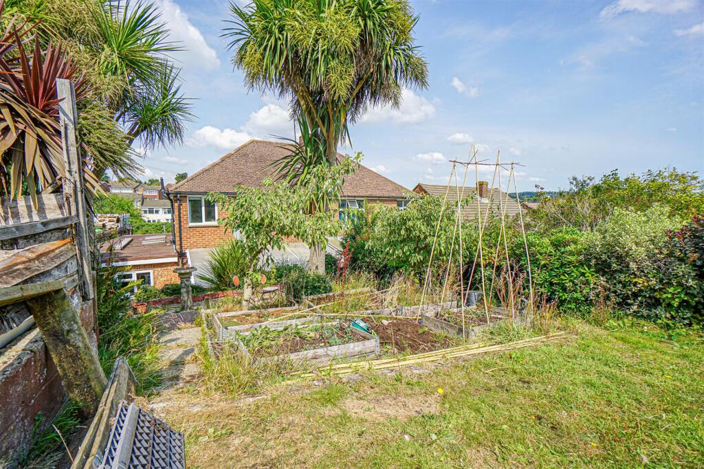
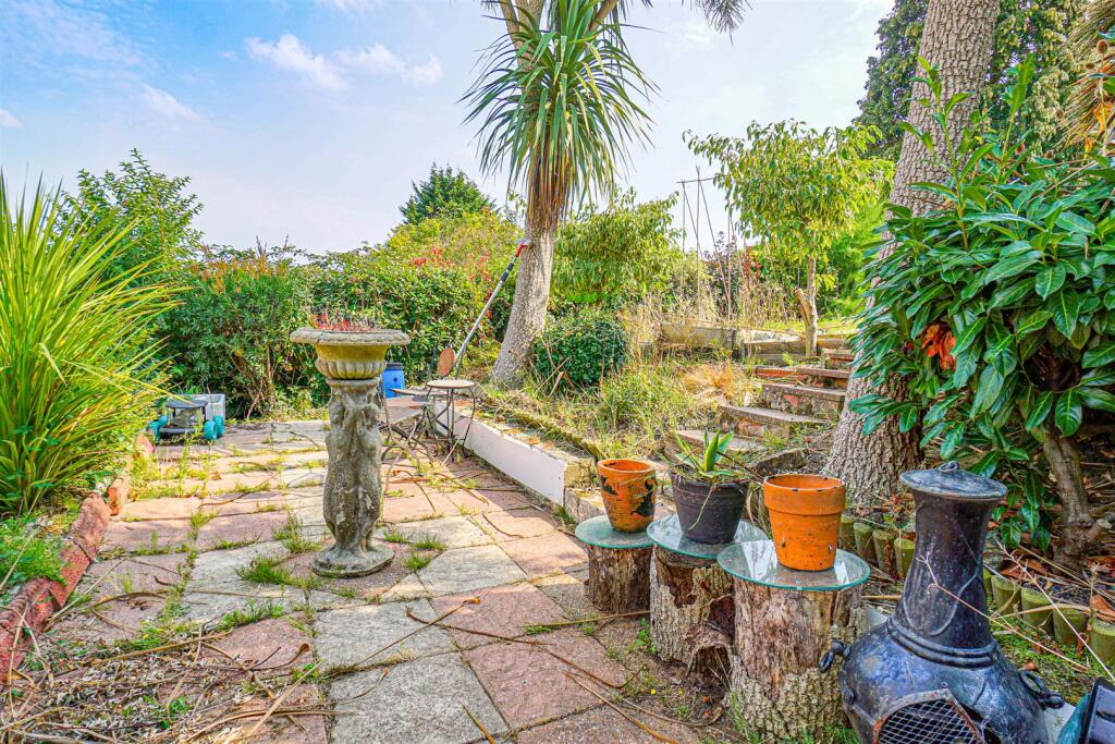
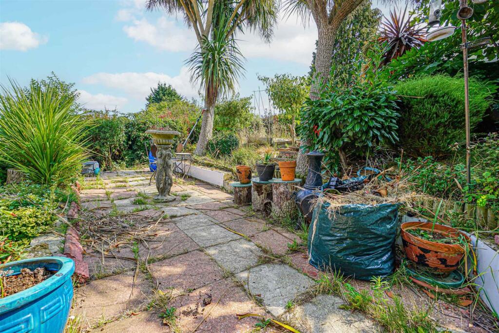
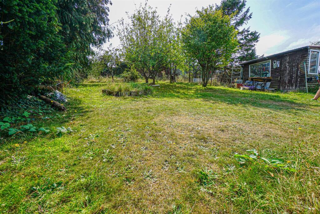
- The property is a brick-built semi-detached house, located in an established residential area. It features an integrated garage with private driveway and a compact, well-maintained front garden behind a wooden fence. The rear garden is sizeable, with mature trees and a lawn, suitable for families or gardening enthusiasts. Internally, rooms are bright and of average size, including a spacious reception with a fireplace, a good-sized kitchen with dual aspect windows, and ample cabinetry. Overall, the property appears to be of average size for the area, suitable for a small to medium family.
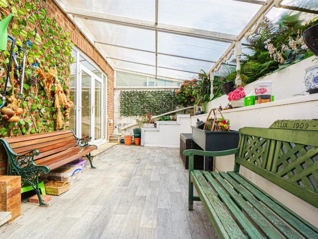
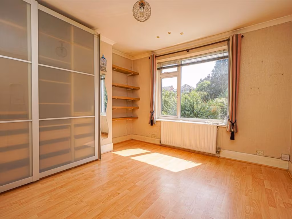
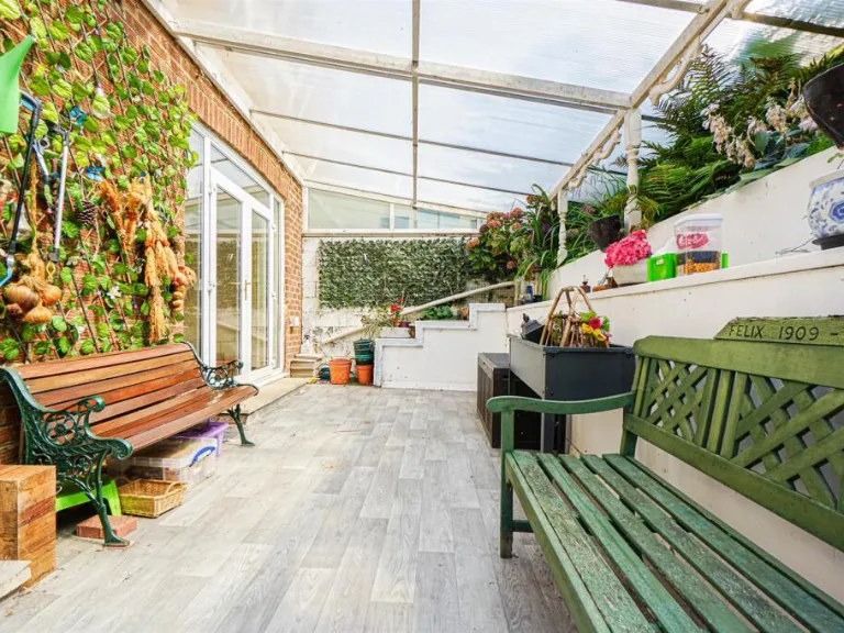
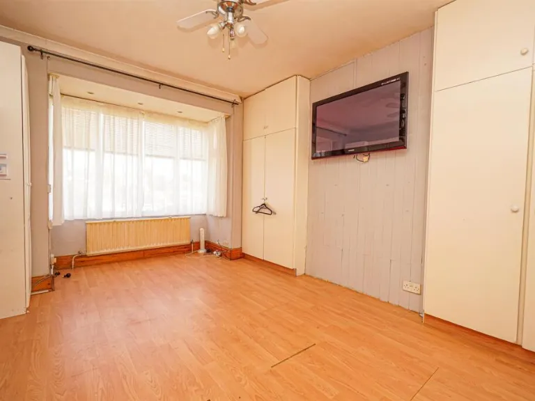
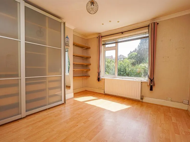
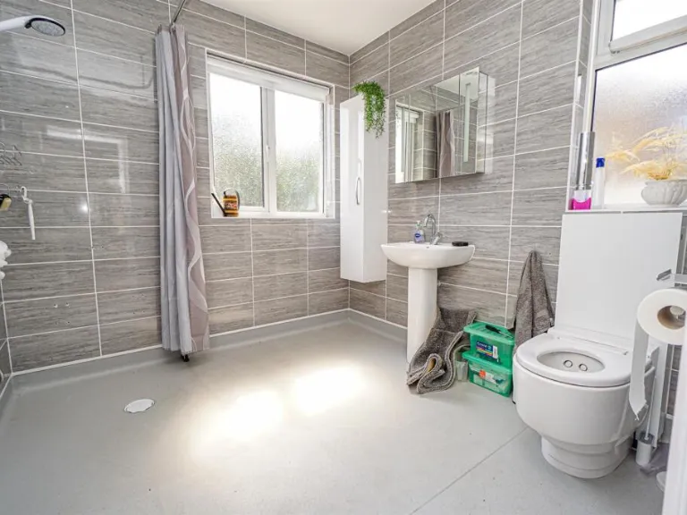
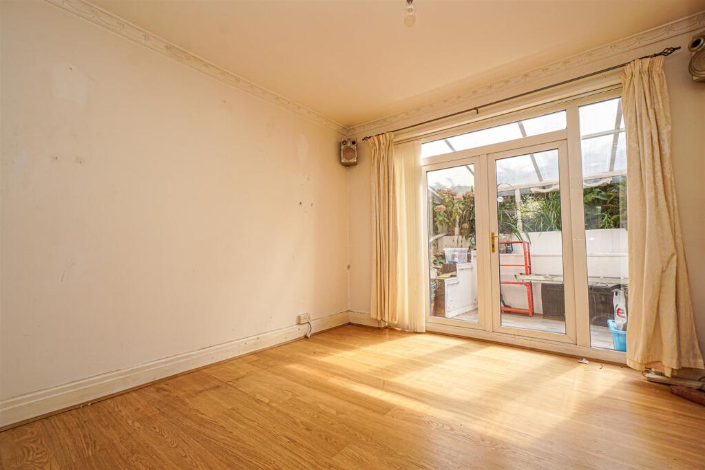
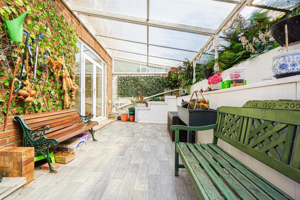
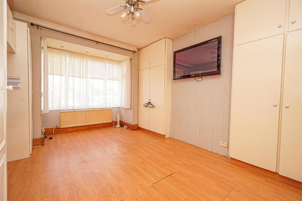
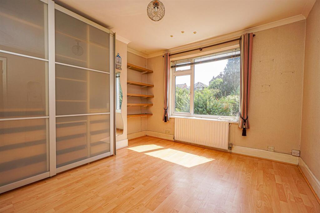
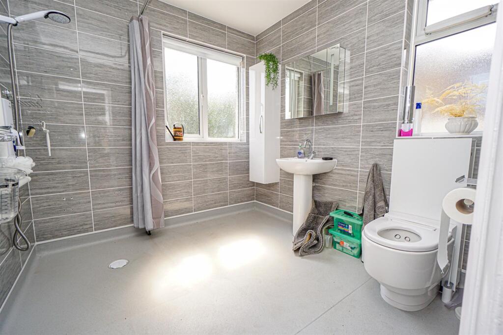
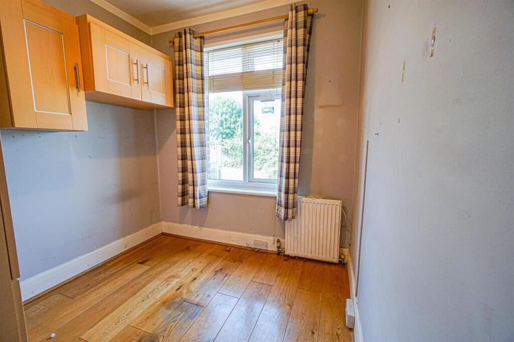
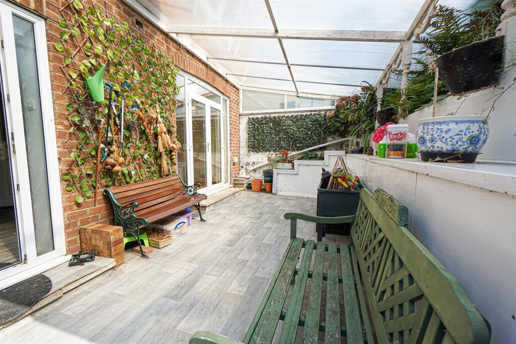
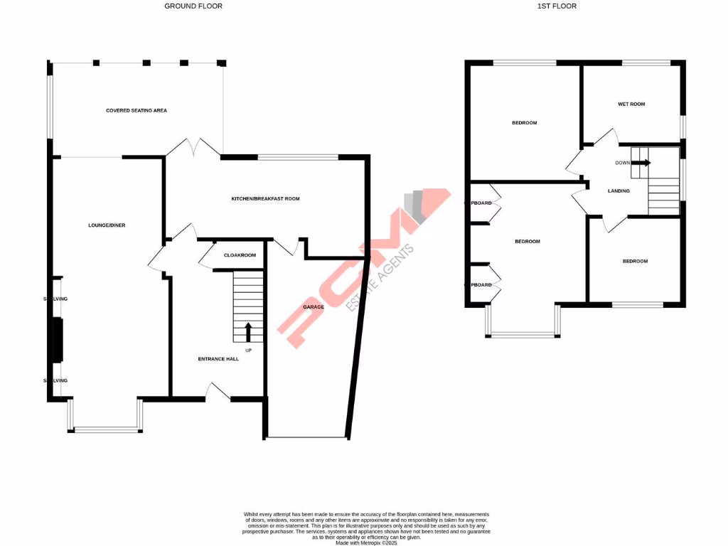
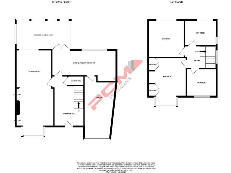
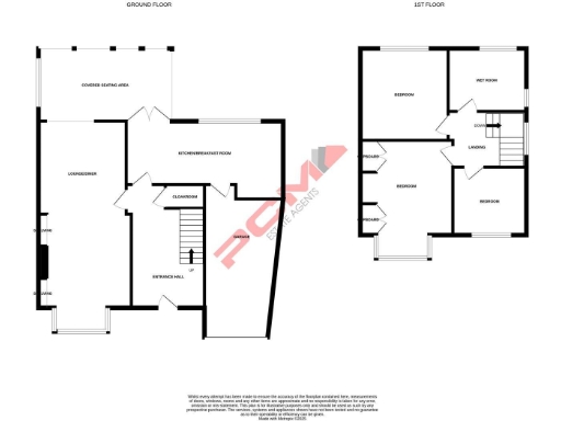
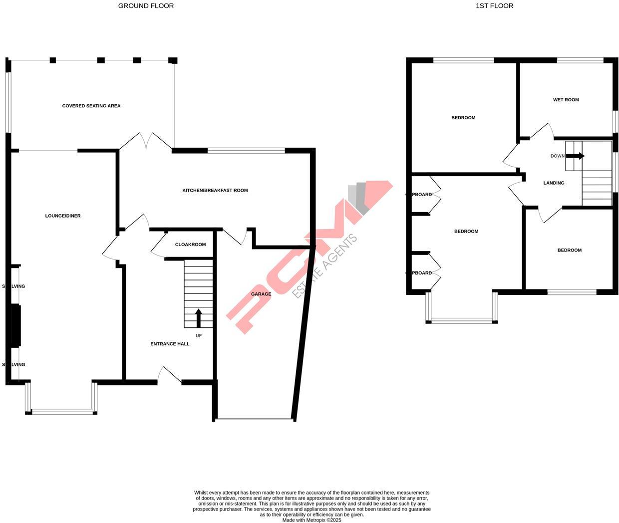
- This property is a two-storey detached house consisting of three bedrooms, a wet room, and a landing on the first floor. The ground floor includes a generous entrance hall, cloakroom, kitchen/breakfast room, lounge/diner, and a garage. There is also a substantial covered seating area at the rear, likely adjoining a large garden space. The reception areas and bedrooms appear to be of average to large size, indicating a solid family home with spacious living areas. The overall property size is generous and suggests comfortable accommodation for a family. No specific view is indicated from the images, and total square footage is not shown.
- This is an older style three-bedroom semi-detached house in a highly sought-after St Leonards location, offering excellent access to shopping facilities and Alexandra Park. The property features gas central heating, double glazing, and spacious accommodation including a 26ft lounge-diner and a 20ft kitchen-breakfast room. There is a downstairs WC, three bedrooms, and a wet room. Externally, the property provides private off-road parking and a garage, along with a large and well-tended rear garden featuring a covered seating area, lawn, established flowerbeds, trees, shrubs, greenhouse, shed, and side access. Rooms, especially the lounge-diner and kitchen, are large, and the overall property size is generous and suitable for a family.
Image Descriptions
- semi-detached house 1930s
- garden
Floorplan Description
- A two-story house with multiple bedrooms and a garage.
Rooms
- Living:
- Lounge/Diner:
- Kitchen/Breakfast Room:
- Cloakroom:
- Entrance Hall:
- Garage:
- Wet Room:
- Bedroom:
Textual Property Features
Detected Visual Features
- semi-detached
- 1930s
- period
- brick exterior
- garage
- garden
- three-bedroom
- suburban
- family home
- off-street parking
- gable roof
- overgrown
- landscaping
- tree
- grass
- fence
- unkempt
- natural
- outdoor space
EPC Details
- Mostly double glazing
- Cavity wall, filled cavity
- Boiler and radiators, mains gas
- Low energy lighting in all fixed outlets
- Suspended, no insulation (assumed)
Nearby Schools
- Pebsham Primary Academy
- St Leonards Church of England Primary Academy
- Christ Church CofE Primary and Nursery Academy
- St Paul's Church of England Academy
- The Baird Primary Academy
- Sandown Primary School and Nursery
- Westfield School
- The St Leonards Academy
- West St Leonards Primary Academy
- All Saints CofE Junior Academy
- Hollington Primary School
- Crowhurst CofE Primary School
- St Mary Star of the Sea Catholic Primary School
- Dudley Infant Academy
- Ark Blacklands Primary Academy
- Silverdale Primary Academy
- Churchwood Primary Academy
- Ore Village Primary Academy
- Ark Alexandra Academy
- Claremont School
- Ark Castledown Primary Academy
- Sacred Heart Catholic Primary School, Hastings
- Robsack Wood Primary Academy
- The Hastings Academy
- Ark Little Ridge Primary Academy
Nearest General Shops
- Id: 8480131524
- Tags:
- Addr:
- City: St Leonards-on-Sea
- Housenumber: 35
- Street: Sedlescombe Road North
- Name: The Sara Lee Trust Charity Shop
- Shop: charity
- TagsNormalized:
- Lat: 50.8686958
- Lon: 0.5564485
- FullGeoHash: u103ksm5whnn
- PartitionGeoHash: u103
- Images:
- FoodStandards: null
- Distance: 338.5
,- Id: 912837283
- Tags:
- Addr:
- City: St Leonards-on-Sea
- Street: Vale Road
- Building: yes
- Name: Vale Hardware
- Shop: hardware
- TagsNormalized:
- Lat: 50.8688789
- Lon: 0.5569758
- FullGeoHash: u103ksmsdqr6
- PartitionGeoHash: u103
- Images:
- FoodStandards: null
- Distance: 301.8
,- Id: 9796947017
- Tags:
- Name: Vale Hardware
- Shop: hardware
- TagsNormalized:
- Lat: 50.8689169
- Lon: 0.5569076
- FullGeoHash: u103ksmsbvkk
- PartitionGeoHash: u103
- Images:
- FoodStandards: null
- Distance: 300.5
}
Nearest Grocery shops
- Id: 1964990352
- Tags:
- Addr:
- City: St Leonards-on-Sea
- County: East Sussex
- Housenumber: 7
- Postcode: TN37 7DA
- Street: Sedlescombe Road North
- Brand: One Stop
- Brand:wikidata: Q65954217
- Fhrs:
- Name: One Stop
- Opening_hours: 06:00-23:00
- Operator: One Stop Stores Ltd
- Shop: convenience
- Source:
- TagsNormalized:
- Lat: 50.8679802
- Lon: 0.5560124
- FullGeoHash: u103kshzknbc
- PartitionGeoHash: u103
- Images:
- FoodStandards:
- Id: 174124
- FHRSID: 174124
- LocalAuthorityBusinessID: PI/000028052
- BusinessName: One Stop
- BusinessType: Retailers - other
- BusinessTypeID: 4613
- AddressLine1: 7 Sedlescombe Road North
- AddressLine2: St Leonards-on-sea
- AddressLine3: East Sussex
- AddressLine4: null
- PostCode: TN37 7DA
- RatingValue: 5
- RatingKey: fhrs_5_en-GB
- RatingDate: 2020-07-20
- LocalAuthorityCode: 103
- LocalAuthorityName: Hastings
- LocalAuthorityWebSite: http://www.hastings.gov.uk
- LocalAuthorityEmailAddress: fhrs@hastings.gov.uk
- Scores:
- Hygiene: 0
- Structural: 0
- ConfidenceInManagement: 0
- NewRatingPending: false
- Geocode:
- Longitude: 0.55637600000000
- Latitude: 50.86845300000000
- Distance: 422.2
,- Id: 1964990351
- Tags:
- Brand: McColl's
- Brand:wikidata: Q16997477
- Brand:wikipedia: en:McColl's
- Name: McColl's
- Shop: convenience
- TagsNormalized:
- Lat: 50.8680268
- Lon: 0.5560063
- FullGeoHash: u103kshzezkr
- PartitionGeoHash: u103
- Images:
- FoodStandards: null
- Distance: 418
,- Id: 912866402
- Tags:
- Addr:
- City: St Leonards-on-Sea
- Street: Sedlescombe Road North
- Brand: Londis
- Brand:wikidata: Q21008564
- Brand:wikipedia: en:Londis (United Kingdom)
- Building: yes
- Name: Londis
- Opening_hours: 24/7
- Shop: convenience
- TagsNormalized:
- Lat: 50.8688094
- Lon: 0.555984
- FullGeoHash: u103ksku737e
- PartitionGeoHash: u103
- Images:
- FoodStandards: null
- Distance: 347.7
}
Nearest Religious buildings
- Id: 979298170
- Tags:
- Addr:
- City: St Leonards-on-Sea
- Postcode: TN37 6QT
- Street: Sedlescombe Road North
- Amenity: place_of_worship
- Building: yes
- Denomination: united_reformed
- Name: St Luke's United Reformed Church
- Religion: christian
- Start_date: 1853
- Wheelchair: yes
- Wikidata: Q7594055
- Wikipedia: en:St Luke's United Reformed Church, Silverhill, Hastings
- TagsNormalized:
- place of worship
- united reformed
- church
- christian
- Lat: 50.8694347
- Lon: 0.5573172
- FullGeoHash: u103ksmzfmvv
- PartitionGeoHash: u103
- Images:
- FoodStandards: null
- Distance: 236.4
,- Id: 9888417591
- Tags:
- Amenity: place_of_worship
- Name: Calvary Chapel Hastings
- Religion: christian
- TagsNormalized:
- place of worship
- chapel
- christian
- church
- Lat: 50.8704458
- Lon: 0.557308
- FullGeoHash: u103kstvf4qv
- PartitionGeoHash: u103
- Images:
- FoodStandards: null
- Distance: 154
,- Id: 1110970025
- Tags:
- Amenity: place_of_worship
- Name: Alexandra Gospel Hall
- Religion: christian
- Source: OS_OpenData_StreetView
- TagsNormalized:
- place of worship
- christian
- church
- Lat: 50.8701553
- Lon: 0.5579786
- FullGeoHash: u103kswk1u6b
- PartitionGeoHash: u103
- Images:
- FoodStandards: null
- Distance: 143.9
}
Nearest Medical buildings
- Id: 1692421812
- Tags:
- Amenity: pharmacy
- Dispensing: yes
- Name: Laycock Pharmacy
- TagsNormalized:
- Lat: 50.8827186
- Lon: 0.5620782
- FullGeoHash: u103kycm365z
- PartitionGeoHash: u103
- Images:
- FoodStandards: null
- Distance: 1293.9
,- Id: 10246331313
- Tags:
- Addr:
- Amenity: clinic
- Email: info@yourfutureyou.co.uk
- Opening_hours: Fr 09:00-10:00
- Phone: 07702798802
- Website: http://www.yourfutureyou.co.uk
- TagsNormalized:
- Lat: 50.8720743
- Lon: 0.5514514
- FullGeoHash: u103kscx39zz
- PartitionGeoHash: u103
- Images:
- FoodStandards: null
- Distance: 545.7
,- Id: 7510594213
- Tags:
- Amenity: pharmacy
- Brand: Asda
- Brand:wikidata: Q297410
- Brand:wikipedia: en:Asda
- Contact:
- Phone: +44 1424 857430
- Website: https://storelocator.asda.com/south-east/saint-leonards/battle-road/pharmacy
- Fixme: Location not accurate
- Healthcare: pharmacy
- Operator: Asda Stores Ltd
- TagsNormalized:
- pharmacy
- asda
- health
- healthcare
- Lat: 50.8678094
- Lon: 0.5536509
- FullGeoHash: u103ks5nmnbn
- PartitionGeoHash: u103
- Images:
- FoodStandards: null
- Distance: 540.3
,- Id: 676304169
- Tags:
- Addr:
- City: St Leonards-on-Sea
- Housename: Sedlescombe House
- Housenumber: 8
- Postcode: TN38 0TA
- Street: Sedlescombe Road South
- Amenity: clinic
- Building: yes
- Healthcare: clinic
- Name: Sedlescombe Road Surgery
- Operator: NHS
- Operator:wikidata: Q918396
- Phone: +44 1424 720574
- TagsNormalized:
- clinic
- health
- healthcare
- surgery
- Lat: 50.8673437
- Lon: 0.5549352
- FullGeoHash: u103ksh5fbjs
- PartitionGeoHash: u103
- Images:
- FoodStandards: null
- Distance: 522.6
}
Nearest Leisure Facilities
- Id: 962275227
- Tags:
- TagsNormalized:
- Lat: 50.8737778
- Lon: 0.5556755
- FullGeoHash: u103ktk9hpt9
- PartitionGeoHash: u103
- Images:
- FoodStandards: null
- Distance: 371.7
,- Id: 962275226
- Tags:
- TagsNormalized:
- Lat: 50.8734594
- Lon: 0.5557962
- FullGeoHash: u103kthxqupw
- PartitionGeoHash: u103
- Images:
- FoodStandards: null
- Distance: 339.7
,- Id: 1144818136
- Tags:
- TagsNormalized:
- swimming
- swimming pool
- pool
- leisure
- Lat: 50.8735319
- Lon: 0.5590739
- FullGeoHash: u103ktppg3ew
- PartitionGeoHash: u103
- Images:
- FoodStandards: null
- Distance: 255.5
,- Id: 979298164
- Tags:
- Access: yes
- Leisure: garden
- Name: Duke Green
- TagsNormalized:
- Lat: 50.8702471
- Lon: 0.556078
- FullGeoHash: u103kssutt3g
- PartitionGeoHash: u103
- Images:
- FoodStandards: null
- Distance: 239.6
,- Id: 1144818138
- Tags:
- TagsNormalized:
- swimming
- swimming pool
- pool
- leisure
- Lat: 50.8709724
- Lon: 0.5614837
- FullGeoHash: u103kubbgs8d
- PartitionGeoHash: u103
- Images:
- FoodStandards: null
- Distance: 168.9
}
Nearest Tourist attractions
- Id: 7511363786
- Tags:
- Addr:
- Housenumber: 2B
- Postcode: TN38 0LN
- Street: Albany Road
- Name: Caple Apartments
- Tourism: apartment
- TagsNormalized:
- Lat: 50.855663
- Lon: 0.5510952
- FullGeoHash: u103k9cr9qwq
- PartitionGeoHash: u103
- Images:
- FoodStandards: null
- Distance: 1820.6
,- Id: 911869989
- Tags:
- Addr:
- City: St Leonards-on-Sea
- Housenumber: 67
- Street: Pevensey Road
- Building: yes
- Name: Redmere Lodge
- Tourism: hostel
- TagsNormalized:
- Lat: 50.8555573
- Lon: 0.5536678
- FullGeoHash: u103k9gpj6ux
- PartitionGeoHash: u103
- Images:
- FoodStandards: null
- Distance: 1784.6
,- Id: 912448866
- Tags:
- Addr:
- City: Hastings
- Postcode: TN34 1EX
- Street: Bohemia Road
- Building: yes
- Guest_house: bed_and_breakfast
- Internet_access: wlan
- Internet_access:fee: customers
- Name: Summerfields House
- Rooms: 5
- Tourism: guest_house
- TagsNormalized:
- Lat: 50.8584199
- Lon: 0.5666524
- FullGeoHash: u103kfkxgbwe
- PartitionGeoHash: u103
- Images:
- FoodStandards: null
- Distance: 1519.9
}
Nearest Train stations
- Id: 8076043299
- Tags:
- Public_transport: station
- Railway: station
- Usage: tourism
- TagsNormalized:
- Lat: 50.8556592
- Lon: 0.5876955
- FullGeoHash: u103m3gzwmcx
- PartitionGeoHash: u103
- Images:
- FoodStandards: null
- Distance: 2650.2
,- Id: 745279619
- Tags:
- Public_transport: station
- Railway: station
- Source: OS_OpenData_StreetView
- Usage: tourism
- TagsNormalized:
- Lat: 50.8570022
- Lon: 0.5870103
- FullGeoHash: u103m65rw26e
- PartitionGeoHash: u103
- Images:
- FoodStandards: null
- Distance: 2517.5
,- Id: 6745645277
- Tags:
- Name: Ore
- Naptan:
- Network: National Rail
- Public_transport: station
- Railway: station
- Ref:
- Source: NPE
- Wikidata: Q1818015
- Wikimedia_commons: Category:Ore railway station
- Wikipedia: en:Ore railway station
- TagsNormalized:
- Lat: 50.8669622
- Lon: 0.5919722
- FullGeoHash: u103mkp19cn2
- PartitionGeoHash: u103
- Images:
- FoodStandards: null
- Distance: 2354.3
,- Id: 21275502
- Tags:
- Addr:
- Name: Hastings
- Naptan:
- Network: National Rail
- Public_transport: station
- Railway: station
- Ref:
- Wikidata: Q2556633
- Wikimedia_commons: Category:Hastings railway station
- Wikipedia: en:Hastings railway station
- TagsNormalized:
- Lat: 50.8583028
- Lon: 0.5768255
- FullGeoHash: u103m4kp14b3
- PartitionGeoHash: u103
- Images:
- FoodStandards: null
- Distance: 1900.7
,- Id: 6745645278
- Tags:
- Name: St Leonards Warrior Square
- Naptan:
- Network: National Rail
- Public_transport: station
- Railway: station
- Ref:
- Wheelchair: limited
- Wikidata: Q3047264
- Wikipedia: en:St Leonards Warrior Square railway station
- TagsNormalized:
- Lat: 50.8557579
- Lon: 0.5605979
- FullGeoHash: u103kf00qbkh
- PartitionGeoHash: u103
- Images:
- FoodStandards: null
- Distance: 1724
}
Nearest Bus stations and stops
- Id: 582876002
- Tags:
- Bus: yes
- Highway: bus_stop
- Name: Chatham Road
- Public_transport: platform
- TagsNormalized:
- Lat: 50.8682746
- Lon: 0.5564863
- FullGeoHash: u103ksm1pjdm
- PartitionGeoHash: u103
- Images:
- FoodStandards: null
- Distance: 377.2
,- Id: 8483367271
- Tags:
- Bus: yes
- Highway: bus_stop
- Name: Radcliffe Close
- Public_transport: platform
- Ref: esuagwdj
- TagsNormalized:
- Lat: 50.8744991
- Lon: 0.5587491
- FullGeoHash: u103ktqv7y18
- PartitionGeoHash: u103
- Images:
- FoodStandards: null
- Distance: 364
,- Id: 8483367274
- Tags:
- Bus: yes
- Highway: bus_stop
- Name: Filling Station
- Public_transport: platform
- Ref: esuagwda
- TagsNormalized:
- Lat: 50.8688608
- Lon: 0.5564194
- FullGeoHash: u103ksmhtdbq
- PartitionGeoHash: u103
- Images:
- FoodStandards: null
- Distance: 324.6
,- Id: 8483367272
- Tags:
- Bench: no
- Bin: no
- Bus: yes
- Highway: bus_stop
- Name: Burry Road
- Public_transport: platform
- Ref: esudgjma
- Shelter: no
- Tactile_paving: no
- TagsNormalized:
- Lat: 50.8717569
- Lon: 0.5582581
- FullGeoHash: u103ksyt2qg6
- PartitionGeoHash: u103
- Images:
- FoodStandards: null
- Distance: 83.5
,- Id: 8483367273
- Tags:
- Bus: yes
- Highway: bus_stop
- Name: Burry Road
- Public_transport: platform
- Ref: esuagwdg
- TagsNormalized:
- Lat: 50.8708507
- Lon: 0.5582325
- FullGeoHash: u103ksy2pvbk
- PartitionGeoHash: u103
- Images:
- FoodStandards: null
- Distance: 75
}
Nearest Hotels
- Id: 603293635
- Tags:
- Brand: Premier Inn
- Brand:wikidata: Q2108626
- Brand:wikipedia: en:Premier Inn
- Internet_access: wlan
- Internet_access:fee: customers
- Internet_access:operator: Virgin Media
- Internet_access:ssid: Premier Inn Free Wi-Fi
- Name: Premier Inn
- Tourism: hotel
- Wheelchair: yes
- TagsNormalized:
- Lat: 50.8868374
- Lon: 0.5505244
- FullGeoHash: u103kx8vk4h8
- PartitionGeoHash: u103
- Images:
- FoodStandards: null
- Distance: 1836.7
,- Id: 911876839
- Tags:
- Addr:
- City: St Leonards-on-Sea
- Housenumber: 12
- Street: Pevensey Road
- Brand: OYO
- Building: yes
- Name: Eagle House Hotel
- Tourism: hotel
- TagsNormalized:
- Lat: 50.8556431
- Lon: 0.5574244
- FullGeoHash: u103k9vzsfvz
- PartitionGeoHash: u103
- Images:
- FoodStandards: null
- Distance: 1737.7
,- Id: 27894162
- Tags:
- Addr:
- City: Hastings
- County: East Sussex
- Postcode: TN34 1ET
- Street: Bohemia Road
- Brand: Travelodge
- Brand:wikidata: Q9361374
- Brand:wikipedia: en:Travelodge UK
- Building: yes
- Fhrs:
- Authority: Hastings
- Id: 174633
- Local_authority_id: PI/000029637
- Internet_access: wlan
- Internet_access:fee: customers
- Internet_access:ssid: Travelodge WiFi
- Name: Travelodge
- Source:
- Tourism: hotel
- TagsNormalized:
- Lat: 50.8580386
- Lon: 0.5673409
- FullGeoHash: u103kfmjs181
- PartitionGeoHash: u103
- Images:
- FoodStandards: null
- Distance: 1576.8
}
Tags
- semi-detached
- 1930s
- period
- brick exterior
- garage
- garden
- three-bedroom
- suburban
- family home
- off-street parking
- gable roof
- garden
- overgrown
- landscaping
- tree
- grass
- fence
- unkempt
- natural
- outdoor space
Local Market Stats
- Average Price/sqft: £312
- Avg Income: £38900
- Rental Yield: 4%
- Social Housing: 15%
- Planning Success Rate: 73%
AirBnB Data
- 1km average: £81/night
- Listings in 1km: 2
Similar Properties
 3 bedroom semi-detached house for sale in Bulverhythe Road, St Leonards-on-sea, TN38 — £309,950 • 3 bed • 1 bath • 871 ft²
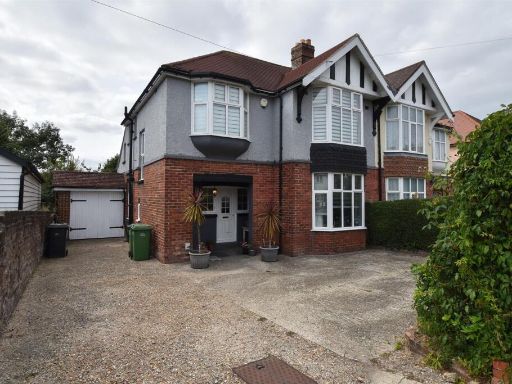 3 bedroom semi-detached house for sale in Sedlescombe Road North, St. Leonards-On-Sea, TN37 — £375,000 • 3 bed • 1 bath • 1386 ft²
 3 bedroom semi-detached house for sale in Oxford Road, St. Leonards-On-Sea, TN38 — £299,950 • 3 bed • 2 bath • 1157 ft²
 4 bedroom semi-detached house for sale in Madeira Drive, Hastings, TN34 — £374,000 • 4 bed • 2 bath • 824 ft²
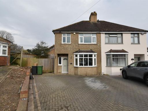 3 bedroom semi-detached house for sale in Lower Glen Road, St. Leonards-On-Sea, TN37 — £290,000 • 3 bed • 1 bath • 810 ft²
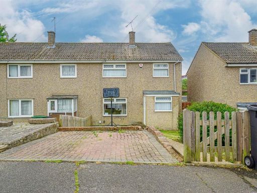 3 bedroom end of terrace house for sale in Sydney Close, St. Leonards-On-Sea, TN38 — £230,000 • 3 bed • 1 bath • 851 ft²
Meta
- {
"@context": "https://schema.org",
"@type": "Residence",
"name": "3 bedroom semidetached house for sale in Normandy Road, Has…",
"description": "",
"url": "https://propertypiper.co.uk/property/5bed2a27-d1b5-4b46-a7c2-22ba93c27f8b",
"image": "https://image-a.propertypiper.co.uk/84fbc416-b217-439c-a6c6-efab67f135a6-1024.jpeg",
"address": {
"@type": "PostalAddress",
"streetAddress": "4, Normandy Road, HASTINGS",
"postalCode": "TN34 2ND",
"addressLocality": "Hastings",
"addressRegion": "Hastings and Rye",
"addressCountry": "England"
},
"geo": {
"@type": "GeoCoordinates",
"latitude": 50.87123401450704,
"longitude": 0.5591126632561688
},
"numberOfRooms": 3,
"numberOfBathroomsTotal": 1,
"floorSize": {
"@type": "QuantitativeValue",
"value": 520,
"unitCode": "FTK"
},
"offers": {
"@type": "Offer",
"price": 325000,
"priceCurrency": "GBP",
"availability": "https://schema.org/InStock"
},
"additionalProperty": [
{
"@type": "PropertyValue",
"name": "Feature",
"value": "semi-detached"
},
{
"@type": "PropertyValue",
"name": "Feature",
"value": "1930s"
},
{
"@type": "PropertyValue",
"name": "Feature",
"value": "period"
},
{
"@type": "PropertyValue",
"name": "Feature",
"value": "brick exterior"
},
{
"@type": "PropertyValue",
"name": "Feature",
"value": "garage"
},
{
"@type": "PropertyValue",
"name": "Feature",
"value": "garden"
},
{
"@type": "PropertyValue",
"name": "Feature",
"value": "three-bedroom"
},
{
"@type": "PropertyValue",
"name": "Feature",
"value": "suburban"
},
{
"@type": "PropertyValue",
"name": "Feature",
"value": "family home"
},
{
"@type": "PropertyValue",
"name": "Feature",
"value": "off-street parking"
},
{
"@type": "PropertyValue",
"name": "Feature",
"value": "gable roof"
},
{
"@type": "PropertyValue",
"name": "Feature",
"value": "garden"
},
{
"@type": "PropertyValue",
"name": "Feature",
"value": "overgrown"
},
{
"@type": "PropertyValue",
"name": "Feature",
"value": "landscaping"
},
{
"@type": "PropertyValue",
"name": "Feature",
"value": "tree"
},
{
"@type": "PropertyValue",
"name": "Feature",
"value": "grass"
},
{
"@type": "PropertyValue",
"name": "Feature",
"value": "fence"
},
{
"@type": "PropertyValue",
"name": "Feature",
"value": "unkempt"
},
{
"@type": "PropertyValue",
"name": "Feature",
"value": "natural"
},
{
"@type": "PropertyValue",
"name": "Feature",
"value": "outdoor space"
}
]
}
High Res Floorplan Images
Compatible Floorplan Images
FloorplanImages Thumbnail