S21 4BX - 3 bedroom detached house for sale in Fenton Street, Eckingt…
View on Property Piper
3 bedroom detached house for sale in Fenton Street, Eckington, Sheffield, S21
Property Details
- Price: £350000
- Bedrooms: 3
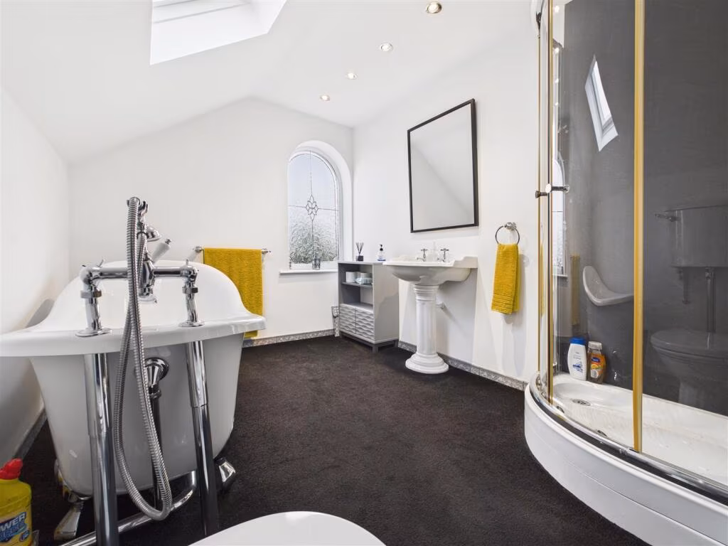
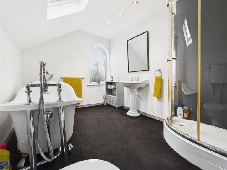
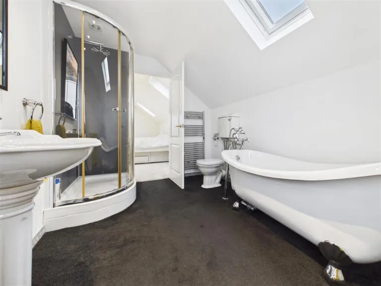
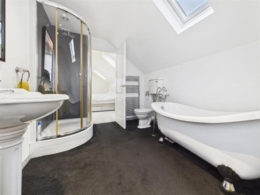
- Bathrooms: 2
- Property Type: undefined
- Property SubType: undefined
Brochure Descriptions
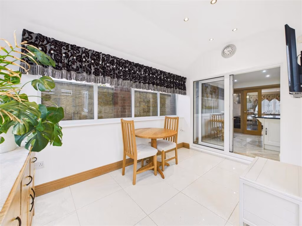
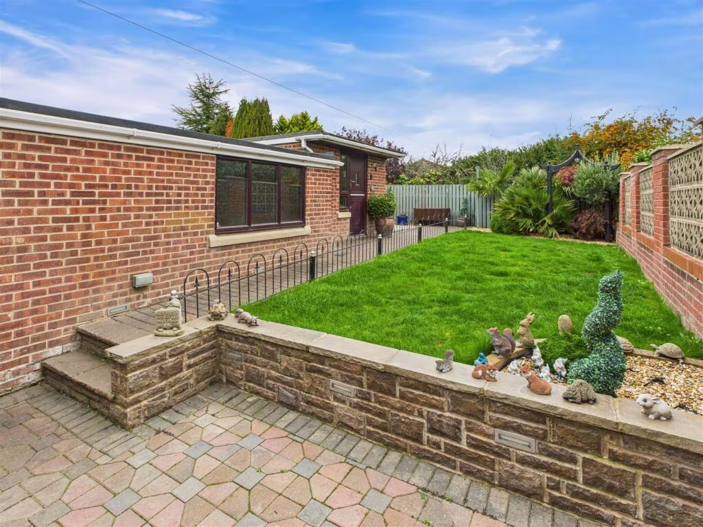
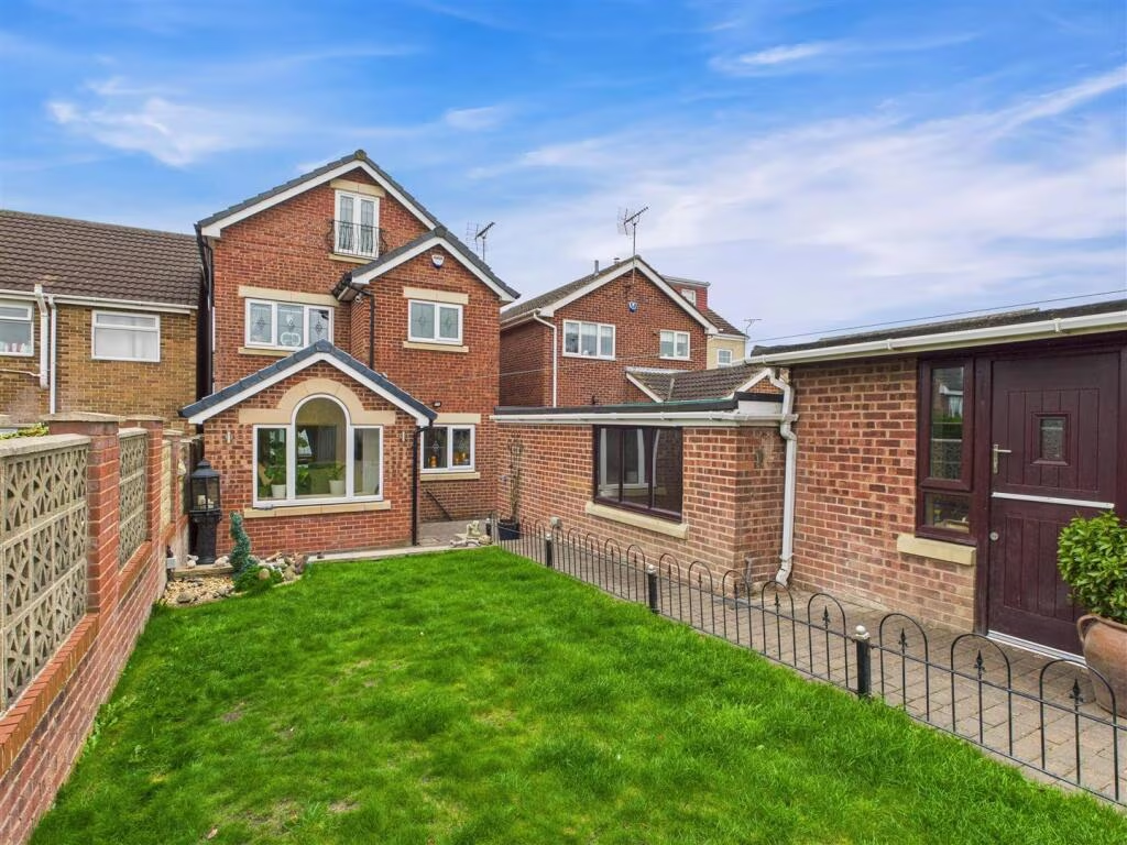
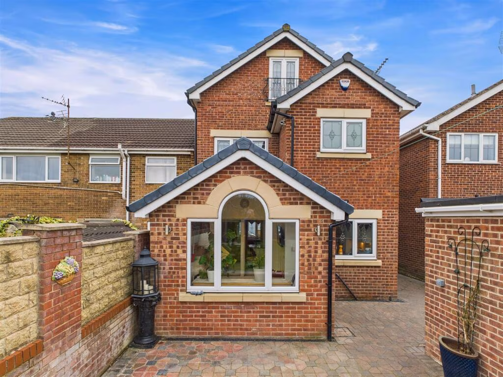
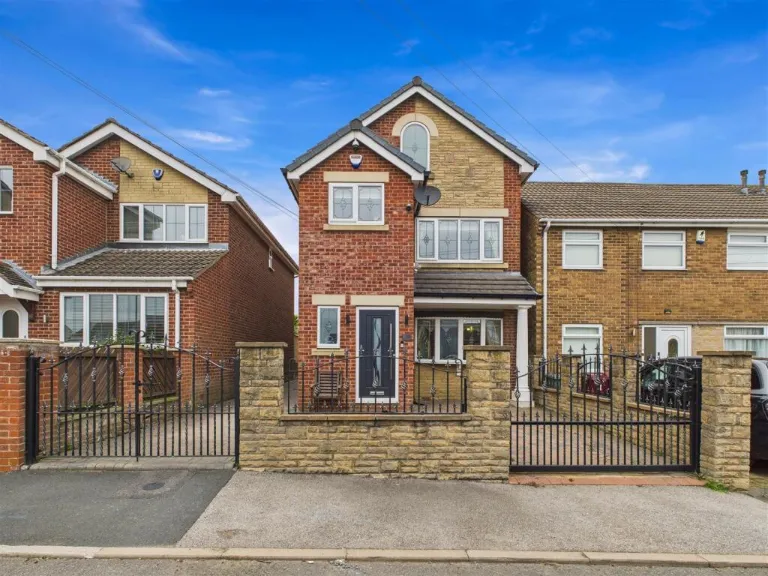
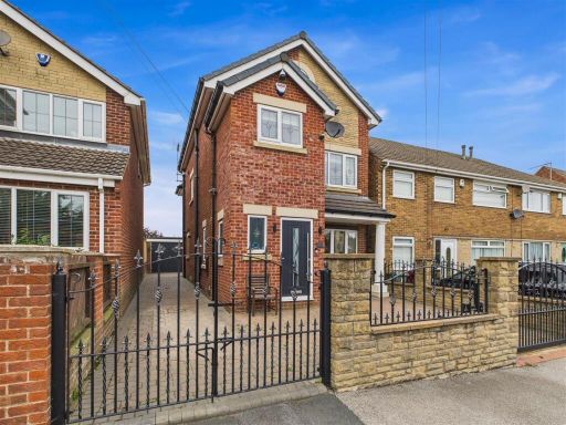
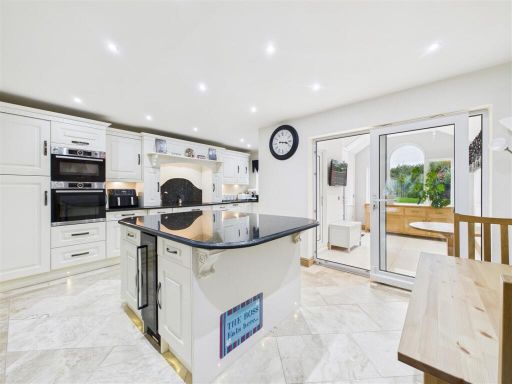
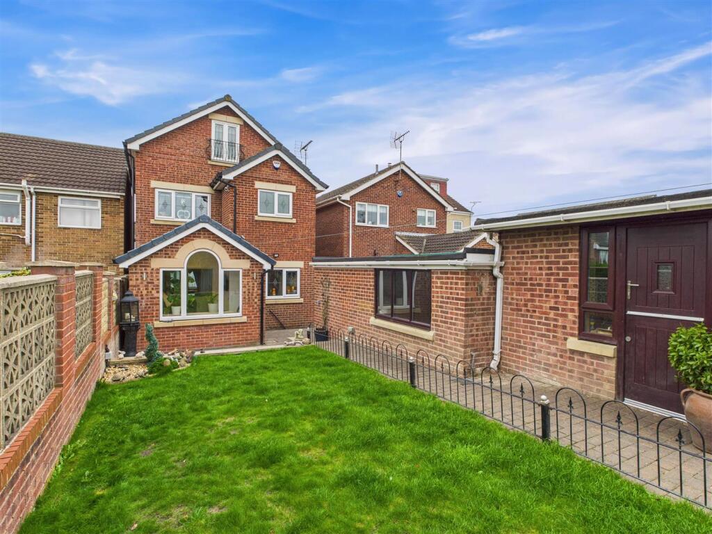
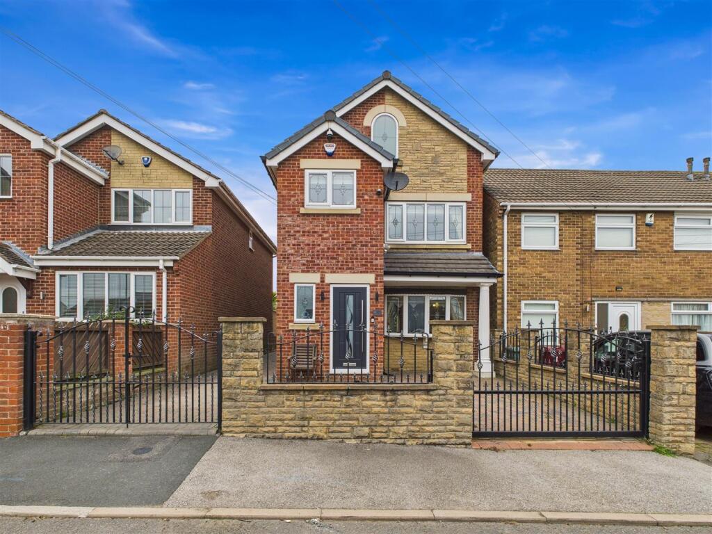
- Detached two-storey red-brick dwelling with pitched roof and gable to the front. The property sits on a narrow, paved plot with a gated front boundary and paved driveway leading alongside the house to a rear garage. Exterior finishes include modern double‑glazed windows and a contemporary front door. The plot appears to be small-to-average in width with limited front garden space (predominantly hardscaped) and likely a modest rear garden beyond the garage. Overall footprint suggests a mid-sized family home in good external condition, suitable for 2–4 bedrooms; street-facing aspect onto a residential road with neighbouring semi-detached/terraced properties. No notable views (urban/suburban setting).
- The provided image appears to be a brochure cover or blank page with only the estate agent's footer visible (Saxton Mee branch contact details). No photograph or identifiable features of the property for sale are shown, so it is not possible to describe internal layout, number of rooms, external grounds, aspect or views from this image. Room/garden size and overall property size cannot be inferred.
Image Descriptions
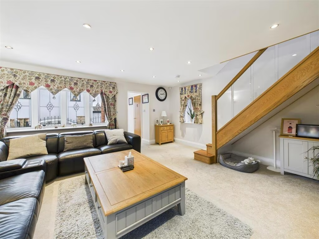
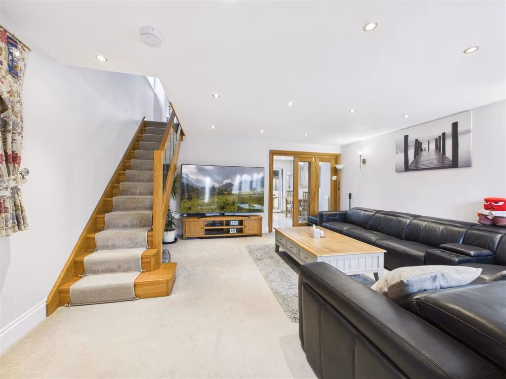
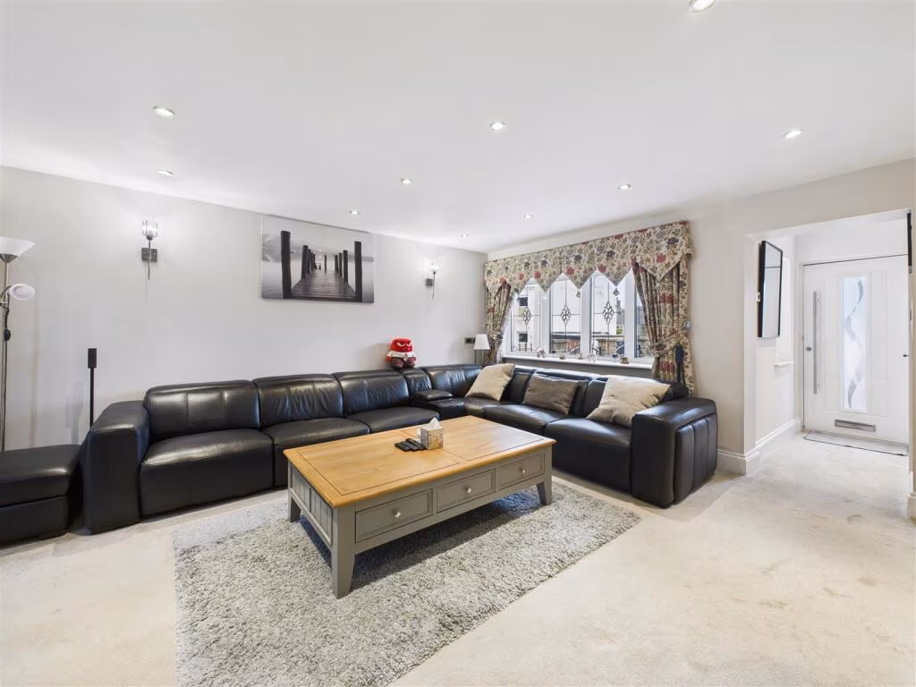
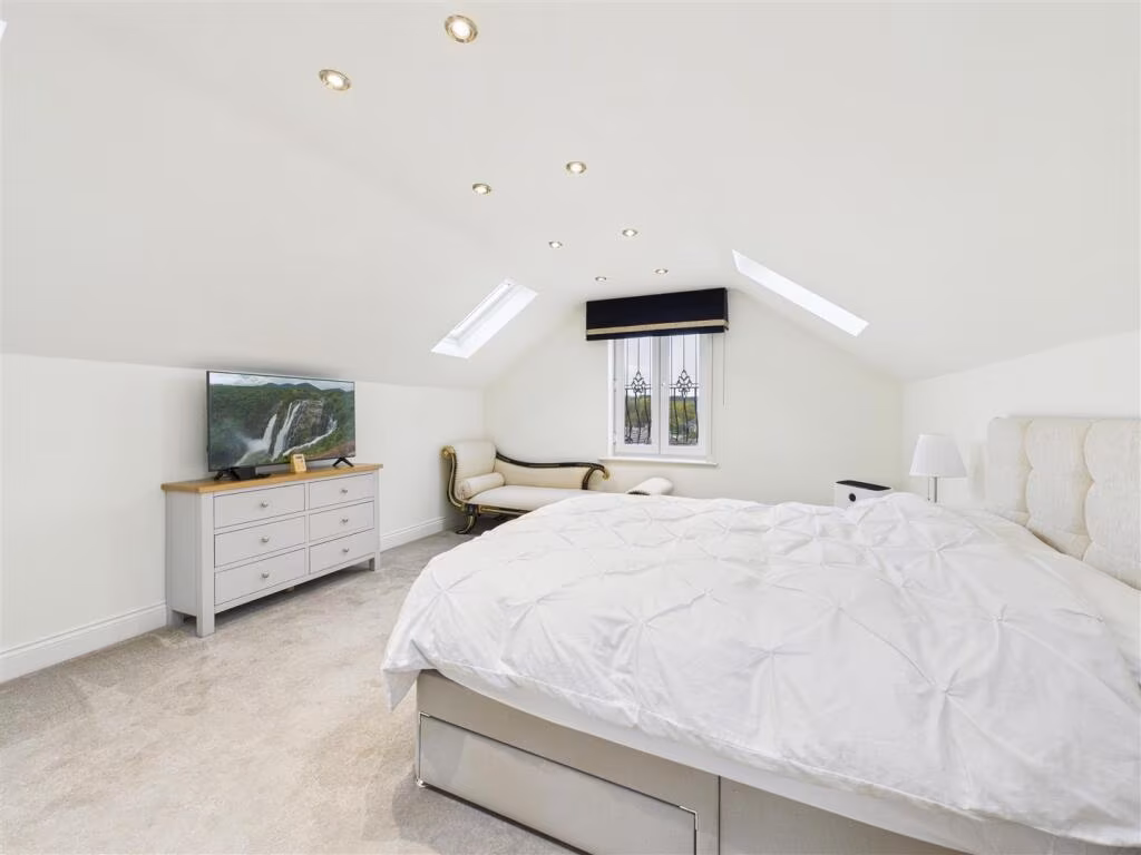
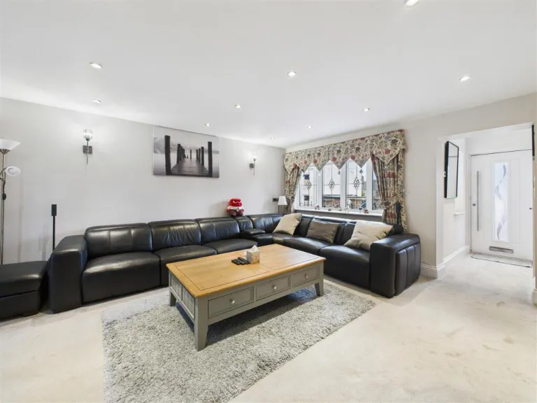
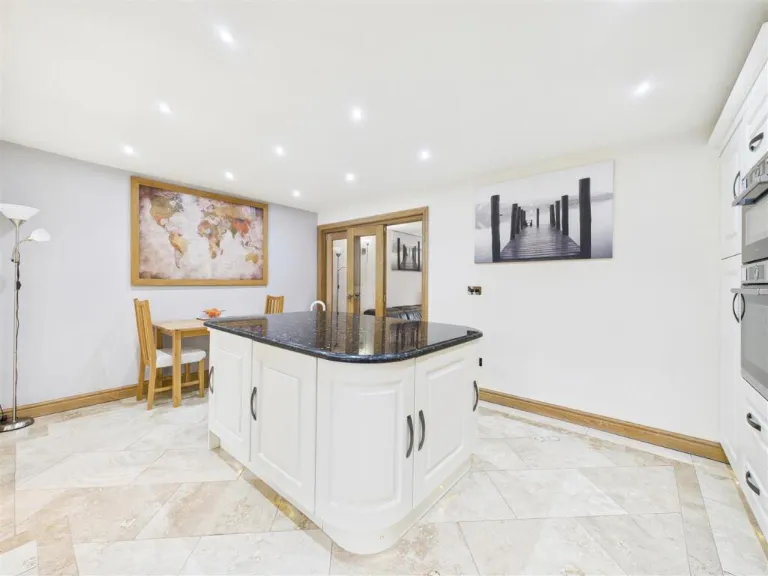
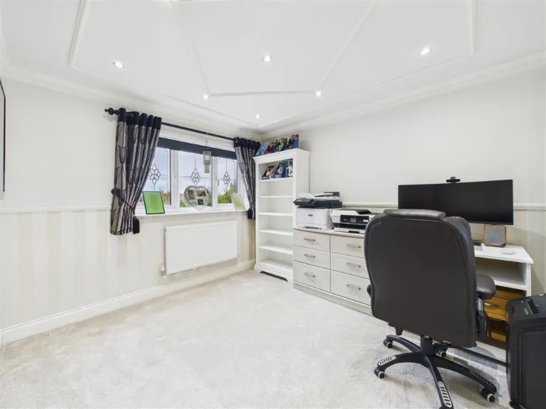
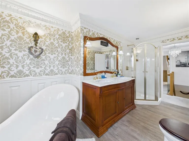
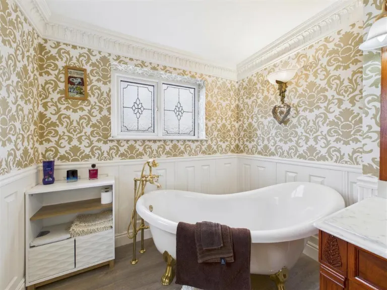
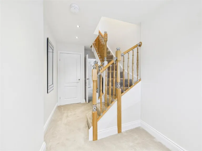
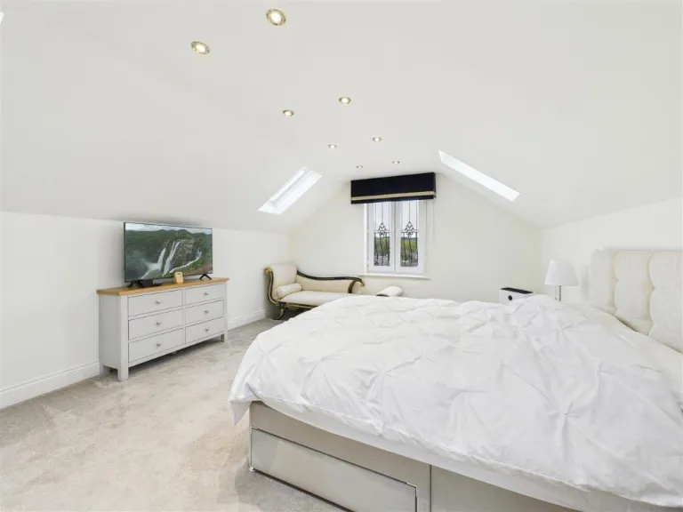
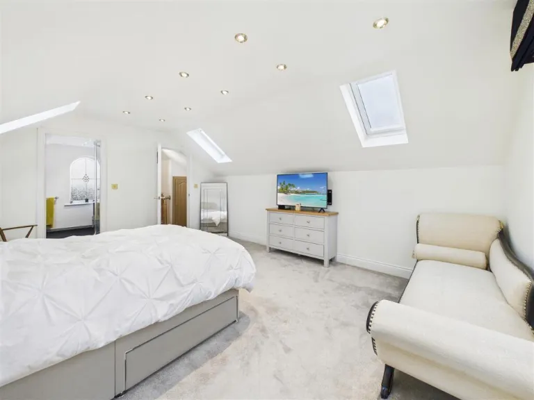
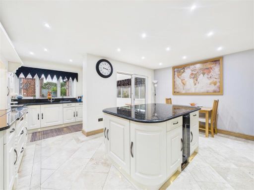
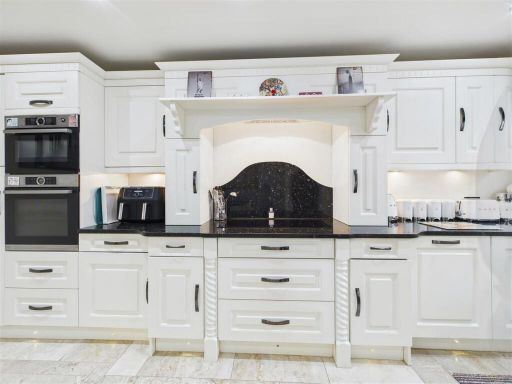
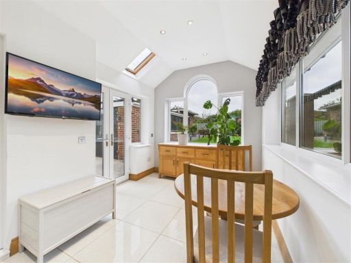
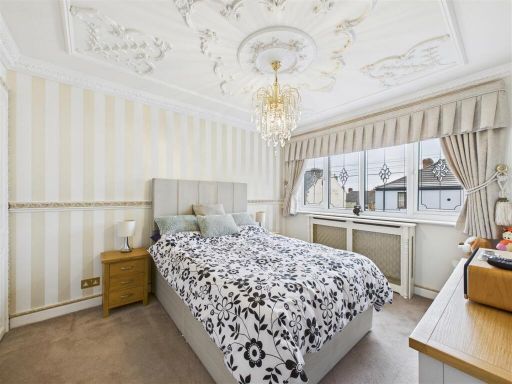
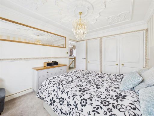
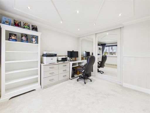
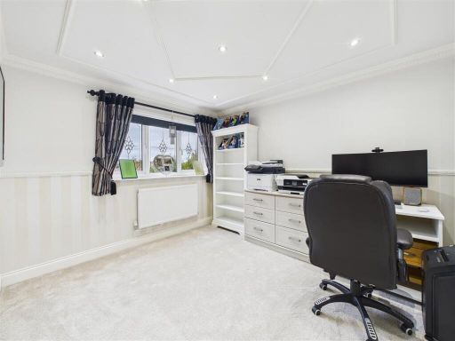
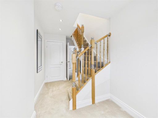
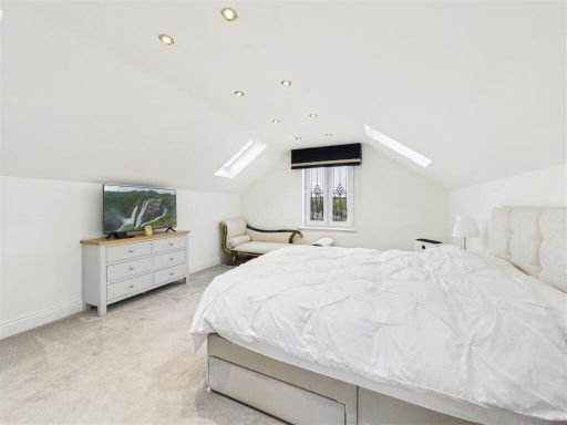
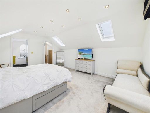
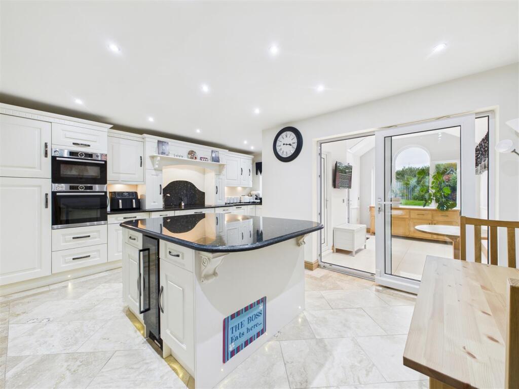
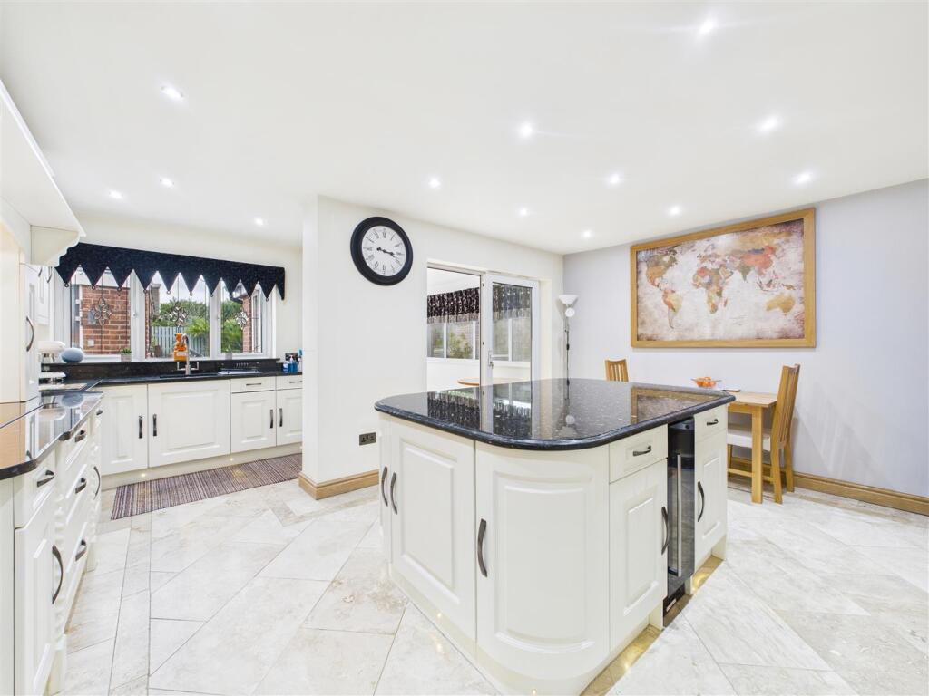
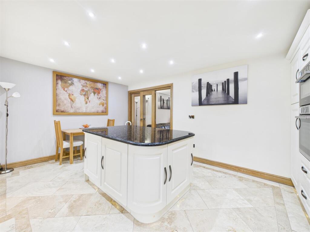
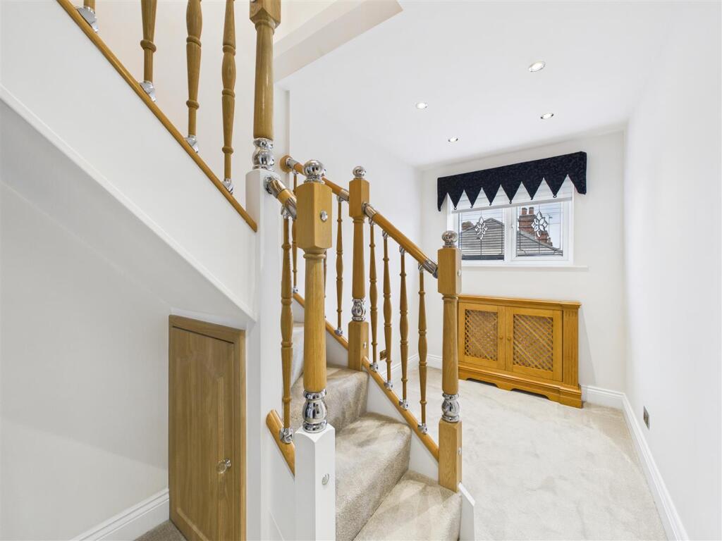
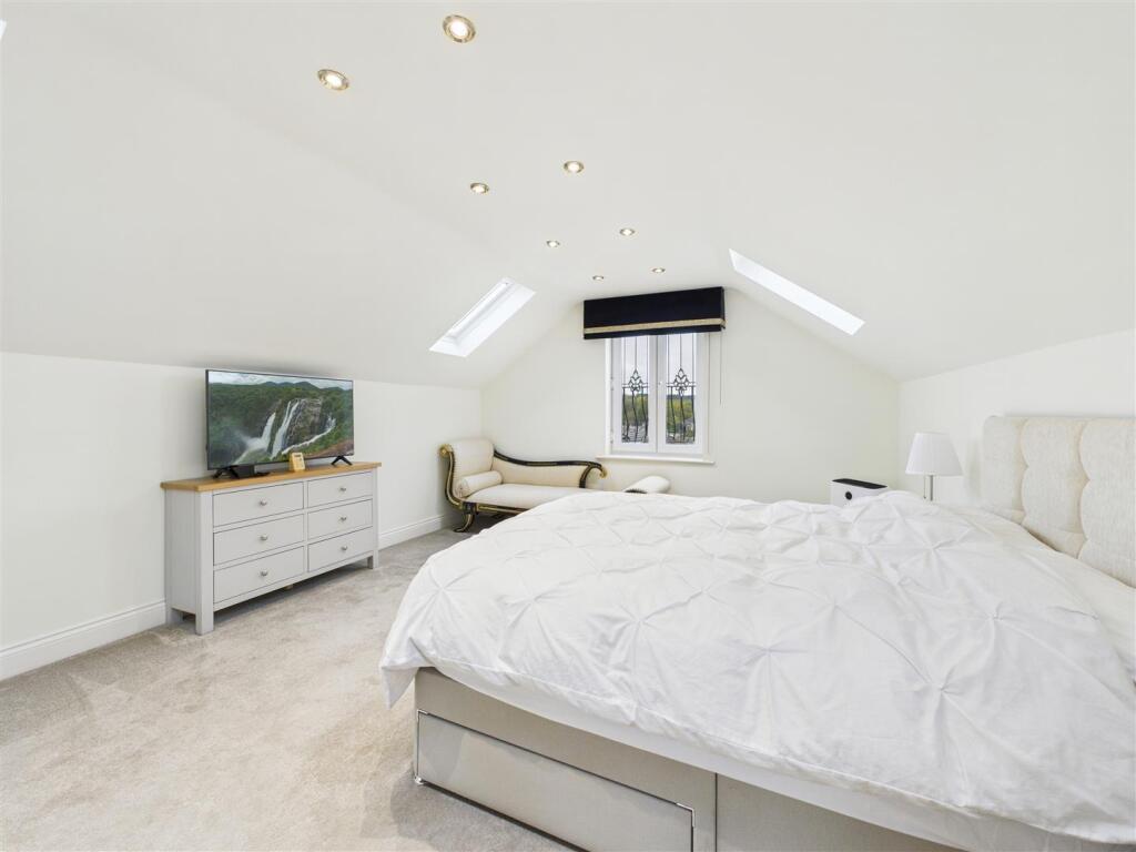
- modern detached house contemporary
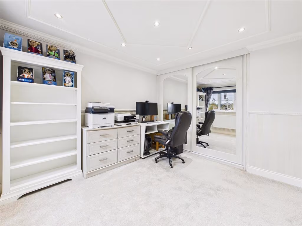
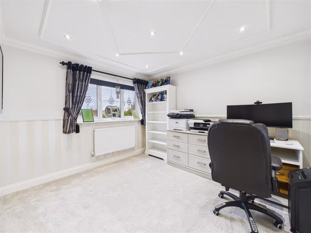
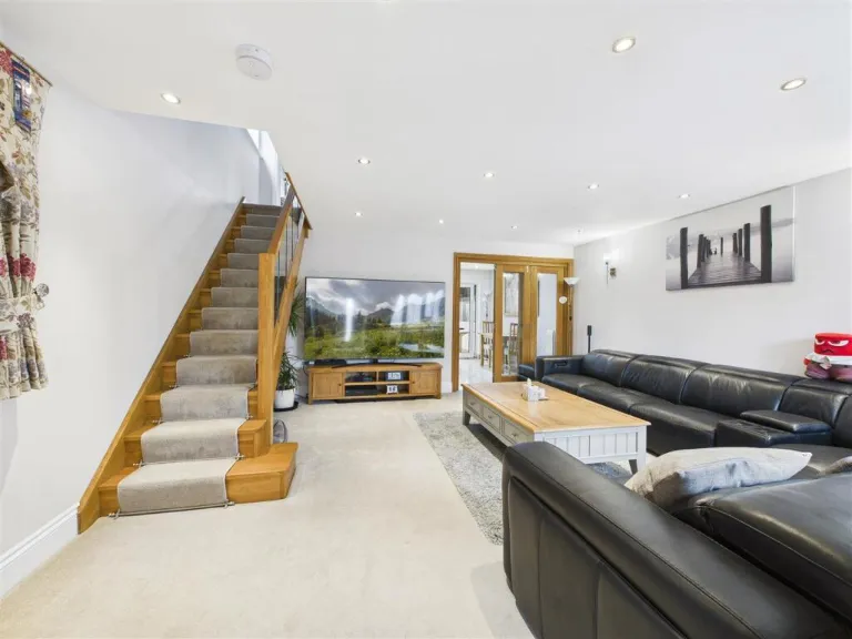
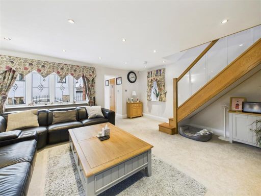
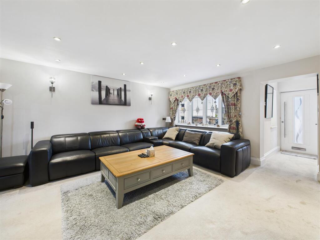
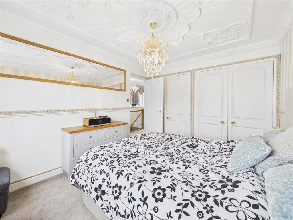
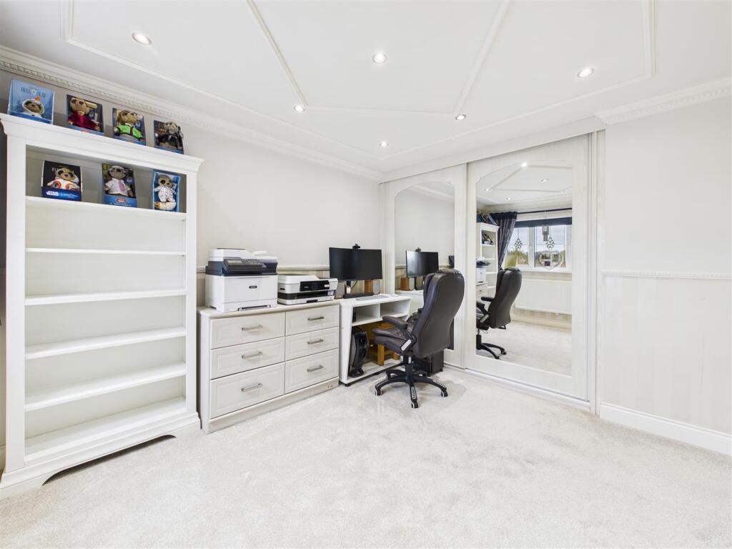
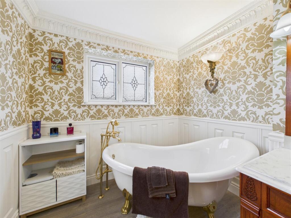
- Living Room Modern
Textual Property Features
Detected Visual Features
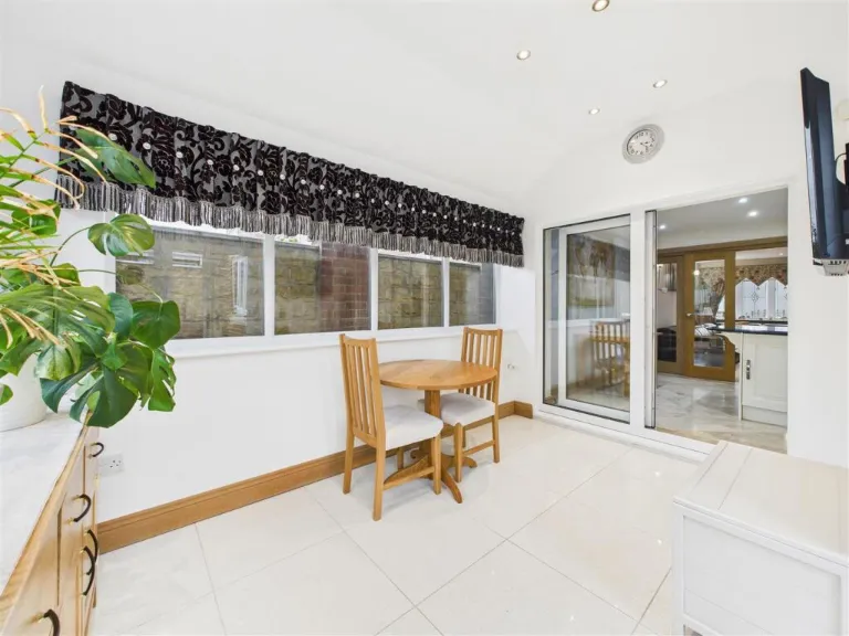
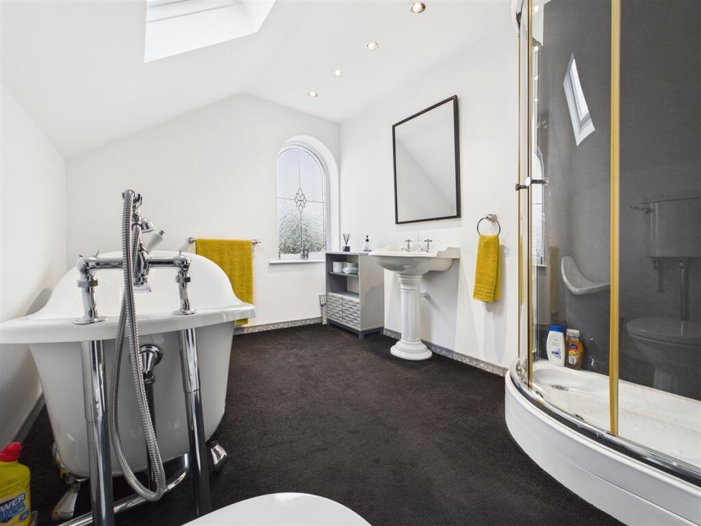
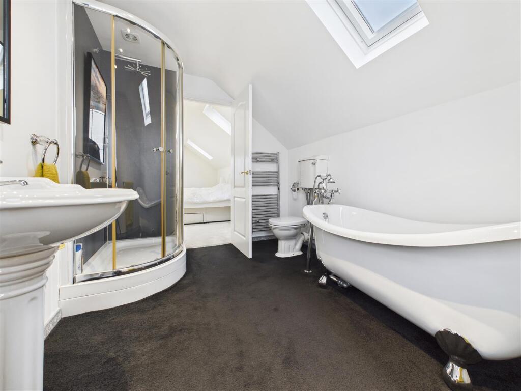
- modern house
- brick exterior
- detached
- gated
- driveway
- low maintenance
- fence
- two-story
- modern
- living room
- medium size
- staircase
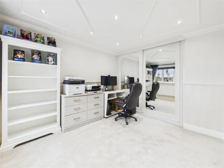
- bright
- well-maintained
- open concept
- window
- hardwood
- clean
- residential
EPC Details
- Fully double glazed
- Cavity wall, filled cavity
- Boiler and radiators, mains gas
- Low energy lighting in all fixed outlets
- Suspended, no insulation (assumed)
Nearby Schools
- Springwell Community College
- St Joseph's Catholic and CofE (VA) Primary School
- Marsh Lane Primary School
- Birley Spa Primary Academy
- Henry Bradley Infant School
- Hollingwood Primary School
- Birk Hill Infant & Nursery School
- Halfway Junior School
- Shortbrook Primary School
- Waterthorpe Infant School
- Birley Primary Academy
- Rainbow Forge Primary Academy
- Speedwell Infant School
- New Whittington Community Primary School
- Renishaw Primary School
- Eckington School
- Mosborough Primary School
- Ridgeway Primary School
- The Birley Academy
- St John Fisher Primary, A Catholic Voluntary Academy
- Inkersall Spencer Academy
- Staveley Junior School
- Netherthorpe School
- Eckington Junior School
- Camms CofE (Aided) Primary School
- Halfway Nursery Infant School
- Emmanuel Anglican/Methodist Junior School
- Westfield School
Nearest Bars And Restaurants
- Id: 392438325
- Tags:
- Amenity: pub
- Building: yes
- Name: Fox and Hounds
- TagsNormalized:
- Lat: 53.3080215
- Lon: -1.3898646
- FullGeoHash: gcrp227vtz3y
- PartitionGeoHash: gcrp
- Images:
- FoodStandards: null
- Distance: 1011.4
,- Id: 397110355
- Tags:
- Amenity: pub
- Building: yes
- Description:
- Name: Rose and Crown
- Outdoor_seating: yes
- Parking: yes
- Real_ale: no
- TagsNormalized:
- Lat: 53.307612
- Lon: -1.365674
- FullGeoHash: gcrp2bme37pe
- PartitionGeoHash: gcrp
- Images:
- FoodStandards: null
- Distance: 715.7
,- Id: 390506898
- Tags:
- Addr:
- City: Eckington
- Housenumber: 82
- Postcode: S21 4JN
- Street: Ravencar Road
- Amenity: fast_food
- Delivery: yes
- Drive_through: no
- Name: UK Pizza
- Source: https://take-a-way.co.uk/browse-restaurants/City-Eckington/
- Takeaway: yes
- Website: https://take-a-way.co.uk/menu/6957/UK%20Pizza%20-%20Eckington/
- TagsNormalized:
- fast food
- food
- pizza
- takeaway
- Lat: 53.3083057
- Lon: -1.3744125
- FullGeoHash: gcrp28rpmu7v
- PartitionGeoHash: gcrp
- Images:
- FoodStandards: null
- Distance: 375.7
,- Id: 390506900
- Tags:
- Addr:
- City: Eckington
- Housenumber: 78
- Postcode: S21 4JN
- Street: Ravencar Road
- Amenity: fast_food
- Cuisine: chinese
- Delivery: yes
- Drive_through: no
- Name: Aichi Chinese
- Source: https://take-a-way.co.uk/browse-restaurants/City-Eckington/
- Takeaway: yes
- Website: https://take-a-way.co.uk/menu/8558/Aichi%20Chinese%20-%20Eckington/
- TagsNormalized:
- fast food
- food
- chinese
- takeaway
- Lat: 53.3081765
- Lon: -1.3746077
- FullGeoHash: gcrp28rn9k65
- PartitionGeoHash: gcrp
- Images:
- FoodStandards: null
- Distance: 359.2
,- Id: 395553997
- Tags:
- Amenity: cafe
- Building: yes
- Name: Penelope's Pit Stop
- TagsNormalized:
- Lat: 53.305277
- Lon: -1.3742656
- FullGeoHash: gcrp0xzm9rc7
- PartitionGeoHash: gcrp
- Images:
- FoodStandards: null
- Distance: 88.7
}
Nearest General Shops
- Id: 507832703
- Tags:
- Name: Roystons Auto Centre
- Shop: car
- TagsNormalized:
- Lat: 53.3061049
- Lon: -1.3673521
- FullGeoHash: gcrp2bh6d6hm
- PartitionGeoHash: gcrp
- Images:
- FoodStandards: null
- Distance: 556.2
,- Id: 334577090
- Tags:
- Name: Quarry Top
- Shop: garden_centre
- TagsNormalized:
- Lat: 53.3006266
- Lon: -1.3795466
- FullGeoHash: gcrp0x56whzq
- PartitionGeoHash: gcrp
- Images:
- FoodStandards: null
- Distance: 554.4
,- Id: 507832702
- Tags:
- Name: Eckington Car Sales
- Shop: car
- TagsNormalized:
- Lat: 53.3059229
- Lon: -1.3678329
- FullGeoHash: gcrp2b5cx0mb
- PartitionGeoHash: gcrp
- Images:
- FoodStandards: null
- Distance: 520.7
}
Nearest Grocery shops
- Id: 390461648
- Tags:
- Name: Birkhill Convenience Store
- Shop: convenience
- TagsNormalized:
- Lat: 53.3025554
- Lon: -1.3710693
- FullGeoHash: gcrp0z3tgu88
- PartitionGeoHash: gcrp
- Images:
- FoodStandards: null
- Distance: 400.7
,- Id: 397492053
- Tags:
- Brand: One Stop
- Brand:wikidata: Q65954217
- Building: yes
- Disused:
- Name: One Stop
- Old_name: The West End
- Shop: convenience
- TagsNormalized:
- Lat: 53.3056839
- Lon: -1.3697962
- FullGeoHash: gcrp2b4817ty
- PartitionGeoHash: gcrp
- Images:
- FoodStandards: null
- Distance: 387.6
,- Id: 390506899
- Tags:
- Name: Harry's General Store
- Shop: convenience
- TagsNormalized:
- Lat: 53.3082518
- Lon: -1.3744933
- FullGeoHash: gcrp28rp5frs
- PartitionGeoHash: gcrp
- Images:
- FoodStandards: null
- Distance: 368.8
}
Nearest Supermarkets
- Id: 145313218
- Tags:
- Brand: Morrisons
- Brand:wikidata: Q922344
- Brand:wikipedia: en:Morrisons
- Building: retail
- Contact:
- Website: https://my.morrisons.com/storefinder/27
- Name: Morrisons
- Opening_hours: Mo-Sa 07:00-21:00; Su 10:00-16:00
- Operator: Morrisons
- Shop: supermarket
- Source: Bing
- TagsNormalized:
- morrisons
- retail
- supermarket
- shop
- Lat: 53.2679356
- Lon: -1.35389
- FullGeoHash: gcrp11nhhnfk
- PartitionGeoHash: gcrp
- Images:
- FoodStandards: null
- Distance: 4363.9
,- Id: 71213950
- Tags:
- Addr:
- City: Sheffield
- Postcode: S20 8GN
- Street: Oxclose Park Road North
- Brand: Morrisons
- Brand:wikidata: Q922344
- Brand:wikipedia: en:Morrisons
- Building: supermarket
- Name: Morrisons
- Shop: supermarket
- Website: https://my.morrisons.com/storefinder/101
- TagsNormalized:
- Lat: 53.3251595
- Lon: -1.3431174
- FullGeoHash: gcrp37tcx45n
- PartitionGeoHash: gcrp
- Images:
- FoodStandards: null
- Distance: 3108.1
,- Id: 9657826676
- Tags:
- Addr:
- Housenumber: 21
- Postcode: S21 4EF
- Street: Littlemoor
- Brand: ALDI
- Brand:wikidata: Q41171672
- Brand:wikipedia: en:Aldi
- Contact:
- Website: https://stores.aldi.co.uk/eckington/21-littlemoor
- Fhrs:
- Name: ALDI
- Operator: Aldi Stores Limited
- Shop: supermarket
- TagsNormalized:
- Lat: 53.3106631
- Lon: -1.351034
- FullGeoHash: gcrp32bjneuh
- PartitionGeoHash: gcrp
- Images:
- FoodStandards:
- Id: 1073419
- FHRSID: 1073419
- LocalAuthorityBusinessID: 18/00153/COMM
- BusinessName: Aldi Stores Ltd
- BusinessType: Retailers - supermarkets/hypermarkets
- BusinessTypeID: 7840
- AddressLine1: Aldi Foodstore
- AddressLine2: 21 Littlemoor
- AddressLine3: Eckington
- AddressLine4: Sheffield
- PostCode: S21 4EF
- RatingValue: 5
- RatingKey: fhrs_5_en-GB
- RatingDate: 2022-08-16
- LocalAuthorityCode: 068
- LocalAuthorityName: North East Derbyshire
- LocalAuthorityWebSite: http://www.ne-derbyshire.gov.uk/
- LocalAuthorityEmailAddress: envhealth@ne-derbyshire.gov.uk
- Scores:
- Hygiene: 0
- Structural: 0
- ConfidenceInManagement: 0
- NewRatingPending: false
- Geocode:
- Longitude: -1.35133397579193
- Latitude: 53.31113433837890
- Distance: 1744.4
}
Nearest Religious buildings
- Id: 397110357
- Tags:
- Amenity: place_of_worship
- Building: yes
- Name: Eckington Friendship Hall
- TagsNormalized:
- Lat: 53.3073451
- Lon: -1.3659603
- FullGeoHash: gcrp2bm3fc65
- PartitionGeoHash: gcrp
- Images:
- FoodStandards: null
- Distance: 686.5
,- Id: 395562958
- Tags:
- Amenity: place_of_worship
- Building: church
- Denomination: anglican
- Name: St Luke
- Religion: christian
- Wikidata: Q105094377
- TagsNormalized:
- place of worship
- church
- anglican
- christian
- Lat: 53.305509
- Lon: -1.3728059
- FullGeoHash: gcrp0zbr571e
- PartitionGeoHash: gcrp
- Images:
- FoodStandards: null
- Distance: 188.8
,- Id: 390480605
- Tags:
- Amenity: place_of_worship
- Denomination: methodist
- Name: Eckington Methodist Church
- Religion: christian
- TagsNormalized:
- place of worship
- methodist
- church
- christian
- Lat: 53.3046372
- Lon: -1.3747807
- FullGeoHash: gcrp0xyfj294
- PartitionGeoHash: gcrp
- Images:
- FoodStandards: null
- Distance: 62.6
}
Nearest Medical buildings
- Id: 396201689
- Tags:
- Amenity: doctors
- Building: yes
- Healthcare: doctor
- Name: Eckington Medical Practice
- TagsNormalized:
- doctor
- doctors
- health
- healthcare
- Lat: 53.3074309
- Lon: -1.3549393
- FullGeoHash: gcrp30m679k5
- PartitionGeoHash: gcrp
- Images:
- FoodStandards: null
- Distance: 1393.6
,- Id: 396201686
- Tags:
- Amenity: pharmacy
- Building: yes
- Healthcare: pharmacy
- Name: Peak Pharmacy
- TagsNormalized:
- Lat: 53.3076688
- Lon: -1.3552891
- FullGeoHash: gcrp30m5emxn
- PartitionGeoHash: gcrp
- Images:
- FoodStandards: null
- Distance: 1376.3
,- Id: 1827575246
- Tags:
- Amenity: pharmacy
- Dispensing: yes
- Healthcare: pharmacy
- Name: peak pharmacy
- TagsNormalized:
- Lat: 53.3095451
- Lon: -1.3564187
- FullGeoHash: gcrp30sq95kz
- PartitionGeoHash: gcrp
- Images:
- FoodStandards: null
- Distance: 1365.9
,- Id: 396196567
- Tags:
- Amenity: dentist
- Building: yes
- Healthcare: dentist
- Name: Eckington Dental Surgery
- TagsNormalized:
- dentist
- health
- healthcare
- dental
- surgery
- Lat: 53.309131
- Lon: -1.3572911
- FullGeoHash: gcrp30eshy63
- PartitionGeoHash: gcrp
- Images:
- FoodStandards: null
- Distance: 1295.2
}
Nearest Airports
- Id: 100889514
- Tags:
- Addr:
- Aerodrome: international
- Aerodrome:type: public
- Area: yes
- Cities_served: Doncaster, Sheffield
- Closest_town: Doncaster
- Disused:
- Ele: 17
- Iata: DSA
- Icao: EGCN
- Ifr: yes
- Is_in: Finningley
- Name: Doncaster Sheffield Airport
- Old_iata: FNY
- Old_icao: EGXI
- Old_name: RAF Finningley
- Old_operator: Royal Air Force
- Old_type: military
- Operator: Doncaster Sheffield Airport Limited/Peel Airports
- Source: wikipedia
- Tower_frequency: 128.775
- Vfr: yes
- Website: https://www.robinhoodairport.com/
- Wikidata: Q8996
- Wikipedia: en:Robin Hood Airport Doncaster Sheffield
- TagsNormalized:
- airport
- international airport
- Lat: 53.4761577
- Lon: -1.0054086
- FullGeoHash: gcx21p5chq34
- PartitionGeoHash: gcx2
- Images:
- FoodStandards: null
- Distance: 31057.5
}
Nearest Leisure Facilities
- Id: 398386805
- Tags:
- TagsNormalized:
- Lat: 53.3077266
- Lon: -1.3685523
- FullGeoHash: gcrp2b7kn2mr
- PartitionGeoHash: gcrp
- Images:
- FoodStandards: null
- Distance: 553.5
,- Id: 1324407072
- Tags:
- TagsNormalized:
- Lat: 53.3076957
- Lon: -1.3685984
- FullGeoHash: gcrp2b77v6ep
- PartitionGeoHash: gcrp
- Images:
- FoodStandards: null
- Distance: 549.1
,- Id: 34299973
- Tags:
- TagsNormalized:
- Lat: 53.308187
- Lon: -1.3700314
- FullGeoHash: gcrp2b6qeyq9
- PartitionGeoHash: gcrp
- Images:
- FoodStandards: null
- Distance: 508.8
,- Id: 335001636
- Tags:
- TagsNormalized:
- Lat: 53.3046207
- Lon: -1.3799489
- FullGeoHash: gcrp0xg1uve8
- PartitionGeoHash: gcrp
- Images:
- FoodStandards: null
- Distance: 297.6
,- Id: 335001632
- Tags:
- TagsNormalized:
- Lat: 53.3043721
- Lon: -1.378192
- FullGeoHash: gcrp0xu2mz1t
- PartitionGeoHash: gcrp
- Images:
- FoodStandards: null
- Distance: 190.9
}
Nearest Tourist attractions
- Id: 4731691
- Tags:
- Building: yes
- Tourism: museum
- Type: multipolygon
- TagsNormalized:
- Lat: 53.3027376
- Lon: -1.3468502
- FullGeoHash: gcrp1r7qbn7w
- PartitionGeoHash: gcrp
- Images:
- FoodStandards: null
- Distance: 1920.9
,- Id: 162040460
- Tags:
- Name: Bramley Park
- Source: Bing
- Tourism: caravan_site
- TagsNormalized:
- Lat: 53.309021
- Lon: -1.3883404
- FullGeoHash: gcrp22t593f2
- PartitionGeoHash: gcrp
- Images:
- FoodStandards: null
- Distance: 962.9
,- Id: 390506883
- Tags:
- Name: Ravencar Farm Bed & Breakfast
- Postal_code: S21 5RH
- Tourism: guest_house
- TagsNormalized:
- bed
- farm
- guest house
- tourism
- Lat: 53.3068305
- Lon: -1.3812472
- FullGeoHash: gcrp284ny97q
- PartitionGeoHash: gcrp
- Images:
- FoodStandards: null
- Distance: 432.4
}
Nearest Train stations
- Id: 7154300845
- Tags:
- Name: Chesterfield
- Naptan:
- Network: National Rail
- Public_transport: station
- Railway: station
- Ref:
- Wikidata: Q2645921
- Wikipedia: en:Chesterfield railway station
- TagsNormalized:
- Lat: 53.2382236
- Lon: -1.4197283
- FullGeoHash: gcqyzewpjujv
- PartitionGeoHash: gcqy
- Images:
- FoodStandards: null
- Distance: 7985.2
,- Id: 3157353528
- Tags:
- Name: Woodhouse
- Naptan:
- Network: National Rail
- Operator: Northern Rail
- Public_transport: station
- Railway: station
- Ref:
- Source: wikipedia
- Wikidata: Q2497249
- Wikipedia: en:Woodhouse railway station
- TagsNormalized:
- Lat: 53.3637962
- Lon: -1.3573689
- FullGeoHash: gcrp94edeh87
- PartitionGeoHash: gcrp
- Images:
- FoodStandards: null
- Distance: 6648.9
,- Id: 370186628
- Tags:
- Name: Dronfield
- Naptan:
- Network: National Rail
- Platforms: 2
- Public_transport: station
- Railway: station
- Ref:
- Wikidata: Q2161199
- Wikipedia: en:Dronfield railway station
- TagsNormalized:
- Lat: 53.3014
- Lon: -1.4692529
- FullGeoHash: gcqznx4p5vje
- PartitionGeoHash: gcqz
- Images:
- FoodStandards: null
- Distance: 6241.6
,- Id: 102031003
- Tags:
- Building: train_station
- Name: Barrow Hill Roundhouse
- Railway: turntable
- Tourism: attraction
- Wikidata: Q4863884
- Wikipedia: en:Barrow Hill Engine Shed
- TagsNormalized:
- station
- train
- train station
- railway
- attraction
- tourism
- Lat: 53.2744292
- Lon: -1.381839
- FullGeoHash: gcrp0d3f0c6h
- PartitionGeoHash: gcrp
- Images:
- FoodStandards: null
- Distance: 3424.3
,- Id: 1716256015
- Tags:
- Name: Roundhouse Halt
- Public_transport: station
- Railway: station
- Usage: tourism
- Website: https://www.barrowhill.org/
- TagsNormalized:
- Lat: 53.2746594
- Lon: -1.3813376
- FullGeoHash: gcrp0d65ks21
- PartitionGeoHash: gcrp
- Images:
- FoodStandards: null
- Distance: 3394.9
}
Nearest Bus stations and stops
- Id: 4632144680
- Tags:
- Bus: yes
- Highway: bus_stop
- Public_transport: platform
- Shelter: yes
- TagsNormalized:
- Lat: 53.3059209
- Lon: -1.3694583
- FullGeoHash: gcrp2b4c3rcu
- PartitionGeoHash: gcrp
- Images:
- FoodStandards: null
- Distance: 415.3
,- Id: 390461650
- Tags:
- Bus: yes
- Highway: bus_stop
- Public_transport: platform
- TagsNormalized:
- Lat: 53.3026245
- Lon: -1.3709875
- FullGeoHash: gcrp0z3wm9ms
- PartitionGeoHash: gcrp
- Images:
- FoodStandards: null
- Distance: 399.6
,- Id: 390453705
- Tags:
- Bus: yes
- Highway: bus_stop
- Public_transport: platform
- TagsNormalized:
- Lat: 53.3022245
- Lon: -1.3755818
- FullGeoHash: gcrp0xq7fwgf
- PartitionGeoHash: gcrp
- Images:
- FoodStandards: null
- Distance: 307.7
,- Id: 390452542
- Tags:
- Bus: yes
- Highway: bus_stop
- Public_transport: platform
- TagsNormalized:
- Lat: 53.3036612
- Lon: -1.3746973
- FullGeoHash: gcrp0xwur4xk
- PartitionGeoHash: gcrp
- Images:
- FoodStandards: null
- Distance: 157.5
,- Id: 390452539
- Tags:
- Bus: yes
- Highway: bus_stop
- Public_transport: platform
- TagsNormalized:
- Lat: 53.303826
- Lon: -1.3752013
- FullGeoHash: gcrp0xwt73re
- PartitionGeoHash: gcrp
- Images:
- FoodStandards: null
- Distance: 131.2
}
Nearest Hotels
- Id: 335298006
- Tags:
- Building: yes
- Name: Sitwell Arms
- Tourism: hotel
- TagsNormalized:
- Lat: 53.2992754
- Lon: -1.3349786
- FullGeoHash: gcrp1wgfu9pf
- PartitionGeoHash: gcrp
- Images:
- FoodStandards: null
- Distance: 2767.4
,- Id: 343389600
- Tags:
- Addr:
- City: Sheffield
- Country: GB
- Postcode: S20 5EA
- Street: High Street
- Fhrs:
- Name: Mosborough Hall Hotel
- Operator: Best Westen
- Tourism: hotel
- TagsNormalized:
- Lat: 53.3215943
- Lon: -1.3567463
- FullGeoHash: gcrp34uhc98e
- PartitionGeoHash: gcrp
- Images:
- FoodStandards: null
- Distance: 2227.7
,- Id: 363773497
- Tags:
- Amenity: pub
- Building: yes
- Name: The Royal Hotel
- TagsNormalized:
- Lat: 53.3090001
- Lon: -1.3552534
- FullGeoHash: gcrp30t5kmcu
- PartitionGeoHash: gcrp
- Images:
- FoodStandards: null
- Distance: 1417.9
}
Tags
- modern house
- brick exterior
- detached
- gated
- driveway
- low maintenance
- fence
- two-story
- modern
- living room
- medium size
- staircase
- bright
- well-maintained
- open concept
- window
- hardwood
- clean
- residential
Local Market Stats
- Average Price/sqft: £210
- Avg Income: £38600
- Rental Yield: 3.8%
- Social Housing: 12%
- Planning Success Rate: 100%
Similar Properties
 4 bedroom detached house for sale in Chester Court, Eckington, Sheffield, S21 — £400,000 • 4 bed • 2 bath • 1824 ft²
 5 bedroom detached house for sale in St. Johns Road, Newbold, Chesterfield, S41 8PE, S41 — £775,000 • 5 bed • 5 bath • 3500 ft²
 3 bedroom detached house for sale in Wentworth Road, Dronfield Woodhouse, Dronfield, S18 — £325,000 • 3 bed • 2 bath • 1304 ft²
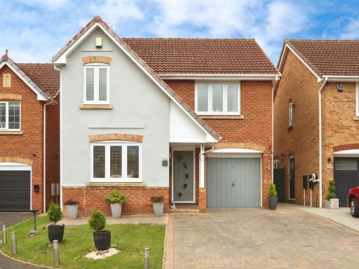 4 bedroom detached house for sale in Aintree Avenue, Eckington, Sheffield, Derbyshire, S21 — £400,000 • 4 bed • 2 bath • 1259 ft²
 4 bedroom detached house for sale in West Croft Court, Inkersall, Chesterfield, Derbyshire, S43 — £350,000 • 4 bed • 2 bath • 1237 ft²
 4 bedroom detached house for sale in Standall Close, Dronfield Woodhouse, S18 — £550,000 • 4 bed • 3 bath • 1721 ft²
Meta
- {
"@context": "https://schema.org",
"@type": "Residence",
"name": "3 bedroom detached house for sale in Fenton Street, Eckingt…",
"description": "",
"url": "https://propertypiper.co.uk/property/53d2842c-36e2-498f-80f7-a9f321e44b24",
"image": "https://image-a.propertypiper.co.uk/6fb6f142-ce18-4285-935f-d795a83c8196-1024.jpeg",
"address": {
"@type": "PostalAddress",
"streetAddress": "10, FENTON STREET, SHEFFIELD, ECKINGTON",
"postalCode": "S21 4BX",
"addressLocality": "North East Derbyshire",
"addressRegion": "North East Derbyshire",
"addressCountry": "England"
},
"geo": {
"@type": "GeoCoordinates",
"latitude": 53.3049914,
"longitude": -1.3755126
},
"numberOfRooms": 3,
"numberOfBathroomsTotal": 2,
"offers": {
"@type": "Offer",
"price": 350000,
"priceCurrency": "GBP",
"availability": "https://schema.org/InStock"
},
"additionalProperty": [
{
"@type": "PropertyValue",
"name": "Feature",
"value": "modern house"
},
{
"@type": "PropertyValue",
"name": "Feature",
"value": "brick exterior"
},
{
"@type": "PropertyValue",
"name": "Feature",
"value": "detached"
},
{
"@type": "PropertyValue",
"name": "Feature",
"value": "gated"
},
{
"@type": "PropertyValue",
"name": "Feature",
"value": "driveway"
},
{
"@type": "PropertyValue",
"name": "Feature",
"value": "low maintenance"
},
{
"@type": "PropertyValue",
"name": "Feature",
"value": "fence"
},
{
"@type": "PropertyValue",
"name": "Feature",
"value": "two-story"
},
{
"@type": "PropertyValue",
"name": "Feature",
"value": "modern"
},
{
"@type": "PropertyValue",
"name": "Feature",
"value": "living room"
},
{
"@type": "PropertyValue",
"name": "Feature",
"value": "medium size"
},
{
"@type": "PropertyValue",
"name": "Feature",
"value": "staircase"
},
{
"@type": "PropertyValue",
"name": "Feature",
"value": "bright"
},
{
"@type": "PropertyValue",
"name": "Feature",
"value": "well-maintained"
},
{
"@type": "PropertyValue",
"name": "Feature",
"value": "open concept"
},
{
"@type": "PropertyValue",
"name": "Feature",
"value": "window"
},
{
"@type": "PropertyValue",
"name": "Feature",
"value": "hardwood"
},
{
"@type": "PropertyValue",
"name": "Feature",
"value": "clean"
},
{
"@type": "PropertyValue",
"name": "Feature",
"value": "residential"
}
]
}